RU2227373C1 - Cellular communications process - Google Patents
Cellular communications processInfo
- Publication number
- RU2227373C1 RU2227373C1 RU2003124775/09A RU2003124775A RU2227373C1 RU 2227373 C1 RU2227373 C1 RU 2227373C1 RU 2003124775/09 A RU2003124775/09 A RU 2003124775/09A RU 2003124775 A RU2003124775 A RU 2003124775A RU 2227373 C1 RU2227373 C1 RU 2227373C1
- Authority
- RU
- Russia
- Prior art keywords
- mobile station
- mobile
- coordinates
- communication
- cellular
- Prior art date
Links
Images

Classifications
-
- H—ELECTRICITY
- H04—ELECTRIC COMMUNICATION TECHNIQUE
- H04B—TRANSMISSION
- H04B7/00—Radio transmission systems, i.e. using radiation field
- H04B7/14—Relay systems
- H04B7/15—Active relay systems
- H04B7/185—Space-based or airborne stations; Stations for satellite systems
- H04B7/1853—Satellite systems for providing telephony service to a mobile station, i.e. mobile satellite service
- H04B7/18545—Arrangements for managing station mobility, i.e. for station registration or localisation
- H04B7/18547—Arrangements for managing station mobility, i.e. for station registration or localisation for geolocalisation of a station
-
- H—ELECTRICITY
- H04—ELECTRIC COMMUNICATION TECHNIQUE
- H04W—WIRELESS COMMUNICATION NETWORKS
- H04W36/00—Hand-off or reselection arrangements
- H04W36/24—Reselection being triggered by specific parameters
- H04W36/32—Reselection being triggered by specific parameters by location or mobility data, e.g. speed data
- H04W36/322—Reselection being triggered by specific parameters by location or mobility data, e.g. speed data by location data
-
- H—ELECTRICITY
- H04—ELECTRIC COMMUNICATION TECHNIQUE
- H04W—WIRELESS COMMUNICATION NETWORKS
- H04W36/00—Hand-off or reselection arrangements
- H04W36/24—Reselection being triggered by specific parameters
- H04W36/32—Reselection being triggered by specific parameters by location or mobility data, e.g. speed data
- H04W36/324—Reselection being triggered by specific parameters by location or mobility data, e.g. speed data by mobility data, e.g. speed data
-
- H—ELECTRICITY
- H04—ELECTRIC COMMUNICATION TECHNIQUE
- H04W—WIRELESS COMMUNICATION NETWORKS
- H04W36/00—Hand-off or reselection arrangements
- H04W36/24—Reselection being triggered by specific parameters
- H04W36/32—Reselection being triggered by specific parameters by location or mobility data, e.g. speed data
- H04W36/328—Reselection being triggered by specific parameters by location or mobility data, e.g. speed data by altitude
-
- G—PHYSICS
- G01—MEASURING; TESTING
- G01S—RADIO DIRECTION-FINDING; RADIO NAVIGATION; DETERMINING DISTANCE OR VELOCITY BY USE OF RADIO WAVES; LOCATING OR PRESENCE-DETECTING BY USE OF THE REFLECTION OR RERADIATION OF RADIO WAVES; ANALOGOUS ARRANGEMENTS USING OTHER WAVES
- G01S19/00—Satellite radio beacon positioning systems; Determining position, velocity or attitude using signals transmitted by such systems
- G01S19/38—Determining a navigation solution using signals transmitted by a satellite radio beacon positioning system
- G01S19/39—Determining a navigation solution using signals transmitted by a satellite radio beacon positioning system the satellite radio beacon positioning system transmitting time-stamped messages, e.g. GPS [Global Positioning System], GLONASS [Global Orbiting Navigation Satellite System] or GALILEO
- G01S19/42—Determining position
Landscapes
- Engineering & Computer Science (AREA)
- Computer Networks & Wireless Communication (AREA)
- Signal Processing (AREA)
- Physics & Mathematics (AREA)
- Astronomy & Astrophysics (AREA)
- Aviation & Aerospace Engineering (AREA)
- General Physics & Mathematics (AREA)
- Mobile Radio Communication Systems (AREA)
Abstract
Description
Изобретение относится к области радиосвязи, в частности, к системам мобильной связи и может быть использовано для организации систем сотовой связи с обеспечением дополнительных видов услуг группам мобильных абонентов.The invention relates to the field of radio communications, in particular, to mobile communication systems and can be used to organize cellular communication systems with providing additional types of services to groups of mobile subscribers.
Известны способы построения сотовой связи, в основе которых лежат три принципа: 1) повторное использование частот в сотах; 2) обеспечение непрерывности связи при перемещении мобильного абонента из соты в соту ("handover"); 3) непрерывное определение местоположения мобильного абонента в зоне сотовой связи (см., например, Asha Mehrotra. Cellular Radio. Analog and Digital Systems. Artech House, Inc. 1994, 460 p.).Known methods of constructing cellular communications, which are based on three principles: 1) the reuse of frequencies in cells; 2) ensuring the continuity of communication when moving a mobile subscriber from cell to cell ("handover"); 3) continuous determination of the location of the mobile subscriber in the cellular communication zone (see, for example, Asha Mehrotra. Cellular Radio. Analog and Digital Systems. Artech House, Inc. 1994, 460 p.).
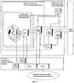
Схема организации сотовой связи на основе указанных принципов представлена на фиг.1, их объединение создает технологическую основу сотовой связи для предоставления услуг абонентам. На фиг.2 приведена общая структурная схема системы сотовой связи (см. например, Williams C.Y.Lee. Mobile Cellular Telecommunications. Analog and Digital Systems. Second Edition. McGraw-Hill, Inc. 1995, 664 p.)The organization of cellular communications based on these principles is presented in figure 1, their combination creates the technological basis of cellular communications to provide services to subscribers. Figure 2 shows the General block diagram of a cellular communication system (see, for example, Williams C.Y. Lee. Mobile Cellular Telecommunications. Analog and Digital Systems. Second Edition. McGraw-Hill, Inc. 1995, 664 p.)
Абонент через свою мобильную станцию (MS) передает сообщения другим мобильным абонентам или абонентам фиксированной сети связи (PSTN) через базовую станцию (BTS), последовательно соединенный с базовой станцией контроллер (BSC) и центр коммутации подвижной связи (MSC), соединенный с визитным регистром (VLR), отслеживающим перемещения абонента, а также с домашним регистром (HLR), в котором содержатся все необходимые данные об абонентах, заключивших контракт с оператором сети и получивших модуль идентификации абонента (SIM-карту) данного оператора. Работа сети контролируется центром управления системы сотовой связи - ОМС (Oper. and Maint. Centre).A subscriber through his mobile station (MS) transmits messages to other mobile subscribers or subscribers of a fixed communication network (PSTN) through a base station (BTS), a controller (BSC) connected in series to a base station and a mobile switching center (MSC) connected to a business register (VLR), which tracks the movement of the subscriber, as well as with the home register (HLR), which contains all the necessary data about subscribers who have signed a contract with a network operator and received a subscriber identity module (SIM card) of this operator. The network is controlled by the control center of the cellular communication system - OMS (Oper. And Maint. Center).
В схеме сотовой связи фиг.2 определение местоположения мобильного абонента (MS) осуществляется в рамках “зоны определения местоположения” (Location Area), которая включает контроллер базовых станций (BSC) и все подключенные к нему базовые станции (BTS). В рамках Location Area можно идентифицировать соту или сектор соты, в которой находится MS, например, для того, чтобы обеспечить мобильной станции доставку входящего сообщения от абонента PSTN или другой мобильной станции системы сотовой связи. При этом точность определения местоположения MS зависит от размеров соты и может составлять от нескольких сотен метров до десятков километров.In the cellular communications scheme of FIG. 2, the location of a mobile subscriber (MS) is carried out within the “Location Area” (Location Area), which includes a base station controller (BSC) and all base stations connected to it (BTS). Within the Location Area, you can identify the cell or sector of the cell in which the MS is located, for example, in order to enable the mobile station to deliver an incoming message from a PSTN subscriber or other mobile station of the cellular communication system. Moreover, the accuracy of determining the location of MS depends on the size of the cell and can range from several hundred meters to tens of kilometers.
Для активных мобильных станций, зарегистрированных в VLR, система сотовой связи должна непрерывно определять местоположение, по каналам управления и сигнализации, передаваемым совместно с каналами графика по сетевым интерфейсам (A-bis, A, M и др.), для физической реализации которых необходимо использовать радиорелейные, проводные или оптоволоконные линии связи. Например, для управления процессами связи (включая соединение MS, handover, передачу сообщений, управление мощностью передачи) в сетях сотовой связи GSM выделяются от одного до двух временных окон (TS) из восьми, содержащихся во временном кадре (TDMA-кадр), формируемом на одном из 124 частотных каналов (см. например, Siegmund M.Rede, Mathias К. Weber, Malcolm W. Oliphant. An Introduction to GSM. Artech House, Inc. 1995, 379 p.). Таким образом от 12,5 до 25% ресурса сети не используется для передачи трафика.For active mobile stations registered in VLR, the cellular communication system must continuously determine the location using the control and signaling channels transmitted together with the chart channels via network interfaces (A-bis, A, M, etc.), for the physical implementation of which it is necessary to use radio relay, wire or fiber optic communication lines. For example, to control communication processes (including MS connection, handover, messaging, transmission power control) in GSM cellular networks, one to two time windows (TS) out of eight contained in a time frame (TDMA frame) formed on one of 124 frequency channels (see, for example, Siegmund M.Rede, Mathias K. Weber, Malcolm W. Oliphant. An Introduction to GSM. Artech House, Inc. 1995, 379 p.). Thus, from 12.5 to 25% of the network resource is not used to transmit traffic.
Кроме того, тенденции развития услуг новых поколений сотовой связи - третьего (3G) и четвертого (4G), а также действующих систем сотовой связи поколения 2,5G, предусматривают широкое внедрение новых видов услуг, связанных с местоположением абонентов (см., например, Juha Korhenen. Introduction to 3G Mobile Communications. Second Edition. Artech House, Inc., 2003, 544 p.).In addition, the trends in the development of services of new generations of cellular communications - the third (3G) and fourth (4G), as well as the existing 2.5G cellular communication systems, provide for the widespread introduction of new types of services related to the location of subscribers (see, for example, Juha Korhenen, Introduction to 3G Mobile Communications, Second Edition, Artech House, Inc., 2003, 544 p.).
К таким услугам относятся, например, навигационные услуги, услуги экстренной помощи, туристический справочник, охрана перевозимых грузов и т.д. Реализация этих услуг возможна при повышении точности определения местоположения мобильных станций, что достигается дополнительным усложнением системы сотовой связи в целом, повышением стоимости оборудования и программного обеспечения сотовой связи за счет включения новых элементов, например, включения измерительных модулей (LMU - Line Measurement Unit) типа А, подключаемых по радиоинтерфейсу к базовым станциям или LMV типа В, подключаемых к контроллеру базовых станций (BSC) по сетевому A-bis интерфейсу, а также центров определения местоположения MLC (Mobile Location Centre). Один из них - SMLC (Serving MLC) - обслуживает запросы на определение местоположения, осуществляет окончательный расчет координат и точности полученного результата, другой - GMLC (Gateway MLC) выполняет функции поддержки клиентов (см., например, ETSI TS 101 723 (GSM 02.71): Digital Cellular Telecommunications System (Phase 2+); Location Services (LCS); Service Description; Stage 1." ETSI TS 122-71 (3GPP TS 22.071): Digital Cellular Telecommunications System (Phase 2+) (GSM); Universal Mobile Telecommunications System (UMTS); Location Services (LCS); Service Description, Stage 1").Such services include, for example, navigation services, emergency services, a tourist guide, guarding transported goods, etc. The implementation of these services is possible by increasing the accuracy of determining the location of mobile stations, which is achieved by further complicating the cellular communication system as a whole, increasing the cost of equipment and software for cellular communications by including new elements, for example, including measuring modules (LMU - Line Measurement Unit) of type A connected via radio to base stations or type B LMV, connected to base station controller (BSC) via A-bis network interface, as well as MLC location centers (Mob ile Location Center). One of them - SMLC (Serving MLC) - serves location requests, performs the final calculation of coordinates and accuracy of the result, the other - GMLC (Gateway MLC) performs customer support functions (see, for example, ETSI TS 101 723 (GSM 02.71) : Digital Cellular Telecommunications System (Phase 2+); Location Services (LCS); Service Description; Stage 1. "ETSI TS 122-71 (3GPP TS 22.071): Digital Cellular Telecommunications System (Phase 2+) (GSM); Universal Mobile Telecommunications System (UMTS); Location Services (LCS); Service Description, Stage 1 ").
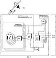
Структурная схема сети сотовой связи с поддержкой функций определения местоположения на основе дополнительных измерительных модулей, принятая для стандартов GSM и практически совпадающая с аналогичной схемой нового поколения сотовой связи - 3G (UMTS) приведена на фиг.3.The block diagram of a cellular network with support for location functions based on additional measuring modules, adopted for GSM standards and almost coinciding with a similar scheme of the new generation of cellular communications - 3G (UMTS) is shown in Fig.3.
Известны методы определения местоположения MS по схеме фиг.3, основанные на данных сети сотовой связи, наиболее известным из которых является метод идентификации соты (Cell ID), для которого не требуется определения уровня сигнала или его задержки, так как это является внутренним свойством сетей сотовой связи. В качестве основных методов определения местоположения MS для сетей сотовой связи GSM выбраны следующие: Cell ID-TA (Timing Advance), TOA (Time Of Arrival), E-OTD (Enhanced Observed Time Difference) (см., например, ETSI TS.101 724 (3GPP TS 03.71): Digital Cellular Telecommunications System (Phase 2+), Location Services (LCS), Functional Description - Stage 2).Known methods for determining the location of the MS according to the scheme of figure 3, based on data from a cellular network, the most famous of which is the method of cell identification (Cell ID), which does not require determination of the signal level or its delay, as this is an internal property of cellular networks communication. The following methods were chosen as the main methods for determining the MS location for GSM cellular networks: Cell ID-TA (Timing Advance), TOA (Time Of Arrival), E-OTD (Enhanced Observed Time Difference) (see, for example, ETSI TS.101 724 (3GPP TS 03.71): Digital Cellular Telecommunications System (Phase 2+), Location Services (LCS), Functional Description - Stage 2).
Для сетей 3G выбор метода определения местоположения определяется видом сети радиодоступа. В случае UMTS (UTRAN) рекомендованы методы Cell ID-TA и ОТ DOA (Observed Time Difference Of Arrival) (см., например, ETSI TS 125 395 (3PGG TS 25.395): Universal Mobile Telecommunications System (UMTS); Stage 2, Functional Description on UE Positioning in UTRAN).For 3G networks, the choice of location method is determined by the type of radio access network. In the case of UMTS (UTRAN), Cell ID-TA and OT DOA (Observed Time Difference Of Arrival) methods are recommended (see, for example, ETSI TS 125 395 (3PGG TS 25.395): Universal Mobile Telecommunications System (UMTS); Stage 2, Functional Description on UE Positioning in UTRAN).
Указанные методы определения местоположения MS на основе сети сотовой связи для своей реализации требуют установки дополнительного оборудования и программного обеспечения, для их внедрения в сеть сотовой связи необходимо выделение дополнительных соединительных линий.The indicated methods for determining the location of an MS based on a cellular network for their implementation require the installation of additional equipment and software; for their implementation in a cellular network, additional connecting lines must be allocated.
Кроме того, указанные методы определения местоположения MS на основе сети сотовой связи не изменяют общие принципы построения сети, представленные на фиг.1. Точность определения местоположения MS в этих методах составляет несколько сотен метров.In addition, these methods for determining the location of the MS based on the cellular network do not change the general principles of network construction, presented in figure 1. The MS location accuracy in these methods is several hundred meters.
Известны методы определения местоположения абонента на основе мобильной станции, когда MS определяет местоположение независимо от оператора сети. К числу методов определения местоположения на базе MS относятся методы GPS или A-GPS (Assisted GPS), в последнем для получения координат MS используются данные от дополнительных (assisted) передатчиков сигналов GPS, установленных на земле в зоне сети сотовой связи.Known methods for determining the location of the subscriber based on the mobile station, when the MS determines the location regardless of the network operator. MS-based location methods include GPS or A-GPS (Assisted GPS) methods, the latter using data from additional (assisted) GPS signal transmitters installed on the ground in a cellular network area to obtain MS coordinates.
GPS - глобальная спутниковая система определения местоположения была разработана и эксплуатируется Министерством обороны США для обеспечения наземных объектов по всеми миру точной информацией о положении, скорости и текущем времени. Орбитальная группировка включает 28 спутников, постоянно задействовано не менее 24 спутников. Аналогичные задачи решает российская глобальная спутниковая система определения местоположения GLONASS. Разрабатывается европейская глобальная спутниковая система определения местоположения GALILEO (см., например, Ю.А.Соловьев. Системы спутниковой навигации. - М.: Эко-Трендз, 2000, 270 с.). Точность определения местоположения с помощью GPS может составлять около 10 метров. Точность определения местоположения повышается при применении A-GPS и может составлять несколько десятков сантиметров.GPS - a global satellite positioning system was developed and operated by the US Department of Defense to provide ground-based objects around the world with accurate information about position, speed and current time. The orbital constellation includes 28 satellites, at least 24 satellites are constantly involved. Similar tasks are solved by the Russian global satellite-based positioning system GLONASS. A European global satellite positioning system GALILEO is being developed (see, for example, Yu.A. Soloviev. Satellite navigation systems. - M.: Eco-Trends, 2000, 270 pp.). GPS accuracy can be around 10 meters. The accuracy of positioning is improved with the use of A-GPS and can be several tens of centimeters.
При определении местоположения MS с использованием GPS или А-GPS мобильная станция с встроенным GPS приемником передает свои координаты через базовые станции (BTS) и контроллер (BSC) в центр управления системы сотовой связи (ОМС) по каналам передачи коротких сообщений (SMS) или по другим каналам, в частности по каналам подсистемы пакетной передачи данных (GPRS).When determining the MS location using GPS or A-GPS, a mobile station with a built-in GPS receiver transmits its coordinates through base stations (BTS) and a controller (BSC) to the control center of a cellular communication system (OMS) via short message channels (SMS) or via other channels, in particular through the channels of the packet data subsystem (GPRS).
Однако в этих известных способах определения местоположения на основе глобальных спутниковых систем сеть сотовой связи и система GPS (GLONASS и др.) работают независимо друг от друга. В системах сотовой связи для передачи сообщений, для обеспечения непрерывности связи ("handover"), для повторного использования частот в сети или кодов в сотах, а также управления режимами работы базовых и мобильных станций, данные от глобальных спутниковых систем определения местоположения не используются. Поэтому загружаются каналы связи, используется дополнительное оборудование и программное обеспечение, а точность определения местоположения ограничивается точностью "до соты", размеры которой могут составлять от нескольких сотен метров до десятков километров.However, in these known methods for determining locations based on global satellite systems, the cellular network and the GPS system (GLONASS and others) operate independently of each other. In cellular communication systems for data transmission, to ensure continuity of communication ("handover"), for the reuse of frequencies on the network or codes in cells, as well as for controlling the operating modes of base and mobile stations, data from global satellite positioning systems are not used. Therefore, communication channels are downloaded, additional equipment and software are used, and the accuracy of determining the location is limited to "to a cell" accuracy, the dimensions of which can range from several hundred meters to tens of kilometers.
Известно применение GPS как независимого от сотовой сети источника сигналов синхронизации в системах сотовой связи с кодовым разделением каналов (CDMA, IS-95) (см., например, Jhong Sam Lee, Leonard E. Miller. CDMA Systems Engineering Handbook. Artech House. 1998, 1228 p.), но и в этом случае GPS и сеть сотовой связи не взаимосвязаны.It is known to use GPS as a cell-independent synchronization signal source in cellular code division multiple access (CDMA, IS-95) systems (see, for example, Jhong Sam Lee, Leonard E. Miller. CDMA Systems Engineering Handbook. Artech House. 1998 , 1228 p.), But even in this case, GPS and the cellular network are not interconnected.
По технической сущности наиболее близким к предлагаемому изобретению является способ сотовой связи, реализованный в системе сотовой связи GSM, в которой данные местоположения мобильной станции GSM, полученные от приема сигналов спутниковой системы связи GPS, используются для поиска и передачи сигналов тревоги (см. патент US №6411811 В2, или M 04 Q 7/20 от 25.06.2002 г.).In technical essence, the closest to the proposed invention is a cellular communication method implemented in a GSM cellular communication system in which the location data of a GSM mobile station obtained from receiving signals from a GPS satellite communications system are used to search and transmit alarm signals (see US Pat. No. 6411811 B2, or M 04 Q 7/20 dated 06/25/2002).
Однако несмотря на то, что при использовании известного способа расширяется состав услуг связи сети GSM, данные местоположения MS, полученные от GPS, не используются для оптимизации работы системы сотовой связи, что не приводит к снижению нагрузки в каналах связи, а решение задачи определения местоположения по-прежнему решается на основе ресурсов и оборудования сети сотовой связи (фиг.1).However, despite the fact that when using the known method, the range of GSM network communication services is expanded, the MS location data received from GPS are not used to optimize the operation of the cellular communication system, which does not reduce the load on the communication channels, and the solution to the location problem by - is still being decided on the basis of the resources and equipment of the cellular network (Fig. 1).
В известном способе использование данных от GPS для передачи сигналов тревоги и предоставления услуг, связанных с местоположением мобильных абонентов, не изменяет структуру сети сотовой связи, ее базовые принципы (фиг.1) и не заменяет отдельные функции системы сотовой связи.In the known method, the use of data from GPS for transmitting alarms and providing services related to the location of mobile subscribers does not change the structure of the cellular communication network, its basic principles (Fig. 1) and does not replace individual functions of the cellular communication system.
Техническим результатом изобретения является повышение эффективности систем сотовой связи за счет повышения их пропускной способности (емкости), снижения нагрузки на сетевых интерфейсах, по которым передается служебная информация (например, между MS и BTS, BTS и BSC, BSC и MSC), и использования освобожденных ресурсов для передачи полезной нагрузки, сокращения состава оборудования и программного обеспечения сотовой связи, ответственного за определение местоположения MS, (LMU, SMLC, GMLC и др.), а также повышения точности определения местоположения MS.The technical result of the invention is to increase the efficiency of cellular communication systems by increasing their bandwidth (capacity), reducing the load on network interfaces that transmit service information (for example, between MS and BTS, BTS and BSC, BSC and MSC), and using freed resources for transferring the payload, reducing the composition of the equipment and software for cellular communications, responsible for determining the location of MS, (LMU, SMLC, GMLC, etc.), as well as improving the accuracy of determining the location of MS.
Дополнительным техническим результатом является расширение функциональных возможностей системы сотовой связи за счет создания сот, расположенных на разной высоте от поверхности земли (например, на разных этажах зданий), а также осуществления вертикального "handover", организации корпоративных групп мобильных абонентов внутри сот, использования данных о местоположении мобильной станции для формирования максимума диаграммы направленности многолучевых антенн с управляемой диаграммой направленности в направлении на MS.An additional technical result is the expansion of the functionality of the cellular communication system through the creation of cells located at different heights from the earth's surface (for example, on different floors of buildings), as well as the implementation of vertical “handover”, organization of corporate groups of mobile subscribers within cells, and the use of data on the location of the mobile station to form the maximum radiation pattern of multi-beam antennas with a controlled radiation pattern in the direction of the MS.
Достигается это тем, что в способе сотовой связи, согласно изобретению, в центр управления системы сотовой связи предварительно вводят файл в электронном виде с фрагментами цифровой географической карты местности, содержащей координаты и характеристики базовых станций, установленных в сотах, и географические координаты границ сот, при этом в процессе радиосвязи определяют с помощью встроенного в мобильную станцию приемника спутниковой системы определения местоположения и передают на базовую станцию в центр управления системы сотовой связи данные о местоположении соответствующей мобильной станции, а из центра управления системы сотовой связи через соответствующую базовую станцию передают на мобильную станцию файл фрагмента цифровой географической карты, содержащей координаты и характеристики базовой станции той соты, где находится данная мобильная станция, и соседних сот с координатами их границ, далее производят в мобильной станции сравнение текущих данных ее местоположения с координатами границ сот, при переходе мобильной станции в другую соту -"handover" - и/или при переходе из одной сети сотовой связи в другую - роуминг - вырабатывают в мобильной станции и передают в соответствующий центр управления системы сотовой связи данные о совершении "handover" или осуществлении роуминга и изменения рабочих параметров каналов связи, кроме того, синхронизацию работы мобильных и базовых станций осуществляют по сигналам спутниковой системы определения местоположения, кроме того, размер фрагмента цифровой географической карты, передаваемого на мобильную станцию, и периодичность передачи этой мобильной станцией в центр управления системы сотовой связи данных о своем местоположении изменяют в зависимости от скорости перемещения мобильной станции, текущие данные местоположения мобильной станции используют для управления параметрами адаптивных многолучевых антенных систем базовых станций, в том числе для управления диаграммой направленности антенн в направлении на мобильную станцию, причем внутри соты выделяют микросоты с рабочими параметрами связи, отличными от рабочих параметров связи данной соты, в частности, другие виды радиоинтерфейсов, протоколов, стандартов связи, при этом координаты границ и рабочие параметры этих микросот, записанные в центре управления системы сотовой связи, передают через соответствующие базовые станции на мобильные станции, находящиеся в микросотах, а в качестве одного из рабочих параметров выбирают высоту нахождения мобильной станции над уровнем поверхности земли, по отношению к которому выделяют соответствующие соты или микросоты и обеспечивают вертикальный "handover", а также регулируют уровень мощности передатчиков мобильных и базовых станций в зависимости от удаления их друг от друга на основе данных местоположения мобильных и базовых станций, а также цифровых географических карт, представленных в электронной форме, используемых в центре управления системы сотовой связи, кроме того, при передаче файла фрагмента цифровой географической карты из центра управления системы сотовой связи через базовую станцию на соответствующую мобильную станцию осуществляют адаптацию размеров и конфигурации сот, а также условий обеспечения "handover" к нагрузке, создаваемой мобильными станциями в соте, причем в зависимости от местоположения мобильной станции в определенной соте или определенной зоне сотовой связи каждой мобильной станции определяют приоритеты доступа к услугам связи или предельные качественные характеристики связи, или исключают доступ к услугам связи или части услуг связи на отдельных участках зоны сотовой связи или соты, кроме того, обеспечивают точечную или зоновую с произвольной конфигурацией зон тарификацию услуг связи, предоставляемых абонентам (например, вдоль автомобильных трасс или железных дорог), а текущие данные местоположения мобильной станции, доступные мобильному абоненту сотовой сети в глобальном масштабе, используют для выбора сети мобильной связи, действующей на определенной территории, и доступного вида услуг в этой сети путем соответствующего программирования мобильной станции абонентом или оператором мобильной связи, в том числе с учетом действующих тарифов на услуги связи (например, минимальных) в сетях связи разных операторов.This is achieved by the fact that in the cellular communication method according to the invention, a file in electronic form with fragments of a digital geographic map of the area containing the coordinates and characteristics of base stations installed in the cells and the geographical coordinates of the borders of the cells is preliminarily introduced into the control center of the cellular communication system, when in the process of radio communication this is determined using the satellite positioning system receiver integrated in the mobile station and transmitted to the base station in the control center of the cellular system data on the location of the corresponding mobile station, and from the control center of the cellular communication system, through the corresponding base station, a digital geographic map fragment file containing the coordinates and characteristics of the base station of the cell where the mobile station is located and neighboring cells with their coordinates is transmitted to the mobile station borders, then make a comparison in the mobile station of the current data of its location with the coordinates of the borders of the cells, when the mobile station moves to another cell - “handover” - and / or and transferring from one cellular network to another — roaming — they generate data in the mobile station and transmit to the appropriate control center of the cellular communication system a “handover” or roaming and change of the operating parameters of the communication channels, in addition, synchronization of the operation of mobile and base stations carried out by the signals of the satellite positioning system, in addition, the fragment size of the digital geographic map transmitted to the mobile station, and the frequency of transmission by this mobile station to the control center of the cellular communication system, the location data is changed depending on the speed of the mobile station, the current location data of the mobile station is used to control the parameters of adaptive multipath antenna systems of base stations, including to control the antenna pattern in the direction of the mobile station, microcells with operating communication parameters different from the operating communication parameters of a given cell, in particular, other types of radio interfaces, are allocated inside the cell , protocols, communication standards, while the coordinates of the borders and operating parameters of these microcells recorded in the control center of the cellular communication system are transmitted through the appropriate base stations to mobile stations located in microcells, and as one of the operating parameters, the height of the mobile station above level of the earth’s surface, in relation to which appropriate cells or microcells are allocated and provide vertical “handover”, and also regulate the power level of the transmitters of mobile and base stations depending on their removal from each other based on the location data of mobile and base stations, as well as digital geographic maps presented in electronic form, used in the control center of the cellular communication system, in addition, when transferring a file of a fragment of a digital geographical map from the control center cellular communication systems through the base station to the appropriate mobile station adapt the cell size and configuration, as well as the conditions for providing "handover" to the load created by mobile stations in a cell, moreover, depending on the location of the mobile station in a specific cell or a certain area of cellular communication of each mobile station, priorities for access to communication services or ultimate quality characteristics of communication are determined, or they exclude access to communication services or parts of communication services in separate sections of the cellular communication zone or Cells, in addition, provide point or zone with an arbitrary configuration of zones tariffication of communication services provided to subscribers (for example, along highways or railways) and the current location data of the mobile station, accessible to the mobile subscriber of the cellular network on a global scale, is used to select the mobile communication network operating in a certain territory and the available type of services in this network by appropriately programming the mobile station by the subscriber or mobile operator, including taking into account current tariffs for communication services (for example, minimum) in communication networks of different operators.
Сущность изобретения заключается в формировании конфигурации сот базовых станций, границами которых является совокупность географических координат, обеспечении процедуры перехода из соты в соту при пересечении указанных границ сот и определении местоположения мобильной станции на основе координат, получаемых от спутниковой системы местоопределения, например GPS. При этом передают от мобильных станций, содержащих приемник спутниковой системы определения местоположения, текущие данные местоположения мобильных станций через базовые станции системы сотовой связи в центр управления системой сотовой связи, который формирует фрагменты географической карты в электронной (цифровой) форме, включающей координаты границ соты данной базовой станции и сот соседних базовых станций, их рабочих параметров каналов связи (частот, кодов и т.п.), и передает мобильным станциям указанные фрагменты географических карт для запоминания их и последующего сравнения на мобильной станции с текущими данными спутникового определения местоположения с целью определения рабочих параметров каналов связи и обеспечения процедуры перехода мобильной станции из одной соты в другую, или из одной сети в другую при роуминге, или при смене одного вида радиодоступа или сети связи на другой.The essence of the invention lies in the formation of the configuration of the cells of the base stations, the boundaries of which are a set of geographical coordinates, providing a procedure for switching from cell to cell when crossing the specified cell boundaries and determining the location of the mobile station based on the coordinates received from a satellite positioning system, for example GPS. In this case, the current location data of the mobile stations are transmitted from mobile stations containing a receiver of a satellite positioning system through base stations of a cellular communication system to a control center of a cellular communication system, which generates fragments of a geographical map in electronic (digital) form, including coordinates of the cell boundaries of this base stations and hundreds of neighboring base stations, their operating parameters of communication channels (frequencies, codes, etc.), and transmits the indicated fragments of geographical to RT for storing them and then comparing them at the mobile station with the current satellite positioning data in order to determine the operating parameters of the communication channels and to ensure the procedure for the mobile station to move from one cell to another, or from one network to another when roaming, or when changing one type of radio access or communication networks to another.
Кроме того, периодичность определения местоположения мобильной станции и размеры фрагмента географической карты адаптируются к скорости перемещения мобильной станции, а данные его спутникового местоопределения используют на базовых станциях для изменения параметров диаграмм направленности антенн базовых станций в целях увеличения дальности связи, повышения качества связи и емкости сети. Формирование внутри сот микросот с рабочими параметрами связи, отличными от параметров сот, и связанными, в том числе, с высотой нахождения мобильной станции, обеспечивает возможность надежной связи с летательными аппаратами, включая взаимодействие с высокоподнятыми радиоретрансляторами, например, HAPS (High Altitude Platform Station).In addition, the frequency of determining the location of the mobile station and the size of the fragment of the geographic map are adapted to the speed of the mobile station, and its satellite location data is used at base stations to change the parameters of the antenna patterns of the base stations in order to increase the communication range, improve communication quality and network capacity. The formation within microcells of microcells with operating communication parameters different from the cell parameters and related, including with the height of the mobile station, provides the possibility of reliable communication with aircraft, including interaction with high-raised radio transmitters, for example, HAPS (High Altitude Platform Station) .
По существу, повышение эффективности сотовой связи получено путем исключения из известного способа сотовой связи (фиг.1) функции определения местоположения, реализуемой сетью сотовой связи, и построения системы сотовой связи с использованием ресурсов глобальной спутниковой системы определения местоположения типа GPS, GLONASS, GALILEO или других аналогичных спутниковых систем для реализации функций определения местоположения в составе сети сотовой связи, а также обеспечения "handover", повторного использования частот или кодов, разделяющих каналы связи, и других функций с передачей файлов данных цифровых географических карт на мобильные станции. При этом производят в мобильной станции сравнение текущих данных о ее местоположении с координатами границ этой соты, при переходе мобильной станции в другую соту и/или при переходе из одной сети сотовой связи в другую, вырабатывают в ней и передают в соответствующий центр управления сетью сотовой связи данные для "handover" или роуминга и изменения рабочих параметров каналов связи, причем синхронизацию работы мобильных и базовых станций осуществляют по сигналам спутниковой системы определения местоположения.Essentially, improving the efficiency of cellular communications is obtained by eliminating from the known cellular communications method (FIG. 1) the location function implemented by the cellular communications network and constructing a cellular communications system using the resources of a global satellite positioning system such as GPS, GLONASS, GALILEO or other similar satellite systems for the implementation of positioning functions in the cellular network, as well as providing "handover", reuse of frequencies or codes sharing channels communication, and other functions with the transfer of digital geographic map data files to mobile stations. In this case, the current station location data is compared in the mobile station with the coordinates of the borders of this cell, when the mobile station moves to another cell and / or when it moves from one cellular network to another, it is generated in it and transferred to the corresponding control center of the cellular communication network data for "handover" or roaming and changes in the operating parameters of communication channels, moreover, the synchronization of the operation of mobile and base stations is carried out by the signals of the satellite positioning system.
Сравнение предлагаемого технического решения с ближайшим аналогом позволяет утверждать о соответствии критерию "новизна", а отсутствие отличительных признаков в аналогах говорит о соответствии критерию "изобретательский уровень".Comparison of the proposed technical solution with the closest analogue allows us to claim compliance with the criterion of "novelty", and the absence of distinctive features in the analogs indicates compliance with the criterion of "inventive step".
Предварительные испытания позволяют утверждать о возможности промышленного использования.Preliminary tests suggest the possibility of industrial use.
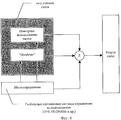
Схемы организации сотовой связи, реализующие заявленный способ, представлены на фиг.4 и фиг.5.The organization of cellular communications that implement the claimed method are presented in figure 4 and figure 5.
В системе, изображенной на фиг.5, определение местоположения мобильных станций осуществляется не элементами системы сотовой связи, а осуществляется внешней по отношению к системе сотовой связи системой определения местоположения, в качестве которой предлагается использовать глобальную спутниковую систему определения местоположения мобильных объектов (GPS, GLONASS и т.д.)In the system depicted in FIG. 5, the location of mobile stations is not carried out by elements of a cellular communication system, but rather by an external positioning system relative to the cellular communication system, which is proposed to use a global satellite-based positioning system for mobile objects (GPS, GLONASS and etc.)
Рассмотрим подробнее функционирование системы сотовой связи согласно заявляемому способу.Let us consider in more detail the functioning of the cellular communication system according to the claimed method.
На основе цифровой карты местности, учитывающей застройку (высоту и размеры зданий, конфигурацию улиц и т.д.) и модели распространения радиоволн в условиях различной застройки, применительно к заданному частотному диапазону и выделенному частотному ресурсу рассчитывают зону покрытия связью с учетом прогнозируемых нагрузок в каналах связи, требований к надежности и качеству связи, характеристик направленности антенн, условий электромагнитной совместимости с другими радиоэлектронными средствами, требований обеспечения "handover" и т.д. В результате расчета определяют координаты, высоту размещения и параметры базовых станций в системе связи. Для каждой базовой станции формируют конфигурацию ее соты, которую в виде координат границ соты, в том числе и пространственных, записывают в электронном виде и хранят в центре управления системы сотовой связи (ОМС), откуда необходимые данные передают и записывают в контроллеры (BSC) для управления соответствующими базовыми станциями (BTS). Эти данные вместе с координатами границ соседних сот, их рабочих частот, кодов и параметров связи образуют цифровую географическую карту в виде фрагментов в электронной форме.Based on a digital map of the area, taking into account the building (the height and size of buildings, street configuration, etc.) and the radio wave propagation model under different building conditions, in relation to a given frequency range and allocated frequency resource, the coverage area is calculated taking into account the predicted loads in the channels communications, requirements for reliability and quality of communications, directional characteristics of antennas, conditions of electromagnetic compatibility with other electronic devices, requirements for providing a "handover", etc. As a result of the calculation, the coordinates, placement height and parameters of base stations in the communication system are determined. For each base station, the configuration of its cell is formed, which, in the form of coordinates of the boundaries of the cell, including spatial ones, is recorded electronically and stored in the control center of the cellular communication system (OMS), from where the necessary data is transmitted and recorded to controllers (BSC) for management of the respective base stations (BTS). This data, together with the coordinates of the borders of neighboring cells, their operating frequencies, codes and communication parameters form a digital geographic map in the form of fragments in electronic form.
Центр управления системы сотовой связи (ОМС) может быть выполнен аналогично центрам управления существующих систем сотовой связи на основе ПЭВМ типа PC, но снабжен соответствующим программным обеспечением для выполнения всех операций по реализации заявляемого способа.The control center of a cellular communication system (OMC) can be performed similarly to the control centers of existing cellular communication systems based on a PC type PC, but is equipped with appropriate software to perform all operations to implement the proposed method.
Спутниковая система определения местоположения включает в себя совокупность спутников (более трех), что позволяет мобильной станции осуществлять определение местоположения не только в плоскости поверхности земли, но и в пространстве, а также осуществляет временную синхронизацию работы мобильных и базовых станций.The satellite positioning system includes a set of satellites (more than three), which allows the mobile station to determine the location not only in the plane of the earth's surface, but also in space, and also temporarily synchronizes the operation of mobile and base stations.
Примечание: в данном контексте термин "мобильная станция" соответствует термину "мобильный абонент", поскольку прослеживается однозначная связь понятий - мобильная станция - это неотъемлемая принадлежность мобильного абонента сотовой сети.Note: in this context, the term "mobile station" corresponds to the term "mobile subscriber", since there is an unambiguous connection of concepts - a mobile station is an integral part of a mobile subscriber of a cellular network.
Мобильная станция (MS), в состав которой должен входить терминал сотовой связи, приемник спутниковой системы определения местоположения и контроллер для хранения и обработки данных географической карты, принимая и обрабатывая сигналы со спутников, периодически определяет собственные пространственные, в том числе географические координаты, причем периодичность определения координат адаптирована (привязана) к скорости перемещения мобильного абонента. Если при двух последовательных определениях собственных координат результаты значительно различаются, т.е. мобильный абонент перемещается с большой скоростью (пользуется транспортом), время между местоопределениями (определениями координат) для повышения точности определения местоположения мобильной станции уменьшают.A mobile station (MS), which should include a cellular terminal, a satellite receiver of a positioning system and a controller for storing and processing data from a geographic map, receiving and processing signals from satellites, periodically determines its own spatial, including geographical coordinates, and the frequency determination of coordinates adapted (attached) to the speed of movement of the mobile subscriber. If, with two successive determinations of the proper coordinates, the results are significantly different, i.e. the mobile subscriber moves at high speed (uses transport), the time between location (coordinates) to reduce the accuracy of determining the location of the mobile station is reduced.
Базовая станция (BTS) при первом попадании в ее соту мобильной станции (MS), передает ей фрагмент географической карты в электронной форме, запрошенный из центра управления системы сотовой связи (ОМС), на которой указаны координаты границ данной соты и соседних сот, а также рабочие частоты или коды базовых станций и параметры связи, причем размер фрагмента цифровой географической карты в электронной форме адаптируют к скорости перемещения мобильного абонента.The base station (BTS) when it first hits a mobile station (MS) in its cell transmits to it a fragment of a geographic map in electronic form, requested from the control center of the cellular communication system (OMS), which indicates the coordinates of the borders of the cell and neighboring cells, and operating frequencies or codes of base stations and communication parameters, moreover, the size of a fragment of a digital geographic map in electronic form is adapted to the speed of movement of a mobile subscriber.
Мобильная станция (MS) периодически сравнивает данные определения местоположения, полученные от спутниковой системы GPS (или аналогичной), с фрагментом цифровой географической карты в электронной форме на предмет определения соты своего местоположения (принадлежности к базовой станции (BTS)). При изменении соты своего местоположения мобильная станция (MS) переходит на рабочую частоту или код, а также на параметры связи базовой станции (BTS) соты, в которой она находится.A mobile station (MS) periodically compares location data obtained from a GPS satellite system (or similar) with a fragment of a digital geographic map in electronic form to determine its location cell (belonging to a base station (BTS)). When the cell of its location changes, the mobile station (MS) switches to the operating frequency or code, as well as to the communication parameters of the base station (BTS) of the cell in which it is located.
Таким образом, применение глобальной спутниковой системы определения местоположения для реализации функций определения местоположения в составе системы сотовой связи позволяет значительно сократить нагрузку в каналах управления и сигнализации на сетевых интерфейсах системы сотовой связи.Thus, the use of a global satellite positioning system for the implementation of positioning functions as part of a cellular communication system can significantly reduce the load on the control and signaling channels on the network interfaces of the cellular communication system.
В многоэтажных зданиях, в силу специфических условий распространения радиоволн, различные этажи зданий могут относиться к различным сотам, и пространственное определение местоположения позволяет осуществлять вертикальный "handover", что важно также для обеспечения связи с летательными аппаратами.In multi-storey buildings, due to the specific propagation conditions of radio waves, different floors of buildings can belong to different cells, and spatial positioning allows vertical “handover”, which is also important for communication with aircraft.
Данные определения местоположения, передаваемые MS на базовые станции, позволяют осуществлять связь с мобильными станциями с помощью многолучевых интеллектуальных антенн (см. приложение 1), максимум диаграмм направленности которых ориентирован непосредственно по координатам мобильной станции и, в соответствии с данными ее местоположения, отслеживают перемещения MS.The location data transmitted by MS to the base stations allows communication with mobile stations using multipath intelligent antennas (see Appendix 1), the maximum radiation patterns of which are oriented directly to the coordinates of the mobile station and, in accordance with its location data, track the movements of the MS .
Использование точных координат мобильных станций в системе управления интеллектуальных антенн, полученных от GPS, позволяет исключить режимы плавной перестройки диаграмм направленности адаптивных антенн и ввести режим коммутации лучей, что сокращает время установления соединения.Using the exact coordinates of the mobile stations in the control system of smart antennas obtained from GPS, it is possible to exclude the modes of smooth tuning of the directional patterns of adaptive antennas and introduce a mode of switching beams, which reduces the time to establish a connection.
В пределах одной соты (т.е. при работе на одной группе частот или кодов) возможно формирование микросот с заданными границами географических координат, находясь в которых мобильные абоненты пользуются параметрами связи: видом радиоинтерфейса, скоростью передачи, протоколом связи, тарифом и т.д., отличными от параметров связи соты. То есть, при нахождении мобильного абонента в пределах микросоты он получает ряд льгот или дополнительных услуг.Within one cell (i.e., when working on the same group of frequencies or codes), it is possible to form microcells with specified boundaries of geographical coordinates, in which mobile subscribers use communication parameters: type of radio interface, transmission speed, communication protocol, tariff, etc. ., different from the communication parameters of the cell. That is, when a mobile subscriber is within a microcell, he receives a number of benefits or additional services.
Точное определение местоположения мобильных станций через спутниковую систему определения местоположения позволяет обеспечить роуминг при переходе MS из одной сети связи в другую в рамках одного стандарта связи или разных стандартов связи или разных видов радиосвязи. В этом случае координаты пограничной соты формируются в соответствии с координатами границ (в частности государственных) сетей связи. Мобильный абонент, пересекая государственную границу или зону сотовой связи, получает услуги роуминга сразу после пересечения границы зоны связи, в отличие от действующих в настоящее время сотовых сетей, где зона связи и границы сот зависят от условий распространения радиоволн на местности и принципиально не могут быть однозначно связаны с границами сетей (с границами лицензируемых территорий). Кроме того, использование цифровых электронных карт местности и данных местоположения MS, полученных от глобальных спутниковых систем определения местоположения, с учетом застройки и условий размещения антенных систем базовых станций, а также модели распространения радиоволн, позволяет регулировать уровень мощности передатчиков мобильных и базовых станций в зависимости от удаления их друг от друга.Accurate location of mobile stations through a satellite-based positioning system allows roaming when MS moves from one communication network to another within the same communication standard or different communication standards or different types of radio communications. In this case, the coordinates of the border cell are formed in accordance with the coordinates of the borders (in particular state) of communication networks. A mobile subscriber crossing a state border or a cellular communication zone receives roaming services immediately after crossing the communication zone border, unlike the current cellular networks, where the communication zone and cell boundaries depend on the propagation conditions of radio waves in the area and, in principle, cannot be unambiguously connected with the boundaries of networks (with the boundaries of licensed territories). In addition, the use of digital electronic terrain maps and MS location data obtained from global satellite positioning systems, taking into account the development and placement conditions of the base station antenna systems, as well as the radio wave propagation model, allows you to adjust the power level of the transmitters of mobile and base stations depending on removing them from each other.
В зависимости от нагрузки, создаваемой мобильными станциями в соте, размеры и конфигурация сот, определяемых географическими координатами, а также условия "handover", могут задаваться каждой мобильной станции дистанционно с центра управления системой сотовой связи.Depending on the load created by the mobile stations in the cell, the size and configuration of the cells, determined by geographic coordinates, as well as the “handover” conditions, can be set remotely for each mobile station from the control center of the cellular communication system.
Высокая точность определения местоположения на основе данных глобальной спутниковой системы позволяет, в зависимости от местоположения мобильной станции в определенной соте, каждой мобильной станции определить приоритеты доступа к услугам связи или определить предельные характеристики связи, или вообще исключить доступ в сеть. Заявляемый способ обеспечивает точечную или зоновую с произвольной конфигурацией зон тарификацию услуг связи, предоставляемых абонентам.The high accuracy of positioning based on the data of the global satellite system allows, depending on the location of the mobile station in a particular cell, each mobile station to determine the priorities of access to communication services or to determine the limiting characteristics of communication, or to completely exclude access to the network. The inventive method provides a point or zone with an arbitrary configuration of zones tariffication of communication services provided to subscribers.
Текущие данные местоположения мобильной станции, доступные мобильному абоненту в глобальном масштабе, используют для выбора сети мобильной связи, а также доступного вида услуг в этой сети путем соответствующего программирования мобильной станции абонентом или оператором мобильной связи, в том числе - с учетом действующих тарифов на услуги связи.The current location data of the mobile station, accessible to the mobile subscriber on a global scale, is used to select the mobile communication network, as well as the available type of service in this network by appropriately programming the mobile station by the subscriber or mobile operator, including taking into account current tariffs for communication services .
Таким образом, заявляемый способ позволяет повысить эффективность работы систем сотовой связи за счет использования в составе сети сотовой связи для реализации функций определения местоположения мобильных станций ресурсов глобальной спутниковой системы местоопределения типа GPS, GLONASS и др., в результате чего сокращаются затраты на оборудование и программное обеспечение сотовой связи; снижается нагрузка на сетевых интерфейсах (между MS и BTS, BTS и BSC, BSC и MSC), по которым передается служебная информация, и появляется возможность использовать освобожденные ресурсы сети для передачи полезной нагрузки, повышения емкости сети сотовой связи: повышается точность определения местоположения мобильных станций, что позволяет: реализовать автоматический "handover" при пересечении MS границ сот, заданных в виде системы географических координат и высоты расположения MS, обеспечить управление диаграммами направленности антенн или лучей в адаптивных многолучевых антеннах с максимумом в сторону MS и осуществить управление мощностью излучения базовых и мобильных станций, создавать границы сот и микросот (по географическому принципу) любой формы, а также адаптировать размеры и конфигурацию сот при изменении нагрузки в сотах, обеспечить приоритеты доступа различных групп абонентов в различных зонах сотовой связи, предоставить абонентам услугу точной зоновой тарификации услуг связи, программировать условия связи (используемая сеть, услуги, тарифы), а также осуществлять надежный переход из одной сети связи в другую в процессе поездок абонента.Thus, the claimed method allows to increase the efficiency of cellular communication systems by using the resources of the global satellite positioning system such as GPS, GLONASS, etc. as part of the cellular communication network to implement the functions of determining the location of mobile stations, resulting in reduced hardware and software costs cellular communications; the load on network interfaces is reduced (between MS and BTS, BTS and BSC, BSC and MSC) through which service information is transmitted, and it becomes possible to use the freed network resources to transfer payload, increase the capacity of a cellular communication network: the accuracy of determining the location of mobile stations is improved that allows you to: implement automatic "handover" at the intersection of MS cell boundaries defined in the form of a system of geographical coordinates and the height of the MS, provide control of radiation patterns of antennas or beams to hell multi-beam antennas with a maximum towards MS and to control the radiation power of base and mobile stations, create the boundaries of cells and micro-cells (geographically) of any shape, and also adapt the size and configuration of the cells when the load in the cells changes, provide access priorities for different groups of subscribers in various cellular communication zones, provide subscribers with the exact zone tariffication service for communication services, program communication conditions (used network, services, tariffs), and also provide reliable the transition from one network connection to another subscriber during trips.
Claims (11)
Priority Applications (8)
| Application Number | Priority Date | Filing Date | Title |
|---|---|---|---|
| RU2003124775/09A RU2227373C1 (en) | 2003-08-12 | 2003-08-12 | Cellular communications process |
| PCT/RU2004/000004 WO2005015785A1 (en) | 2003-08-12 | 2004-01-12 | Cellular communication method |
| EP04701442A EP1655863B1 (en) | 2003-08-12 | 2004-01-12 | Cellular communication method |
| DE602004028486T DE602004028486D1 (en) | 2003-08-12 | 2004-01-12 | CELLULAR COMMUNICATION PROCESS |
| AT04701442T ATE476799T1 (en) | 2003-08-12 | 2004-01-12 | CELLULAR COMMUNICATION METHOD |
| US10/510,884 US7228135B2 (en) | 2003-08-12 | 2004-01-12 | Method for cellular communications |
| CN200480000054A CN100589341C (en) | 2003-08-12 | 2004-01-12 | Cellular communication method |
| EA200400228A EA005985B1 (en) | 2003-08-12 | 2004-02-26 | Cellular communication method |
Applications Claiming Priority (1)
| Application Number | Priority Date | Filing Date | Title |
|---|---|---|---|
| RU2003124775/09A RU2227373C1 (en) | 2003-08-12 | 2003-08-12 | Cellular communications process |
Publications (1)
| Publication Number | Publication Date |
|---|---|
| RU2227373C1 true RU2227373C1 (en) | 2004-04-20 |
Family
ID=32466176
Family Applications (1)
| Application Number | Title | Priority Date | Filing Date |
|---|---|---|---|
| RU2003124775/09A RU2227373C1 (en) | 2003-08-12 | 2003-08-12 | Cellular communications process |
Country Status (7)
| Country | Link |
|---|---|
| EP (1) | EP1655863B1 (en) |
| CN (1) | CN100589341C (en) |
| AT (1) | ATE476799T1 (en) |
| DE (1) | DE602004028486D1 (en) |
| EA (1) | EA005985B1 (en) |
| RU (1) | RU2227373C1 (en) |
| WO (1) | WO2005015785A1 (en) |
Cited By (12)
| Publication number | Priority date | Publication date | Assignee | Title |
|---|---|---|---|---|
| CN100399857C (en) * | 2004-06-22 | 2008-07-02 | 大唐移动通信设备有限公司 | Adjacent zone terminal monitoring method in mobile communicating system from network control |
| RU2372733C2 (en) * | 2004-05-04 | 2009-11-10 | ЭлДжи ЭЛЕКТРОНИКС ИНК. | Method of packaged data transmission and mobile communication system using method |
| RU2447620C2 (en) * | 2006-11-17 | 2012-04-10 | Телефонактиеболагет Лм Эрикссон (Пабл) | Transmission of special adjacent cells |
| RU2458464C1 (en) * | 2010-12-13 | 2012-08-10 | Государственное образовательное учреждение высшего профессионального образования Московский авиационный институт (государственный технический университет) (МАИ) | Method to detect location in mobile radio communication networks |
| RU2474052C2 (en) * | 2010-09-20 | 2013-01-27 | Государственное образовательное учреждение высшего профессионального образования "Московский авиационный институт (государственный технический университет) (МАИ)" | Mobile radio communication method |
| RU2475965C2 (en) * | 2010-11-24 | 2013-02-20 | ОАО "Концерн "Созвездие" | Method to assign radio data in cellular network |
| RU2504122C2 (en) * | 2008-09-22 | 2014-01-10 | Нтт Досомо, Инк. | Mobile terminal and radio base station |
| RU2539325C2 (en) * | 2009-02-11 | 2015-01-20 | Этелсат С А | Telecommunication network with multipoint beam communication satellite and control centre determining parameters of transmitted signal according to coordinates of ground terminals |
| RU2548674C2 (en) * | 2010-06-13 | 2015-04-20 | ЗетТиИ Корпорейшн | Method and system of selection of neighbouring candidate cells |
| RU2667390C1 (en) * | 2017-09-27 | 2018-09-19 | Акционерное Общество "Национальный институт радио и инфокоммуникационных технологий" (АО "НИРИТ") | Method of cellular communication |
| RU2724323C2 (en) * | 2013-04-16 | 2020-06-22 | Труфоун Лимитед | International converged mobile communication services |
| RU2798502C1 (en) * | 2022-10-05 | 2023-06-23 | Акционерное Общество "Национальный институт радио и инфокоммуникационных технологий" (АО "НИРИТ") | Method for organizing cellular communications using a mobile repeater |
Families Citing this family (9)
| Publication number | Priority date | Publication date | Assignee | Title |
|---|---|---|---|---|
| US7904055B2 (en) | 2005-08-23 | 2011-03-08 | Lg Electronics Inc. | Communicating message in mobile communication system |
| US8374623B2 (en) | 2006-07-21 | 2013-02-12 | Microsoft Corporation | Location based, software control of mobile devices |
| GB2447931A (en) * | 2007-03-28 | 2008-10-01 | Nec Corp | Mobile radio communications device, related network device and method |
| CN107018525B (en) * | 2016-01-28 | 2020-05-19 | 华为技术有限公司 | Positioning method, device and system |
| CN111800830B (en) * | 2019-04-08 | 2021-07-09 | 华为技术有限公司 | A communication method and device |
| CN112020108B (en) * | 2019-05-30 | 2022-06-10 | 华为技术有限公司 | Cell switching method and device |
| GB2608424B (en) * | 2021-07-01 | 2023-10-18 | Thales Holdings Uk Plc | Aircraft engine blockage avoidance by pre-emptive cell handover |
| CN116089506B (en) * | 2022-08-02 | 2023-09-22 | 国网江苏省电力有限公司无锡供电分公司 | A Beidou positioning data format conversion method based on data center |
| CN120075954B (en) * | 2025-04-28 | 2025-08-05 | 成都耀塔科技有限公司 | Method for communication based on coordinate and matching comparison table |
Citations (3)
| Publication number | Priority date | Publication date | Assignee | Title |
|---|---|---|---|---|
| RU2157565C1 (en) * | 1999-06-10 | 2000-10-10 | Бредихин Иван Васильевич | Method for monitoring of freight delivery |
| US6411811B2 (en) * | 1998-04-20 | 2002-06-25 | Ericsson Inc. | System and method for provisioning assistance global positioning system information to a mobile station |
| RU2207632C2 (en) * | 2001-06-09 | 2003-06-27 | Закрытое акционерное общество "Эскорт" | Method for displaying location of transport vehicle on electronic map of region area of radio systems of dispatcher supervisor of ground transport traffic |
Family Cites Families (13)
| Publication number | Priority date | Publication date | Assignee | Title |
|---|---|---|---|---|
| US5396647A (en) * | 1992-11-03 | 1995-03-07 | Motorola, Inc. | GPS base wide area communication system site selection |
| EP0715291B1 (en) * | 1994-11-28 | 2000-02-23 | MANNESMANN Aktiengesellschaft | Method and device for determining the position of a vehicle |
| US5532690A (en) * | 1995-04-04 | 1996-07-02 | Itt Corporation | Apparatus and method for monitoring and bounding the path of a ground vehicle |
| US6321090B1 (en) * | 1998-11-06 | 2001-11-20 | Samir S. Soliman | Mobile communication system with position detection to facilitate hard handoff |
| US6631263B1 (en) * | 1998-11-06 | 2003-10-07 | Telefonaktiebolaget Lm Ericsson (Publ) | Cell hand-off border identification using MS positioning and signal strength values |
| EP1041738A1 (en) * | 1999-03-30 | 2000-10-04 | ICO Services Ltd. | Doppler correction for a high-speed mobile station in a satellite mobile telephone system |
| CA2316440A1 (en) * | 1999-08-31 | 2001-02-28 | Lucent Technologies Inc. | System for performing handoffs using location information for a wireless unit |
| EP1174728B1 (en) * | 2000-07-18 | 2008-09-24 | Hewlett-Packard Company | Location data diffusion and location discovery |
| KR100416990B1 (en) * | 2000-11-03 | 2004-02-05 | 삼성전자주식회사 | Receiving performance improvement method for network aided gps receiver |
| US7254401B2 (en) * | 2000-12-19 | 2007-08-07 | Nokia Corporation | Network-based method and system for determining a location of user equipment in CDMA networks |
| US20030069043A1 (en) * | 2001-10-10 | 2003-04-10 | Pallav Chhaochharia | Methods and devices for wirelessly transmitting data in dependence on location |
| CN1201511C (en) * | 2001-10-30 | 2005-05-11 | 明基电通股份有限公司 | Positioning device and method |
| US7383049B2 (en) * | 2001-12-27 | 2008-06-03 | Qualcomm Incorporated | Automation of maintenance and improvement of location service parameters in a data base of a wireless mobile communication system |
-
2003
- 2003-08-12 RU RU2003124775/09A patent/RU2227373C1/en active
-
2004
- 2004-01-12 DE DE602004028486T patent/DE602004028486D1/en not_active Expired - Lifetime
- 2004-01-12 EP EP04701442A patent/EP1655863B1/en not_active Expired - Lifetime
- 2004-01-12 WO PCT/RU2004/000004 patent/WO2005015785A1/en not_active Ceased
- 2004-01-12 CN CN200480000054A patent/CN100589341C/en not_active Expired - Fee Related
- 2004-01-12 AT AT04701442T patent/ATE476799T1/en not_active IP Right Cessation
- 2004-02-26 EA EA200400228A patent/EA005985B1/en not_active IP Right Cessation
Patent Citations (3)
| Publication number | Priority date | Publication date | Assignee | Title |
|---|---|---|---|---|
| US6411811B2 (en) * | 1998-04-20 | 2002-06-25 | Ericsson Inc. | System and method for provisioning assistance global positioning system information to a mobile station |
| RU2157565C1 (en) * | 1999-06-10 | 2000-10-10 | Бредихин Иван Васильевич | Method for monitoring of freight delivery |
| RU2207632C2 (en) * | 2001-06-09 | 2003-06-27 | Закрытое акционерное общество "Эскорт" | Method for displaying location of transport vehicle on electronic map of region area of radio systems of dispatcher supervisor of ground transport traffic |
Cited By (12)
| Publication number | Priority date | Publication date | Assignee | Title |
|---|---|---|---|---|
| RU2372733C2 (en) * | 2004-05-04 | 2009-11-10 | ЭлДжи ЭЛЕКТРОНИКС ИНК. | Method of packaged data transmission and mobile communication system using method |
| CN100399857C (en) * | 2004-06-22 | 2008-07-02 | 大唐移动通信设备有限公司 | Adjacent zone terminal monitoring method in mobile communicating system from network control |
| RU2447620C2 (en) * | 2006-11-17 | 2012-04-10 | Телефонактиеболагет Лм Эрикссон (Пабл) | Transmission of special adjacent cells |
| RU2504122C2 (en) * | 2008-09-22 | 2014-01-10 | Нтт Досомо, Инк. | Mobile terminal and radio base station |
| RU2539325C2 (en) * | 2009-02-11 | 2015-01-20 | Этелсат С А | Telecommunication network with multipoint beam communication satellite and control centre determining parameters of transmitted signal according to coordinates of ground terminals |
| RU2548674C2 (en) * | 2010-06-13 | 2015-04-20 | ЗетТиИ Корпорейшн | Method and system of selection of neighbouring candidate cells |
| RU2474052C2 (en) * | 2010-09-20 | 2013-01-27 | Государственное образовательное учреждение высшего профессионального образования "Московский авиационный институт (государственный технический университет) (МАИ)" | Mobile radio communication method |
| RU2475965C2 (en) * | 2010-11-24 | 2013-02-20 | ОАО "Концерн "Созвездие" | Method to assign radio data in cellular network |
| RU2458464C1 (en) * | 2010-12-13 | 2012-08-10 | Государственное образовательное учреждение высшего профессионального образования Московский авиационный институт (государственный технический университет) (МАИ) | Method to detect location in mobile radio communication networks |
| RU2724323C2 (en) * | 2013-04-16 | 2020-06-22 | Труфоун Лимитед | International converged mobile communication services |
| RU2667390C1 (en) * | 2017-09-27 | 2018-09-19 | Акционерное Общество "Национальный институт радио и инфокоммуникационных технологий" (АО "НИРИТ") | Method of cellular communication |
| RU2798502C1 (en) * | 2022-10-05 | 2023-06-23 | Акционерное Общество "Национальный институт радио и инфокоммуникационных технологий" (АО "НИРИТ") | Method for organizing cellular communications using a mobile repeater |
Also Published As
| Publication number | Publication date |
|---|---|
| EP1655863A4 (en) | 2010-02-10 |
| CN100589341C (en) | 2010-02-10 |
| EA200400228A1 (en) | 2005-02-24 |
| DE602004028486D1 (en) | 2010-09-16 |
| EA005985B1 (en) | 2005-08-25 |
| ATE476799T1 (en) | 2010-08-15 |
| CN1698288A (en) | 2005-11-16 |
| EP1655863A1 (en) | 2006-05-10 |
| EP1655863B1 (en) | 2010-08-04 |
| WO2005015785A1 (en) | 2005-02-17 |
Similar Documents
| Publication | Publication Date | Title |
|---|---|---|
| RU2227373C1 (en) | Cellular communications process | |
| CN116058072B (en) | UE location determination and country verification for 5G satellite access | |
| EP4055723B1 (en) | Configuration of fixed tracking areas and fixed cells for a 5g satellite rat | |
| US7228135B2 (en) | Method for cellular communications | |
| US6516197B2 (en) | System and method for reporting the number and/or duration of positioning requests for terminal-based location calculation | |
| JP3860935B2 (en) | Radio base station apparatus and mobile station apparatus | |
| KR100564053B1 (en) | Positioning method and system of cellular mobile terminal | |
| KR100711664B1 (en) | Aided location communication system and device, and method for position determination using the same | |
| KR100660257B1 (en) | System and method for determining the location of a wireless CDM transceiver | |
| KR100684085B1 (en) | Mobile communication system with location detection and hard handoff based thereon | |
| US6295454B1 (en) | System and method for providing chronicled location information for terminal-based position calculation | |
| EP2137838B1 (en) | Method and system for providing location measurement of network based to mobile communication terminal by using g-pcell database according to location | |
| CN102428607B (en) | Automatically directing apparatus and method for communication antenna | |
| US20050272439A1 (en) | Mobile localization in gsm networks | |
| KR20220045311A (en) | V2x network handover system and method thereof | |
| KR20240004405A (en) | Systems and methods for supporting location-based mobility for 5G satellite access to wireless networks | |
| WO2007043915A1 (en) | Adaptive enhanced cell identity positioning | |
| KR102368576B1 (en) | A method and apparatus for performing wireless communication through channel state prediction using local dynamic map | |
| JP2000512101A (en) | Method of using a signal with increased power to determine the location of a mobile subscriber in a CDMA cellular telephone system | |
| Sineglazov et al. | Navigation systems based on GSM | |
| CN117796066A (en) | Systems and methods for tracking areas supporting satellite wireless access | |
| US20060129607A1 (en) | Velocity adjustment in learning cell identity | |
| Lee et al. | Performance evaluation of location-based conditional handover scheme using LEO satellites | |
| GB2609491A (en) | UE location access control | |
| CN116848424A (en) | Positioning system, network device for positioning, mobile station, control circuit, storage medium and positioning method |