JP7157018B2 - Mobile space information processing system, mobile space information processing method, and communication device - Google Patents
Mobile space information processing system, mobile space information processing method, and communication device Download PDFInfo
- Publication number
- JP7157018B2 JP7157018B2 JP2019138607A JP2019138607A JP7157018B2 JP 7157018 B2 JP7157018 B2 JP 7157018B2 JP 2019138607 A JP2019138607 A JP 2019138607A JP 2019138607 A JP2019138607 A JP 2019138607A JP 7157018 B2 JP7157018 B2 JP 7157018B2
- Authority
- JP
- Japan
- Prior art keywords
- information
- moving
- mobile
- representative
- vehicle
- Prior art date
- Legal status (The legal status is an assumption and is not a legal conclusion. Google has not performed a legal analysis and makes no representation as to the accuracy of the status listed.)
- Active
Links
Images


Classifications
-
- G—PHYSICS
- G08—SIGNALLING
- G08G—TRAFFIC CONTROL SYSTEMS
- G08G9/00—Traffic control systems for craft where the kind of craft is irrelevant or unspecified
-
- G—PHYSICS
- G08—SIGNALLING
- G08G—TRAFFIC CONTROL SYSTEMS
- G08G1/00—Traffic control systems for road vehicles
- G08G1/01—Detecting movement of traffic to be counted or controlled
- G08G1/056—Detecting movement of traffic to be counted or controlled with provision for distinguishing direction of travel
-
- G—PHYSICS
- G01—MEASURING; TESTING
- G01C—MEASURING DISTANCES, LEVELS OR BEARINGS; SURVEYING; NAVIGATION; GYROSCOPIC INSTRUMENTS; PHOTOGRAMMETRY OR VIDEOGRAMMETRY
- G01C21/00—Navigation; Navigational instruments not provided for in groups G01C1/00 - G01C19/00
- G01C21/38—Electronic maps specially adapted for navigation; Updating thereof
- G01C21/3804—Creation or updating of map data
- G01C21/3833—Creation or updating of map data characterised by the source of data
- G01C21/3841—Data obtained from two or more sources, e.g. probe vehicles
-
- G—PHYSICS
- G06—COMPUTING; CALCULATING OR COUNTING
- G06V—IMAGE OR VIDEO RECOGNITION OR UNDERSTANDING
- G06V20/00—Scenes; Scene-specific elements
- G06V20/10—Terrestrial scenes
- G06V20/176—Urban or other man-made structures
-
- G—PHYSICS
- G06—COMPUTING; CALCULATING OR COUNTING
- G06V—IMAGE OR VIDEO RECOGNITION OR UNDERSTANDING
- G06V20/00—Scenes; Scene-specific elements
- G06V20/50—Context or environment of the image
- G06V20/56—Context or environment of the image exterior to a vehicle by using sensors mounted on the vehicle
- G06V20/588—Recognition of the road, e.g. of lane markings; Recognition of the vehicle driving pattern in relation to the road
-
- G—PHYSICS
- G08—SIGNALLING
- G08G—TRAFFIC CONTROL SYSTEMS
- G08G1/00—Traffic control systems for road vehicles
- G08G1/01—Detecting movement of traffic to be counted or controlled
- G08G1/0104—Measuring and analyzing of parameters relative to traffic conditions
- G08G1/0108—Measuring and analyzing of parameters relative to traffic conditions based on the source of data
- G08G1/0112—Measuring and analyzing of parameters relative to traffic conditions based on the source of data from the vehicle, e.g. floating car data [FCD]
-
- G—PHYSICS
- G08—SIGNALLING
- G08G—TRAFFIC CONTROL SYSTEMS
- G08G1/00—Traffic control systems for road vehicles
- G08G1/01—Detecting movement of traffic to be counted or controlled
- G08G1/0104—Measuring and analyzing of parameters relative to traffic conditions
- G08G1/0108—Measuring and analyzing of parameters relative to traffic conditions based on the source of data
- G08G1/012—Measuring and analyzing of parameters relative to traffic conditions based on the source of data from other sources than vehicle or roadside beacons, e.g. mobile networks
-
- G—PHYSICS
- G08—SIGNALLING
- G08G—TRAFFIC CONTROL SYSTEMS
- G08G1/00—Traffic control systems for road vehicles
- G08G1/22—Platooning, i.e. convoy of communicating vehicles
-
- G—PHYSICS
- G08—SIGNALLING
- G08G—TRAFFIC CONTROL SYSTEMS
- G08G3/00—Traffic control systems for marine craft
-
- G—PHYSICS
- G08—SIGNALLING
- G08G—TRAFFIC CONTROL SYSTEMS
- G08G5/00—Traffic control systems for aircraft, e.g. air-traffic control [ATC]
- G08G5/0004—Transmission of traffic-related information to or from an aircraft
- G08G5/0013—Transmission of traffic-related information to or from an aircraft with a ground station
-
- H—ELECTRICITY
- H04—ELECTRIC COMMUNICATION TECHNIQUE
- H04W—WIRELESS COMMUNICATION NETWORKS
- H04W4/00—Services specially adapted for wireless communication networks; Facilities therefor
- H04W4/02—Services making use of location information
- H04W4/029—Location-based management or tracking services
-
- H—ELECTRICITY
- H04—ELECTRIC COMMUNICATION TECHNIQUE
- H04W—WIRELESS COMMUNICATION NETWORKS
- H04W4/00—Services specially adapted for wireless communication networks; Facilities therefor
- H04W4/30—Services specially adapted for particular environments, situations or purposes
- H04W4/40—Services specially adapted for particular environments, situations or purposes for vehicles, e.g. vehicle-to-pedestrians [V2P]
-
- G—PHYSICS
- G06—COMPUTING; CALCULATING OR COUNTING
- G06V—IMAGE OR VIDEO RECOGNITION OR UNDERSTANDING
- G06V20/00—Scenes; Scene-specific elements
- G06V20/50—Context or environment of the image
- G06V20/56—Context or environment of the image exterior to a vehicle by using sensors mounted on the vehicle
- G06V20/58—Recognition of moving objects or obstacles, e.g. vehicles or pedestrians; Recognition of traffic objects, e.g. traffic signs, traffic lights or roads
- G06V20/582—Recognition of moving objects or obstacles, e.g. vehicles or pedestrians; Recognition of traffic objects, e.g. traffic signs, traffic lights or roads of traffic signs
-
- G—PHYSICS
- G06—COMPUTING; CALCULATING OR COUNTING
- G06V—IMAGE OR VIDEO RECOGNITION OR UNDERSTANDING
- G06V20/00—Scenes; Scene-specific elements
- G06V20/50—Context or environment of the image
- G06V20/56—Context or environment of the image exterior to a vehicle by using sensors mounted on the vehicle
- G06V20/58—Recognition of moving objects or obstacles, e.g. vehicles or pedestrians; Recognition of traffic objects, e.g. traffic signs, traffic lights or roads
- G06V20/584—Recognition of moving objects or obstacles, e.g. vehicles or pedestrians; Recognition of traffic objects, e.g. traffic signs, traffic lights or roads of vehicle lights or traffic lights
Description
本開示は、移動空間情報処理システム、移動空間情報処理方法および通信装置に関する。 The present disclosure relates to a mobile space information processing system, a mobile space information processing method, and a communication device.
従来、渋滞情報等のプローブ情報を収集する複数の車両から、プローブ情報を情報センタに集約する際に、複数の車両の情報を1台の車両に集め、集めた情報をこの車両から情報センタに送信する技術が知られている(例えば、特許文献1)。 Conventionally, when gathering probe information from multiple vehicles that collect probe information such as traffic jam information into an information center, the information of multiple vehicles is collected in one vehicle, and the collected information is sent from this vehicle to the information center. A transmission technique is known (for example, Patent Document 1).
そして、特許文献2には、情報収集の対象となる車両が頻繁に変わることによって、情報センタに送信するための処理負荷が大きくなることを抑制する技術が開示されている。具体的には、特許文献2では、自車両と進行方向が同じであって、走行速度が自車両と同等である車両を一つの車両群とした後、この車両群を構成する車両の情報を1台の車両に集め、集めた情報が情報センタに送信される技術が開示されている。
こうした技術では、通信を一台の車両に限定するので、通信量の低減を図ることはできるものの、他の車両からも通信によって情報を得たいといった要請に柔軟に応えることができない。また、自車両と進行方向が同じであって、走行速度が自車両と同等である車両を一つの車両群とした場合、車両群への車両の出入りが頻繁に生じる場合があり、処理負荷を十分に抑制することができない場合も考えられた。これらの課題は、車両に限らず、他の移動体においても生じ得る課題であった。 With such a technology, communication is limited to one vehicle, so although it is possible to reduce the amount of communication, it is not possible to flexibly respond to requests for obtaining information from other vehicles through communication. In addition, when vehicles that travel in the same direction as the host vehicle and travel at the same speed as the host vehicle are included in one vehicle group, vehicles may enter and exit the vehicle group frequently, reducing the processing load. In some cases, it was considered that it could not be sufficiently suppressed. These problems are not limited to vehicles, but are problems that can arise in other moving bodies.
本開示は、以下の態様の移動空間情報処理システムを含む。第1の態様として、移動空間情報処理システムが提供される。この移動空間情報処理システムは、空間を移動する移動体と、前記移動体との間で情報をやり取りして前記空間に関する情報である空間情報を整備する情報処理装置と、を備える。ここで、前記移動体は、少なくとも前記空間における当該移動体の位置の情報を含む移動体側情報を、通信により、前記情報処理装置とやり取りする第1通信部と、当該移動体が移動している空間の画像を取得する画像取得部と、前記情報処理装置により代表移動体として指示された場合、前記取得した画像から前記空間に関するプローブ情報を抽出し、前記プローブ情報を含む前記移動体側情報を、前記情報処理装置に送信する制御部と、を備える。また、前記情報処理装置は、前記移動体と通信を行なう第2通信部と、前記通信を用いて、前記移動体側情報を取得し、前記移動体側情報に含まれる前記位置の情報に従って、前記空間内の予め定めた移動範囲を移動している移動体を把握する移動体把握部と、前記移動範囲を移動している移動体の中から、少なくとも1台の移動体を代表移動体として特定し、前記特定された移動体に対して代表移動体としての指示を行なう特定部と、前記代表移動体から、前記プローブ情報を受け取り、前記プローブ情報を用いて、前記空間情報を整備する整備部とを備える。 The present disclosure includes a moving space information processing system of the following aspects. As a first aspect, a moving space information processing system is provided. This moving space information processing system includes a moving object that moves in space, and an information processing device that exchanges information with the moving object and organizes spatial information that is information about the space. Here, the mobile object is moving with a first communication unit that exchanges mobile-side information including at least position information of the mobile object in the space with the information processing device by communication. an image acquisition unit that acquires an image of a space; and when instructed by the information processing device as a representative mobile body, extracts probe information related to the space from the acquired image, and extracts the mobile body side information including the probe information, and a control unit that transmits to the information processing device. Further, the information processing device acquires the mobile-side information using the communication with a second communication unit that communicates with the mobile unit, and according to the information on the position included in the mobile-side information, the space is obtained. a mobile body grasping unit for grasping mobile bodies moving within a predetermined movement range within the moving body; a specifying unit for instructing the specified moving object as a representative moving object; and a maintenance unit for receiving the probe information from the representative moving object and using the probe information to organize the spatial information. Prepare.
この移動空間情報処理システムにおいて、空間情報とは、移動体が移動する空間に関する情報であり、移動体の移動を規制したり、移動のガイドとなったりする情報である。仮に移動体が、自動車二輪車などの車両であれば、車両が走行する路面状態を含む地図情報が相当する。また移動体がドローンなどの飛翔体であれば、3次元空間における移動体の移動を規制したりガイドしたりする情報である。更に、移動体としては、船舶なども想定することができる。移動体側情報とは、移動体が情報処理装置に送る情報の総称である。移動体側情報には、少なくとも空間における当該移動体の位置の情報を含み、代表移動体にあっては、プローブ情報を含む。プローブ情報は、画像から取得される情報であり、空間に関する情報である。移動体が車両であれば、道路の区画線や地物に関する静止情報を含む。また移動体が船舶なら、岩礁・水路端などの静止情報を含み、移動体がドローンなら鉄塔、電線、陸部の凹凸などの静止情報を含む。 In this mobile space information processing system, the spatial information is information relating to the space in which the mobile body moves, and is information that regulates the movement of the mobile body and guides the movement of the mobile body. If the moving object is a vehicle such as a motorcycle, map information including the road surface condition on which the vehicle is running corresponds. If the mobile object is a flying object such as a drone, the information is information for regulating or guiding the movement of the mobile object in the three-dimensional space. Furthermore, a ship etc. can be assumed as a mobile body. Mobile-side information is a general term for information sent from a mobile to an information processing device. The mobile-side information includes at least information on the position of the mobile in space, and probe information for the representative mobile. Probe information is information acquired from an image and is information about space. If the moving object is a vehicle, it includes still information about road division lines and features. If the moving object is a ship, it includes stationary information such as reefs and waterway edges.
この移動空間情報処理システムは、空間内の予め定めた移動範囲を移動している移動体の中から、少なくとも一台の移動体を代表移動体して設定し、代表移動体から受け取ったプローブ情報を用いて、地図などの空間情報を整備する。代表移動体を設定することにより、情報処理装置と通信を行なう移動体からの通信量やプローブ情報を用いた空間情報の整備の進捗などを調整することができる。 This moving space information processing system sets at least one moving object as a representative moving object from among moving objects moving within a predetermined movement range in space, and probe information received from the representative moving object. Use to organize spatial information such as maps. By setting the representative mobile body, it is possible to adjust the amount of communication from the mobile body that communicates with the information processing device, the progress of the preparation of spatial information using probe information, and the like.
A.第1実施形態:
A-1.システム構成:
図1のシステム構成図に示すよう、第1実施形態の移動空間情報処理システム200は、移動体の一種である走行中の車両111,112,113等からのプローブ情報を得て、車両が走行する空間情報、ここでは道路の地図を整備するシステムである。この移動空間情報処理システム200は、各車両に搭載された移動体制御装置120と、各車両からの情報を受け取って地図を整備する情報処理装置150とを備える。
A. First embodiment:
A-1. System configuration:
As shown in the system configuration diagram of FIG. 1, a moving space
各車両111,112,113等は、それぞれ移動体制御装置120を備える。以下の説明では、車両112に搭載された移動体制御装置120を例に挙げて説明する。この移動体制御装置120は、情報処理装置150とアンテナ124を介して通信する第1通信部121、複数の航法衛星からの信号を処理するGNSS処理部122、このGNSS処理部122からの信号を受けて自車位置を特定する自車位置特定部123、車両112の少なくとも前方SZを撮影するビデオカメラ等の画像取得部130、画像取得部130が取得した画像を解析して後述するプローブ情報を抽出する画像解析部132、移動体制御装置120の全体を統括する制御部140等を備える。各車両111,112,113等は、こうした移動体制御装置120を搭載しているが、その機能、例えば第1通信部121の通信機能やGNSS処理部122の位置特定精度、あるいは画像解析部132の解析能力等は必ずしも同一である必要はない。
Each
制御部140は、自車位置特定部123が特定した自車位置を所定のインターバルで取得し、これを第1通信部121を用いて、定期的に情報処理装置150に送信している。また、制御部140は、情報処理装置150から代表車両の指定を受けると、画像解析部132が車両112の前方SZの画像を解析して抽出したプローブ情報を、所定のインターバルで、情報処理装置150に送信する。プローブ情報を送信する場合にも、自車位置特定部123が特定した自車位置は共に送信され、また送信には自車位置だけの場合でもプローブ情報を含む場合でも、共に第1通信部121が用いられる。もとより、二つの通信に対して異なる通信部を用いるようにしてもよい。例えば、自車位置だけであれば、3Gや4Gの通信網を利用し、プローブ情報が含まれる場合は、5Gの通信網を使うといった使い分けをしてもよい。移動体である車両側の情報であって、第1通信部121を介して送信される情報が、移動体側情報に相当する。全ての車両111,112,113は、所定のインターバルで、常時、情報処理装置150に移動体側情報を送信しており、通常は自車位置の情報がこれに含まれ、特定の場合には、更に車両が走行している道路に関する情報であるプローブ情報が含まれる。プローブ情報については、後で詳述する。
The
情報処理装置150は、多数の車両111,112,113等から所定のインターバルで移動体側情報に相当する車両側情報を受け取る。このため、以下の説明では、情報処理装置150を、車両との関係に関連して呼ぶ際には、移動空間情報処理システム200のセンタ150と略して呼ぶことがある。また、移動体空間情報処理システム200は、本実施形態では、多数の車両からのプローブ情報を利用して地図の整備を行なうことから、単に地図整備システム200と呼ぶことがある。
The
情報処理装置150は、図1に示したように、アンテナ154を介して各車両と通信を行なう第2通信部151、第2通信部151を介して車両を特定するなど種々の制御を行なうCPU160、CPU160が動作するためのデータやプログラムを記憶するメモリ170、情報のやり取りを行なう車両の情報を集約する車両データベース(以下、車両DBと記載する)を記憶する外部記憶装置171、同じく整備対象である地図データベース(地図DB)を記憶する外部記憶装置172等を備える。メモり170は、一般に半導体メモリが用いられる。外部記憶装置171,172は、半導体メモリであっても良いし、ハードディスクなどの磁気記憶媒体や両者を組み合わせたフュージョンドライブなどであってもよい。更に、車両DBや地図DBは、いわゆるクラウド側に保存されてもよい。また、これらのデータベースは、まとめて保存される必要はなく、容量や安全性などの観点から、必要に応じて分割して保存されてもよい。
CPU160は、メモり170に記憶したプログラムを実行することにより、種々の機能を実現する。本実施形態のCPU160が実現する機能としては、第2通信部151を介して、各車両111,112,113等からの移動体側情報を集約することで走行している車両を把握し、これを車両DBに登録する移動体把握部162、車両DBに登録されている車両から、特定の条件を満たす車両を特定する特定部161、地図DBに保存されている地図を整備する整備部163等がある。本実施形態では、道路を走行している車両が画像取得部130で撮像した画像を画像解析部132が解析し、これをプローブ情報として情報処理装置(センタ)150に送信することにより地図を整備する。つまりここでいう地図は、単に道路マップとしての地図ではなく、車線の位置や種類、あるいは信号や標識、といったランドマークの位置や種類、更にはその内容などの情報を含んだ地図である。即ち、こうした地図は、移動体が移動する空間に関する情報を集約した空間情報に相当する。
A-2.地図整備システム200の動作:
図2は、地図整備システム200の動作を分かりやすく示すために、複数の処理ルーチンを一覧的に示す。図2の左側には、移動体制御装置120が所定のインターバルで実行する第1通信処理ルーチンと、センタ150が実行する第2通信処理ルーチンとを、並列に記載した。第2通信処理ルーチンにより車両情報が書き込まれる車両DBを参照することを明確にするために、車両DBを挟んで右側に、センタ150が実行する代表車両特定処理ルーチンを示した。これらの処理ルーチンは、所定のインターバルで発生する割込信号を利用して、それぞれ独立のタイミングで繰り返し実行される。
A-2. Operation of map maintenance system 200:
FIG. 2 shows a list of a plurality of processing routines in order to show the operation of the
各車両111,112,113等の移動体制御装置120は、所定のインターバルで図2に示した第1通信処理ルーチンを繰り返し実行する。この処理を開始すると、まず移動体制御装置120の制御部140は、自車位置特定部123から現在の自車位置に関する情報を取得し、自車位置を特定する(ステップT100)。続いて、制御部140は、自車情報を準備する(ステップT110)。自車情報とは、図3に一例を示したように、自車を他の車両から区別する自車ID、車両が搭載している画像処理能力のランク、車両が搭載しているGNSS処理部122および自車位置特定部123が実現する総合的な位置精度、車両が現在走行している道路区間、などの情報である。この他、通信能力などの情報や、車両の状況(車速、操舵角、ヨーレート、走行距離等)を含んでもよい。
The mobile
車両IDは、車両を区別するために車両に付与されるユニークな符号である。各車両には、第1通信部121が備えられ、各通信機器には、ユニークなMACアドレス(Media Access Control address)が付与されているので、自車IDとして、このMACアドレスを用いてもよい。もとより、ナンバープレートと同様、公的機関等が発行する車両毎のユニークなIDを用いるものとしてもよい。
A vehicle ID is a unique code given to a vehicle to distinguish the vehicle. Each vehicle is provided with a
画像処理能力は、図3では、A:高い、B:普通、C:低い、の3段階で示した。処理能力は、1秒間に、何ピクセルや何ボクセルを処理できか、といった数値によりランク付けしてもよい。この場合、絶対的処理能力として示してもよいし、同じ車格の車両グループの中での相対的なランク付けであってもよい。GNSS能力は、図3では、車両位置を特定する際の精度が、L1:10センチ、L2:50センチ、L3:1メートル、として例示した。画像処理能力同様、予め定めたA、B、Cなどのランク付けを用いてもよい。 The image processing capability is shown in FIG. 3 in three stages of A: high, B: normal, and C: low. Processing power may be ranked numerically, such as how many pixels or voxels can be processed per second. In this case, it may be indicated as an absolute processing capacity, or it may be a relative ranking within a group of vehicles of the same class. The GNSS capabilities are illustrated in FIG. 3 as L1: 10 centimeters, L2: 50 centimeters, and L3: 1 meter accuracy in identifying the vehicle position. Similar to image processing capability, a predetermined ranking of A, B, C, etc. may be used.
自車情報に含まれる現在の道路区間は、予め地図に用意された道路区間のいずれを、現在走行しているか、という情報である。車両が走行しうる道路は、予め所定の範囲毎に、道路区間を示すユニークな符号が付与されている。図3では、これをR11として示している。道路区間の一例を図4に示した。図4では、3車線の道路が、道路区間1、2、3に分かれている様子を示す。道路区間は、交差点をノードとし、ノード間をリンクとするような道路探索用の地図におけるリンクを一つの道路区間としてもよいが、標識や看板などの情報も地図に含ませることからは、更に細かい範囲を分けて、それぞれを道路区間としてもよい。図4に示した例では、一つの道路区間は、3車線(第1走行車線、第2走行車線、追越車線)を含み、更に中央分離帯と、その反対側の路肩を含む。各車線間は、破線のセンタラインによって区切られ、車線の中央分離帯側と路肩側とは、実線によって区切られている。
The current road section included in the host vehicle information is information indicating which of the road sections prepared in advance on the map the vehicle is currently traveling. Roads on which vehicles can travel are given unique codes indicating road sections in advance for each predetermined range. In FIG. 3, this is shown as R11. An example of a road section is shown in FIG. FIG. 4 shows that a three-lane road is divided into
本実施形態では、車両側とセンタ側とは、同じ地図を有し、現在の自車位置を各車両が自ら判断し、移動体側情報の一つとして、準備するものとした。多数の車両からの移動体側情報は所定インターバルで常時送られてくるので、これを扱うセンタ150側の負荷は小さくない。車両側で道路区間を特定すれば、センタ150の負荷を低減することができる。もとより、車両側は、GNSSによって特定した車両の絶対座標(緯度、経度、高度)をセンタ150に送り、センタ150側で、道路区間を特定するようにしてもよい。こうすれば、車両側の負荷を低減することができる。また、道路区間の構成をセンタ150側で自由に変更できる。従って、新しい道路が開通したり、道路が閉鎖されたり、といった道路構成の変更が生じた場合などの対応が容易である。
In this embodiment, the vehicle side and the center side have the same map, and each vehicle determines the current vehicle position by itself and prepares it as one of the moving body side information. Since mobile unit side information is constantly sent from a large number of vehicles at predetermined intervals, the load on the
以上図3を例として説明した自車情報の準備(図2、ステップT110)が整うと、車両112の移動体制御装置120の制御部140は、自車情報をセンタ150に向けて送信する(ステップT120)。以上の処理の後、NEXTに抜けて本ルーチンを一旦終了する。上記第1通信処理ルーチンは、各車両において、所定インターバルで繰り返し実行される。
When the vehicle information described above with reference to FIG. 3 is prepared (FIG. 2, step T110), the
車両側の上記第1通信処理に合わせて、センタ150側では、第2通信処理ルーチンが実行される。第2通信処理ルーチンは、第2通信部151からの信号を割込み信号として利用し、各車両から自車情報が送られてくる度に起動される。第2通信処理ルーチンでは、CPU160は、車両からの自車情報を受信する処理を行ない(ステップT220)、受信した各車両の自車情報を外部記憶装置171内の車両DBに保存する(ステップT230)。以上の処理の後、CPU160は、NEXTに抜けて一旦処理をし終了するが、他の車両から自車情報が送信されてくれば、その都度、この第2通信処理を実行する。
A second communication processing routine is executed on the
センタ150のCPU160が第2通信処理ルーチンを繰り返し実行することで、車両DBには、各車両の自車情報が蓄積される。この例を図5に示した。図5では、各車両から送られた自車情報は、時系列的に蓄積されているに過ぎないが、この場合には、車両IDや現在の道路区間等にはインデックスが付与されている。従って、車両IDで車両を検索したり、指定した道路区間に存在する車両を検索したりすることは容易である。もとより、車両DBを、最初から道路区間ごとに配列した形で蓄積するようにしてもよい。一つの車両IDの情報が受信された際には、その車両IDが、車両DBに既に存在するかをチェックし、なければ新たな登録すると共に、インデックスを作成する。他方、その車両IDが、既に車両DBに存在すれば、その車両の現在の道路区間を更新する。画像処理能力やGNSS精度は、通常は車両毎に定まっているので、一旦登録すれば、再度自車情報を受け取っても更新しなくてもよい。もとよりGNSS精度などが、通信衛星からの電波の受信状態などによっても変化することがあれば、毎回更新するものとしてもよい。こうした道路区間などの更新がなされた場合には、更新の時間を車両DBに記録しておき、一定時間以上更新されていない場合には、車両は走行を停止した(イグニッションスイッチがオフにされた)と判断し、車両DBから削除してもよい。
By repeatedly executing the second communication processing routine by the
上述した車両側で実行される第1通信処理ルーチンおよびセンタ側で実行される第2通信処理ルーチンが繰り返し行なわれることで、現在、各道路区間を走行している全ての車両のデータがセンタ150に集められ、外部記憶装置171に車両DBとして記憶される。この状態で、センタ150は、図2の右端に示した代表車両特定処理ルーチンを実行する。この処理は、センタ150に電源が投入されている間、図示するように、全ての道路区間について、所定のインターバルで繰り返される(ステップT300sからT300e)。
By repeating the above-described first communication processing routine executed on the vehicle side and the second communication processing routine executed on the center side, the data of all the vehicles currently traveling on each road section is sent to the
図2に示した代表車両特定処理ルーチンが開始されると、CPU160は、まず道路区間を選択する(ステップT310)。道路区間の選択は、予め登録した順序でもよいし、ランダムな順序、あるいは地図整備の割合が低い道路から順次選択するようにしてもよい。道路区間が選択されると、その道路区間を走行中の車両を検索する(ステップT320)。車両の検索は、既述した車両DB(図5参照)を道路区間をインデックスとして扱うことにより、短時間のうちに完了する。車両の検索が完了したら、見つかった車両の配列を作成する(ステップT330)。検索した道路区間を走行中の車両の配列を作成した上で、次に代表車両設定処理を行なう(ステップT340)。この処理が完了すると、代表車両として設定された車両には、代表車両であることを示すフラグFpが送信される。フラグFpは、代表車両であることを示す値1にセットされた上で、送信される。
When the representative vehicle identification processing routine shown in FIG. 2 is started,
この処理について詳しく説明する。代表車両設定処理では、まずその道路区間の地図の整備状況について確認する。整備状況とは、空間情報の確度、つまり空間情報の確からしさを示す指標である。本実施形態ではこれを整備状況と呼び、地図に必要とされている情報が全て揃った状態を100%、全く揃っていない状態を0%としている。図6にその一例を示した。この例では、区画線整備率と地物整備率の二つにより、道路区間毎の地図整備率(確度)を表わすものとしている。図6では、各整備率は、25%刻みで示したが、もっと細かく設定してもよい。 This processing will be described in detail. In the representative vehicle setting process, first, the state of map preparation for the road section is confirmed. The maintenance status is an index indicating the accuracy of spatial information, that is, the certainty of spatial information. In this embodiment, this is called a maintenance status, and the state where all the information required for the map is complete is 100%, and the state where it is not complete is 0%. An example is shown in FIG. In this example, the map maintenance rate (probability) for each road section is represented by two of the division line maintenance rate and the feature maintenance rate. In FIG. 6, each maintenance rate is shown in increments of 25%, but may be set more finely.
区画線整備率とは、各道路区間に存在する区画線の情報がどの程度調えられたかを示す。区画線とは、図4に例示した道路区間であれば、車線を区切る破線、車線の中央分離帯や路肩との区切りを示す実線、路肩や中央分離帯のように道路縁などの線データである。これらの区画線のデータは、自動運転などに利用し得るデータである。他方、地物とは、地上に存在するものであり、特にその中から地図に掲載するとして予め登録したものを意味する。ランドマークと呼ぶことがある。この実施形態では、信号や標識、看板、停止線、などが地物として登録されている。これらの地物に関するデータも自動運転などで利用することができる。 The lane marking maintenance rate indicates the extent to which information on lane markings existing in each road section has been prepared. In the case of the road section shown in Fig. 4, the division line is a dashed line that separates the lanes, a solid line that indicates the separation from the median strip of the lane and the road shoulder, and line data such as the road edge such as the shoulder and the median strip. be. These lane marking data are data that can be used for automatic driving and the like. On the other hand, the terrestrial features are those existing on the ground, and particularly those that are registered in advance to be placed on the map. They are sometimes called landmarks. In this embodiment, signals, signs, signboards, stop lines, etc. are registered as features. Data on these features can also be used in autonomous driving.
そこで、代表車両設定処理を行なう道路区間に関して、これらの区画線整備率および地物整備率を参照し、本実施形態では、次のように代表車両の数を決定する。
区間整備率および地物整備率が、
(a)共に100%の場合、代表車両は走行車両のうちの1台とする;
(b)共に25%以下の場合、代表車両は走行車両の全台とする;
区間整備率および地物整備率の少なくとも一つが、
(c)50%以上100%未満の場合、代表車両は走行台数の1/4台または3台のいずれか多い台数とする;
(d)25%以上50%未満の場合、代表車両は走行台数の1/2台または6台のいずれか多い台数する;
従って、例えばある道路区間を走行している車両が10台であれば、
(a)の条件では、1台
(c)の条件では、3台(2,5<3)
(d)の条件では、6台(5<6)
(b)の条件では、10台(全車両)
となる。
Therefore, in this embodiment, the number of representative vehicles is determined as follows by referring to the lane marking maintenance rate and the feature maintenance rate for the road section for which the representative vehicle setting process is to be performed.
The section maintenance rate and feature maintenance rate are
(a) If both are 100%, the representative vehicle shall be one of the running vehicles;
(b) If both are 25% or less, the representative vehicle shall be all of the running vehicles;
At least one of the section maintenance rate and feature maintenance rate is
(c) If the percentage is 50% or more and less than 100%, the representative vehicle shall be 1/4 of the running number or 3 vehicles, whichever is greater;
(d) If 25% or more and less than 50%, the number of representative cars will be 1/2 of the running number or 6 cars, whichever is greater;
Therefore, for example, if there are 10 vehicles traveling on a certain road section,
Under condition (a), 1 unit Under condition (c), 3 units (2,5<3)
Under the condition (d), 6 units (5<6)
Under the condition of (b), 10 vehicles (all vehicles)
becomes.
もとより、整備率が低くなるほど、代表車両として設定される車両の台数が漸増するように設定されていれば、どのように設定しても差し支えない。また、その道路区間を走行している複数の車両の中から、代表車両を設定する場合には、画像処理能力が高いものから選び、画像処理能力に差違がない場合には、GNSS精度の高いものから順に設定する。図5に示した車両DBから道路区間R11を走行している車両から代表車両を1台設定する場合には、車両IDが「C1」と「C3」の車両が道路区間R11を走行中であり、画像処理能力は共に「A」であることから、GNSS精度に基づいて、車両IDが「C1」の車両を代表車両として設定する。具体的には、設定された車両に、値1に設定されたフラグFpを送信する。なお、優先順位は、GNSS精度を優先するものとしてもよい。あるいは他の能力、例えば通信能力などにより優先順位を付けて設定するものとしてもよい。 Of course, as long as the number of vehicles set as representative vehicles gradually increases as the maintenance rate decreases, the number of vehicles may be set in any way. In addition, when setting a representative vehicle from a plurality of vehicles traveling in the road section, the one with the highest image processing capability is selected. Set in order. When setting one representative vehicle from the vehicles traveling on the road section R11 from the vehicle DB shown in FIG. , and the image processing capability is "A", the vehicle with the vehicle ID "C1" is set as the representative vehicle based on the GNSS accuracy. Specifically, a flag Fp set to a value of 1 is transmitted to the set vehicle. In addition, priority may be given to GNSS accuracy. Alternatively, priority may be given and set according to other capabilities, such as communication capabilities.
以上の処理を、全ての道路区間について繰り返す。全ての道路区間について繰り返された場合には、再度、最初の道路区間から処理を繰り返せばよい。 The above processing is repeated for all road sections. If the process has been repeated for all road sections, the process should be repeated from the first road section.
A-3.車両側情報送信処理:
以上説明した処理を、移動体制御装置120およぴセンタ150が実行することで、各道路区間を走行している車両に対して、少なくともそのうちの一台に対して、代表車両の設定(Fp=1)がなされる。このとき、代表車両の設定(Fp=1)と共に、その車両が代表車両に設定された道路区間も一緒に車両に通知される。以下、こうした設定を受ける車両側の制御について、図7のフローチャートに基づいて説明する。図7に示した車両側情報送信処理ルーチンは、各車両111,112,113等において、所定のインターバルで繰り返し実行される。
A-3. Vehicle side information transmission processing:
By executing the processing described above by mobile
この処理が開始されると、まず車両側の移動体制御装置120の制御部140は、自らに記憶されたフラグFpが値1であるか否かの判断を行なう(ステップT400)。フラグFpは、デフォルトでは、値0であり、センタ150から代表車両に設定された場合に、センタ150から送信されるデータにより、車両側のフラグFpは値1に設定される。フラグFpが値1でなければ、自車両は代表車両ではないとして、何も行なわずに、処理を終了する。なお、この場合でも、図2に示したように、車両側は、所定のインターバルで、自車位置と自車情報をセンタ150に送信している。従って、走行している道路区間の変更や、走行している他の車両の状況などにより、代表車両に設定されていなかった車両が、走行をしていると、所与のタイミングで、代表車両に設定されるといった事態は生じ得る。
When this process is started,
そこで、いずれかのタイミングで、自車両のフラグFpが値1であると判断されると(ステップT400:「YES」)、車両の制御部140は、自車位置を自車位置特定部123から取得する(ステップT410)。取得した自車位置が、センタ150から指定された道路区間内であるか否かを判断し(ステップT420)、指定された道路区間内であれば、画像取得部130を用いて、画像を撮像可能であるか否かの判断を行なう(ステップT430)。通常、代表車両は、画像取得部130を用いて撮像した画像を解析し、解析した情報をプローブ情報としてセンタ150に送信するが、例えば大雨降雨時、降雪時、霧・ガスが立ち込めているとき、画像取得部130が故障している時などは、各車両111,112,113等が撮像しても、有意のデータを画像から得られない可能性が高い。そこで、こうした状況でないかを判断するのである。なお、降雨・降雪、霧・ガスなどの気象条件は、センタ150を介して車両は取得することができる。また画像取得部130の故障などは、直接画像取得部130から取得してもよいし、図示しないダイアグ用ECUなどから取得するようにしてもよい。
Therefore, at any timing, when it is determined that the flag Fp of the own vehicle is 1 (step T400: "YES"), the
画像取得部130を用いた撮像ができないと判断した場合には、何も行なわず、「NEXT」に抜けて本処理ルーチンを一旦終了する。他方、撮像が可能と判断した場合には、次に、画像取得部130を用いて外部SZを撮像する処理を行なう(ステップT440)。撮像は、画像取得部130を駆動して、1枚の静止画像を取得するようにしてもよいし、複数枚の静止画像を取得するようにしてもよい。あるいは数秒間の動画を取得するようにしてもよい。 If it is determined that the image capturing using the image acquisition unit 130 cannot be performed, nothing is done, and the processing routine exits to "NEXT" and ends. On the other hand, if it is determined that imaging is possible, next, image acquisition section 130 is used to perform processing for imaging the external SZ (step T440). The imaging may be performed by driving the image acquisition unit 130 to acquire one still image, or by acquiring a plurality of still images. Alternatively, a moving image of several seconds may be acquired.
こうして得られた画像を画像解析部132により解析し、プローブ情報を取得する処理を行なう(ステップT450)。この処理は、得られた画像から、区画線や地物の情報を抽出する処理である。本実施形態では、プローブ情報には、後述する静的情報が含まれる。静的情報に加えて、渋滞情報などの動的情報を含ませてもよい。ここで言う「静的情報」とは、路面や道路周りの地物など、時刻や季節などによって変動しない静的な情報を意味する。動的情報とは、渋滞情報や日照、降雨量・降雪量など、時刻や季節などによって動的に変化する情報を言う。本実施形態では、プローブ情報として静的情報のみを扱うが、その処理の詳細は、後述する。画像を解析することにより、静的情報を取得すると、続いてこの静的情報を自車位置と共に、センタ150に送信する処理を行なう(ステップT460)。自車位置と静的情報は、移動体側情報(ここでは車両側情報)に相当する。その後、「NEXT」に抜けて、本処理ルーチンを一旦終了する。
The image obtained in this manner is analyzed by the
静的情報を含むプローブ情報を取得するための画像解析処理について、例を挙げて説明する。図8は。画像取得部130を用いて車両が撮像した画像GP1を例示する説明図である。この画像GP1は、走行中の車両から撮像したもので、先行する2台の車両以外に、路面に引かれた区画線や標識などが写っている。画像解析部132はこの画像を解析する。解析に先立って、画像の2値化やダイナミックパターンマッチングなどを用いて、画像から様々な情報が取り出される。本実施形態では、以下に説明するように、静的情報として、区画線と地物との情報を扱う。ここで区画線は、車両が移動する路面の移動範囲に係わる情報を示す移動範囲制限情報に相当する。区画線のうち、路肩などの道路縁を示す線などは、それ以上の車両の移動ができないことを示すが、車線間の実線や破線は、走行規則として車線変更の可否を示す。
Image analysis processing for acquiring probe information including static information will be described with an example. Figure 8. FIG. 4 is an explanatory diagram illustrating an image GP1 captured by a vehicle using an image acquisition unit 130; This image GP1 is taken from a running vehicle, and includes marking lines and signs drawn on the road surface in addition to two preceding vehicles. The
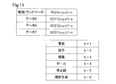
画像GP1には、路肩を示す画像D1、路肩よりも内側に引かれた道路縁を示す実線の画像D2、走行車線間に引かれた破線の画像D3、中央分離帯側の道路縁を示す実線の画像D4、路肩付近に設けられた標識の画像D5、信号の画像D6、更には、看板の画像D7等が存在する。画像解析部132はこれらの画像を解析し、図9に示すような、データを抽出する。理解の便を図って、図8と図9では、同じ符号D1~D7を用いるが、図8に示した画像は、カメラなどの画像取得部130が撮像したアナログデータ(但し2値化済みデータ)であるのに対して、図9に示した画像は解析され、抽出されたデジタルデータである。
The image GP1 includes an image D1 showing the road shoulder, an image D2 of a solid line drawn inside the road shoulder, an image D2 of a broken line drawn between the driving lanes, and a solid line showing the road edge on the median strip side. , an image D5 of a sign provided near the road shoulder, an image D6 of a traffic light, an image D7 of a signboard, and the like. The
路面に存在する区画線については、これを点列に変換している。点列は、画像を解析することで、奥行き方向の距離を演算し、自車位置特定部123により特定された自車位置の情報と合わせて、3次元のデータ(x,y,z)の集合として、デジタルデータとされている。奥行き方向の情報は、画像取得部130の地上高さや俯角などが既知であれば、路面を平面とみなすことで容易に演算することができる。もとより、地図が元々持っている勾配のデータを利用して、路面を3次元的に表わし、画像から線分を構成する各点の3次元データを求めるようにしてもよい。
The lane markings existing on the road surface are converted into point sequences. By analyzing the image, the point sequence calculates the distance in the depth direction, and together with the information on the vehicle position specified by the vehicle
画像解析部132は同時に線分が実線か破線かを解析する。このデータの一例を図10に示した。図9に示した4本の線分D1からD4を、データ1からデータ4として示した。各線分は、DLi(a,x,y,z)1-m として表わされる。ここで、iは、データの番号に対応し、aは線分の種類に対応している。線分の種類は、本実施形態では、図10の下段に示したように、
実線 :a=1
破線 :a=2
ボッツドッツ :a=3
道路縁(路肩等):a=4
ゼブラゾーン :a=5
の5種類である。なお、ボッツドッツは、米国などで用いれることのある道路に間隔を置いて埋め込まれた小さな円盤をいう。線分の種類は、更に多数種類であってもよいし、上記の一部であってもよい。
The
Solid line: a = 1
Broken line: a = 2
Botsdots: a=3
Road edge (road shoulder, etc.): a = 4
Zebra Zone: a=5
There are five types of Botsdots are small discs embedded in roads at intervals, which are sometimes used in the United States. The number of types of line segments may be more, or may be a part of the above.
データの添え字1-m は、線分を構成する各点が、1からmまで、m個存在することを示す。従って、例えば路肩を示すデータ1は、DL1(4,x,y,z)1-m として表わされる。この例では、データは固定長とし、データがなくなれば、NULLを入れるものとしたが、各データは、可変長のデータとして構成してもよい。あるいは、線分は、ドットの集合ではなく、開始点と終点とを結ぶベクトルデータとして定義してもよい。その場合には、実線であれば複数の折れ線の集合として、破線であれば複数の短い直線の集合として、それぞれ表わされる。従って、ベクトルデータであっても、線分をある程度正確に表現しようとすれば、複数のデータの集合として扱うことになるが、線分を少ない数(最小一本)の直線として近似してもよい。破線の場合は何らかのタグを付けて実線と区別するようにしてもよい。また、ベジュエ曲線やスプライン曲線などの曲線を用いて近似してもよい。
The suffix 1-m of the data indicates that there are m points, from 1 to m, that constitute the line segment. Therefore, for example,
画像取得部130が撮像した画像には、地物も含まれる。画像解析部132は、画像から、予め登録した対象物を解析して抽出する。実施形態で抽出する地物としては、図11に示したように、看板、信号、標識、ポール、停止線、横断歩道などがある。もとより、更に多数の地物を登録して抽出してもよいし、少なくてもよい。図11に示した例では、車両の通行に関与する、あるいは通行路に近接して設けられた地物をあげたが、橋梁やトンネル、料金所、サービスエリアなどの構造物や、湖沼、河川、丘陵、大木など、地表の形状や特徴物などを含んでよい。
The image captured by the image acquisition unit 130 also includes a feature. The
図9に示した3つの地物(標識、信号、看板)D5、D6、D7を、図11に、データ5、6、7として示した。各地物は、DCj(p,x,y,z)1-n として表わされる。ここで、jは、データの番号に対応し、bは地物の種類に対応している。地物の種類は、本実施形態では、図11の下段に示したように、
看板 b=1
信号 b=2
標識 b=3
ポール b=4
停止線 b=5
横断歩道 b=6
の6種類である。
The three features (marker, signal, signboard) D5, D6 and D7 shown in FIG. 9 are shown as
Signboard b=1
signal b=2
label b=3
Paul b=4
stop line b=5
pedestrian crossing b=6
There are six types of
データの添え字1-n は、地物を表わす複数のデータが、1からnまで、n個存在することを示す。例えば標識を示すデータ5は、DCJ(3,x,y,z)1-n として表わされる。線分と異なり、本実施形態では、地物のデータ形式は、地物の種類毎に予め定めている。例えば標識であれば、中心点の絶対座標、中心からの半径、などである。また、信号であれば、外径を表現する多角形の各点の絶対座標、信号の数と矢印の向きなどである。なお、データには、テキストデータを付加してもよい。テキストデータとしては、標識に数字や文字が表示されている場合には、これを文字認識したもの、看板であれば、看板の記載文字を文字認識したものなどが、含まれる。なお、画像データを直接含ませてもよい。その場合には、JPEGなどの圧縮技術を利用して、画像データを圧縮しておくことが、データ転送の負担を減らす上では望ましい。
The data suffixes 1-n indicate that there are n pieces of data representing features, from 1 to n. For example, the
上述した図7のステップT460では、図10,図11に示したデータ1から7を含む静的情報をプローブ情報として、自車位置の情報と共に、センタ150に送信する。車両からの自車位置と静的情報とを含む車両側情報の送信を受けるセンタ150の処理を図12に示した。
At step T460 in FIG. 7 described above, static
センタ150は、代表車両として設定した車両から、自車位置と静的情報とを含む車両側情報の送信を受けると、これを第2通信部151を介して受信する(ステップT500)。続いて、代表車両の自車位置から代表車両が走行している道路区間を特定する(ステップT510)。道路区間が特定できれば、その区間の地図を整備する処理を行なう(ステップT520)。地図の整備は、外部記憶装置172に保存された地図DBの対応する道路区間に、不足していたデータを補うことにより行なわれる。こうした地図の整備は、代表車両から車両側情報を受け取る度にリアルタイムで行なってもよいし、バッチ処理により、あとで、例えば車両の走行量が減って通信の負荷が少なくなる夜間などにまとめて行なうものとしてもよい。もとより、代表車両との通信や車両側情報の蓄積と、地図DBの整備を行なう装置とを分離し、地図の整備を別の装置で行なうものとしてもよい。地図の整備が行なわれると、図6に示したように、地図を構成する各道路区間について計算された区画線整備率と地物整備率とは、更新される。
When the
代表車両は、以上説明した車両前方SZの画像の取得と解析、解析によって得られた静的情報を含むプローブ情報と自車位置とを含む車両側情報の送信を行ない、センタ150は、車両側情報を受信して、地図整備処理を行なう。こうした情報の収集と通信を繰り返しているうちに、代表車両が、指定された道路区間から離脱する場合がある。この場合の処理を、図7のステップT420以下に示した。車両は自車位置を自車位置特定部123から取得し、走行している道路区間が、指定された道路区間内でないと判断すると(ステップT420:「NO」)、センタ150に対して、車両が指定された道路区間から離脱したことを送信する(ステップT480)。送信する離脱情報の一例を、図13に示した。離脱情報には、指定された道路区間から離脱した車両を示す車両IDと、値1に設定された離脱フラグFrが含まれる。その上で、車両内に保存されているフラグFpを値0にリセットし(ステップT490)、「NEXT」に抜けて、本処理ルーチンを一旦終了する。
The representative vehicle acquires and analyzes the image of the SZ in front of the vehicle described above, and transmits probe information including static information obtained by the analysis and vehicle-side information including the vehicle position. Information is received and map maintenance processing is performed. While repeating such information collection and communication, the representative vehicle may leave the designated road section. The processing in this case is shown from step T420 onward in FIG. When the vehicle acquires the vehicle position from the vehicle
代表車両からの離脱の送信を受けるセンタ150側は、割込処理として、図14に示した離脱割込処理ルーチンを実行する。この処理で、センタ150のCPU160は、まず離脱情報を受信し(ステップT600)、離脱情報に含まれていた車両IDから、離脱した車両を特定し、その車両が含まれていた道路区間を走行している1台以上の車両に関して、代表車両を更新する処理を行なう(ステップT610)。代表車両の更新は、図5に示した車両の配列から、離脱した車両(この例では車両IDがC1の車両)を除く車両の中から、新たな代表車両を設定することにより行なう。既に説明した様に、全ての車両は所定のインターバルで、自車位置をセンタ150に送信しており(図2:ステップT100からT120)、センタ150はこの情報を車両DBに保存し(図2:ステップT230)、道路区間毎に該当車両の配列を作成している(図2:ステップT330)から、この配列を参照することで、離脱した車両以外の車両を、新たな代表車両として設定することは容易である。
The
センタ150は、更新した代表車両に値1に設定したフラグFpを送信する(ステップT620)。こうすることで、代表車両が指定された道路区間から離脱すると、新たな代表車両が設定され、上述した車両側情報の送信(図7)と地図整備(図12)とが継続されることになる。この場合でも、図2のステップT340同様、代表車両は、その道路区間を走行している車両の中から、画像処理能力が高い車両、GNSS精度が高い車両の順に選択される。なお、代表車両は、1つの道路区間毎に離脱と更新とを繰り返すようにしてもよいが、走行が想定される連続する道路区間について、予め代表車両を設定しておき、この連続する道路区間から逸脱した場合にのみ、代表車両だった車両から「離脱」を送信するようにしてもよい。前者の場合は、道路区間毎に代表車両の台数を細かく設定して、地図整備を効率よく進めることができる。後者の場合には、代表車両の更新処理を頻繁に行なう必要がない。連続した道路区間について代表車両を設定する場合には、センタ150は車両から走行の際の目的地や目的地までの経路を予め取得し、それらの情報に基づいて、複数の道路区間に亘って代表車両となるように、設定すればよい。こうした目的地などに基づく代表車両の設定は、第2実施形態で詳しく説明する。車両にカーナビゲーションシステムが搭載されている場合や、自動運転が設定されている場合には、車両の目的地や目的地までの走行経路をやり取りすることは容易である。
The
以上、代表車両が離脱した場合の処理について説明したが、こうした代表車両の更新は、代表車両の離脱時のみならず、ある道路区間を走行している車両の構成に変動が生じた場合にも行なう。例えば、ある道路区間に新たな車両が進入した場合にも、代表車両の更新を行なってもよい。特に新たに加わった車両の画像処理能力やGNSS精度が高い場合などに、代表車両の更新を行なうことは有効である。もとより、各道路区間における車両の構成が変更されても、一定の期間は代表車両の設定を変更しないようにしてもよい。 In the above, the processing when the representative vehicle leaves has been described, but the update of the representative vehicle is not only performed when the representative vehicle leaves, but also when there is a change in the configuration of the vehicles traveling on a certain road section. do For example, when a new vehicle enters a certain road section, the representative vehicle may be updated. Especially when the newly added vehicle has high image processing capability and high GNSS accuracy, it is effective to update the representative vehicle. Of course, even if the configuration of vehicles in each road section is changed, the setting of the representative vehicle may not be changed for a certain period of time.
以上説明した第1実施形態の移動空間情報処理システム(地図整備システム)200は、道路を走行している車両の少なくとも1つを代表車両として設定し、車両から得られた区画線や地物のデータを含む静的情報をプローブ情報として利用し、地図DBを整備することができる。しかも、その場合に、地図における道路区間毎の地図整備の状況に基づいて、代表車両としてプローブ情報を送信する車両の数を設定し、区画線整備率や地物整備率の低い道路区間では多数の、最大全ての走行車両を代表車両に設定して、迅速に静的情報を収集して地図を整備できる。他方、地図の整備が進んでいる道路区間では、代表車両の台数を減らし、最小1台を代表車両に設定し、車両とセンタ150との通信量や、センタ150での処理量を低減できる。このため、通信量の肥大化を招くことなく、地図整備を短期間のうちに進めることができる。なお、整備率が100%の道路区間でも少なくとも1台の代表車両を設定して静的情報の送信を受けるのは、整備された道路の確認のためである。地図が一旦整備された道路区間でも、工事や災害などで、道路の状況が変化する場合があり、こうした状況の変化があれば、整備率を下げて、代表車両の数を増やし、地図の再整備を行なえばよい。なお、整備率以外に、道路利用者からの通報やドローンなどを用いた道路監視の技術などを利用して、道路の状況に変動や異常がある可能性が所定の閾値より高いと判断した場合には、代表車両の数を増やして、地図の再整備を行なうようにしてもよい。
The moving space information processing system (map maintenance system) 200 of the first embodiment described above sets at least one of the vehicles traveling on the road as a representative vehicle, and calculates the lane markings and features obtained from the vehicles. A map DB can be maintained using static information including data as probe information. Moreover, in that case, based on the map maintenance status of each road section on the map, the number of vehicles that transmit probe information as representative vehicles is set, and in road sections with low marking line maintenance rates and feature maintenance rates, a large number of vehicles are set. At most, all running vehicles can be set as representative vehicles to quickly collect static information and develop a map. On the other hand, in road sections where map development is progressing, the number of representative vehicles can be reduced and at least one vehicle can be set as the representative vehicle, thereby reducing the amount of communication between vehicles and the
上記実施形態では、代表車両以外の車両も、常に自車の位置と自車の能力を含む自車情報をセンタ150に送信しているので、代表車両の設定および更新を容易に行なうことができる。また、各車両111,112,113等は、センタ150以外とは通信しないので、通信量が増大せず、各車の行き先などを他車に知らせることがない。
In the above embodiment, vehicles other than the representative vehicle always transmit their own vehicle information including their own vehicle positions and their own vehicle capabilities to the
上記実施形態では、代表移動体である代表車両は、指定された道路区間を走行している時に、リアルタイムでプローブ情報をセンタ150に送信したが、車両側にハードディスクなどの外部記憶装置を設け、プローブ情報を道路区間と対応付けて記憶しておき、車両が無線LAN環境など、高速通信が可能な場所に来たときに、プローブ情報をまとめて送信するようにしてもよい。
In the above embodiment, the representative vehicle, which is the representative moving object, transmits probe information to the
この他、プローブ情報には、動的情報を加えることも差し支えない。また、上記の移動空間情報処理システム200は、船舶やドローンを移動体として扱うものとしてもよい。船舶では路面上の区間線は存在しないが、水路の縁や、その他の地物は存在する。運河などでは、信号も存在するため、上記の移動空間情報処理システム200と同様のシステムを利用することができる。この場合、プローブ情報に含まれる静止情報のうち、地物としては、看板、橋梁、灯台、標識、岩礁のうち少なくとも1つが含まれる。また、移動範囲制限情報には、海岸線、護岸、桟橋のうち少なくとも1つが含まれる。同様に、ドローンや小型飛行機などにも適用することができる。この場合には、プローブ情報に含まれる静止情報のうち、地物としては、地上から空中に突出する建物、鉄塔、電柱、電線、看板、標識のうち少なくとも1つが含まれる。また、移動範囲制限情報には、少なくとも飛行経路を示す誘導灯が含まれる。
In addition, dynamic information may be added to probe information. Further, the moving space
B.第2実施形態:
図15に示すように、第2実施形態の通信システム500は、通信装置100と、基地局BSと、を備える。通信装置100は、移動体MCに搭載されている。本実施形態では、移動体MCとして車両を用いるが、これに限られず、通信装置100は、例えば、船舶やドローンなどの車両以外の移動体に搭載されていてもよい。
B. Second embodiment:
As shown in FIG. 15, a
基地局BSは、通信装置100と通信可能な無線局である。基地局BSは、サーバ135を備え、サーバ135は、通信装置100と通信した情報を収集するとともに、管理する。サーバ135により管理された情報は、車両向けテレマティクスサービスや路車協調サービスや車車協調サービスに用いられる。
The base station BS is a radio station that can communicate with the
図16に示すように、移動体MCは、通信装置100のほか、移動体制御部110と、ナビゲーション装置22と、GNSSセンサ24と、を備える。移動体制御部110は、移動体MCの制御を行う機能部であり、CPUと、ROMやRAMなどのメモリと、を備える周知のコンピュータとして構成されている。移動体制御部110には、ナビゲーション装置22、GNSSセンサ24が電気的に接続されているため、これらの装置による出力結果が通知される。
As shown in FIG. 16 , the mobile MC includes a
GNSSセンサ24は、ナビゲーション装置22の現在位置を取得する。具体的には、GNSSセンサ24は、GNSS(Global Navigation Satellite System)を構成する人工衛星から受信した航法信号に基づいて、移動体MCの現在位置(経度・緯度)を測位する。
A
ナビゲーション装置22は、経路探索および経路案内を行うカーナビゲーション装置である。本実施形態のナビゲーション装置22は、移動体MCの利用者から入力を受ける図示しないインターフェースを備える。ナビゲーション装置22は、このインターフェースから目的地についての入力をされた後、ナビゲーション装置22に内蔵された地図を用いて目的地までの経路を決定した後、経路案内を行う。ナビゲーション装置22は、GNSSセンサ24と接続されており、経路案内に際してGNSSセンサ24から得られた現在位置の情報を用いる。
The navigation device 22 is a car navigation device that performs route search and route guidance. The navigation device 22 of this embodiment includes an interface (not shown) that receives input from the user of the mobile object MC. After the navigation device 22 receives an input about the destination through this interface, the navigation device 22 determines the route to the destination using the map built in the navigation device 22, and then provides route guidance. The navigation device 22 is connected to a
本実施形態の通信装置100は、移動体MCの移動体制御部110と電気的に接続されているため、通信装置100は、移動体制御部110から移動体MCの各種情報の受信が可能である。なお、通信装置100と移動体MCとの接続はこれに限られず、例えば、無線通信による接続を用いてもよい。また、通信装置100と移動体MCとは接続されておらず、通信装置100が、ナビゲーション装置22やGNSSセンサ24を別途備えてもよい。
Since the
通信装置100は、基地局BSや他の通信装置と通信可能な機器である。また、通信装置100は、機能部として、自己情報取得部11と、他者情報取得部12と、判定部13と、移動体群設定部14と、代表設定部16と、送信部17を備える。通信装置100は、CPUと、ROMやRAMなどのメモリと、を備える周知のコンピュータとして構成されており、ROMに記憶されている所定のプログラムを実行することにより各部の機能を実現する。
A
以下、本実施形態における通信装置100の通信処理について説明する。通信装置100は、まず、通信装置100を搭載する移動体MCが移動体群に加入する加入処理を行う。加入処理は、通信装置100を搭載する移動体MCが移動体群に加入していない場合に定期的(例えば、5分間隔)に行われる。
Communication processing of the
図17に示すように、加入処理として、まず、通信装置100は、搭載された自己の移動体の目的地の情報を含む自己情報を取得する(工程S110)。工程S110における通信装置100の機能部は、自己情報取得部11である。本実施形態では、通信装置100は、目的地の情報と、移動体MCの固有情報とを取得する。ここで、目的地の情報は、移動体制御部110を介してナビゲーション装置22から取得される。移動体MCの固有情報は、予め移動体制御部110に記憶されており、移動体制御部110から取得される。
As shown in FIG. 17, as the joining process, first, the
次に、通信装置100は、周辺(例えば、100m以内)に位置する他の移動体の目的地を含む他者情報を取得する(工程S120)。工程S120における通信装置100の機能部は、他者情報取得部12である。本実施形態では、通信装置100は、通信装置100に内蔵された通信機能を用いて、他者情報として、他の移動体の目的地の情報と、他の移動体の固有情報とを取得する。具体的には、通信装置100が周辺に位置する他の通信装置に対して他者情報の送信要求を行ない、この要求に対して、周辺に位置する他の通信装置が通信装置100に対して他者情報を送信することにより、通信装置100は他者情報を取得する。ここで、目的地の情報は、自己情報の場合と同様に、他者の移動体制御部を介してナビゲーション装置から取得される。他者の移動体の固有情報についても、自己情報の場合と同様に、予め他者の移動体制御部に記憶されており、他者の移動体制御部から取得される。
Next, the
次に、通信装置100は、自己情報と他者情報とを用いて、自己の移動体MCの目的地と同じ方向の目的地である他の移動体が存在するかどうかを判定する(工程S130)。工程S130における通信装置100の機能部は、判定部13である。本実施形態では、「自己の移動体MCの目的地と同じ方向の目的地」とは、自己の移動体MCの目的地が含まれる都道府県と同じ都道府県に含まれる目的地をいう。
Next, the
図18は、工程S130を説明するための図であり、図18には、複数の移動体と移動体ごとの目的地が記載されている。そして、図18において、紙面において最も下側の移動体が自己の移動体MCとし、自己の移動体以外の他の移動体を、紙面において下から順に移動体MC1からMC6とする。この場合、通信装置100は、自己の移動体MCの目的地が含まれる都道府県は○○県である。そして、周囲に位置する他の移動体の中で、目的地が含まれる都道府県が○○県である移動体は、移動体MC1~MC3、MC5~MC6である。一方、移動体MC4は、目的地が含まれる都道府県は△△県である。
FIG. 18 is a diagram for explaining step S130, and FIG. 18 describes a plurality of moving bodies and destinations for each of the moving bodies. In FIG. 18, the lowermost moving body on the paper surface is the self-moving body MC, and the moving bodies other than the self-moving body are the moving bodies MC1 to MC6 in order from the bottom on the paper surface. In this case, the prefecture including the destination of the mobile unit MC of the
自己の移動体MCの目的地と同じ方向の目的地である他の移動体が存在すると判定した場合(工程S130:YES)、通信装置100は、自己の移動体MCと同じ目的地と同じ方向の目的地である他の移動体と、自己の移動体が同じ移動体群に属することとなるように設定し(工程S140)、フローを終了する。工程S140における通信装置100の機能部は、移動体群設定部14である。図18では、予め、自己の移動体MCと同じ目的地と同じ方向の目的地である他の複数の移動体MC1~MC3、MC5~MC6は、移動体群Hを形成している。このため、図18の紙面右側に示すように、自己の移動体MCは、移動体群Hに属することとなるように設定する。本実施形態では、移動体群に含まれる移動体は、移動体群への加入の際に、予め、移動体群に含まれる移動体の固有情報を共有しているとし、自己の移動体MCは、移動体群Hを構成する他の移動体群に自己の固有情報を報知することにより、移動体群Hに属することとなる。なお、自己の移動体MCと同じ目的地と同じ方向の目的地である他の移動体は、予め移動体群を形成していなくてもよい。つまり、移動体MCの周囲に移動体群が存在しない場合であっても、移動体MCの周囲において、自己の移動体MCと同じ目的地と同じ方向の目的地である他の移動体が存在する場合は、その移動体と自己の移動体MCとが移動体群を形成する。
When it is determined that there is another mobile body whose destination is in the same direction as the destination of the mobile body MC of itself (step S130: YES), the
一方、自己の移動体MCの目的地と同じ方向の目的地である他の移動体が存在しないと判定した場合(工程S130:YES)、通信装置100は、移動体群への加入は行わず、フローを終了する。この加入処理は、自己の移動体が特定の移動体群へ加入するまで所定の間隔(例えば、1分)をおいて繰り返し行われる。
On the other hand, if it is determined that there is no other mobile unit whose destination is in the same direction as the destination of the mobile unit MC itself (step S130: YES), the
通信装置100は、自己の移動体MCが加入処理を行った後、移動体群の中から代表の移動体を設定する代表設定処理を行う。代表設定処理における通信装置100の機能部は、代表設定部16である。通信装置100は、通信装置100が搭載されている移動体MCが含まれる移動体群の中から、移動体群を代表する代表移動体を設定する。
After the own mobile unit MC has performed the joining process, the
本実施形態では、代表の設定は、新たに移動体群に加入した通信装置100が行う。しかし、これに限られず、代表の設定は、通信装置100が搭載された移動体MCが移動体群に加入するときに代表移動体に設定された移動体により行なわれてもよい。なお、自己の移動体MCと他の移動体とが新たに移動体群を形成する場合、両方の移動体に搭載された通信装置100が並行して代表の設定を行う。
In this embodiment, the setting of the representative is performed by the
本実施形態では、通信装置100は、自己情報と他者情報とを処理する能力の大小に従って代表の移動体を設定する。具体的には、通信装置100は、移動体群を構成する移動体の中で、最も余剰処理能力が高い移動体を代表に設定する。本実施形態において、余剰処理能力が高い移動体とは、移動体の移動体制御部110を構成するCPUの処理性能が最も高いものであって、移動体制御部110を構成するメモリの空き容量が最も多いものをいう。ここで、CPUの処理性能とは、動作周波数とIPC(Instructions Per Clock cycle)との積とする。しかし、これに限られず、例えば、通信装置100は、移動体群を構成する移動体のうち、現在位置から目的地までの距離が最も遠い移動体を代表に設定してもよい。また、通信装置100は、移動体群を構成する移動体のうち、最後に移動体群に加入した移動体を代表移動体に設定してもよい。このようにすることにより、代表移動体の設定方法を簡略化することができる。最後に移動体群に加入した移動体を代表移動体に設定する場合であって、自己の移動体MCと他の移動体とが新たに移動体群を形成する場合、現在位置から目的地までの距離が最も遠い移動体を代表に設定してもよい。
In this embodiment, the
代表の設定後、通信装置100は、移動体群を構成する他の移動体へ代表となった移動体の固有情報を送信し、代表設定処理は終了する。
After setting the representative, the
代表が設定された後、通信装置100は、通信処理を行う。通信処理における通信装置100の機能部は、送信部17である。具体的には、図19に示すように、まず、通信装置100は、自己の移動体MCが代表かどうかを判定する(工程S200)。自己の移動体MCが代表と判定した場合(工程S200:YES)、通信装置100は、自己の移動体MCが所属する移動体群を構成する他の移動体から基地局に送信するための移動体情報を収集した後(工程S210)、基地局へ収集した情報を送信し(工程S220)、フローは終了する。本実施形態では、移動体情報としては、移動体群を構成する移動体ごとの固有情報と目的地の情報が含まれる。
After the representative is set, the
一方、自己の移動体MCが代表に設定されていない場合(工程S200:NO)、通信装置100は、自己情報を代表に設定された移動体に送信した後(工程S230)、フローは終了する。
On the other hand, if the own mobile body MC is not set as the representative (step S200: NO), the
本実施形態では、通信処理は、所定間隔(例えば、10秒間)を置いて繰り返し行われる。本実施形態では、通信処理において基地局BSに送信された情報は、車両向けテレマティクスサービスや路車協調サービスや車車協調サービスに用いられる。 In this embodiment, the communication process is repeatedly performed at predetermined intervals (for example, 10 seconds). In this embodiment, the information transmitted to the base station BS in the communication process is used for the telematics service for vehicles, road-vehicle cooperation service, and vehicle-to-vehicle cooperation service.
本実施形態の通信装置100によれば、自己情報と他者情報とを用いて、目的地が同じ方向の目的地である他の移動体と自己の移動体MCとを同じ移動体群Hとすることができる。この結果として、移動体群Hを構成する移動体の目的地が互いに近いほど、移動体群Hから抜ける移動体を低減できることによって、移動体群を編成する際の処理を低減する結果、基地局BSに情報を送信するための処理負荷を低減できる。
According to the
また、本実施形態では、通信装置100の代表設定部16は、移動体群を構成する移動体の中で、最も余剰処理能力が高い移動体を代表の移動体に設定する。このようにすることにより、最も余剰処理能力が高い移動体が基地局への情報送信を行うため、基地局への情報送信を円滑に行うことができる。
Further, in the present embodiment, the
C.他の実施形態
C1.他の実施形態1
上述の実施形態では、「自己の移動体MCの目的地と同じ方向の目的地」は、自己の移動体MCの目的地が含まれる都道府県と同じ都道府県に含まれる目的地をいう。しかし、これに限られない。例えば、「自己の移動体MCの目的地と同じ方向の目的地」は、予め定められた時間(例えば、10分後)後に到達予定の地点が予め定められた範囲(例えば、半径1キロメートル)以内であることとしてもよい。つまり、移動体群設定部14は、自己情報と他者情報を用いて、予め定められた時間後に到達予定の地点が予め定められた範囲以内である場合に、目的地が同じ方向であると判断してもよい。このようにすることにより、予め定められた時間後まで移動体群から抜ける移動体を低減できる。
C. Other Embodiments C1.
In the above-described embodiment, the "destination in the same direction as the destination of one's mobile body MC" refers to a destination included in the same prefecture as the destination of one's mobile body MC. However, it is not limited to this. For example, "destination in the same direction as the destination of own mobile object MC" is a predetermined range (for example, a radius of 1 kilometer) of a point to be reached after a predetermined time (for example, 10 minutes later). It may be within In other words, the moving body
また、「自己の移動体MCの目的地と同じ方向の目的地」は、自己の移動体MCの目的地に通過すべき経路と同じ経路としてもよい。図20に示すように、移動体群を、国道○号を目指す移動体で構成された移動体群H1と、県道△号を目指す移動体で構成された移動体群H2とに設定してもよい。 Also, the "destination in the same direction as the destination of the own mobile body MC" may be the same route as the route through which the own mobile body MC should pass to the destination. As shown in FIG. 20, even if the moving object group is set to a moving object group H1 composed of moving objects aiming at national highway No. XX and a moving object group H2 composed of moving objects aiming at prefectural road No. △, good.
また、「自己の移動体MCの目的地と同じ方向の目的地」は、例えば、現在地から他の移動体の目的地までの方向が、現在地から自己の移動体MCの目的地までの方向に対して±10°以内であるとしてもよい。このようにすることにより、自己の移動体の目的地と他の移動体の目的地が遠い場合においても途中までの道のりが同じ移動体同士を同じ移動体群とすることができる。このため、移動体群への移動体から抜ける移動体を低減できる。 Also, the "destination in the same direction as the destination of one's mobile body MC" means, for example, that the direction from the current location to the destination of another mobile body is the direction from the current location to the destination of one's mobile body MC. may be within ±10°. By doing so, even when the destination of the own mobile body is far from the destination of another mobile body, the mobile bodies having the same distance to the middle can be included in the same mobile body group. Therefore, it is possible to reduce the number of moving bodies that escape from the moving body group.
C2.他の実施形態2
上述の実施形態では、余剰処理能力が高い移動体として、移動体の移動体制御部110を構成するCPUの処理性能が最も高いものであって、移動体制御部110を構成するメモリの空き容量が最も多いものとしたが、これに限られない。例えば、図21に示す方法により、余剰処理能力が高い移動体を選定してもよい。
C2.
In the above-described embodiment, as a mobile body with a high surplus processing capacity, the processing performance of the CPU configuring the mobile
具体的には、まず、通信装置100は、移動体の移動体制御部110を構成するCPUの処理性能が最も高いものを抽出する(工程S310)。その後、通信装置100は、移動体の移動体制御部110を構成するメモリの空き容量が最大のものを抽出する(工程S320)。そして、通信装置100は、その移動体のメモリの空き容量が予め定められた閾値Ct(例えば、全メモリの10%)以上かどうかを判定する(工程S330)。その移動体のメモリの空き容量が予め定められた閾値Ct以上である場合(工程S330:YES)、通信装置100は、その移動体を代表の移動体に設定して(工程S340)、フローは終了する。
Specifically, first, the
一方、その移動体のメモリの空き容量が閾値Ct未満である場合(工程S330:YNO)、通信装置100は、工程S310にて抽出された移動体を除外する(工程S350)。そして、通信装置100は、工程S350により除外されていない移動体が存在する場合(工程S360:YES)、工程S310に戻る。つまり、通信装置100は、処理性能が最高の移動体を除外し、工程S310において、それ以外の移動体の中で処理性能が最高のものを抽出する。一方、工程S350により除外されていない移動体が存在しない場合(工程S360:NO)、通信装置100は、移動体の移動体制御部110を構成するCPUの処理性能が最も高いものを抽出した後(工程S370)、移動体の移動体制御部110を構成するメモリの空き容量が最大のものを抽出する(工程S380)。そして、通信装置100は、その移動体を代表に設定する(S340)。このようにすることにより、メモリの空き容量が閾値Ct以上である移動体が移動体群に存在する場合には最もCPUの処理性能が高い移動体を代表の移動体とすることができる。
On the other hand, if the free memory space of the mobile object is less than the threshold Ct (step S330: YNO), the
C3.他の実施形態3
上述の実施形態では、移動体として車両を用いているが、例えば、図22に示すように移動体としてドローンを用いてもよい。また、図22に示すように、「自己の移動体MCの目的地と同じ方向の目的地」として、自己の移動体MCの目的地が含まれる市町村と同じ市町村に含まれる目的地としてもよい。図22では、移動体群を、○○市を目指す移動体で構成された移動体群H3と、××市を目指す移動体で構成された移動体群H4とに設定している。
C3.
In the above-described embodiment, a vehicle is used as the mobile body, but a drone may be used as the mobile body, as shown in FIG. 22, for example. Further, as shown in FIG. 22, the "destination in the same direction as the destination of the own mobile body MC" may be a destination included in the same municipality as the destination of the own mobile body MC. . In FIG. 22, the moving body group is set to a moving body group H3 composed of moving bodies aiming for XX city and a moving body group H4 composed of moving bodies aiming for XX city.
上記各実施形態において、ハードウェアによって実現されていた構成の一部をソフトウェアに置き換えるようにしてもよい。ソフトウェアによって実現されていた構成の少なくとも一部は、ディスクリートな回路構成により実現することも可能である。また、本開示の機能の一部または全部がソフトウェアで実現される場合には、そのソフトウェア(コンピュータプログラム)は、コンピュータ読み取り可能な記録媒体に格納された形で提供することができる。「コンピュータ読み取り可能な記録媒体」とは、フレキシブルディスクやCD-ROMのような携帯型の記録媒体に限らず、各種のRAMやROM等のコンピュータ内の内部記憶装置や、ハードディスク等のコンピュータに固定されている外部記憶装置も含んでいる。すなわち、「コンピュータ読み取り可能な記録媒体」とは、データパケットを一時的ではなく固定可能な任意の記録媒体を含む広い意味を有している。 In each of the above embodiments, part of the configuration implemented by hardware may be replaced with software. At least part of the configuration implemented by software can also be implemented by a discrete circuit configuration. In addition, when part or all of the functions of the present disclosure are realized by software, the software (computer program) can be provided in a form stored in a computer-readable recording medium. "Computer-readable recording medium" means not only portable recording media such as flexible disks and CD-ROMs, but also various internal storage devices such as RAM and ROM, and fixed to computers such as hard disks. It also includes an external storage device. That is, the term "computer-readable recording medium" has a broad meaning including any recording medium capable of fixing data packets instead of being temporary.
本開示は、上述の実施形態に限られるものではなく、その趣旨を逸脱しない範囲において種々の構成で実現することができる。例えば、発明の概要の欄に記載した各形態中の技術的特徴に対応する実施形態中の技術的特徴は、上述の課題の一部又は全部を解決するために、あるいは、上述の効果の一部又は全部を達成するために、適宜、差し替えや、組み合わせを行うことが可能である。また、その技術的特徴が本明細書中に必須なものとして説明されていなければ、適宜、削除することが可能である。 The present disclosure is not limited to the embodiments described above, and can be implemented in various configurations without departing from the scope of the present disclosure. For example, the technical features in the embodiments corresponding to the technical features in the respective modes described in the Summary of the Invention column may be used to solve some or all of the above problems, or Substitutions and combinations may be made as appropriate to achieve part or all. Also, if the technical features are not described as essential in this specification, they can be deleted as appropriate.
11…自己情報取得部、12…他者情報取得部、13…判定部、14…移動体群設定部、16…代表設定部、17…送信部、22…ナビゲーション装置、24…GNSSセンサ、100…通信装置、110…移動体制御部、111,112,113…車両、120…移動体制御装置、121…第1通信部、122…GNSS処理部、123…自車位置特定部、124…アンテナ、130…画像取得部、132…画像解析部、135…サーバ、140…制御部、150…情報処理装置(センタ)、151…第2通信部、154…アンテナ、160…CPU、161…特定部、162…移動体把握部、170…メモリ、171,172…外部記憶装置、200…移動空間情報処理システム(地図整備システム)、BS…基地局、H、H1~H4…移動体群、MC、MC1~MC6…移動体
REFERENCE SIGNS
Claims (14)
空間を移動する移動体(111,112,113)と、前記移動体との間で情報をやり取りして前記空間に関する情報である空間情報を整備する情報処理装置(150)と、を備え、
前記移動体は、
少なくとも前記空間における当該移動体の位置の情報を含む移動体側情報を、通信により、前記情報処理装置とやり取りする第1通信部(121)と、
当該移動体が移動している空間の画像を取得する画像取得部(130)と、
前記情報処理装置により代表移動体(112)として設定された場合、前記取得した画像から前記空間に関するプローブ情報を抽出し、前記プローブ情報を含む前記移動体側情報を、前記情報処理装置に送信する制御部(140)と、
を備え、
前記情報処理装置は、
前記移動体と通信を行なう第2通信部(151)と、
前記通信を用いて、前記移動体側情報を取得し、前記移動体側情報に含まれる前記位置の情報に従って、前記空間内の予め定めた移動範囲を移動している移動体を把握する移動体把握部(162)と、
前記移動範囲を移動している移動体の中から、少なくとも1台の移動体を代表移動体として特定し、前記特定された移動体に対して代表移動体としての設定を行なう特定部(161)と、
前記代表移動体から、前記プローブ情報を受け取り、前記プローブ情報を用いて、前記空間情報を整備する整備部(163)と
を備え、
前記情報処理装置の前記特定部は、前記移動範囲を移動している前記移動体のうち、前記代表移動体として設定する移動体の割合を、前記移動範囲に対応した前記空間情報の前記整備の度合いに応じて決定する、移動空間情報処理システム。 A mobile space information processing system (200),
A moving body (111, 112, 113) that moves in space, and an information processing device (150) that exchanges information with the moving body and organizes spatial information that is information about the space,
The moving body is
a first communication unit (121) for exchanging mobile-side information including at least information on the position of the mobile body in the space with the information processing device through communication;
an image acquisition unit (130) for acquiring an image of the space in which the moving body is moving;
Control for extracting probe information related to the space from the acquired image when the information processing device sets the representative mobile body (112), and transmitting the mobile body side information including the probe information to the information processing device. a unit (140);
with
The information processing device is
a second communication unit (151) that communicates with the mobile body;
A moving object grasping unit that obtains the moving object side information using the communication, and grasps a moving object that is moving within a predetermined movement range in the space according to the position information included in the moving object side information. (162) and
A specifying unit (161) for specifying at least one moving body as a representative moving body from among the moving bodies moving in the movement range and setting the specified moving body as the representative moving body. When,
a maintenance unit (163) that receives the probe information from the representative mobile body and maintains the spatial information using the probe information;
The specifying unit of the information processing device determines a ratio of the moving bodies set as the representative moving body among the moving bodies moving within the moving range in the maintenance of the spatial information corresponding to the moving range. A moving space information processing system that makes decisions according to the degree.
前記特定部は、
前記移動範囲の前記空間情報の少なくとも一部が存在しない場合には、前記移動範囲の前記移動体のうち、前記通信が可能な移動体を前記代表移動体として設定し、
前記移動範囲の前記空間情報の少なくとも一部の確度が予め定めた第1閾値未満の場合には、前記移動範囲の前記移動体のうち前記代表移動体として設定される移動体の割合が予め定めた割合となるように、前記代表移動体を設定し、
前記移動範囲の前記空間情報の確度が前記第1閾値より大きな第2閾値以上の場合には、前記移動範囲の前記移動体のうち前記代表移動体として設定される移動体の数を1とするように設定する
移動空間情報処理システム。 The mobile space information processing system according to claim 1,
The identification unit
if at least part of the spatial information of the movement range does not exist, setting the mobile body capable of communication among the mobile bodies within the movement range as the representative mobile body;
When the accuracy of at least part of the spatial information of the movement range is less than a predetermined first threshold, a proportion of the moving bodies set as the representative moving bodies among the moving bodies within the movement range is predetermined. setting the representative moving body so that the ratio is
When the accuracy of the spatial information in the moving range is equal to or greater than a second threshold larger than the first threshold, the number of moving bodies set as the representative moving bodies among the moving bodies in the moving range is set to 1. Mobile space information processing system.
前記情報処理装置の前記特定部は、前記移動範囲を移動している移動体のうち、
(条件1)前記移動体が前記取得した画像から前記プローブ情報を抽出する能力に相対的な差がある複数の移動体では、相対的に前記能力の高い移動体を、前記能力が低い移動体よりも、
(条件2)前記移動体が前記移動体側情報に含ませる前記移動体の位置の情報の精度に相対的な差がある複数の移動体では、相対的に前記精度の高い移動体を、前記精度が低い移動体よりも、
前記代表移動体として選択しやすくする、移動空間情報処理システム。 The mobile space information processing system according to claim 1 or claim 2,
The identifying unit of the information processing device, among moving objects moving in the movement range,
(Condition 1) In a plurality of moving bodies having relative differences in ability to extract the probe information from the acquired image, moving bodies having relatively high ability are replaced with moving bodies having low ability. than,
(Condition 2) For a plurality of moving bodies having relative differences in the accuracy of information on the position of the moving body to be included in the moving body side information, the moving body with the relatively high accuracy is than mobile objects with low
A mobile space information processing system that facilitates selection as the representative mobile body.
定を再度行なう請求項1から請求項4のいずれか一項に記載の移動空間情報処理システム。 The identifying unit of the information processing device determines that the configuration of the plurality of moving bodies that move within the movement range has changed after the setting of representative moving bodies for the plurality of moving bodies that move within the movement range has been performed. 5. The mobile space information processing system according to any one of claims 1 to 4, wherein said setting of said representative mobile body is performed again if said representative mobile body is set.
(A)前記移動体が移動する前記空間に存在する地物の情報、
(B)前記移動体が移動する前記空間の移動範囲に係わる情報を示す移動範囲制限情報、
のうちの少なくとも一方を含み、更に、
(C)前記移動体の位置情報
を含む、請求項1から請求項5のいずれか一項に記載の移動空間情報処理システム。 In the probe information, as static information that is fixed information in the space,
(A) information on features existing in the space in which the moving object moves;
(B) movement range restriction information indicating information related to the movement range of the space in which the moving object moves;
and at least one of
6. The mobile space information processing system according to any one of claims 1 to 5, further comprising (C) positional information of said mobile body.
前記プローブ情報に含まれる静止情報のうち、前記地物には、地上に存在する看板、信号機、標識、ポール、停止線、横断歩道のうち少なくとも1つが含まれ、
前記移動範囲制限情報には、地上に引かれた実線、破線、ボッツドッツ、道路縁のうち少なくとも1つが含まれる、請求項6に記載の移動空間情報処理システム。 The moving object is a vehicle that travels on a road surface,
Among the stationary information included in the probe information, the features include at least one of signboards, traffic lights, signs, poles, stop lines, and pedestrian crossings existing on the ground,
7. The mobile space information processing system according to claim 6, wherein said movement range restriction information includes at least one of solid lines, dashed lines, bots dots, and road edges drawn on the ground.
前記プローブ情報に含まれる静止情報のうち、前記地物には、地上から前記空中に突出する建物、鉄塔、電柱、電線、看板、標識のうち少なくとも1つが含まれ、
前記移動範囲制限情報には、少なくとも飛行経路を示す誘導灯が含まれる、請求項6に記載の移動空間情報処理システム。 The mobile body is a drone that moves in the air,
Among the static information included in the probe information, the feature includes at least one of a building, a steel tower, a utility pole, an electric wire, a signboard, and a sign projecting from the ground into the air,
7. The mobile space information processing system according to claim 6, wherein said movement range restriction information includes at least a guide light indicating a flight route.
前記プローブ情報に含まれる静止情報のうち、前記地物には、看板、橋梁、灯台、標識、岩礁のうち少なくとも1つが含まれ、
前記移動範囲制限情報には、海岸線、護岸、桟橋のうち少なくとも1つが含まれる、請求項6に記載の移動空間情報処理システム。 The mobile body is a ship that moves on the water surface,
Among the static information included in the probe information, the feature includes at least one of a signboard, a bridge, a lighthouse, a sign, and a reef,
7. The mobile space information processing system according to claim 6, wherein said movement range restriction information includes at least one of a coastline, a seawall, and a pier.
前記移動体は、少なくとも前記空間における当該移動体の位置の情報を含む移動体側情報を、通信により出力し、
予め記憶したプログラムをコンピュータが実行することで情報を処理する情報処理装置が、前記移動体から通信により前記移動体側情報を取得し、前記移動体側情報に含まれる前記位置の情報に従って、前記空間内の予め定めた移動範囲を移動している移動体の中から、少なくとも1台の移動体を代表移動体として特定し、前記特定された移動体に対して代表移動体としての設定を行ない、
前記情報処理装置が、前記移動範囲を移動している前記移動体のうち、前記代表移動体として設定する移動体の割合を、前記移動範囲に対応した前記空間情報の前記整備の度合いに応じて決定し、
前記代表移動体に設定された前記移動体は、当該移動体が移動している空間の画像を取得し、当該画像から前記空間に関するプローブ情報を抽出し、前記プローブ情報を含む前記移動体側情報を送信し、
前記情報処理装置は、前記代表移動体から受け取った前記プローブ情報を用いて、前記空間情報を整備する、
移動空間情報処理方法。 A moving space information processing method for exchanging information with a moving body moving in space to organize space information, which is information about the space,
the mobile body outputs mobile-side information including at least position information of the mobile body in the space through communication;
An information processing device that processes information by having a computer execute a pre-stored program acquires the mobile body side information from the mobile body through communication, and moves within the space according to the position information included in the mobile body side information. identifying at least one moving body as a representative moving body from among the moving bodies moving within a predetermined moving range of (1), and setting the identified moving body as a representative moving body;
The information processing device determines a ratio of moving bodies to be set as the representative moving body among the moving bodies moving within the moving range according to the degree of preparation of the spatial information corresponding to the moving range. decide and
The moving body set as the representative moving body acquires an image of the space in which the moving body is moving, extracts probe information related to the space from the image, and obtains the moving body side information including the probe information. send and
The information processing device organizes the spatial information using the probe information received from the representative mobile body.
Moving space information processing method.
搭載された自己の移動体の目的地を含む自己情報を取得する自己情報取得部(11)と、
周辺に位置する他の移動体の目的地を含む他者情報を取得する他者情報取得部(12)と、
前記自己情報と前記他者情報とを用いて、前記自己の移動体の目的地と同じ方向の目的地である他の移動体と、前記自己の移動体が同じ移動体群となるように設定する移動体群設定部(14)と、
前記移動体群の中から代表の移動体を設定する代表設定部(16)と、
前記自己の移動体が前記代表の移動体に設定された場合に、前記移動体群を構成する移動体の情報を基地局へ送信する送信部(17)と、を備える、通信装置。 A communication device (100) mounted on a mobile object,
a self-information acquisition unit (11) for acquiring self-information including the destination of the self-mounted mobile body;
a third party information acquisition unit (12) that acquires other party information including destinations of other moving bodies located in the vicinity;
By using the self information and the other person's information, setting is made so that the self moving body and another moving body having a destination in the same direction as the destination of the self moving body belong to the same moving body group. a moving body group setting unit (14) for
a representative setting unit (16) for setting a representative moving object from the group of moving objects;
and a transmitting unit (17) for transmitting information on mobiles constituting the mobile group to a base station when the mobile unit of the self is set as the representative mobile unit.
前記代表設定部は、前記移動体群を構成する移動体の中で、前記自己情報と前記他者情報とを処理する能力の大小に従って前記代表の移動体を設定する、通信装置。 12. A communication device according to claim 11, wherein
The communication device, wherein the representative setting unit sets the representative mobile object according to the level of ability to process the self information and the other person's information among the mobile objects constituting the mobile object group.
前記代表設定部は、最も余剰処理能力が高い移動体を前記代表の移動体に設定する、通信装置。 13. A communication device according to claim 12,
The communication device, wherein the representative setting unit sets a mobile unit having the highest surplus processing capacity as the representative mobile unit.
前記移動体群設定部は、前記自己情報と前記他者情報を用いて、予め定められた時間後に到達予定の地点が予め定められた範囲以内である場合に前記目的地が同じ方向であると判断する、通信装置。 The communication device according to any one of claims 11 to 13,
The moving body group setting unit uses the self information and the other information to determine that the destination is in the same direction when a point to be reached after a predetermined time is within a predetermined range. A communication device that judges.
Priority Applications (2)
| Application Number | Priority Date | Filing Date | Title |
|---|---|---|---|
| PCT/JP2019/029859 WO2020027142A1 (en) | 2018-08-03 | 2019-07-30 | Movement space information processing system, movement space information processing method, and communication device |
| US17/165,323 US11893897B2 (en) | 2018-08-03 | 2021-02-02 | Movement space information processing system, movement space information processing method, and communication device |
Applications Claiming Priority (2)
| Application Number | Priority Date | Filing Date | Title |
|---|---|---|---|
| JP2018146358 | 2018-08-03 | ||
| JP2018146358 | 2018-08-03 |
Publications (3)
| Publication Number | Publication Date |
|---|---|
| JP2020024693A JP2020024693A (en) | 2020-02-13 |
| JP2020024693A5 JP2020024693A5 (en) | 2021-01-28 |
| JP7157018B2 true JP7157018B2 (en) | 2022-10-19 |
Family
ID=69618785
Family Applications (1)
| Application Number | Title | Priority Date | Filing Date |
|---|---|---|---|
| JP2019138607A Active JP7157018B2 (en) | 2018-08-03 | 2019-07-29 | Mobile space information processing system, mobile space information processing method, and communication device |
Country Status (2)
| Country | Link |
|---|---|
| US (1) | US11893897B2 (en) |
| JP (1) | JP7157018B2 (en) |
Families Citing this family (2)
| Publication number | Priority date | Publication date | Assignee | Title |
|---|---|---|---|---|
| JP7157018B2 (en) * | 2018-08-03 | 2022-10-19 | 株式会社Soken | Mobile space information processing system, mobile space information processing method, and communication device |
| CN114339681A (en) * | 2022-03-10 | 2022-04-12 | 国汽智控(北京)科技有限公司 | Cloud vehicle road cooperative processing method, system, equipment and storage medium |
Citations (6)
| Publication number | Priority date | Publication date | Assignee | Title |
|---|---|---|---|---|
| JP2008027011A (en) | 2006-07-19 | 2008-02-07 | Nec Corp | Probe information collection system, its collection device, collection method, and program |
| JP2012089088A (en) | 2010-10-22 | 2012-05-10 | Toyota Motor Corp | Probe information system and probe information processing method |
| JP2012133726A (en) | 2010-12-24 | 2012-07-12 | Nissan Motor Co Ltd | Onboard communication device and communication method |
| JP2012155660A (en) | 2011-01-28 | 2012-08-16 | Denso Corp | Map data generation device and travel support device |
| JP2012173979A (en) | 2011-02-21 | 2012-09-10 | Renesas Electronics Corp | Probe data collection system and operation method for probe data collection system |
| WO2018131153A1 (en) | 2017-01-16 | 2018-07-19 | 株式会社日立製作所 | Moving body control device and moving body control method |
Family Cites Families (16)
| Publication number | Priority date | Publication date | Assignee | Title |
|---|---|---|---|---|
| JPH11155182A (en) | 1997-11-21 | 1999-06-08 | Shingo Kojima | Loudspeaker system |
| JP2001283373A (en) | 2000-03-30 | 2001-10-12 | Toshiba Corp | Traffic flow measuring system |
| US8565860B2 (en) * | 2000-08-21 | 2013-10-22 | Biosensors International Group, Ltd. | Radioactive emission detector equipped with a position tracking system |
| JP4177422B1 (en) * | 2007-06-27 | 2008-11-05 | 本田技研工業株式会社 | Navigation server |
| WO2009026161A1 (en) * | 2007-08-16 | 2009-02-26 | Google Inc. | Combining road and vehicle sensor traffic information |
| JP2009182940A (en) * | 2008-02-01 | 2009-08-13 | Fuji Heavy Ind Ltd | Probe information system |
| US8811977B2 (en) * | 2010-05-06 | 2014-08-19 | At&T Mobility Ii Llc | Device-driven intelligence and feedback for performance optimization and planning of a service network |
| US20130201316A1 (en) * | 2012-01-09 | 2013-08-08 | May Patents Ltd. | System and method for server based control |
| US9702762B2 (en) * | 2013-03-15 | 2017-07-11 | Lightlab Imaging, Inc. | Calibration and image processing devices, methods, and systems |
| CN111351494A (en) | 2015-02-10 | 2020-06-30 | 御眼视觉技术有限公司 | Navigation system and computer readable medium |
| US10129853B2 (en) * | 2016-06-08 | 2018-11-13 | Cognitive Systems Corp. | Operating a motion detection channel in a wireless communication network |
| US10801860B2 (en) * | 2017-06-14 | 2020-10-13 | Here Global B.V. | Mapping system and method for identifying a parking lot from probe data |
| RU2734643C1 (en) * | 2017-07-07 | 2020-10-21 | Ниссан Мотор Ко., Лтд. | Parking assistance method for parking assistance device and parking assistance device |
| US20200294401A1 (en) * | 2017-09-04 | 2020-09-17 | Nng Software Developing And Commercial Llc. | A Method and Apparatus for Collecting and Using Sensor Data from a Vehicle |
| JP7157018B2 (en) * | 2018-08-03 | 2022-10-19 | 株式会社Soken | Mobile space information processing system, mobile space information processing method, and communication device |
| JP6928917B2 (en) * | 2018-11-06 | 2021-09-01 | パナソニックIpマネジメント株式会社 | Mobile management system, mobile, management device, control method, and program |
-
2019
- 2019-07-29 JP JP2019138607A patent/JP7157018B2/en active Active
-
2021
- 2021-02-02 US US17/165,323 patent/US11893897B2/en active Active
Patent Citations (6)
| Publication number | Priority date | Publication date | Assignee | Title |
|---|---|---|---|---|
| JP2008027011A (en) | 2006-07-19 | 2008-02-07 | Nec Corp | Probe information collection system, its collection device, collection method, and program |
| JP2012089088A (en) | 2010-10-22 | 2012-05-10 | Toyota Motor Corp | Probe information system and probe information processing method |
| JP2012133726A (en) | 2010-12-24 | 2012-07-12 | Nissan Motor Co Ltd | Onboard communication device and communication method |
| JP2012155660A (en) | 2011-01-28 | 2012-08-16 | Denso Corp | Map data generation device and travel support device |
| JP2012173979A (en) | 2011-02-21 | 2012-09-10 | Renesas Electronics Corp | Probe data collection system and operation method for probe data collection system |
| WO2018131153A1 (en) | 2017-01-16 | 2018-07-19 | 株式会社日立製作所 | Moving body control device and moving body control method |
Also Published As
| Publication number | Publication date |
|---|---|
| US20210225183A1 (en) | 2021-07-22 |
| JP2020024693A (en) | 2020-02-13 |
| US11893897B2 (en) | 2024-02-06 |
Similar Documents
| Publication | Publication Date | Title |
|---|---|---|
| US10990105B2 (en) | Vehicle-based virtual stop and yield line detection | |
| US11860639B2 (en) | Vehicle-based road obstacle identification system | |
| US11087173B2 (en) | Using image pre-processing to generate a machine learning model | |
| US11023745B2 (en) | System for automated lane marking | |
| US11373524B2 (en) | On-board vehicle stop cause determination system | |
| CN109087503B (en) | Vehicle-vehicle cooperation system and method based on V2X | |
| US10990815B2 (en) | Image pre-processing in a lane marking determination system | |
| US20200211370A1 (en) | Map editing using vehicle-provided data | |
| WO2021135371A1 (en) | Automatic driving method, related device and computer-readable storage medium | |
| GB2613740A (en) | Redundancy in autonomous vehicles | |
| CN100520762C (en) | Methods for communicating between elements in a hierarchical floating car data network | |
| WO2020139355A1 (en) | System for automated lane marking | |
| WO2020139357A1 (en) | Using image pre-processing to generate a machine learning model | |
| CN111301390A (en) | Updating map data for autonomous vehicles based on sensor data | |
| JP7157018B2 (en) | Mobile space information processing system, mobile space information processing method, and communication device | |
| CN117073704A (en) | Navigating a vehicle using an electronic horizon | |
| WO2020139356A1 (en) | Image pre-processing in a lane marking determination system | |
| US20200208991A1 (en) | Vehicle-provided virtual stop and yield line clustering | |
| CN113327415A (en) | Method, apparatus, device, storage medium and system for distributing traffic information | |
| CN113748448B (en) | Vehicle-based virtual stop-line and yield-line detection | |
| JP7452650B2 (en) | Parking/stopping point management device, parking/stopping point management method, vehicle device | |
| WO2020139392A1 (en) | Vehicle-based road obstacle identification system | |
| WO2023155041A1 (en) | Intelligent driving method, device, and vehicle comprising said device | |
| WO2020027142A1 (en) | Movement space information processing system, movement space information processing method, and communication device | |
| WO2020139390A1 (en) | Map editing using vehicle-provided data |
Legal Events
| Date | Code | Title | Description |
|---|---|---|---|
| A521 | Request for written amendment filed |
Free format text: JAPANESE INTERMEDIATE CODE: A523 Effective date: 20201214 |
|
| A621 | Written request for application examination |
Free format text: JAPANESE INTERMEDIATE CODE: A621 Effective date: 20210210 |
|
| A131 | Notification of reasons for refusal |
Free format text: JAPANESE INTERMEDIATE CODE: A131 Effective date: 20220301 |
|
| A521 | Request for written amendment filed |
Free format text: JAPANESE INTERMEDIATE CODE: A523 Effective date: 20220425 |
|
| TRDD | Decision of grant or rejection written | ||
| A01 | Written decision to grant a patent or to grant a registration (utility model) |
Free format text: JAPANESE INTERMEDIATE CODE: A01 Effective date: 20220913 |
|
| A61 | First payment of annual fees (during grant procedure) |
Free format text: JAPANESE INTERMEDIATE CODE: A61 Effective date: 20221006 |
|
| R150 | Certificate of patent or registration of utility model |
Ref document number: 7157018 Country of ref document: JP Free format text: JAPANESE INTERMEDIATE CODE: R150 |