JP5936016B2 - Method and system for updating a POI database to improve vehicle navigation - Google Patents
Method and system for updating a POI database to improve vehicle navigation Download PDFInfo
- Publication number
- JP5936016B2 JP5936016B2 JP2014542568A JP2014542568A JP5936016B2 JP 5936016 B2 JP5936016 B2 JP 5936016B2 JP 2014542568 A JP2014542568 A JP 2014542568A JP 2014542568 A JP2014542568 A JP 2014542568A JP 5936016 B2 JP5936016 B2 JP 5936016B2
- Authority
- JP
- Japan
- Prior art keywords
- vehicle
- location
- charging station
- information database
- route
- Prior art date
- Legal status (The legal status is an assumption and is not a legal conclusion. Google has not performed a legal analysis and makes no representation as to the accuracy of the status listed.)
- Expired - Fee Related
Links
Images


Classifications
-
- G—PHYSICS
- G01—MEASURING; TESTING
- G01C—MEASURING DISTANCES, LEVELS OR BEARINGS; SURVEYING; NAVIGATION; GYROSCOPIC INSTRUMENTS; PHOTOGRAMMETRY OR VIDEOGRAMMETRY
- G01C21/00—Navigation; Navigational instruments not provided for in groups G01C1/00 - G01C19/00
- G01C21/38—Electronic maps specially adapted for navigation; Updating thereof
- G01C21/3804—Creation or updating of map data
- G01C21/3807—Creation or updating of map data characterised by the type of data
- G01C21/3811—Point data, e.g. Point of Interest [POI]
-
- B—PERFORMING OPERATIONS; TRANSPORTING
- B60—VEHICLES IN GENERAL
- B60L—PROPULSION OF ELECTRICALLY-PROPELLED VEHICLES; SUPPLYING ELECTRIC POWER FOR AUXILIARY EQUIPMENT OF ELECTRICALLY-PROPELLED VEHICLES; ELECTRODYNAMIC BRAKE SYSTEMS FOR VEHICLES IN GENERAL; MAGNETIC SUSPENSION OR LEVITATION FOR VEHICLES; MONITORING OPERATING VARIABLES OF ELECTRICALLY-PROPELLED VEHICLES; ELECTRIC SAFETY DEVICES FOR ELECTRICALLY-PROPELLED VEHICLES
- B60L15/00—Methods, circuits, or devices for controlling the traction-motor speed of electrically-propelled vehicles
- B60L15/20—Methods, circuits, or devices for controlling the traction-motor speed of electrically-propelled vehicles for control of the vehicle or its driving motor to achieve a desired performance, e.g. speed, torque, programmed variation of speed
- B60L15/2045—Methods, circuits, or devices for controlling the traction-motor speed of electrically-propelled vehicles for control of the vehicle or its driving motor to achieve a desired performance, e.g. speed, torque, programmed variation of speed for optimising the use of energy
-
- B—PERFORMING OPERATIONS; TRANSPORTING
- B60—VEHICLES IN GENERAL
- B60L—PROPULSION OF ELECTRICALLY-PROPELLED VEHICLES; SUPPLYING ELECTRIC POWER FOR AUXILIARY EQUIPMENT OF ELECTRICALLY-PROPELLED VEHICLES; ELECTRODYNAMIC BRAKE SYSTEMS FOR VEHICLES IN GENERAL; MAGNETIC SUSPENSION OR LEVITATION FOR VEHICLES; MONITORING OPERATING VARIABLES OF ELECTRICALLY-PROPELLED VEHICLES; ELECTRIC SAFETY DEVICES FOR ELECTRICALLY-PROPELLED VEHICLES
- B60L53/00—Methods of charging batteries, specially adapted for electric vehicles; Charging stations or on-board charging equipment therefor; Exchange of energy storage elements in electric vehicles
- B60L53/60—Monitoring or controlling charging stations
- B60L53/65—Monitoring or controlling charging stations involving identification of vehicles or their battery types
-
- G—PHYSICS
- G01—MEASURING; TESTING
- G01C—MEASURING DISTANCES, LEVELS OR BEARINGS; SURVEYING; NAVIGATION; GYROSCOPIC INSTRUMENTS; PHOTOGRAMMETRY OR VIDEOGRAMMETRY
- G01C21/00—Navigation; Navigational instruments not provided for in groups G01C1/00 - G01C19/00
- G01C21/26—Navigation; Navigational instruments not provided for in groups G01C1/00 - G01C19/00 specially adapted for navigation in a road network
- G01C21/34—Route searching; Route guidance
- G01C21/3453—Special cost functions, i.e. other than distance or default speed limit of road segments
- G01C21/3469—Fuel consumption; Energy use; Emission aspects
-
- G—PHYSICS
- G01—MEASURING; TESTING
- G01C—MEASURING DISTANCES, LEVELS OR BEARINGS; SURVEYING; NAVIGATION; GYROSCOPIC INSTRUMENTS; PHOTOGRAMMETRY OR VIDEOGRAMMETRY
- G01C21/00—Navigation; Navigational instruments not provided for in groups G01C1/00 - G01C19/00
- G01C21/38—Electronic maps specially adapted for navigation; Updating thereof
- G01C21/3804—Creation or updating of map data
- G01C21/3833—Creation or updating of map data characterised by the source of data
- G01C21/3841—Data obtained from two or more sources, e.g. probe vehicles
-
- G—PHYSICS
- G01—MEASURING; TESTING
- G01C—MEASURING DISTANCES, LEVELS OR BEARINGS; SURVEYING; NAVIGATION; GYROSCOPIC INSTRUMENTS; PHOTOGRAMMETRY OR VIDEOGRAMMETRY
- G01C21/00—Navigation; Navigational instruments not provided for in groups G01C1/00 - G01C19/00
- G01C21/38—Electronic maps specially adapted for navigation; Updating thereof
- G01C21/3804—Creation or updating of map data
- G01C21/3833—Creation or updating of map data characterised by the source of data
- G01C21/3844—Data obtained from position sensors only, e.g. from inertial navigation
-
- B—PERFORMING OPERATIONS; TRANSPORTING
- B60—VEHICLES IN GENERAL
- B60L—PROPULSION OF ELECTRICALLY-PROPELLED VEHICLES; SUPPLYING ELECTRIC POWER FOR AUXILIARY EQUIPMENT OF ELECTRICALLY-PROPELLED VEHICLES; ELECTRODYNAMIC BRAKE SYSTEMS FOR VEHICLES IN GENERAL; MAGNETIC SUSPENSION OR LEVITATION FOR VEHICLES; MONITORING OPERATING VARIABLES OF ELECTRICALLY-PROPELLED VEHICLES; ELECTRIC SAFETY DEVICES FOR ELECTRICALLY-PROPELLED VEHICLES
- B60L2240/00—Control parameters of input or output; Target parameters
- B60L2240/60—Navigation input
- B60L2240/62—Vehicle position
- B60L2240/622—Vehicle position by satellite navigation
-
- Y—GENERAL TAGGING OF NEW TECHNOLOGICAL DEVELOPMENTS; GENERAL TAGGING OF CROSS-SECTIONAL TECHNOLOGIES SPANNING OVER SEVERAL SECTIONS OF THE IPC; TECHNICAL SUBJECTS COVERED BY FORMER USPC CROSS-REFERENCE ART COLLECTIONS [XRACs] AND DIGESTS
- Y02—TECHNOLOGIES OR APPLICATIONS FOR MITIGATION OR ADAPTATION AGAINST CLIMATE CHANGE
- Y02T—CLIMATE CHANGE MITIGATION TECHNOLOGIES RELATED TO TRANSPORTATION
- Y02T10/00—Road transport of goods or passengers
- Y02T10/60—Other road transportation technologies with climate change mitigation effect
- Y02T10/64—Electric machine technologies in electromobility
-
- Y—GENERAL TAGGING OF NEW TECHNOLOGICAL DEVELOPMENTS; GENERAL TAGGING OF CROSS-SECTIONAL TECHNOLOGIES SPANNING OVER SEVERAL SECTIONS OF THE IPC; TECHNICAL SUBJECTS COVERED BY FORMER USPC CROSS-REFERENCE ART COLLECTIONS [XRACs] AND DIGESTS
- Y02—TECHNOLOGIES OR APPLICATIONS FOR MITIGATION OR ADAPTATION AGAINST CLIMATE CHANGE
- Y02T—CLIMATE CHANGE MITIGATION TECHNOLOGIES RELATED TO TRANSPORTATION
- Y02T10/00—Road transport of goods or passengers
- Y02T10/60—Other road transportation technologies with climate change mitigation effect
- Y02T10/70—Energy storage systems for electromobility, e.g. batteries
-
- Y—GENERAL TAGGING OF NEW TECHNOLOGICAL DEVELOPMENTS; GENERAL TAGGING OF CROSS-SECTIONAL TECHNOLOGIES SPANNING OVER SEVERAL SECTIONS OF THE IPC; TECHNICAL SUBJECTS COVERED BY FORMER USPC CROSS-REFERENCE ART COLLECTIONS [XRACs] AND DIGESTS
- Y02—TECHNOLOGIES OR APPLICATIONS FOR MITIGATION OR ADAPTATION AGAINST CLIMATE CHANGE
- Y02T—CLIMATE CHANGE MITIGATION TECHNOLOGIES RELATED TO TRANSPORTATION
- Y02T10/00—Road transport of goods or passengers
- Y02T10/60—Other road transportation technologies with climate change mitigation effect
- Y02T10/7072—Electromobility specific charging systems or methods for batteries, ultracapacitors, supercapacitors or double-layer capacitors
-
- Y—GENERAL TAGGING OF NEW TECHNOLOGICAL DEVELOPMENTS; GENERAL TAGGING OF CROSS-SECTIONAL TECHNOLOGIES SPANNING OVER SEVERAL SECTIONS OF THE IPC; TECHNICAL SUBJECTS COVERED BY FORMER USPC CROSS-REFERENCE ART COLLECTIONS [XRACs] AND DIGESTS
- Y02—TECHNOLOGIES OR APPLICATIONS FOR MITIGATION OR ADAPTATION AGAINST CLIMATE CHANGE
- Y02T—CLIMATE CHANGE MITIGATION TECHNOLOGIES RELATED TO TRANSPORTATION
- Y02T10/00—Road transport of goods or passengers
- Y02T10/60—Other road transportation technologies with climate change mitigation effect
- Y02T10/72—Electric energy management in electromobility
-
- Y—GENERAL TAGGING OF NEW TECHNOLOGICAL DEVELOPMENTS; GENERAL TAGGING OF CROSS-SECTIONAL TECHNOLOGIES SPANNING OVER SEVERAL SECTIONS OF THE IPC; TECHNICAL SUBJECTS COVERED BY FORMER USPC CROSS-REFERENCE ART COLLECTIONS [XRACs] AND DIGESTS
- Y02—TECHNOLOGIES OR APPLICATIONS FOR MITIGATION OR ADAPTATION AGAINST CLIMATE CHANGE
- Y02T—CLIMATE CHANGE MITIGATION TECHNOLOGIES RELATED TO TRANSPORTATION
- Y02T90/00—Enabling technologies or technologies with a potential or indirect contribution to GHG emissions mitigation
- Y02T90/10—Technologies relating to charging of electric vehicles
- Y02T90/12—Electric charging stations
-
- Y—GENERAL TAGGING OF NEW TECHNOLOGICAL DEVELOPMENTS; GENERAL TAGGING OF CROSS-SECTIONAL TECHNOLOGIES SPANNING OVER SEVERAL SECTIONS OF THE IPC; TECHNICAL SUBJECTS COVERED BY FORMER USPC CROSS-REFERENCE ART COLLECTIONS [XRACs] AND DIGESTS
- Y02—TECHNOLOGIES OR APPLICATIONS FOR MITIGATION OR ADAPTATION AGAINST CLIMATE CHANGE
- Y02T—CLIMATE CHANGE MITIGATION TECHNOLOGIES RELATED TO TRANSPORTATION
- Y02T90/00—Enabling technologies or technologies with a potential or indirect contribution to GHG emissions mitigation
- Y02T90/10—Technologies relating to charging of electric vehicles
- Y02T90/14—Plug-in electric vehicles
-
- Y—GENERAL TAGGING OF NEW TECHNOLOGICAL DEVELOPMENTS; GENERAL TAGGING OF CROSS-SECTIONAL TECHNOLOGIES SPANNING OVER SEVERAL SECTIONS OF THE IPC; TECHNICAL SUBJECTS COVERED BY FORMER USPC CROSS-REFERENCE ART COLLECTIONS [XRACs] AND DIGESTS
- Y02—TECHNOLOGIES OR APPLICATIONS FOR MITIGATION OR ADAPTATION AGAINST CLIMATE CHANGE
- Y02T—CLIMATE CHANGE MITIGATION TECHNOLOGIES RELATED TO TRANSPORTATION
- Y02T90/00—Enabling technologies or technologies with a potential or indirect contribution to GHG emissions mitigation
- Y02T90/10—Technologies relating to charging of electric vehicles
- Y02T90/16—Information or communication technologies improving the operation of electric vehicles
- Y02T90/167—Systems integrating technologies related to power network operation and communication or information technologies for supporting the interoperability of electric or hybrid vehicles, i.e. smartgrids as interface for battery charging of electric vehicles [EV] or hybrid vehicles [HEV]
-
- Y—GENERAL TAGGING OF NEW TECHNOLOGICAL DEVELOPMENTS; GENERAL TAGGING OF CROSS-SECTIONAL TECHNOLOGIES SPANNING OVER SEVERAL SECTIONS OF THE IPC; TECHNICAL SUBJECTS COVERED BY FORMER USPC CROSS-REFERENCE ART COLLECTIONS [XRACs] AND DIGESTS
- Y04—INFORMATION OR COMMUNICATION TECHNOLOGIES HAVING AN IMPACT ON OTHER TECHNOLOGY AREAS
- Y04S—SYSTEMS INTEGRATING TECHNOLOGIES RELATED TO POWER NETWORK OPERATION, COMMUNICATION OR INFORMATION TECHNOLOGIES FOR IMPROVING THE ELECTRICAL POWER GENERATION, TRANSMISSION, DISTRIBUTION, MANAGEMENT OR USAGE, i.e. SMART GRIDS
- Y04S30/00—Systems supporting specific end-user applications in the sector of transportation
- Y04S30/10—Systems supporting the interoperability of electric or hybrid vehicles
- Y04S30/14—Details associated with the interoperability, e.g. vehicle recognition, authentication, identification or billing
Landscapes
- Engineering & Computer Science (AREA)
- Radar, Positioning & Navigation (AREA)
- Remote Sensing (AREA)
- Automation & Control Theory (AREA)
- Physics & Mathematics (AREA)
- General Physics & Mathematics (AREA)
- Power Engineering (AREA)
- Transportation (AREA)
- Mechanical Engineering (AREA)
- Navigation (AREA)
- Instructional Devices (AREA)
Description
本開示は、一般に、車両ナビゲーションのためシステムおよび方法に関し、特に、車両プローブデータを使用する車両ナビゲーションのためのシステムおよび方法に関する。 The present disclosure relates generally to systems and methods for vehicle navigation, and more particularly to systems and methods for vehicle navigation using vehicle probe data.
多くの車両は、特定の目的地にナビゲートする際に運転手を補助するナビゲーションシステムを備える。一般に、本システムは、多数の目的地(Point Of Interest(POI))および道路についての情報を格納するデータベースを備える。運転手が特定のターゲットPOIを識別すると、ナビゲーションシステムは、車両が、現在位置から選択したPOIに移動することが可能な道路に沿って、ルートを算出する。 Many vehicles include a navigation system that assists the driver in navigating to a specific destination. Generally, the system includes a database that stores information about a number of destinations (Point Of Interest (POI)) and roads. When the driver identifies a specific target POI, the navigation system calculates a route along the road where the vehicle can travel from the current location to the selected POI.
ナビゲーションシステムの精度は、そのデータベースにかかっている。したがって、データベースは、ときどき更新しなければならず、そうしなければ、データが古くなってしまう。古いデータベースは、もはや存在しないPOIや、閉鎖された道路を含む可能性があり、さらに、新しいPOIや新規の道路を含んでいない可能性がある。POIが変わると、特定のナビゲーションシステムの精度が、すぐに低減する可能性がある。 The accuracy of the navigation system depends on its database. Thus, the database must be updated from time to time, otherwise the data will become stale. The old database may contain POIs that no longer exist, closed roads, and may not contain new POIs or new roads. As the POI changes, the accuracy of a particular navigation system can quickly decrease.
さらに、ナビゲーションシステムは、POIの位置を格納することに住所を使用するため、特定のPOIの位置の精度は、POIの住所にかかっている。小さな場所を示すPOI(例えば、家、個人レストラン、または独立店)に対して、住所は、通常、そのPOIの位置を正確に特定することができる。POIが、より大きな場所の一部である場合、住所はあまり正確ではない可能性があり、そのPOIが指す場所が、より大きな敷地の中の賃貸物件である場合、特にそうである。POIがショッピングモールに位置するレストラン又はガソリンスタンドの場合、例えば、利用可能な住所は、ショッピングモールの住所だけである可能性がある。その場合、ショッピングモールの住所は、そのPOIからいくぶん離れた場所を指し示す可能性がある。 Furthermore, since the navigation system uses the address to store the POI location, the accuracy of a particular POI location depends on the POI address. For a POI that indicates a small location (eg, a house, a private restaurant, or an independent store), the address can usually accurately identify the location of that POI. If the POI is part of a larger location, the address may not be very accurate, especially if the location that the POI points to is a rental property in a larger site. In the case of a restaurant or gas station where the POI is located in a shopping mall, for example, the only available address may be the shopping mall address. In that case, the address of the shopping mall may point to a location somewhat away from the POI.
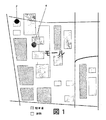
例えば、図1は、ショッピングモールの俯瞰図を示す。図1では、複合商業施設全体の住所で示される位置が、要素2として示されている。ショッピングモールの住所は、一般に、2つの交差する通りの交差部に近い建物の角を指し示す。また、図1に示すように、モール敷地についてのPOIの位置は、ブルズアイ4で示す。ユーザは、ショッピングモールのアドレスを使用して、POI(例えば、特定の店、ガソリンスタンド、モール敷地内の他の施設)へのナビゲートを試みる場合、図1で実証されるように、ナビゲーションシステムは、ユーザを、POIからいくらか離れた場所にナビゲートする。
For example, FIG. 1 shows an overhead view of a shopping mall. In FIG. 1, the position indicated by the address of the entire complex commercial facility is shown as
正確な位置を特定することが特に困難である可能性のある、POIの特定の種類の1つは、電気自動車(EV)充電スタンドである。EV充電スタンドは、ますます一般的になっており、新規のまたは改良された充電スタンドがすぐに稼働し、古いスタンドは、撤去され又は使用不可能となる。充電スタンドは、ショッピングモール、空港、またはコンベンションセンターの大型駐車場などの広い敷地の中に設置され、その充電スタンドの位置を正確に特定することが難しい。 One particular type of POI that can be particularly difficult to pinpoint is the electric vehicle (EV) charging station. EV charging stands are becoming more and more common, new or improved charging stands are up and running, old stands are removed or become unusable. The charging station is installed in a large site such as a large parking lot in a shopping mall, an airport, or a convention center, and it is difficult to accurately identify the position of the charging station.
一態様において、本発明は、車両をターゲット目的地にナビゲートするよう構成された車両ナビゲーティングシステム内のデータを修正する方法である。本方法は、複数の目的地ならびに複数の道路についての位置情報を格納する地理情報データベースを提供することと、車両の充電状態を検出することとを含む。車両の充電状態が、車両が充電中であることを示す場合、本方法は、車両の位置を記録することを含む。本方法は、車両の充電状態が、車両が充電中であることを示す場合の車両の位置を使用して、地理情報データベース内の充電スタンドの位置を更新することを含む。 In one aspect, the present invention is a method for modifying data in a vehicle navigating system configured to navigate a vehicle to a target destination. The method includes providing a geographic information database that stores location information for a plurality of destinations as well as a plurality of roads, and detecting a state of charge of the vehicle. If the state of charge of the vehicle indicates that the vehicle is being charged, the method includes recording the position of the vehicle. The method includes updating the position of the charging station in the geographic information database using the position of the vehicle when the state of charge of the vehicle indicates that the vehicle is charging.
他の態様において、本発明は、ナビゲーションシステムである。本ナビゲーションシステムは、複数の目的地ならびに複数の道路についての位置情報を格納するよう構成された地理情報データベースと、車両の充電状態を検出するよう構成された車両センサとを備える。本ナビゲーションシステムは、地理情報データベースおよび車両センサと通信するプロセッサを備える。本プロセッサは、車両の充電状態が、車両が充電中であることを示す場合、車両の位置を記録すると共に、車両の充電状態が、車両が充電中であることを示している場合の車両の位置を使用して、地理情報データベース内の充電スタンドの位置を更新するよう構成される。 In another aspect, the present invention is a navigation system. The navigation system includes a geographic information database configured to store position information for a plurality of destinations and a plurality of roads, and a vehicle sensor configured to detect a state of charge of the vehicle. The navigation system includes a processor that communicates with a geographic information database and vehicle sensors. The processor records the position of the vehicle if the state of charge of the vehicle indicates that the vehicle is being charged, and the vehicle's state of charge when the state of charge of the vehicle indicates that the vehicle is being charged. The location is used to update the location of the charging station in the geographic information database.
さらに他の態様において、本発明は、プロセッサで使用可能な、コンピュータ可読プログラムコードを有する非一時的コンピュータプログラム製品である。本製品は、複数の目的地ならびに複数の道路についての位置情報を格納する地理情報データベースを提供するコンピュータ可読プログラムコード、車両の充電状態を検出するコンピュータ可読プログラムコード、および車両の充電状態が充電中であることを示す場合に、車両の位置を記録するコンピュータ可読プログラムコードを備える。本製品は、車両の充電状態が充電中であることを示す場合の車両の位置を使用して、地理情報データベース内の充電スタンドの位置を更新するコンピュータ可読プログラムコードを備える。 In yet another aspect, the present invention is a non-transitory computer program product having computer readable program code usable by a processor. This product includes computer readable program code that provides a geographic information database that stores location information for a plurality of destinations and roads, a computer readable program code for detecting a charging state of a vehicle, and a charging state of the vehicle being charged. The computer readable program code for recording the position of the vehicle. The product comprises computer readable program code for updating the position of the charging station in the geographic information database using the position of the vehicle when the state of charge of the vehicle indicates charging.
車両ナビゲーションのためのシステムは、特定の目的地(POI)にナビゲートする際に、車両の動きをモニタする。車両の位置プローブデータと、多数の車載センサを分析することによって、本システムは、POIと関連した位置ならびにルート情報を修正することができる。例えば、POIが、最初に第1の位置と関連づけられたが、実際には、車両を第2の位置にナビゲートする(第1の位置が不正確であることを示す)場合、本システムは、POIと関連した格納された位置情報を修正することができる。特定の実施例の一つでは、本システムを使用して、電気自動車(EV)を、EV充電スタンドに向かわせる補助を行う。この場合、本システムは、車両データを使用して特定のEV充電スタンドと関連した位置を修正するだけでなく、追加センサを使用してEV充電スタンドについての具体的な情報を収集することができる。この追加情報は、本ナビゲーションシステムのデータベースに組み込まれ、ナビゲーション能力の向上をもたらすことができる。 A system for vehicle navigation monitors vehicle movement when navigating to a specific destination (POI). By analyzing vehicle position probe data and a number of in-vehicle sensors, the system can modify the position and route information associated with the POI. For example, if the POI was initially associated with a first position, but in practice, the system navigates the vehicle to a second position (indicating that the first position is incorrect) , The stored location information associated with the POI can be modified. In one particular embodiment, the system is used to assist an electric vehicle (EV) towards an EV charging station. In this case, the system can not only use vehicle data to correct the position associated with a particular EV charging station, but can also use additional sensors to collect specific information about the EV charging station. . This additional information can be incorporated into the database of the navigation system, resulting in improved navigation capabilities.
一実施例において、例えば、本ナビゲーションシステムは、車両位置プローブデータを使用して、EV充電スタンドなどの、特定のPOIへの最も正確なルート、およびその位置を特定する。構造体の下に位置するPOI(例えば、複数階層の立体駐車場の最下層)、またはGPSの受信状態が悪いエリアにあるPOIに対しては、ジャイロスコープや加速度計などの追加車両センサを使用して、車両GPSデータを補う。 In one embodiment, for example, the navigation system uses vehicle position probe data to determine the most accurate route to a particular POI, such as an EV charging station, and its location. Additional vehicle sensors such as gyroscopes and accelerometers are used for POIs located under the structure (for example, the bottom layer of multi-level parking spaces) or POIs in areas where GPS reception is poor Thus, the vehicle GPS data is supplemented.
本ナビゲーションシステムが、EVをEV充電スタンドにナビゲートして、ユーザを補助する場合、EV内のセンサを使用して、EVが充電中であることを特定することで、特定のEVが、稼働中の利用可能な充電スタンドに位置しているか否かを特定する。次いで、車両から取得したプローブデータを使用して、ナビゲーションシステムが、充電スタンドについての正確な位置データを格納しているかを検証することができる。ナビゲーションシステムに格納された充電スタンドの位置から離れた場所に車両が位置しているとプローブデータが示した場合、プローブデータを使用して、その充電スタンドについての位置データを修正することができる。場合によっては、車両のナビゲーションシステムは、多数の車両から受信した位置データを集約する中央コンピュータシステムと通信する。その集約された情報に基づいて、特定のPOIと関連した位置情報は、多数のソースから収集した信頼できる位置データを使用して修正され得る。 When the navigation system navigates an EV to an EV charging stand to assist the user, the specific EV is activated by using the sensor in the EV to identify that the EV is being charged. Determine if you are located in an available charging station inside. The probe data obtained from the vehicle can then be used to verify that the navigation system stores accurate location data for the charging station. If the probe data indicates that the vehicle is located away from the position of the charging station stored in the navigation system, the probe data can be used to correct the position data for that charging station. In some cases, the vehicle navigation system communicates with a central computer system that aggregates location data received from multiple vehicles. Based on that aggregated information, location information associated with a particular POI can be modified using reliable location data collected from multiple sources.
実施例によっては、衛星画像またはオーバーヘッド画像の手検測を行い、本システムに格納された特定のPOIについての位置をさらに修正する。衛星画像またはオーバーヘッド画像は、ナビゲーションシステムで使用する地図を作成するために使用されてもよい。衛星画像またはオーバーヘッド画像を使用することによって特定の目的地や地理的特徴の特定または地図を作成する場合、衛星画像またはオーバーヘッド画像は、一般に、トンネル、駐車場や建物の下層などの地下構造、または、衛星もしくはオーバーヘッド画像ビュー内で不明瞭な特徴などの不明瞭な構造を、マッピング又は位置づけをするために使用することができない。さらに、非公共用道路を使用して、特定の充電スタンドにナビゲートする場合、本システムは、それらの非公共用道路についてのデータを取得することができる。その場合、それらの道路は、ナビゲーションシステムが新規のルートを算出する際に使用することができる。 In some embodiments, satellite images or overhead images are manually inspected to further modify the location for a particular POI stored in the system. The satellite image or overhead image may be used to create a map for use in the navigation system. When using satellite images or overhead images to identify or map specific destinations or geographic features, satellite images or overhead images are typically subsurface structures such as tunnels, parking lots, or under the buildings, or , Obscure structures such as obscure features in satellite or overhead image views cannot be used for mapping or positioning. Furthermore, when navigating to specific charging stations using non-public roads, the system can obtain data about those non-public roads. In that case, those roads can be used when the navigation system calculates a new route.
図2は、例示的ナビゲーションシステム100の機能部品を示すブロック図である。システム100は、データベース102および通信システム108に接続されたナビゲーションプロセッサ104を備える。ナビゲーションプロセッサ104はまた、GPSセンサ110、位置センサ112、EVセンサ114(車両センサ114)、およびユーザインターフェース106に接続される。
FIG. 2 is a block diagram illustrating functional components of an
システム100により、ユーザは、アクセス可能なデータベースに格納されたPOIのリストを検索することで、特定のターゲットPOIを特定することができる。ユーザが特定のターゲットPOIを選択すると、システム100は、ターゲットPOIへのルートを算出し、適切なユーザインターフェースを使用して、そのルートを表示する。システム100がユーザの車両に搭載される実施例では、システム100は、ユーザが車両をターゲットPOIにナビゲートする場合に、車両についての現在の位置プローブデータをモニタする。ユーザがシステム100によって算出されたルートから逸脱する場合、システム100は、それに応じて、ルートを更新することができる。ユーザは、ユーザインターフェースを操作することによって、POIを特定することができ、それ以後に使用する場合に、簡単に検索することができる。
The
システム100はまた、車両を特定のターゲットPOIにナビゲートするまでの間に取得した車両位置プローブデータを使用して、システムの地理情報データベースを更新することができる。例えば、特定のターゲットPOIに向かう車両の実際の経路が、システム100が算出した元の経路よりも効率がよい場合、システム100は、データベースを更新して、より効率のよいルートを示すデータを格納することができる。この新しいデータは、システム100が、今後のルート算出に使用することができる新しい道路(例えば、私道、または新設道路)の存在を示す可能性がある。
The
場合によっては、システム100は、追加データを使用することでナビゲーションシステムの地理情報データベースを補助するために、ユーザの車両内に設置した1つまたは複数のセンサをモニタして、特定のターゲットPOIについてのさまざまな属性を特定する。例えば、特定の位置で、ユーザの車両が、燃料補給作業を受ける場合、または、電気自動車においては充電作業を受ける場合、システム100は、その時点の車両の位置を、利用可能な燃料補給もしくは充電スタンドと関連づけることができる。したがって、本ナビゲーションシステムは、車両位置プローブデータを使用して、ナビゲーションシステムが格納した情報を修正および改善することができる。
In some cases, the
ナビゲーションプロセッサ104は、ナビゲーションシステム100の機能を実現するよう構成される。プロセッサ104は、システム100のさまざまな構成要素と通信して、地理情報を検索し、ユーザ入力を入力し、適切な出力を生成するよう構成される。例えば、プロセッサ104は、データベース102から地理情報を検索し、ユーザ入力に基づいて、選択されたPOIへのルートを算出することができる。算出されると、そのルートは、ユーザインターフェース106を通じて、ユーザが見ることができるように表示される。その場合、ユーザは、ユーザインターフェース106をモニタして、選択したPOIへナビゲートすることができる。
The
データベース102は、多数のPOI、道路、および地理的領域もしくはエリアについての情報を格納する。各道路に対して、データベース102は、カバーする地理的領域を通る各道路の位置またはルートを特定するデータを格納する。さらに、データベース102は、制限速度、通行方向規制、(予想または実際の)渋滞レベル、および名前など、その道路の属性についての情報を格納することができる。
データベース102はまた、POIについて、その位置や住所を表す情報を格納するよう構成される。ホテル、レストラン、博物館、および屋外競技場などの非公共POIに対して、データベース102は、そのPOIで利用可能なサービスや商品、そのPOIについての好ましい駐車場の位置、および営業時間などを示す追加情報を格納することができる。
The
データベース102はまた、都市もしくは町の位置、およびそれぞれの境界情報などの政府による情報を格納することができる。データベース102はまた、カバーする地理的領域内の地形についての情報を格納することができる。地形データは、標高データ、その領域を通る河川の経路、および森や湖の位置を含むことができる。
データベース102は、多数のソースから収集した地理情報を格納することができる。例えば、地理情報は、システム100を製造するときに、データベース102にプレインストールすることができる。その場合、地理情報は、コンパクトディスク(CD)またはデジタル多用途ディスク(DVD)などの媒体を介してユーザに配布される一連の改善もしくは更新により更新することができる。あるいは、地理情報は、携帯電話ネットワークまたは無線配信などの無線通信ネットワークを介して、システム100に配信することができる。
さらに、データベース102のコンテンツは、観測された車の移動またはナビゲーションを含む車両プローブデータに基づいて、システム100によって、補足、改変、または更新され得る。車両プローブデータは、以下に記載するように、GPSセンサ110および位置センサ112を介して収集することができる。例えば、POIへのナビゲートの時に、算出された経路から車両が逸脱したと車両プローブデータが示す場合、逸脱したことを用いて、データベース102を更新することができる。逸脱は、データベース102に以前は格納さえていなかった新しい道路の存在を示す可能性がある。あるいは、逸脱は、特定の目的地にナビゲートすることに使用することができる、(例えば、商業複合施設またはショッピングモールを通る)私道の存在を示す可能性がある。その場合、データベース102は、今後のルート算出時に使用することができる新しい道路情報によって補われ得る。
Further, the content of
さらに、システム100は、車両プローブデータを使用して、既存のPOIの位置を変更し、データベース102内に新しいPOIを作成し、またはデータベース102内にPOIについての新しい情報を作成することができる。例えば、データベース102は、特定の商業施設と関連したPOIを含む可能性がある。ユーザが、その施設を選択し、その施設に向けてナビゲートした後、車両は、データベース102内の施設の位置から、いくぶん離れて動きを止める(すなわち、駐車する)とする。この場合、車両は、施設から、いくぶん距離を取って止まるので、データベース102内の施設の位置は、不正確であることを示す可能性がある。したがって、システム100は、車両が駐車した位置を使用して、データベース102内の施設の実際の位置を更新することができる。このことは、例えば、その施設が広大な私有地に位置する場合や、その敷地の住所が、施設の実際の位置から、いくぶん離れた位置を示す場合に、有益となる可能性がある。この場合、データベース102を更新することによって、POIのより正確な位置を、データベース102内で定義することができる。
Further, the
システム100の実施例によっては、車両が動いているときにいつでも車両プローブデータを収集することができ、システム100は、データベース102に以前は格納されていなかった多数の道路やPOIについての情報を取得することができる。さらに、以下に記載するように、プローブデータは、データベース102に格納された地理情報を補うまたは拡張するために使用され得る。
In some embodiments of the
一実施例において、データベース102は、システム100にローカルに格納され、プロセッサ104は、データベース102と直接通信するように設置される。他の実施例では、データベース102は、プロセッサ104から離れて配置されてもよい。例えば、データベース102は、多数のシステム100と通信するよう構成された中央コンピュータシステムに設けられてもよい。データベース102が中央コンピュータシステムに配置される場合、プロセッサ104は、通信システム108を用いてデータベース102と通信する。通信システム108は、セルラーネットワーク、802.11ネットワーク、または他の無線通信インフラなどの無線通信システムを含むことができる。
In one embodiment, the
GPSセンサ110は、ユーザの車両についての位置情報をプロセッサ104にもたらす。プロセッサ104は、GPSセンサ110を使用して、車両の速度、移動方向、加速度、標高、および他の位置データを判断することができる。場合によっては、プロセッサ104はまた、車両の速度、移動方向、加速度、標高、および他の位置データを提供可能に構成された、1つまたは複数の位置センサ112とも更に通信する。位置センサ112は、ジャイロスコープ、加速度計、車輪パルスセンサ、および車輪角度センサなどを備え、車両の現在位置データを決定する際に補助するデータをもたらしてもよい。プロセッサ104は、GPSセンサ110および位置センサ112の両方から受信したデータを分析して、車両の現在位置データを決定するよう構成される。GPSセンサ110と位置センサ112データとの両方を組み合わせることは、GPSセンサ110または位置センサ112の一方が利用不可能又は機能不能である場合に起こうる問題を軽減するのに有用であるだろう。例えば、GPS信号が高層ビルにより遮断された場合、または車が地下にある場合、GPS衛星が利用できなくなる可能性がある。その場合、プロセッサ104は、GPSセンサ112に依存することなく、1つまたは複数の位置センサ112を用いて、車両の現在位置データを決定することができる。
The GPS sensor 110 provides position information about the user's vehicle to the
ユーザとの意思疎通を可能にするために、プロセッサ104は、ユーザインターフェース106と通信する。ユーザインターフェース106は、プロセッサ104が、ルート、POIデータ、またはユーザに対する他の情報などを表示することを可能にするディスプレイを含む。ユーザインターフェース106はまた、ユーザが、システム100にデータを入力することを可能にする。例えば、ユーザインターフェース106は、タッチスクリーン、キーボード、音声対話システム、またはユーザがシステム100と意思疎通することを可能にする他の制御インターフェースを含んでもよい。ユーザは、ターゲットPOIの選択、特定のPOIに関する追加情報の要求、車両で通ることになる特定のルートを表示することができる地図表示の操作、気に入ったPOIもしくはルートの格納及びユーザの基準設定の変更をすることができる。一実施例においては、ユーザインターフェースは、携帯電話、タブレット、デスクトップPC、ラップトップ、または、例えば、無線通信ネットワークを介してプロセッサ104と通信する他のコンピューティングデバイスなどの、遠隔デバイスを介してもたらされる。
The
さらに図2を参照すると、車両センサ114は、車両の動作状態を検出するよう構成される。検出された状態に基づいて、プロセッサ104は、車両の現在位置についての1つまたは複数の属性を特徴づけることができる。例えば、車両センサ114は、車両が給油していることを検出するよう構成された、給油センサを備えてもよい。電気自動車の場合、車両センサ114は、車両が充電していることを検出するよう構成されてもよい。その場合、車両が給油しているまたは充電していると車両センサ114が示した場合、プロセッサ104は、車両の現在位置を、ガソリンスタンドやEV充電スタンドなどのPOIと関連づけることができる。その場合、位置データを使用して、充電スタンドもしくは給油スタンドの正確な位置を判断することができ、または充電スタンドもしくは給油スタンドの不正確な位置情報を修正することができる。
Still referring to FIG. 2, the
図3は、選択したPOIへのルートを算出するための、システム100のための例示的方法200を示すフローチャートであり、システム100は、取得した車両プローブデータを使用して、ルート算出を補うことができる。
FIG. 3 is a flowchart illustrating an
ステップ202では、システム100は、ユーザインターフェース106を介して、特定のターゲット目的地に対するルーティング要求を入力する。その要求により、データベース102内の特定のPOI、またはデータベース102がカバーする地理的領域内の住所を特定することができる。ターゲットPOIまたは住所を使用して、システム100は、ターゲット目的地の位置を特定する。
In
ステップ204では、システム100は、例えば、GPSセンサ112および/または位置センサ112を介して取得した現在プローブデータを使用して、車両の現在位置を特定する。位置データには、車両の現在の緯度および経度、ならびに現在の標高を含んでもよい。
In
ターゲット目的地および車両の位置を特定すると、ステップ206では、システム100は、車両とターゲットPOIとの間の地理的領域についての情報を検索する。本情報は、車両とターゲットPOIとの間のアクセス可能な道路についてのデータを含むことができ、さらに、その道路についての、種類(例えば、無料高速道路、高速道路、または平面街路)、各道路での速度制限、その道路の状況についてのリアルタイム情報(例えば、交通状況、天候状況など)、燃費のよいルートを算出するのに有益な情報(例えば、坂道)、または近接する給油スタンドもしくは充電スタンドなどの情報を含むことができる。システム100の一実施例において、ステップ204で検索された情報は、データベース102内に格納されている非プローブデータに限定される。したがって、本情報は、製造者がシステム100にプレインストールしたデータを含む可能性があり、またはシステム100に対してストレージ媒体もしくは無線通信ネットワークを介して配信された情報を含む可能性がある。
Once the target destination and vehicle location are identified, at
ステップ208では、システム100は、ステップ206で検索した情報を使用して、ステップ202で特定したターゲット目的地への候補ルートを算出する。ステップ208で候補ルートを算出すると、ステップ210で、システム100は、履歴車両プローブデータが、データベース102内で、ステップ206で算出したルートを補うために利用可能であるかどうかを判断する。上記のように、車両プローブデータを使用して、ターゲット目的地へのより効率的なルートを判断するために用いることができる私道または隠れた道路を特定することができる。そのようなデータが利用できない場合、ステップ212で、システム100は、ユーザインターフェース106を使用して、候補ルートを表示する。
In
しかしながら、車両とターゲット目的地との間の利用できそうな道路についての履歴プローブデータが使用可能である場合、そのプローブデータをステップ214で使用して、ステップ208で事前に算出したルートを更新する。例えば、ターゲット目的地へのより効率のよいルートとなり得る車両とターゲット目的地との間の道路が存在することを、履歴プローブデータが示す場合、算出されたルートは、その道路を使用するよう変更され得る。多くの場合、それらの道路は、商業施設を通る私道や、非プローブデータでは特定されない新設道路が含まれる可能性がある。履歴プローブデータを使用してルートを修正すると、修正されたルートが、ステップ212で、ユーザインターフェース106に表示される。
However, if historical probe data is available for a possible road between the vehicle and the target destination, that probe data is used in
したがって、ナビゲーションシステム100は、取得したプローブデータを使用して、データベース102内に格納された既存の地理的位置データを補うことができる。例えば、図4Aは、ショッピングモールの俯瞰図を示す。図4Aでは、ターゲットPOIは、要素250によって示されるブルズアイの位置にある。さらに、ナビゲーションシステム100は、ショッピングモールの駐車場のいたるところに位置される、多数の履歴車両位置プローブデータポイント252を格納している。プローブデータポイント252は、任意の時点で取得され、図4Aに示すように、ショッピングモールの敷地における車両の位置を表すことができる。したがって、プローブデータポイント252は、一般に、ショッピングモールを通るさまざまな道路の位置を表す。場合によっては、多数の異なる車両から収集された多数のプローブデータポイントは、ナビゲーションシステム100によって互いに組み合わされ、可能な限り多く目的の地理的領域についての情報を提供することによって、最大数のプローブデータポイントが収集されることを確保することができる。図4Bを参照すると、ユーザは、ポイント254からターゲットPOI250へのナビゲートを望む。従来のナビゲーションシステムは、ショッピングモールの敷地を通る利用可能な道路や通路は、そのシステムが何らかしらの情報にもアクセスしたことのないものであるとして、その行程をマップすることはできない。したがって、ユーザは、(ユーザが、ターゲットPOIの位置を知っていると仮定したとしても)ターゲットPOI250にナビゲートするための最も効率的なルートを推測しなければならない。情報が欠落していると、ユーザは、ルート256などの非効率なルートでターゲットPOIに向かう可能性がある。
Thus, the
対照的に、本ナビゲーションシステムは、図3で示したような方法を実現し、利用可能な車両位置プローブデータポイント252を使用して、ショッピングモールの敷地を通る候補ルートを特定することができる。したがって、ナビゲーションシステム100は、プローブデータポイント252を使用して、ユーザが、最適なルート(例えば、ルート258)でターゲットPOI250に運転することを可能にする、ルートを算出することができる。したがって、本ナビゲーションシステム100は、利用可能な道路について取得した車両プローブデータを使用して、効率的なルートの算出を行うことができる。さらに、プローブデータは、1つまたは複数のGPSセンサ110および位置センサ112を使用して取得することができるので、プローブデータは、GPS信号が利用不可能な場合でさえも取得することができる。したがって、地下道路や立体駐車場を通るルートを、ナビゲーションで後に使用するために取得することができる。
In contrast, the navigation system implements the method as shown in FIG. 3 and can use the available vehicle location
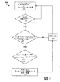
車両位置プローブデータを使用して、ナビゲーションルートを算出することに加えて、上記のように、システム100は、車両プローブデータを使用して、データベース102内のPOIについての位置データを更新することができる。例えば、システム100は、車両プローブデータを使用して、EVの場合には、利用可能な充電スタンドの位置を特定し、またはデータベース102内ですでに特定された充電スタンドの実際の位置を更新ならびに/もしくは修正することができる。例えば、図5は、システム100が、車両プローブデータを使用して、EVの充電スタンドの位置を特定する方法300を示すフローチャートである。方法300は、ユーザが、ユーザインターフェース106を使用して、システム100に、特定のターゲット充電スタンドを特定させることから開始してもよい。ユーザが、ターゲット充電スタンドにナビゲートした後に、例えば、データベース102内のターゲット充電スタンドと関連したデータが不正確である場合、方法300は、データベース102内のターゲット充電スタンドの実際の位置を修正するために使用され得る。
In addition to using the vehicle position probe data to calculate the navigation route, as described above, the
ステップ302では、ユーザが、特定のターゲット充電スタンドにナビゲートすると、システム100は、車両のイグニッションがOFFであることを検出する。さらに、車両センサ114を使用して、システム100は、車両が、現在、充電中であると判断する(車両が、ターゲット充電スタンドの近くにあることを示す)。この時点で、システム100はまた、利用可能な車両プローブデータを使用して、車両が動いていないことを検証してもよい。例えば、車両が充電中に動いているとプローブデータが示す場合、エラー状態にある可能性があり、ユーザに、ユーザインターフェース106を使用して、エラー状態にあることを通知してもよい。
In step 302, when the user navigates to a specific target charging station, the
車両が充電中であると判断すると、システム100は、GPSセンサ110および/または位置センサ112から収集した利用可能なプローブデータを使用して、車両の現在位置を取得する。次いで、その位置情報を、現在、車両が充電を行っているターゲット充電スタンドと関連づけることができる。
When determining that the vehicle is charging, the
ステップ304では、車両の(したがって、充電スタンドの)位置情報を取得すると、システム100は、充電スタンドが公共の充電スタンドであるか私設の充電スタンドであるかを判断する。私設充電スタンドは、私邸内にある可能性があり、または、民間企業と関連していて、適切な許可を受けた人だけが使用するものである可能性がある。逆に、公共充電スタンドは、一般人も利用可能であり、料金を払えば誰でも車両に充電を行うことができる。データベース102から選択したターゲット充電スタンドにユーザがナビゲートした場合、システム100は、データベース102内に格納されたデータを使用して、充電スタンドが公共のものであるか私設のものであるかを判断することができる。
In
他の場合、システム100は、多数のテストを実行して、ターゲット充電スタンドが公共のものであるか私設のものであるかを特定することができる。まず、ターゲット充電スタンドの位置の周りにあるPOIを分析することができる。例えば、特定した充電スタンドが、住宅地域の真ん中に位置する場合、充電は、個人宅で行われている可能性があり、一般人は利用できない。同様に、特定した充電スタンドが、私有地にある(例えば、民間施設の周辺に位置する)場合、その充電スタンドは、私設のものである可能性がある。逆に、特定した充電スタンドが、大型商業複合施設またはショッピングモールの中、空港内、または公共の駐車場内などの、公共のアクセス可能エリアに設置されている場合、その特定した充電スタンドは、一般的に利用可能である可能性がある。
In other cases, the
実施例によっては、車両センサ114は、充電スタンドが一般的に利用可能であるかどうかを示すデータを取得するよう構成してもよい。例えば、私設充電システムは、公共の充電スタンドと私設の充電スタンドとを区別するために使用することができる特定の信号を、車両センサ114に送信してもよい。
In some embodiments, the
充電スタンドが私設のものであると判断された場合、その充電スタンドについてのデータは取得されず、方法300を再開する。
If it is determined that the charging station is private, no data about the charging station is acquired and the
しかしながら、充電スタンドが公共のものである場合、ステップ306では、システム100は、ステップ302で取得した車両プローブデータが、データベース102に格納されている充電スタンドのデータと異なるかどうかを判断する。ステップ302で取得されたプローブデータが、データベース102内の位置の閾値距離(例えば、10メートル)内である位置を特定した場合、データベース102内にすでに格納された位置情報をステップ308で検証したと考え、方法300をリセットする。
However, if the charging station is public, at
しかしながら、ステップ302で取得されたプローブデータが、データベース102内で特定した位置から、閾値距離よりも遠く離れた位置であると判定した場合、取得された位置情報は、ステップ310で、例えば、通信システム108を使用して、中央コンピュータシステムに送信される。
However, if it is determined that the probe data acquired in step 302 is a position that is farther than the threshold distance from the position specified in the
中央コンピュータシステムは、新しい位置情報を受信すると、充電スタンドの位置を特定するプローブ位置情報が、多数の異なる車両から取得されたものであるかどうかを判断する。例えば、3台の車両が、それぞれの位置から一定の距離以内(例えば、それぞれ1メートル以内)にある充電スタンドの位置を特定するプローブ位置データをそれぞれ供給する。プローブ位置データで特定される位置が、データベース102内で特定された位置から閾値距離以上離れている場合、中央コンピュータシステムは、データベース102内で特定した位置が不正確であると判断する可能性がある。不正確である場合(および、十分な台数の車両が正確な位置を報告した場合)、中央コンピュータシステムは、それに応じて、地図情報を更新するよう車両に指示することができる。したがって、ステップ312では、十分な台数の車両が正確な位置情報を報告した場合、システム100は、データベース102内の充電スタンドの位置を、新規の修正された位置に更新するよう指示を受け取る。一実施例において、修正された位置は、以前に他の車両から受信した、報告された位置のそれぞれの中間ポイントである。他の実施例では、システム100は、単に、位置情報を、ステップ302で取得したプローブ位置データで更新する。
When the central computer system receives the new location information, the central computer system determines whether the probe location information that identifies the location of the charging station has been obtained from a number of different vehicles. For example, three vehicles each supply probe position data specifying the position of a charging station within a certain distance (for example, within 1 meter each) from each position. If the position specified in the probe position data is more than a threshold distance from the position specified in the
システム100の他の実施例では、POI、特に充電スタンド、ならびに候補道路についての位置情報は、組み合わせまたはオーバーヘッド画像とデータベース102を直接変更するためのソフトウェアツールを使用して、個人が直接更新することができる。例えば、特定の充電スタンドが外部エリアに位置する場合、衛星画像またはオーバーヘッド画像を使用して、その充電スタンドについての正確な位置を判断してもよい。その場合、その位置は、データベース102に入力され、システム100が、その充電スタンドへのナビゲーションルートを提供することを可能にすることができる。同様に、新設道路または私道の場合、衛星画像またはオーバーヘッド画像を使用して、データベース102内に格納するそれらの道路の位置および経路を特定することができる。この場合も、データベース102内に格納した後、これらの新設道路は、システム100が、特定のターゲット目的地への算出されるルートにおいて使用することができる。
In another embodiment of the
本発明は、好適な実施形態について説明してきたが、当業者は、形態および詳細について変更が可能であり、本発明の主旨および範囲から逸脱することなく、本発明の要素を同等物で置き換えることが可能であることを認識するであろう。したがって、本発明は、本発明を実施するために開示された特定の実施形態に限定されるものではないが、添付の特許請求の範囲の範囲に入る全ての実施形態を包含することが意図される。 Although the present invention has been described with reference to preferred embodiments, workers skilled in the art can make changes in form and detail and substitute equivalents for the elements of the invention without departing from the spirit and scope of the invention. Will recognize that is possible. Accordingly, the present invention is not intended to be limited to the particular embodiments disclosed for carrying out the invention, but is intended to encompass all embodiments that fall within the scope of the appended claims. The
Claims (13)
複数の目的地ならびに複数の道路についての位置情報を格納する地理情報データベースを提供するステップと、
車両の充電状態を検出するステップと、
前記車両の前記充電状態が、前記車両が充電スタンドに接続されかつ前記充電スタンドで充電中と示されるとき、前記車両の位置を記録するステップと、
前記車両の前記位置を使って前記地理情報データベース中から前記車両に近接する少なくとも1個の目的地を特定するステップと、
前記少なくとも1個の目的地を分析して前記充電スタンドが公的にアクセス可能かどうかを決定するステップと、
前記充電スタンドが公的にアクセス可能であるときだけ、前記車両の前記充電状態が充電中であることを示す場合の前記車両の前記位置を使用して、前記地理情報データベース内の前記充電スタンドの位置情報を更新し、前記車両の履歴プローブデータおよび前記車両の前記位置を使用して、前記地理情報データベース内の前記複数の道路のうちの1つの前記位置情報を更新するステップと、を備え、前記複数の道路のうちの前記1つが前記充電スタンドへのルートを提供する、データ修正方法。 A data correction method for correcting data in a vehicle navigation system configured to navigate a vehicle to a target destination,
Providing a geographic information database storing location information for multiple destinations as well as multiple roads;
Detecting the state of charge of the vehicle;
Recording the position of the vehicle when the state of charge of the vehicle is indicated that the vehicle is connected to a charging station and is being charged at the charging station;
Identifying at least one destination proximate to the vehicle from the geographic information database using the location of the vehicle;
Analyzing the at least one destination to determine whether the charging station is publicly accessible;
The location of the charging station in the geographic information database is used only when the charging station is publicly accessible using the location of the vehicle when the charging status of the vehicle indicates charging. Updating the position information and using the historical probe data of the vehicle and the position of the vehicle to update the position information of one of the roads in the geographic information database, A data correction method, wherein the one of the plurality of roads provides a route to the charging station.
前記車両の現在位置を特定するステップと、
前記地理情報データベースを使用して、前記車両の前記現在位置から前記ターゲット目的地までのルートを算出するステップと、
前記ユーザインターフェースを使用して、前記ルートを表示するステップと
を備える、請求項1に記載のデータ修正方法。 Receiving the selected target destination specific information from the plurality of target destinations in the geographic information database using a user interface when the target destination is the charging station;
Identifying the current position of the vehicle;
Calculating a route from the current location of the vehicle to the target destination using the geographic information database;
The data correction method according to claim 1, further comprising: displaying the route using the user interface.
前記距離が所定の閾値を超えるとき、前記地理情報データベース内の前記充電スタンドの前記位置情報を更新するステップを備える、請求項1に記載のデータ修正方法。 Determining a distance between the position of the vehicle and the position of the charging station stored in the geographic information database;
The data correction method according to claim 1, further comprising: updating the position information of the charging station in the geographic information database when the distance exceeds a predetermined threshold.
複数の目的地ならびに複数の道路についての位置情報を格納するよう構成された地理情報データベースと、
車両の充電状態を検出するよう構成された車両センサと、
前記地理情報データベースおよび前記車両センサと通信するプロセッサと
を備え、
前記プロセッサは、
前記車両の前記充電状態が充電中であることを示す場合、前記車両の位置を記録すると共に、前記車両の前記位置と前記地理情報データベース内の充電スタンドの位置との間の距離を決定し、
前記車両の前記位置と前記充電スタンドの前記位置との間の前記距離が所定の閾値を超えるとともに前記充電スタンドが公的にアクセス可能である場合のみ、前記車両の前記充電状態が充電中であることを示すときに、前記車両の前記位置を使用して前記地理情報データベース内の前記充電スタンドの前記位置情報を更新し、
前記車両の履歴プローブデータおよび前記車両の前記位置を使用して、前記地理情報データベース内の前記複数の道路のうちの1つの前記位置情報を更新する、よう構成されており、前記複数の道路のうちの前記1つは前記充電スタンドまでのルートを提供する、ナビゲーションシステム。 A navigation system,
A geographic information database configured to store location information for multiple destinations as well as multiple roads;
A vehicle sensor configured to detect a state of charge of the vehicle;
A processor in communication with the geographic information database and the vehicle sensor;
The processor is
If the state of charge of the vehicle indicates charging, record the location of the vehicle and determine the distance between the location of the vehicle and the location of the charging station in the geographic information database;
The charging state of the vehicle is charging only if the distance between the position of the vehicle and the position of the charging station exceeds a predetermined threshold and the charging station is publicly accessible. When updating the location information of the charging station in the geographic information database using the location of the vehicle,
Updating the location information of one of the plurality of roads in the geographic information database using the historical probe data of the vehicle and the position of the vehicle; A navigation system wherein the one of them provides a route to the charging station.
前記車両の現在位置を特定し、
前記地理情報データベースを使用して、前記車両の前記現在位置から、前記ターゲット目的地までのルートを算出し、
前記ユーザインターフェースを使用して、前記ルートを表示する、よう構成された、請求項6に記載のナビゲーションシステム。 The processor receives specific information of the selected target destination using a user interface from the plurality of target destinations in the geographic information database;
Identifying the current position of the vehicle;
Using the geographic information database, calculating a route from the current position of the vehicle to the target destination,
The navigation system of claim 6, configured to display the route using the user interface.
複数の目的地ならびに複数の道路についての位置情報を格納する地理情報データベースを提供するコンピュータ可読プログラムコードと、
車両の充電状態を検出するコンピュータ可読プログラムコードと、
前記車両の前記充電状態が充電中であることを示す場合、前記車両の位置を記録するコンピュータ可読プログラムコードと、
前記車両の前記充電状態が充電中であることを示している場合に、前記車両の前記位置を使用して、前記地理情報データベース内の充電スタンドの前記位置情報を更新するコンピュータ可読プログラムコードと、
前記車両の前記履歴プローブデータおよび前記車両の前記位置を使用して前記地理情報データベース内の前記複数の道路のうちの1つの前記位置情報を更新するコンピュータ可読プログラムコードと、を備え、
前記複数の道路のうちの前記1つは、前記充電スタンドまでのルートを提供し、
前記充電スタンドの前記位置情報の更新は、前記充電スタンドが公的にアクセス可能である場合にのみ行われる、
非一時的コンピュータプログラム製品。 A non-transitory computer program product having computer readable program code usable by a processor,
Computer readable program code for providing a geographic information database storing location information for a plurality of destinations as well as a plurality of roads;
Computer readable program code for detecting the state of charge of the vehicle;
If the state of charge of the vehicle indicates that it is being charged, computer readable program code that records the position of the vehicle;
Computer readable program code for updating the location information of the charging station in the geographic information database using the location of the vehicle when the state of charge of the vehicle indicates charging.
Computer readable program code for updating the location information of one of the plurality of roads in the geographic information database using the historical probe data of the vehicle and the location of the vehicle;
The one of the plurality of roads provides a route to the charging station ;
Updating of the position information of the charging station, the charging station is Ru place only if it is publicly accessible,
Non-transitory computer program product.
前記車両の現在位置を特定するコンピュータ可読プログラムコードと、
前記地理情報データベースを使用して、前記車両の前記現在位置から、前記ターゲット目的地へのルートを算出するコンピュータ可読プログラムコードと、
前記ユーザインターフェースを使用して、前記ルートを表示するコンピュータ可読プログラムコードと
を備える、請求項10に記載の非一時的コンピュータプログラム製品。 Computer readable program code for receiving, from a plurality of target destinations in the geographic information database, specific information of the selected target destination using a user interface;
Computer readable program code for identifying a current position of the vehicle;
Computer readable program code for calculating a route from the current location of the vehicle to the target destination using the geographic information database;
The non-transitory computer program product of claim 10 , comprising: computer readable program code for displaying the route using the user interface.
Applications Claiming Priority (3)
| Application Number | Priority Date | Filing Date | Title |
|---|---|---|---|
| US13/301,038 | 2011-11-21 | ||
| US13/301,038 US9121718B2 (en) | 2011-11-21 | 2011-11-21 | Method and system for improved vehicle navigation |
| PCT/US2012/066015 WO2013078177A1 (en) | 2011-11-21 | 2012-11-20 | Method and system for updating a poi database for improved vehicle navigation |
Publications (3)
| Publication Number | Publication Date |
|---|---|
| JP2014533836A JP2014533836A (en) | 2014-12-15 |
| JP2014533836A5 JP2014533836A5 (en) | 2016-01-14 |
| JP5936016B2 true JP5936016B2 (en) | 2016-06-15 |
Family
ID=47428987
Family Applications (1)
| Application Number | Title | Priority Date | Filing Date |
|---|---|---|---|
| JP2014542568A Expired - Fee Related JP5936016B2 (en) | 2011-11-21 | 2012-11-20 | Method and system for updating a POI database to improve vehicle navigation |
Country Status (5)
| Country | Link |
|---|---|
| US (1) | US9121718B2 (en) |
| JP (1) | JP5936016B2 (en) |
| CN (1) | CN104053968B (en) |
| DE (1) | DE112012004835T5 (en) |
| WO (1) | WO2013078177A1 (en) |
Families Citing this family (29)
| Publication number | Priority date | Publication date | Assignee | Title |
|---|---|---|---|---|
| JP2013170877A (en) * | 2012-02-20 | 2013-09-02 | Denso Corp | Center device and navigation system |
| US20130275368A1 (en) * | 2012-04-13 | 2013-10-17 | General Motors Llc | Maintaining Electrical Vehicle Recharging Station Data |
| JP6020150B2 (en) * | 2012-12-27 | 2016-11-02 | 日産自動車株式会社 | Vehicle information providing device |
| US9355560B2 (en) * | 2014-01-31 | 2016-05-31 | Here Global B.V. | Differentiation of probe reports based on quality |
| SE539156C2 (en) * | 2014-02-18 | 2017-04-18 | Scania Cv Ab | Map structure in a vehicle |
| US10228258B2 (en) * | 2014-12-03 | 2019-03-12 | Strava, Inc. | Determining top venues from aggregated user activity location data |
| CN104807471A (en) * | 2015-03-31 | 2015-07-29 | 国网山东省电力公司青岛供电公司 | Navigation method and device |
| DE102015208229A1 (en) * | 2015-05-05 | 2016-11-10 | Zf Friedrichshafen Ag | Method for driver assistance in an at least partially electrically driven motor vehicle |
| DE102015210325A1 (en) * | 2015-06-03 | 2016-12-08 | Bayerische Motoren Werke Aktiengesellschaft | Method and system for monitoring charging stations |
| DE102015215699A1 (en) * | 2015-08-18 | 2017-02-23 | Robert Bosch Gmbh | Method for locating an automated motor vehicle |
| US10857902B2 (en) * | 2016-04-01 | 2020-12-08 | Power Hero Corp. | Automated system for managing and providing a network of charging stations |
| DE102016004889A1 (en) * | 2016-04-22 | 2017-10-26 | Kuka Roboter Gmbh | Supply of electrical energy and / or fuel to a motor vehicle by means of a robot |
| CN107543553B (en) * | 2016-06-27 | 2020-12-15 | 阿里巴巴(中国)有限公司 | Interest point updating method and device |
| US11796340B2 (en) * | 2017-04-03 | 2023-10-24 | Power Hero Corp. | Universal automated system for identifying, registering and verifying the existence, location and characteristics of electric and other power outlets by random users and for retrieval and utilization of such parametric data and outlets by all users |
| US10679312B2 (en) * | 2017-04-25 | 2020-06-09 | Lyft Inc. | Dynamic autonomous vehicle servicing and management |
| WO2018205134A1 (en) * | 2017-05-09 | 2018-11-15 | 深圳实现创新科技有限公司 | Intelligent traffic charging pile searching method and system |
| CN106935074A (en) * | 2017-05-09 | 2017-07-07 | 深圳实现创新科技有限公司 | The charging pile lookup method and system of intelligent transportation |
| JP2019079205A (en) * | 2017-10-23 | 2019-05-23 | トヨタ自動車株式会社 | On-vehicle equipment and portable terminal |
| WO2019173315A1 (en) * | 2018-03-05 | 2019-09-12 | Mobileye Vision Technologies Ltd. | Systems and methods for anonymizing navigation information |
| US11135937B2 (en) * | 2018-04-06 | 2021-10-05 | Cisco Technology, Inc. | Vehicle charging leveraging telecommunication infrastructure |
| JP2020067341A (en) * | 2018-10-23 | 2020-04-30 | 本田技研工業株式会社 | Information processing server for providing information of position of charge station, information processing method, vehicle, method for controlling vehicle, program and information providing system |
| CN109769209A (en) * | 2018-11-23 | 2019-05-17 | 上海电享信息科技有限公司 | Charging pile/charging station position error correction method |
| CN111301186A (en) * | 2018-12-12 | 2020-06-19 | 上海博泰悦臻网络技术服务有限公司 | Automatic charging station acquisition method and system and vehicle-mounted terminal |
| CN109977527B (en) * | 2019-03-21 | 2021-04-16 | 华北电力大学 | Charging pile configuration method for urban public charging station network |
| CN111698298B (en) * | 2020-05-28 | 2023-02-17 | 阿波罗智联(北京)科技有限公司 | Method and device for determining newly added vehicle energy station |
| DE102020122266A1 (en) | 2020-08-26 | 2022-03-03 | Audi Aktiengesellschaft | Method for customizing a digital charging station map, device for a vehicle for customizing a digital charging station map, and motor vehicle |
| DE102021205667A1 (en) | 2021-06-03 | 2022-12-08 | Volkswagen Aktiengesellschaft | Method for building and updating a database for charging devices and motor vehicles |
| DE102022109326A1 (en) | 2022-04-14 | 2023-10-19 | Bayerische Motoren Werke Aktiengesellschaft | Method and device for recognizing a refueling location |
| DE102022110962A1 (en) | 2022-05-04 | 2023-11-09 | Bayerische Motoren Werke Aktiengesellschaft | Method for providing navigation information about a position of a charging station with an in-vehicle information system of a vehicle, computer-readable medium, system, and vehicle |
Family Cites Families (10)
| Publication number | Priority date | Publication date | Assignee | Title |
|---|---|---|---|---|
| JP2006293876A (en) * | 2005-04-14 | 2006-10-26 | Hitachi Ltd | Traffic information collection device and on-vehicle equipment |
| JP4365429B2 (en) * | 2007-07-24 | 2009-11-18 | トヨタ自動車株式会社 | Navigation device for displaying charging information and vehicle equipped with the device |
| WO2009105448A2 (en) * | 2008-02-19 | 2009-08-27 | Bloom Energy Corporation | Fuel cell system for charging an electric vehicle |
| JP5560788B2 (en) | 2009-06-26 | 2014-07-30 | 日産自動車株式会社 | Information provision device |
| CN101995253B (en) * | 2009-08-14 | 2013-03-27 | 晨星软件研发(深圳)有限公司 | Satellite navigation device and related navigation method thereof |
| WO2011023244A1 (en) | 2009-08-25 | 2011-03-03 | Tele Atlas B.V. | Method and system of processing data gathered using a range sensor |
| US8294420B2 (en) * | 2009-09-29 | 2012-10-23 | Schneider Electric USA, Inc. | Kiosk vehicle charging and selecting systems |
| WO2011098195A1 (en) | 2010-02-15 | 2011-08-18 | Tomtom International B.V. | Methods and systems for obtaining charging location information |
| US8577528B2 (en) | 2010-11-16 | 2013-11-05 | Honda Motor Co., Ltd. | System and method for updating charge station information |
| US9505318B2 (en) * | 2011-05-26 | 2016-11-29 | Sierra Smart Systems, Llc | Electric vehicle fleet charging system |
-
2011
- 2011-11-21 US US13/301,038 patent/US9121718B2/en not_active Expired - Fee Related
-
2012
- 2012-11-20 CN CN201280067508.2A patent/CN104053968B/en not_active Expired - Fee Related
- 2012-11-20 WO PCT/US2012/066015 patent/WO2013078177A1/en active Application Filing
- 2012-11-20 JP JP2014542568A patent/JP5936016B2/en not_active Expired - Fee Related
- 2012-11-20 DE DE201211004835 patent/DE112012004835T5/en not_active Withdrawn
Also Published As
| Publication number | Publication date |
|---|---|
| DE112012004835T5 (en) | 2014-09-18 |
| US20130131974A1 (en) | 2013-05-23 |
| US9121718B2 (en) | 2015-09-01 |
| JP2014533836A (en) | 2014-12-15 |
| CN104053968A (en) | 2014-09-17 |
| WO2013078177A1 (en) | 2013-05-30 |
| CN104053968B (en) | 2017-05-24 |
Similar Documents
| Publication | Publication Date | Title |
|---|---|---|
| JP5936016B2 (en) | Method and system for updating a POI database to improve vehicle navigation | |
| US10502577B2 (en) | Iterative map learning based on vehicle on-board sensor data | |
| US8910010B2 (en) | Method of detecting transportation network database errors and devices thereof | |
| US10140854B2 (en) | Vehicle traffic state determination | |
| US9778061B2 (en) | Road density calculation | |
| US9418550B2 (en) | Navigation apparatus, server apparatus and method of collecting parking location information | |
| RU2516575C2 (en) | Device and method for determining parking information | |
| US10495470B2 (en) | Map having computer executable instructions embedded therein | |
| CN105841707B (en) | Navigation system using map mechanism and method of operation thereof | |
| US7925425B2 (en) | Navigation information distribution systems, methods, and programs | |
| US20130131980A1 (en) | Resolving gps ambiguity in electronic maps | |
| WO2018057331A1 (en) | Discovering points of entry to a location | |
| TW200829883A (en) | Navigation device and method for displaying traffic information | |
| US9411822B2 (en) | System and method of generating and using open sky data | |
| EP3757962A1 (en) | Dynamic privacy-sensitive operating modes | |
| US20200242934A1 (en) | Dual mode indoor parking data delivery and map integration | |
| US20090143979A1 (en) | Position registering apparatus, route retrieving apparatus, position registering method, position registering program, and recording medium | |
| US10883839B2 (en) | Method and system for geo-spatial matching of sensor data to stationary objects | |
| CN113447035B (en) | Method, device and computer program product for generating a parking lot geometry | |
| US20220361008A1 (en) | Traversable network-aware radio modeling | |
| JP2006284230A (en) | Navigation device, navigation method, and navigation program |
Legal Events
| Date | Code | Title | Description |
|---|---|---|---|
| A521 | Request for written amendment filed |
Free format text: JAPANESE INTERMEDIATE CODE: A523 Effective date: 20151119 |
|
| A621 | Written request for application examination |
Free format text: JAPANESE INTERMEDIATE CODE: A621 Effective date: 20151119 |
|
| A871 | Explanation of circumstances concerning accelerated examination |
Free format text: JAPANESE INTERMEDIATE CODE: A871 Effective date: 20151119 |
|
| A975 | Report on accelerated examination |
Free format text: JAPANESE INTERMEDIATE CODE: A971005 Effective date: 20151221 |
|
| A131 | Notification of reasons for refusal |
Free format text: JAPANESE INTERMEDIATE CODE: A131 Effective date: 20160105 |
|
| A521 | Request for written amendment filed |
Free format text: JAPANESE INTERMEDIATE CODE: A523 Effective date: 20160304 |
|
| TRDD | Decision of grant or rejection written | ||
| A01 | Written decision to grant a patent or to grant a registration (utility model) |
Free format text: JAPANESE INTERMEDIATE CODE: A01 Effective date: 20160329 |
|
| RD03 | Notification of appointment of power of attorney |
Free format text: JAPANESE INTERMEDIATE CODE: A7423 Effective date: 20160411 |
|
| A61 | First payment of annual fees (during grant procedure) |
Free format text: JAPANESE INTERMEDIATE CODE: A61 Effective date: 20160426 |
|
| R150 | Certificate of patent or registration of utility model |
Ref document number: 5936016 Country of ref document: JP Free format text: JAPANESE INTERMEDIATE CODE: R150 |
|
| R250 | Receipt of annual fees |
Free format text: JAPANESE INTERMEDIATE CODE: R250 |
|
| LAPS | Cancellation because of no payment of annual fees |