JP5587366B2 - Mobile terminal device and map data management method - Google Patents
Mobile terminal device and map data management method Download PDFInfo
- Publication number
- JP5587366B2 JP5587366B2 JP2012149309A JP2012149309A JP5587366B2 JP 5587366 B2 JP5587366 B2 JP 5587366B2 JP 2012149309 A JP2012149309 A JP 2012149309A JP 2012149309 A JP2012149309 A JP 2012149309A JP 5587366 B2 JP5587366 B2 JP 5587366B2
- Authority
- JP
- Japan
- Prior art keywords
- travel
- time
- travel route
- mobile terminal
- map data
- Prior art date
- Legal status (The legal status is an assumption and is not a legal conclusion. Google has not performed a legal analysis and makes no representation as to the accuracy of the status listed.)
- Expired - Fee Related
Links
Images


Landscapes
- Instructional Devices (AREA)
- Navigation (AREA)
- Traffic Control Systems (AREA)
Description
本発明は、カーナビゲーション装置等の移動端末装置における地図データの管理・表示技術に関する。 The present invention relates to a map data management / display technique in a mobile terminal device such as a car navigation device.
従来の技術として、特開2000−311175号公報に開示された技術がある。
当該従来技術では、移動体に搭載された情報処理装置はGPS(Global Positioning System)衛星からの測位情報に基づき移動体の現在位置を測位するとともに移動体の現在位置を地図データに反映させて表示する。そして、移動体が地図データでは道路としていない位置を走行した場合には、移動体の走行軌跡を追加分道路として表示し、また、追加分道路データとして記憶装置に記憶する。
As a conventional technique, there is a technique disclosed in Japanese Patent Application Laid-Open No. 2000-31175.
In the related art, the information processing device mounted on the moving body measures the current position of the moving body based on positioning information from a GPS (Global Positioning System) satellite and reflects the current position of the moving body on the map data and displays it. To do. When the mobile body travels at a position that is not a road in the map data, the travel locus of the mobile body is displayed as an additional road, and is stored in the storage device as additional road data.
上記の従来技術では、GPS衛星からの測位情報のみに基づいて移動体の現在位置を測位しているため精度よく測位を行うことができず、測位結果と実際の移動体の位置との間に数メートル〜数十メートルの測位誤差が生じる。
このため、移動体の走行軌跡に基づいて追加分道路を表示しても実際の道路の位置とは異なる位置に追加分道路が表示され、正確な地図データの表示ができない事態となる。
また、実際の道路の位置を反映しない追加分道路データが記憶装置に記憶されることになるため、後に移動体が当該追加分道路を再度走行する際に当該追加分道路を走行しているにもかかわらず地図データ上では当該追加分道路以外の位置を走行している旨の表示がなされ、正確なナビゲーションができないことになる。
In the above prior art, since the current position of the moving body is measured based only on the positioning information from the GPS satellite, it is impossible to perform the positioning accurately, and the positioning result and the actual position of the moving body are not. A positioning error of several meters to several tens of meters occurs.
For this reason, even if the additional road is displayed based on the traveling locus of the moving body, the additional road is displayed at a position different from the actual road position, and accurate map data cannot be displayed.
In addition, since additional road data that does not reflect the actual road position is stored in the storage device, when the mobile object travels on the additional road again later, Nevertheless, on the map data, it is displayed that the vehicle is traveling on a position other than the additional road, and accurate navigation is not possible.
本発明は、上記のような従来技術の問題点を解決することを目的の一つとしており、移動体の移動軌跡に基づき地図データになかった新たな道路を正確な位置で表示し、また、新たな道路を正確な位置で表示するように地図データの内容を更新することを目的の一つとする。
更に、本発明は、移動体の過去の移動実績に基づき複数の移動ルートの中から移動に最も適した移動ルートを選択し、選択した移動ルートを適切に通知することを目的の一つとする。
The present invention aims to solve the problems of the prior art as described above, and displays a new road that is not in the map data based on the movement trajectory of the moving object at an accurate position. One of the purposes is to update the contents of the map data so that a new road is displayed at an accurate position.
Furthermore, an object of the present invention is to select a travel route that is most suitable for travel from a plurality of travel routes based on past travel results of the mobile body, and to appropriately notify the selected travel route.
本発明に係る移動端末装置は、
移動体に配置され、地図データを保有する移動端末装置であって、
複数の走行可能な移動ルートが存在する特定区間について、移動ルートごとに予想通行時間を記憶する予想通行時間記憶部と、
特定区間を含むエリアの地図データを記憶する地図データ記憶部と、
移動体の所在位置を測位する測位部と、
前記測位部の測位結果に基づき移動体の所在位置を地図データ上にマッピングするマッピング部と、
前記マッピング部によるマッピング結果に基づき移動体が特定区間内及び特定区間から所定距離内のいずれかに所在するか否かを判断し、移動体が特定区間内及び特定区間から所定距離内のいずれかに所在すると判断した場合に前記予想通行時間記憶部に記憶された移動ルートごとの予想通行時間に基づき複数の走行可能な移動ルートの中から特定の移動ルートを選択する移動ルート選択部と、
前記移動ルート選択部により選択された移動ルートを通知する移動ルート通知情報を、他の移動体に配置された他の移動端末装置に対して送信し、他の移動端末装置との間で移動ルート通知情報を共有する通信部とを有することを特徴とする。
The mobile terminal device according to the present invention is
A mobile terminal device arranged on a mobile body and holding map data,
For a specific section where there are a plurality of travel routes that can travel, an expected travel time storage unit that stores an expected travel time for each travel route;
A map data storage unit for storing map data of an area including a specific section;
A positioning unit for positioning the location of the moving object;
A mapping unit that maps the location of the moving object on map data based on the positioning result of the positioning unit;
Based on the mapping result by the mapping unit, it is determined whether the moving body is located within the specific section and within the predetermined distance from the specific section, and the mobile body is either within the specific section or within the predetermined distance from the specific section. A travel route selection unit that selects a specific travel route from a plurality of travel routes that can be traveled based on the predicted travel time for each travel route stored in the predicted travel time storage unit when it is determined that
The travel route notification information for notifying the travel route selected by the travel route selection unit is transmitted to another mobile terminal device arranged in another mobile body, and the travel route between the other mobile terminal devices is transmitted. And a communication unit that shares the notification information.
本発明によれば、測位情報及び測位情報を補正するための補正情報を用いて移動体の所在位置を高精度に測位することができるため、移動ルートごとの通行時間を計測することができ、このため、移動体の過去の移動実績に基づき複数の移動ルートの中から移動に最も適した移動ルートを選択し、選択した移動ルートを適切に通知することができる。 According to the present invention, it is possible to measure the location of the moving body with high accuracy using the positioning information and the correction information for correcting the positioning information, so it is possible to measure the transit time for each moving route, For this reason, it is possible to select a movement route most suitable for movement from a plurality of movement routes based on the past movement record of the moving body, and appropriately notify the selected movement route.
実施の形態1.
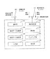
図1は、本実施の形態の通信システムの構成を示す原理図である。
移動体1は、例えば車輌であり、移動端末装置10が配置されている。
移動端末装置10は、例えばカーナビゲーション装置であり、4機以上のGPS衛星2より測位情報を受信するとともに準天頂衛星3より補正情報を受信し、測位情報及び補正情報に基づき移動体1の所在位置を高精度に測位する。
GPS衛星2からの測位情報は、電波が地上に届くまでに電離層の影響及び対流圏遅延の影響を受け、このため測位情報のみを用いて測位を行ったのでは測位結果に誤差が生じることが多い。補正情報は、このような誤差を補正するための情報であり、全国947ヶ所に配置された電子基準点により例えばD(Differential)−GPS技術に基づき生成される。
また、移動端末装置10は地図データを保有しており、移動体1の所在位置を地図データ上に反映させるとともに、移動体1が地図データ上で道路とされない位置を移動した場合には移動軌跡に沿って道路データを追加する更新を行う。そして、移動端末装置10は更新内容を通知する更新内容通知を地図データ管理センター4の地図データ管理装置40に送信する。地図データ管理センター4は、例えば地図製作会社等である。
Embodiment 1 FIG.
FIG. 1 is a principle diagram showing a configuration of a communication system according to the present embodiment.
The mobile body 1 is, for example, a vehicle, and a mobile terminal device 10 is arranged.
The mobile terminal device 10 is, for example, a car navigation device and receives positioning information from four or more GPS satellites 2 and also receives correction information from the quasi-zenith satellite 3 and the location of the mobile body 1 based on the positioning information and the correction information. Measure the position with high accuracy.
The positioning information from the GPS satellite 2 is affected by the ionosphere and the troposphere delay before the radio wave reaches the ground. Therefore, positioning using only the positioning information often causes errors in the positioning results. . The correction information is information for correcting such an error, and is generated based on, for example, D (Differential) -GPS technology by electronic reference points arranged at 947 locations nationwide.
In addition, the mobile terminal device 10 has map data, reflects the location of the moving body 1 on the map data, and moves when the moving body 1 moves on a position that is not a road on the map data. Update to add road data along with. Then, the mobile terminal device 10 transmits an update content notification for notifying the update content to the map data management device 40 of the map data management center 4. The map data management center 4 is, for example, a map production company.
次に、準天頂衛星3について説明する。
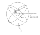
図13は、準天頂衛星の軌跡を説明する図であり、図13において、300は、準天頂衛星である。
準天頂衛星300は、赤道面から約45度の傾斜角及び、例えば離心率0.099程度の周回軌道により、地球の自転に合わせて1日に1周回している。なお、赤道面からの傾斜角は、設計により任意に設定してもよい。また、準天頂衛星300は、昇交点赤経(赤道面との交点)において120度ずつ離れるように3機が配置されている。
図14は、地表面上に投影される準天頂衛星軌道の軌跡を説明する図である。
図14においては、地上を固定して考えた場合に、図13における準天頂衛星300の軌跡を示している。図14に示すように、準天頂衛星300は、赤道上を交点とする「8の字」を描くように周回している。3機の準天頂衛星300は、軌道面を異にするが8時間ずつ交代するように、切れ目なく日本上空に位置している。また、地域を日本で考えた場合、仰角が70度以上の準天頂衛星300が常に存在することになる。切れ目なく日本上空に位置しているため、仰角が70度以上の準天頂衛星300が常に存在し、受信者が地上で準天頂衛星300から電波を受ける際、ビルの谷間でも電波を遮られることが少ない。
Next, the quasi-zenith satellite 3 will be described.
FIG. 13 is a diagram for explaining the locus of a quasi-zenith satellite. In FIG. 13,
The
FIG. 14 is a diagram for explaining the locus of the quasi-zenith satellite orbit projected onto the ground surface.
FIG. 14 shows the locus of the quasi-zenith
移動端末装置が補正情報を入手する場合、移動端末装置から電子基準点に対して移動体の現在位置を通知して補正情報の送信を要求し、電子基準点は通知された移動体の現在位置に対応する補正情報を移動端末装置に送信するのが通常の手順である。この場合には、移動端末装置と電子基準点との間に双方向の無線通信が必要であることから双方向で通信帯域を確保しなければならず、また、移動端末装置と電子基準点との間にビル等の障害物がある場合には、移動端末装置は電子基準点と通信を行うことができず、補正情報を取得できないことになる。
この点、準天頂衛星3から補正情報を配信する場合は、双方向で通信帯域を確保する必要もなく、また、移動端末装置と準天頂衛星3との間に障害物もなく、移動端末装置は確実に補正情報を取得することができる。そして、このように移動端末装置が準天頂衛星から補正情報を受信する場合は、移動端末装置は誤差ハーフメータ以下の高精度にて移動体の所在位置を測位することができる。
When the mobile terminal device obtains correction information, the mobile terminal device notifies the electronic reference point of the current position of the moving body and requests transmission of the correction information, and the electronic reference point is notified of the current position of the moving body. It is a normal procedure to transmit correction information corresponding to the mobile terminal device. In this case, since bidirectional wireless communication is required between the mobile terminal device and the electronic reference point, a communication band must be secured in both directions, and the mobile terminal device and the electronic reference point If there is an obstacle such as a building between them, the mobile terminal device cannot communicate with the electronic reference point and cannot acquire correction information.
In this regard, when the correction information is distributed from the quasi-zenith satellite 3, there is no need to secure a bidirectional communication band, and there is no obstacle between the mobile terminal device and the quasi-zenith satellite 3, and the mobile terminal device Can reliably acquire correction information. When the mobile terminal apparatus receives correction information from the quasi-zenith satellite in this way, the mobile terminal apparatus can determine the location of the moving body with high accuracy of an error half meter or less.
次に、図2を参照して、移動端末装置10の構成例を説明する。
衛星受信用アンテナ101は、GPS衛星2及び準天頂衛星3との通信を実現するためのアンテナである。
一般通信用アンテナ102は、地図データ管理装置40やその他の通信装置との通信を実現するためのアンテナである。
衛星受信部103は、GPS衛星2より測位情報を受信し、準天頂衛星3より補正情報を受信する。
測位部104は、GPS衛星2からの測位情報及び準天頂衛星3からの補正情報を用いて移動体1の所在位置を測位する。
マッピング部105は、測位部104により測位された移動体1の所在位置を地図データ上にマッピングする。
表示部106は、マッピング部105により移動体の所在位置がマッピングされた地図データ等を表示ディスプレイに表示する。
通信部107は、地図データ管理装置40やその他の通信装置と通信を行う。通信部107は、例えば、更新内容通信情報を地図データ管理装置40に送信する。
地図データ記憶部108は、地図データを記憶している。本実施の形態では、地図データ記憶部108は、地図データの書換えが可能であるとする。また、地図データ記憶部108が記憶する地図データは、複数種の地図構成要素データから構成される。ここで、地図構成要素データとは、道路、鉄道、河、橋、建物といった地図構成要素を示すデータのことである。
地図データ更新部109は、地図データ上では道路となっていない位置を移動体1が移動した場合に、移動体の移動軌跡に沿って道路を追加する更新を行う。
入力部110は、移動端末装置10のユーザからの各種指示を受付ける。
Next, a configuration example of the mobile terminal apparatus 10 will be described with reference to FIG.
The satellite receiving antenna 101 is an antenna for realizing communication with the GPS satellite 2 and the quasi-zenith satellite 3.
The general communication antenna 102 is an antenna for realizing communication with the map data management device 40 and other communication devices.
The
The
The
The
The
The map
The map
The
移動端末装置10は、図示していないが、例えばマイクロプロセッサ等のCPU、半導体メモリ等や磁気ディスク等の記録手段、及び通信手段を有する計算機により実現することができる。記録手段には、移動端末装置10に含まれる各構成要素の機能を実現するプログラムが記録されており、CPUがこれらのプログラムを読み込むことにより移動端末装置10の動作を制御し、各構成要素の機能を実現することができる。
なお、これらのプログラムを計算機で読みとり可能な記録媒体に記録することも可能である。更には、これらのプログラムを通信網を介して送信し、送信先でこれらのプログラムをインストールすることも可能である。
Although not shown, the mobile terminal device 10 can be realized by a computer having a CPU such as a microprocessor, a recording unit such as a semiconductor memory or a magnetic disk, and a communication unit. In the recording means, a program for realizing the function of each component included in the mobile terminal device 10 is recorded. The CPU reads these programs to control the operation of the mobile terminal device 10, and Function can be realized.
These programs can also be recorded on a recording medium that can be read by a computer. Furthermore, it is also possible to transmit these programs via a communication network and install these programs at the transmission destination.
次に、本実施の形態に係る移動端末装置10の動作を概説する。
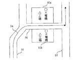
図3は、移動端末装置10の表示ディスプレイに表示される地図データの例を示している。
図3では、道路91と道路93との間に○×電機△工場92があり、道路91と道路93とを結ぶ道路はない。
この状態で、図4に示すように移動体1が94に示す軌跡で道路91から道路93に移動した場合には、移動端末装置10では、移動体の移動軌跡94に沿って道路91と道路93の間に新たな道路が存在すると判断し、移動軌跡94に対応させて道路データを追加する更新を行い、また、表示ディスプレイ上に新たな道路を表示する。
この結果、表示ディスプレイに表示される地図データは図5に示す通りとなり、移動体の移動軌跡94に沿って道路91と道路93とを結ぶ新たな道路95が追加表示される。
また、新たな道路95が通ることになった○×電機△工場92は、新たな道路95に沿って二つの閉ループ要素92a、92bに分割され、また、以前の属性である○×電機△工場を引き継ぐように更新され、また、表示ディスプレイ上にもそのように表示される。
Next, the operation of mobile terminal apparatus 10 according to the present embodiment will be outlined.
FIG. 3 shows an example of map data displayed on the display of the mobile terminal device 10.
In FIG. 3, there is a ◯ electric
In this state, as shown in FIG. 4, when the moving body 1 moves from the
As a result, the map data displayed on the display is as shown in FIG. 5, and a
Further, the XX electric machine △
上述したように、移動端末装置は準天頂衛星から測位情報を受信することにより測位誤差が数10cm以下の高精度測位を行うことができるため、移動体の移動軌跡を正確に特定することができ、この結果、新たな道路を正確な道路位置にて追加することができる。また、後に移動体が当該新たな道路を通行する際にも、地図データ上の正確な位置に新たな道路を表示することができ、また移動体の所在位置を正確に測位することができるため、移動体が新たな道路を通行していることを正確な位置にて表示することができる。 As described above, since the mobile terminal device can perform high-accuracy positioning with a positioning error of several tens of centimeters or less by receiving positioning information from the quasi-zenith satellite, the moving trajectory of the moving object can be accurately specified. As a result, a new road can be added at an accurate road position. In addition, when the moving body passes through the new road later, the new road can be displayed at an accurate position on the map data, and the location of the moving body can be accurately measured. It is possible to display at an accurate position that the moving body is traveling on a new road.
次に、図6を参照して、地図データ更新処理の手順を説明する。
まず、ステップS11において、地図データ更新部109は、地図データ及び移動軌跡情報をマッピング部105より取得する。取得する地図データは表示部106により表示されている地図データである。また、移動軌跡情報には、マッピング部105により当該地図データ上にマッピングされた移動体の移動軌跡が示されている。
次に、ステップS12において、地図データ更新部109は、移動軌跡と重なる地図構成要素データを検出する。図4の例では、移動体の移動軌跡94と重なる○×電機△工場92を検出する。
次に、ステップS13において、地図データ更新部109は、検出した地図構成要素データ(移動軌跡重複地図構成要素データ)の種類を判別する。具体的には、移動軌跡重複地図構成要素データが道路データであるか道路データ以外のデータであるかを判断する(ステップS14)。
道路データである場合には、ステップS15において、新たな道路データを追加する必要がないので、処理を終了する。
一方、道路データでない場合は、移動軌跡重複地図構成要素データのうち移動軌跡と重なる部分を道路データとするように地図データ記憶部108に記憶された地図データを更新する。図4の例では、○×電機△工場92のうち移動軌跡94と重なる部分を新たな道路95とするように地図データを更新する。
次に、ステップS16において、地図データ更新部109は、移動軌跡に沿って移動軌跡重複地図構成要素データを分割するように地図データの更新を行う。図4の例では、○×電機△工場92を要素92aと92bに分割する更新を行う。
Next, the procedure of the map data update process will be described with reference to FIG.
First, in step S <b> 11, the map
Next, in step S12, the map
Next, in step S13, the map
If it is road data, since it is not necessary to add new road data in step S15, the process is terminated.
On the other hand, if it is not road data, the map data stored in the map
Next, in step S16, the map
以上の更新が行われたことにより、新たな道路が正確な道路位置にて表示ディスプレイ上に表示されることになる。 As a result of the above update, a new road is displayed on the display at an accurate road position.
なお、図6のフローチャートでは、移動軌跡と重なる移動軌跡重複地図構成要素データが道路データでない場合には、無条件に地図データを更新することとしたが、移動体の移動速度が所定の速度以上である場合にのみ地図データを更新するようにしてもよい。移動体が道路を外れた場合であっても、単にショッピングセンターの駐車場に駐車し、入口と異なる位置にある出口から出たような場合もあるため、道路を外れてから合流するまでの平均移動速度が所定速度(例えば、15km/h)以下の場合は、新規の道路ではないと判断し、地図データの更新を行わないようにしてもよい。 In the flowchart of FIG. 6, the map data is unconditionally updated when the moving track overlapping map component data that overlaps the moving track is not road data. However, the moving speed of the moving body is equal to or higher than a predetermined speed. The map data may be updated only when Even if the moving object is off the road, it may be just parked in the parking lot of the shopping center and exit from the exit at a different position from the entrance, so the average from the time of leaving the road until joining When the moving speed is a predetermined speed (for example, 15 km / h) or less, it may be determined that the road is not a new road and the map data may not be updated.
また、以上の手順により地図データを更新した場合には、地図データ更新部109は、更新内容を通知する更新内容通知情報を作成し、通信部107、一般通信用アンテナ102を介して地図データ管理センター4の地図データ管理装置40に更新内容通知情報を送信してもよい。地図データ管理センター4では、複数の移動端末装置から更新内容通知情報を受信することにより、最新の道路状況を反映した地図データを管理することができる。
In addition, when the map data is updated by the above procedure, the map
更に、移動端末装置は、近隣に存在する他の移動体の移動端末装置に更新内容通知情報を送信し、近隣の移動端末装置間で最新の道路情報を共有するようにしてもよい。この場合に、他の移動端末装置より更新内容通知情報を受信した移動端末装置が、更に、受信した更新内容通知情報を近隣の移動端末装置に送信することにより更新内容通知情報を順に伝播させていくことも可能である。 Furthermore, the mobile terminal device may transmit update content notification information to mobile terminal devices of other mobile units existing in the vicinity, and share the latest road information between the mobile terminal devices in the vicinity. In this case, the mobile terminal device that has received the update content notification information from another mobile terminal device further propagates the update content notification information in order by transmitting the received update content notification information to the neighboring mobile terminal device. It is also possible to go.
また、以上の説明では、地図データ記憶部に記憶された地図データは書換えが可能であることを前提としたが、地図データの書換えができない場合であってもよい。この場合には、地図データ更新部が更新内容を記憶し、更新が行われたエリアの地図データを表示する場合には、地図データ記憶部に記憶されている地図データに地図データ更新部に記憶された更新内容を重畳させて表示する。 In the above description, it is assumed that the map data stored in the map data storage unit can be rewritten. However, the map data may not be rewritten. In this case, when the map data update unit stores the update contents and displays the map data of the updated area, the map data stored in the map data storage unit is stored in the map data update unit. The updated contents are displayed in a superimposed manner.
また、準天頂衛星はGPS衛星として機能することも可能であり、他のGPS衛星とともに測位情報を配信してもよい。この場合には、移動端末装置は3機以上のGPS衛星及び準天頂衛星からの測位情報と準天頂衛星からの補正情報に基づき移動体の所在位置を測位する。 Further, the quasi-zenith satellite can also function as a GPS satellite, and positioning information may be distributed together with other GPS satellites. In this case, the mobile terminal device measures the location of the moving body based on positioning information from three or more GPS satellites and quasi-zenith satellites and correction information from the quasi-zenith satellites.
また、移動端末装置は、準天頂衛星からの補正情報を受信することで誤差数10cm以下の高精度測位を行うことができるため、道路の道路幅(片側何車線か)、交差点付近の構成(右折レーンがあるか)といったことを認識することもできる。
例えば、地図データ上では片側何車線の道路であるかが明らかでない道路を移動体が走行する場合に、前回走行した位置から数m右または左にずれた位置で当該道路を走行すれば、移動端末装置では前回の走行位置からの差異を認識することができ、移動体が当該道路を複数回走行すれば、移動端末装置では当該道路が何車線の道路であるかを推定することができる。これにより、当該道路を表示ディスプレイに表示する際に何車線の道路であるかといった付加的な情報も表示することができる。
また、移動体がある交差点を右折する場合の走行位置と直進する場合の走行位置とが異なっている場合、すなわち、右折する際には数m右の位置を走行している場合は、移動端末装置ではこの走行位置の差異を認識し、その交差点付近には右折レーンが存在すると推定することができる。これにより、当該交差点付近に右折レーンが存在するといった付加的な情報も表示することができる。
In addition, since the mobile terminal device can perform high-accuracy positioning with an error of 10 cm or less by receiving correction information from the quasi-zenith satellite, the road width of the road (how many lanes on one side), the configuration near the intersection ( It is also possible to recognize that there is a right turn lane).
For example, when a moving body travels on a road whose map data does not clearly show the number of lanes on one side, if the road travels at a position that is shifted to the right or left by several meters from the last traveled position, The terminal device can recognize a difference from the previous travel position, and if the mobile body travels the road a plurality of times, the mobile terminal device can estimate how many lanes the road is. Thereby, when displaying the said road on a display display, additional information, such as how many lanes a road is, can also be displayed.
In addition, when the travel position when the mobile body makes a right turn at a certain intersection is different from the travel position when going straight, that is, when traveling right several meters when making a right turn, the mobile terminal The apparatus recognizes this difference in travel position and can estimate that a right turn lane exists near the intersection. Thereby, additional information that a right turn lane exists in the vicinity of the intersection can also be displayed.
また、道路以外にも通った軌跡により構成される閉ループを道路外の走行可能個所として地図データに記録することも可能である。例えば、ショッピングセンター等の駐車場内に進入した後に車両が走行する軌跡を用いて、駐車場範囲が走行可能であることが記録できる。
また、これを応用して、業務車両が工場内や施設内の走行可能個所をくまなく走行すると、その工場や施設の内部で車両が走行できる範囲が地図データに追加して記録できる。
It is also possible to record in the map data a closed loop constituted by a trajectory that has passed other than the road as a place where the vehicle can travel outside the road. For example, it is possible to record that the parking lot range can be traveled using a trajectory that the vehicle travels after entering a parking lot such as a shopping center.
In addition, by applying this, when the business vehicle travels through the places where the vehicle can travel within the factory or facility, the range in which the vehicle can travel within the factory or facility can be added to the map data and recorded.
このように、本実施の形態によれば、準天頂衛星からの補正情報を用いた高精度測位を行うことにより移動体の移動軌跡を正確に特定することができ、移動体が道路でない位置を通行した場合にも、新たな道路を正確な道路位置にて地図データに反映することができる。 As described above, according to the present embodiment, it is possible to accurately specify the movement trajectory of the moving object by performing high-precision positioning using the correction information from the quasi-zenith satellite, and the position where the moving object is not a road is determined. Even when the vehicle passes, a new road can be reflected in the map data at an accurate road position.
次に、本実施の形態における移動端末装置及び地図データ管理方法の特徴を以下に再言する。 Next, the characteristics of the mobile terminal device and the map data management method in the present embodiment will be described again below.
本実施の形態において、移動端末装置は、
移動体に配置され、地図データを保有する移動端末装置であって、
道路を含む複数種の地図構成要素を示す複数種の地図構成要素データを有する地図データを記憶する地図データ記憶部と、
測位情報及び測位情報を補正するための補正情報を用いて移動体の所在位置を測位する測位部と、
前記測位部の測位結果に基づき移動体の所在位置を地図データ上にマッピングするマッピング部と、
前記マッピング部によるマッピング結果に従い移動体の移動軌跡を地図データ上で特定し、少なくとも一部が移動軌跡と重なる地図構成要素データを移動軌跡重複地図構成要素データとして検出し、検出した移動軌跡重複地図構成要素データの種類を判断し、移動軌跡重複地図構成要素データが道路を示す地図構成要素データでない場合に移動軌跡重複地図構成要素データのうちの移動軌跡と重なる部分を道路を示す地図構成要素データに更新する地図データ更新部とを有することを特徴とする。
In the present embodiment, the mobile terminal device
A mobile terminal device arranged on a mobile body and holding map data,
A map data storage unit for storing map data having a plurality of types of map component data indicating a plurality of types of map components including roads;
A positioning unit that measures the location of the moving body using the positioning information and the correction information for correcting the positioning information;
A mapping unit that maps the location of the moving object on map data based on the positioning result of the positioning unit;
According to the mapping result by the mapping unit, the moving locus of the moving body is specified on the map data, map component data at least partially overlapping the moving locus is detected as the moving locus overlapping map component data, and the detected moving locus overlapping map is detected. Map component data that determines the type of component data and that indicates a road that overlaps the movement track in the moving track overlap map component data when the moving track overlap map component data is not map component data indicating a road And a map data updating unit for updating the data.
前記測位部は、
準天頂衛星より配信された補正情報を用いて移動体の所在位置を測位することを特徴とする。
The positioning unit is
The present invention is characterized in that the location of a moving object is measured using correction information distributed from a quasi-zenith satellite.
前記地図データ更新部は、
移動軌跡重複地図構成要素データのうちの移動軌跡と重なる部分を道路を示す地図構成要素データに更新する場合に、移動軌跡と重なる部分に沿って移動軌跡重複地図構成要素データを分割する更新を行うことを特徴とする。
The map data update unit
When updating the portion of the moving locus overlapping map component data that overlaps the moving locus to the map component data indicating the road, the updating of dividing the moving locus overlapping map component data along the portion overlapping the movement locus is performed. It is characterized by that.
前記地図データ更新部は、
移動体の移動速度が所定速度以上である場合に、移動軌跡重複地図構成要素データのうちの移動軌跡と重なる部分を道路を示す地図構成要素データに更新することを特徴とする。
The map data update unit
When the moving speed of the moving body is equal to or higher than a predetermined speed, a portion of the moving track overlapping map component data that overlaps the moving track is updated to map component data indicating a road.
前記移動端末装置は、更に、
前記地図データ更新部により地図構成要素データに対する更新が行われた場合に、更新後の地図構成要素データを含む地図データを表示する表示部を有することを特徴とする。
The mobile terminal device further includes:
When the map component update data is updated by the map data update unit, the map data update unit includes a display unit that displays map data including the updated map component data.
前記移動端末装置は、更に、
前記地図データ更新部により地図構成要素データに対する更新が行われた場合に、更新内容を通知する更新内容通知情報を外部の装置に対して送信する通信部を有することを特徴とする。
The mobile terminal device further includes:
When update with respect to map component data is performed by the said map data update part, it has a communication part which transmits the update content notification information which notifies update content to an external apparatus, It is characterized by the above-mentioned.
前記通信部は、
他の移動体に配置された他の移動端末装置に対して更新内容通知情報を送信することを特徴とする。
The communication unit is
The update content notification information is transmitted to another mobile terminal device arranged in another mobile body.
前記通信部は、
地図データの管理を行う地図データ管理装置に対して更新内容通知情報を送信することを特徴とする。
The communication unit is
The update content notification information is transmitted to a map data management device that manages map data.
本実施の形態において、地図データ管理方法は、
道路を含む複数種の地図構成要素を示す複数種の地図構成要素データを有する地図データを保有する移動体において地図データの管理を行う地図データ管理方法であって、
測位情報及び測位情報を補正するための補正情報を用いて移動体の所在位置を測位する測位ステップと、
前記測位ステップによる測位結果に基づき移動体の所在位置を地図データ上にマッピングするマッピングステップと、
前記マッピングステップによるマッピング結果に従い移動体の移動軌跡を地図データ上で特定し、少なくとも一部が移動軌跡と重なる地図構成要素データを移動軌跡重複地図構成要素データとして検出し、検出した移動軌跡重複地図構成要素データの種類を判断し、移動軌跡重複地図構成要素データが道路を示す地図構成要素データでない場合に移動軌跡重複地図構成要素データのうちの移動軌跡と重なる部分を道路を示す地図構成要素データに更新する地図データ更新ステップとを有することを特徴とする。
In the present embodiment, the map data management method is:
A map data management method for managing map data in a mobile body having map data having a plurality of types of map component data indicating a plurality of types of map components including roads,
A positioning step of positioning the location of the moving body using the positioning information and the correction information for correcting the positioning information;
A mapping step of mapping the location of the moving object on map data based on the positioning result of the positioning step;
According to the mapping result of the mapping step, the moving locus of the moving body is specified on the map data, map component data at least partially overlapping the moving locus is detected as the moving locus overlapping map component data, and the detected moving locus overlapping map is detected. Map component data that determines the type of component data and that indicates a road that overlaps the movement track in the moving track overlap map component data when the moving track overlap map component data is not map component data indicating a road And a map data updating step for updating.
前記測位ステップは、
準天頂衛星より配信された補正情報を用いて移動体の所在位置を測位することを特徴とする。
The positioning step includes
The present invention is characterized in that the location of a moving object is measured using correction information distributed from a quasi-zenith satellite.
実施の形態2.
本実施の形態では、特定の区間に複数の移動ルートが存在する場合に、複数の移動ルートのそれぞれについて予想通行時間を求め、予想通行時間が最も短い移動ルートを選択し通知する場合について説明する。
Embodiment 2. FIG.
In the present embodiment, a case will be described in which when there are a plurality of travel routes in a specific section, the expected travel time is obtained for each of the plurality of travel routes, and the travel route with the shortest predicted travel time is selected and notified. .
例えば、道路を直進しようとしている車輌が交差点付近で右折車の列に入ってしまい、このため前の車輌(右折車)が右折するまで動けない場合がある。このような場合に、右折車の列から抜け出そうとして車線変更を行うと、接触事故等の危険なことが起こる場合がある。
このため、本実施の形態では、過去の走行経験に基づく学習効果により最も短い時間で通行可能な移動ルートを運転手に知らせる仕組み、すなわち、車輌がある道路を通行した際に通行するのに要した通行時間を記憶し、再度その道路を通行するときに最も通行時間が短い移動ルートを運転手に通知する仕組みについて説明する。
For example, a vehicle going straight on a road may enter a right-turn car line near an intersection, and therefore may not move until the previous vehicle (right-turn car) turns right. In such a case, if a lane change is made in order to get out of the line of a right turn vehicle, a dangerous situation such as a contact accident may occur.
For this reason, in the present embodiment, a mechanism for notifying the driver of the travel route that can be traveled in the shortest time based on the learning effect based on the past traveling experience, that is, necessary for traveling when the vehicle travels on a certain road. A mechanism for storing the travel time and notifying the driver of the travel route with the shortest travel time when traveling on the road again will be described.
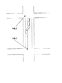
図7は、本実施の形態で対象とする道路の例を示しており、A地点からB地点までの区間に複数の移動ルートとして複数の車線が存在する道路を示している。なお、移動ルート(車線)の選択を行う区間、すなわち、図7の例では、A地点からB地点までの区間をルート選択対象区間という。
なお、本実施の形態においても、準天頂衛星から補正情報を配信することで誤差数10cm以下の高精度測位を行うことができ、この結果、複数車線のそれぞれを正確に識別できることを前提としている。
FIG. 7 shows an example of a road targeted in the present embodiment, and shows a road having a plurality of lanes as a plurality of travel routes in a section from point A to point B. It should be noted that the section in which the travel route (lane) is selected, that is, the section from point A to point B is referred to as a route selection target section in the example of FIG.
In this embodiment as well, it is assumed that high-precision positioning with an error number of 10 cm or less can be performed by distributing correction information from the quasi-zenith satellite, and as a result, each of a plurality of lanes can be accurately identified. .
図8は、本実施の形態に係る移動端末装置10の構成例を示すブロック図である。
図8において、101〜108及び110は図2において示したものと同様である。
また、実施の形態1と同様に、衛星受信部103は、GPS衛星2から測位情報を受信するとともに準天頂衛星3から補正情報を受信し、測位部104は測位情報及び補正情報に基づいて移動体1の所在位置を高精度に測位する。また、準天頂衛星が測位情報も配信する場合には、準天頂衛星からの測位情報を用いていもよい。
また、表示部106は、移動ルート選択部114により選択された移動ルート(車線)を通知するための表示を行う。
FIG. 8 is a block diagram showing a configuration example of the mobile terminal apparatus 10 according to the present embodiment.
8, 101 to 108 and 110 are the same as those shown in FIG.
Similarly to the first embodiment, the
In addition, the
通行時間計測部111は、移動体がルート選択対象区間を通行する度に移動ルート(車線)ごとに通行時間を計測する。
予想通行時間算出部112は、通行時間計測部111により計測された通行時間に基づき、移動ルート(車線)ごとに予想通行時間を算出する。予想通行時間は、移動体がある移動ルート(車線)を通行する際に要すると予想される通行時間であり、例えば、通行時間計測部111により計測された複数の通行時間の平均時間である。
予想通行時間記憶部113は、予想通行時間算出部112により算出された移動ルート(車線)ごとの予想通行時間を記憶する。
移動ルート選択部114は、移動体がルート選択対象区間を通行しようとするとき、又はルート選択対象区間を通行中に複数の移動ルート(車線)の中から予想通行時間が最も短い移動ルート(車線)を選択する。
音声出力部115は、移動ルート選択部114により選択された移動ルート(車線)を音声で通知する音声ガイダンスを出力する。
The travel
The predicted traffic
The predicted travel
The travel route selection unit 114 is configured to select a travel route (lane that has the shortest expected travel time from a plurality of travel routes (lanes) when the mobile body is about to travel through the route selection target section or while traveling through the route selection target section. ) Is selected.
The
移動端末装置10は、図示していないが、例えばマイクロプロセッサ等のCPU、半導体メモリ等や磁気ディスク等の記録手段、及び通信手段を有する計算機により実現することができる。記録手段には、移動端末装置10に含まれる各構成要素の機能を実現するプログラムが記録されており、CPUがこれらのプログラムを読み込むことにより移動端末装置10の動作を制御し、各構成要素の機能を実現することができる。
なお、これらのプログラムを計算機で読みとり可能な記録媒体に記録することも可能である。更には、これらのプログラムを通信網を介して送信し、送信先でこれらのプログラムをインストールすることも可能である。
Although not shown, the mobile terminal device 10 can be realized by a computer having a CPU such as a microprocessor, a recording unit such as a semiconductor memory or a magnetic disk, and a communication unit. In the recording means, a program for realizing the function of each component included in the mobile terminal device 10 is recorded. The CPU reads these programs to control the operation of the mobile terminal device 10, and Function can be realized.
These programs can also be recorded on a recording medium that can be read by a computer. Furthermore, it is also possible to transmit these programs via a communication network and install these programs at the transmission destination.
上述したように、本実施の形態においても、移動端末装置10はGPS衛星2からの測位情報及び準天頂衛星3からの補正情報に基づいて誤差数10cm以下の高精度測位を行うことができる。このため、移動体がルート選択対象区間を通行しているときに、複数の移動ルート(車線)のうちのどの移動ルート(車線)を通行しているかを判断することができ、通行時間計測部111は移動体がルート選択対象区間を通行する度に移動ルート(車線)ごとに通行時間を計測することができる。
この結果、通行時間計測部111が移動ルート(車線)ごとに計測した通行時間に基づき予想通行時間算出部112は移動ルート(車線)ごとに予想通行時間を算出することができる。
As described above, also in the present embodiment, the mobile terminal apparatus 10 can perform high-precision positioning with an error number of 10 cm or less based on the positioning information from the GPS satellite 2 and the correction information from the quasi-zenith satellite 3. For this reason, when the moving body is passing the route selection target section, it can be determined which of the plurality of moving routes (lanes) the moving route (lane) is passing through, and the transit
As a result, based on the travel time measured for each travel route (lane) by the travel
図9は、予想通行時間記憶部113に記憶された記憶内容の例を示す。
図9では、図7に示したA地点からB地点までの予想通行時間を車線ごとに時間帯に分けて記憶している例を示している。また、各車線の予想通行時間は、通行時間計測部111により計測された通行時間の平均時間である。
FIG. 9 shows an example of the stored contents stored in the expected travel
FIG. 9 shows an example in which the estimated traffic time from point A to point B shown in FIG. 7 is stored for each lane divided into time zones. Further, the expected traffic time of each lane is the average time of the traffic time measured by the traffic
移動ルート選択部114は、移動体が図7に示すA地点に差しかかるとき、または、A地点からB地点の間の区間にあるときに、現在時刻に対応する時間帯の予想通行時間を各車線について参照し、予想通行時間の短い車線を選択する。
そして、表示部106が移動ルート選択部114により選択された車線を表示ディスプレイ上に図10に示す例のように表示する。図10では、現在時刻が10時34分なので左車線の方が予想通行時間が短く、このため左車線が選択され、表示ディスプレイに左車線を走行するよう指示するガイダンスが表示される。
また、同時に、音声出力部115から左車線を走行するよう指示する音声ガイダンスを出力してもよい。
The moving route selection unit 114 sets the estimated travel time of the time zone corresponding to the current time when the moving object approaches the point A shown in FIG. 7 or in the section between the point A and the point B. Refer to the lane and select the lane with the shortest expected travel time.
And the
At the same time, voice guidance for instructing to travel in the left lane may be output from the
次に、移動ルート(車線)の選択手順を図11のフローチャートを用いて説明する。
まず、ステップS21において、移動ルート選択部114はマッピング部105より移動体の所在位置を示す所在位置情報を取得する。
次に、ステップS22において、移動体の所在位置がルート選択実行エリア内かどうかを判断する。ルート選択実行エリアとは移動ルートの選択処理を開始すべきエリアであり、ルート選択対象区間の開始点の手前所定位置から終了点の手前所定位置までのエリアである。図7に示した例では、例えば、A地点の手前100mからB地点の手前100mまでのエリアをルート選択実行エリアとする。なお、移動ルート選択部114はルート選択実行エリアの位置情報を保有しており、移動体の所在位置情報と比較することにより移動体の所在位置がルート選択実行エリア内であるか否かを判断する。
移動体の所在位置がルート選択実行エリア外であれば、移動ルート(車線)の選択を行わないため、処理を終了する。
一方、移動体の所在位置がルート選択実行エリア内であれば、ステップS23において、予想通行時間記憶部113の記憶内容を参照し、対象となるルート選択対象区間について予想通行時間の最も短い移動ルート(車線)を選択する。また、予想通行時間記憶部113が時間帯ごとに予想通行時間を記憶している場合は、現在時刻に対応する時間帯について予想通行時間が最も短い移動ルート(車線)を選択する。
次に、ステップS24において、選択した移動ルート(車線)を表示部106、音声出力部115に通知し、表示部106、音声出力部115から選択した移動ルート(車線)を通知するガイダンスを出力させる。
Next, a procedure for selecting a travel route (lane) will be described with reference to the flowchart of FIG.
First, in step S <b> 21, the movement route selection unit 114 acquires location position information indicating the location of the moving object from the
Next, in step S22, it is determined whether the location of the moving object is within the route selection execution area. The route selection execution area is an area where the moving route selection process should be started, and is an area from a predetermined position before the start point of the route selection target section to a predetermined position before the end point. In the example illustrated in FIG. 7, for example, an area from 100 m before point A to 100 m before point B is set as a route selection execution area. Note that the moving route selection unit 114 holds the position information of the route selection execution area, and determines whether the location of the moving object is within the route selection execution area by comparing with the location information of the moving object. To do.
If the location of the moving body is outside the route selection execution area, the moving route (lane) is not selected, and the process ends.
On the other hand, if the location of the moving body is within the route selection execution area, in step S23, the stored content of the predicted travel
Next, in step S24, the selected travel route (lane) is notified to the
このように、本実施の形態によれば、準天頂衛星からの補正情報を用いた高精度測位を行うことにより移動ルートごとの通行時間を計測することができ、移動ルートごとの通行時間に基づく予想通行時間を用いて最も早く通行できると考えられる移動ルートを選択することができる。 Thus, according to the present embodiment, it is possible to measure the travel time for each travel route by performing high-precision positioning using correction information from the quasi-zenith satellite, and based on the travel time for each travel route. It is possible to select a travel route that is considered to be able to travel the earliest using the estimated travel time.
なお、移動端末装置は、選択した移動ルートを通知する移動ルート通知情報を近隣に存在する他の移動体の移動端末装置に送信し、近隣の移動端末装置間で移動ルート通知情報を共有するようにしてもよい。この場合に、他の移動端末装置より移動ルート通知情報を受信した移動端末装置が、更に、受信した移動ルート通知情報を近隣の移動端末装置に送信することにより移動ルート通知情報を順に伝播させていくことも可能である。 The mobile terminal device transmits the travel route notification information for notifying the selected travel route to the mobile terminal devices of other mobile units existing in the vicinity so that the mobile route notification information is shared between the neighboring mobile terminal devices. It may be. In this case, the mobile terminal device that has received the travel route notification information from another mobile terminal device further propagates the travel route notification information in order by transmitting the received travel route notification information to neighboring mobile terminal devices. It is also possible to go.
また、移動端末装置は、予想通行時間記憶部に記憶された予想通行時間を通知する予想通行時間通知情報を近隣に存在する他の移動体の移動端末装置に送信し、近隣の移動端末装置間で予想通行時間通知情報を共有するようにしてもよい。この場合に、他の移動端末装置より予想通行時間通知情報を受信した移動端末装置が、更に、受信した予想通行時間通知情報を近隣の移動端末装置に送信することにより予想通行時間通知情報を順に伝播させていくことも可能である。 In addition, the mobile terminal device transmits the expected traffic time notification information for notifying the predicted traffic time stored in the predicted traffic time storage unit to the mobile terminal device of another mobile body existing in the vicinity, and between the mobile terminal devices in the vicinity May share the expected transit time notification information. In this case, the mobile terminal device that has received the expected transit time notification information from another mobile terminal device further transmits the received expected transit time notification information to neighboring mobile terminal devices, thereby sequentially changing the expected transit time notification information. It is also possible to propagate.
また、以上では、移動ルートとして、同一道路に含まれる各車線を例にして説明したが、例えば、図12に示すようなA地点からB地点までに複数の道路が存在する場合の各道路を移動ルートとし、当該複数の道路について予想通行時間に基づき移動ルートを選択するようにしてもよい。 In the above description, each lane included in the same road is described as an example of the travel route. For example, each road when there are a plurality of roads from point A to point B as shown in FIG. The travel route may be selected and the travel route may be selected for the plurality of roads based on the expected travel time.
次に、本実施の形態における移動端末装置及び地図データ管理方法の特徴を以下に再言する。 Next, the characteristics of the mobile terminal device and the map data management method in the present embodiment will be described again below.
本実施の形態において、移動端末装置は、
移動体に配置され、地図データを保有する移動端末装置であって、
複数の移動ルートが存在する特定区間について、移動ルートごとに予想通行時間を記憶する予想通行時間記憶部と、
特定区間を含むエリアの地図データを記憶する地図データ記憶部と、
移動体の所在位置を測位する測位部と、
前記測位部の測位結果に基づき移動体の所在位置を地図データ上にマッピングするマッピング部と、
前記マッピング部によるマッピング結果に基づき移動体が特定区間内及び特定区間から所定距離内のいずれかに所在するか否かを判断し、移動体が特定区間内及び特定区間から所定距離内のいずれかに所在すると判断した場合に前記予想通行時間記憶部に記憶された移動ルートごとの予想通行時間に基づき複数の移動ルートの中から特定の移動ルートを選択する移動ルート選択部と、
前記移動ルート選択部により選択された移動ルートを通知する移動ルート通知情報を出力する出力部とを有することを特徴とする。
In the present embodiment, the mobile terminal device
A mobile terminal device arranged on a mobile body and holding map data,
For a specific section in which a plurality of travel routes exist, an expected travel time storage unit that stores an expected travel time for each travel route;
A map data storage unit for storing map data of an area including a specific section;
A positioning unit for positioning the location of the moving object;
A mapping unit that maps the location of the moving object on map data based on the positioning result of the positioning unit;
Based on the mapping result by the mapping unit, it is determined whether the moving body is located within the specific section and within the predetermined distance from the specific section, and the mobile body is either within the specific section or within the predetermined distance from the specific section. A travel route selection unit that selects a specific travel route from a plurality of travel routes based on the predicted travel time for each travel route stored in the predicted travel time storage unit when it is determined that
And an output unit for outputting travel route notification information for notifying the travel route selected by the travel route selection unit.
前記予想通行時間記憶部は、
移動ルートごとに時間帯別の予想通行時間を記憶し、
前記移動ルート選択部は、
移動体が特定区間内及び特定区間から所定距離内のいずれかに所在すると判断した場合に、現在時刻に対応する時間帯の予想通行時間に基づき複数の移動ルートの中から特定の移動ルートを選択することを特徴とする。
The expected transit time storage unit is
Memorize the expected travel time by time zone for each travel route,
The travel route selection unit
Select a specific travel route from multiple travel routes based on the expected travel time in the time zone corresponding to the current time when it is determined that the mobile object is located within the specific section or within a predetermined distance from the specific section It is characterized by doing.
前記移動端末装置は、更に、
移動体が特定区間内のいずれかの移動ルートを通行する度に、移動体が当該移動ルートを通行するのに要した通行時間を計測する通行時間計測部と、
前記通行時間計測部により計測された通行時間に基づき予想通行時間を算出する予想通行時間算出部とを有し、
前記予想通行時間記憶部は、
前記予想通行時間算出部により算出された予想通行時間を移動ルートごとに記憶することを特徴とする。
The mobile terminal device further includes:
A travel time measuring unit that measures the travel time required for the mobile body to travel through the travel route each time the mobile body travels through any travel route in the specific section;
An expected transit time calculating unit that calculates an expected transit time based on the transit time measured by the transit time measuring unit;
The expected transit time storage unit is
The predicted travel time calculated by the predicted travel time calculation unit is stored for each travel route.
前記予想通行時間記憶部は、
複数の走行車線が存在する道路の特定区間について、走行車線ごとに予想通行時間を記憶し、
前記移動ルート選択部は、
移動体が特定区間内及び特定区間から所定距離内のいずれかに所在すると判断した場合に、前記予想通行時間記憶部に記憶された走行車線ごとの予想通行時間に基づき複数の走行車線の中から特定の走行車線を選択し、
前記出力部は、
前記移動ルート選択部により選択された走行車線を通知する移動ルート通知情報を出力することを特徴とする。
The expected transit time storage unit is
For a specific section of a road with multiple lanes, store the expected travel time for each lane,
The travel route selection unit
When it is determined that the mobile body is located within the specific section or within a predetermined distance from the specific section, the mobile body is selected from a plurality of travel lanes based on the predicted travel time for each travel lane stored in the predicted travel time storage unit. Select a specific lane,
The output unit is
Travel route notification information for notifying the travel lane selected by the travel route selection unit is output.
前記移動端末装置は、更に、
他の移動体に配置された他の移動端末装置に対して移動ルート通知情報を送信する通信部を有することを特徴とする。
The mobile terminal device further includes:
It has the communication part which transmits movement route notification information with respect to the other mobile terminal device arrange | positioned at another mobile body, It is characterized by the above-mentioned.
前記移動端末装置は、更に、
前記予想通行時間記憶部に記憶された移動ルートごとの予想通行時間を通知する予想通行時間通知情報を外部の装置に対して送信する通信部を有することを特徴とする。
The mobile terminal device further includes:
It has a communication part which transmits the expected traffic time notification information which notifies the predicted traffic time for every moving route memorized by the predicted traffic time storage part to an external device.
前記通信部は、
他の移動体に配置された他の移動端末装置に対して予想通行時間通知情報を送信することを特徴とする。
The communication unit is
It is characterized in that the expected transit time notification information is transmitted to another mobile terminal device arranged in another mobile body.
前記通信部は、
地図データの管理を行う地図データ管理装置に対して予想通行時間通知情報を送信することを特徴とする。
The communication unit is
It is characterized by transmitting expected traffic time notification information to a map data management device that manages map data.
本実施の形態において、地図データ管理方法は、
地図データを保有する移動体において地図データの管理を行う地図データ管理方法であって、
複数の移動ルートが存在する特定区間について、移動ルートごとに予想通行時間を記憶する予想通行時間記憶ステップと、
移動体の所在位置を測位する測位ステップと、
前記測位ステップによる測位結果に基づき移動体の所在位置を地図データ上にマッピングするマッピングステップと、
前記マッピングステップによるマッピング結果に基づき移動体が特定区間内及び特定区間から所定距離内のいずれかに所在するか否かを判断し、移動体が特定区間内及び特定区間から所定距離内のいずれかに所在すると判断した場合に前記予想通行時間記憶ステップにより記憶された移動ルートごとの予想通行時間に基づき複数の移動ルートの中から特定の移動ルートを選択する移動ルート選択ステップと、
前記移動ルート選択ステップにより選択された移動ルートを通知する移動ルート通知情報を出力する出力ステップとを有することを特徴とする。
In the present embodiment, the map data management method is:
A map data management method for managing map data in a mobile object having map data,
For a specific section where a plurality of travel routes exist, an expected travel time storage step for storing an expected travel time for each travel route;
A positioning step for positioning the location of the moving object;
A mapping step of mapping the location of the moving object on map data based on the positioning result of the positioning step;
Based on the mapping result of the mapping step, it is determined whether the moving body is located within the specific section and within the predetermined distance from the specific section, and the mobile body is either within the specific section or within the predetermined distance from the specific section. A travel route selection step of selecting a specific travel route from a plurality of travel routes based on the predicted travel time for each travel route stored in the predicted travel time storage step when it is determined that
An output step of outputting travel route notification information for notifying the travel route selected in the travel route selection step.
前記予想通行時間記憶ステップは、
複数の走行車線が存在する道路の特定区間について、走行車線ごとに予想通行時間を記憶し、
前記移動ルート選択ステップは、
移動体が特定区間内及び特定区間から所定距離内のいずれかに所在すると判断した場合に、前記予想通行時間記憶ステップにより記憶された走行車線ごとの予想通行時間に基づき複数の走行車線の中から特定の走行車線を選択し、
前記出力ステップは、
前記移動ルート選択ステップにより選択された走行車線を通知する移動ルート通知情報を出力することを特徴とする。
The estimated transit time storing step includes:
For a specific section of a road with multiple lanes, store the expected travel time for each lane,
The moving route selection step includes:
When it is determined that the mobile body is located within the specific section or within a predetermined distance from the specific section, the mobile body is selected from a plurality of travel lanes based on the predicted travel time for each travel lane stored in the predicted travel time storage step. Select a specific lane,
The output step includes
Travel route notification information for notifying the travel lane selected in the travel route selection step is output.
1 移動体、2 GPS衛星、3 準天頂衛星、4 地図データ管理センター、10 移動端末装置、40 地図データ管理装置、101 衛星受信用アンテナ、102 一般通信用アンテナ、103 衛星受信部、104 測位部、105 マッピング部、106 表示部、107 通信部、108 地図データ記憶部、109 地図データ更新部、110 入力部、111 通行時間計測部、112 予想通行時間算出部、113 予想通行時間記憶部、114 移動ルート選択部、115 音声出力部。 DESCRIPTION OF SYMBOLS 1 Mobile body, 2 GPS satellite, 3 Quasi-zenith satellite, 4 Map data management center, 10 Mobile terminal device, 40 Map data management device, 101 Satellite reception antenna, 102 General communication antenna, 103 Satellite reception part, 104 Positioning part , 105 Mapping unit, 106 Display unit, 107 Communication unit, 108 Map data storage unit, 109 Map data update unit, 110 Input unit, 111 Traffic time measurement unit, 112 Expected traffic time calculation unit, 113 Expected traffic time storage unit, 114 Travel route selection unit, 115 voice output unit.
Claims (15)
複数の走行可能な移動ルートが存在する特定区間について、移動ルートごとに予想通行時間を記憶する予想通行時間記憶部と、
特定区間を含むエリアの地図データを記憶する地図データ記憶部と、
移動体の所在位置を測位する測位部と、
前記測位部の測位結果に基づき移動体の所在位置を地図データ上にマッピングするマッピング部と、
前記マッピング部によるマッピング結果に基づき移動体が特定区間内及び特定区間から所定距離内のいずれかに所在するか否かを判断し、移動体が特定区間内及び特定区間から所定距離内のいずれかに所在すると判断した場合に前記予想通行時間記憶部に記憶された移動ルートごとの予想通行時間に基づき複数の走行可能な移動ルートの中から特定の移動ルートを選択する移動ルート選択部と、
前記移動ルート選択部により選択された移動ルートを通知する移動ルート通知情報を、他の移動体に配置された他の移動端末装置に対して送信し、他の移動端末装置に更に移動ルート通知情報を別の移動端末装置へ送信させることにより移動ルート通知情報を伝播させる通信部とを有し、
特定区間に複数の走行可能な車線がある場合に、当該複数の走行可能な車線を前記複数の走行可能な移動ルートとして扱うことを特徴とする移動端末装置。 A mobile terminal device arranged on a mobile body and holding map data,
For a specific section where there are a plurality of travel routes that can travel, an expected travel time storage unit that stores an expected travel time for each travel route;
A map data storage unit for storing map data of an area including a specific section;
A positioning unit for positioning the location of the moving object;
A mapping unit that maps the location of the moving object on map data based on the positioning result of the positioning unit;
Based on the mapping result by the mapping unit, it is determined whether the moving body is located within the specific section and within the predetermined distance from the specific section, and the mobile body is either within the specific section or within the predetermined distance from the specific section. A travel route selection unit that selects a specific travel route from a plurality of travel routes that can be traveled based on the predicted travel time for each travel route stored in the predicted travel time storage unit when it is determined that
The travel route notification information for notifying the travel route selected by the travel route selection unit is transmitted to another mobile terminal device arranged in another mobile body, and the travel route notification information is further transmitted to the other mobile terminal device. A communication unit for propagating the travel route notification information by transmitting to another mobile terminal device,
When there are a plurality of lanes that can travel in a specific section, the plurality of lanes that can be traveled are handled as the plurality of travel routes that can be traveled.
移動体が特定区間内のいずれかの移動ルートを通行する度に、移動体が当該移動ルートを通行するのに要した通行時間を計測する通行時間計測部と、
前記通行時間計測部により計測された通行時間に基づき予想通行時間を算出する予想通行時間算出部とを有し、
前記予想通行時間記憶部は、
前記予想通行時間算出部により算出された予想通行時間を移動ルートごとに記憶することを特徴とする請求項1に記載の移動端末装置。 The mobile terminal device further includes:
A travel time measuring unit that measures the travel time required for the mobile body to travel through the travel route each time the mobile body travels through any travel route in the specific section;
An expected transit time calculating unit that calculates an expected transit time based on the transit time measured by the transit time measuring unit;
The expected transit time storage unit is
The mobile terminal apparatus according to claim 1, wherein the predicted travel time calculated by the predicted travel time calculation unit is stored for each travel route.
前記予想通行時間記憶部に記憶された移動ルートごとの予想通行時間を通知する予想通行時間通知情報を外部の装置に対して送信することを特徴とする請求項1又は2に記載の移動端末装置。 The communication unit is
The mobile terminal apparatus according to claim 1 or 2 , wherein predicted mobile time notification information for notifying the predicted travel time for each travel route stored in the predicted travel time storage unit is transmitted to an external device. .
他の移動体に配置された他の移動端末装置に対して予想通行時間通知情報を送信することを特徴とする請求項3に記載の移動端末装置。 The communication unit is
The mobile terminal apparatus according to claim 3 , wherein the expected transit time notification information is transmitted to another mobile terminal apparatus arranged in another mobile body.
地図データの管理を行う地図データ管理装置に対して予想通行時間通知情報を送信することを特徴とする請求項3に記載の移動端末装置。 The communication unit is
4. The mobile terminal apparatus according to claim 3 , wherein the expected traffic time notification information is transmitted to a map data management apparatus that manages map data.
複数の走行可能な移動ルートが存在する特定区間について、移動ルートごとに予想通行時間を記憶する予想通行時間記憶部と、
特定区間を含むエリアの地図データを記憶する地図データ記憶部と、
移動体の所在位置を測位する測位部と、
前記測位部の測位結果に基づき移動体の所在位置を地図データ上にマッピングするマッピング部と、
前記マッピング部によるマッピング結果に基づき移動体が特定区間内及び特定区間から所定距離内のいずれかに所在するか否かを判断し、移動体が特定区間内及び特定区間から所定距離内のいずれかに所在すると判断した場合に前記予想通行時間記憶部に記憶された移動ルートごとの予想通行時間に基づき複数の走行可能な移動ルートの中から特定の移動ルートを選択する移動ルート選択部と、
前記移動ルート選択部により選択された移動ルートを通知する移動ルート通知情報を出力する出力部と、
移動体が特定区間内のいずれかの移動ルートを通行する度に、移動体が当該移動ルートを通行するのに要した通行時間を計測する通行時間計測部と、
前記通行時間計測部により計測された通行時間に基づき予想通行時間を算出する予想通行時間算出部と、
前記予想通行時間算出部により算出された予想通行時間を通知する予想通行時間通知情報を、他の移動体に配置された他の移動端末装置に対して送信し、他の移動端末装置に更に予想通行時間通知情報を別の移動端末装置へ送信させることにより予想通行時間通知情報を伝播させる通信部とを有し、
前記予想通行時間記憶部は、
前記予想通行時間算出部により算出された予想通行時間を移動ルートごとに記憶し、
特定区間に複数の走行可能な車線がある場合に、当該複数の走行可能な車線を前記複数の走行可能な移動ルートとして扱うことを特徴とする移動端末装置。 A mobile terminal device arranged on a mobile body and holding map data,
For a specific section where there are a plurality of travel routes that can travel, an expected travel time storage unit that stores an expected travel time for each travel route;
A map data storage unit for storing map data of an area including a specific section;
A positioning unit for positioning the location of the moving object;
A mapping unit that maps the location of the moving object on map data based on the positioning result of the positioning unit;
Based on the mapping result by the mapping unit, it is determined whether the moving body is located within the specific section and within the predetermined distance from the specific section, and the mobile body is either within the specific section or within the predetermined distance from the specific section. A travel route selection unit that selects a specific travel route from a plurality of travel routes that can be traveled based on the predicted travel time for each travel route stored in the predicted travel time storage unit when it is determined that
An output unit for outputting travel route notification information for notifying the travel route selected by the travel route selection unit;
A travel time measuring unit that measures the travel time required for the mobile body to travel through the travel route each time the mobile body travels through any travel route in the specific section;
An expected traffic time calculating unit that calculates an expected traffic time based on the traffic time measured by the traffic time measuring unit ;
Expected passage time notification information for notifying the expected passage time calculated by the expected passage time calculation unit is transmitted to another mobile terminal device arranged in another mobile body, and further predicted to the other mobile terminal device. A communication unit for propagating the expected transit time notification information by transmitting the transit time notification information to another mobile terminal device ;
The expected transit time storage unit is
Storing the predicted travel time calculated by the predicted travel time calculation unit for each travel route;
When there are a plurality of lanes that can travel in a specific section, the plurality of lanes that can be traveled are handled as the plurality of travel routes that can be traveled.
他の移動体に配置された他の移動端末装置に対して移動ルート通知情報を送信することを特徴とする請求項6に記載の移動端末装置。 The communication unit
Mobile terminal apparatus according to claim 6, wherein the benzalkonium to send movement route notification information to other other mobile terminal devices disposed in the moving body.
移動ルートごとに時間帯別の予想通行時間を記憶し、
前記移動ルート選択部は、
移動体が特定区間内及び特定区間から所定距離内のいずれかに所在すると判断した場合に、現在時刻に対応する時間帯の予想通行時間に基づき複数の走行可能な移動ルートの中から特定の移動ルートを選択することを特徴とする請求項1から7のいずれかに記載の移動端末装置。 The expected transit time storage unit is
Memorize the expected travel time by time zone for each travel route,
The travel route selection unit
If it is determined that the moving body is located within a specific section or within a predetermined distance from the specific section, a specific movement from a plurality of travel routes that can be traveled based on the expected travel time of the time zone corresponding to the current time mobile terminal apparatus according to any one of 7 to claim 1, wherein selecting a route.
測位情報及び測位情報を補正するための補正情報を用いて移動体の所在位置を測位することを特徴とする請求項1から8のいずれかに記載の移動端末装置。 The positioning unit is
The mobile terminal apparatus according to any one of claims 1 to 8 , wherein the position of the moving body is measured using positioning information and correction information for correcting the positioning information.
移動体の所在位置を0.5メートル以下の精度で測位することを特徴とする請求項1から9のいずれかに記載の移動端末装置。 The positioning unit is
The mobile terminal apparatus according to any one of claims 1 to 9 , wherein the location of the mobile body is measured with an accuracy of 0.5 meters or less.
複数の走行可能な移動ルートが存在する特定区間について、移動ルートごとに予想通行時間を記憶する予想通行時間記憶ステップと、
移動体の所在位置を測位する測位ステップと、
前記測位ステップによる測位結果に基づき移動体の所在位置を地図データ上にマッピングするマッピングステップと、
前記マッピングステップによるマッピング結果に基づき移動体が特定区間内及び特定区間から所定距離内のいずれかに所在するか否かを判断し、移動体が特定区間内及び特定区間から所定距離内のいずれかに所在すると判断した場合に前記予想通行時間記憶ステップにより記憶された移動ルートごとの予想通行時間に基づき複数の走行可能な移動ルートの中から特定の移動ルートを選択する移動ルート選択ステップと、
前記移動ルート選択ステップにより選択された移動ルートを通知する移動ルート通知情報を、他の移動体に配置された他の移動端末装置に対して送信し、他の移動端末装置に更に移動ルート通知情報を別の移動端末装置へ送信させることにより移動ルート通知情報を伝播させる通信ステップとを有し、
特定区間に複数の走行可能な車線がある場合に、当該複数の走行可能な車線を前記複数の走行可能な移動ルートとして扱うことを特徴とする地図データ管理方法。 A map data management method for managing map data in a mobile object having map data,
For a specific section where there are a plurality of travel routes that can be traveled, an expected travel time storage step that stores an expected travel time for each travel route;
A positioning step for positioning the location of the moving object;
A mapping step of mapping the location of the moving object on map data based on the positioning result of the positioning step;
Based on the mapping result of the mapping step, it is determined whether the moving body is located within the specific section and within the predetermined distance from the specific section, and the mobile body is either within the specific section or within the predetermined distance from the specific section. A travel route selection step of selecting a specific travel route from a plurality of travel routes that can be traveled based on the predicted travel time for each travel route stored by the predicted travel time storage step when it is determined that
The travel route notification information for notifying the travel route selected in the travel route selection step is transmitted to another mobile terminal device arranged in another mobile body, and the travel route notification information is further transmitted to the other mobile terminal device. A communication step of propagating the travel route notification information by transmitting the information to another mobile terminal device,
A map data management method characterized by handling a plurality of travelable lanes as the plurality of travelable travel routes when there are a plurality of travelable lanes in a specific section.
複数の走行可能な移動ルートが存在する特定区間について、移動ルートごとに予想通行時間を記憶する予想通行時間記憶ステップと、
移動体の所在位置を測位する測位ステップと、
前記測位ステップによる測位結果に基づき移動体の所在位置を地図データ上にマッピングするマッピングステップと、
前記マッピングステップによるマッピング結果に基づき移動体が特定区間内及び特定区間から所定距離内のいずれかに所在するか否かを判断し、移動体が特定区間内及び特定区間から所定距離内のいずれかに所在すると判断した場合に前記予想通行時間記憶ステップにより記憶された移動ルートごとの予想通行時間に基づき複数の走行可能な移動ルートの中から特定の移動ルートを選択する移動ルート選択ステップと、
前記移動ルート選択ステップにより選択された移動ルートを通知する移動ルート通知情報を出力する出力ステップと、
移動体が特定区間内のいずれかの移動ルートを通行する度に、移動体が当該移動ルートを通行するのに要した通行時間を計測する通行時間計測ステップと、
前記通行時間計測ステップにより計測された通行時間に基づき予想通行時間を算出する予想通行時間算出ステップと、
前記予想通行時間算出ステップにより算出された予想通行時間を通知する予想通行時間通知情報を、他の移動体に配置された他の移動端末装置に対して送信し、他の移動端末装置に更に予想通行時間通知情報を別の移動端末装置へ送信させることにより予想通行時間通知情報を伝播させる通信ステップとを有し、
前記予想通行時間記憶ステップは、
前記予想通行時間算出ステップにより算出された予想通行時間を移動ルートごとに記憶し、
特定区間に複数の走行可能な車線がある場合に、当該複数の走行可能な車線を前記複数の走行可能な移動ルートとして扱うことを特徴とする地図データ管理方法。 A map data management method for managing map data in a mobile object having map data,
For a specific section where there are a plurality of travel routes that can be traveled, an expected travel time storage step that stores an expected travel time for each travel route;
A positioning step for positioning the location of the moving object;
A mapping step of mapping the location of the moving object on map data based on the positioning result of the positioning step;
Based on the mapping result of the mapping step, it is determined whether the moving body is located within the specific section and within the predetermined distance from the specific section, and the mobile body is either within the specific section or within the predetermined distance from the specific section. A travel route selection step of selecting a specific travel route from a plurality of travel routes that can be traveled based on the predicted travel time for each travel route stored by the predicted travel time storage step when it is determined that
An output step of outputting travel route notification information for notifying the travel route selected in the travel route selection step;
A travel time measuring step for measuring a travel time required for the mobile body to travel along the travel route each time the mobile body travels through any travel route in the specific section; and
An expected traffic time calculating step for calculating an expected traffic time based on the traffic time measured by the traffic time measuring step ;
The predicted traffic time notification information for notifying the predicted traffic time calculated in the predicted traffic time calculating step is transmitted to another mobile terminal device arranged in another mobile body, and further predicted to the other mobile terminal device. A communication step for propagating the expected transit time notification information by transmitting the transit time notification information to another mobile terminal device ,
The estimated transit time storing step includes:
Storing the predicted travel time calculated by the predicted travel time calculation step for each travel route;
A map data management method characterized by handling a plurality of travelable lanes as the plurality of travelable travel routes when there are a plurality of travelable lanes in a specific section.
測位情報及び測位情報を補正するための補正情報を用いて移動体の所在位置を測位することを特徴とする請求項12又は13に記載の地図データ管理方法。 The positioning step includes
The map data management method according to claim 12 or 13 , wherein the location of the moving body is measured using the positioning information and the correction information for correcting the positioning information.
移動体の所在位置を0.5メートル以下の精度で測位することを特徴とする請求項12から14のいずれかに記載の地図データ管理方法。 The positioning step includes
The map data management method according to any one of claims 12 to 14 , wherein the location of the moving body is measured with an accuracy of 0.5 meters or less.
Priority Applications (1)
| Application Number | Priority Date | Filing Date | Title |
|---|---|---|---|
| JP2012149309A JP5587366B2 (en) | 2012-07-03 | 2012-07-03 | Mobile terminal device and map data management method |
Applications Claiming Priority (1)
| Application Number | Priority Date | Filing Date | Title |
|---|---|---|---|
| JP2012149309A JP5587366B2 (en) | 2012-07-03 | 2012-07-03 | Mobile terminal device and map data management method |
Related Parent Applications (1)
| Application Number | Title | Priority Date | Filing Date |
|---|---|---|---|
| JP2010144668A Division JP5059170B2 (en) | 2010-06-25 | 2010-06-25 | Mobile terminal device and map data management method |
Publications (2)
| Publication Number | Publication Date |
|---|---|
| JP2012194190A JP2012194190A (en) | 2012-10-11 |
| JP5587366B2 true JP5587366B2 (en) | 2014-09-10 |
Family
ID=47086199
Family Applications (1)
| Application Number | Title | Priority Date | Filing Date |
|---|---|---|---|
| JP2012149309A Expired - Fee Related JP5587366B2 (en) | 2012-07-03 | 2012-07-03 | Mobile terminal device and map data management method |
Country Status (1)
| Country | Link |
|---|---|
| JP (1) | JP5587366B2 (en) |
Families Citing this family (2)
| Publication number | Priority date | Publication date | Assignee | Title |
|---|---|---|---|---|
| DE102015218809A1 (en) * | 2015-09-29 | 2017-03-30 | Continental Teves Ag & Co. Ohg | Method for updating an electronic map of a vehicle |
| KR102112825B1 (en) * | 2017-12-26 | 2020-05-19 | 한국항공우주연구원 | Realtime GNSS Data Correction System, Method and Computer Readable Recording Mediuim |
Family Cites Families (11)
| Publication number | Priority date | Publication date | Assignee | Title |
|---|---|---|---|---|
| JPH0566260A (en) * | 1991-09-06 | 1993-03-19 | Nippondenso Co Ltd | Navigation apparatus |
| JP3214181B2 (en) * | 1993-09-14 | 2001-10-02 | トヨタ自動車株式会社 | Car navigation system |
| US5539645A (en) * | 1993-11-19 | 1996-07-23 | Philips Electronics North America Corporation | Traffic monitoring system with reduced communications requirements |
| JP3584487B2 (en) * | 1994-03-11 | 2004-11-04 | 日産自動車株式会社 | Driving information providing device |
| JP3218935B2 (en) * | 1995-07-25 | 2001-10-15 | 松下電器産業株式会社 | Route search communication device |
| JPH113499A (en) * | 1997-06-10 | 1999-01-06 | Hitachi Ltd | Mobile body management system, mobile body mounting device, base station device and mobile body managing method |
| JP3654009B2 (en) * | 1998-10-08 | 2005-06-02 | 日産自動車株式会社 | Navigation device |
| JP3680243B2 (en) * | 1999-01-20 | 2005-08-10 | トヨタ自動車株式会社 | Runway shape display device and map database recording medium |
| JP2001349735A (en) * | 2000-06-08 | 2001-12-21 | Denso Corp | Route setting device, and navigation system |
| JP2002062149A (en) * | 2000-08-23 | 2002-02-28 | Matsushita Electric Ind Co Ltd | On vehicle position calculator |
| JP2002131412A (en) * | 2000-10-23 | 2002-05-09 | Communication Research Laboratory | Satellite communication positioning system |
-
2012
- 2012-07-03 JP JP2012149309A patent/JP5587366B2/en not_active Expired - Fee Related
Also Published As
| Publication number | Publication date |
|---|---|
| JP2012194190A (en) | 2012-10-11 |
Similar Documents
| Publication | Publication Date | Title |
|---|---|---|
| JP3908647B2 (en) | Mobile terminal device and map data management method | |
| JP4661439B2 (en) | Vehicle navigation device and road map distribution system | |
| JP5082295B2 (en) | Map data providing device | |
| CN110455300B (en) | Navigation method, navigation display device, vehicle and machine readable medium | |
| US9127954B2 (en) | Navigation system, navigation apparatus, and data center | |
| US20140063044A1 (en) | Navigation apparatus and display method thereof | |
| WO2010137309A1 (en) | Vehicle position measurement device and vehicle position measurement method | |
| JP4571887B2 (en) | Navigation system, matching method, route search server, and navigation terminal device | |
| JP2927204B2 (en) | Travel time providing device and route calculation device | |
| JP4627062B2 (en) | Mobile terminal device and map data management method | |
| JP4059193B2 (en) | Navigation device | |
| JP5587366B2 (en) | Mobile terminal device and map data management method | |
| CN107209898B (en) | Server, navigation device, and method for setting transmission exclusion area in advertisement information transmission system | |
| JP4822938B2 (en) | Navigation device | |
| JP5059170B2 (en) | Mobile terminal device and map data management method | |
| JP5188557B2 (en) | Mobile terminal device and map data management method | |
| JPH04138317A (en) | Navigation apparatus utilizing communication between vehicles | |
| JP4560063B2 (en) | Mobile terminal device and map data management method | |
| JP2006202098A (en) | Route bus operation management system and mobile terminal device | |
| EP2729765B1 (en) | Navigation device having dead reckoning navigation functionality and method thereof | |
| JP2019100763A (en) | Passing-each-other difficulty section avoidance system, server device, information display device, and passing-each-other difficulty section avoidance method | |
| JP3964439B2 (en) | Mobile terminal device and map data management method | |
| JP2019075176A (en) | Server device | |
| JP2006337213A (en) | Network data for matching, preparing method of network data for matching, navigation system having network data for matching, path research server, and navigation terminal device | |
| WO2011132498A1 (en) | Current position display device, and current position display method |
Legal Events
| Date | Code | Title | Description |
|---|---|---|---|
| A621 | Written request for application examination |
Free format text: JAPANESE INTERMEDIATE CODE: A621 Effective date: 20120703 |
|
| A131 | Notification of reasons for refusal |
Free format text: JAPANESE INTERMEDIATE CODE: A131 Effective date: 20131105 |
|
| A521 | Written amendment |
Free format text: JAPANESE INTERMEDIATE CODE: A523 Effective date: 20131219 |
|
| A131 | Notification of reasons for refusal |
Free format text: JAPANESE INTERMEDIATE CODE: A131 Effective date: 20140513 |
|
| A521 | Written amendment |
Free format text: JAPANESE INTERMEDIATE CODE: A523 Effective date: 20140630 |
|
| TRDD | Decision of grant or rejection written | ||
| A01 | Written decision to grant a patent or to grant a registration (utility model) |
Free format text: JAPANESE INTERMEDIATE CODE: A01 Effective date: 20140722 |
|
| A61 | First payment of annual fees (during grant procedure) |
Free format text: JAPANESE INTERMEDIATE CODE: A61 Effective date: 20140723 |
|
| R150 | Certificate of patent or registration of utility model |
Ref document number: 5587366 Country of ref document: JP Free format text: JAPANESE INTERMEDIATE CODE: R150 |
|
| R250 | Receipt of annual fees |
Free format text: JAPANESE INTERMEDIATE CODE: R250 |
|
| LAPS | Cancellation because of no payment of annual fees |