JP4778133B2 - Navigation device and method, and recording medium recording navigation software - Google Patents
Navigation device and method, and recording medium recording navigation software Download PDFInfo
- Publication number
- JP4778133B2 JP4778133B2 JP2000183240A JP2000183240A JP4778133B2 JP 4778133 B2 JP4778133 B2 JP 4778133B2 JP 2000183240 A JP2000183240 A JP 2000183240A JP 2000183240 A JP2000183240 A JP 2000183240A JP 4778133 B2 JP4778133 B2 JP 4778133B2
- Authority
- JP
- Japan
- Prior art keywords
- facility
- name
- map
- icon
- displayed
- Prior art date
- Legal status (The legal status is an assumption and is not a legal conclusion. Google has not performed a legal analysis and makes no representation as to the accuracy of the status listed.)
- Expired - Lifetime
Links
Images


Description
【0001】
【発明の属する技術分野】
本発明は、ナビゲーションの技術の改良に係り、特に、施設などの目的地を表示る機能に改良を施したナビゲーション装置及び方法並びにナビゲーション用ソフトウェアを記録した記録媒体に関する。
【0002】
【従来の技術】
近年、デジタル技術の進歩に伴い、自動車などの移動体の道案内を行うナビゲーションの技術が普及している。例えば、車載用ナビゲーションシステムは、CD−ROMやDVD−ROMなどの記録媒体に予め記録された道路などのデータに基づいて、与えられた目的地までの最適な経路を計算し、GPS航法などでリアルタイムに計算する自車位置付近の地図を画面表示しながら、表示画面や合成音声などで右左折などの道案内を行うものである。
【0003】
このようなナビゲーションシステムの利用は、目的地となる施設を設定することから始まるが、通常のシステムは、画面表示された地図をスクロールさせることによって施設を検索できるばかりでなく、目的地の設定を素早く行うことができるように、予め多数の施設の名称をデータベース化して記録しておき、このデータベースを検索することによって、所望の施設を見つけ出す目的地検索の機能が組み込まれている。そして、このように検索された施設は、ユーザが所定の操作を行うことによって、施設が存在する地点の座標や名称を、登録地点リストに地点登録することができた。さらに、地点登録された施設は、リスト表示される施設の名称の中から、ユーザが必要に応じて選択することによって呼び出すことができた。
【0004】
ところで、かかる呼び出し作業をし易くするため、ユーザの入力操作によって、あらかじめ一つ一つの施設にその種類に応じたアイコンを割り振っておき、リスト表示の際にこのアイコンを表示させることによって、目的となる施設を選択する際の目安とすることができた。また、このように割り振られたアイコンは、地図上に施設を表示する際にも、該当地点に表示されるので、地図上での施設の位置や種類の確認を行うことができた。
【0005】
【発明が解決しようとする課題】
ところで、上記のような従来技術においては、地点登録を重ねるうちに、リスト表示される施設の数が多くなり、必要とする施設を探し出して呼び出すことが難しくなる。これに対処するため、全ての施設に、その種類に応じたアイコンを割り振っておき、種類が共通するもの同士をまとめておくことによって、探索の容易化を図ることが考えられる。しかし、これを完全に行なうためには、全ての地点登録を行う際に、ユーザが必ずアイコンを割り振る作業を行わなければならず、非常に面倒である。
【0006】
本発明は、上記のような従来技術の問題点を解決するために提案されたもので、その目的は、施設へのアイコンの割り振りを自動的に行うことによって、ユーザの操作負担の軽減を図るとともに、施設の種類判断や選択の容易化が可能なナビゲーションシステム及び方法並びにナビゲーション用ソフトウェアを記録した記録媒体を提供することにある。
【0007】
【課題を解決するための手段】
上記の目的を達成するため、請求項1記載の発明は、地図を記憶した地図情報記憶手段と、案内すべき経路とともに地図を表示可能な表示手段とを有するナビゲーション装置において、地図上の施設に関する情報であって、施設の名称及び施設の属性を含む施設情報を記憶した施設情報記憶手段と、少なくとも施設の名称の一部を受け付ける入力手段と、前記入力手段により受け付けられた施設の名称に従って、施設名を抽出する施設抽出手段と、前記施設抽出手段により抽出された施設名から、指定された施設名に対応する施設情報を地点登録する地点登録手段と、施設の属性に対応したアイコン情報を記憶するアイコン情報記憶手段と、前記施設抽出手段により抽出された施設名から、指定された施設名に対応する施設周辺の地図を前記表示手段に表示した状態で、当該施設の地点登録要求のみを契機として、当該施設の属性に対応するアイコンを、地図上の当該施設の位置に表示させ、前記地点登録手段により地点登録された後の施設名を前記表示手段に表示する場合に、当該施設の属性に対応するアイコンを、前記表示手段に表示させるアイコン表示制御手段と、を有することを特徴とする。
【0008】
請求項3記載の発明は、請求項1記載の発明を方法の観点から捉えたものであり、コンピュータが、地図を記憶するステップと、案内すべき経路とともに地図を表示手段に表示させるステップとを含むナビゲーション方法において、前記コンピュータが、地図上の施設に関する情報であって、施設の名称及び施設の属性を含む施設情報を記憶するステップと、少なくとも施設の名称の一部を受け付けるステップと、受け付けられた施設の名称に従って、施設名を抽出するステップと、抽出された施設名から、指定された施設名に対応する施設情報をを地点登録するステップと、施設の属性に対応したアイコン情報を記憶するステップと、抽出された施設名から、指定された施設名に対応する施設周辺の地図を前記表示手段に表示した状態で、当該施設の地点登録要求のみを契機として、当該施設の属性に対応するアイコンを、地図上の当該施設の位置に表示させ、地点登録された後の施設名を前記表示手段に表示する場合に、当該施設の属性に対応するアイコンを、前記表示手段に表示させるステップと、を含むことを特徴とする。
請求項4記載の発明は、請求項1又は請求項3記載の発明を、コンピュータによって読み取り可能な記録媒体の観点から捉えたものであり、コンピュータを用いて、地図を記憶させ、案内すべき経路とともに地図を表示手段に表示させるナビゲーション用ソフトウェアを記録した記録媒体において、前記ソフトウェアは前記コンピュータに、地図上の施設に関する情報であって、施設の名称及び施設の属性を含む施設情報を記憶させ、少なくとも施設の名称の一部を受け付けさせ、受け付けられた施設の名称に従って、施設名を抽出させ、抽出された施設名から、指定された施設名に対応する施設情報を地点登録させ、施設の属性に対応したアイコン情報を記憶させ、抽出された施設名から、指定された施設名に対応する施設周辺の地図を前記表示手段に表示させた状態で、当該施設の地点登録要求のみを契機として、当該施設の属性に対応するアイコンを、地図上の当該施設の位置に表示させ、地点登録された後の施設名を前記表示手段に表示する場合に、当該施設の属性に対応するアイコンを、前記表示手段に表示させることを特徴とする。
【0010】
以上のような請求項1、3及び4記載の発明では、従来、ユーザが自らの選択によって行っていたアイコンの割り付けを、通常の地点登録をするだけで自動的に行うことができるので、ユーザの操作を簡略化できる。
【0011】
また、例えば、ナビゲーションの目的地として設定される施設に、その属性に応じたアイコンが自動的に付与されて表示されるので、ユーザがアイコンを割り振る手間をかけずに、アイコン表示による目的地の確認や判別の容易化を図ることができる。さらに、アイコン表示によって、地点登録された施設の呼び出しを容易に行なうことができる。
【0012】
請求項2記載の発明は、請求項1記載のナビゲーション装置において、前記地点登録手段により登録された後の施設名とともに表示されるアイコンは、前記表示手段にリスト表示された施設とともに表示されることを特徴とする。
【0013】
以上のような請求項2記載の発明では、リスト表示される施設とともにアイコンが表示されるので、 ユーザが呼び出したい施設を探しやすくなる。また、割り付けられたアイコンを基準としてリストを並び替えることによって、 呼び出したい施設をさらに探しやすくすることができる。
【0014】
【発明の実施の形態】
次に、本発明の実施の形態について、図面を参照して具体的に説明する。なお、本実施の形態のうち情報処理に関する部分は、典型的には、コンピュータをソフトウェアで制御することで実現される。この場合のソフトウェアは、コンピュータのハードウェアを物理的に活用することで本発明の作用効果を実現するもので、また、従来技術との共通部分には従来技術も適用される。但し、この場合のハードウェアやソフトウェアの種類や構成、ソフトウェアで処理する範囲などは各種変更可能であるため、以下の説明では、本発明及び実施の形態の各機能を実現する仮想的回路ブロックを用いる。
【0015】
〔1.実施の形態の構成〕
本実施の形態は、移動体である自動車に搭載して経路を案内するためのナビゲーション装置(本装置と呼ぶ)と、本装置上で実行されるナビゲーション方法を示すもので、これらを実現するためのナビゲーション用ソフトウェアを記録した記録媒体として把握することもできる。
【0016】
〔1−1.全体構成〕
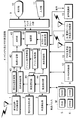
本装置は、図1の機能ブロック図に示すように、絶対位置・方位検出部1と、相対方位検出部2と、車速検出部3と、メインCPU及びその周辺回路4と、メモリ群Mと、ユーザインタフェース部9と、表示部10と、入力部11と、CD−ROM制御部12と、FM多重受信及び処理部13と、光・電波ビーコン受信及び処理部14と、音声認識部15とを備えている。
【0017】
このうち、絶対位置・方位検出部1は、本装置が搭載された自動車(自車と呼ぶ)の現在位置すなわち自車位置について、地表での絶対的な位置座標や方位を計算するために、例えば、GPS衛星から送られてくるGPS電波をアンテナやレシーバなどで受信するための部分である。また、相対方位検出部2は、ジャイロなどを使って自車の相対的な方位を検出するための部分である。また、車速検出部3は、自動車より得られる車速パルスを処理することで自車の速度を計算する部分である。
【0018】
また、メインCPU及びその周辺回路4は、本装置全体を制御する制御回路の役割を果たす部分である。また、メモリ群Mは、本装置の動作に必要な各種のメモリで、例えば、プログラムが格納され、起動時等にメインCPUからアクセスされるROM5、メインプログラムがロードされ、ワークエリアなどを提供するDRAM(ダイナミックRAM)6、電源のOFFからON時にメモリ内容を保持するためのSRAM(スタティックRAM)7(メイン電源OFF時にもバッテリーバックアップされている)、表示部10用のVRAM(VideoRAM)8などを含む。
【0019】
また、表示部10は、地図、操作メニューボタン、施設名リスト、50音パネルなど各種の情報を、図示しない液晶表示画面や音声合成などで出力する部分である。入力部11は、ユーザがフロントパネルやリモコンにおけるスイッチやジョイスティックなどから、命令などの情報を入力するための部分であり、例えば、地図上の所望の地点、メニューボタン、施設名リスト、50音パネルの選択操作入力などを行うことができる。なお、表示部10は、画面に表示された地図上の任意の地点、メニューボタン、施設名リスト、50音パネルなどの項目を、直接指で触るだけで入力部11と同様に入力手段としての役割を果たすことができるタッチパネルとしての機能も有している。また、ユーザインタフェース部9は、I/O制御回路やドライバなどを使って、表示部10及び入力部11と、メインCPU及びその周辺回路4とを結ぶユーザインタフェースである。
【0020】
また、CD−ROM制御部12は、CD−ROMに記録されたデータベースを読み出す手段であり、データベースの内容は、地図データを中心として、例えば、道路のネットワーク構造を表す経路探索用データ、ガソリンスタンドなどのランドマークを表す表示用データなどを含むとともに、施設データを含んでいる。
この施設データは、施設の名称をレコード名とするレコード型であり、そのデータ項目としては、例えば、駐車場、テニスコートなどの施設の種類に関するID(以下、種類IDと呼ぶ)、施設の位置座標等が含まれている。さらに、ROM5に格納され、起動時にDRAM6上に読み込まれるアプリケーションには、メニューボタンや50音パネル等の本装置の操作に必要な基本的な情報の他に、個々の種類IDに応じてあらかじめ定められたアイコンに関する情報であるアイコンテーブルが含まれている。
【0021】
なお、上記のデータベースやプログラム等の情報の格納領域は、自由に設定可能であり、例えば、これらの情報の全部若しくは一部をあらかじめROM5側に格納しても、CD−ROM側に格納してもよい。さらに、記録媒体としては、CD−ROMには限定されない。例えば、DVD−ROM制御部によって読み出されるDVD−ROMであってもよい。
【0022】
また、FM多重受信及び処理部13は、FM放送波やこの放送波に含まれるVICSの交通情報を受信する部分である。さらに、光・電波ビーコン受信及び処理部14は、道路に設置された送信設備の下を通過する際に、光ビーコンや電波ビーコンに含まれるVICSの交通情報を受信する部分である。なお、交通情報は渋滞、事故、規制、工事、目的地までの旅行時間等の情報を含んでいる。さらに、音声認識部15は、ユーザからの発声を入力し、音声を認識する手段である。
【0023】
〔1−2.メインCPU及びその周辺回路の役割〕
さらに、メインCPU及びその周辺回路4は、上記のようなソフトウェアの作用によって、現在位置計算部40と、目的地指定部41と、経路計算部42と、案内部43と、施設抽出部44と、施設選択部45と、地点登録部46と、アイコン検索部47と、アイコン表示制御部48と、スクロール表示制御部49と、描画部50としての役割を果たすように構成されている。
【0024】
このうち現在位置計算部40は、自車の現在位置すなわち自車位置を計算するための手段であり、具体的には、GPS航法測位と自律航法測位とを組み合わせることで自車位置を計算するように構成されている。ここで、GPS航法測位は、人工衛星からの電波に基づいて絶対位置・方位検出部1から得られる情報を使って現在位置を計算するものである。また、自律航法測位は、地磁気及び自車の速度に基づいて相対方位検出部2及び車速検出部3から得られる情報を使って現在位置を計算するものである。
【0025】
また、経路計算部42は、現在の自車位置から、目的地指定部41によって指定された施設にいたる最適な経路を、前記経路探索用データに基づいて計算する手段である。また、案内部43は、経路計算部42によって計算された経路について、現在位置計算部40によって逐次計算される現在位置などに基いて、合成音声や画面表示によって道案内する手段である。
【0026】
施設抽出部44は、ユーザが入力した抽出条件に一致する施設名を、施設データから抽出する手段である。施設選択部45は、施設抽出部44によって抽出された施設名の中から、ユーザが選択した施設を選択する手段である。地点登録部46は、施設選択部45によって選択された施設名に対応する施設データをSRAM7に格納することによって、地点登録を行なう手段である。アイコン検索部47は、施設選択部45によって選択された施設名に対応するアイコンデータを、当該施設の種類ID及びアイコンテーブルを参照してピックアップする手段である。アイコン表示制御部48は、アイコン検索部47によってピックアップされたアイコンを、対応する施設名若しくは施設周辺の地図とともに表示させる手段である。
【0027】
スクロール表示制御部49は、表示部10における画面表示を上下左右に動かして、見たい場所を表示するための制御を行う手段である。描画部50は、他の各部から渡される情報に基づいて、表示部10に表示される表示内容を描画する手段である。
【0028】
〔2.実施の形態の作用〕
上記のように構成された本実施の形態は、次のように作用する。まず、本実施の形態は、絶対位置・方位検出部1、相対方位検出部2、車速検出部3からの情報に基づいて、現在位置計算部40によって計算された自車位置から目的地指定部41によって指定された目的地に至る最適な経路を、経路計算部42が経路探索用データに基づいて計算し、案内部43が合成音声や画面表示によって道案内する機能や、目的地指定部41によって指定された目的地の座標地周辺の地図を検索して表示させる機能といった通常のナビゲーション装置としての機能を有している。
【0029】
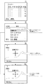
さらに、本実施の形態は、目的地検索及び地点登録に付随したアイコン表示機能を有している。以下、目的地検索の代表例として、施設の名称から検索する場合を、図2及び図3の説明図、図4及び図5のフローチャートを参照して説明する。
【0030】
〔2−1.地点登録〕
まず、検索された目的地の地点登録とともに行なわれるアイコン表示の処理手順について説明する。すなわち、本装置の起動時には、アプリケーションプログラムとともに、アイコンテーブルがDRAM6等における所定の記憶領域(以下、単に「メモリ」と呼ぶ)上に読み込まれる。そして、ユーザの入力操作に従って、図2の▲1▼に示すように、表示部10に50音パネルが表示される。ユーザは、この50音パネルを用いて、例えば、“くらりー”という抽出(検索)条件を入力して検索ボタンを選択する。すると、施設抽出部44によって、施設データの中から、“くらりー”の文字を含む施設名のリストが抽出され、図2の▲2▼に示すように表示部10に表示される。
【0031】
このようにリスト表示された施設名の中から、ユーザが、例えば“近畿クラリー” (種類はテニスコート)を選択すると、施設選択部45によって“近畿クラリー”が選択される(ステップ401)。すると、施設データのレコード名“近畿クラリー”に対応するテニスコートの種類IDがメモリに保持される(ステップ402)。同時に、目的地指定部41によって“近畿クラリー”が指定され、図2の▲3▼に示すように、“近畿クラリー”の座標地を中心とした地図が検索されて表示部10に表示される。
【0032】
このように表示部10に施設周辺の地図表示がなされた状態で、ユーザが地点登録を要求する入力操作を行うと(ステップ403)、アイコン検索部47は、アイコンテーブルを参照して、メモリ上に読み込まれている種類IDと一致するアイコンデータをアイコンテーブルからピックアップし、図2の▲4▼に示すように、アイコン表示制御部48が、表示部10における地図上の目的地にそのアイコン(テニスコートをイメージするようなもの)を表示させる(ステップ404)。また、地点登録部46は、地点登録の要求のあった施設データ(名称、座標、種類ID等)を、SRAM7上の登録地点リストのエリアに格納する(ステップ405)。なお、地点登録された施設データがSRAM7からクリアされるまで、アイコン表示制御部48は、地図上の登録地点にアイコンを表示させる。
【0033】
なお、ステップ403〜405の手順を、以下のように変更してもよい。すなわち、“近畿クラリー”が施設選択部45によって選択された時に、アイコン検索部47が、“近畿クラリー”のレコード内に格納されている種類IDと一致するアイコンデータをアイコンテーブルからピックアップし、そのアイコンをアイコン表示制御部48が、地図上に表示させる。
【0034】
そして、ユーザが地点登録を要求する入力操作を行うと、地点登録部46は、地点登録の要求のあった施設データ(名称、座標、種類ID等)を、SRAM7上の登録地点リストのエリアに格納する。なお、この場合にも、上記と同様に、地点登録された施設データがSRAM7からクリアされるまで、アイコン表示制御部48は、地図上の登録地点にアイコンを表示させる。
【0035】
〔2−2.登録地点リストの呼び出し〕
次に、登録地点リストの呼び出しに対応したアイコン表示の処理手順を、図5のフローチャートを参照して説明する。すなわち、ユーザが登録地点リストの表示要求を入力すると(ステップ501)、アイコン検索部47によって、それぞれの地点の種類IDに一致するアイコンデータがアイコンテーブルからピックアップされる(ステップ502)。そして、図3に示すように、SRAM7上に格納された登録地点リストとともに、それぞれの地点に対応するアイコンが、表示部10に表示される(ステップ503)。このアイコンは、上記のように地図上に表示されたものと同じものとなっている。
【0036】
〔3.実施の形態の効果〕
以上説明したように、本実施の形態では、登録地点リストにおいて、各地点の種類別にアイコンが自動的に設定され表示されるので、ユーザが呼び出したい施設を探しやすくなる。
また、従来、ユーザが自らの選択によって行っていたアイコンの割り付けを、検索操作から通常の地点登録をするだけで自動的に行うことができるので、ユーザの操作を簡略化できる。
また、割り付けられたアイコンを基準として登録地点リストを並び替えることによって、呼び出したい施設をさらに探しやすくすることができる。
【0037】
〔4.他の実施の形態〕
本発明は、上記のような実施の形態に限定されるものではない。例えば、地点登録の際に、SRAM7上に施設データとともにアイコンデータを格納することのよって、施設データとともにアイコンデータを登録、呼び出しできる設定とすることも可能である。
【0038】
また、メニュー表示、項目表示、アイコン表示等の色、形状及び大きさ等の設定は、自由に変更可能である。また、検索のための各項目の内容は、上記の実施の形態に示した例には限定されない。また、目的地として指定する施設は、人工の設備には限らず、自然物や慣習的な地名など、どのようなものであってもよい。
【0039】
また、ユーザによる入力操作を、上記の実施の形態における音声認識部15からの音声入力によって行なうこともできる。さらに、本発明を車載用以外のナビゲーション装置に適用することも可能である。
【0040】
【発明の効果】
以上説明したように、本発明によれば、施設へのアイコンの割り振りを自動的に行うことによって、ユーザの操作負担の軽減を図るとともに、施設の種類判断や選択の容易化が可能なナビゲーションの技術すなわちナビゲーション装置及び方法並びにナビゲーション用ソフトウェアを記録した記録媒体を提供することができる。
【図面の簡単な説明】
【図1】本発明の実施の形態の構成例を示す機能ブロック図。
【図2】図1の実施の形態における地点登録の画面表示例を示す説明図である。
【図3】図1の実施の形態におけるアイコン付きの登録リストの画面表示例を示す説明図である。
【図4】図1の実施の形態における地点登録に対応したアイコン表示の処理手順の一例を示すフローチャートである。
【図5】図1の実施の形態における登録地点リストの呼び出しに対応したアイコン表示の処理手順の一例を示すフローチャートである。
【符号の説明】
1…絶対位置・方位検出部
2…相対方位検出部
3…車速検出部
4…メインCPU及びその周辺回路
M…メモリ群
5…ROM
6…ダイナミックRAM(DRAM)
7…スタチックRAM(SRAM)
8…VideoRAM(VRAM)
9…ユーザインタフェース部
10…表示部
11…入力部
12…CD−ROM制御部
13…FM多重受信及び処理部
14…光・電波ビーコン受信及び処理部
15…音声認識部
40…現在位置計算部
41…目的地指定部
42…経路検索部
43…案内部
44…施設抽出部
45…施設選択部
46…地点登録部
47…アイコン検索部
48…スクロール表示制御部
49…描画部
401以降…手順の各ステップ[0001]
BACKGROUND OF THE INVENTION
The present invention relates to an improvement in navigation technology, and more particularly to a navigation apparatus and method for improving a function for displaying a destination such as a facility, and a recording medium on which navigation software is recorded.
[0002]
[Prior art]
In recent years, with the advancement of digital technology, navigation technology that guides a moving body such as an automobile has become widespread. For example, an in-vehicle navigation system calculates the optimum route to a given destination based on data such as roads recorded in advance on a recording medium such as a CD-ROM or DVD-ROM, and uses GPS navigation or the like. While displaying the map near the vehicle position calculated in real time on the screen, the route guidance such as turning left or right is performed on the display screen or synthesized voice.
[0003]
The use of such a navigation system starts with setting a destination facility, but a normal system can not only search for facilities by scrolling the map displayed on the screen, but also set the destination. In order to be able to perform quickly, the names of a large number of facilities are recorded in a database in advance, and a destination search function for finding a desired facility by searching this database is incorporated. And the facility searched in this way was able to carry out the spot registration of the coordinate and name of the spot where a facility exists to a registration spot list | wrist, when a user performs predetermined | prescribed operation. Furthermore, the registered facility can be called by the user selecting the facility name displayed in the list as necessary.
[0004]
By the way, in order to facilitate such a call work, by assigning an icon corresponding to the type to each facility in advance by a user input operation and displaying this icon at the time of list display, It was possible to use it as a guide when selecting a facility. Moreover, since the icon allocated in this way is displayed at the corresponding point when the facility is displayed on the map, the position and type of the facility on the map can be confirmed.
[0005]
[Problems to be solved by the invention]
By the way, in the prior art as described above, the number of facilities displayed in a list increases as point registration is repeated, and it becomes difficult to find and call a required facility. In order to deal with this, it is conceivable to facilitate the search by assigning icons corresponding to the types to all the facilities, and putting together the common types. However, in order to do this completely, the user must always perform the task of assigning icons when registering all the points, which is very troublesome.
[0006]
The present invention has been proposed to solve the above-described problems of the prior art, and its purpose is to automatically reduce the operation burden on the user by automatically assigning icons to facilities. A further object is to provide a navigation system and method capable of facilitating facility type determination and selection, and a recording medium recording navigation software.
[0007]
[Means for Solving the Problems]
In order to achieve the above object, the invention described in claim 1 relates to a facility on a map in a navigation device having a map information storage means storing a map and a display means capable of displaying a map together with a route to be guided. In accordance with the name of the facility received by the input means, the facility information storage means storing the facility information including the name of the facility and the attribute of the facility, the input means for receiving at least a part of the name of the facility, A facility extraction means for extracting a facility name, a point registration means for registering the facility information corresponding to the designated facility name from the facility name extracted by the facility extraction means, and icon information corresponding to the attribute of the facility. and icon information storing means for storing, from the facility names extracted by the facility extraction means, a map of the facility around corresponding to the specified facility name wherein While viewing the shown means, triggered only spot registration request of the facility, the icon corresponding to the attribute of the facility, is displayed at the position of the facility on the map, after being spot registered by said location registration means When the facility name is displayed on the display means, the display means has an icon display control means for causing the display means to display an icon corresponding to the attribute of the facility.
[0008]
The invention according to claim 3 captures the invention according to claim 1 from the viewpoint of a method, and includes a step of storing a map and a step of causing the display means to display the map together with a route to be guided. In the navigation method including the step, the computer stores information on the facility on the map, the facility information including the name of the facility and the attribute of the facility, and the step of receiving at least a part of the name of the facility. In accordance with the name of the facility, a step of extracting the facility name, a step of registering facility information corresponding to the designated facility name from the extracted facility name, and icon information corresponding to the attribute of the facility are stored. a step, from the extracted facility names, in a state in which a map of the facility around corresponding to the specified facility name displayed on said display means, Triggered only spot registration request of the facility, the icon corresponding to the attribute of the facility, to display is displayed at the position of the facility on the map, facility name after being spot registration on the display means, And displaying the icon corresponding to the attribute of the facility on the display means.
The invention according to claim 4 captures the invention according to claim 1 or claim 3 from the viewpoint of a computer-readable recording medium, and stores a map and guides the route using the computer. In addition, in the recording medium in which the navigation software for displaying the map on the display means is recorded, the software stores the facility information including the name of the facility and the attribute of the facility in the computer, the facility information on the map, Accept at least a part of the facility name, extract the facility name according to the received facility name, register the facility information corresponding to the specified facility name from the extracted facility name, and register the facility attributes stores the icon information corresponding to, from the extracted facility name, before a map of the facility near corresponding to the specified facility name In a state of being displayed on the display means, triggered only spot registration request of the facility, the icon corresponding to the attribute of the facility, is displayed at the position of the facility on the map, facility name after it has been spot registration When displaying on the display means, an icon corresponding to the attribute of the facility is displayed on the display means.
[0010]
In the inventions according to claims 1 , 3 and 4 as described above, the user can automatically perform the icon assignment that has been done by his / her own selection simply by performing normal location registration. Can be simplified.
[0011]
In addition, for example, since an icon corresponding to the attribute is automatically given and displayed at a facility set as a navigation destination, the user can save the destination by displaying the icon without having to allocate an icon. Confirmation and discrimination can be facilitated. Furthermore, it is possible to easily call a facility whose location is registered by the icon display.
[0012]
According to a second aspect of the present invention, in the navigation device according to the first aspect, the icon displayed together with the facility name after being registered by the point registering means is displayed together with the facilities displayed as a list on the display means. It is characterized by.
[0013]
In the invention described in
[0014]
DETAILED DESCRIPTION OF THE INVENTION
Next, embodiments of the present invention will be specifically described with reference to the drawings. Note that the portion related to information processing in the present embodiment is typically realized by controlling a computer with software. The software in this case realizes the operational effects of the present invention by physically utilizing computer hardware, and the conventional technology is also applied to the common part with the conventional technology. However, since the types and configurations of the hardware and software in this case, the range to be processed by the software, and the like can be changed in various ways, in the following description, virtual circuit blocks that realize the functions of the present invention and the embodiment are described. Use.
[0015]
[1. Configuration of Embodiment]
The present embodiment shows a navigation device (referred to as the present device) for guiding a route by being mounted on a mobile vehicle, and a navigation method executed on the device. It can also be understood as a recording medium on which the navigation software is recorded.
[0016]
[1-1. overall structure〕
As shown in the functional block diagram of FIG. 1, the apparatus includes an absolute position / orientation detection unit 1, a relative
[0017]
Among them, the absolute position / orientation detection unit 1 calculates the absolute position coordinates and direction on the ground surface with respect to the current position of the automobile (referred to as the own vehicle) on which the apparatus is mounted, that is, the own vehicle position. For example, it is a part for receiving GPS radio waves transmitted from GPS satellites with an antenna or a receiver. The relative
[0018]
The main CPU and its peripheral circuit 4 are parts that serve as a control circuit for controlling the entire apparatus. The memory group M is a variety of memories necessary for the operation of the apparatus. For example, a program is stored, the
[0019]
The
[0020]
The CD-
This facility data is a record type in which the name of the facility is a record name, and the data items include, for example, an ID relating to the type of facility such as a parking lot and a tennis court (hereinafter referred to as type ID), and the location of the facility. Coordinates etc. are included. Further, the application stored in the
[0021]
The storage area for information such as the above-mentioned database and program can be freely set. For example, all or part of the information may be stored in the
[0022]
The FM multiplex reception and
[0023]
[1-2. Role of main CPU and its peripheral circuits]
Further, the main CPU and its peripheral circuit 4 are configured so that the current
[0024]
Among these, the current
[0025]
The
[0026]
The
[0027]
The scroll
[0028]
[2. Operation of the embodiment]
The present embodiment configured as described above operates as follows. First, the present embodiment is based on the information from the absolute position / azimuth detection unit 1, the relative
[0029]
Furthermore, this embodiment has an icon display function associated with destination search and point registration. Hereinafter, as a representative example of destination search, a case of searching from the name of a facility will be described with reference to the explanatory diagrams of FIGS. 2 and 3 and the flowcharts of FIGS. 4 and 5.
[0030]
[2-1. Point registration)
First, an icon display processing procedure performed together with registration of a searched destination point will be described. That is, when the apparatus is activated, an icon table is read together with an application program into a predetermined storage area (hereinafter simply referred to as “memory”) in the
[0031]
When the user selects, for example, “Kinki Clary” (type is tennis court) from the facility names displayed in the list in this way, “Kinki Clary” is selected by the facility selection unit 45 (Step 401). Then, the tennis court type ID corresponding to the facility data record name “Kinki Clary” is stored in the memory (step 402). At the same time, “Kinki Clary” is designated by the
[0032]
When the user performs an input operation for requesting location registration in the state where the map around the facility is displayed on the
[0033]
In addition, you may change the procedure of step 403-405 as follows. That is, when “Kinki Clary” is selected by the
[0034]
When the user performs an input operation for requesting location registration, the
[0035]
[2-2. Calling the registration point list)
Next, an icon display processing procedure corresponding to the registration point list call will be described with reference to the flowchart of FIG. That is, when the user inputs a registration point list display request (step 501), the
[0036]
[3. Effects of the embodiment
As described above, in the present embodiment, in the registered spot list, icons are automatically set and displayed for each spot type, so that it is easy for the user to search for a facility that the user wants to call.
In addition, since the icon assignment conventionally performed by the user's own selection can be automatically performed only by performing normal location registration from the search operation, the user's operation can be simplified.
Further, by rearranging the registration point list based on the assigned icon, it is possible to make it easier to find the facility to be called.
[0037]
[4. Other Embodiments]
The present invention is not limited to the embodiment as described above. For example, by storing icon data together with facility data on the
[0038]
Also, the settings such as menu display, item display, icon display, etc., such as color, shape and size can be freely changed. Further, the contents of each item for search are not limited to the examples shown in the above embodiment. Further, the facility designated as the destination is not limited to an artificial facility, and may be any object such as a natural object or a customary place name.
[0039]
Also, the input operation by the user can be performed by voice input from the
[0040]
【The invention's effect】
As described above, according to the present invention, by automatically assigning icons to facilities, it is possible to reduce the operational burden on the user, and to determine the type of facility and facilitate the selection of navigation. A technology, that is, a navigation apparatus and method, and a recording medium in which navigation software is recorded can be provided.
[Brief description of the drawings]
FIG. 1 is a functional block diagram illustrating a configuration example of an embodiment of the present invention.
FIG. 2 is an explanatory view showing a screen display example of point registration in the embodiment of FIG. 1;
FIG. 3 is an explanatory diagram showing a screen display example of a registration list with icons in the embodiment of FIG. 1;
FIG. 4 is a flowchart showing an example of an icon display processing procedure corresponding to point registration in the embodiment of FIG. 1;
5 is a flowchart showing an example of an icon display processing procedure corresponding to a call for a registered spot list in the embodiment of FIG. 1;
[Explanation of symbols]
DESCRIPTION OF SYMBOLS 1 ... Absolute position and
6. Dynamic RAM (DRAM)
7 ... Static RAM (SRAM)
8 ... VideoRAM (VRAM)
DESCRIPTION OF SYMBOLS 9 ...
Claims (4)
地図上の施設に関する情報であって、施設の名称及び施設の属性を含む施設情報を記憶した施設情報記憶手段と、
少なくとも施設の名称の一部を受け付ける入力手段と、
前記入力手段により受け付けられた施設の名称に従って、施設名を抽出する施設抽出手段と、
前記施設抽出手段により抽出された施設名から、指定された施設名に対応する施設情報を地点登録する地点登録手段と、
施設の属性に対応したアイコン情報を記憶するアイコン情報記憶手段と、
前記施設抽出手段により抽出された施設名から、指定された施設名に対応する施設周辺の地図を前記表示手段に表示した状態で、当該施設の地点登録要求のみを契機として、当該施設の属性に対応するアイコンを、地図上の当該施設の位置に表示させ、前記地点登録手段により地点登録された後の施設名を前記表示手段に表示する場合に、当該施設の属性に対応するアイコンを、前記表示手段に表示させるアイコン表示制御手段と、
を有することを特徴とするナビゲーション装置。In a navigation apparatus having map information storage means storing a map and display means capable of displaying a map together with a route to be guided,
Facility information storage means for storing facility information including facility names and facility attributes, which are information on facilities on the map;
An input means for receiving at least a part of the name of the facility;
Facility extraction means for extracting a facility name according to the name of the facility received by the input means;
From the facility name extracted by the facility extraction means, point registration means for registering the point of facility information corresponding to the designated facility name;
Icon information storage means for storing icon information corresponding to the attributes of the facility;
From the facility name extracted by the facility extraction means, in the state where the map around the facility corresponding to the designated facility name is displayed on the display means, only the point registration request for the facility is used as an opportunity to set the attribute of the facility. When displaying the corresponding icon at the location of the facility on the map and displaying the facility name after the point registration by the point registration unit on the display unit, the icon corresponding to the attribute of the facility is Icon display control means to be displayed on the display means;
A navigation device comprising:
前記コンピュータが、
地図上の施設に関する情報であって、施設の名称及び施設の属性を含む施設情報を記憶するステップと、
少なくとも施設の名称の一部を受け付けるステップと、
受け付けられた施設の名称に従って、施設名を抽出するステップと、
抽出された施設名から、指定された施設名に対応する施設情報をを地点登録するステップと、
施設の属性に対応したアイコン情報を記憶するステップと、
抽出された施設名から、指定された施設名に対応する施設周辺の地図を前記表示手段に表示した状態で、当該施設の地点登録要求のみを契機として、当該施設の属性に対応するアイコンを、地図上の当該施設の位置に表示させ、地点登録された後の施設名を前記表示手段に表示する場合に、当該施設の属性に対応するアイコンを、前記表示手段に表示させるステップと、
を含むことを特徴とするナビゲーション方法。In a navigation method, comprising: a computer storing a map; and displaying a map on a display unit together with a route to be guided,
The computer is
Storing facility information including facility names and facility attributes on the map,
Receiving at least a part of the name of the facility;
Extracting the facility name according to the name of the accepted facility;
Registering the facility information corresponding to the designated facility name from the extracted facility name,
Storing icon information corresponding to the attributes of the facility;
From the extracted facility name, in a state where a map around the facility corresponding to the designated facility name is displayed on the display means, an icon corresponding to the attribute of the facility is triggered only by a point registration request for the facility, Displaying on the display means the location of the facility on the map and displaying the facility name after the location registration on the display means, and displaying the icon corresponding to the attribute of the facility on the display means;
A navigation method comprising:
前記ソフトウェアは前記コンピュータに、
地図上の施設に関する情報であって、施設の名称及び施設の属性を含む施設情報を記憶させ、
少なくとも施設の名称の一部を受け付けさせ、
受け付けられた施設の名称に従って、施設名を抽出させ、
抽出された施設名から、指定された施設名に対応する施設情報を地点登録させ、
施設の属性に対応したアイコン情報を記憶させ、
抽出された施設名から、指定された施設名に対応する施設周辺の地図を前記表示手段に表示させた状態で、当該施設の地点登録要求のみを契機として、当該施設の属性に対応するアイコンを、地図上の当該施設の位置に表示させ、地点登録された後の施設名を前記表示手段に表示する場合に、当該施設の属性に対応するアイコンを、前記表示手段に表示させることを特徴とするナビゲーション用ソフトウェアを記録した記録媒体。In a recording medium recording navigation software for storing a map and displaying the map on a display unit together with a route to be guided using a computer,
The software on the computer;
Information on facilities on the map, storing facility information including facility name and facility attributes,
Accept at least part of the name of the facility,
According to the name of the accepted facility, the facility name is extracted,
From the extracted facility name, the facility information corresponding to the specified facility name is registered as a point,
Store icon information corresponding to the attributes of the facility,
From the extracted facility name, an icon corresponding to the attribute of the facility is triggered only by a point registration request for the facility in a state where a map around the facility corresponding to the designated facility name is displayed on the display means. When the facility name is displayed on the map and the facility name after the point registration is displayed on the display means, an icon corresponding to the attribute of the facility is displayed on the display means. A recording medium that records navigation software.
Priority Applications (1)
| Application Number | Priority Date | Filing Date | Title |
|---|---|---|---|
| JP2000183240A JP4778133B2 (en) | 2000-06-19 | 2000-06-19 | Navigation device and method, and recording medium recording navigation software |
Applications Claiming Priority (1)
| Application Number | Priority Date | Filing Date | Title |
|---|---|---|---|
| JP2000183240A JP4778133B2 (en) | 2000-06-19 | 2000-06-19 | Navigation device and method, and recording medium recording navigation software |
Publications (3)
| Publication Number | Publication Date |
|---|---|
| JP2002005680A JP2002005680A (en) | 2002-01-09 |
| JP2002005680A5 JP2002005680A5 (en) | 2007-08-02 |
| JP4778133B2 true JP4778133B2 (en) | 2011-09-21 |
Family
ID=18683854
Family Applications (1)
| Application Number | Title | Priority Date | Filing Date |
|---|---|---|---|
| JP2000183240A Expired - Lifetime JP4778133B2 (en) | 2000-06-19 | 2000-06-19 | Navigation device and method, and recording medium recording navigation software |
Country Status (1)
| Country | Link |
|---|---|
| JP (1) | JP4778133B2 (en) |
Families Citing this family (5)
| Publication number | Priority date | Publication date | Assignee | Title |
|---|---|---|---|---|
| US7231343B1 (en) | 2001-12-20 | 2007-06-12 | Ianywhere Solutions, Inc. | Synonyms mechanism for natural language systems |
| JP2003254761A (en) * | 2002-02-28 | 2003-09-10 | Fujitsu Ten Ltd | Navigation device |
| US7292978B2 (en) * | 2003-12-04 | 2007-11-06 | Toyota Infotechnology Center Co., Ltd. | Shortcut names for use in a speech recognition system |
| JP2007257431A (en) * | 2006-03-24 | 2007-10-04 | Pioneer Electronic Corp | Operation input processor, navigation system and operation input processing method |
| US8285481B2 (en) | 2006-08-10 | 2012-10-09 | Alpine Electronics, Inc. | Method and apparatus for associating brand icon with POI location for navigation system |
Family Cites Families (8)
| Publication number | Priority date | Publication date | Assignee | Title |
|---|---|---|---|---|
| JP3009681B2 (en) * | 1989-08-18 | 2000-02-14 | アイシン・エィ・ダブリュ株式会社 | Navigation device |
| JP2593999B2 (en) * | 1992-05-13 | 1997-03-26 | 住友電気工業株式会社 | Navigation device |
| JP2993826B2 (en) * | 1993-08-07 | 1999-12-27 | アイシン・エィ・ダブリュ株式会社 | Navigation device |
| JP2816104B2 (en) * | 1994-09-22 | 1998-10-27 | アイシン・エィ・ダブリュ株式会社 | Navigation device |
| JP3791940B2 (en) * | 1995-04-04 | 2006-06-28 | アイシン・エィ・ダブリュ株式会社 | Vehicle navigation device |
| JP3171145B2 (en) * | 1996-07-31 | 2001-05-28 | アイシン・エィ・ダブリュ株式会社 | Information display device provided with touch panel and storage medium |
| JPH1138871A (en) * | 1997-07-23 | 1999-02-12 | Denso Corp | Map display device |
| JP3546659B2 (en) * | 1997-09-25 | 2004-07-28 | トヨタ自動車株式会社 | Vehicle data processing system, in-vehicle terminal device and navigation device constituting the system |
-
2000
- 2000-06-19 JP JP2000183240A patent/JP4778133B2/en not_active Expired - Lifetime
Also Published As
| Publication number | Publication date |
|---|---|
| JP2002005680A (en) | 2002-01-09 |
Similar Documents
| Publication | Publication Date | Title |
|---|---|---|
| EP1258707B1 (en) | Navigation apparatus, navigation method and navigation software | |
| JP2001124568A (en) | Apparatus and method for displaying map | |
| JP3944671B2 (en) | Navigation device | |
| JP4778133B2 (en) | Navigation device and method, and recording medium recording navigation software | |
| JP4884689B2 (en) | Navigation device and method and program thereof | |
| JP2004117294A (en) | Navigation system, method, and program | |
| JPH0875495A (en) | Guide device | |
| JP2002296062A (en) | Navigation device and method and software for navigation | |
| JP2816104B2 (en) | Navigation device | |
| JP2003214866A (en) | Navigation method, on-vehicle navigation system as well as program for navigation | |
| JP2005241303A (en) | Navigation system, navigation method, and navigation program | |
| JP4515857B2 (en) | Navigation device, navigation method, and navigation program | |
| JPH07229752A (en) | Navigation device | |
| JP4348731B2 (en) | Navigation device, destination setting method thereof, and storage medium | |
| JP4884599B2 (en) | Navigation apparatus and method, and navigation software | |
| JP2000337914A (en) | Navigation equipment and method, and recording medium stored with software for navigation | |
| JP4705394B2 (en) | Navigation device, navigation method, and navigation program | |
| JP4319760B2 (en) | Navigation apparatus and method, and recording medium recording navigation software | |
| JP2008082868A (en) | Navigation apparatus, its control method, and its control program | |
| JP4723266B2 (en) | Navigation device, navigation method, and navigation program | |
| JP4607358B2 (en) | Navigation device and method, and recording medium recording navigation software | |
| JP4330065B2 (en) | Navigation device, method and program | |
| JP2006275965A (en) | Navigation device, method and program | |
| JP4319926B2 (en) | Navigation device, navigation method, and navigation program | |
| JP3382377B2 (en) | Car navigation system |
Legal Events
| Date | Code | Title | Description |
|---|---|---|---|
| A521 | Request for written amendment filed |
Free format text: JAPANESE INTERMEDIATE CODE: A523 Effective date: 20070619 |
|
| A621 | Written request for application examination |
Free format text: JAPANESE INTERMEDIATE CODE: A621 Effective date: 20070619 |
|
| A977 | Report on retrieval |
Free format text: JAPANESE INTERMEDIATE CODE: A971007 Effective date: 20100304 |
|
| A131 | Notification of reasons for refusal |
Free format text: JAPANESE INTERMEDIATE CODE: A131 Effective date: 20100309 |
|
| A521 | Request for written amendment filed |
Free format text: JAPANESE INTERMEDIATE CODE: A523 Effective date: 20100428 |
|
| A131 | Notification of reasons for refusal |
Free format text: JAPANESE INTERMEDIATE CODE: A131 Effective date: 20101012 |
|
| A521 | Request for written amendment filed |
Free format text: JAPANESE INTERMEDIATE CODE: A523 Effective date: 20101213 |
|
| TRDD | Decision of grant or rejection written | ||
| A01 | Written decision to grant a patent or to grant a registration (utility model) |
Free format text: JAPANESE INTERMEDIATE CODE: A01 Effective date: 20110614 |
|
| A01 | Written decision to grant a patent or to grant a registration (utility model) |
Free format text: JAPANESE INTERMEDIATE CODE: A01 |
|
| A61 | First payment of annual fees (during grant procedure) |
Free format text: JAPANESE INTERMEDIATE CODE: A61 Effective date: 20110701 |
|
| R150 | Certificate of patent or registration of utility model |
Ref document number: 4778133 Country of ref document: JP Free format text: JAPANESE INTERMEDIATE CODE: R150 Free format text: JAPANESE INTERMEDIATE CODE: R150 |
|
| FPAY | Renewal fee payment (event date is renewal date of database) |
Free format text: PAYMENT UNTIL: 20140708 Year of fee payment: 3 |
|
| R250 | Receipt of annual fees |
Free format text: JAPANESE INTERMEDIATE CODE: R250 |
|
| R250 | Receipt of annual fees |
Free format text: JAPANESE INTERMEDIATE CODE: R250 |
|
| R250 | Receipt of annual fees |
Free format text: JAPANESE INTERMEDIATE CODE: R250 |
|
| R250 | Receipt of annual fees |
Free format text: JAPANESE INTERMEDIATE CODE: R250 |
|
| R250 | Receipt of annual fees |
Free format text: JAPANESE INTERMEDIATE CODE: R250 |
|
| R250 | Receipt of annual fees |
Free format text: JAPANESE INTERMEDIATE CODE: R250 |
|
| EXPY | Cancellation because of completion of term |