JP2012128100A - Information display device, information display method, and program - Google Patents
Information display device, information display method, and program Download PDFInfo
- Publication number
- JP2012128100A JP2012128100A JP2010278360A JP2010278360A JP2012128100A JP 2012128100 A JP2012128100 A JP 2012128100A JP 2010278360 A JP2010278360 A JP 2010278360A JP 2010278360 A JP2010278360 A JP 2010278360A JP 2012128100 A JP2012128100 A JP 2012128100A
- Authority
- JP
- Japan
- Prior art keywords
- facility
- determination
- display
- map image
- map
- Prior art date
- Legal status (The legal status is an assumption and is not a legal conclusion. Google has not performed a legal analysis and makes no representation as to the accuracy of the status listed.)
- Pending
Links
Images


Abstract
Description
本発明は、表示画面の押下操作に基づいて画像をスクロールさせる情報表示装置、情報表示方法及びプログラムに関するものである。 The present invention relates to an information display device, an information display method, and a program that scroll an image based on a pressing operation on a display screen.
従来より、車載用のナビゲーション装置、PDA(Personal Digital Assistant)や携帯電話機などの携帯情報機器、携帯型音楽プレイヤ、携帯型ゲーム装置、パーソナルコンピュータ等の液晶ディスプレイを備える装置においては、ユーザの操作を受け付ける手段として液晶ディスプレイの前面にタッチパネル等を備えるものが多い。このようなタッチパネルを備える装置では、表示画面に表示しきれない画像を表示する場合、表示画面に表示する表示領域を画像の一部の領域に設定すると共に、表示画面の前側に設けられたタッチパネル等にユーザが触れることにより、表示領域を画像上で移動させてスクロール表示を行う表示装置が使われている。 Conventionally, in an in-vehicle navigation device, a portable information device such as a PDA (Personal Digital Assistant) or a mobile phone, a portable music player, a portable game device, a device equipped with a liquid crystal display such as a personal computer, a user operation is performed. As a means for receiving, there are many devices including a touch panel or the like on the front surface of the liquid crystal display. In an apparatus including such a touch panel, when displaying an image that cannot be displayed on the display screen, the display area to be displayed on the display screen is set as a partial area of the image, and the touch panel provided on the front side of the display screen For example, a display device that performs scrolling display by moving a display area on an image when a user touches the display is used.
また、下記特許文献1に記載されたスクロール制御装置では、タッチパネルへの接触による入力データが発生しタッチ状態になったと判定された場合には、座標入力部4から入力される入力座標の変化ベクトルに基づいて、この変化ベクトルに等しい又は比例したベクトルで地図画像をスクロールさせる。その後、タッチパネルへの接触による入力データが無くなり、非接触状態になった場合には、タッチパネルへの接触による座標入力が無くなる直前の入力座標の変化ベクトルに基づいて、予め設定された減衰量で、地図画像のスクロール量を時間と共に徐々に減衰させ、スクロール量が0になるまで地図画像を慣性スクロールさせるように構成されている。これにより、ユーザはタッチパネルを押下して、希望するスクロール方向へ指を跳ねることによって、このスクロール方向へ地図画像を慣性スクロールさせることができる。
Further, in the scroll control device described in
しかしながら、前記した特許文献1に記載されたスクロール制御装置では、ユーザがタッチパネルを押下して、希望するスクロール方向へ指を跳ねて地図画像を慣性スクロールさせた場合には、スクロール量が0になると画面が停止する。このため、地図画像の停止時に、スクロール方向の画面周縁部に一部のみ表示された施設がある場合に、この施設を確認するためには、再度タッチパネルを押下してスクロール操作をしなければならず、使い勝手が悪いという問題がある。
However, in the scroll control device described in
そこで、本発明は、上述した問題点を解決するためになされたものであり、一度のスクロール操作で、スクロール終了時にスクロール方向の画面周縁部に位置する施設を確認することができる情報表示装置、情報表示方法及びプログラムを提供することを目的とする。 Therefore, the present invention has been made to solve the above-described problems, and is an information display device that can confirm a facility located at the peripheral edge of the screen in the scroll direction at the end of scrolling by one scroll operation, It is an object to provide an information display method and program.
前記目的を達成するため請求項1に係る情報表示装置は、施設に関する施設情報を含む地図情報を記憶する地図情報記憶手段と、前記地図情報に基づいて前記施設を含む地図画像を表示する表示手段と、前記地図画像のスクロール方向を入力する入力手段と、前記入力手段を介して入力された前記地図画像のスクロール方向を検出するスクロール方向検出手段と、前記地図画像のスクロールが停止したときに表示画面に一部のみ表示される施設の有無を判別する施設判別方向を、前記スクロール方向に基づいて決定する施設判別方向決定手段と、前記一部のみ表示される施設が、前記施設判別方向決定手段によって決定された施設判別方向にあるか否かを判定する施設判定手段と、前記施設判定手段を介して前記一部のみ表示される施設が、前記施設判別方向決定手段によって決定された施設判別方向にあると判定された場合には、当該施設の全体が表示されるように前記地図画像を調整する地図画像調整手段と、を備えたことを特徴とする。
In order to achieve the above object, an information display device according to
また、請求項2に係る情報表示装置は、請求項1に記載の情報表示装置において、前記施設判別方向決定手段は、表示画面上の中心を通る一対の対角線によって区分される複数の画面区画のうち、前記中心から前記スクロール方向に引いた単位ベクトルが含まれる画面区画に向かう方向を前記施設判別方向として決定することを特徴とする。
The information display device according to claim 2 is the information display device according to
また、請求項3に係る情報表示装置は、請求項1又は請求項2に記載の情報表示装置において、前記施設判定手段を介して前記一部のみ表示される施設が、前記施設判別方向決定手段によって決定された施設判別方向にあると判定された場合には、該判定された施設のうち、施設全体を表示する表示施設を決定する表示施設決定手段を備え、前記表示施設決定手段は、前記地図画像のスクロールが停止したときに、前記施設判別方向の表示画面に一部のみ表示される施設の個数が複数の場合は、各施設の前記表示画面の中心位置から最も遠い表示座標の距離に基づいて前記表示施設を決定することを特徴とする。
The information display device according to claim 3 is the information display device according to
また、請求項4に係る情報表示装置は、請求項3に記載の情報表示装置において、前記地図画像調整手段は、前記表示施設決定手段によって決定された表示施設の全体を表示するために必要な地図画像のスクロール移動量を取得する移動量取得手段と、前記スクロール移動量が所定移動量以下か否かを判定する移動量判定手段と、を有し、該地図画像調整手段は、前記前記スクロール移動量が所定移動量以下であると判定した場合に、前記表示施設決定手段によって決定された表示施設の全体が表示されるように前記地図画像を調整することを特徴とする。 An information display device according to claim 4 is the information display device according to claim 3, wherein the map image adjustment unit is necessary for displaying the entire display facility determined by the display facility determination unit. A movement amount acquisition unit that acquires a scroll movement amount of the map image; and a movement amount determination unit that determines whether or not the scroll movement amount is equal to or less than a predetermined movement amount. The map image adjustment unit includes the scroll image adjustment unit. When it is determined that the amount of movement is equal to or less than a predetermined amount of movement, the map image is adjusted so that the entire display facility determined by the display facility determining means is displayed.
また、請求項5に係る情報表示装置は、請求項3又は請求項4に記載の情報表示装置において、前記地図画像調整手段は、地図上の前記施設判別方向の表示画面の中央位置が表示画面の中心へ移動する方向に前記地図画像をスクロールさせることによって前記表示施設の全体を表示することができるか否かを判定する表示判定手段を有し、該地図画像調整手段は、前記表示判定手段を介して前記表示施設の全体を表示することができると判定した場合には、前記地図上の前記判別方向の表示画面の中央位置が表示画面の中心へ移動する方向に前記地図画像をスクロールさせて前記表示施設の全体を表示し、前記表示判定手段を介して前記表示施設の全体を表示することができないと判定した場合には、前記地図画像の縮尺を拡大することを特徴とする。 Further, the information display device according to claim 5 is the information display device according to claim 3 or 4, wherein the map image adjustment means displays the center position of the display screen of the facility discrimination direction on the map as a display screen. Display determination means for determining whether or not the entire display facility can be displayed by scrolling the map image in the direction of movement to the center of the map, and the map image adjustment means includes the display determination means If it is determined that the entire display facility can be displayed via the map, the map image is scrolled in a direction in which the center position of the display screen in the determination direction on the map moves to the center of the display screen. Display the entire display facility, and if it is determined that the entire display facility cannot be displayed via the display determination means, the scale of the map image is enlarged. To.
更に、請求項6に係る情報表示装置は、請求項1乃至請求項5のいずれかに記載の情報表示装置において、前記施設判定手段を介して前記一部のみ表示される施設が、前記施設判別方向決定手段によって決定された施設判別方向にあると判定された場合には、前記施設判別方向以外の方向の表示画面にも一部のみ表示される施設があるか否かを判定する施設判別方向外施設判定手段を備え、前記地図画像調整手段は、前記施設判別方向外施設判定手段によって前記施設判別方向以外の方向の表示画面に一部のみ表示される施設が無いと判定された場合に、前記施設判別方向にある一部のみ表示される施設の全体が表示されるように地図画像を調整することを特徴とする。
Furthermore, the information display device according to claim 6 is the information display device according to any one of
また、請求項7に係る情報表示方法は、施設に関する施設情報を含む地図情報に基づいて前記施設を含む地図画像を表示する表示工程と、地図画像のスクロール方向を入力する入力手段を介して入力された前記地図画像のスクロール方向を検出するスクロール方向検出工程と、前記地図画像のスクロールが停止したときに一部のみ表示される施設の有無を判別する施設判別方向を、前記スクロール方向に基づいて決定する施設判別方向決定工程と、前記一部のみ表示される施設が、前記施設判別方向決定工程で決定された施設判別方向にあるか否かを判定する施設判定工程と、前記施設判定工程で前記一部のみ表示される施設が、前記施設判別方向決定工程で決定された施設判別方向にあると判定された場合には、当該施設の全体が表示されるように前記地図画像を調整する地図画像調整工程と、を備えたことを特徴とする。 An information display method according to claim 7 is input via a display step of displaying a map image including the facility based on map information including facility information regarding the facility, and an input means for inputting a scroll direction of the map image. A scroll direction detecting step for detecting a scroll direction of the map image, and a facility determination direction for determining presence / absence of a facility that is only partially displayed when the scroll of the map image is stopped based on the scroll direction. A facility determination direction determination step to determine, a facility determination step to determine whether or not the facility that is only partially displayed is in the facility determination direction determined in the facility determination direction determination step, and the facility determination step When it is determined that the part of the facility that is only partially displayed is in the facility determination direction determined in the facility determination direction determination step, the entire facility is displayed. A map image adjustment step of the adjusting map image so, and further comprising a.
更に、請求項8に係るプログラムは、コンピュータに、施設に関する施設情報を含む地図情報に基づいて前記施設を含む地図画像を表示する表示工程と、地図画像のスクロール方向を入力する入力手段を介して入力された前記地図画像のスクロール方向を検出するスクロール方向検出工程と、前記地図画像のスクロールが停止したときに一部のみ表示される施設の有無を判別する施設判別方向を、前記スクロール方向に基づいて決定する施設判別方向決定工程と、前記一部のみ表示される施設が、前記施設判別方向決定工程で決定された施設判別方向にあるか否かを判定する施設判定工程と、前記施設判定工程で前記一部のみ表示される施設が、前記施設判別方向決定工程で決定された施設判別方向にあると判定された場合には、当該施設の全体が表示されるように前記地図画像を調整する地図画像調整工程と、を実行させるためのプログラムである。 Furthermore, the program according to claim 8 is provided on a computer via a display step of displaying a map image including the facility based on map information including the facility information regarding the facility, and an input means for inputting a scroll direction of the map image. Based on the scroll direction, a scroll direction detection step for detecting a scroll direction of the input map image and a facility determination direction for determining presence or absence of a facility that is only partially displayed when scrolling of the map image is stopped. A facility determination direction determining step, a facility determination step for determining whether or not the facility that is only partially displayed is in the facility determination direction determined in the facility determination direction determination step, and the facility determination step If it is determined that the facility displayed only in part is in the facility determination direction determined in the facility determination direction determination step, A map image adjustment step of the body to adjust the map image to be displayed, a program for execution.
前記構成を有する請求項1に係る情報表示装置、請求項7に係る情報表示方法及び請求項8に係るプログラムでは、スクロール方向に基づいて決定された施設判別方向の表示画面に一部のみ表示された施設がある場合には、この施設の全体が表示されるように地図画像が調整される。これにより、一度のスクロール操作で、スクロール終了時にスクロール方向に基づいて決定された施設判別方向の画面周縁部に位置する施設の全体を確実に表示することができる。従って、ユーザは一度のスクロール操作により、スクロール方向に基づいて決定された施設判別方向の画面周縁部に表示された各施設を容易に確認でき、目的地の設定等を迅速に行うことが可能となる。
In the information display device according to
また、請求項2に係る情報表示装置では、表示画面上の中心からスクロール方向に引いた単位ベクトルが含まれる画面区画に向かう方向を施設判別方向として決定することにより、ユーザの希望するスクロール方向の施設、つまり、ユーザの確認したい施設を確実に表示することができる。 Further, in the information display device according to claim 2, by determining the direction toward the screen section including the unit vector drawn in the scroll direction from the center on the display screen as the facility discrimination direction, the scroll direction desired by the user is determined. The facility, that is, the facility that the user wants to confirm can be displayed reliably.
また、請求項3に係る情報表示装置では、施設判別方向の表示画面の周縁部に一部のみ表示される施設の個数が複数の場合は、各施設の表示画面の中心位置から最も遠い表示座標の距離に基づいて表示施設を決定するため、一部のみ表示された施設が複数個の場合にも、スクロール終了時にスクロール方向の画面周縁部に表示された複数個の施設を表示画面に表示することができる。 In the information display device according to claim 3, when there are a plurality of facilities that are only partially displayed on the periphery of the display screen in the facility determination direction, the display coordinates farthest from the center position of the display screen of each facility are displayed. In order to determine the display facilities based on the distance, even when there are a plurality of facilities that are only partially displayed, a plurality of facilities displayed on the peripheral edge of the screen in the scroll direction are displayed on the display screen at the end of scrolling. be able to.
また、請求項4に係る情報表示装置では、表示施設の全体を表示するために必要な地図画像のスクロール移動量が所定移動量以下の場合に、表示施設の全体が表示されるように地図画像を調整する。これにより、一部のみ表示された施設の面積が、国立公園や大規模遊園地等のように広く、追加してスクロールすることによって画面中心部が移動しすぎる場合には、ユーザに違和感を与えることなく、これらの施設の全体を表示することを防止することができる。 In the information display device according to claim 4, the map image is displayed so that the entire display facility is displayed when the scroll movement amount of the map image necessary for displaying the entire display facility is equal to or less than the predetermined movement amount. Adjust. As a result, the area of the facility that is only partially displayed is wide, such as a national park or a large-scale amusement park, and if the center of the screen moves too much by adding and scrolling, the user feels uncomfortable. Therefore, it is possible to prevent the entire facility from being displayed.
また、請求項5に係る情報表示装置では、施設判別方向の表示画面の中央位置が表示画面の中心へ移動する方向に地図画像をスクロールさせることによって表示施設の全体を表示することができない場合でも、地図画像の縮尺を拡大して、確実に表示施設の全体を表示することができる。従って、ユーザは一度のスクロール操作により、スクロール方向の画面周縁部に表示された各施設を容易に確認できる。 Further, in the information display device according to claim 5, even when the entire display facility cannot be displayed by scrolling the map image in the direction in which the center position of the display screen in the facility determination direction moves to the center of the display screen. The scale of the map image can be enlarged and the entire display facility can be reliably displayed. Therefore, the user can easily confirm each facility displayed on the peripheral edge of the screen in the scroll direction by one scroll operation.
また、請求項6に係る情報表示装置では、施設判別方向以外の方向の表示画面の周縁部に一部のみ表示される施設が無い場合のみ、地図画像を調整するため、地図画像の調整によって表示画面の周縁部から消される施設を無くすことができる。 Further, in the information display device according to claim 6, the map image is adjusted only when there is no facility displayed only at the periphery of the display screen in a direction other than the facility determination direction. Facilities that are erased from the peripheral edge of the screen can be eliminated.
以下、本発明に係る情報表示装置、情報表示方法及びプログラムをナビゲーション装置について具体化した一実施例に基づき図面を参照しつつ詳細に説明する。 Hereinafter, an information display device, an information display method, and a program according to the present invention will be described in detail with reference to the drawings based on an embodiment in which a navigation device is embodied.
[ナビゲーション装置の概略構成]
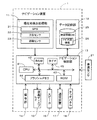
先ず、本実施例に係るナビゲーション装置の概略構成について図1に基づいて説明する。図1は本実施例に係るナビゲーション装置1を示したブロック図である。
図1に示すように、本実施例に係るナビゲーション装置1は、自車の現在位置等を検出する現在地検出処理部11と、各種のデータが記録されたデータ記録部12と、入力された情報に基づいて、各種の演算処理を行うナビゲーション制御部13と、操作者からの操作を受け付ける操作部14と、操作者に対して地図等の情報を表示する液晶ディスプレイ15と、経路案内等に関する音声ガイダンスを出力するスピーカ16と、不図示の道路交通情報センタや地図情報配信センタ等との間で携帯電話網等を介して通信を行う通信装置17と、液晶ディスプレイ15の表面に装着されたタッチパネル18とから構成されている。また、ナビゲーション制御部13には自車の走行速度を検出する車速センサ21が接続されている。
[Schematic configuration of navigation device]
First, a schematic configuration of the navigation device according to the present embodiment will be described with reference to FIG. FIG. 1 is a block diagram showing a
As shown in FIG. 1, the
以下に、ナビゲーション装置1を構成する各構成要素について説明すると、現在地検出処理部11は、GPS31、方位センサ32、距離センサ33等からなり、自車両の現在位置(以下、「自車位置」という。)、自車の向きを表す自車方位、走行距離等を検出することが可能となっている。
Hereinafter, each component constituting the
また、データ記録部12は、外部記憶装置及び記録媒体としてのハードディスク(図示せず)と、ハードディスクに記憶された地図情報データベース(地図情報DB)25及び所定のプログラム等を読み出すとともにハードディスクに所定のデータを書き込む為のドライバ(図示せず)とを備えている。
The
また、地図情報DB25には、ナビゲーション装置1の走行案内や経路探索に使用されるナビ地図情報26が格納されている。ここで、ナビ地図情報26には、経路案内及び地図表示に必要な各種情報から構成されており、例えば、各新設道路を特定するための新設道路情報、地図を表示するための地図表示データ、各交差点に関する交差点データ、ノード点に関するノードデータ、道路(リンク)に関するリンクデータ、経路を探索するための探索データ、施設の一種である店舗等のPOI(Point of Interest)に関する店舗データ、地点を検索するための検索データ等から構成されている。
The
また、店舗データとしては、各地域のホテル、遊園地、宮殿、病院、ガソリンスタンド、駐車場、駅、空港、フェリー乗り場等のPOIに関する名称や住所、電話番号、地図上の座標位置(例えば、緯度と経度である。)、地図上に施設の位置を表示する施設アイコン等のデータがPOIを特定するIDとともに記憶されている。
また、地図情報DB25の内容は、不図示の地図情報配信センタから通信装置17を介して配信された更新情報をダウンロードすることによって更新される。
In addition, as store data, names, addresses, telephone numbers, and coordinate positions on the map (for example, POIs such as hotels, amusement parks, palaces, hospitals, gas stations, parking lots, stations, airports, and ferry platforms in each region) Latitude and longitude.), Data such as a facility icon for displaying the location of the facility on the map is stored together with an ID for identifying the POI.
The contents of the
また、図1に示すように、ナビゲーション装置1を構成するナビゲーション制御部13は、ナビゲーション装置1の全体の制御を行う演算装置及び制御装置としてのCPU41、並びにCPU41が各種の演算処理を行うに当たってワーキングメモリとして使用されるとともに、経路が探索されたときの経路データ等が記憶されるRAM42、制御用のプログラム等が記憶されたROM43、ROM43から読み出したプログラムを記憶するフラッシュメモリ44等の内部記憶装置や、時間を計測するタイマ45等を備えている。
As shown in FIG. 1, the
また、ROM43には、後述のユーザが液晶ディスプレイ15の表示画面上を指で押下してドラッグ操作した場合に、この指を動かした方向へ地図画像をスクロールさせる「スクロール処理」(図2参照)等のプログラムが記憶されている。
更に、前記ナビゲーション制御部13には、操作部14、液晶ディスプレイ15、スピーカ16、通信装置17、タッチパネル18の各周辺装置(アクチュエータ)が電気的に接続されている。
The
Furthermore, the
この操作部14は、走行開始時の現在位置を修正し、案内開始地点としての出発地及び案内終了地点としての目的地を入力する際や施設に関する情報の検索を行う場合等に操作され、各種のキーや複数の操作スイッチから構成される。そして、ナビゲーション制御部13は、各スイッチの押下等により出力されるスイッチ信号に基づき、対応する各種の動作を実行すべく制御を行う。
This
また、液晶ディスプレイ15には、現在走行中の地図情報、目的地周辺の地図情報、操作案内、操作メニュー、キーの案内、現在地から目的地までの推奨経路、推奨経路に沿った案内情報、交通情報、ニュース、天気予報、時刻、メール、テレビ番組等が表示される。
Further, the
また、スピーカ16は、ナビゲーション制御部13からの指示に基づいて、推奨経路に沿った走行を案内する音声ガイダンス等を出力する。ここで、案内される音声ガイダンスとしては、例えば、「200m先、○○交差点を右方向です。」等がある。
In addition, the
また、通信装置17は、不図示の地図情報配信センタと通信を行う携帯電話網等による通信手段であり、地図情報配信センタとの間で最もバージョンの新しい更新地図情報等の送受信を行う。また、通信装置17は地図情報配信センタに加えて、道路交通情報センタ等から送信された渋滞情報やサービスエリアの混雑状況等の各情報から成る交通情報を受信する。
The
また、タッチパネル18は、液晶ディスプレイ15の表示画面上に装着された透明なパネル状のタッチスイッチであり、液晶ディスプレイ15の画面に表示されたボタンや地図上を押下することによって各種指示コマンドの入力や、表示画面上を指で押下してドラッグ操作した場合に、この指の移動方向の検出等をすることが可能に構成されている。尚、タッチパネル18は、液晶ディスプレイ15の画面を直接押下する光センサ液晶方式等で構成してもよい。
The
[スクロール処理]
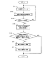
次に、上記のように構成されたナビゲーション装置1のCPU41が実行する処理であって、ユーザが液晶ディスプレイ15の表示画面上を指で押下してドラッグ操作した場合に、この指を動かした方向へ地図画像をスクロールさせる「スクロール処理」について図2乃至図12に基づいて説明する。尚、図2にフローチャートで示されるプログラムは、CPU41により実行される。
[Scroll processing]
Next, a process executed by the
図2に示すように、先ず、ステップ(以下、Sと略記する)11において、タッチパネル18の押下開始時の押下座標位置(以下、「タッチ座標」という。)、又は、前回のタッチ座標を取得した時刻から20ミリ秒経過毎に、各時点のタッチ座標を繰り返し取得してRAM42に時系列順に記憶する。そして、CPU41は、各タッチ座標を20ミリ秒経過毎に時系列順に読み出して、前回のタッチ座標に対応する画像の地点が、今回のタッチ座標へ移動するように画像をスクロールさせる。
As shown in FIG. 2, first, in step (hereinafter abbreviated as “S”) 11, the pressed coordinate position (hereinafter referred to as “touch coordinates”) at the start of pressing the
そして、S12において、CPU41は、後述の表示画面に一部のみ表示された施設を表す施設アイコンの有無を判別する施設判別方向、つまり、地図表示領域の周縁部の方向を決定する「施設判別方向決定処理」のサブ処理(図3参照)を実行する。尚、地図表示領域は、地図画像が表示されている表示画面内の領域であり、例えば、1つの画面内に複数のウィンドウが表示されている場合には、地図画像を表示しているウィンドウ領域である。また、2画面表示等で、各々の画面内に複数のウィンドウが表示されている場合には、地図表示領域は、各画面に表示されている複数のウィンドウのうち、地図画像を表示しているウィンドウ領域である。
In S12, the
続いて、S13において、CPU41は、地図画像のスクロールを停止させるか否か、つまり、タッチパネル18の押下の解除(以下、「タッチオフ」という。)が確定したか否かを判定する判定処理を実行する。そして、タッチオフが確定していないと判定した場合には(S13:NO)、CPU41は、再度S11以降の処理を実行する。尚、CPU41は、タッチオフが所定時間(例えば、約100ミリ秒である。)継続した場合に、タッチオフを確定する。
Subsequently, in S13, the
一方、タッチオフが確定したと判定した場合には(S13:YES)、CPU41は、S14の処理に移行する。S14において、CPU41は、スクロールしている地図画像を停止表示する。
その後、S15において、CPU41は、上記S12で決定した施設判別方向の地図表示領域周縁部に一部のみ表示された施設アイコンがあるか否か、つまり、施設があるか否かを判定する判定処理を実行する。
On the other hand, if it is determined that the touch-off has been confirmed (S13: YES), the
Thereafter, in S15, the
例えば、施設判別方向が「上方向」の場合には、CPU41は、表示した地図画像の上端縁部、つまり、地図表示領域の上辺部において、一部のみ表示された施設アイコンがあるか否かを判定する。また、施設判別方向が「下方向」の場合には、CPU41は、表示した地図画像の下端縁部、つまり、地図表示領域の底辺部において、一部のみ表示された施設アイコンがあるか否かを判定する。
For example, when the facility determination direction is “upward”, the
また、施設判別方向が「左方向」の場合には、CPU41は、表示した地図画像の左端縁部、つまり、地図表示領域の左辺部において、一部のみ表示された施設アイコンがあるか否かを判定する。更に、施設判別方向が「右方向」の場合には、CPU41は、表示した地図画像の右端縁部、つまり、地図表示領域の右辺部において、一部のみ表示された施設アイコンがあるか否かを判定する。
When the facility determination direction is “left direction”, the
そして、施設判別方向の地図表示領域周縁部に一部のみ表示された施設アイコンは無いと判定した場合には(S15:NO)、CPU41は、当該処理を終了する。
一方、施設判別方向の地図表示領域周縁部に一部のみ表示された施設アイコンがあると判定した場合には(S15:YES)、CPU41は、S16の処理に移行する。
If it is determined that there is no facility icon that is only partially displayed in the periphery of the map display area in the facility determination direction (S15: NO), the
On the other hand, if it is determined that there is a facility icon that is only partially displayed at the periphery of the map display area in the facility determination direction (S15: YES), the
S16において、CPU41は、後述の施設判別方向の地図表示領域周縁部に一部のみ表示された施設アイコンによって示される施設を表示施設として決定する「表示施設決定処理」のサブ処理(図4参照)を実行する。
続いて、S17において、CPU41は、後述の上記S16で決定された表示施設を表示するように地図画像を調整する「地図画像調整処理」のサブ処理(図5参照)を実行後、当該処理を終了する。
In S <b> 16, the
Subsequently, in S17, the
[施設判別方向決定処理]
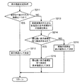
次に、上記S12で、CPU41が実行する「施設判別方向決定処理」のサブ処理について図3及び図6に基づいて説明する。
図3に示すように、先ず、S111において、CPU41は、上記S11でRAM42に記憶したタッチオフ時のタッチ座標と、押下がなくなる1つ前のタッチ座標とから、地図表示領域上での押下座標位置の移動方向を算出し、この押下座標位置の移動方向に対して反対方向を地図画像のスクロール方向としてRAM42に記憶する。
[Facility determination direction determination processing]
Next, the sub-process of the “facility determination direction determination process” executed by the
As shown in FIG. 3, first, in S111, the
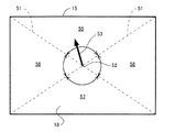
そして、図6に示すように、CPU41は、液晶ディスプレイ15の地図表示領域の一対の対角線51の交点を地図表示領域の中心52とし、この中心52から地図画像のスクロール方向に単位ベクトル53を引く。また、CPU41は、地図表示領域を一対の対角線51によって、地図表示領域の中心を共通の頂点とする4つの略三角形状に区画する。そして、CPU41は、地図表示領域の上端縁部を外側周縁部とする区画を上方向決定範囲55として設定する。
Then, as shown in FIG. 6, the
また、CPU41は、地図表示領域の左端縁部を外側周縁部とする区画を左方向決定範囲56として設定する。また、CPU41は、地図表示領域の下端縁部を外側周縁部とする区画を下方向決定範囲57として設定する。更に、CPU41は、地図表示領域の右端縁部を外側周縁部とする区画を右方向決定範囲58として設定する。
Further, the
続いて、S112において、CPU41は、スクロール方向が上方向決定範囲55に属しているか否か、つまり、地図表示領域の中心52から引いた単位ベクトル53が上方向決定範囲55に属しているか否かを判定する判定処理を実行する。そして、地図表示領域の中心52から引いた単位ベクトル53が上方向決定範囲55に属していると判定した場合には(S112:YES)、CPU41は、S113の処理に移行する。尚、単位ベクトル53が対角線51上にある場合には、単位ベクトル53は上方向決定範囲55に属していると判定する。
Subsequently, in S112, the
S113において、CPU41は、上記S15で一部のみ表示された施設アイコンがあるか否か、つまり、施設があるか否かを判定する地図表示領域の周縁部を特定するための施設判別方向を「上方向」に決定して、RAM42に記憶後、当該サブ処理を終了してメインフローチャートに戻り、S13の処理に移行する。
In S113, the
一方、地図表示領域の中心52から引いた単位ベクトル53が上方向決定範囲55に属していないと判定した場合には(S112:NO)、CPU41は、S114の処理に移行する。S114において、CPU41は、スクロール方向が下方向決定範囲57に属しているか否か、つまり、地図表示領域の中心52から引いた単位ベクトル53が下方向決定範囲57に属しているか否かを判定する判定処理を実行する。
On the other hand, when it is determined that the
そして、地図表示領域の中心52から引いた単位ベクトル53が下方向決定範囲57に属していると判定した場合には(S114:YES)、CPU41は、S115の処理に移行する。尚、単位ベクトル53が対角線51上にある場合には、単位ベクトル53は下方向決定範囲57に属していると判定する。
When it is determined that the
S115において、CPU41は、上記S15で一部のみ表示された施設アイコンがあるか否か、つまり、施設があるか否かを判定する地図表示領域の周縁部を特定するための施設判別方向を「下方向」に決定して、RAM42に記憶後、当該サブ処理を終了してメインフローチャートに戻り、S13の処理に移行する。
In S115, the
一方、地図表示領域の中心52から引いた単位ベクトル53が下方向決定範囲57に属していないと判定した場合には(S114:NO)、CPU41は、S116の処理に移行する。S116において、CPU41は、スクロール方向が左方向決定範囲56に属しているか否か、つまり、地図表示領域の中心52から引いた単位ベクトル53が左方向決定範囲56に属しているか否かを判定する判定処理を実行する。そして、地図表示領域の中心52から引いた単位ベクトル53が左方向決定範囲56に属していると判定した場合には(S116:YES)、CPU41は、S117の処理に移行する。
On the other hand, if it is determined that the
S117において、CPU41は、上記S15で一部のみ表示された施設アイコンがあるか否か、つまり、施設があるか否かを判定する地図表示領域の周縁部を特定するための施設判別方向を「左方向」に決定して、RAM42に記憶後、当該サブ処理を終了してメインフローチャートに戻り、S13の処理に移行する。
In S117, the
一方、地図表示領域の中心52から引いた単位ベクトル53が左方向決定範囲56に属していないと判定した場合には(S116:NO)、CPU41は、S118の処理に移行する。S118において、CPU41は、上記S15で一部のみ表示された施設アイコンがあるか否か、つまり、施設があるか否かを判定する地図表示領域の周縁部を特定するための施設判別方向を「右方向」に決定して、RAM42に記憶後、当該サブ処理を終了してメインフローチャートに戻り、S13の処理に移行する。
On the other hand, if it is determined that the
[表示施設決定処理]
次に、上記S16で、CPU41が実行する「表示施設決定処理」のサブ処理について図4及び図7に基づいて説明する。
図4に示すように、先ず、S211において、CPU41は、上記S12で決定された施設判別方向の地図表示領域周縁部に、つまり、施設判別方向の地図表示領域の端縁部に、一部のみ表示された施設アイコンによって示される施設は1つか否かを判定する判定処理を実行する。
[Display facility decision processing]
Next, the sub-process of “display facility determination process” executed by the
As shown in FIG. 4, first, in S211, the
そして、施設判別方向の地図表示領域周縁部に、つまり、施設判別方向の地図表示領域の端縁部に、一部のみ表示された施設アイコンによって示される施設は1つであると判定した場合には(S211:YES)、CPU41は、S212の処理に移行する。S212において、CPU41は、この一部のみ表示された施設アイコンによって示される施設を「表示施設」として決定して、RAM42に記憶後、当該サブ処理を終了してメインフローチャートに戻り、S17の処理に移行する。
When it is determined that there is only one facility indicated by the facility icon displayed only partially at the edge of the map display area in the facility determination direction, that is, at the edge of the map display area in the facility determination direction. (S211: YES), the
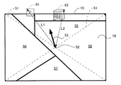
一方、施設判別方向の地図表示領域周縁部に、一部のみ表示された施設アイコンによって示される施設が複数個あると判定した場合には(S211:NO)、CPU41は、S213の処理に移行する。S213において、CPU41は、地図画像の中心から、つまり、地図表示領域の中心から、一部のみ表示された各施設アイコンの表示座標までの最大距離を算出する。
On the other hand, if it is determined that there are a plurality of facilities indicated by the facility icons displayed only partially in the periphery of the map display area in the facility determination direction (S211: NO), the
例えば、図7に示すように、上記S12で、施設判別方向を「上向き」に決定した場合には、CPU41は、表示した地図画像の上端縁部、つまり、地図表示領域の上辺部において、駐車場の位置を示す駐車場アイコン61と、建物の位置を示す建物アイコン62とを、一部のみ表示された施設アイコンとして選択する。そして、CPU41は、地図表示領域の中心52から駐車場アイコン61と建物アイコン62のそれぞれの表示座標までの最大距離L1、L2を算出する。
For example, as shown in FIG. 7, when the facility determination direction is determined to be “upward” in S12, the
続いて、S214において、CPU41は、表示した地図画像の中心から、つまり、地図表示領域の中心から、一部のみ表示された各施設アイコンの表示座標までの最大距離を比較し、地図表示領域の中心から最も遠い表示座標を持つ施設アイコンがあるか否かを判定する判定処理を実行する。そして、地図表示領域の中心から最も遠い表示座標を持つ施設アイコンがあると判定した場合には(S214:YES)、CPU41は、S215の処理に移行する。
Subsequently, in S214, the
S215において、CPU41は、地図表示領域の中心から最も遠い表示座標を持つ施設アイコンによって示される施設を「表示施設」として決定して、RAM42に記憶後、当該サブ処理を終了してメインフローチャートに戻り、S17の処理に移行する。
例えば、図7に示すように、地図表示領域の中心52から駐車場アイコン61の表示座標までの最大距離L1が最も大きい場合には、CPU41は、駐車場アイコン61によって示される施設を「表示施設」として決定し、RAM42に記憶する。
In S215, the
For example, as shown in FIG. 7, when the maximum distance L1 from the
一方、地図表示領域の中心から最も遠い表示座標を持つ施設アイコンが無い、つまり、地図表示領域の中心から、一部のみ表示された各施設アイコンの表示座標までの最大距離が同じものが複数あると判定した場合には(S214:NO)、CPU41は、S216の処理に移行する。S216において、CPU41は、この最大距離が同じ複数の施設アイコンによって示される各施設を「表示施設」として決定して、RAM42に記憶後、当該サブ処理を終了してメインフローチャートに戻り、S17の処理に移行する。
On the other hand, there is no facility icon having the display coordinates farthest from the center of the map display area, that is, there are a plurality of the same maximum distance from the center of the map display area to the display coordinates of each partially displayed facility icon. (S214: NO), the
[地図画像調整処理]
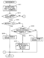
次に、上記S17で、CPU41が実行する「地図画像調整処理」のサブ処理について図5、図7乃至図12に基づいて説明する。
図5に示すように、先ず、S311において、CPU41は、上記S16で決定した「表示施設」をRAM42から読み出し、上記S12で決定した「施設判別方向」に地図画像をスクロールして、当該「表示施設」を示す施設アイコンの全体を地図表示領域内に表示するために必要なスクロール移動量を算出する。
[Map image adjustment processing]
Next, the sub-process of the “map image adjustment process” executed by the
As shown in FIG. 5, first, in S <b> 311, the
続いて、S312において、CPU41は、上記S311で算出したスクロール移動量が、所定移動量以下(例えば、地図表示領域の当該スクロール方向の幅の約1/3以下である。)か否かを判定する判定処理を実行する。そして、スクロール移動量が所定移動量よりも大きいと判定した場合には(S312:NO)、CPU41は、地図画像をスクロールさせることなく当該サブ処理を終了してメインフローチャートに戻る。
Subsequently, in S312, the
一方、スクロール移動量が所定移動量以下であると判定した場合には(S312:YES)、CPU41は、S313の処理に移行する。S313において、CPU41は、上記S16で決定した「表示施設」をRAM42から読み出し、1つか否かを判定する判定処理を実行する。そして、「表示施設」が1つであると判定した場合には(S313:YES)、CPU41は、S314の処理に移行する。
On the other hand, when it is determined that the scroll movement amount is equal to or less than the predetermined movement amount (S312: YES), the
S314において、CPU41は、上記S311で算出したスクロール移動量だけ、上記S12で決定した「施設判別方向」に地図画像をスクロールして、当該「表示施設」を示す施設アイコンの全体を地図表示領域内に表示する。つまり、「表示施設」に対応する施設アイコンの全体を表示するように、施設判別方向の地図表示領域の周縁部の中央位置に対向する地点が、地図表示領域の中心へ移動する方向に地図画像をスクロールさせた後、当該サブ処理を終了してメインフローチャートに戻る。
In S314, the
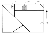
例えば、図7に示すように、地図表示領域の中心52からの最大距離L1が最も大きい駐車場アイコン61によって示される施設が「表示施設」として決定された場合には、CPU41は、地図画像を「上方向」にスクロールして、当該「表示施設」を示す駐車場アイコン61の全体を地図表示領域内に表示するために必要なスクロール移動量を算出する。そして、図8に示すように、CPU41は、このスクロール移動量だけ地図画像を「上方向」へスクロールして、駐車場アイコン61及び建物アイコン62の全体を地図表示領域内に表示する。
For example, as illustrated in FIG. 7, when the facility indicated by the
他方、上記S16で決定した「表示施設」が複数である、つまり、地図表示領域の中心から施設アイコンの表示座標までの最大距離が同じ表示施設が2個あると判定した場合には(S313:NO)、CPU41は、S315の処理に移行する。S315において、CPU41は、各「表示施設」は、上記S12で決定した「施設判別方向」の地図表示領域の端縁部の両端よりも該端縁部に沿った外側に位置するか否かを判定する判定処理を実行する。
On the other hand, when it is determined that there are a plurality of “display facilities” determined in S16, that is, there are two display facilities having the same maximum distance from the center of the map display area to the display coordinates of the facility icon (S313: NO), CPU41 transfers to the process of S315. In S315, the
そして、各「表示施設」は、上記S12で決定した「施設判別方向」の地図表示領域の端縁部の両端よりも該端縁部に沿った外側に位置すると判定した場合には(S315:YES)、CPU41は、S316の処理に移行する。S316において、CPU41は、地図表示領域の中心から、一部のみ表示された各施設アイコンの表示座標までの最大距離に基づいて、地図画像の縮尺を拡大し、各施設アイコンの全体を地図表示領域内に表示した後、当該サブ処理を終了してメインフローチャートに戻る。
When it is determined that each “display facility” is located outside the both ends of the edge portion of the map display area in the “facility determination direction” determined in S12 above (S315: YES), the
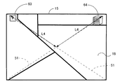
例えば、図9に示すように、上記S12で決定した施設判別方向が「上方向」で、地図表示領域の上端縁部において一部のみ表示された駐車場アイコン63と建物アイコン64が2個あり、これらが地図表示領域の上端縁部の両端よりも該端縁部に沿った外側に位置している。この場合には、図10に示すように、CPU41は、地図表示領域の中心52から、一部のみ表示された駐車場アイコン63と建物アイコン64のそれぞれの表示座標までの最大距離L3が、最大距離L4になるまで地図画像の縮尺を拡大し、駐車場アイコン63と建物アイコン64の全体を地図表示領域内に表示する。
For example, as shown in FIG. 9, the facility determination direction determined in S12 is “upward”, and there are two
一方、各「表示施設」は、上記S12で決定した「施設判別方向」の地図表示領域の端縁部の両端よりも内側に位置すると判定した場合には(S315:NO)、CPU41は、S317の処理に移行する。S317において、CPU41は、上記S311で算出したスクロール移動量だけ、上記S12で決定した「施設判別方向」に地図画像をスクロールして、各施設アイコンの全体を地図表示領域内に表示した後、当該サブ処理を終了してメインフローチャートに戻る。
On the other hand, if it is determined that each “display facility” is positioned inside both ends of the edge of the map display area in the “facility determination direction” determined in S12 (S315: NO), the
例えば、図11に示すように、上記S12で決定した施設判別方向が「上方向」で、地図表示領域の上端縁部において一部のみ表示された駐車場アイコン65と建物アイコン66が2個あり、これらが地図表示領域の上端縁部の両端よりも内側に位置している。この場合には、CPU41は、駐車場アイコン65と建物アイコン66の全体を地図表示領域内に表示するために必要なスクロール移動量を算出する。そして、図12に示すように、CPU41は、このスクロール移動量だけ地図画像を「上方向」へスクロールして、駐車場アイコン65及び建物アイコン66の全体を地図表示領域内に表示する
For example, as shown in FIG. 11, the facility determination direction determined in S12 is “upward”, and there are two
以上詳細に説明した通り、本実施例に係るナビゲーション装置1では、CPU41は、地図表示領域の中心52からスクロール方向に単位ベクトル53を引く。そして、CPU41は、地図表示領域の中心52から、この単位ベクトル53が含まれる各方向決定範囲55〜58の周縁部の中央位置に向かう方向を施設判別方向として決定することにより、ユーザの希望するスクロール方向の施設、つまり、ユーザの確認したい施設を確実に表示することができる。
As described in detail above, in the
また、CPU41は、施設判別方向の地図表示領域周縁部に一部のみ表示された施設アイコンが1つある場合には、当該施設アイコンによって示される施設を「表示施設」として決定し、一部のみ表示された施設アイコンが2つ以上ある場合には、地図表示領域の中心から最も遠い表示座標を持つ施設アイコンによって示される施設を「表示施設」として決定する。また、地図表示領域の中心から最も遠い表示座標までの距離が等しい施設アイコンが2個ある場合には、この2個の施設アイコンによって示される各施設を「表示施設」として決定する。
In addition, when there is one facility icon that is partially displayed at the periphery of the map display area in the facility determination direction, the
そして、「表示施設」に対応する施設アイコンの全体を表示するように、施設判別方向の地図表示領域の周縁部の中央位置が、地図表示領域の中心へ移動する方向に地図画像をスクロールさせる。また、地図画像をスクロールさせて「表示施設」に対応する施設アイコンの全体を表示することができない場合でも、地図画像の縮尺を拡大して、確実に表示施設の全体を表示することができる。 Then, the map image is scrolled in such a direction that the center position of the peripheral portion of the map display area in the facility determination direction moves to the center of the map display area so as to display the entire facility icon corresponding to the “display facility”. Further, even when the map image cannot be scrolled to display the entire facility icon corresponding to “display facility”, the scale of the map image can be enlarged to reliably display the entire display facility.
これにより、スクロール終了時にスクロール方向の地図表示領域周縁部に位置する各施設アイコンの全体を確実に表示することができる。従って、ユーザは一度のスクロール操作により、スクロール方向の地図表示領域周縁部に表示された複数個の施設を表示画面に表示することができる。 Thereby, the whole each facility icon located in the map display area peripheral part of a scroll direction can be reliably displayed at the time of a scroll end. Therefore, the user can display a plurality of facilities displayed on the periphery of the map display area in the scroll direction on the display screen by one scroll operation.
また、スクロール終了時にスクロール方向の地図表示領域周縁部に位置する各施設アイコンの全体を確実に表示するために必要なスクロール移動量が所定移動量より大きい場合には、当該各施設アイコンを一部のみ表示した状態でスクロールを停止させる。これにより、一部のみ表示された施設の面積が、国立公園や大規模遊園地等のように広く、追加してスクロールすることによって地図表示領域の中心部が移動しすぎる場合には、ユーザに違和感を与えることなく、これらの施設の全体を表示することを防止することができる。 In addition, when the scroll movement amount necessary for reliably displaying the entire facility icons located at the periphery of the map display area in the scroll direction at the end of scrolling is larger than the predetermined movement amount, a part of each facility icon is included. Stop scrolling with only the display. As a result, if the area of the facility that is only partially displayed is large, such as a national park or a large-scale amusement park, and the center of the map display area moves too much by scrolling additionally, the It is possible to prevent the entire facility from being displayed without giving a sense of incongruity.
尚、本発明は前記実施例に限定されるものではなく、本発明の要旨を逸脱しない範囲内で種々の改良、変形が可能であることは勿論である。例えば、以下のようにしてもよい。 In addition, this invention is not limited to the said Example, Of course, various improvement and deformation | transformation are possible within the range which does not deviate from the summary of this invention. For example, the following may be used.
(A)例えば、タッチオフが確定したと判定した場合には(S13:YES)、CPU41は、上記S14の処理を実行することなく、S15の処理に移行するようにしてもよい。これにより、地図画像を一旦停止させることなく、地図表示領域周縁部に位置する施設アイコンの全体を表示するようにスムーズにスクロール表示させることが可能となる。
(A) For example, when it is determined that the touch-off has been confirmed (S13: YES), the
(B)また、上記S15で、施設判別方向の地図表示領域周縁部に一部のみ表示された施設アイコンがあると判定した場合には(S15:YES)、CPU41は、施設判別方向以外の地図表示領域周縁部にも一部のみ表示された施設アイコンがあるか否かを判定する判定処理を実行するようにしてもよい。そして、施設判別方向以外の地図表示領域周縁部にも一部のみ表示された施設アイコンがあると判定した場合には、CPU41は、当該処理を終了するようにしてもよい。一方、施設判別方向以外の地図表示領域周縁部には、一部のみ表示された施設アイコンが無いと判定した場合に、CPU41は、S16以降の処理を実行するようにしてもよい。
(B) If it is determined in S15 that there is a facility icon that is only partially displayed in the periphery of the map display area in the facility determination direction (S15: YES), the
これにより、施設判別方向以外の方向の地図表示領域の周縁部に一部のみ表示された施設アイコンが無い場合のみ、地図画像をスクロールさせ、又は、地図画像の縮尺を拡大するため、地図画像のスクロールや縮尺の拡大によって地図表示領域から消される施設を無くすことができる。 Thereby, in order to scroll the map image or to enlarge the scale of the map image only when there is no facility icon only partially displayed in the peripheral part of the map display area in the direction other than the facility determination direction, Facilities that are erased from the map display area by scrolling or scaling up can be eliminated.
1 ナビゲーション装置
14 操作部
15 液晶ディスプレイ
18 タッチパネル
25 地図情報DB
26 ナビ地図情報
41 CPU
42 RAM
43 ROM
51 対角線
52 中心
53 単位ベクトル
55 上方向決定範囲
56 左方向決定範囲
57 下方向決定範囲
58 右方向決定範囲
61、63、65 駐車場アイコン
62、64、66 建物アイコン
DESCRIPTION OF
26
42 RAM
43 ROM
51
Claims (8)
前記地図情報に基づいて前記施設を含む地図画像を表示する表示手段と、
前記地図画像のスクロール方向を入力する入力手段と、
前記入力手段を介して入力された前記地図画像のスクロール方向を検出するスクロール方向検出手段と、
前記地図画像のスクロールが停止したときに表示画面に一部のみ表示される施設の有無を判別する施設判別方向を、前記スクロール方向に基づいて決定する施設判別方向決定手段と、
前記一部のみ表示される施設が、前記施設判別方向決定手段によって決定された施設判別方向にあるか否かを判定する施設判定手段と、
前記施設判定手段を介して前記一部のみ表示される施設が、前記施設判別方向決定手段によって決定された施設判別方向にあると判定された場合には、当該施設の全体が表示されるように前記地図画像を調整する地図画像調整手段と、
を備えたことを特徴とする情報表示装置。 Map information storage means for storing map information including facility information about the facility;
Display means for displaying a map image including the facility based on the map information;
Input means for inputting a scroll direction of the map image;
Scroll direction detecting means for detecting a scroll direction of the map image input via the input means;
A facility determination direction determining means for determining a facility determination direction for determining whether or not there is a facility that is only partially displayed on the display screen when scrolling of the map image is stopped; and
Facility determination means for determining whether the part of the displayed facility is in the facility determination direction determined by the facility determination direction determination means;
When it is determined that the facility that is only partially displayed through the facility determination unit is in the facility determination direction determined by the facility determination direction determination unit, the entire facility is displayed. Map image adjusting means for adjusting the map image;
An information display device comprising:
前記表示施設決定手段は、前記地図画像のスクロールが停止したときに、前記施設判別方向の表示画面に一部のみ表示される施設の個数が複数の場合は、各施設の前記表示画面の中心位置から最も遠い表示座標の距離に基づいて前記表示施設を決定することを特徴とする請求項1又は請求項2に記載の情報表示装置。 When it is determined that the facility that is only partially displayed via the facility determination means is in the facility determination direction determined by the facility determination direction determination means, the entire facility among the determined facilities Display facility determining means for determining a display facility for displaying
When the scroll of the map image is stopped, the display facility determining means, when there are a plurality of facilities displayed only partially on the display screen in the facility determination direction, the center position of the display screen of each facility The information display device according to claim 1, wherein the display facility is determined based on a distance of a display coordinate farthest from the display.
前記表示施設決定手段によって決定された表示施設の全体を表示するために必要な地図画像のスクロール移動量を取得する移動量取得手段と、
前記スクロール移動量が所定移動量以下か否かを判定する移動量判定手段と、
を有し、
該地図画像調整手段は、前記前記スクロール移動量が所定移動量以下であると判定した場合に、前記表示施設決定手段によって決定された表示施設の全体が表示されるように前記地図画像を調整することを特徴とする請求項3に記載の情報表示装置。 The map image adjusting means includes
A movement amount acquisition means for acquiring a scroll movement amount of a map image necessary for displaying the entire display facility determined by the display facility determination means;
A movement amount determination means for determining whether or not the scroll movement amount is equal to or less than a predetermined movement amount;
Have
The map image adjusting unit adjusts the map image so that the entire display facility determined by the display facility determining unit is displayed when it is determined that the scroll movement amount is equal to or less than a predetermined movement amount. The information display device according to claim 3.
該地図画像調整手段は、
前記表示判定手段を介して前記表示施設の全体を表示することができると判定した場合には、前記地図上の前記判別方向の表示画面の中央位置が表示画面の中心へ移動する方向に前記地図画像をスクロールさせて前記表示施設の全体を表示し、
前記表示判定手段を介して前記表示施設の全体を表示することができないと判定した場合には、前記地図画像の縮尺を拡大することを特徴とする請求項3又は請求項4に記載の情報表示装置。 Whether the map image adjusting means can display the entire display facility by scrolling the map image in a direction in which the center position of the display screen of the facility determination direction on the map moves to the center of the display screen. Display determination means for determining whether or not,
The map image adjusting means includes:
When it is determined that the entire display facility can be displayed via the display determination unit, the map is moved in the direction in which the center position of the display screen in the determination direction on the map moves to the center of the display screen. Scroll the image to display the entire display facility,
The information display according to claim 3 or 4, wherein when it is determined that the entire display facility cannot be displayed via the display determination means, the scale of the map image is enlarged. apparatus.
前記地図画像調整手段は、前記施設判別方向外施設判定手段によって前記施設判別方向以外の方向の表示画面に一部のみ表示される施設が無いと判定された場合に、前記施設判別方向にある一部のみ表示される施設の全体が表示されるように地図画像を調整することを特徴とする請求項1乃至請求項5のいずれかに記載の情報表示装置。 When it is determined that the facility that is only partially displayed via the facility determination unit is in the facility determination direction determined by the facility determination direction determination unit, a display screen in a direction other than the facility determination direction In addition, there is a facility determination means outside the facility determination direction that determines whether there is a facility that is only partially displayed,
The map image adjustment means is located in the facility determination direction when the facility determination means outside the facility determination direction determines that there is no facility that is partially displayed on the display screen in a direction other than the facility determination direction. The information display device according to any one of claims 1 to 5, wherein the map image is adjusted so that an entire facility that is displayed only in a part is displayed.
地図画像のスクロール方向を入力する入力手段を介して入力された前記地図画像のスクロール方向を検出するスクロール方向検出工程と、
前記地図画像のスクロールが停止したときに一部のみ表示される施設の有無を判別する施設判別方向を、前記スクロール方向に基づいて決定する施設判別方向決定工程と、
前記一部のみ表示される施設が、前記施設判別方向決定工程で決定された施設判別方向にあるか否かを判定する施設判定工程と、
前記施設判定工程で前記一部のみ表示される施設が、前記施設判別方向決定工程で決定された施設判別方向にあると判定された場合には、当該施設の全体が表示されるように前記地図画像を調整する地図画像調整工程と、
を備えたことを特徴とする情報表示方法。 A display step of displaying a map image including the facility based on map information including facility information regarding the facility;
A scroll direction detecting step of detecting a scroll direction of the map image input via an input means for inputting a scroll direction of the map image;
A facility determination direction determining step for determining a facility determination direction for determining presence or absence of a facility that is only partially displayed when scrolling of the map image is stopped; and
A facility determination step for determining whether the part of the displayed facility is in the facility determination direction determined in the facility determination direction determination step;
When it is determined that the facility that is only partially displayed in the facility determination step is in the facility determination direction determined in the facility determination direction determination step, the map is displayed so that the entire facility is displayed. A map image adjustment process for adjusting the image;
An information display method characterized by comprising:
施設に関する施設情報を含む地図情報に基づいて前記施設を含む地図画像を表示する表示工程と、
地図画像のスクロール方向を入力する入力手段を介して入力された前記地図画像のスクロール方向を検出するスクロール方向検出工程と、
前記地図画像のスクロールが停止したときに一部のみ表示される施設の有無を判別する施設判別方向を、前記スクロール方向に基づいて決定する施設判別方向決定工程と、
前記一部のみ表示される施設が、前記施設判別方向決定工程で決定された施設判別方向にあるか否かを判定する施設判定工程と、
前記施設判定工程で前記一部のみ表示される施設が、前記施設判別方向決定工程で決定された施設判別方向にあると判定された場合には、当該施設の全体が表示されるように前記地図画像を調整する地図画像調整工程と、
を実行させるためのプログラム。 On the computer,
A display step of displaying a map image including the facility based on map information including facility information regarding the facility;
A scroll direction detecting step of detecting a scroll direction of the map image input via an input means for inputting a scroll direction of the map image;
A facility determination direction determining step for determining a facility determination direction for determining presence or absence of a facility that is only partially displayed when scrolling of the map image is stopped; and
A facility determination step for determining whether the part of the displayed facility is in the facility determination direction determined in the facility determination direction determination step;
When it is determined that the facility that is only partially displayed in the facility determination step is in the facility determination direction determined in the facility determination direction determination step, the map is displayed so that the entire facility is displayed. A map image adjustment process for adjusting the image;
A program for running
Priority Applications (1)
| Application Number | Priority Date | Filing Date | Title |
|---|---|---|---|
| JP2010278360A JP2012128100A (en) | 2010-12-14 | 2010-12-14 | Information display device, information display method, and program |
Applications Claiming Priority (1)
| Application Number | Priority Date | Filing Date | Title |
|---|---|---|---|
| JP2010278360A JP2012128100A (en) | 2010-12-14 | 2010-12-14 | Information display device, information display method, and program |
Publications (1)
| Publication Number | Publication Date |
|---|---|
| JP2012128100A true JP2012128100A (en) | 2012-07-05 |
Family
ID=46645219
Family Applications (1)
| Application Number | Title | Priority Date | Filing Date |
|---|---|---|---|
| JP2010278360A Pending JP2012128100A (en) | 2010-12-14 | 2010-12-14 | Information display device, information display method, and program |
Country Status (1)
| Country | Link |
|---|---|
| JP (1) | JP2012128100A (en) |
Cited By (1)
| Publication number | Priority date | Publication date | Assignee | Title |
|---|---|---|---|---|
| JP2015125645A (en) * | 2013-12-26 | 2015-07-06 | 克仁 岩波 | Information processing apparatus |
-
2010
- 2010-12-14 JP JP2010278360A patent/JP2012128100A/en active Pending
Cited By (1)
| Publication number | Priority date | Publication date | Assignee | Title |
|---|---|---|---|---|
| JP2015125645A (en) * | 2013-12-26 | 2015-07-06 | 克仁 岩波 | Information processing apparatus |
Similar Documents
| Publication | Publication Date | Title |
|---|---|---|
| JP5381691B2 (en) | Map display device, map display method and program | |
| JP5533254B2 (en) | Information display device, information display method, and program | |
| US7869938B2 (en) | Method and apparatus for displaying simplified map image for navigation system | |
| JP5347988B2 (en) | Navigation device | |
| EP2366973A2 (en) | Map display apparatus, map display method and program | |
| JP4736996B2 (en) | Map display control device and map display control program | |
| JP4145028B2 (en) | POI icon display method and navigation device | |
| JP5766076B2 (en) | Map display device using direction distance mark | |
| US20110175928A1 (en) | Map Display Device and Map Display Method | |
| JP5333321B2 (en) | Navigation device | |
| US8520029B2 (en) | Image display device, image display method, and program | |
| JP2011059952A (en) | Input/output display device | |
| JP2008180786A (en) | Navigation system and navigation device | |
| JP5328280B2 (en) | Navigation device | |
| EP2461133A1 (en) | Map display device | |
| JP2009014486A (en) | Navigation device, and guiding method and program | |
| JP2013050305A (en) | Map display device and program | |
| JP2012133245A (en) | Map display device, map display method, and computer program | |
| JP2011070554A (en) | Input and output display device | |
| EP1901038A1 (en) | Map display system and navigation system | |
| JP2010236910A (en) | Navigation system | |
| JP2009098086A (en) | Navigation device and scroll method | |
| JP2012128100A (en) | Information display device, information display method, and program | |
| JP4824611B2 (en) | Navigation device with touch panel | |
| JP4835494B2 (en) | Map display device |