JP2009014486A - Navigation device, and guiding method and program - Google Patents
Navigation device, and guiding method and program Download PDFInfo
- Publication number
- JP2009014486A JP2009014486A JP2007176233A JP2007176233A JP2009014486A JP 2009014486 A JP2009014486 A JP 2009014486A JP 2007176233 A JP2007176233 A JP 2007176233A JP 2007176233 A JP2007176233 A JP 2007176233A JP 2009014486 A JP2009014486 A JP 2009014486A
- Authority
- JP
- Japan
- Prior art keywords
- facility
- road
- map
- attribute
- displayed
- Prior art date
- Legal status (The legal status is an assumption and is not a legal conclusion. Google has not performed a legal analysis and makes no representation as to the accuracy of the status listed.)
- Pending
Links
Images


Abstract
Description
本発明は、ナビゲーション装置、その案内方法及び案内プログラムに関する。 The present invention relates to a navigation apparatus, a guidance method thereof, and a guidance program.
従来より、ナビゲーションシステムは、自車位置周辺のガソリンスタンド、コンビニエンスストア等の施設の位置を、地図画面上に表示されたアイコンによって案内している。このアイコンは、アイコン自身に描画された図柄や文字等によって、例えば「ガソリンスタンド」といった、案内対象となる施設のカテゴリを案内する。運転者は、地図画面に表示されたアイコンによって、自車位置周辺にある施設のカテゴリと施設の位置を得ることができる。 Conventionally, the navigation system guides the positions of facilities such as gas stations and convenience stores around the position of the vehicle by icons displayed on the map screen. This icon guides the category of the facility to be guided, for example, “gas station”, by the pattern or character drawn on the icon itself. The driver can obtain the category of the facility and the position of the facility around the position of the vehicle by using the icons displayed on the map screen.
しかし、地域や地図縮尺によっては、各施設を示すアイコンが重なることがある。例えば、図11に示す地図画面100のように、施設が局所的に密集すると、アイコン101の重なりが生じ、各アイコン101が表すカテゴリを見分けることが困難になる。
However, depending on the area and map scale, icons indicating each facility may overlap. For example, if facilities are locally concentrated like the
これに対し、特許文献1には、アイコンが重なった際に、該アイコンを間引くナビゲーションシステムが記載されている。このシステムでは、施設のカテゴリに表示優先度を設定し、該表示優先度が低い施設のアイコンを間引いて、全体として各アイコンを見やすく表示する。
しかし、上記したシステムでは、表示優先度がユーザの要望に沿わない場合がある。例えば、運転者が自車位置周辺にある「レストラン」の位置を確認したいにも関わらず、「レストラン」のアイコンを間引いて他の施設のアイコンを表示すると、ユーザにとって必要な情報が非表示になってしまう。 However, in the above-described system, the display priority may not meet the user's request. For example, if the driver wants to check the location of a “restaurant” near the location of the vehicle, but displays the icon of another facility by thinning the “restaurant” icon, the information necessary for the user is hidden. turn into.
本発明は、上記問題点に鑑みてなされたものであり、その目的は、ユーザにとって必要性の高い施設指標を視認しやすい状態で地図上に表示することができるナビゲーション装置、その案内方法及び案内プログラムを提供することにある。 The present invention has been made in view of the above problems, and a purpose of the present invention is to provide a navigation device that can display facility indicators that are highly necessary for a user on a map in a state where the facility indicators are easily visible, a guidance method thereof, and guidance To provide a program.
上記問題点を解決するために、請求項1に記載の発明は、地図データを記憶した地図データ記憶手段と、道路の属性情報を記憶した道路属性記憶手段と、施設情報を記憶した施設情報記憶手段とを用い、施設の位置を示す施設指標を前記地図データに基づく地図上に表示するナビゲーション装置において、地図への表示対象の施設を前記施設情報記憶手段から抽出する抽出手段と、前記属性情報に基づき、施設に隣接する道路の属性を取得する道路属性取得手段と、施設に隣接する道路の属性に基づき、該施設の位置を示す前記施設指標の表示の可否を判断する表示判断手段と、前記表示判断手段により非表示とすると判断された前記施設指標を間引き、表示する前記施設指標を前記地図データに基づく地図上に表示する出力制御手段とを備えたことを要旨とする。
In order to solve the above problem, the invention described in
請求項2に記載の発明は、請求項1に記載のナビゲーション装置において、前記表示判断手段は、前記地図において非表示とされる道路の属性を取得し、表示対象の施設のうち、該非表示とされる属性の道路に隣接する前記施設の前記施設指標を非表示とすることを要旨とする。 According to a second aspect of the present invention, in the navigation device according to the first aspect, the display determination unit acquires an attribute of a road that is hidden in the map, and the non-display is selected among the facilities to be displayed. The gist is to hide the facility index of the facility adjacent to the road with the attribute to be displayed.
請求項3に記載の発明は、請求項1に記載のナビゲーション装置において、前記表示判断手段は、表示対象の前記施設に隣接する道路の属性を取得し、該道路属性が、所定の道路種別よりも下位のレベルである前記施設の前記施設指標を非表示とすることを要旨とする。 According to a third aspect of the present invention, in the navigation device according to the first aspect, the display determining unit acquires an attribute of a road adjacent to the facility to be displayed, and the road attribute is determined from a predetermined road type. The gist is to hide the facility index of the facility at the lower level.
請求項4に記載の発明は、請求項1に記載のナビゲーション装置において、前記表示判断手段は、表示対象の前記施設のうち、前記施設に隣接する道路が、自車両が現在走行している道路以外である場合に、前記施設の該施設指標を非表示とすることを要旨とする。 According to a fourth aspect of the present invention, in the navigation device according to the first aspect, the display determination unit is configured such that, among the facilities to be displayed, a road adjacent to the facility is a road on which the vehicle is currently traveling. If it is other than the above, the gist is to hide the facility index of the facility.
請求項5に記載の発明は、請求項1〜4のいずれか1項に記載のナビゲーション装置において、前記表示判断手段は、表示対象である前記施設の前記施設指標に重なりがあるか否かを判断し、重なりがあると判断した前記施設指標に対し、前記施設に隣接する道路の属性に基づき、前記施設指標の表示の可否を判断することを要旨とする。
The invention according to
請求項6に記載の発明は、地図データを記憶した地図データ記憶手段と、施設情報を記憶した施設情報記憶手段とを用い、施設の位置を示す施設指標を前記地図データに基づく地図上に表示するナビゲーション装置において、地図への表示対象の施設を前記施設情報記憶手段から抽出する抽出手段と、施設に隣接する道路の属性に基づき、該施設の位置を示す前記施設指標の表示の可否を判断する表示判断手段と、前記表示判断手段により非表示とすると判断された前記施設指標を間引き、表示する前記施設指標を前記地図データに基づく地図上に表示する出力制御手段とを備えたことを要旨とする。
The invention described in
請求項7に記載の発明は、地図データを記憶した地図データ記憶手段と、道路の属性情報を記憶した道路属性記憶手段と、施設情報を記憶した施設情報記憶手段とを用い、施設の位置を示す施設指標を前記地図データに基づく地図上に表示する案内方法において、地図への表示対象の施設を抽出し、前記道路属性記憶手段から、施設に隣接する道路の属性を取得するとともに、施設に隣接する道路の属性に基づき、該施設の位置を示す前記施設指標の表示の可否を判断し、非表示とすると判断した前記施設指標を間引き、表示する前記施設指標を前記地図データに基づく地図上に表示することを要旨とする。 The invention according to claim 7 uses the map data storage means storing the map data, the road attribute storage means storing the road attribute information, and the facility information storage means storing the facility information. In the guidance method of displaying the facility index to be displayed on the map based on the map data, the facility to be displayed on the map is extracted, and the attribute of the road adjacent to the facility is acquired from the road attribute storage unit, and the facility Based on the attribute of the adjacent road, it is determined whether the facility index indicating the location of the facility can be displayed, the facility index determined to be hidden is thinned, and the facility index to be displayed is displayed on the map based on the map data. The gist is to display it in
請求項8に記載の発明は、地図データを記憶した地図データ記憶手段と、道路の属性情報を記憶した道路属性記憶手段と、施設情報を記憶した施設情報記憶手段と、制御手段とを用い、施設の位置を示す施設指標を前記地図データに基づく地図上に表示する案内プログラムにおいて、前記制御手段を、地図への表示対象の施設を抽出する抽出手段と、前記道路属性記憶手段から、施設に隣接する道路の属性を取得する道路属性取得手段と、施設に隣接する道路の属性に基づき、該施設の位置を示す前記施設指標の表示の可否を判断する表示判断手段と、前記表示判断手段により非表示とすると判断された前記施設指標を間引き、表示する前記施設指標を前記地図データに基づく地図上に表示する出力制御手段として機能させることを要旨とする。 The invention according to claim 8 uses map data storage means storing map data, road attribute storage means storing road attribute information, facility information storage means storing facility information, and control means, In the guidance program for displaying the facility index indicating the location of the facility on the map based on the map data, the control unit is configured to extract the facility to be displayed on the map from the road attribute storage unit to the facility. A road attribute acquisition unit that acquires an attribute of an adjacent road, a display determination unit that determines whether the facility index indicating the position of the facility is to be displayed based on the attribute of the road adjacent to the facility, and the display determination unit The gist of the invention is to thin out the facility index determined to be non-displayed and to function as an output control means for displaying the facility index to be displayed on a map based on the map data. .
請求項1に記載のナビゲーション装置によれば、施設に隣接する道路の属性に基づき、施設指標の表示の可否を判断し、非表示とされた施設指標を間引きするので、施設が密集した地域でも、ユーザにとって必要性が高い施設指標を判別しやすい状態で表示することができる。
According to the navigation device of
請求項2に記載のナビゲーション装置によれば、設定された地図縮尺では非表示とされる道路沿いにある施設は非表示にするため、ユーザにとって必要性の低い施設指標を的確に間引くことができる。 According to the navigation device of the second aspect, since the facilities along the road that are not displayed at the set map scale are not displayed, the facility index that is not necessary for the user can be thinned out accurately. .
請求項3に記載の発明によれば、施設指標の重なりが大きい場合に、施設に隣接する道路の属性を判断し、該属性が所定レベル未満である場合には、非表示とする。このため、細街路等の下位レベルの道路沿いにある施設指標を間引き、主要な道路に隣接する施設指標を表示するので、必要性の高い指標を優先的に表示できる。
According to the invention described in
請求項4に記載のナビゲーション装置によれば、施設指標の重なりが大きい場合に、自車が現在走行している道路沿いの施設指標を表示し、それ以外の施設指標を間引きするので、ユーザにとって必要性の高い指標を優先的に表示できる。 According to the navigation device of the fourth aspect, when the facility index overlap is large, the facility index along the road on which the vehicle is currently traveling is displayed and the other facility indexes are thinned out. Highly necessary indicators can be displayed with priority.
請求項5に記載の発明によれば、重なりが生じた施設指標に対し、表示の可否を判断する。このため、施設指標が判別しやすい状態を保ちながら、自車位置周辺の施設に関する情報を可能な限り表示できる。
According to the invention described in
請求項6に記載のナビゲーション装置によれば、施設に隣接する道路の属性に基づき、施設指標の表示の可否を判断し、非表示とされた施設指標を間引きするので、施設が密集した地域でも、ユーザにとって必要性が高い施設指標を判別しやすい状態で表示することができる。 According to the navigation device of the sixth aspect, the facility index is judged based on the attribute of the road adjacent to the facility, and the hidden facility index is thinned out. Therefore, it is possible to display the facility index that is highly necessary for the user in a state where it is easy to determine.
請求項7に記載の案内方法によれば、施設に隣接する道路の属性に基づき、施設指標の表示の可否を判断し、非表示とされた施設指標を間引きするので、施設が密集した地域でも、ユーザにとって必要性が高い施設指標を判別しやすい状態で表示することができる。 According to the guidance method according to claim 7, whether or not to display the facility index is determined based on the attribute of the road adjacent to the facility, and the hidden facility index is thinned out. Therefore, it is possible to display the facility index that is highly necessary for the user in a state where it is easy to determine.
請求項8に記載の案内プログラムによれば、施設に隣接する道路の属性に基づき、施設指標の表示の可否を判断し、非表示とされた施設指標を間引きするので、施設が密集した地域でも、ユーザにとって必要性が高い施設指標を判別しやすい状態で表示することができる。 According to the guidance program according to claim 8, since it is determined whether or not the facility index can be displayed based on the attribute of the road adjacent to the facility, and the hidden facility index is thinned out, even in areas where the facilities are dense Therefore, it is possible to display the facility index that is highly necessary for the user in a state where it is easy to determine.
(第1実施形態)
以下、本発明を具体化した第1実施形態を図1〜図9に従って説明する。図1は、ナビゲーションシステム1の概略図である。
(First embodiment)
Hereinafter, a first embodiment of the present invention will be described with reference to FIGS. FIG. 1 is a schematic diagram of a
図1に示すように、ナビゲーションシステム1は、ナビゲーション装置としてのナビユニット2、自車位置検出部3、地図データ記憶手段、道路属性記憶手段、施設情報記憶手段としての地理情報記憶部5、画像データ記憶部6及びディスプレイ7を備えている。
As shown in FIG. 1, a
ナビユニット2は、抽出手段、道路属性取得手段、表示判断手段、出力制御手段としてのCPU10、RAM11、ROM12、センサI/F13、通信I/F14、出力制御手段としての画像プロセッサ15を備えている。CPU10は、RAM11を作業領域として用い、RAM11又はROM12に記憶された案内プログラム等の各種プログラムに基づき、各種制御を行う。
The
さらに、CPU10は、センサI/F13を介して自車に設けられた自車位置検出部3に基づき、自車位置を検出する。自車位置検出部3は、車速センサ、ジャイロセンサ、GPSアンテナ等を備える。
Further, the
また、CPU10は、通信I/F14を介して、地理情報記憶部5及び画像データ記憶部6から各種データを読み出すとともに、タッチパネルコントローラ8から各種要求を受信する。
Further, the
地理情報記憶部5は、内蔵ハードディスク、又は光ディスク等の外部記憶媒体である。この地理情報記憶部5には、全国の道路網を示した属性情報としての各経路ネットワークデータ(以下、経路データ20という)と、ディスプレイ7に地図画面Mを出力するための各地図データ21とが格納されている。
The geographic
経路データ20は、全国を区画したメッシュ内の道路網を示すデータである。経路データ20は、各メッシュの識別子であるメッシュID、メッシュ内のノードの識別子、リンクの識別子、リンクコスト、各道路の属性等を有している。ノードは、交差点、インターチェンジ、道路の端点等を示し、リンクは各ノードを接続するデータ要素である。また、リンクコストは、リンク長等に基づいて各リンクを重み付けしたデータである。CPU10は、このリンクコストを用いて、自車位置から目的地までの経路を各種条件下で探索する。また、道路属性は、高速道路、国道、県道等の道路種別を有する。
The
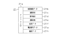
図2は、地図データ21のデータ構成を説明する概念図である。地図データ21は、メッシュID21a毎に、地図描画データ21b、道路形状21c、案内地点21d、道路名称21e、住所データ21f、電話番号データ21g、施設情報としての施設データ21hを有している。地図描画データ21bは、地図を描画するためのデータであって、地図上に線を描画するためのベクトル座標や、ポリゴンの点座標等を有している。道路形状21cは、各ノードの間に配置された形状補間点等の座標を示すデータである。案内地点21dは、主要な分岐点の名称や、案内表示板の内容等に関するデータである。住所データ21fは、目的地を住所から検索するためのデータであって、各メッシュ内の行政区分(都道府県、市区町村)名称等が含まれている。電話番号データ21gは、目的地を電話番号から検索するためのデータであって、各メッシュ内の市外局番等が記憶されている。
FIG. 2 is a conceptual diagram for explaining the data structure of the
また、施設データ21hは、そのメッシュ内にある各施設に関するデータである。この施設データ21hについて、図3に従って説明する。施設データ21hは、メッシュ内にある各施設毎に記憶され、施設名称21i、カテゴリ21j、座標21kを有している。施設名称21iは、その施設の名称である。カテゴリ21jは、「空港」、「ショッピングセンター」、「病院」、「駅」、「ガソリンスタンド」、「レストラン」等の施設のカテゴリを示す。座標21kは、その施設の緯度、経度等の座標を示す。尚、この施設データ21hは、メッシュ毎に格納されなくてもよく、施設データ21hのデータベースを独自に構成するようにしてもよい。また、この他にも施設の営業時間や、過去にユーザが立ち寄ったことがあるか否かを示す履歴等を記憶するようにしてもよい。
The
画像プロセッサ15は、自車位置周辺又はユーザが指定した地域の地図データ21を読み出し、ディスプレイ7に地図画面Mを出力する。このとき、画像プロセッサ15は、初期設定の地図縮尺、又はユーザが指定した地図縮尺をRAM11又は他のメモリから取得し、その縮尺に応じた地図データ21を出力する。広域(縮尺が小さい)を示す地図画面Mでは、高速道路、国道等の主要道路が表示され、細街路は非表示とされる。また、狭域(縮尺が大きい)の地図画面Mでは、主要道路だけでなく、広域の地図画面Mでは非表示にされる細街路が表示される。
The
画像データ記憶部6には、アイコンデータ22、表示優先度リスト23が記憶されている。アイコンデータ22は、地図画面M上に施設の位置を示すアイコン30(図1参照)を表示するためのベクトルデータ又はビットマップデータである。
The image
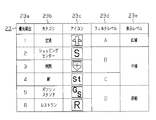
図4に示すように、表示優先度リスト23は、各施設のカテゴリ毎に、アイコンの優先度を示している。カテゴリ23bには、「空港」、「ショッピングセンター」、「病院」等があり、各カテゴリ23bに対し、優先順位23aが付与されている。アイコン23c
は、各カテゴリ23bに対応するアイコンであって、実際にはアイコンデータ22のファイル名等の識別子が記憶される。フィルタレベル23dは、各アイコンを重み付けしたレベル値が記憶されている。例えば、「空港」は優先度が高い「レベルA」、「ショッピングセンター」及び「病院」は、レベルAよりも優先度が低い「レベルB」に設定されている。このフィルタレベル23dは、地図画面Mに表示するアイコン30を間引きする場合に用いられる。
As shown in FIG. 4, the
Is an icon corresponding to each
タッチパネルコントローラ8は、タッチパネルであるディスプレイ7にユーザの指が接触した際に、その接触位置を検出し、位置検出信号をCPU10に出力する。CPU10は接触位置と画面の構成とを比較し、ユーザの命令を解析する。例えば、目的地設定画面において、目的地リストのうち一つがタッチパネル操作により指定された場合には、CPU10は、タッチパネルコントローラ8から位置検出信号を入力して、指定された目的地を判断する。そして、目的地を設定し、その目的地の座標等をRAM11又は図示しないメモリに記憶する。
The touch panel controller 8 detects the contact position when a user's finger contacts the display 7 which is a touch panel, and outputs a position detection signal to the
次に、本実施形態の処理手順について図5に従って説明する。まず、CPU10は、地図画面Mの表示開始を待機する(ステップS1)。例えば、CPU10は、イグニッションスイッチ(図示略)等からオン信号を入力した際に、その信号をトリガとして地図画面Mの表示を開始する。
Next, the processing procedure of this embodiment will be described with reference to FIG. First, the
地図画面Mの表示を開始すると判断すると(ステップS1においてYES)、地図画面Mに表示する施設を検索するための検索中心点を設定する(ステップS2)。このとき、CPU10は、現在の自車位置等を検索中心点とする。
If it is determined that the display of the map screen M is to be started (YES in step S1), a search center point for searching for facilities to be displayed on the map screen M is set (step S2). At this time, the
検索中心点を設定すると、CPU10は、地理情報記憶部5に記憶された施設データ21hを用いて検索中心点に近い施設を順番に抽出する(ステップS3)。このとき、CPU10は、各施設の座標21kと検索中心点との相対距離を演算し、該相対距離が短い施設から順に抽出してもよい。或いは、検索中心点から、道路沿いに施設までの距離を演算し、その距離が短い施設から順に抽出してもよい。
When the search center point is set, the
CPU10は、一つの施設を抽出すると、抽出した施設が隣接する道路の属性を判断し、該施設の道路属性が、所定レベル未満であるか否かを判断する(ステップS4)。例えば、所定レベルを「国道又は県道」等の道路種別とし、施設が隣接する道路が「国道又は県道」未満のレベルの道路であるか否かを判断するようにしてもよい。例えば、図6に従って説明すると、主要道路R1沿いの施設(図ではアイコン30I)に対しては、施設に隣接する道路の属性が所定レベル以上であると判断する。また、細街路R2沿いの施設(図ではアイコン30J)に対しては、施設に隣接する道路の属性が所定レベル未満であると判断する。尚、施設に隣接する道路は、その施設の座標21kに最も近い道とする。施設が、複数の異なる属性の道路に面している場合には、国道、県道等の上位の道路について判断する。
When extracting one facility, the
或いは、所定レベルを、その時点で選択されている地図縮尺において、地図画面Mに表示される道路種別のレベルとしてもよい。そして、施設が隣接する道路の属性が、その時点で選択されている地図縮尺において非表示にされる道路の属性である場合には、施設が隣接する道路の属性が所定レベル未満であると判断してもよい。 Alternatively, the predetermined level may be the level of the road type displayed on the map screen M at the map scale selected at that time. If the attribute of the road adjacent to the facility is the attribute of the road that is hidden at the map scale selected at that time, it is determined that the attribute of the road adjacent to the facility is less than a predetermined level. May be.
或いは、所定レベルを、自車が現在走行している道路種別のレベルとし、施設が隣接する道路の属性が、自車が現在走行している道路の属性よりも、下位のレベルの道路である場合には、所定レベル未満であると判断してもよい。或いは、施設が隣接する道路の属性が、自車が現在走行している道路沿いではない場合に、所定レベル未満であると判断して
もよい。
Alternatively, the predetermined level is set to the level of the road type on which the host vehicle is currently traveling, and the attribute of the road adjacent to the facility is a lower level road than the attribute of the road on which the host vehicle is currently traveling. In this case, it may be determined that the level is lower than a predetermined level. Alternatively, it may be determined that the attribute of the road adjacent to the facility is less than a predetermined level when the vehicle is not along the road on which the vehicle is currently traveling.
施設の道路属性が所定レベル以上であると判断すると(ステップS4においてNO)、ステップS6に進む。施設の道路属性が、所定レベル未満であると判断すると(ステップS4においてYES)、道路属性に基づき、所定レベル未満に該当する施設を間引く(ステップS5)。このとき、CPU10は、所定レベル未満の施設を非表示とする。例えば、所定レベルが「国道又は県道といった道路種別である場合には、図6中、細街路R2沿いの施設(図ではアイコン30J)を間引く対象とする。
If it is determined that the road attribute of the facility is equal to or higher than the predetermined level (NO in step S4), the process proceeds to step S6. If it is determined that the road attribute of the facility is lower than the predetermined level (YES in step S4), the facilities corresponding to the predetermined level or lower are thinned out based on the road attribute (step S5). At this time, the
ステップS6では、所定レベル以上の施設の施設情報をRAM11又は図示しないフラッシュメモリ等に記憶する(ステップS6)。図6の場合、主要道路R1沿いの施設(図ではアイコン30I)の施設情報を記憶する。施設情報は、施設データ21h全部でもよいし、施設名称21iのみでもよい。これにより、地図画面M上に表示する施設の施設情報が上記メモリに蓄積される。このとき、道路属性に基づいて予め間引きするため、全体として施設情報をロードする際にかかる時間を短縮化できるとともに、上記メモリの空き領域の消費を抑制することができる。
In step S6, the facility information of the facility of a predetermined level or higher is stored in the
そして、CPU10は、検索中心点を基準とした範囲内の全ての施設について検索終了したか否かを判断する(ステップS7)。例えば、検索中心点を中心に所定距離範囲内の施設を全て検索した場合には、検索終了であると判断する。検索終了であると判断した場合には(ステップS7においてYES)、ステップS8に進む。検索中心点の周辺において、まだ検出していない施設がある場合には、検索終了でないと判断して(ステップS7においてNO)、ステップS3に戻る。そして、検索中心点の周辺の全ての施設を検出し終わるまで、ステップS3〜ステップS7を繰り返す。その結果、上記メモリには、所定レベル以上の道路に隣接する施設の施設情報が蓄積される。
Then, the
全ての施設を検索し終わると、ステップS8では、CPU10は、上記メモリに記憶された施設情報を用いて、各施設のアイコン30を表示した際に、アイコン30の重なりがあるか否かを判断する(ステップS8)。このステップでは、施設データ21hを用いて、各施設の道路属性に基づく間引きを行っても、重なりが生じるアイコン30を間引きする。このときCPU10は、施設データ21hの座標21kと予め記憶したアイコン30の幅及び長さとに基づき、地図画面Mを表示するための画面座標系でのアイコン30が占有する領域を演算し、互いに隣り合う各アイコン30が重なるか否かを判断する。例えば、図7に示すように、アイコン30Aの一部にアイコン30Bが重なっている場合、アイコン30A自身の幅W1と、アイコン30Bによって遮られていない領域の幅W2との比(W2/W1)を算出する。さらに、その比(W2/W1)が所定値K未満であるか否かを判断し(所定値Kは1以下)、所定値K未満である、即ちアイコン30の重複が大きいと判断した場合には、アイコン30Aの重複が大きいと判断する。この所定値Kを「1」に設定して、アイコン30が僅かでも重なる場合には、全て重なりが生じる渡判断してもよい。或いは、所定値Kを、各アイコン30が重なっても、施設のカテゴリを判別することができる状態に応じた閾値に設定し、僅かな重なりであれば許容するようにしてもよい。
When all the facilities are searched, in step S8, the
ステップS8においてアイコン30の重なりが無いと判断すると(ステップS8においてNO)、画像プロセッサ15は、地図画面Mを出力する(ステップS10)。このとき、画像プロセッサ15は、自車位置周辺の地図データ21を読み出し、地図データ21、自車位置を示すアイコン、操作ボタン等を重ねてディスプレイ7に出力する。また、メモリに蓄積された施設情報を読み出し、該施設情報に該当するカテゴリのアイコンデータ22を読み込み、アイコンデータ22に基づくアイコン30を地図画面M上に表示する。
If it is determined in step S8 that the
一方、ステップS8においてアイコン30の重なりがあると判断すると(ステップS8においてYES)、重なったアイコン30を間引きする(ステップS9)。本実施形態では、CPU10は、互いに重なった各アイコン30のフィルタレベル23dを表示優先度リスト23に基づき判断する。そして、フィルタレベル23dが一定レベル(例えば「レベルC」)以下のアイコン30を非表示にする。
On the other hand, if it is determined in step S8 that the
間引きは、図8(a)に示すように、各アイコン30が重なった状態から、重複部分が全く無い状態までアイコン30の間引きを行うようにしてもよい。又は、図8(b)に示すように、重なったアイコン30のうち、重なりが大きいアイコン30のみを非表示にして、各アイコン30の一部が重なっているが、各アイコン30が示す施設のカテゴリが判別可能な状態になるまで間引きを行うようにしてもよい。
As shown in FIG. 8A, the thinning may be performed by thinning the
また、表示優先度リスト23以外の条件を用いて間引きを行うようにしてもよい。例えば現在時刻に対して営業している店舗のアイコン30を優先的に表示してもよいし、ユーザが過去に利用又は検索した施設等、ユーザの嗜好に応じた施設のアイコン30を優先的に表示してもよい。
Further, thinning may be performed using conditions other than the
間引きを行うと、画像プロセッサ15は、図9に示すように、アイコン30が間引きされた地図画面Mを出力する(ステップS10)。その結果、施設が密集している地域であっても、各アイコン30を判別しやすく表示することができる。
When thinning is performed, the
地図画面Mを表示すると、CPU10は、地図画面Mの表示を終了するか否かを判断する(ステップS11)。例えば、目的地に到着した場合、又はイグニッションスイッチからオフ信号を入力した場合、又はユーザにより地図画面表示を終了するための操作が行われた場合、表示を終了すると判断して(ステップS11においてYES)、上記処理を終了する。表示終了でないと判断した場合には(ステップS11においてNO)、ステップS2に戻り、上記した処理を繰り返す。
When the map screen M is displayed, the
第1実施形態によれば、以下のような効果を得ることができる。
(1)第1実施形態では、ナビゲーションシステム1のCPU10は、検索中心点を中心とした所定距離範囲の施設を抽出し、各施設に隣接する道路の属性を地図データ21に基づき取得した。また、取得した道路属性が所定レベル未満であるか否かを判断するようにした。さらに、所定レベル未満の施設を間引き、所定レベル以上の施設のアイコン30を地図画面M上に表示するようにした。このため、広域の地図縮尺が設定され、施設が密集した地域の地図を表示する場合であっても、ユーザにとって必要性が高いアイコン30を、見やすい状態で表示することができる。
According to the first embodiment, the following effects can be obtained.
(1) In the first embodiment, the
(2)第1実施形態では、CPU10は、その時点で設定されている地図縮尺では非表示とされる道路の属性を取得し、非表示とされた道路に隣接する施設のアイコン30を非表示とするようにした。このため、ユーザにとって必要性の低いアイコン30を的確に間引くことができる。
(2) In the first embodiment, the
(第2実施形態)
次に、本発明を具体化した第2の実施形態を図10に従って説明する。尚、第2の実施形態は、第1の実施形態の処理手順の一部を変更したのみの構成であるため、同様の部分についてはその詳細な説明を省略する。
(Second Embodiment)
Next, a second embodiment of the present invention will be described with reference to FIG. Since the second embodiment has a configuration in which only a part of the processing procedure of the first embodiment is changed, detailed description of the same parts is omitted.
ナビゲーションシステム1のCPU10は、第1実施形態と同様に、地図画面Mの表示を待機し(ステップS1)、地図画面Mの表示を開始すると判断すると(ステップS1においてYES)、検索中心点を設定し(ステップS2)、検索中心点に近い施設から順番
に抽出する(ステップS3)。
As in the first embodiment, the
そして、CPU10は、隣り合うアイコン30の重なりがあるか否かを判断する(ステップS20)。アイコン30の重なりが無いと判断すると(ステップS20においてNO)、ステップS22に進み、施設情報を上記メモリに記憶する。アイコン30の重なりがあると判断すると(ステップS20においてYES)、施設情報に基づき間引きを行う(ステップS21)。即ち、第1実施形態では、重複の有無に関わらず、施設が隣接する道路属性が所定レベル未満であるアイコン30を間引くようにしたが、第2実施形態では重複が生じた場合のみ、施設情報に基づく間引きを行う。例えば第1実施形態と同様に、CPU10は、重なりが生じたアイコン30に対応する施設が隣接する道路を判断し、該道路の属性を取得する。さらに、取得した道路属性が所定レベル以上であるか否かを判断し、所定レベル未満である場合にはその施設を間引く対象とする。
Then, the
さらにCPU10は、間引かれなかった施設の施設情報をメモリに記憶する(ステップS22)。そして、検索中心点を中心とした所定距離範囲内の全ての施設を検出したか否か判断し(ステップS23)、検出が終了したと判断した場合には(ステップS23においてYES)、ステップS24に進む。
Further, the
ステップS24では、地図画面Mの見やすさを向上させるために、上記メモリに記憶されたアイコン30に対し、重なりがあるか否かを第1実施形態のステップS8と同様に判断する。ステップS21で間引き処理を行った場合でも、アイコン30に重なりがあると判断した場合には、さらにアイコン30を間引いて、各アイコン30が示す情報を判別可能な状態にする。アイコン30を間引くと、画像プロセッサ15は、上記メモリに記憶された施設情報に基づき、施設を示すアイコン30を表示した地図画面Mを出力する(ステップS26)。
In step S24, in order to improve the visibility of the map screen M, it is determined in the same manner as in step S8 of the first embodiment whether or not there is an overlap with the
従って、第2実施形態によれば、第1の実施形態に記載の効果に加えて以下の効果を得ることができる。
(3)第2実施形態では、ナビゲーションシステム1のCPU10は、検索中心点を中心とした所定距離範囲の施設を抽出し、隣合うアイコン30が重なるか否かを判断するようにした。さらに、重なりが生じる場合には、各施設に隣接する道路の属性を地図データ21に基づき取得し、該道路属性が所定レベル未満であるか否かを判断するようにした。さらに、所定レベル未満である施設を間引き、所定レベル以上である施設のアイコン30を地図画面M上に表示するようにした。このため、広域の地図縮尺が設定され、施設が密集した地域の地図を表示する場合であっても、ユーザにとって必要性が高いアイコン30を、見やすい状態で表示することができる。また、アイコン30の重なりが生じない場合には、その施設に隣接する道路の属性が所定レベル未満であるとしても間引かないので、自車位置周辺の施設に関する情報を可能な限り多く提供することができる。
Therefore, according to the second embodiment, the following effects can be obtained in addition to the effects described in the first embodiment.
(3) In the second embodiment, the
地理情報記憶部5に記憶される施設データには、各施設の位置情報、カテゴリ情報、非表示条件(隣接道路属性や地図縮尺などにより設定された表示条件など)、ランドマークなどが含まれる。ユーザの施設情報の表示指示に従って、ナビユニット2は地図上に表示する施設を検索し、検索された施設のランドマークの表示処理を行うが、前記ランドマークが重なってしまう場合には、隣接する道路の道路属性の高い施設のランドマークを優先的に表示するよう制御する。例えば、検索された施設のランドマークが地図上で重なるか否かの重なり判定を行い、ランドマークが重なって表示されるとナビユニット2により判断された場合には、施設データの非表示条件に基づき、検索されたランドマークを地図上に表示するか否かを決定する。例えば、縮尺Aでは、国道に隣接する施設を表示する。縮尺Bでは、国道・県道に隣接する施設を表示する。このように制御することにより、ユーザの利用しやすい施設を識別しやすく提供することができる。
The facility data stored in the geographic
尚、上記各実施形態は以下のように変更してもよい。
・上記実施形態では、ナビゲーションシステム1は、道路属性記憶手段としての地理情報記憶部5を備えるようにしたが、これを省略しても良い。即ち、ナビゲーションシステム1の外部から道路属性を取得するようにしてもよい。また、ナビユニット2は、道路属性取得手段として機能しなくてもよい。
In addition, you may change each said embodiment as follows.
In the above embodiment, the
・上記実施形態では、ステップS2において、現在の自車位置を検索中心点としたが、ユーザが指定した地点を検索中心点としてもよい。 In the above embodiment, the current vehicle position is set as the search center point in step S2, but a point designated by the user may be set as the search center point.
1…ナビゲーションシステム、2…ナビゲーション装置としてのナビゲーションユニット、5…地図データ記憶手段、道路属性情報記憶手段、施設情報記憶手段としての地理情報記憶部、10…抽出手段、道路属性取得手段、表示判断手段、出力制御手段としてのCPU、15…出力制御手段としての画像プロセッサ、20…属性情報としての経路データ、21…地図データ、30…施設指標としてのアイコン。
DESCRIPTION OF
Claims (8)
地図への表示対象の施設を前記施設情報記憶手段から抽出する抽出手段と、
前記属性情報に基づき、施設に隣接する道路の属性を取得する道路属性取得手段と、
施設に隣接する道路の属性に基づき、該施設の位置を示す前記施設指標の表示の可否を判断する表示判断手段と、
前記表示判断手段により非表示とすると判断された前記施設指標を間引き、表示する前記施設指標を前記地図データに基づく地図上に表示する出力制御手段と
を備えたことを特徴とするナビゲーション装置。 A map data storage means storing map data, a road attribute storage means storing road attribute information, and a facility information storage means storing facility information are used, and a facility index indicating the location of the facility is based on the map data. In a navigation device that displays on a map,
Extraction means for extracting the facility to be displayed on the map from the facility information storage means;
Road attribute acquisition means for acquiring an attribute of a road adjacent to the facility based on the attribute information;
Display determination means for determining whether or not to display the facility index indicating the location of the facility based on the attribute of the road adjacent to the facility;
A navigation apparatus comprising: output control means for thinning out the facility index determined not to be displayed by the display determination means and displaying the facility index to be displayed on a map based on the map data.
前記表示判断手段は、前記地図において非表示とされる道路の属性を取得し、表示対象の施設のうち、該非表示とされる属性の道路に隣接する前記施設の前記施設指標を非表示とすることを特徴とするナビゲーション装置。 The navigation device according to claim 1, wherein
The display determination unit acquires an attribute of a road that is hidden in the map, and hides the facility index of the facility adjacent to the road with the attribute that is hidden among the facilities to be displayed. A navigation device characterized by that.
前記表示判断手段は、表示対象の前記施設に隣接する道路の属性を取得し、該道路属性が、所定の道路種別よりも下位のレベルである前記施設の前記施設指標を非表示とすることを特徴とするナビゲーション装置。 The navigation device according to claim 1, wherein
The display determination unit acquires an attribute of a road adjacent to the facility to be displayed, and hides the facility index of the facility whose road attribute is at a lower level than a predetermined road type. A featured navigation device.
前記表示判断手段は、表示対象の前記施設のうち、前記施設に隣接する道路が、自車両が現在走行している道路以外である場合に、前記施設の該施設指標を非表示とすることを特徴とするナビゲーション装置。 The navigation device according to claim 1, wherein
The display determination means is configured to hide the facility index of the facility when the road adjacent to the facility is a road other than the road on which the host vehicle is currently traveling among the facilities to be displayed. A featured navigation device.
前記表示判断手段は、表示対象である前記施設の前記施設指標に重なりがあるか否かを判断し、重なりがあると判断した前記施設指標に対し、前記施設に隣接する道路の属性に基づき、前記施設指標の表示の可否を判断することを特徴とするナビゲーション装置。 In the navigation apparatus of any one of Claims 1-4,
The display determining means determines whether or not there is an overlap in the facility index of the facility to be displayed, and for the facility index determined to have an overlap, based on an attribute of a road adjacent to the facility, A navigation device that determines whether or not the facility index can be displayed.
地図への表示対象の施設を前記施設情報記憶手段から抽出する抽出手段と、
施設に隣接する道路の属性に基づき、該施設の位置を示す前記施設指標の表示の可否を判断する表示判断手段と、
前記表示判断手段により非表示とすると判断された前記施設指標を間引き、表示する前記施設指標を前記地図データに基づく地図上に表示する出力制御手段と
を備えたことを特徴とするナビゲーション装置。 In a navigation apparatus for displaying a facility index indicating the location of a facility on a map based on the map data, using a map data storage unit storing map data and a facility information storage unit storing facility information.
Extraction means for extracting the facility to be displayed on the map from the facility information storage means;
Display determination means for determining whether or not to display the facility index indicating the location of the facility based on the attribute of the road adjacent to the facility;
A navigation apparatus comprising: output control means for thinning out the facility index determined not to be displayed by the display determination means and displaying the facility index to be displayed on a map based on the map data.
地図への表示対象の施設を抽出し、前記道路属性記憶手段から、施設に隣接する道路の属性を取得するとともに、
施設に隣接する道路の属性に基づき、該施設の位置を示す前記施設指標の表示の可否を判断し、非表示とすると判断した前記施設指標を間引き、表示する前記施設指標を前記地
図データに基づく地図上に表示することを特徴とする案内方法。 A map data storage means storing map data, a road attribute storage means storing road attribute information, and a facility information storage means storing facility information are used, and a facility index indicating the location of the facility is based on the map data. In the guidance method displayed on the map,
Extract the facility to be displayed on the map, acquire the attribute of the road adjacent to the facility from the road attribute storage means,
Based on the attribute of the road adjacent to the facility, it is determined whether the facility index indicating the location of the facility can be displayed, the facility index determined to be hidden is thinned, and the facility index to be displayed is based on the map data A guidance method characterized by displaying on a map.
前記制御手段を、
地図への表示対象の施設を抽出する抽出手段と、
前記道路属性記憶手段から、施設に隣接する道路の属性を取得する道路属性取得手段と、
施設に隣接する道路の属性に基づき、該施設の位置を示す前記施設指標の表示の可否を判断する表示判断手段と、
前記表示判断手段により非表示とすると判断された前記施設指標を間引き、表示する前記施設指標を前記地図データに基づく地図上に表示する出力制御手段として機能させることを特徴とする案内プログラム。 Using the map data storage means storing the map data, the road attribute storage means storing the road attribute information, the facility information storage means storing the facility information, and the control means, the facility index indicating the location of the facility is In a guidance program that displays on a map based on map data,
The control means;
An extraction means for extracting facilities to be displayed on the map;
Road attribute acquisition means for acquiring an attribute of a road adjacent to the facility from the road attribute storage means;
Display determination means for determining whether or not to display the facility index indicating the location of the facility based on the attribute of the road adjacent to the facility;
A guidance program that thins out the facility index determined to be non-displayed by the display determination unit and functions as an output control unit that displays the facility index to be displayed on a map based on the map data.
Priority Applications (1)
| Application Number | Priority Date | Filing Date | Title |
|---|---|---|---|
| JP2007176233A JP2009014486A (en) | 2007-07-04 | 2007-07-04 | Navigation device, and guiding method and program |
Applications Claiming Priority (1)
| Application Number | Priority Date | Filing Date | Title |
|---|---|---|---|
| JP2007176233A JP2009014486A (en) | 2007-07-04 | 2007-07-04 | Navigation device, and guiding method and program |
Publications (1)
| Publication Number | Publication Date |
|---|---|
| JP2009014486A true JP2009014486A (en) | 2009-01-22 |
Family
ID=40355577
Family Applications (1)
| Application Number | Title | Priority Date | Filing Date |
|---|---|---|---|
| JP2007176233A Pending JP2009014486A (en) | 2007-07-04 | 2007-07-04 | Navigation device, and guiding method and program |
Country Status (1)
| Country | Link |
|---|---|
| JP (1) | JP2009014486A (en) |
Cited By (9)
| Publication number | Priority date | Publication date | Assignee | Title |
|---|---|---|---|---|
| JP2011052981A (en) * | 2009-08-31 | 2011-03-17 | Toyota Mapmaster:Kk | Method and device of creating road information, computer program for creating road information, and recording medium recording the computer program |
| JP2011081198A (en) * | 2009-10-07 | 2011-04-21 | Zenrin Datacom Co Ltd | Map information processing device, map information processing method, and map information processing program |
| JP2013061510A (en) * | 2011-09-14 | 2013-04-04 | Zenrin Datacom Co Ltd | Map note processing apparatus and map note processing method |
| JP2014209139A (en) * | 2013-04-16 | 2014-11-06 | アイシン・エィ・ダブリュ株式会社 | Spot display system, method, and program |
| JP2014229161A (en) * | 2013-05-24 | 2014-12-08 | アルパイン株式会社 | Information processing system and computer program |
| JP2016109504A (en) * | 2014-12-04 | 2016-06-20 | クラリオン株式会社 | On-vehicle device |
| JP2016201146A (en) * | 2016-08-25 | 2016-12-01 | カシオ計算機株式会社 | Information display device, information display method, and information display program |
| JP2020047205A (en) * | 2018-09-21 | 2020-03-26 | 株式会社日立国際電気 | Route display method |
| CN111831664A (en) * | 2019-04-16 | 2020-10-27 | 北京四维图新科技股份有限公司 | Map data updating method and device |
-
2007
- 2007-07-04 JP JP2007176233A patent/JP2009014486A/en active Pending
Cited By (10)
| Publication number | Priority date | Publication date | Assignee | Title |
|---|---|---|---|---|
| JP2011052981A (en) * | 2009-08-31 | 2011-03-17 | Toyota Mapmaster:Kk | Method and device of creating road information, computer program for creating road information, and recording medium recording the computer program |
| JP2011081198A (en) * | 2009-10-07 | 2011-04-21 | Zenrin Datacom Co Ltd | Map information processing device, map information processing method, and map information processing program |
| JP2013061510A (en) * | 2011-09-14 | 2013-04-04 | Zenrin Datacom Co Ltd | Map note processing apparatus and map note processing method |
| JP2014209139A (en) * | 2013-04-16 | 2014-11-06 | アイシン・エィ・ダブリュ株式会社 | Spot display system, method, and program |
| JP2014229161A (en) * | 2013-05-24 | 2014-12-08 | アルパイン株式会社 | Information processing system and computer program |
| JP2016109504A (en) * | 2014-12-04 | 2016-06-20 | クラリオン株式会社 | On-vehicle device |
| JP2016201146A (en) * | 2016-08-25 | 2016-12-01 | カシオ計算機株式会社 | Information display device, information display method, and information display program |
| JP2020047205A (en) * | 2018-09-21 | 2020-03-26 | 株式会社日立国際電気 | Route display method |
| JP7177642B2 (en) | 2018-09-21 | 2022-11-24 | 株式会社日立国際電気 | Route display method |
| CN111831664A (en) * | 2019-04-16 | 2020-10-27 | 北京四维图新科技股份有限公司 | Map data updating method and device |
Similar Documents
| Publication | Publication Date | Title |
|---|---|---|
| JP4145028B2 (en) | POI icon display method and navigation device | |
| US7076741B2 (en) | Point-of-interest icon and point-of-interest mark display method | |
| JP4674481B2 (en) | Car navigation system | |
| JP2009014486A (en) | Navigation device, and guiding method and program | |
| JP2007240400A (en) | Navigation device and plural route uniting method | |
| JP4849237B2 (en) | Traveling route guidance device for vehicles | |
| JP2006329678A (en) | In-vehicle navigation device | |
| JP5748186B2 (en) | Facility search device | |
| JP2006201072A (en) | Navigation apparatus | |
| US9835459B2 (en) | Electronic device, and method and program for displaying name of search object candidate | |
| JP2007212857A (en) | Navigation device | |
| JP2008076359A (en) | On-vehicle navigation system, preparation method for searching data, and search method for guide route | |
| JP4248964B2 (en) | Navigation device, facility list display method and program | |
| JP2007333654A (en) | Navigation system | |
| JP2005164543A (en) | Navigation device and guiding method of peripheral facility | |
| JP4048948B2 (en) | Navigation device | |
| JP3009681B2 (en) | Navigation device | |
| JP4661336B2 (en) | Navigation device, display method, and information retrieval method | |
| JP3325245B2 (en) | Navigation device | |
| JP2007257208A (en) | Facility retrieval device, method, and program therefor | |
| JP4421928B2 (en) | Navigation device | |
| JP4455173B2 (en) | Navigation device | |
| JP4808175B2 (en) | Method for arranging road index on map data in navigation device | |
| JP2011242363A (en) | Navigation device and destination setting method therefor | |
| JP2859757B2 (en) | In-vehicle navigator |