JP2005294931A - Wireless portable terminal and position information system - Google Patents
Wireless portable terminal and position information system Download PDFInfo
- Publication number
- JP2005294931A JP2005294931A JP2004103062A JP2004103062A JP2005294931A JP 2005294931 A JP2005294931 A JP 2005294931A JP 2004103062 A JP2004103062 A JP 2004103062A JP 2004103062 A JP2004103062 A JP 2004103062A JP 2005294931 A JP2005294931 A JP 2005294931A
- Authority
- JP
- Japan
- Prior art keywords
- portable terminal
- wireless
- wireless portable
- position information
- detecting
- Prior art date
- Legal status (The legal status is an assumption and is not a legal conclusion. Google has not performed a legal analysis and makes no representation as to the accuracy of the status listed.)
- Withdrawn
Links
Images

Landscapes
- Mobile Radio Communication Systems (AREA)
- Telephone Function (AREA)
- Telephonic Communication Services (AREA)
- Position Fixing By Use Of Radio Waves (AREA)
Abstract
【課題】 無線携帯端末を保持する姿勢によらず、方位を確実に検出できる無線携帯端末を提供する。
【解決手段】 無線携帯端末1内には、互いに直交する方向に配置された一対の地磁気センサ28、29が設けられている。地磁気センサ28は無線携帯端末1の筐体の長手方向に設置されており、無線携帯端末1が地面に対して略水平である場合、地磁気センサ28によって方位が計測可能である。一方、地磁気センサ29は無線携帯端末1の筐体の短手方向に設置されており、無線携帯端末1が地面に対して略垂直である場合、地磁気センサ29によって方位が計測可能である。
【選択図】 図2PROBLEM TO BE SOLVED: To provide a wireless portable terminal capable of reliably detecting an azimuth regardless of a posture for holding the wireless portable terminal.
A pair of geomagnetic sensors (28, 29) arranged in directions orthogonal to each other are provided in a wireless portable terminal (1). The geomagnetic sensor 28 is installed in the longitudinal direction of the casing of the wireless portable terminal 1. When the wireless portable terminal 1 is substantially horizontal with respect to the ground, the orientation can be measured by the geomagnetic sensor 28. On the other hand, the geomagnetic sensor 29 is installed in the short direction of the casing of the wireless portable terminal 1, and the orientation can be measured by the geomagnetic sensor 29 when the wireless portable terminal 1 is substantially perpendicular to the ground.
[Selection] Figure 2
Description
本発明は、位置情報を取得する無線携帯端末、及びこの無線携帯端末の位置情報に基づいて位置情報サービスを提供する位置情報システムに関する。 The present invention relates to a wireless portable terminal that acquires position information and a position information system that provides a position information service based on the position information of the wireless portable terminal.
無線携帯端末としてGPS機能が搭載された携帯電話端末を用い、この携帯電話端末で取得した位置情報を無線ネットワークに送信し、無線ネットワークより携帯電話端末の現在地周辺の地図情報を提供する位置情報サービスが実用化されている。この位置情報サービスでは、方位計を搭載した携帯電話端末が実用化されており、自端末で計測された方位情報を基に、受信した地図情報の上に自分の向いている方位を表示する。 A location information service that uses a mobile phone terminal equipped with a GPS function as a wireless mobile terminal, transmits location information acquired by the mobile phone terminal to a wireless network, and provides map information around the current location of the mobile phone terminal from the wireless network Has been put to practical use. In this position information service, a mobile phone terminal equipped with an azimuth meter has been put into practical use, and based on the azimuth information measured by the own terminal, the azimuth that the user is facing is displayed on the received map information.
また、無線携帯端末としてPHS(登録商標)端末を用いて位置情報サービスを提供することも実現されている。この場合、無線携帯端末により周辺に位置する無線基地局の識別符号(以下、CS−IDと記載する)を取得して、このCS−IDを無線基地局側の無線ネットワークに送信し、無線ネットワークにおいて、CS−IDに基づいて無線携帯端末の位置を検出し、現在地周辺の地図等の位置情報サービスを提供する。 In addition, providing a location information service using a PHS (registered trademark) terminal as a wireless portable terminal is also realized. In this case, an identification code (hereinafter referred to as CS-ID) of a wireless base station located in the vicinity is acquired by the wireless portable terminal, and this CS-ID is transmitted to the wireless network on the wireless base station side. The position of the wireless portable terminal is detected based on the CS-ID, and a location information service such as a map around the current location is provided.
また、携帯端末装置として、磁気センサを用いて方位を検出し、検出された方位を基に、ディスプレイに表示される地図情報を回転させるものが知られている(特許文献1参照)。また、目的地情報を入力し、この目的地情報および携帯電話端末の現在位置を方位表示システムに送信すると、方位表示システムは、現在位置から目的地への方位と距離を算出して携帯電話端末に返送し、携帯電話端末は、目的地への方位を、矢印で距離とともに表示するものが知られている(特許文献2参照)。 As a portable terminal device, a device that detects a direction using a magnetic sensor and rotates map information displayed on a display based on the detected direction is known (see Patent Document 1). When the destination information is input and the destination information and the current position of the mobile phone terminal are transmitted to the azimuth display system, the azimuth display system calculates the azimuth and distance from the current position to the destination. The mobile phone terminal is known to display the direction to the destination together with the distance with an arrow (see Patent Document 2).
しかしながら、上記従来例では、所有者が無線携帯端末を保持する姿勢によっては、地磁気センサによって方位を計測できない場合があり、その改善が要望されていた。すなわち、無線携帯端末に方位計測手段として搭載される地磁気センサは、地磁気とコイル発生磁界との合成磁界を検出することにより方位を計測するものであるが、地面に対して水平に設置された場合は方位を正常に計測可能であるが、地面に対して垂直に設置された場合は方位を計測できなかった。 However, in the above conventional example, depending on the attitude of the owner holding the wireless portable terminal, the azimuth cannot be measured by the geomagnetic sensor, and there has been a demand for improvement. In other words, the geomagnetic sensor mounted as a direction measuring means in the wireless portable terminal measures the direction by detecting the combined magnetic field of the geomagnetism and the coil generated magnetic field, but when installed horizontally with respect to the ground Can measure the direction normally, but it cannot measure the direction when installed perpendicular to the ground.
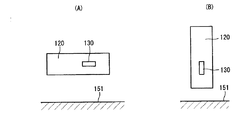
図14は従来例における無線携帯端末内に設置された地磁気センサの配置状態を示す図である。図14(A)は地面151に対して無線携帯端末120に搭載された地磁気センサ130が水平に配置された場合を示し、図14(B)は地面151に対して地磁気センサ130が垂直に配置された場合を示す。このように、無線携帯端末では、使用者が保持する際の端末筐体の向きが不定となることがある。このため、従来例の地磁気センサの配置構成では、方位を計測する際に無線携帯端末が特定姿勢となるように、使用者が所定の保持形態をとる必要があり、使い勝手があまりよくなかった。また、無線携帯端末の姿勢によっては、方位を正常に計測することができないため、無線ネットワークから提供される位置情報サービスを十分に活用できない場合があった。
FIG. 14 is a diagram showing an arrangement state of geomagnetic sensors installed in a wireless portable terminal in a conventional example. FIG. 14A shows a case where the
本発明は、上記事情に鑑みてなされたもので、無線携帯端末を保持する姿勢によらず、確実に方位を検出できる無線携帯端末を提供することを目的とする。また、本発明は、無線携帯端末で検出される方位情報に基づき、無線ネットワークから提供される位置情報サービスを十分に活用できる位置情報システムを提供することを目的とする。 The present invention has been made in view of the above circumstances, and an object of the present invention is to provide a wireless portable terminal that can reliably detect the azimuth regardless of the posture of holding the wireless portable terminal. Another object of the present invention is to provide a location information system that can fully utilize location information services provided from a wireless network based on azimuth information detected by a wireless portable terminal.
本発明の無線携帯端末は、筐体内に互いに異なる向きに配置され、それぞれ地磁気を検出する複数の地磁気検出手段と、前記複数の地磁気検出手段のいずれかを選択する選択手段と、前記選択された地磁気検出手段からの出力信号を基に、自端末が向いている方位を検出する方位検出手段とを備えるものである。 The wireless portable terminal of the present invention is arranged in different directions in the housing, each of which includes a plurality of geomagnetism detection means for detecting geomagnetism, a selection means for selecting one of the plurality of geomagnetism detection means, and the selected And azimuth detecting means for detecting the azimuth facing the terminal based on an output signal from the geomagnetism detecting means.
この構成により、無線携帯端末を保持する姿勢によらず、地磁気検出手段のいずれかによって方位を確実に検出可能となる。 With this configuration, it is possible to reliably detect the azimuth by any one of the geomagnetism detection means regardless of the posture in which the wireless portable terminal is held.
また、本発明の一態様として、上記の無線携帯端末であって、選択指示操作入力を行う選択操作部を備え、前記選択手段は、前記選択操作部の操作入力に従って前記複数の地磁気検出手段のいずれかを選択するものも含まれる。 According to another aspect of the present invention, the wireless portable terminal includes a selection operation unit that performs a selection instruction operation input, and the selection unit includes a plurality of geomagnetism detection units according to the operation input of the selection operation unit. The selection of either is also included.
この構成により、ユーザによる選択操作部の操作に基づく選択指示操作入力に応じて、地磁気検出手段のいずれかが選択され、この地磁気検出手段によって方位を確実に検出可能となる。 With this configuration, one of the geomagnetism detection means is selected in response to a selection instruction operation input based on the operation of the selection operation unit by the user, and the azimuth can be reliably detected by the geomagnetism detection means.
また、本発明の一態様として、上記の無線携帯端末であって、前記無線携帯端末の筐体の傾きを検出する傾き検出手段を備え、前記選択手段は、前記傾き検出手段の出力に基づいて前記複数の地磁気検出手段のいずれかを選択するものも含まれる。 According to another aspect of the present invention, the wireless portable terminal includes an inclination detection unit that detects an inclination of a casing of the wireless portable terminal, and the selection unit is based on an output of the inclination detection unit. A device that selects any one of the plurality of geomagnetic detection means is also included.
この構成により、傾き検出手段で検出された傾きに応じて、自動的に適切な地磁気検出手段が選択され、この地磁気検出手段によって方位を確実に検出可能となる。 According to this configuration, an appropriate geomagnetism detecting means is automatically selected according to the tilt detected by the tilt detecting means, and the azimuth can be reliably detected by the geomagnetism detecting means.
本発明の位置情報システムは、無線携帯端末とこの無線携帯端末に接続される無線ネットワークとを備え、前記無線携帯端末の位置情報に基づき、前記無線ネットワークのサーバより無線携帯端末に位置情報サービスを提供する位置情報システムであって、前記無線携帯端末は、筐体内に互いに異なる向きに配置され、それぞれ地磁気を検出する複数の地磁気検出手段と、前記複数の地磁気検出手段のいずれかを選択する選択手段と、前記選択された地磁気検出手段からの出力信号を基に、自端末が向いている方位を検出する方位検出手段と、前記検出された方位情報に基づき、前記提供された位置情報サービスの内容を処理する提供情報処理手段とを備えるものである。 The location information system of the present invention includes a wireless portable terminal and a wireless network connected to the wireless portable terminal, and provides a location information service from the server of the wireless network to the wireless portable terminal based on the location information of the wireless portable terminal. In the position information system to be provided, the wireless portable terminal is disposed in a housing in different directions, and each of the plurality of geomagnetism detection means for detecting geomagnetism and the selection for selecting one of the plurality of geomagnetism detection means Based on the output signal from the selected geomagnetism detection means, the direction detection means for detecting the direction in which the terminal is facing, and the location information service provided based on the detected direction information Provided information processing means for processing the contents.
この構成により、無線携帯端末では筐体の姿勢によらず確実に方位が検出され、この方位情報に基づき、無線ネットワークから提供される位置情報サービスの内容を処理することができ、位置情報サービスを十分に活用可能となる。 With this configuration, the wireless mobile terminal can reliably detect the orientation regardless of the orientation of the housing, and based on this orientation information, the content of the location information service provided from the wireless network can be processed. It can be fully utilized.
本発明の位置情報システムは、無線携帯端末とこの無線携帯端末に接続される無線ネットワークとを備え、前記無線携帯端末の位置情報に基づき、前記無線ネットワークのサーバより無線携帯端末に位置情報サービスを提供する位置情報システムであって、前記無線携帯端末は、筐体内に互いに異なる向きに配置され、それぞれ地磁気を検出する複数の地磁気検出手段と、前記複数の地磁気検出手段のいずれかを選択する選択手段と、前記選択された地磁気検出手段からの出力信号を基に、自端末が向いている方位を検出する方位検出手段と、前記検出された方位情報を前記無線ネットワークに送信する方位情報送信手段とを備えるものである。 The location information system of the present invention includes a wireless portable terminal and a wireless network connected to the wireless portable terminal, and provides a location information service from the server of the wireless network to the wireless portable terminal based on the location information of the wireless portable terminal. In the position information system to be provided, the wireless portable terminal is disposed in a housing in different directions, and each of the plurality of geomagnetism detection means for detecting geomagnetism and the selection for selecting one of the plurality of geomagnetism detection means Means, direction detecting means for detecting the direction in which the terminal is facing, based on an output signal from the selected geomagnetism detecting means, and direction information transmitting means for transmitting the detected direction information to the wireless network Are provided.
この構成により、無線携帯端末では筐体の姿勢によらず確実に方位が検出され、無線ネットワーク側では、無線携帯端末より送られる方位情報に基づいて位置情報サービスの内容を処理して無線携帯端末へ提供できるので、無線携帯端末側の負荷を軽減でき、位置情報サービスを十分に活用可能となる。 With this configuration, the wireless mobile terminal reliably detects the orientation regardless of the orientation of the housing, and the wireless network side processes the contents of the location information service based on the orientation information sent from the wireless mobile terminal. Therefore, the load on the wireless portable terminal can be reduced, and the location information service can be fully utilized.
また、本発明の一態様として、上記の位置情報システムであって、前記無線携帯端末は、自端末周辺の無線基地局の識別番号を取得する識別番号取得手段と、前記無線基地局からの送信信号の電界強度を検出する電界強度検出手段と、前記無線基地局の識別番号および電界強度を前記無線ネットワークに送信する基地局情報送信手段とを備え、前記無線ネットワークは、前記無線携帯端末より取得した無線基地局の識別番号および電界強度を基に、前記無線携帯端末の位置を検出する位置検出手段を備え、前記検出された位置情報に基づいて前記位置情報サービスを提供するものも含まれる。 In addition, as one aspect of the present invention, in the position information system described above, the wireless portable terminal includes an identification number acquisition unit that acquires an identification number of a wireless base station around the terminal, and a transmission from the wireless base station Electric field strength detecting means for detecting the electric field strength of the signal, and base station information transmitting means for transmitting the identification number and electric field strength of the wireless base station to the wireless network, wherein the wireless network is obtained from the wireless portable terminal There is also provided one that includes position detecting means for detecting the position of the wireless portable terminal based on the identification number and electric field strength of the wireless base station, and provides the position information service based on the detected position information.
この構成により、PHS(登録商標)の移動体通信システムにおける無線携帯端末および無線ネットワークに適用し、位置情報サービスを有効に機能させることが可能となる。 With this configuration, it is possible to effectively apply the location information service by applying it to a wireless portable terminal and a wireless network in a PHS (registered trademark) mobile communication system.
また、本発明の一態様として、上記の位置情報システムであって、前記無線携帯端末は、GPSからの信号を受信して自端末の位置を検出するGPS位置検出手段と、前記検出された位置情報を前記無線ネットワークに送信する位置情報送信手段とを備え、前記無線ネットワークは、前記無線携帯端末より取得した位置情報に基づいて前記位置情報サービスを提供するものも含まれる。 Further, as one aspect of the present invention, in the position information system described above, the wireless portable terminal receives a signal from GPS and detects a position of the terminal itself, and the detected position A position information transmitting unit configured to transmit information to the wireless network, wherein the wireless network includes the position information service based on the position information acquired from the wireless portable terminal.
この構成により、携帯電話の移動体通信システムにおけるGPS機能付きの無線携帯端末および無線ネットワークに適用し、位置情報サービスを有効に機能させることが可能となる。 With this configuration, it is possible to make the location information service function effectively by applying it to a wireless portable terminal with a GPS function and a wireless network in a mobile communication system of a mobile phone.
また、本発明の一態様として、上記の位置情報システムであって、前記無線ネットワークは、所定間隔ごとに検出される前記無線携帯端末の位置に応じて繰り返し前記位置情報サービスを提供するものも含まれる。 In addition, as one aspect of the present invention, the above-described position information system includes the wireless network that repeatedly provides the position information service according to the position of the wireless portable terminal detected at predetermined intervals. It is.
この構成により、無線ネットワークよりリアルタイムに位置情報サービスを提供し、無線携帯端末において常時現在位置の地図や誘導案内などを表示して利用することが可能となる。 With this configuration, a location information service can be provided in real time from a wireless network, and a map of current location, guidance guidance, and the like can be displayed and used on a wireless portable terminal.
また、本発明の一態様として、上記の位置情報システムであって、前記無線ネットワークは、前記無線携帯端末から送信された方位情報に対応した位置情報サービスを提供するものも含まれる。 In addition, as one aspect of the present invention, the above-described position information system includes a wireless network that provides a position information service corresponding to direction information transmitted from the wireless portable terminal.
この構成により、無線ネットワークより無線携帯端末で検出された方位情報に対応した位置情報サービスを提供することが可能となる。 With this configuration, it is possible to provide a location information service corresponding to the direction information detected by the wireless portable terminal from the wireless network.
本発明によれば、無線携帯端末を保持する姿勢によらず、確実に方位を検出できる無線携帯端末を提供することができる。また、無線携帯端末で検出される方位情報に基づき、無線ネットワークから提供される位置情報サービスを十分に活用できる位置情報システムを提供することができる。 ADVANTAGE OF THE INVENTION According to this invention, the radio | wireless portable terminal which can detect an azimuth | direction reliably can be provided irrespective of the attitude | position which hold | maintains a radio | wireless portable terminal. In addition, it is possible to provide a location information system that can fully utilize location information services provided from a wireless network based on direction information detected by a wireless portable terminal.
(第1の実施形態)
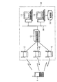
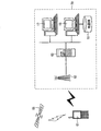
図1は本発明の第1の実施形態における位置情報システムの構成を示す図である。本実施形態では、PHS(登録商標)の移動体通信システムに適用した場合の無線携帯端末及び位置情報システムの構成例を示す。この位置情報システムは、PHS端末からなる無線携帯端末1および無線ネットワーク10を有して構成される。
(First embodiment)
FIG. 1 is a diagram showing a configuration of a position information system according to the first embodiment of the present invention. In the present embodiment, a configuration example of a wireless portable terminal and a position information system when applied to a PHS (registered trademark) mobile communication system is shown. This location information system includes a wireless
無線ネットワーク10は、無線携帯端末1と無線通信を行う複数の無線基地局12、無線携帯端末1および複数の無線基地局12間の無線通信を管理する無線制御装置13、およびネットワーク16を介して無線制御装置13と接続される複数のサーバ装置17、18を有して構成される。サーバ装置18は、地図データベース(DB)19を有し、無線携帯端末1の位置情報を基に、地図データベース19を検索し、検索された無線携帯端末付近の地図情報を、無線基地局12を通じて無線携帯端末1に配信する等の各種位置情報サービスを提供する。
The
無線携帯端末1は、周辺の無線基地局12から識別符号(CS−ID)を取得するとともに、無線基地局12からの送信信号の電界強度を測定し、これらの情報を無線携帯端末1の位置検出のための情報として無線基地局12に送信する。また、無線携帯端末1は、無線基地局12から受信した地図情報と自端末で測定した方位情報とを基に、目的地までの案内を表示する等の処理を行う。
The wireless
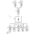
図2は第1の実施形態の無線携帯端末1の構成を示すブロック図である。無線携帯端末1は、全体の各部を制御する制御部26を中心に構成されている。制御部26には、アンテナ21を介して無線基地局12と無線信号を送受信する無線制御部22、各種情報が表示される表示部23、音声の入出力を行う音声入出力部24、各種キーの操作が行われる操作部25、地図情報等が記憶される画像メモリ31、および一対の地磁気センサ28、29のいずれかを選択する選択手段の一例に相当する選択回路27が接続されている。
FIG. 2 is a block diagram illustrating a configuration of the wireless
制御部26は、方位検出手段の機能を有しており、地磁気検出手段の一例に相当するする地磁気センサ28、29の出力に基づき、所定の演算を行うことによって無線携帯端末1の筐体が向いている方位を検出する。また、制御部26は、識別番号取得手段、電界強度検出手段、基地局情報送信手段の機能を有し、周囲の無線基地局の識別番号を取得するとともに無線基地局からの送信信号の電界強度を検出し、これらの識別番号および電界強度の情報を無線ネットワーク10に送信する。一方、無線ネットワーク10の無線制御装置13は、位置検出手段の機能を有し、無線携帯端末1から送信される無線基地局の識別番号および電界強度の情報に基づき、当該無線携帯端末1の位置を検出する。また、制御部26は、提供情報処理手段の機能を有し、前記検出された方位情報に応じて無線ネットワーク10より提供される地図情報等に対する各種処理を行い、表示部23への情報表示などを行う。
The
操作部25には、地磁気センサ28、29のいずれかを切り替えて選択するための選択操作部の一例に相当する選択キー25aと、位置情報サービスの終了を指示する終了キー25bとが設けられている。選択キー25aが1回押下される度に、地磁気センサ28、29の選択は交互に切り替えられる。具体的に、操作者によって選択キー25aが押下されると、制御部26から選択回路27に切替信号が出力され、選択回路27はこの切替信号の入力に応じて地磁気センサ28、29の選択を交互に切り替える。
The
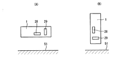
図3は無線携帯端末1内における地磁気センサ28、29の配置状態を示す図である。 本実施形態では、一対の地磁気センサ28、29は、互いに異なる向き、好ましくは互いに直交する向きに配置されている。すなわち、無線携帯端末1の筐体の長手方向には、地磁気センサ28が取り付けられており、これと直交する短手方向には、地磁気センサ29が取り付けられている。図3(A)は地面51に対して無線携帯端末1が横向き(水平方向)に位置する状態を示し、この場合、地磁気センサ28は地面51に対して略平行となり、地磁気センサ29は地面に対して略垂直となる。図3(B)は地面51に対して無線携帯端末1が縦向き(垂直方向)に位置する状態を示し、この場合、地磁気センサ28は地面に対して略垂直となり、地磁気センサ29は地面51に対して略平行となる。 なお、地磁気センサの数は、特に2つに限定されず、3つ以上であってもよい。また、本実施形態では、2つの地磁気センサが略直交するように設置されているが、無線携帯端末がどのような姿勢であっても、どちらかの地磁気センサで地磁気を検出可能である限り、2つの地磁気センサはどのような関係で設置されてもよい。
FIG. 3 is a diagram showing an arrangement state of the
この地磁気センサ28、29は、磁気抵抗素子(MR素子)とコイルからなる2組のユニットが互いに直交するX方向およびY方向に配置されたものであり、地磁気とコイル発生磁界の合成磁界を磁気抵抗素子で検出する。図4は地磁気センサの特性を示す図である。地磁気センサを地磁気に対してθだけ回転させた場合、2組のユニットから回転角に対応する出力信号Vx、Vyが出力される。出力信号Vx、Vyはそれぞれsin波およびcos波であり、回転角度θは次の数式(1)から求まり、方位を決定することができる。
θ=tan-1(Vx/Vy) …(1)
The
θ = tan −1 (Vx / Vy) (1)
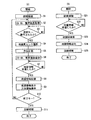
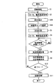
次に、上記構成を有する無線携帯端末および無線ネットワークからなる位置情報システムの動作を示す。図5は第1の実施形態における位置情報サービス実行時の無線携帯端末1および無線ネットワーク10の処理手順を示すフローチャートである。図5(A)は無線携帯端末側の処理を示し、図5(B)は無線ネットワーク側の処理を示す。
Next, an operation of the location information system including the wireless portable terminal and the wireless network having the above configuration will be described. FIG. 5 is a flowchart showing a processing procedure of the wireless
無線携帯端末側では、まず、周辺の無線基地局12と無線通信による回線の接続を行う(ステップS1)。回線が接続されると、無線基地局12から識別符号(CS−ID)を取得するとともに、無線基地局12からの送信信号の電界強度を測定する(ステップS2)。この後、操作者による選択キー25aの押下操作を検出する(ステップS3)。選択キー25aが押下されると、選択キー25aの押下(例えば各センサに対応する操作部の押下や押下回数)に応じて地磁気センサ28、29のいずれかを選択する(ステップS4)。そして、選択された地磁気センサを用いて方位を計測し、計測された方位情報をメモリ(図示せず)に記憶する(ステップS5)。
On the wireless portable terminal side, first, a line connection by wireless communication is performed with the surrounding wireless base station 12 (step S1). When the line is connected, an identification code (CS-ID) is acquired from the
そして、ステップS2で取得された識別符号(CS−ID)および測定された無線基地局12の電界強度を、無線携帯端末の位置情報として、無線基地局12に送信する(ステップS6)。この後、無線基地局12から地図情報を受信するまで待つ(ステップS7)。地図情報を受信すると、受信した地図情報を画像メモリ31に記憶する(ステップS8)。ステップS4で計測された方位情報を基に、画像メモリ31に記憶された地図情報を表示部23に表示する(ステップS9)。この方位情報に基づく地図情報の表示の詳細については後述する。この後、終了キー25bが押下され、位置情報サービスの終了が指示されたか否かを判別する(ステップS10)。終了キー25bが押下されていない場合、ステップS2に戻って同様の処理を繰り返す。一方、ステップS9で終了キー25bが押下された場合、回線を切断し(ステップS11)、本処理を終了する。
Then, the identification code (CS-ID) acquired in step S2 and the measured electric field strength of the
一方、無線ネットワーク側では、無線携帯端末側からの回線の接続要求を受けると、無線携帯端末と無線通信による回線の接続を行う(ステップS21)。そして、無線携帯端末1から識別符号(CS−ID)および電界強度を受信して位置情報の検出を行う(ステップS22)。位置情報が検出されると、その位置情報を基に、サーバ装置18は、地図データベース19を検索する(ステップS23)。そして、検索された地図情報を無線基地局12を介して無線携帯端末1に送信する(ステップS24)。この後、無線携帯端末側からの回線の切断要求を受けると、回線を切断し(ステップS25)、本処理を終了する。
On the other hand, on the wireless network side, when a line connection request is received from the wireless portable terminal side, the line is connected to the wireless portable terminal by wireless communication (step S21). Then, the identification information (CS-ID) and the electric field strength are received from the wireless
また、上記手順において、無線携帯端末1と無線ネットワーク10との間の回線の接続を維持した状態で、無線携帯端末の位置検出と方位の計測、地図情報の受信、地図および方位の表示を所定間隔で繰り返し実行し続けることによって、リアルタイムに位置情報を表示し、誘導案内等を行うことができる。
Further, in the above procedure, with the connection of the line between the wireless
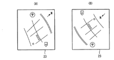
図6は検出した方位情報に基づいて表示部23において表示する地図情報の例を示す図である。図6(A)には、使用者が表示部23の画面を手前に向けて見ようと、無線携帯端末を保持する場合、方位情報に基づき、画面上部を進行方向とするように回転された地図情報が表示されている。また、図6(B)には、図6(A)の状態から、使用者が無線携帯端末とともに180度向きを反転させた場合、その方位情報に基づき、図6(A)の地図情報を180度回転させた地図情報が表示されている。なお、方位情報に基づき、表示部に表示される地図情報を回転させる代わりに、地図情報において無線携帯端末が向いている方位を矢印等で表示するようにしてもよい。
FIG. 6 is a diagram illustrating an example of map information displayed on the
このように、第1の実施形態によれば、使用者が無線携帯端末を保持する姿勢によらず、ユーザの操作によって選択される地磁気センサ28、29のいずれかによって方位を確実に検出できる。また、無線携帯端末で検出される方位情報に基づき、無線ネットワークから提供される地図情報を処理することができ、位置情報サービスを十分に活用できる。また、無線携帯端末と無線ネットワークとの間の回線の接続を維持した状態で、無線携帯端末の位置および方位の検出、これに対応する地図情報の表示を継続することによって、リアルタイムな誘導案内等を行うことが可能である。
Thus, according to the first embodiment, the orientation can be reliably detected by any one of the
(第2の実施形態)
第2の実施形態における無線携帯端末では、使用する地磁気センサを切り替える際、使用者が選択キーを操作することなく、無線携帯端末の傾きを検出して自動的に地磁気センサを切り替える場合を示す。
(Second Embodiment)
In the wireless portable terminal according to the second embodiment, when the geomagnetic sensor to be used is switched, the user detects the inclination of the wireless portable terminal and automatically switches the geomagnetic sensor without operating the selection key.
図7は本発明の第2の実施形態における無線携帯端末41の構成を示すブロック図である。前記第1の実施形態と同一の構成要素については同一の符号を付すことにより、その説明を省略する。すなわち、第2の実施形態では、制御部26には、傾き検出手段の一例に相当する傾き検出スイッチ32が設けられている。また、操作部25には、地磁気センサ28、29を切り替えるための選択キー25aが設けられない構成となっている。
FIG. 7 is a block diagram showing a configuration of the wireless portable terminal 41 in the second embodiment of the present invention. The same components as those in the first embodiment are denoted by the same reference numerals, and the description thereof is omitted. That is, in the second embodiment, the
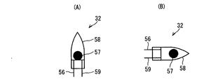
図8は傾き検出スイッチ32の構成の一例を示す図である。この傾き検出スイッチ32は、水銀スイッチからなり、ガラス管58、このガラス管58内にその先端が突出するように固着された一対の端子56、59、およびガラス管58内に移動自在に封入された水銀球57を有して構成される。
FIG. 8 is a diagram illustrating an example of the configuration of the
傾き検出スイッチ32は、無線携帯端末41内に設置されており、例えば、無線携帯端末41を縦方向に持つことで、水銀スイッチ32が地面に対して略垂直位置になるように配置されている場合、図8(A)に示すように、水銀球57は一対の端子56、59に接触し、水銀球57を介して一対の端子56、59は導通し、水銀スイッチ32はオンとなる。また、無線携帯端末41を横方向に持つことで、水銀スイッチ32が地面に対して略水平位置になるように配置されている場合、水銀球57は一対の端子56、59から離れ、一対の端子56、59は非導通となり、水銀スイッチ32はオフとなる。制御部26は、水銀スイッチ32のオン、オフ状態を検出することによって無線携帯端末41の傾き、すなわち使用者による保持状態を判別し、地磁気センサ28、29のいずれかに切り替える。傾き検出手段としては、水銀スイッチに限定されるものではなく、ジャイロ、電解式あるいは熱式のものなど、特に限定されない。
The
図9は第2の実施形態における位置情報サービス実行時の無線携帯端末側の処理手順を示すフローチャートである。前記第1の実施形態の図5(A)における同一のステップ処理については同一のステップ番号を付すことにより、その説明を省略する。なお、無線ネットワーク側の処理については、前記第1の実施形態と同じである。 FIG. 9 is a flowchart showing a processing procedure on the wireless portable terminal side when the location information service is executed in the second embodiment. The same step process in FIG. 5A of the first embodiment is denoted by the same step number, and the description thereof is omitted. Note that the processing on the wireless network side is the same as that in the first embodiment.
第2の実施形態では、ステップS2において、無線基地局12から識別符号(CS−ID)を取得するとともに、無線基地局12の電界強度を測定した後、制御部26は傾き検出スイッチ(水銀スイッチ)32のオン、オフ状態を検出し、保持されている無線携帯端末41の傾きを検出する(ステップS3A)。例えば、水銀スイッチ32がオン状態で無線携帯端末41が地面51に対して略垂直方向の姿勢にある場合、地磁気センサ29を選択し、一方、水銀スイッチ32がオフ状態で無線携帯端末41が地面51に対して略水平方向の姿勢にある場合、地磁気センサ28を選択する(ステップS4A)。そして、地磁気センサを用いて、前記第1の実施形態と同様の位置情報サービスを行う。
In the second embodiment, after acquiring the identification code (CS-ID) from the
このように、第2の実施形態によれば、無線携帯端末を保持する姿勢によらず、使用者が特別な操作を行うことなく自動的に最適な地磁気センサを選択して方位を検出することが可能である。 As described above, according to the second embodiment, the user can automatically select the optimum geomagnetic sensor and detect the orientation without performing a special operation regardless of the posture of holding the wireless portable terminal. Is possible.
(第3の実施形態)
図10は本発明の第3の実施形態における位置情報システムの構成を示す図である。第3の実施形態では、W−CDMA方式等の携帯電話の移動体通信システムに適用した場合の無線携帯端末及び位置情報システムの構成例を示す。前記第1、第2の実施形態では、無線携帯端末の位置情報として、周囲の無線基地局の識別符号(CS−ID)およびその電界強度を無線基地局に送信し、位置検出を行う構成としていたが、第3の実施形態では、GPS機能を有する無線携帯端末によって自端末の位置を検出するようになっている。
(Third embodiment)
FIG. 10 is a diagram showing a configuration of a position information system in the third embodiment of the present invention. In the third embodiment, a configuration example of a wireless portable terminal and a position information system when applied to a mobile communication system of a mobile phone such as a W-CDMA system is shown. In the first and second embodiments, as the position information of the wireless portable terminal, the identification code (CS-ID) of the surrounding wireless base station and the electric field strength thereof are transmitted to the wireless base station to perform position detection. However, in the third embodiment, the position of the own terminal is detected by a wireless portable terminal having a GPS function.
無線携帯端末61は、GPS機能を搭載しており、GPS衛星65からの電波をGPS受信部72で受信することにより、自端末の位置を測定する。無線ネットワーク70には、広範囲の通信エリアを有する無線基地局62の他、前記第1の実施形態と同様、無線制御装置63、サーバ装置17、18および地図データベース19等が設けられている。
The wireless
図11は第3の実施形態の無線携帯端末61の構成を示すブロック図である。この無線携帯端末61では、制御部26にGPS衛星65からの電波を受信するGPS受信部72が接続されている。その他の構成は前記第1の実施形態と同じであり、同一の構成要素には同一の符号を付している。無線携帯端末61は、GPS受信部72および制御部26によってGPS位置検出手段の機能を実現する構成となっており、GPS受信部72により受信したGPS衛星65からの電波を利用し、制御部26において緯度、経度等の位置情報を測定する。
FIG. 11 is a block diagram illustrating a configuration of the wireless
また、制御部26は、位置情報送信手段の機能を有し、前記検出した自端末の位置情報を無線ネットワーク10に送信する。一方、無線ネットワーク70の無線制御装置63は、無線携帯端末61から送信される端末の位置情報に基づき、現在位置に対応する地図情報等を当該無線携帯端末61に送信する。
Further, the
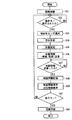
図12は第3の実施形態における位置情報サービス実行時の無線携帯端末側の処理手順を示すフローチャートである。なお、無線ネットワーク側の処理については、前記第1の実施形態と同じである。まず、無線基地局62と無線通信による回線の接続を行う(ステップS31)。回線が接続されると、操作者による選択キー25aの押下操作を検出する(ステップS32)。選択キー25aが押下されると、選択キー25aの押下(例えば各センサに対応する操作部の押下や押下回数)に応じて地磁気センサ28、29のいずれかを選択する(ステップS33)。そして、選択された地磁気センサを用いて方位を計測し、計測された方位情報をメモリ(図示せず)に記憶する(ステップS34)。
FIG. 12 is a flowchart showing a processing procedure on the wireless portable terminal side when the location information service is executed in the third embodiment. Note that the processing on the wireless network side is the same as that in the first embodiment. First, the wireless base station 62 is connected to a line by wireless communication (step S31). When the line is connected, a pressing operation of the selection key 25a by the operator is detected (step S32). When the selection key 25a is pressed, one of the
さらに、GPS受信部72により受信したGPS衛星65からの電波を利用し、緯度、経度等の位置情報を測定する(ステップS35)。そして、測定された緯度、経度等の位置情報を無線基地局62に送信する(ステップS36)。
Further, position information such as latitude and longitude is measured using the radio wave from the
この後、無線基地局62から地図情報を受信するまで待つ(ステップS37)。地図情報を受信すると、受信した地図情報を画像メモリ31に記憶する(ステップS38)。ステップS34で計測された方位情報を基に、画像メモリ31に記憶された地図情報を表示部23に表示する(ステップS39)。この方位情報に基づく地図情報の表示は、前記第1の実施形態と同じである。この後、終了キー25bが押下され、位置情報サービスの終了が指示されたか否かを判別する(ステップS40)。終了キー25bが押下されていない場合、ステップS32に戻って同様の処理を繰り返す。一方、ステップS40で終了キー25bが押下された場合、回線を切断し(ステップS41)、本処理を終了する。
Then, it waits until map information is received from the wireless base station 62 (step S37). When the map information is received, the received map information is stored in the image memory 31 (step S38). Based on the azimuth information measured in step S34, the map information stored in the
また、上記手順において、無線携帯端末61と無線ネットワーク70との間の回線の接続を維持した状態で、無線携帯端末の位置検出と方位の計測、地図情報の受信、地図および方位の表示を所定間隔で繰り返し実行し続けることによって、リアルタイムに位置情報を表示し、誘導案内等を行うことができる。
Further, in the above procedure, with the connection of the line between the wireless
このように、第3の実施形態によれば、GPS機能を搭載した無線携帯端末を用いた場合にも、無線携帯端末を保持する姿勢によらず、自端末の位置および方位を確実に検出でき、前記第1の実施形態と同様の位置情報サービスを受けることができる。なお、前記第2の実施形態と同様、無線携帯端末内に傾き検出スイッチを設け、自動的に地磁気センサを選択して方位検出を行うような構成でもよいことは勿論である。 Thus, according to the third embodiment, even when a wireless portable terminal equipped with a GPS function is used, the position and orientation of the terminal itself can be reliably detected regardless of the attitude of holding the wireless portable terminal. The location information service similar to that of the first embodiment can be received. Of course, as in the second embodiment, a tilt detection switch may be provided in the wireless portable terminal, and a configuration in which the geomagnetic sensor is automatically selected to detect the direction may be used.
(第4の実施形態)
前記第1の実施形態では、計測された方位情報に基づき、無線携帯端末側で地図情報を処理していたが、第4の実施形態では、無線携帯端末から方位情報を無線ネットワーク側に送信し、無線ネットワーク側では、受信した方位情報を基に、地図情報を処理して無線携帯端末に送信する場合を示す。無線携帯端末および無線ネットワークの構成については、前記第1の実施形態と同様であるので、同一の符号を用いることによりその説明を省略する。
(Fourth embodiment)
In the first embodiment, the map information is processed on the wireless portable terminal side based on the measured azimuth information. In the fourth embodiment, the directional information is transmitted from the wireless portable terminal to the wireless network side. On the wireless network side, the map information is processed based on the received direction information and transmitted to the wireless portable terminal. Since the configuration of the wireless portable terminal and the wireless network is the same as that of the first embodiment, description thereof is omitted by using the same reference numerals.
この第4の実施形態において、制御部26は、方位情報送信手段の機能を有し、自端末で検出した方位情報を無線制御部22、アンテナ21を介して無線ネットワーク10に送信する。一方、無線ネットワーク10の無線制御装置13は、無線携帯端末1から送信される端末の方位情報に応じて提供する地図情報等に対する各種処理を行った後、無線携帯端末1に送信する。
In the fourth embodiment, the
図13は第4の実施形態における位置情報サービス実行時の無線携帯端末1および無線ネットワーク10の処理手順を示すフローチャートである。図13(A)は無線携帯端末側の処理を示し、図13(B)は無線ネットワーク側の処理を示す。前記第1の実施形態と同一のステップ処理については、同一のステップ番号を付すことによりその説明を省略する。
FIG. 13 is a flowchart showing a processing procedure of the wireless
無線携帯端末側では、ステップS5において、選択された地磁気センサを用いて方位が計測されると、ステップS2で取得された識別符号(CS−ID)および測定された無線基地局12の電界強度を無線基地局12に送信するとともに、ステップS5で計測された方位情報も併せて無線基地局12に送信する(ステップS6A)。そして、無線基地局12から地図情報を受信するまで待つ(ステップS7)。地図情報を受信すると、受信した地図情報を画像メモリ31に記憶する(ステップS8)。この地図情報は、無線ネットワーク側で方位情報に基づく地図の回転や方位指示等の処理が行われたものである。そして、画像メモリ31に記憶された方位処理済みの地図情報を表示部23に表示する(ステップS9A)。
On the wireless portable terminal side, when the azimuth is measured using the selected geomagnetic sensor in step S5, the identification code (CS-ID) acquired in step S2 and the measured electric field strength of the
一方、無線ネットワーク側では、ステップS21で回線が接続されると、無線携帯端末から識別符号(CS−ID)および電界強度を受信して位置情報の検出を行うとともに、方位情報を受信する(ステップS22A)。そして、サーバ装置18が位置情報に基づいて地図データベース19を検索し(ステップS23)、検索された地図情報に対し、方位情報に基づく処理を行う(ステップS23A)。この方位情報に基づく処理としては、例えば、前述したように、表示部に表示される地図情報を回転させたり、地図上に無線携帯端末の向いている方位を矢印等で表示する処理が挙げられる。そして、処理された地図情報は、ステップS24で無線携帯端末1に送信される。
On the other hand, on the wireless network side, when the line is connected in step S21, the identification code (CS-ID) and the electric field strength are received from the wireless portable terminal to detect the position information and also receive the direction information (step). S22A). And the
このように、第4の実施形態によれば、方位情報に基づいて地図情報を処理する際、無線携帯端末側の負荷を軽減できる。なお、第4の実施形態では、前記第1の実施形態と同様のシステム構成に適用された場合を示したが、第2、第3の実施形態と同様のシステム構成に適用してもよいことは勿論である。 Thus, according to the fourth embodiment, the load on the wireless portable terminal can be reduced when the map information is processed based on the direction information. In the fourth embodiment, the case where the present invention is applied to the system configuration similar to that of the first embodiment has been described. However, the fourth embodiment may be applied to the same system configuration as that of the second and third embodiments. Of course.
以上が本発明の実施の形態の説明であるが、本発明は、上記実施形態の構成に限られるものではなく、他のシステム構成に適用したりなど、種々の変形が可能である。例えば、上記実施形態では、位置情報サービスとして、無線携帯端末に地図情報を配信する場合を示したが、現在地の確認、車両・営業・保守などの位置管理システム、または自分自身のナビゲーションシステムなどであってもよい。また、上記実施形態では、無線携帯端末として、PHS端末、携帯電話端末を用いた場合を示したが、この他、無線通信機能を有するPDA(携帯情報端末)、ノート型PC等に適用してもよいことは勿論である。 The above is the description of the embodiment of the present invention. However, the present invention is not limited to the configuration of the above embodiment, and various modifications such as application to other system configurations are possible. For example, in the above embodiment, the case where map information is distributed to a wireless portable terminal as a location information service has been shown. However, the location management system such as confirmation of the current location, vehicle / sales / maintenance, or own navigation system can be used. There may be. In the above embodiment, the case where a PHS terminal or a mobile phone terminal is used as the wireless mobile terminal is shown. However, the present invention is applied to a PDA (personal digital assistant) having a wireless communication function, a notebook PC, or the like. Of course, it is also good.
本発明は、無線携帯端末を保持する姿勢によらず、確実に方位を検出できるという効果、および、無線携帯端末で検出される方位情報に基づき、無線ネットワークから提供される位置情報サービスを十分に活用できるという効果を有し、位置情報を取得する無線携帯端末、及びこの無線携帯端末の位置情報に基づいて位置情報サービスを提供する位置情報システム等に有用である。 The present invention sufficiently provides a position information service provided from a wireless network based on the effect that the direction can be reliably detected regardless of the attitude of holding the wireless portable terminal and the direction information detected by the wireless portable terminal. It has the effect that it can be used, and is useful for a wireless portable terminal that acquires position information, a position information system that provides a position information service based on the position information of the wireless portable terminal, and the like.
1、41、61 無線携帯端末
10、70 無線ネットワーク
12、62 無線基地局
13、63 無線制御装置
17、18 サーバ装置
19 地図データベース
23 表示部
25 操作部
25a 選択キー
26 制御部
27 選択回路
28、29 地磁気センサ
32 傾き検出スイッチ
72 GPS受信部
DESCRIPTION OF
Claims (9)
前記複数の地磁気検出手段のいずれかを選択する選択手段と、
前記選択された地磁気検出手段からの出力信号を基に、自端末が向いている方位を検出する方位検出手段と、
を備える無線携帯端末。 A plurality of geomagnetism detecting means arranged in different directions in the housing and detecting geomagnetism respectively;
Selecting means for selecting any of the plurality of geomagnetism detecting means;
Based on the output signal from the selected geomagnetic detection means, the direction detection means for detecting the direction in which the terminal is facing;
A wireless portable terminal comprising:
選択指示操作入力を行う選択操作部を備え、
前記選択手段は、前記選択操作部の操作入力に従って前記複数の地磁気検出手段のいずれかを選択する無線携帯端末。 The wireless mobile terminal according to claim 1,
A selection operation unit for performing selection instruction operation input is provided.
The selection means is a wireless portable terminal that selects one of the plurality of geomagnetism detection means in accordance with an operation input of the selection operation unit.
前記無線携帯端末の筐体の傾きを検出する傾き検出手段を備え、
前記選択手段は、前記傾き検出手段の出力に基づいて前記複数の地磁気検出手段のいずれかを選択する無線携帯端末。 The wireless mobile terminal according to claim 1,
Inclination detecting means for detecting the inclination of the housing of the wireless portable terminal,
The selection means is a wireless portable terminal that selects one of the plurality of geomagnetism detection means based on the output of the inclination detection means.
前記無線携帯端末は、
筐体内に互いに異なる向きに配置され、それぞれ地磁気を検出する複数の地磁気検出手段と、
前記複数の地磁気検出手段のいずれかを選択する選択手段と、
前記選択された地磁気検出手段からの出力信号を基に、自端末が向いている方位を検出する方位検出手段と、
前記検出された方位情報に基づき、前記提供された位置情報サービスの内容を処理する提供情報処理手段と、
を備える位置情報システム。 A position information system comprising a wireless portable terminal and a wireless network connected to the wireless portable terminal, and providing a position information service from the server of the wireless network to the wireless portable terminal based on the position information of the wireless portable terminal. ,
The wireless portable terminal is:
A plurality of geomagnetism detecting means arranged in different directions in the housing and detecting geomagnetism respectively;
Selecting means for selecting any of the plurality of geomagnetism detecting means;
Based on the output signal from the selected geomagnetic detection means, the direction detection means for detecting the direction in which the terminal is facing;
Provided information processing means for processing the content of the provided location information service based on the detected azimuth information;
A location information system comprising:
前記無線携帯端末は、
筐体内に互いに異なる向きに配置され、それぞれ地磁気を検出する複数の地磁気検出手段と、
前記複数の地磁気検出手段のいずれかを選択する選択手段と、
前記選択された地磁気検出手段からの出力信号を基に、自端末が向いている方位を検出する方位検出手段と、
前記検出された方位情報を前記無線ネットワークに送信する方位情報送信手段と、
を備える位置情報システム。 A position information system comprising a wireless portable terminal and a wireless network connected to the wireless portable terminal, and providing a position information service from the server of the wireless network to the wireless portable terminal based on the position information of the wireless portable terminal. ,
The wireless portable terminal is:
A plurality of geomagnetism detecting means arranged in different directions in the housing and detecting geomagnetism respectively;
Selecting means for selecting any of the plurality of geomagnetism detecting means;
Based on the output signal from the selected geomagnetic detection means, the direction detection means for detecting the direction in which the terminal is facing;
Azimuth information transmitting means for transmitting the detected azimuth information to the wireless network;
A location information system comprising:
前記無線携帯端末は、
自端末周辺の無線基地局の識別番号を取得する識別番号取得手段と、
前記無線基地局からの送信信号の電界強度を検出する電界強度検出手段と、
前記無線基地局の識別番号および電界強度を前記無線ネットワークに送信する基地局情報送信手段とを備え、
前記無線ネットワークは、
前記無線携帯端末より取得した無線基地局の識別番号および電界強度を基に、前記無線携帯端末の位置を検出する位置検出手段を備え、前記検出された位置情報に基づいて前記位置情報サービスを提供する位置情報システム。 The position information system according to claim 4 or 5,
The wireless portable terminal is:
Identification number acquisition means for acquiring identification numbers of wireless base stations around the terminal,
Electric field strength detecting means for detecting the electric field strength of the transmission signal from the radio base station;
Base station information transmitting means for transmitting the identification number and electric field strength of the wireless base station to the wireless network,
The wireless network is
Provided with position detecting means for detecting the position of the wireless portable terminal based on the identification number and electric field strength of the wireless base station acquired from the wireless portable terminal, and providing the position information service based on the detected position information Location information system.
前記無線携帯端末は、
GPSからの信号を受信して自端末の位置を検出するGPS位置検出手段と、
前記検出された位置情報を前記無線ネットワークに送信する位置情報送信手段とを備え、
前記無線ネットワークは、
前記無線携帯端末より取得した位置情報に基づいて前記位置情報サービスを提供する位置情報システム。 The position information system according to claim 4 or 5,
The wireless portable terminal is:
GPS position detecting means for receiving a signal from GPS and detecting the position of the terminal itself;
Position information transmitting means for transmitting the detected position information to the wireless network,
The wireless network is
A location information system that provides the location information service based on location information acquired from the wireless portable terminal.
前記無線ネットワークは、所定間隔ごとに検出される前記無線携帯端末の位置に応じて繰り返し前記位置情報サービスを提供する位置情報システム。 The position information system according to any one of claims 4 to 7,
The position information system in which the wireless network repeatedly provides the position information service according to the position of the wireless portable terminal detected at predetermined intervals.
前記無線ネットワークは、前記無線携帯端末から送信された方位情報に対応した位置情報サービスを提供する位置情報システム。 The position information system according to any one of claims 6 to 8,
The wireless network is a positional information system that provides a positional information service corresponding to azimuth information transmitted from the wireless portable terminal.
Priority Applications (1)
| Application Number | Priority Date | Filing Date | Title |
|---|---|---|---|
| JP2004103062A JP2005294931A (en) | 2004-03-31 | 2004-03-31 | Wireless portable terminal and position information system |
Applications Claiming Priority (1)
| Application Number | Priority Date | Filing Date | Title |
|---|---|---|---|
| JP2004103062A JP2005294931A (en) | 2004-03-31 | 2004-03-31 | Wireless portable terminal and position information system |
Publications (1)
| Publication Number | Publication Date |
|---|---|
| JP2005294931A true JP2005294931A (en) | 2005-10-20 |
Family
ID=35327426
Family Applications (1)
| Application Number | Title | Priority Date | Filing Date |
|---|---|---|---|
| JP2004103062A Withdrawn JP2005294931A (en) | 2004-03-31 | 2004-03-31 | Wireless portable terminal and position information system |
Country Status (1)
| Country | Link |
|---|---|
| JP (1) | JP2005294931A (en) |
Cited By (4)
| Publication number | Priority date | Publication date | Assignee | Title |
|---|---|---|---|---|
| JP2007010614A (en) * | 2005-07-04 | 2007-01-18 | Casio Hitachi Mobile Communications Co Ltd | Direction measuring apparatus with wireless communication function and direction measuring method |
| JP2009111928A (en) * | 2007-10-31 | 2009-05-21 | Sharp Corp | Portable terminal device and control method thereof, portable terminal device control program, and computer-readable recording medium |
| JP2014087017A (en) * | 2012-10-26 | 2014-05-12 | Fujitsu Ltd | Positioning device, mobile station, and positioning method |
| JP2016095310A (en) * | 2015-12-04 | 2016-05-26 | リコーイメージング株式会社 | Direction measuring method and direction measuring apparatus |
-
2004
- 2004-03-31 JP JP2004103062A patent/JP2005294931A/en not_active Withdrawn
Cited By (4)
| Publication number | Priority date | Publication date | Assignee | Title |
|---|---|---|---|---|
| JP2007010614A (en) * | 2005-07-04 | 2007-01-18 | Casio Hitachi Mobile Communications Co Ltd | Direction measuring apparatus with wireless communication function and direction measuring method |
| JP2009111928A (en) * | 2007-10-31 | 2009-05-21 | Sharp Corp | Portable terminal device and control method thereof, portable terminal device control program, and computer-readable recording medium |
| JP2014087017A (en) * | 2012-10-26 | 2014-05-12 | Fujitsu Ltd | Positioning device, mobile station, and positioning method |
| JP2016095310A (en) * | 2015-12-04 | 2016-05-26 | リコーイメージング株式会社 | Direction measuring method and direction measuring apparatus |
Similar Documents
| Publication | Publication Date | Title |
|---|---|---|
| JP5039379B2 (en) | Handheld object selection device | |
| KR100424462B1 (en) | Apparatus for displaying position information and direction in portable terminal and method same | |
| US20030084119A1 (en) | Position information processing terminal and position information supply system, and position information processing method | |
| JPH09182143A (en) | Terminal equipment | |
| KR20130068316A (en) | Device and method for displaying a position of mobile terminal | |
| KR100802052B1 (en) | How to get directions to a target with a handset | |
| JP3125771B2 (en) | Method and system for providing terminal peripheral information | |
| JP4620054B2 (en) | Portable terminal and wireless quality display method, program and system using the same | |
| KR100754690B1 (en) | Method and apparatus for setting a destination of a navigation terminal | |
| JP2005294931A (en) | Wireless portable terminal and position information system | |
| JP2004061187A (en) | Navigation method, navigation system, navigation terminal device, and location registration server | |
| JP2003194571A (en) | Portable terminal | |
| KR100516900B1 (en) | Mobile Phone and Location Information Providing System Using a Magnetic sensor/Local Based Service | |
| JP2003287426A (en) | GPS positioning device and position information display method | |
| KR100741700B1 (en) | System and method for detecting Location of Mobile station | |
| JP2004028854A (en) | Portable terminal, positional information server, and user guiding system | |
| KR100606762B1 (en) | Apparatus and method for displaying the direction of the other party's location using mobile terminal | |
| JP2001041765A (en) | Destination guide system | |
| KR100640484B1 (en) | Apparatus and method for providing location information between mobile communication terminals | |
| JP2004340854A (en) | Map information distribution system | |
| JP2002031541A (en) | Portable telephone terminal for pedestrian navigation | |
| JP2004028642A (en) | Position detection display method and position detection communication system and program of group detection object radio terminal | |
| JP2004040427A (en) | Portable mobile apparatus and position information notice method used for the same | |
| JP5389336B2 (en) | Mobile terminal and program for displaying a schematic map of the current position in advance on the display | |
| KR100684171B1 (en) | Location information service system and method using a mobile phone |
Legal Events
| Date | Code | Title | Description |
|---|---|---|---|
| RD04 | Notification of resignation of power of attorney |
Free format text: JAPANESE INTERMEDIATE CODE: A7424 Effective date: 20060327 |
|
| A621 | Written request for application examination |
Free format text: JAPANESE INTERMEDIATE CODE: A621 Effective date: 20070131 |
|
| RD02 | Notification of acceptance of power of attorney |
Free format text: JAPANESE INTERMEDIATE CODE: A7422 Effective date: 20071114 |
|
| RD04 | Notification of resignation of power of attorney |
Free format text: JAPANESE INTERMEDIATE CODE: A7424 Effective date: 20071121 |
|
| RD02 | Notification of acceptance of power of attorney |
Free format text: JAPANESE INTERMEDIATE CODE: A7422 Effective date: 20071128 |
|
| RD04 | Notification of resignation of power of attorney |
Free format text: JAPANESE INTERMEDIATE CODE: A7424 Effective date: 20071205 |
|
| RD04 | Notification of resignation of power of attorney |
Free format text: JAPANESE INTERMEDIATE CODE: A7424 Effective date: 20071212 |
|
| A761 | Written withdrawal of application |
Free format text: JAPANESE INTERMEDIATE CODE: A761 Effective date: 20080904 |