JP2005294893A - Image distribution system - Google Patents
Image distribution system Download PDFInfo
- Publication number
- JP2005294893A JP2005294893A JP2004102479A JP2004102479A JP2005294893A JP 2005294893 A JP2005294893 A JP 2005294893A JP 2004102479 A JP2004102479 A JP 2004102479A JP 2004102479 A JP2004102479 A JP 2004102479A JP 2005294893 A JP2005294893 A JP 2005294893A
- Authority
- JP
- Japan
- Prior art keywords
- image
- server
- image file
- transmitted
- information
- Prior art date
- Legal status (The legal status is an assumption and is not a legal conclusion. Google has not performed a legal analysis and makes no representation as to the accuracy of the status listed.)
- Pending
Links
Images


Landscapes
- Navigation (AREA)
- Information Transfer Between Computers (AREA)
- Two-Way Televisions, Distribution Of Moving Picture Or The Like (AREA)
- Traffic Control Systems (AREA)
- Mobile Radio Communication Systems (AREA)
Abstract
【課題】目的地までのルート上に存在する画像を容易かつタイムリーに配信可能なシステムの実現。
【解決手段】撮影機能及びGPS機能を備えたユーザの携帯電話14から送信された画像ファイル及び位置情報を、サーバ12の記憶部36に多数格納しておく。携帯電話14からルート探索要求が送信されると、サーバ12のルート探索部34が最適ルートを算出し、画像情報抽出部32がルート上に配置された画像ファイルを抽出し、その位置情報を携帯電話14に送信する。携帯電話14は、現在位置が画像位置に近づくと、サーバ12に対して該当の画像ファイルの配信を要求する。サーバ12から画像ファイルが送信されると、携帯電話14のディスプレイ26に表示される。
【選択図】 図1
To realize a system capable of easily and timely distributing an image existing on a route to a destination.
A large number of image files and position information transmitted from a mobile phone 14 of a user having a photographing function and a GPS function are stored in a storage unit 36 of a server 12. When a route search request is transmitted from the mobile phone 14, the route search unit 34 of the server 12 calculates the optimum route, the image information extraction unit 32 extracts the image file arranged on the route, and the position information is carried by the mobile phone. Send to phone 14. When the current position approaches the image position, the mobile phone 14 requests the server 12 to distribute the corresponding image file. When the image file is transmitted from the server 12, it is displayed on the display 26 of the mobile phone 14.
[Selection] Figure 1
Description
この発明は画像配信技術に係り、特に、位置情報を付与された風景画像をサーバ側に多数蓄積しておき、出発地と目的地間を結ぶルート上を移動する携帯端末に対し、同ルート上に配置された画像をタイムリーに配信するシステムに関する。 The present invention relates to an image distribution technique, and in particular, a large number of landscape images to which position information is assigned are stored on the server side, and a portable terminal moving on a route connecting a starting point and a destination is provided on the route. The present invention relates to a system for delivering images arranged in a timely manner.
近時、GPS(Global Positioning System)機能を搭載した携帯電話が普及してきており、非特許文献1に示す通り、カーナビゲーションシステムのように目的地までの最適ルートに沿って地図や音声でユーザを案内するサービスが登場している。
また、特許文献1及び2に示すように、ディジタルカメラ機能及びGPS機能を備えた携帯電話を用いて撮影した画像を、位置情報(緯度・経度)と共に送信してセンターに蓄積しておき、その存在を示すシンボルを地図上で表示することにより、他のユーザからの要求に応じて当該画像を携帯電話に配信するシステムも提案されている。
In addition, as shown in Patent Documents 1 and 2, an image taken using a mobile phone having a digital camera function and a GPS function is transmitted together with position information (latitude / longitude) and stored in the center. There has also been proposed a system in which a symbol indicating the presence is displayed on a map to deliver the image to a mobile phone in response to a request from another user.
確かに、非特許文献1に示すようなナビゲーションシステムにより、ユーザを出発地から目的地まで案内することができる。
しかしながら、従来のナビゲーションシステムの場合、携帯電話の狭い画面に道路や建物の図形あるいは文字が凝縮表示されるため極めて視認性が悪く、目的地に到達するまでのルートをイメージしにくいという問題があった。具体的には、眼前の風景と画面上の地図とが結び付かず、正しい道を歩いているのか不安になる場合が少なくない。
また、特許文献1または2の技術によれば、特定のポイントを指定してその場所の画像を入手することはできるが、目的地までのルート上に存在する画像を個別に指定して配信を受けるのは煩雑過ぎる。
Certainly, the navigation system as shown in Non-Patent Document 1 can guide the user from the departure place to the destination.
However, with conventional navigation systems, roads, buildings, and characters are condensed and displayed on a narrow screen of a mobile phone, so the visibility is extremely poor and it is difficult to imagine the route to reach the destination. It was. Specifically, there are many cases where the scenery in front of the eyes and the map on the screen are not linked, and it is anxious whether the person is walking on the right road.
Further, according to the technique of Patent Document 1 or 2, it is possible to specify a specific point and obtain an image of the place, but specify an image existing on the route to the destination individually for distribution. It is too complicated to receive.
この発明は、上記した従来の問題点を解決するためになされたものであり、ユーザに対して目的地までのルート上に存在する画像を容易かつタイムリーに配信することができるシステムの実現を目的としている。 The present invention has been made to solve the above-described conventional problems, and realizes a system capable of easily and timely distributing an image existing on a route to a destination to a user. It is aimed.
上記の目的を達成するため、請求項1に記載した画像配信システムは、ユーザの操作する携帯端末と、無線通信網を含むネットワークを介して携帯端末と接続されるサーバとからなる画像配信システムであって、上記携帯端末が、画像を撮影する手段と、携帯端末の位置情報を取得する手段と、ディスプレイと、入力手段と、撮影した画像ファイル及びその位置情報をサーバに送信する手段と、ディスプレイ上に出発地及び目的地を入力するための画面を表示させる手段と、入力された出発地及び目的地をサーバに送信し、出発地及び目的地間を結ぶルート上に配置された画像の検索を要求する手段と、サーバから送信された画像の位置情報を保存する記憶手段と、現在位置情報と各画像の位置情報とを比較し、両者が所定距離内に近づいた場合に上記サーバに対して当該画像の配信を要求する手段と、サーバから配信された画像を上記ディスプレイ上に表示させる手段とを備え、上記サーバが、携帯端末から送信された画像ファイルを位置情報に関連付けて記憶手段に格納する手段と、携帯端末から送信された出発地及び目的地間を結ぶルートを探索する手段と、当該ルートに対して所定距離内に位置する画像を抽出する手段と、各画像の位置情報を携帯端末に送信する手段と、携帯端末から特定位置における画像の配信要求が送信された場合に、該当の画像ファイルを抽出して携帯端末に配信する手段とを備えたことを特徴としている。
また、請求項2に記載した画像配信システムは、無線通信網を含むネットワークを介してユーザの操作する携帯端末と接続されるサーバを備えた画像配信システムであって、上記サーバが、上記携帯端末から画像ファイル及びその位置情報が送信された場合に、当該画像ファイルを位置情報に関連付けて記憶手段に格納する手段と、上記携帯端末から出発地及び目的地を特定する情報が送信された場合に、当該出発地及び目的地間を結ぶルートを探索する手段と、当該ルートに対して所定距離内に位置する画像を抽出する手段と、各画像の位置情報を携帯端末に送信する手段と、携帯端末から特定位置における画像の配信要求が送信された場合に、該当の画像ファイルを抽出して携帯端末に配信する手段とを備えたことを特徴としている。
In order to achieve the above object, an image distribution system according to claim 1 is an image distribution system including a mobile terminal operated by a user and a server connected to the mobile terminal via a network including a wireless communication network. The portable terminal captures an image, a means for acquiring position information of the portable terminal, a display, an input means, a means for transmitting the captured image file and its position information to a server, and a display. A means for displaying a screen for inputting a departure point and a destination on the top, and transmitting the input departure point and destination to the server, and searching for an image arranged on a route connecting the departure point and the destination. And the storage means for storing the position information of the image transmitted from the server, the current position information and the position information of each image are compared, and both are within a predetermined distance. A means for requesting the server to distribute the image, and a means for displaying the image distributed from the server on the display, wherein the server receives the position information of the image file transmitted from the portable terminal. Means for storing in association with the storage means, means for searching for a route connecting the departure point and the destination transmitted from the mobile terminal, means for extracting an image located within a predetermined distance with respect to the route, Means for transmitting the position information of each image to the mobile terminal, and means for extracting the image file and distributing it to the mobile terminal when an image distribution request at a specific position is transmitted from the mobile terminal It is characterized by.
The image distribution system according to claim 2 is an image distribution system including a server connected to a portable terminal operated by a user via a network including a wireless communication network, wherein the server is the portable terminal. When the image file and its position information are transmitted from the device, the image file is associated with the position information and stored in the storage means, and the mobile terminal transmits information specifying the departure place and the destination. Means for searching for a route connecting the starting point and the destination, means for extracting an image located within a predetermined distance with respect to the route, means for transmitting position information of each image to the portable terminal, And a means for extracting a corresponding image file and distributing it to a portable terminal when a request for distribution of an image at a specific position is transmitted from the terminal.
この画像配信システムによれば、出発地から目的地に至るルート上に存在する画像ファイルが、ユーザの移動に伴って自動的に携帯端末に配信され、ディスプレイ上に表示されることとなるため、ユーザは目の前の風景と当該画像を見比べることによって道が正しいことを直感的に認識することが可能となる。 According to this image delivery system, an image file existing on the route from the departure place to the destination is automatically delivered to the mobile terminal as the user moves, and is displayed on the display. The user can intuitively recognize that the road is correct by comparing the image in front of the eyes with the image.
請求項3に記載の画像配信システムは、請求項1または2のシステムを前提とし、さらに上記サーバが、携帯端末から送信された画像ファイルに日時情報を関連付けて記憶手段に格納する手段と、特定位置に複数の画像ファイルが存在する場合に、各画像ファイルを日時順に整列する手段と、携帯端末から当該位置における特定順位の画像の配信要求が送信された場合に、該当の画像ファイルを抽出して携帯端末に配信する手段とを備えたことを特徴としている。
このように、同一箇所に複数の画像ファイルが登録されている場合に、時系列に沿って順に画像ファイルを配信する仕組みを設けることにより、街並みの移り変わりを確認することが可能となる。
The image distribution system according to claim 3 is based on the system according to claim 1 or 2, and the server further includes means for associating the date and time information with the image file transmitted from the portable terminal and storing the information in the storage means; When there are a plurality of image files at a position, the image file is extracted when a request for distributing images of a specific order at the position is transmitted from the portable terminal and means for arranging the image files in order of date and time. And a means for delivering to a mobile terminal.
As described above, when a plurality of image files are registered at the same location, it is possible to confirm the change of the cityscape by providing a mechanism for distributing the image files in time series.
請求項4に記載の画像配信システムは、請求項1〜3のシステムを前提とし、さらに上記サーバが、携帯端末から送信された画像ファイルに日時情報を関連付けて記憶手段に格納する手段と、画像ファイルの日時情報に基づき、当該画像ファイルに季節を特定する情報を付加する手段と、携帯端末から季節を特定した画像の検索要求が送信された場合に、当該季節に合致する画像ファイルを抽出し、各画像の位置情報を携帯端末に送信する手段とを備えたことを特徴としている。
豪雪地帯等においては季節によって景色が大きく異なるため、このように季節に応じて携帯端末に配信する画像ファイルをふるい分けることが有効である。
An image distribution system according to a fourth aspect is based on the system according to the first to third aspects, wherein the server further associates date and time information with the image file transmitted from the portable terminal and stores the information in the storage means; Based on the date and time information of the file, when a request for searching for an image specifying the season is transmitted from the portable terminal and a means for adding information specifying the season to the image file, an image file matching the season is extracted. And a means for transmitting the position information of each image to the portable terminal.
In heavy snowfall areas and the like, the scenery varies greatly depending on the season, so it is effective to screen the image files distributed to the mobile terminal according to the season.
請求項5に記載の画像配信システムは、請求項1〜4のシステムを前提とし、さらに上記サーバが、携帯端末から送信された画像ファイルに日時情報を関連付けて記憶手段に格納する手段と、画像ファイルの日時情報に基づき、当該画像ファイルに時間帯を特定する情報を付加する手段と、携帯端末から時間帯を特定した画像の配信要求が送信された場合に、当該時間帯に合致する画像ファイルを抽出し、各画像の位置情報を携帯端末に送信する手段とを備えたことを特徴としている。
同じ場所であっても、時間帯によって景色の見え方が異なるため、このように時間帯に応じて携帯端末に配信する画像ファイルをふるい分けることが有効である。
An image distribution system according to claim 5 is based on the system according to claims 1 to 4, and further, the server associates the date and time information with the image file transmitted from the portable terminal, and stores the information in the storage unit; Based on the date and time information of the file, an image file matching the time zone when a means for adding information specifying the time zone to the image file and a distribution request for an image specifying the time zone are transmitted from the portable terminal And a means for transmitting the position information of each image to the portable terminal.
Even in the same place, since the appearance of the scenery varies depending on the time zone, it is effective to screen the image files to be distributed to the mobile terminal according to the time zone.
請求項6に記載の画像配信システムは、請求項1、3〜5のシステムを前提とし、さらに上記携帯端末が、画像ファイルと共にユーザを特定する情報をサーバに送信する手段と、特定ユーザに係る画像の配信要求をサーバに送信する手段と、サーバから配信された特定ユーザに係る画像をディスプレイ上に表示させる手段とを備え、上記サーバが、携帯端末から送信されたユーザを特定する情報を画像ファイルに関連付けて記憶手段に格納する手段と、携帯端末から特定ユーザに係る画像ファイルの配信要求が送信された場合に、当該ユーザに関連付けられた画像ファイルを抽出し、当該携帯端末に配信する手段とを備えたことを特徴としている。
この結果、ユーザは自己が撮影してサーバに送信した画像のみを携帯端末において閲覧することが可能となり、自己の行動記録としてこのシステムを利用することが可能となる。
An image distribution system according to a sixth aspect is based on the system according to the first and third to fifth aspects, wherein the portable terminal further transmits information for identifying the user together with the image file to the server, and relates to the specific user. Means for transmitting an image distribution request to a server and means for displaying an image relating to a specific user distributed from the server on a display, wherein the server displays information specifying the user transmitted from the mobile terminal. Means for storing in association with the file in the storage means, and means for extracting the image file associated with the user and distributing to the portable terminal when a distribution request for the image file relating to the specific user is transmitted from the portable terminal It is characterized by having.
As a result, the user can browse only the image that he / she photographed and transmitted to the server on the portable terminal, and can use this system as his / her action record.
請求項7に記載の画像配信システムは、請求項1、3〜6のシステムを前提とし、さらに上記サーバが、ルート上に配置された画像間の距離を算出する手段と、算出された画像間の距離情報を携帯端末に送信する手段とを備え、上記携帯端末が、現在表示中の画像の次に表示される画像までの距離をディスプレイ上に表示させる手段を備えたことを特徴としている。 The image distribution system according to claim 7 is based on the system according to claims 1 and 3 to 6, and the server further calculates a distance between images arranged on the route, Means for transmitting the distance information to the portable terminal, and the portable terminal is provided with means for displaying a distance to an image displayed next to the currently displayed image on a display.
請求項8に記載の画像配信システムは、請求項1、3〜7システムを前提とし、さらに上記携帯端末が、サーバから送信された画像ファイルの位置情報に基づき、ルート上に配置された画像間の距離を算出する手段と、現在表示中の画像の次に表示される画像までの距離をディスプレイ上に表示させる手段とを備えたことを特徴としている。 An image distribution system according to an eighth aspect is based on the systems of the first and third to seventh aspects, and further, between the images in which the mobile terminal is arranged on the route based on the position information of the image file transmitted from the server. And a means for displaying on the display the distance to the image displayed next to the image currently being displayed.
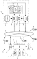
この発明に係る画像配信システム10は、図1に示すように、サーバ12と、多数の携帯電話14とから構成される。
各携帯電話14は、制御部16と、通信処理部18と、位置情報取得部20と、撮影部22と、入力部24と、ディスプレイ(LCD)26とを備えている。
制御部16は、携帯電話14のCPUが専用のアプリケーションプログラムに従って必要な処理を実行することによって実現される。
位置情報取得部20は、例えばGPS受信ユニットよりなり、GPS衛星からの信号を受信し、現在地の緯度・経度情報を抽出する機能を備えている。
撮影部22は、CCDやCMOSセンサよりなり、画像データを取り込む機能を備えている。
入力部24は、テキストデータや選択コマンドを入力するためのキーボードやタッチパネル等よりなる。
As shown in FIG. 1, an
Each
The
The position
The photographing
The
上記サーバ12は、画像情報登録部30と、画像情報抽出部32と、ルート探索部34と、ユーザデータベース35と、画像情報記憶部36とを備えている。
上記画像情報登録部30、画像情報抽出部32、ルート探索部34は、サーバ12のCPUがOS及び専用のアプリケーションプログラムに従って必要な処理を実行することによって実現される。
また、ユーザデータベース35及び画像情報記憶部36は、サーバ12のハードディスク内に設けられている。
画像情報記憶部36は、属性情報データベース38と画像ファイル格納部40とからなる。
The
The image
Further, the
The image
この画像配信システム10の場合、各ユーザの携帯電話14を通じて多数の風景画像をサーバ12に蓄積しておき、これを他のユーザの携帯電話14に配信することが前提となっている。
以下において、図2のフローチャートに従い、風景画像を蓄積する際の手順について説明する。
まずユーザは、携帯電話14にセットアップされた専用のアプリケーションプログラムを起動させ(S10)、図3に示すサービスメニュー画面42の中から「2.画像の撮影・投稿」を選択する(S12)。
この結果、携帯電話14のカメラ機能が起動し、ユーザは自己に関係の深い場所や感銘を受けた場所の風景を撮影部22を通じて撮影する(S14)。
これに対し制御部16は、撮影時における位置情報(緯度・経度)を位置情報取得部20から受け取ると共に、現在日時情報を図示しない時計回路から取得し(S16)、図4(a)に示す確認画面44をディスプレイ26に表示させる(S18)。
In the case of this
Hereinafter, a procedure for accumulating landscape images will be described with reference to the flowchart of FIG.
First, the user activates a dedicated application program set up in the mobile phone 14 (S10), and selects “2. Take / post image” from the
As a result, the camera function of the
On the other hand, the
ディスプレイ26上には、図示の通り、撮影した風景画像46と共に、位置情報48、撮影日時情報50、撮影者情報52、処理メニュー54が表示されている。
「撮影者」には、予めアプリケーションプログラム内に設定しておいたユーザの氏名が表示される。
これに対しユーザがメニュー中の「1.この内容で登録する」を選択すると(S20)、制御部16は撮影された画像ファイルに必要な属性情報を添付して通信処理部18に出力する。
画像ファイルに添付される属性情報としては、ユーザID、氏名、位置情報、日時情報などが該当する。
通信処理部18は、これらの情報を通信キャリアの無線パケット網やインターネットを含む通信ネットワーク42を通じてサーバ12に送信する(S22)。
On the
In “Photographer”, the name of the user set in advance in the application program is displayed.
On the other hand, when the user selects “1. Register with this content” in the menu (S20), the
The attribute information attached to the image file includes a user ID, name, position information, date information, and the like.
The
これを受けたサーバ12の画像情報登録部30は、ユーザデータベース35をチェックして認証を行った後(S24)、画像ファイルを画像ファイル格納部40に保存すると共に(S26)、その属性情報を属性情報データベース38に登録する(S28)。
図5は、属性情報データベース38のデータ項目例を示しており、画像IDを筆頭に、ユーザID、撮影者名、撮影日時、撮影位置、画像タイトル、メモ情報、季節、時間帯、画像ファイルの格納先(パス)が設定されている。
上記「季節」の項目には、画像情報登録部30によって撮影日時の属する季節(春、夏、秋、冬等)が記録される。
また、上記「時間帯」の項目には、画像情報登録部30によって撮影日時の属する時間帯(昼間、夕方、夜間等)が記録される。
なお、携帯電話14の時計が狂っている可能性があるため、撮影日時はサーバ12側で修正することもできる。
画像タイトルやメモ情報は必須のデータ項目ではないため、ユーザが携帯電話14で設定しなかった場合には、ブランクのままとなる。
In response to this, the image
FIG. 5 shows an example of data items in the
In the “season” item, the image
In the item “time zone”, the image
Note that since the clock of the
Since the image title and memo information are not indispensable data items, they remain blank when the user does not set them with the
図4(a)の確認画面においてユーザが「3.メモ情報を入力する」を選択すると、図4(b)に示すように、メモ入力画面56が表示される。
これに対しユーザが入力部24を介してメモ情報を入力し、「登録」ボタン58を選択すると、属性情報の一部として当該メモ情報がサーバ12に送信され、画像情報登録部30によって属性情報データベース38に格納される。
また、図4(a)の確認画面においてユーザが「2.タイトルを入力する」を選択すると、タイトルの入力欄が画面上に表示される(図示省略)。
これに対しユーザが入力部24を介してタイトルを入力し、「登録」ボタンを選択すると、属性情報の一部として当該タイトルがサーバ12に送信され、画像情報登録部30によって属性情報データベース38に格納される。
When the user selects “3. Input memo information” on the confirmation screen of FIG. 4A, a
On the other hand, when the user inputs memo information via the
When the user selects “2. Enter title” on the confirmation screen of FIG. 4A, a title input field is displayed on the screen (not shown).
On the other hand, when the user inputs a title via the
つぎに、図6及び図7のフローチャートに従い、ユーザに対して画像データを配信する際の手順について説明する。
まずユーザは、携帯電話14において専用のアプリケーションプログラムを起動し(S30)、図3のサービスメニュー中の「3.ナビの利用」を選択する(S32)。
この結果、図8(a)に示すように、「出発地」及び「目的地」を入力するルート設定画面60がディスプレイ26上に表示される(S34)。
デフォルトでは「出発地」として現在地点が、また「目的地」として予め登録したユーザの自宅、あるいは最後に入力した目的地が設定されている。
Next, a procedure for distributing image data to the user will be described with reference to the flowcharts of FIGS. 6 and 7.
First, the user activates a dedicated application program on the mobile phone 14 (S30), and selects “3. Use of navigation” in the service menu of FIG. 3 (S32).
As a result, as shown in FIG. 8A, a
By default, the current location is set as the “departure”, the home of the user registered in advance as the “destination”, or the last input destination is set.
これに対しユーザは、それぞれの「変更」ボタン61,62を選択することで出発地及び目的地を変更することができる。
例えば、目的地の「変更」ボタン61をユーザが選択すると(S36)、制御部16からサーバ12に対して目的地変更用画面の送信要求が送信される(S40)。
これを受けたサーバ12のルート探索部34からは、目的地変更用の画面が送信され(S72)、図示は省略したが、ディスプレイ26上に「住所で選択」、「電話番号で選択」、「公共施設」、「交通施設」、「ホテル」、「遊戯施設」等の選択ボタンが表示される。
これらの中で「ホテル」を選択すると、「都道府県」の選択画面が表示され、列挙された都道府県の中から「東京都」を選択すると、ホテルの名称が五十音順でリスト表示される。
この中からユーザが「東京ホテル」を選択すると、目的地の欄に東京ホテルが表示されることとなる(S44)。
On the other hand, the user can change the starting point and the destination by selecting the respective “change”
For example, when the user selects the “change”
In response to this, the
If you select “Hotel” from these, the “Prefecture” selection screen is displayed. If you select “Tokyo” from the listed prefectures, the hotel names are listed in alphabetical order. The
When the user selects “Tokyo Hotel” from among these, the Tokyo hotel is displayed in the destination column (S44).
出発地と目的地の設定を完了したユーザは、「探索開始」ボタン63を選択する。
この結果、出発地及び目的地を特定するルート探索要求を制御部16が生成し、通信処理部18を介してサーバ12に送信する(S46)。
これを受けたサーバ12のルート探索部34は、所定のアルゴリズムに従って出発地から目的地までの最適ルートを計算し(S48)、その座標データを画像情報抽出部32に出力する。
これに対し画像情報抽出部32は、当該最適ルート上に存在する画像情報(最適ルートの座標に対して所定距離内の位置情報を備えた画像情報)を属性情報データベース38から抽出し(S50)、その結果を携帯電話14に送信する(S52)。
The user who has completed the setting of the starting point and the destination selects the “search start”
As a result, the
In response to this, the
On the other hand, the image
これを受けた携帯電話14のディスプレイ26には、図8(b)に示すように、探索結果画面64が表示される(S54)。
ここでユーザが「案内開始」ボタン65を選択すると、制御部16からサーバ12に対して案内開始要求が送信される(S56)。
これを受けた画像情報抽出部32は、携帯電話14に対して各画像に関連付けられた位置情報を送信する(S58)。
In response to this, a
When the user selects the “start guidance”
Receiving this, the image
携帯電話14の制御部16は、送信された各画像の位置情報をメモリに蓄積する(S60)。
また、位置情報取得部20から出力される現在位置情報を、制御部16は定期的に取得する(S62)。
そして制御部16は、この現在位置情報の変遷を監視しておき、上記画像の位置情報に対して一定の距離以下に近づいた時点で、サーバ12に対して当該画像の配信を要求する(S66)。
The
Further, the
Then, the
これを受けたサーバ12の画像情報抽出部32は、当該画像ファイル及びその属性情報を抽出し、携帯電話14に対して送信する(S68)。
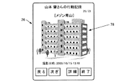
この結果、図9(a)に示すように、携帯電話14のディスプレイ26には、次ぎに目標とすべき風景画像の表示画面66が表示される(S70)。
このためユーザは、移動に伴ってタイムリーに配信される風景画像と、目の前の風景とを比較することにより、自分の歩いている道が正しいか否かを直感的に確認することができる。
上記の風景画像の配信要求処理(S66)、配信処理(S68)、表示処理(S70)は、ユーザが目的地に到着するまで継続される(S72)。
Receiving this, the image
As a result, as shown in FIG. 9A, the
For this reason, the user can intuitively confirm whether or not his / her walking path is correct by comparing the landscape image delivered in a timely manner with movement and the landscape in front of him / her. it can.
The landscape image distribution request processing (S66), distribution processing (S68), and display processing (S70) are continued until the user arrives at the destination (S72).
ある地点でユーザが「次ぎ」ボタン67を選択すると、制御部16からサーバ12に対して当該画像の配信要求が送信され、画像情報抽出部32から次に表示されるべき風景画像が配信される。
このため、ユーザは「次ぎ」ボタン67を次々と選択することにより、ルート上に設定された風景画像を前もって確認することができ、分岐点での進行方向を認識することも可能となる。
また、画面中には次の画像が表示される地点までの距離68が表示される。この画像間の距離は、各画像の位置情報に基づいて携帯電話14の制御部16が算出する。あるいは、サーバ12の画像情報抽出部32が予め画像間の距離を計算し、そのデータを携帯電話14に送信するように構成することもできる。
ディスプレイ26に特定の画像を表示させた状態でユーザが「詳細」ボタン69を選択すると、図9(b)に示すように、撮影者やメモ情報が記述された詳細画面70が画像情報抽出部32から送信され、ディスプレイ26上に表示される。
When the user selects the “next”
For this reason, the user can confirm the landscape image set on the route in advance by selecting the “next”
Further, the
When the user selects the “detail”
同一地点に複数の画像ファイルが登録されている場合、画像情報抽出部32は原則として撮影日時の最も新しい画像ファイルを優先的に配信する。
これに対しユーザは、ディスプレイ26に特定の画像を表示させた状態で「過去」ボタン71を選択することにより、サーバ12に対して一つ前の画像ファイルの配信を要求することができる。
これを受けた画像情報抽出部32は、該当の画像ファイルを画像ファイル格納部40から抽出し、携帯電話14に配信する。
したがってユーザは、同一地点で「過去」ボタン71を次々と選択することにより、当地の風景を遡って閲覧することができ、街並みの定点観測的な利用が可能となる。
最新の風景に戻りたい場合には、「最新」ボタン72を選択すればよい。
When a plurality of image files are registered at the same point, the image
On the other hand, the user can request the
Receiving this, the image
Therefore, the user can browse the scenery in this area retrospectively by selecting the “past”
In order to return to the latest scenery, the “latest”
ユーザは、任意の季節や時間帯の風景画像のみをディスプレイ26に表示させることもできる。
すなわち、図8(a)のルート設定画面60においてユーザが「季節・時間帯の設定」ボタン73を選択すると、図8(c)に示すように、画像情報抽出部32から携帯電話14に季節・時間帯の設定画面74が送信され、ディスプレイ26に表示される。
デフォルトでは「季節」として現在の季節である「秋」が、また「時間帯」として現在の時間帯である「昼間」が設定されている。
これに対しユーザは、それぞれの「変更」ボタン75,76を選択して変更用画面(図示省略)を呼び出すことで、季節及び時間帯を変更することができる。
The user can also display on the
That is, when the user selects the “set season / time zone”
By default, “autumn”, which is the current season, is set as “season”, and “daytime”, which is the current time zone, is set as “time zone”.
On the other hand, the user can change the season and time zone by selecting the respective “change”
季節と時間帯の設定を完了したユーザは、「設定」ボタン77を選択してルート設定画面60に戻り、「探索開始」ボタン63を選択する。
この結果、出発地、目的地、季節、時間帯を特定するルート探索要求が制御部16によって生成され、通信処理部18を介してサーバ12に送信される。
これを受けたサーバ12のルート探索部34は、出発地から目的地までの最適ルートを計算し、その座標データを画像情報抽出部32に出力する。
これに対し画像情報抽出部32は、当該最適ルート上に存在する画像情報の中で、指定された季節及び時間帯に合致する画像情報を属性情報データベース38から抽出し、その結果を携帯電話14に送信する。
この結果、携帯電話14のディスプレイ26にはユーザが指定した季節及び時間帯における風景画像のみが表示されることとなり、昼間の中にデートコースの夜景を確認したり、シーズン前に観光地の冬場の景色を堪能するといったことが可能となる。
The user who has completed the setting of the season and the time zone selects the “setting”
As a result, a route search request for specifying the departure place, destination, season, and time zone is generated by the
Receiving this, the
On the other hand, the image
As a result, only the landscape image in the season and time zone specified by the user is displayed on the
この画像配信システム10は、上記の非特許文献1に開示されたナビゲーションシステムと併用することも当然に可能である。
すなわち、このナビゲーションシステムによって出発地から目的地に至る最適ルートの設定、地図データの配信、ナレーション情報の配信等を実現し、これと並行してこの画像配信システム10による画像情報の配信を実行することにより、ユーザはディスプレイ26に表示された地図上でルートと現在位置を確認しつつ、画像情報が配置された個所に近づくと当地の風景画像がディスプレイ26に表示されるため、正しい道であることを直感的に確認できるようになる。
This
That is, this navigation system realizes the setting of the optimum route from the departure point to the destination, the distribution of map data, the distribution of narration information, and the like, and the distribution of image information by the
この画像配信システム10の場合、画像情報記憶部36にあらゆる地点に係る風景画像を蓄積しておくことが肝要となる。
そのために、システム管理者の側でランドマークとなる建物や地形の画像を多数収集し、事前に画像情報記憶部36に蓄積しておくこともできるが、画像提供者に対して何らかのインセンティブを用意することにより、一般ユーザからできるだけ多くの風景画像を投稿してもらうことが有効である。
In the case of the
To this end, the system administrator can collect many landmark and building images and store them in the image
例えば、図3のサービスメニュー画面42においてユーザが「4.自己の行動記録閲覧」を選択すると、制御部16からサーバ12に対して当該ユーザが撮影した画像情報の配信要求が出力される。
これを受けたサーバ12の画像情報抽出部32は、属性情報データベース38を参照し、当該ユーザに関連付けられた画像ファイルを画像ファイル格納部40から抽出した後、携帯電話14に送信する。
この結果、携帯電話14のディスプレイ26には、図10に示すように、当該ユーザがこれまでに撮影した風景画像の表示画面78が時系列順に表示される。
すなわち、ユーザはこのシステム10を自己の行動記録として利用可能となり、これが一つの励みとなって積極的に風景画像の投稿を行うようになることが期待できる。
For example, when the user selects “4. View own action record” on the
Upon receiving this, the image
As a result, on the
That is, the user can use the
上記においては、ユーザ側の端末として携帯電話14を例示したが、この発明はこれに限定されるものではなく、ディジタルカメラ機能やGPS機能、無線によるインターネット接続機能を備えた携帯情報端末(PDA)に専用のアプリケーションプログラムを搭載させたものをユーザ側の端末として採用することもできる。
In the above, the
10 画像配信システム
12 サーバ
14 携帯電話
16 制御部
18 通信処理部
20 撮影部
24 入力部
26 ディスプレイ
30 画像情報登録部
32 画像情報抽出部
34 ルート探索部
35 ユーザデータベース
36 画像情報記憶部
38 属性情報データベース
40 画像ファイル格納部
42 サービスメニュー
44 確認画面
46 風景画像
48 位置情報
50 撮影日時情報
52 撮影者情報
54 処理メニュー
56 メモ入力画面
58 「登録」ボタン
60 ルート設定画面
61 出発地の「変更」ボタン
62 目的地の「変更」ボタン
63 「探索開始」ボタン
64 探索結果画面
65 「案内開始」ボタン
66 風景画像の表示画面
67 「次ぎ」ボタン
68 次の画像が表示される地点までの距離
69 「詳細」ボタン
70 詳細画面
71 「過去」ボタン
72 「最新」ボタン
73 「季節・時間帯の設定」ボタン
74 季節・時間帯の設定画面
75 季節の「変更」ボタン
76 時間帯の「変更」ボタン
77 「設定」ボタン
78 自己の行動記録に係る風景画像の表示画面
10 Image distribution system
12 servers
14 Mobile phone
16 Control unit
18 Communication processor
20 Shooting section
24 Input section
26 display
30 Image information registration section
32 Image information extraction unit
34 Route search part
35 User database
36 Image information storage
38 Attribute information database
40 Image file storage
42 Service menu
44 Confirmation screen
46 Landscape image
48 Location information
50 Date and time information
52 Photographer information
54 Processing menu
56 Memo input screen
58 Register button
60 Route setting screen
61 "Change" button for departure location
62 Destination "Change" button
63 “Search” button
64 Search result screen
65 “Guidance start” button
66 Landscape image display screen
67 “Next” button
68 Distance to the point where the next image is displayed
69 Details button
70 Detailed screen
71 Past button
72 "Latest" button
73 “Set Season / Time” button
74 Season / Time Zone Settings Screen
75 Seasonal Change button
76 Change button for time zone
77 Settings button
78 Display screen of landscape images related to own action records
Claims (8)
上記携帯端末は、
画像を撮影する手段と、
携帯端末の位置情報を取得する手段と、
ディスプレイと、
入力手段と、
撮影した画像ファイル及びその位置情報をサーバに送信する手段と、
ディスプレイ上に出発地及び目的地を入力するための画面を表示させる手段と、
入力された出発地及び目的地をサーバに送信し、出発地及び目的地間を結ぶルート上に配置された画像の検索を要求する手段と、
サーバから送信された画像の位置情報を保存する記憶手段と、
現在位置情報と各画像の位置情報とを比較し、両者が所定距離内に近づいた場合に上記サーバに対して当該画像の配信を要求する手段と、
サーバから配信された画像を上記ディスプレイ上に表示させる手段とを備え、
上記サーバは、
携帯端末から送信された画像ファイルを位置情報に関連付けて記憶手段に格納する手段と、
携帯端末から送信された出発地及び目的地間を結ぶルートを探索する手段と、
当該ルートに対して所定距離内に位置する画像を抽出する手段と、
各画像の位置情報を携帯端末に送信する手段と、
携帯端末から特定位置における画像の配信要求が送信された場合に、該当の画像ファイルを抽出して携帯端末に配信する手段とを備えたことを特徴とする画像配信システム。 An image distribution system comprising a mobile terminal operated by a user and a server connected to the mobile terminal via a network including a wireless communication network,
The mobile device
Means for taking an image;
Means for obtaining location information of the mobile terminal;
Display,
Input means;
Means for transmitting the captured image file and its position information to the server;
Means for displaying a screen for inputting a starting point and a destination on the display;
Means for transmitting the input starting point and destination to the server and requesting a search for an image arranged on a route connecting the starting point and the destination;
Storage means for storing image position information transmitted from the server;
Means for comparing the current position information with the position information of each image, and requesting the server to deliver the image when both approaches within a predetermined distance;
Means for displaying the image distributed from the server on the display,
The server
Means for associating the image file transmitted from the portable terminal with the location information and storing it in the storage means;
Means for searching for a route connecting the starting point and the destination transmitted from the mobile terminal;
Means for extracting an image located within a predetermined distance with respect to the route;
Means for transmitting the position information of each image to the mobile terminal;
An image distribution system comprising: means for extracting a corresponding image file and distributing the image file to a portable terminal when a distribution request for the image at a specific position is transmitted from the portable terminal.
上記サーバは、
上記携帯端末から画像ファイル及びその位置情報が送信された場合に、当該画像ファイルを位置情報に関連付けて記憶手段に格納する手段と、
上記携帯端末から出発地及び目的地を特定する情報が送信された場合に、当該出発地及び目的地間を結ぶルートを探索する手段と、
当該ルートに対して所定距離内に位置する画像を抽出する手段と、
各画像の位置情報を携帯端末に送信する手段と、
携帯端末から特定位置における画像の配信要求が送信された場合に、該当の画像ファイルを抽出して携帯端末に配信する手段とを備えたことを特徴とする画像配信システム。 An image distribution system including a server connected to a mobile terminal operated by a user via a network including a wireless communication network,
The server
Means for storing the image file in the storage means in association with the position information when the image file and its position information are transmitted from the portable terminal;
Means for searching for a route connecting the departure point and the destination when the information specifying the departure point and the destination is transmitted from the mobile terminal;
Means for extracting an image located within a predetermined distance with respect to the route;
Means for transmitting the position information of each image to the mobile terminal;
An image distribution system comprising: means for extracting a corresponding image file and distributing the image file to a portable terminal when a distribution request for the image at a specific position is transmitted from the portable terminal.
携帯端末から送信された画像ファイルに日時情報を関連付けて記憶手段に格納する手段と、
特定位置に複数の画像ファイルが存在する場合に、各画像ファイルを日時順に整列する手段と、
携帯端末から当該位置における特定順位の画像の配信要求が送信された場合に、該当の画像ファイルを抽出して携帯端末に配信する手段とを備えたことを特徴とする請求項1または2に記載の画像配信システム。 The server
Means for associating the date and time information with the image file transmitted from the portable terminal and storing it in the storage means;
Means for arranging each image file in chronological order when there are a plurality of image files at a specific position;
The apparatus according to claim 1, further comprising: a unit that extracts a corresponding image file and distributes the image file to a portable terminal when a distribution request for the image of a specific order at the position is transmitted from the portable terminal. Image distribution system.
携帯端末から送信された画像ファイルに日時情報を関連付けて記憶手段に格納する手段と、
画像ファイルの日時情報に基づき、当該画像ファイルに季節を特定する情報を付加する手段と、
携帯端末から季節を特定した画像の検索要求が送信された場合に、当該季節に合致する画像ファイルを抽出し、各画像の位置情報を携帯端末に送信する手段とを備えたことを特徴とする請求項1〜3の何れかに記載の画像配信システム。 The server
Means for associating the date and time information with the image file transmitted from the portable terminal and storing it in the storage means;
Means for adding information identifying seasons to the image file based on the date and time information of the image file;
When a search request for an image specifying a season is transmitted from a mobile terminal, the image processing apparatus includes means for extracting an image file that matches the season and transmitting position information of each image to the mobile terminal. The image delivery system in any one of Claims 1-3.
携帯端末から送信された画像ファイルに日時情報を関連付けて記憶手段に格納する手段と、
画像ファイルの日時情報に基づき、当該画像ファイルに時間帯を特定する情報を付加する手段と、
携帯端末から時間帯を特定した画像の配信要求が送信された場合に、当該時間帯に合致する画像ファイルを抽出し、各画像の位置情報を携帯端末に送信する手段とを備えたことを特徴とする請求項1〜4の何れかに記載の画像配信システム。 The server
Means for associating the date and time information with the image file transmitted from the portable terminal and storing it in the storage means;
Means for adding information specifying a time zone to the image file based on the date and time information of the image file;
And a means for extracting an image file matching the time zone and transmitting the position information of each image to the mobile device when a delivery request for an image specifying the time zone is transmitted from the portable terminal. The image delivery system according to any one of claims 1 to 4.
画像ファイルと共にユーザを特定する情報をサーバに送信する手段と、
特定ユーザに係る画像の配信要求をサーバに送信する手段と、
サーバから配信された特定ユーザに係る画像をディスプレイ上に表示させる手段とを備え、
上記サーバは、
携帯端末から送信されたユーザを特定する情報を画像ファイルに関連付けて記憶手段に格納する手段と、
携帯端末から特定ユーザに係る画像ファイルの配信要求が送信された場合に、当該ユーザに関連付けられた画像ファイルを抽出し、当該携帯端末に配信する手段とを備えたことを特徴とする請求項1、3〜5の何れかに記載の画像配信システム。 The mobile device
Means for transmitting information identifying the user together with the image file to the server;
Means for transmitting an image distribution request for a specific user to a server;
Means for displaying on the display an image relating to a specific user distributed from the server,
The server
Means for associating information identifying the user transmitted from the portable terminal with the image file and storing in the storage means;
2. An apparatus according to claim 1, further comprising means for extracting an image file associated with the user and distributing the image file to the portable terminal when a distribution request for the image file relating to the specific user is transmitted from the portable terminal. The image delivery system according to any one of 3 to 5.
ルート上に配置された画像間の距離を算出する手段と、
算出された画像間の距離情報を携帯端末に送信する手段とを備え、
上記携帯端末は、
現在表示中の画像の次に表示される画像までの距離をディスプレイ上に表示させる手段を備えたことを特徴とする請求項1、3〜6の何れかに記載の画像配信システム。 The server
Means for calculating a distance between images arranged on the route;
Means for transmitting the calculated distance information between the images to the mobile terminal,
The mobile device
7. The image distribution system according to claim 1, further comprising means for displaying on a display a distance to an image displayed next to an image currently being displayed.
サーバから送信された画像ファイルの位置情報に基づき、ルート上に配置された画像間の距離を算出する手段と、
現在表示中の画像の次に表示される画像までの距離をディスプレイ上に表示させる手段とを備えたことを特徴とする請求項1、3〜7の何れかに記載の画像配信システム。
The mobile device
Means for calculating a distance between images arranged on the route based on position information of the image file transmitted from the server;
8. The image distribution system according to claim 1, further comprising means for displaying a distance to an image displayed next to an image currently displayed on a display.
Priority Applications (1)
| Application Number | Priority Date | Filing Date | Title |
|---|---|---|---|
| JP2004102479A JP2005294893A (en) | 2004-03-31 | 2004-03-31 | Image distribution system |
Applications Claiming Priority (1)
| Application Number | Priority Date | Filing Date | Title |
|---|---|---|---|
| JP2004102479A JP2005294893A (en) | 2004-03-31 | 2004-03-31 | Image distribution system |
Publications (1)
| Publication Number | Publication Date |
|---|---|
| JP2005294893A true JP2005294893A (en) | 2005-10-20 |
Family
ID=35327398
Family Applications (1)
| Application Number | Title | Priority Date | Filing Date |
|---|---|---|---|
| JP2004102479A Pending JP2005294893A (en) | 2004-03-31 | 2004-03-31 | Image distribution system |
Country Status (1)
| Country | Link |
|---|---|
| JP (1) | JP2005294893A (en) |
Cited By (14)
| Publication number | Priority date | Publication date | Assignee | Title |
|---|---|---|---|---|
| JP2008128820A (en) * | 2006-11-21 | 2008-06-05 | Rohm Co Ltd | Car navigation device |
| JP2009014376A (en) * | 2007-07-02 | 2009-01-22 | Pioneer Electronic Corp | Feature image data change notification device and feature image data change notification program |
| JP2010102685A (en) * | 2008-09-29 | 2010-05-06 | Hitachi Ltd | Advertisement information providing server and mobile terminal thereof |
| JP2010164402A (en) * | 2009-01-15 | 2010-07-29 | Panasonic Corp | Information collecting device, mobile terminal device, information center, and navigation system |
| JP2012063367A (en) * | 2011-12-14 | 2012-03-29 | Pioneer Electronic Corp | Feature image data notification device, feature image data notification method, and feature image data notification program |
| JP2012113580A (en) * | 2010-11-26 | 2012-06-14 | Nikon Corp | Information terminal |
| JP2013053982A (en) * | 2011-09-06 | 2013-03-21 | Dainippon Printing Co Ltd | Map presentation system in facility |
| KR101250444B1 (en) * | 2006-11-15 | 2013-04-09 | 에스케이플래닛 주식회사 | System and method for providing road guide service |
| JP2013097753A (en) * | 2011-11-07 | 2013-05-20 | Canon Marketing Japan Inc | Information processor, website system, control method, website system providing method and program thereof |
| JP2013152250A (en) * | 2013-04-26 | 2013-08-08 | Panasonic Corp | Mobile terminal and information center |
| JP2013200848A (en) * | 2012-03-26 | 2013-10-03 | Fujitsu Ltd | Method, program, and device for registration and extraction |
| WO2015015779A1 (en) * | 2013-07-31 | 2015-02-05 | パナソニック インテレクチュアル プロパティ コーポレーション オブ アメリカ | Information presentation method, operation program, and information presentation system |
| JP2016057284A (en) * | 2014-09-10 | 2016-04-21 | パナソニック インテレクチュアル プロパティ コーポレーション オブ アメリカPanasonic Intellectual Property Corporation of America | Route display method, route display device, and database creation method |
| JP2017040551A (en) * | 2015-08-19 | 2017-02-23 | 株式会社ユピテル | System and program |
-
2004
- 2004-03-31 JP JP2004102479A patent/JP2005294893A/en active Pending
Cited By (16)
| Publication number | Priority date | Publication date | Assignee | Title |
|---|---|---|---|---|
| KR101250444B1 (en) * | 2006-11-15 | 2013-04-09 | 에스케이플래닛 주식회사 | System and method for providing road guide service |
| JP2008128820A (en) * | 2006-11-21 | 2008-06-05 | Rohm Co Ltd | Car navigation device |
| JP2009014376A (en) * | 2007-07-02 | 2009-01-22 | Pioneer Electronic Corp | Feature image data change notification device and feature image data change notification program |
| JP2010102685A (en) * | 2008-09-29 | 2010-05-06 | Hitachi Ltd | Advertisement information providing server and mobile terminal thereof |
| JP2010164402A (en) * | 2009-01-15 | 2010-07-29 | Panasonic Corp | Information collecting device, mobile terminal device, information center, and navigation system |
| JP2012113580A (en) * | 2010-11-26 | 2012-06-14 | Nikon Corp | Information terminal |
| JP2013053982A (en) * | 2011-09-06 | 2013-03-21 | Dainippon Printing Co Ltd | Map presentation system in facility |
| JP2013097753A (en) * | 2011-11-07 | 2013-05-20 | Canon Marketing Japan Inc | Information processor, website system, control method, website system providing method and program thereof |
| JP2012063367A (en) * | 2011-12-14 | 2012-03-29 | Pioneer Electronic Corp | Feature image data notification device, feature image data notification method, and feature image data notification program |
| JP2013200848A (en) * | 2012-03-26 | 2013-10-03 | Fujitsu Ltd | Method, program, and device for registration and extraction |
| JP2013152250A (en) * | 2013-04-26 | 2013-08-08 | Panasonic Corp | Mobile terminal and information center |
| WO2015015779A1 (en) * | 2013-07-31 | 2015-02-05 | パナソニック インテレクチュアル プロパティ コーポレーション オブ アメリカ | Information presentation method, operation program, and information presentation system |
| JPWO2015015779A1 (en) * | 2013-07-31 | 2017-03-02 | パナソニック インテレクチュアル プロパティ コーポレーション オブ アメリカPanasonic Intellectual Property Corporation of America | Information presentation method, operation program, and information presentation system |
| US9924231B2 (en) | 2013-07-31 | 2018-03-20 | Panasonic Intellectual Property Corporation Of America | Information presentation method, operation program, and information presentation system |
| JP2016057284A (en) * | 2014-09-10 | 2016-04-21 | パナソニック インテレクチュアル プロパティ コーポレーション オブ アメリカPanasonic Intellectual Property Corporation of America | Route display method, route display device, and database creation method |
| JP2017040551A (en) * | 2015-08-19 | 2017-02-23 | 株式会社ユピテル | System and program |
Similar Documents
| Publication | Publication Date | Title |
|---|---|---|
| US12125276B2 (en) | Imaging device and information acquisition system in which an acquired image and associated information are held on a display | |
| US8730337B2 (en) | Portable information device, imaging apparatus and information acquisition system | |
| JP6045354B2 (en) | Guidance system, server, terminal device, guidance method and program | |
| US7272498B2 (en) | Method for incorporating images with a user perspective in navigation | |
| JP2005294893A (en) | Image distribution system | |
| JP2014135026A (en) | Display system, server, terminal device, display method and program | |
| JP2008033399A (en) | Information provision system | |
| JP2006112981A (en) | Information processing device | |
| JP6066824B2 (en) | Post information display system, server, terminal device, post information display method and program | |
| JP6367437B2 (en) | Terminal device, posted information transmission method, posted information transmission program, and posted information display system | |
| JP2014219886A (en) | Terminal device, submission information transmission method, submission information transmission program, and submission information display system | |
| JP6551946B2 (en) | Terminal device, post information transmission method, post information transmission program, and post information display system | |
| TW201224396A (en) | Methods and systems for obtaining location information | |
| HK1242876A1 (en) | Imaging device, information acquisition system, program and recording medium | |
| HK1175339A (en) | Imaging device, information acquisition system, and program | |
| HK1175339B (en) | Imaging device, information acquisition system, and program | |
| HK1242876B (en) | Imaging device, information acquisition system, program and recording medium | |
| HK1176200A (en) | Imaging device, information acquisition system, and program | |
| HK1176200B (en) | Imaging device, information acquisition system, and program |