JP2004504612A - Method and apparatus for searching for a mobile receiver using a wide area reference network that propagates ephemeris data - Google Patents
Method and apparatus for searching for a mobile receiver using a wide area reference network that propagates ephemeris data Download PDFInfo
- Publication number
- JP2004504612A JP2004504612A JP2002512830A JP2002512830A JP2004504612A JP 2004504612 A JP2004504612 A JP 2004504612A JP 2002512830 A JP2002512830 A JP 2002512830A JP 2002512830 A JP2002512830 A JP 2002512830A JP 2004504612 A JP2004504612 A JP 2004504612A
- Authority
- JP
- Japan
- Prior art keywords
- satellite
- data
- mobile receiver
- receiver
- mobile
- Prior art date
- Legal status (The legal status is an assumption and is not a legal conclusion. Google has not performed a legal analysis and makes no representation as to the accuracy of the status listed.)
- Abandoned
Links
Images


Classifications
-
- G—PHYSICS
- G01—MEASURING; TESTING
- G01S—RADIO DIRECTION-FINDING; RADIO NAVIGATION; DETERMINING DISTANCE OR VELOCITY BY USE OF RADIO WAVES; LOCATING OR PRESENCE-DETECTING BY USE OF THE REFLECTION OR RERADIATION OF RADIO WAVES; ANALOGOUS ARRANGEMENTS USING OTHER WAVES
- G01S19/00—Satellite radio beacon positioning systems; Determining position, velocity or attitude using signals transmitted by such systems
- G01S19/01—Satellite radio beacon positioning systems transmitting time-stamped messages, e.g. GPS [Global Positioning System], GLONASS [Global Orbiting Navigation Satellite System] or GALILEO
- G01S19/13—Receivers
- G01S19/24—Acquisition or tracking or demodulation of signals transmitted by the system
- G01S19/28—Satellite selection
-
- G—PHYSICS
- G01—MEASURING; TESTING
- G01S—RADIO DIRECTION-FINDING; RADIO NAVIGATION; DETERMINING DISTANCE OR VELOCITY BY USE OF RADIO WAVES; LOCATING OR PRESENCE-DETECTING BY USE OF THE REFLECTION OR RERADIATION OF RADIO WAVES; ANALOGOUS ARRANGEMENTS USING OTHER WAVES
- G01S19/00—Satellite radio beacon positioning systems; Determining position, velocity or attitude using signals transmitted by such systems
- G01S19/01—Satellite radio beacon positioning systems transmitting time-stamped messages, e.g. GPS [Global Positioning System], GLONASS [Global Orbiting Navigation Satellite System] or GALILEO
- G01S19/03—Cooperating elements; Interaction or communication between different cooperating elements or between cooperating elements and receivers
- G01S19/05—Cooperating elements; Interaction or communication between different cooperating elements or between cooperating elements and receivers providing aiding data
- G01S19/06—Cooperating elements; Interaction or communication between different cooperating elements or between cooperating elements and receivers providing aiding data employing an initial estimate of the location of the receiver as aiding data or in generating aiding data
-
- G—PHYSICS
- G01—MEASURING; TESTING
- G01S—RADIO DIRECTION-FINDING; RADIO NAVIGATION; DETERMINING DISTANCE OR VELOCITY BY USE OF RADIO WAVES; LOCATING OR PRESENCE-DETECTING BY USE OF THE REFLECTION OR RERADIATION OF RADIO WAVES; ANALOGOUS ARRANGEMENTS USING OTHER WAVES
- G01S19/00—Satellite radio beacon positioning systems; Determining position, velocity or attitude using signals transmitted by such systems
- G01S19/01—Satellite radio beacon positioning systems transmitting time-stamped messages, e.g. GPS [Global Positioning System], GLONASS [Global Orbiting Navigation Satellite System] or GALILEO
- G01S19/13—Receivers
- G01S19/24—Acquisition or tracking or demodulation of signals transmitted by the system
- G01S19/25—Acquisition or tracking or demodulation of signals transmitted by the system involving aiding data received from a cooperating element, e.g. assisted GPS
- G01S19/258—Acquisition or tracking or demodulation of signals transmitted by the system involving aiding data received from a cooperating element, e.g. assisted GPS relating to the satellite constellation, e.g. almanac, ephemeris data, lists of satellites in view
Landscapes
- Engineering & Computer Science (AREA)
- Radar, Positioning & Navigation (AREA)
- Remote Sensing (AREA)
- Computer Networks & Wireless Communication (AREA)
- Physics & Mathematics (AREA)
- General Physics & Mathematics (AREA)
- Position Fixing By Use Of Radio Waves (AREA)
- Complex Calculations (AREA)
- Radio Relay Systems (AREA)
Abstract
【課題】ワイドエリアネットワークの全地球測位システム(GPS)受信機と中央サイトの間の通信リンクを利用してGPS衛星軌道暦データを送る方法と装置を提供する。
【解決手段】全地球測位システム(GPS)移動受信機(114、118)と中央サイトの間の通信リンクを利用してGPS衛星(106)の遠隔測定データを送る方法と装置を提供する。中央サイト(108)は、全ての衛星からの遠隔測定データを中央サイトに送る基準衛星受信機のネットワークに接続される。移動GPS受信機(114、118)は、送られた遠隔測定データを使用して、GPS衛星信号の捕捉を助ける。衛星遠隔測定データを利用することによって、移動受信機の信号受信感度を改善する。
【選択図】図1A method and apparatus for transmitting GPS satellite ephemeris data utilizing a communication link between a global positioning system (GPS) receiver and a central site of a wide area network.
A method and apparatus for transmitting telemetry data of a GPS satellite (106) utilizing a communication link between a global positioning system (GPS) mobile receiver (114, 118) and a central site. The central site (108) is connected to a network of reference satellite receivers that send telemetry data from all satellites to the central site. The mobile GPS receivers (114, 118) use the telemetry data sent to help capture GPS satellite signals. The use of satellite telemetry data improves the signal reception sensitivity of mobile receivers.
[Selection diagram] Fig. 1
Description
【発明の属する技術分野】
(発明の背景)
本発明は、GPS受信機の信号処理に関する。特に、本発明は、弱信号強度の環境(例えば、室内)でGPS受信機がGPS衛星信号を捕捉して追跡可能にするために、GPS受信機に衛星データを送る方法と装置に関する。
【従来の技術】
【0001】
(背景技術の説明)
従来のGPS受信機では、衛星信号を捕捉し追跡するためにかなりの時間を要していた。そして、一旦捕捉すると、GPS受信機は衛星信号から遠隔測定データ(衛星暦と軌道暦)を抽出する。
GPS受信機では、これらのデータから、衛星信号の捕捉性能を向上させるための情報を計算することができる。システムが初めに捕捉するためには、信号強度がかなり大きな衛星信号が必要である。一旦GPS信号が捕捉され、衛星暦データや軌道暦データが衛星信号から抽出される間、信号強度は高いまま存続する必要がある。信号が非常に減衰すると追跡を逃す可能性があり、信号を再び捕捉しなければならなくなる。システム自体には、信号強度の弱い環境でGPS受信機が信号を捕捉することを困難にするか、もしくは、不可能にする固有のサーキュラリティがある。
【0002】
衛星信号の最初の捕捉を支援するために、多くのGPS受信機では衛星暦データのコピーを記憶し、そのデータから衛星信号の予想ドップラー周波数を計算することが可能である。個々のGPS受信機で有益な情報を計算し、そのデータを別のGPS受信機に送る技術が幾つか開発されている。2000年5月16日発行の米国特許第6,064,336号では、個別のGPS受信機によって衛星暦データが収集されその衛星暦データが移動受信機に送られる。そして、移動受信機では、衛星暦データを使用して衛星信号の予想ドップラー周波数を計算することによって、最初の信号捕捉を支援する。
【0003】
衛星暦データを受け取る利点は、各GPS衛星が全GPS衛星群の軌道情報を含む衛星暦データの全てを繰返し送り、それによって衛星に追従する1台のGPS受信機が衛星群内の全ての衛星に関する衛星暦データを収集し伝搬できることである。一方、衛星暦データを使用する際の欠点は、衛星軌道と衛星クロックの誤差モデルが精密でないため、衛星暦データは、周波数の不確かさを減らすことに役立つが、コード遅延の不確かさの探索ウィンドーを狭めて受信機の感度を向上させるためには役立たないことである。
【0004】
GPS受信機が、視界に入る全衛星の追跡を試みる以前にそれらの衛星に関する完全な軌道暦データセットを備えている場合には、捕捉時間が大幅に短縮され感度が改善されるはずである。これは、軌道暦データには衛星の位置と速度とクロック誤差を正確に記述したデータが含まれているからであり、GPS受信機はこのデータを使って、周波数の不確かさとコード遅延の不確かさによる探索ウィンドーを大幅に狭めて感度を向上させることができる。軌道暦データの欠点は、各衛星が独自の軌道暦データのみを送るため、1台のGPS受信機では衛星群にある全衛星の軌道暦データを収集し伝搬することができないことである。
【0005】
【発明が解決しようとする課題】
従って、GPS受信機システムには、衛星群にある全衛星についての衛星軌道暦データを伝搬し、それによって捕捉スピードと移動受信機の信号感度を向上させる技術が求められている。
【0006】
【課題を解決するための手段】
(発明の概要)
本発明は、ワイドエリアネットワークの全地球測位システム(GPS)受信機と中央サイトの間の通信リンクを利用してGPS衛星軌道暦データを送る方法と装置を提供する。GPS受信機のワイドエリアネットワークでは、衛星によって送られた軌道暦データが収集されそのデータが中央サイトへと伝えられる。中央サイトは軌道暦データを移動受信機に送る。移動GPS受信機は配送データを利用して、2つの点で感度を向上させる。第1に、そのデータによって受信機は通常検出できない非常に弱い信号を検出できるようになり、第2に、GPS受信機は衛星信号を長時間追跡することなく位置を計算することが可能になる。
【0007】
本発明の一実施形態では、衛星軌道暦データはそのまま、データに手を加えることなく再送される。次いで、GPS受信機は、まさに衛星から軌道暦データを受け取ったかのごとくこのデータを利用する。別の一実施形態では、中央サイトで軌道暦データから衛星擬似距離モデルを計算し、この擬似距離モデルをGPS受信機に送る。擬似距離モデルには、完全な軌道暦データよりも簡略化されたデータであるという特徴がある。
従って、GPS受信機で擬似距離モデルを利用する場合は、完全な軌道暦データを使用する場合程多くの計算を行う必要はない。
本発明の教示は、添付図面と合わせて上記の詳細な説明を熟考することにより容易に理解することができる。
【0008】
【発明の実施の形態】
理解を容易にするために、以下のような説明手順をとる。
概要の節では、本発明の各要素を紹介し、相互関係を説明する。
グローバル追従ネットワークの節では、全衛星を絶えず確実に追跡するために追跡ステーションの全世界ネットワークがどのように構築され展開されているかを説明する。
軌道暦データ処理の節では、衛星軌道暦データのコンパクトで単純なモデルを提供する本発明の一実施形態について説明する。
信号検出の節では、普通なら検出不可能な信号を検出するために、再送される衛星軌道暦データがGPS受信機でどのように利用されるかについて説明する。
感度向上の節では、移動受信機で時間と相関器のオフセットを計算するために、最も強い2つの衛星信号がどのように利用されるかについて説明する。尚、この情報を利用することによって、移動受信機が受信する微弱なGPS信号に対する感度を改善することができる。
【0009】
(概要)
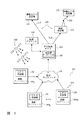
図1は、全地球測位システム(GPS)衛星データ送信システム100の一実施形態を示したものであって、本システムは以下の構成要素を備える。
a)通信ネットワーク105を介して相互接続された複数の追跡ステーション1041、1042、〜104nを備える基準ステーションネットワーク102。基準ステーション104は衛星のグローバルネットワーク、例えば全世界測位システム(GPS)内の全ての衛星106から軌道暦データを収集できるように広域に分散され、GPS受信機126を備える。軌道暦情報には、衛星の位置と時間に関する情報が入った900ビットのパケットが含まれる。
【0010】
b)中央処理サイト108。このサイトでは追跡ステーション104から軌道暦データを収集し、重複して発生した同一の軌道暦データを除去する軌道暦データプロセッサ128を備え、再送用の最新の軌道暦データを移動GPS受信機114、118に送る。
c)中央処理サイトから移動GPS受信機114への通信リンク120。通信リンク120は、移動GPS受信機114を中央処理サイト108に直接接続する陸線110、もしくは、その他の直接的な通信経路であってもよい。別の方法では、このリンクは、無線発信機116から移動受信機118への無線リンク122や、無線発信機116への陸線112などの幾つかのパーツを備えていてもよい。
【0011】
d)受信機が衛星群内の衛星106からGPS信号の検出を支援するために、再送された軌道暦データ(もしくは、その変更形態)を利用する移動GPS受信機114、118。
e)GPS受信機114、118の位置を計算する位置プロセッサ130。
これは、GPS受信機自体か、中央処理サイト108か、あるいは、移動GPS受信機が衛星106から得られた測定値の送り先であるその他のサイトであってもよい。
各衛星106は動作中に絶え間なく、特定の衛星に関する軌道暦情報を同報通信する。ネットワーク106は、衛星群内の全衛星106の軌道暦データを同時に包括的に取り込むために世界中に分散されている。
全軌道暦データを得るためには、3つ以上の追跡ステーション104が必要である。
【0012】
28個の衛星の各々は、地球の赤道から55度傾斜した軌道をとる。従って、衛星は、軌道球上で±55度の範囲の外側を移動することはない。その結果、地球の赤道の真上や120度離れた位置にある3つのステーションは、全衛星を視界内に捕らえることができる。しかしながら、その赤道上の正確な位置やその近辺に基準ステーションを配置することは現実的ではない。世界中の大都市に基準ステーションを配置するためには、視野に入れられる衛星106数の最少数は現実的には4個である。
【0013】
各追跡ステーション104には、視野内の全衛星106からの衛星信号を捕捉、追従するGPS受信機126が備わっている。追跡ステーション104は、各衛星の位置と衛星クロック情報をユニークに識別するための軌道暦情報、例えば、GPS信号を含む900ビットのパケットを抽出する。軌道暦情報は、例えば、地上の陸線ネットワーク105を介して中央処理サイト108に伝えられる。中央処理サイト108は、全てもしくは一部の軌道暦情報を1台以上の移動GPS受信機114、118に送る。中央処理サイトが移動GPS受信機の大体の位置を把握している場合、中央処理サイト108は、移動GPS受信機114や118の視野内に現在存在する(もしくは、視野内に入ろうとしている)衛星にだけに軌道暦情報を送ることができる。軌道暦情報は、陸線110またはその他の通信経路(例えば、インタ−ネット、電話線、光ファイバケーブルなど)を経由して伝えられる。別の方法では、軌道暦情報は、携帯電話や無線インターネットや無線機やテレビジョンなどの無線システム116を介して移動GPS受信機118に伝えられる。軌道暦情報の処理と利用については、以下(「軌道暦データ処理」と「信号検出」の節を参照)で説明する。
【0014】
(グローバル追従ネットワーク)
グローバルGPS基準ネットワーク102には、ネットワーク102内の追跡ステーション104によって全衛星が常に視界内にあるように配置されたステーション104が含まれる。従って、ネットワークでは、各衛星106の軌道暦情報をリアルタイムで利用できるため、ネットワークによって、軌道暦情報、もしくは導出された擬似距離モデルを必要とする移動受信機はそれらを利用することができる。
【0015】
基準ステーションの最小規模の完全なネットワークには、地球の周囲や赤道上や赤道近辺にほぼ均等に配置された3つのステーションが含まれている。図2には、地球204を取り囲むGPS軌道球202と全衛星の軌道の図示206が示されている。図3には、GPS軌道球で、(A、B、Cで示された)3つの追跡ステーションの水平面が交差する状態が示される。図3では、追跡ステーションの水平面上の軌道球の領域にはグレーの網掛けが施されている。2つの追跡ステーションの水平面上の軌道球上の領域には、少し濃い網掛けがなされている。GPS衛星が存在しない55度以上とそれ以下の軌道球の領域は白くなっている。図3から、GPSの軌道上の点は、基準ステーションA、B、Cの少なくとも1つの水平面上に常にあることが明らかである。
【0016】
赤道付近に基準ステーションを配置することは、商業的にも技術的にも現実的ではない。軌道暦情報を信頼性の高いネットワークを介して制御処理サイトに伝えるためには、優れた通信インフラの備わった大都市にサイトを配置することが好ましい。基準ステーションを赤道から離れた所に移すと、全ての衛星に常時対応するために3つ以上のステーションが必要になる。しかしながら、大都市もしくはその近辺に配置され、完璧に常時全GPS衛星に対応する4つ基準ステーションだけのネットワークを構築することは可能である。例えば、ハワイ(米国)のホノルルとブエノスアイレス(アルゼンチン)とテルアビブ(イスラエル)とパース(オーストラリア)にステーションを配置することも可能である。図4Aと図4Bは、GPS軌道球とそれらのステーションの水平面の交差状態を示す。GPS軌道上の点は、常に少なくとも1つの基準ステーションの水平面上に存在する。図4Aと図4Bには、宇宙の2点から見た軌道球が示されており、1点はスペインのほぼ上方(図4A)、もう1点は、球の反対側であってニュージーランドのほぼ上方(図4B)にある。図面には、図3と同様に網掛けが施されている。少なくとも1つの追跡ステーションの水平面上のGPS軌道球の領域にはグレーの網掛けが施され、濃グレー領域は、2ステーションの水平面が接する軌道球の部分を示す。
【0017】
(軌道暦データ処理)
軌道暦データは、衛星の擬似距離と擬似速度のモデルを計算するために使用される。擬似速度から、移動GPS受信機は衛星信号のドップラー周波数のオフセットを計算することができる。擬似距離モデルの計算は、移動受信機もしくは中央処理サイトで行われる。好適な実施形態の擬似距離モデルは、次のように中央サイトで計算される。
図5は、擬似距離モデルを生成する方法500のフロー図を示す。
ステップ502では、全ての追跡ステーションからの軌道暦データが中央処理サイトに集められる。軌道暦データは、全衛星から絶え間なく、送られる。このデータは大抵繰り返し送られ、新しい軌道暦データは通常2時間おきに送られる。軌道暦データには、TOEとして表わされる「軌道暦時刻」のタグが付加されている。このタグによって、軌道暦データの有効時間が示される。軌道暦データの計算内容はTOEから2時間以内であれば非常に正確である。衛星は最初にTOEでの2時間前の軌道暦データを送るので、軌道暦データは最大4時間まで非常に正確である。
【0018】
ステップ506では、中央処理サイトは、移動受信機が軌道暦データ(もしくは擬似距離モデル)を要求した時間Tに最も近いTOE付きの全軌道暦データを維持する。ステップ504では、時間Tは移動受信機から提供される。通常、時間Tは実際の現在時刻であるが、移動受信機が軌道暦データや擬似距離モデルを必要とする前にそれらを収集するために、移動受信機は最大4時間先までの時間が許される。また、移動受信機が以前に記憶したデータを処理する場合には、時間Tを過去の時間とすることもできる。
次に、ステップ508では、中央処理サイトは、時刻Tでの衛星の位置を計算する。好適な実施形態では、その位置は、GPSインタフェース制御に関する文書ICD−GPS−200−Bで与えられた計算式を用いて計算される。
【0019】
ステップ512で、中央処理サイトは移動GPS受信機の大体の位置を把握する。好適な実施形態の移動GPS受信機は、双方向ページングネットワークや移動電話ネットワークや同様の双方向無線ネットワークなどの無線通信リンクを介して中央処理サイトと通信する。そのような双方向無線ネットワークには、数マイルにわたる地域の信号を受信する通信塔がある。中央処理サイトは、移動GPSから最新の通信内容を受け取るために使用される無線塔の参照IDを獲得する。そして、中央処理サイトは、データベースからこの無線塔の位置を把握する。この位置は、移動GPSの大体の位置として使われる。
別の一実施形態での移動GPS受信機の大体の位置は、本発明を実現する際に利用される特定の通信ネットワークが対応する地域の単純に中央の地点であってよい。
【0020】
その他の別の実施形態での移動GPS受信機の大体の位置は、中央処理サイトのデータベースに保持された、最近判明した移動GPS受信機の位置であってもよい。
移動GPS受信機の大体の位置を推定するために、上述の方法の多くの様々な組み合せを用いることができることを理解されたい。
衛星の位置を計算してユーザの大体の位置を把握すると、中央処理サイトは、移動GPS受信機の水平面上に存在しているか、もしくは、そこに入ってくるのはどの衛星であるかを計算する(ステップ510)。ステップ514では、軌道暦データの再送を単に必要とするアプリケーションの中央処理サイトは、水平面上に存在するか、もしくは、そこに入ってくる衛星に関する軌道暦データを出力する。
【0021】
好適な実施形態では、水平面上に存在するか、もしくは、そこに入ってくる各衛星の時間Tと衛星PRN番号と擬似距離と擬似速度と擬似距離加速度を含む擬似距離モデルが計算される。
擬似距離モデルを計算するために、まず、ステップ516では、中央処理サイトは、移動GPS受信機の水平面上に存在するか、もしくは、そこに入ってくる全衛星の擬似距離を計算する。擬似距離とは、大体のGPSの位置と衛星の間の幾何学的な距離と、軌道暦データに示された衛星クロックのオフセットである。
【0022】
ステップ518では、擬似速度を衛星の速度とクロックの時差から計算することができる。衛星の速度は、衛星の位置の(ICD−GPS−200−Bに記載の)方程式を時間で微分することによって得られる。別の一実施形態では、衛星の速度は、2つの異なる時間における衛星の位置を計算してその2つの位置の差を計算することによって間接的に算出可能である。
その他の一実施形態では、擬似速度は2つの異なる時間における擬似距離を計算してその2つの擬似距離の差を計算することによって間接的に算出可能である。
ステップ520では、擬似距離加速度が同様の方法で(衛星速度とクロック時差を時間で微分するか、もしくは、擬似速度の差分をとることによって)計算される。
【0023】
次に、ステップ522では、完全な擬似距離モデルを構造に組込み、移動GPS受信機に出力する。
移動GPS受信機は、軌道暦データが有効な間、そのデータから導出される擬似距離モデルを利用することができる。
時間Tからしばらく経過後に擬似距離モデルを適用するために、移動受信機は、擬似距離モデルに含まれる擬似速度と擬似距離加速度の情報を使って擬似距離と擬似速度を繰返し伝搬させる。
別の一実施形態では、中央処理サイトは、未変更の軌道暦データ519を伝搬し、移動GPS受信機は、擬似距離モデルと擬似速度の微分を計算する。
【0024】
Krasnerの特許(米国特許第6,064,336号)では、ドップラー情報の有用性により周波数の不確かさが低減されるので、移動GPS受信機の手助けとなることを教示している。米国特許第6,064,336号には、ドップラーが見出される衛星暦情報を移動受信機に送る方法とシステムや、衛星暦データから見出される等価な情報を送る方法とシステムや、移動受信機に近い基地ステーションからドップラー測定値自体を送る方法とシステムが記述されている。本発明の別の一実施形態では、ドップラー情報を導出するために軌道暦データを利用することができる。次の節(「信号検出」)では、ドップラー情報を使用することによって擬似速度の不確かさ、即ち、探索する周波数ビン数が削減されるので信号捕捉の助けにはなるが、ドップラー情報によって擬似距離の不確かさ(即ちコード遅延)は削減されないことが理解される。
【0025】
(信号検出)
後述するが、軌道暦データ(もしくは、導出された擬似距離モデル)を利用して移動GPS受信機の信号捕捉と感度を向上させる方法が幾つかある。
軌道暦データもしくは擬似距離モデルによって衛星との仰角を予測することができるので、受信機は高度の高い衛星の信号を捕捉するように焦点が合わされて、一般的に、信号は障害物にぶつかることがなくなる。水平面以下(仰角がマイナス)に存在すると計算された衛星は無視される。また、このような衛星の選択は衛星軌道情報の衛星暦データを利用して行われるが、モデルや、モデルを生成する軌道暦データを提供することによって、移動受信機内に衛星暦データ用不揮発性記憶装置を組み込む必要がない。従って、この点において軌道暦データによって幾つかの利点がもたらされるが、後述するように、本発明の主な利点は信号捕捉と受信機の感度が改善されることである。
【0026】
「再送信される」もしくは「再同報通信される」軌道暦情報によって、2つの点で移動受信機の動作が改善される。
まず、移動受信機が衛星から軌道暦データを収集することが不要となる。軌道暦情報は、衛星から30秒おきに同報通信され、送信には18秒間要する。本発明を利用せずに軌道暦情報を受信するには、軌道暦情報が送信されている18秒の間、クリアで遮断のない情報を衛星から受け取ることが移動受信機にとって必要となる。環境と受信機の使用状態によっては、軌道暦情報を収集するまでに数分を要することがあるかもしれない、例えば、室内で利用するなどの多くのアプリケーションでは、移動受信機から衛星を見ることが困難であるかもしれない。
データ収集遅延を減らすために、本発明では、軌道暦データが直接移動受信機に提供される。
【0027】
次に、軌道暦データを上述したように利用することによって移動受信機で受信される衛星信号の擬似距離モデルが形成される。これらのモデルによって、幾つかの点で信号捕捉処理を速めることができる。
モデルを使って受信信号の擬似距離と擬似速度が予測される。ユーザの推定位置がかなり正確な場合には、擬似距離と擬似速度を推定することにとって、これらのモデルは非常に正確である。モデルを利用することによって、受信機は、予想信号に関する相関処理に専念することができる。
【0028】
図6は、移動GPS受信機の通常の周波数とタイミングの不確かさを描いたグラフ601を示す。y軸602の各行には異なる擬似速度が示されており、x軸の604の各列にはそれぞれ異なる擬似距離が示されている。衛星が広範囲にわたって移動することがあるので、本発明で利用できるような正確なモデルがないと速度の推定範囲は広くなり、また、PNコードの多数のサイクルにわたってもその範囲は変動する。黒いセル606で示されているように、軌道暦情報から得られる正確なモデルを利用して不確かさの範囲を狭めることができる。ここで、多くの受信機では1回のパスでこの狭範囲を探索できるので、時間のかかる逐次探索が不要となって、優れた感度を得るための総時間を長くとれることを説明する。
【0029】
優れた感度は次のように得られる。GPS受信機の感度は、受信機が相関器の出力を統合する時間の関数で表わされる。感度と総時間の関係は、グラフ608に示されている。探索すべきビンが多く存在する場合には、総時間610は、利用可能な探索総時間を探索ビン数で割った値に等しい。探索すべきビンが1つだけである場合には、総時間612は、利用可能な探索総時間に等しいため、608で示されているように感度が向上する。
【0030】
受信機の中には、ローカルクロックと同期がとれていないために擬似距離モデルから予測される擬似距離と擬似速度が正確でないものがあることに留意されたい。この場合、不確かな広い領域を探索することがまず必要になるが、それは最も強い信号を発する衛星に対してのみ行えばよい。ローカルクロックがGPS時間からほぼ1秒内に納まるように補正されることが分かっている場合は、1つの衛星だけをローカルな相関器のオフセットに同期させれば充分である。それ以降、残りの衛星の擬似距離の期待値と予想擬似速度を正確に計算することができる。ローカルクロックがほぼ1秒内(のずれである)と判明していない場合には、2つの衛星を使って、必要な2つのクロックパラメータ、即ち、ローカルクロックと相関器のオフセットを計算しなければならない。2つの衛星が必要であるという点は、誤解されることが多い。GPSに関する文献では、判明していないクロックのオフセットを把握するには1つの衛星で充分であると言われているが、ローカルクロックがすでにGPS時間とほぼ同期がとれているシステムに対してのみそのことが該当するということが認識されていない。GPS信号を常に追従する従来のGPS受信機のローカルクロックは、1秒よりずっと精密なGPS時間に同期している。最近の実施形態(例えば、米国特許第6,064,336号)の中には、GPS時間と同期させたネットワーク時間基準にローカルクロックを同期させることもある。しかしながら、本発明は、特に、ローカルクロックがGPS時間と同期してない実施形態で機能することに関する。このようなクロックパラメータの問題を解決する方法を以下に述べる。
【0031】
一旦判明していないクロックパラメータが計算されると、そのパラメータを使って残りの信号の弱い衛星の擬似距離モデルを調整して不確かさの範囲を狭領域に絞り込むことによって、まさに高感度を必要とする時に、即ち、弱い衛星信号を検出する場合に感度を高めることができる。
その他の受信機では、ローカルクロックとクロックレートがかなり正確である場合がある。例えば、クロック信号がGPSタイミング(例えば、双方向ページングネットワーク)に同期する無線媒体から得られた場合は、通常、そのクロックパラメータは正確である。この場合、クロック効果はなく、始めから狭い探索領域を利用することができる。
【0032】
本発明の利点を定量化するために、ユーザの位置が双方向ページャ塔の受信エリア(2マイル)内にあると判明している場合を検討する。この場合、(ミリ秒で表わされた)擬似距離は100分の1ミリ秒の精度まで事前に計算可能である。本発明を使用しないと、衛星から送られたコードを追跡するために、GPS受信機は可能性のある全てのコード遅延1ミリ秒にわたって探索することになる。本発明を使用すると、探索ウィンドーが100倍にまで削減されGPS受信機が高速化し、さらに重要なことは、(上述したように)長い総時間を使えるようになって、受信機が、例えば、室内で発生する弱い信号も検出できることである。
移動受信機に軌道暦データもしくは導出された擬似距離モデルが備わることによるその他の利点は、上述したように総時間が長くなることを除けば、予想距離内で生じる相関性のみを検討することによって「偽ピーク」を識別することが大幅に減るので、真の相関性を識別する処理がより確固としたものになることである。
【0033】
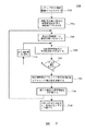
感度を高めるために軌道暦データ(もしくは、導出された擬似距離モデル)を利用する実施形態の1つを図7でさらに説明する。
図7は、信号探索方法700のフロー図である。この方法は、ステップ702で擬似距離モデルを入力することから始まる。前述したように、この擬似距離モデルは、移動受信機自体あるいは中央処理サイトで軌道暦データから計算される。ステップ704では、モデルは移動装置の現時刻で適用され、GPS衛星信号の現在の予想周波数と予想タイミング、ならびに、これらの値の不確かさの期待値を推定するために利用されて、各衛星の周波数/コード遅延探索ウィンドーが形成される。周波数と遅延の最適な推定値にこのウィンドー中心が置かれるが、大体のユーザ位置や無線搬送波からの時間/周波数転送エラーなどを含むモデリング処理エラーのために、実際は最適な推定値ではない可能性がある。さらに、周波数の不確かさは多数の周波数探索ビンに分けられて、周波数探索ウィンドーが網羅される。図6に示されるように、探索ビンの数は、擬似距離モデルを利用することによって劇的に削減される。
【0034】
ステップ706では、第1の探索周波数に対する搬送波補正をプログラムするように、検出と測定の処理が設定される。ステップ708では、遅延ウィンドーの遅延範囲内での信号相関性を探索するためにコード相関器を動作させる。そのコード相関器は当技術分野では一般的なものであるが、本発明によって、相関器が探索する必要のあるコード遅延数が劇的に削減されるので、各コード遅延の総時間が長くなり、よって受信機の感度が向上する。
ステップ710では、方法700によって信号が検出されたかどうかが問い合わされる。信号が未検出の場合には、ステップ712では、次の探索周波数に搬送波補正がセットされ、この探索は、信号が検出されるかあるいは周波数探索ビンがなくなるまで続けられる。
【0035】
本方法700のステップ710では、問い合せに対して肯定回答が得られた場合、ステップ714でその信号を利用してクロック時間の遅延とクロック周波数のオフセットについての推定値をさらに改善する。ステップ716では、この情報を利用して残りの未検出の衛星の周波数/遅延探索ウィンドーを再度計算する。ステップ718では、全ての衛星が検出されるかあるいは探索ウィンドーがなくなるまでこの処理が続けられる。
図7の方法は、時間と周波数を推定するGPS信号処理機能に基づいて探索処理をガイドするために使用される様々なアルゴリズムのうちの1つの例である。さらに、信号自体が衰弱したり、遮断される場合があるので、様々な再試行メカニズムを含むようにアルゴリズムを変更することが可能である。
【0036】
(感度向上)
(図6で説明したように)受信機の感度を高めるために、本発明では、移動装置の大体の位置を利用して擬似距離の期待値が計算されるので、擬似距離の不確かさが低減する。しかしながら、本発明の受信機で擬似距離の期待値を計算するには次の3つのデータが必要である。
1.移動装置の大体の位置(真の位置から数マイル以内)。
2.移動装置の大体の時間(真の時間から約1秒以内)。
3.移動装置の相関器クロックのオフセット(真のオフセットから数ミリ秒の範囲内)。
【0037】
3つのデータが正確であるほど、本発明によって擬似距離の不確かさがより的確に削減されるので、感度が改善される(図6参照)。好適な実施形態では、移動装置が最後に利用した無線塔の既知の位置から移動装置の大体の位置が判断される。通常、双方向ページャや携帯電話の無線塔からの受信エリアは3キロメートルである。従って、移動装置の大体の位置は3キロメートル以内であるとわかり、擬似距離の推定値に生じる誤差は3キロメートル以下となる。図6を参照すると、支援のないGPS受信機の擬似距離の最大の不確かさは1コード・エポック、即ち、約300キロメートルに匹敵することに留意されたい。従って、わかったことが3キロメートルもの大まかな位置であっても、擬似距離の不確かさは100分の1に低減させることができる。
【0038】
また、タイミング誤差によって擬似距離の期待値に誤差が生じる。擬似距離の期待値を計算するためには、受信機で衛星の宇宙での位置を計算する必要がある。
地上のある地点から衛星までの距離は1秒につき±800メートルの割合で変わる。従って、1秒毎の時間の誤差が、最長800メートルに及ぶ誤差距離(擬似距離)となる。
GPSに関する文献で既に公知のように、移動装置の相関器の遅延オフセットによって擬似距離の測定値に直接的な誤差が生じる。
未知の相関器遅延オフセットが1ミリ秒あると、距離の測定値に300メートルもの誤差が生じる。
【0039】
従って、(図6で示されているように)擬似距離の推定値を数キロメートル以内におさめるためには、本発明の受信機では上記の擬似距離に関する位置と時間と相関器の遅延オフセットの推定値が必要になる。
移動装置の実時間が数秒レベルより正確に把握されていない実施形態や、相関器遅延オフセットが判明していない実施形態では、2つの衛星の測定値を利用して次のように解決される。
【0040】
擬似距離の誤差と2つのクロック誤差の関係を示す方程式は、
y=c×dtc−rangeRate×dts (1)
上式では、yは「擬似距離残差」、即ち、擬似距離の期待値と測定擬似距離の差であり、cは光の速度、dtcは相関器の遅延オフセット、dtsは実時間の推定値の誤差である。
図8は、クロックパラメータを改善して受信機の感度を高める方法800のフロー図を示したものである。方法800は次のステップからなる。
ステップ802では、既知の最適なクロックパラメータを利用して全衛星の擬似距離の期待値を計算する。
【0041】
ステップ802では、最も強い信号強度を用いて、2つの最も信号の強い衛星の擬似距離を測定する。
ステップ806では、それらの2つの測定値を使って、未知のdtcとdtsの2つの値を方程式(1)で解く。
ステップ808では、dtcとdtsを使って、(信号の弱い)残りの衛星に関する擬似距離の期待値の推定値を改善する。
ステップ810では、図6に示されるように、これらの改善された擬似距離の期待値を使って、擬似距離の不確かさを低減させ、受信機の感度を向上させる。
本明細書で本発明の教示を包含する様々な実施形態を詳細に示し説明してきたが、当業者であればそのような教示を包含するその他の多くの変形形態を容易に考案することができる。
【0042】
【図面の簡単な説明】
【図1】図1は、本発明のワイドエリア基準ステーションネットワークの構成を示す。
【図2】図2は、GPS軌道球を示す。
【図3】図3は、GPS軌道球と3つの基準ステーションの水平面の交差状態を示す。
【図4】図4Aと4Bは、GPS軌道球と4つの基準ステーションの水平面の交差状態を示す。
【図5】図5は、擬似距離モデルを生成する方法のフロー図を示す。
【図6】図6は、移動GPS受信機のタイミング(擬似距離)と周波数(擬似速度)の不確かさ、ならびに、それら2つの不確かさを低減することによって感度が向上したことを示すグラフである。
【図7】図7は、時間(擬似距離)/周波数(擬似距離割合)ウィンドーによって探索する方法のフロー図を示す。
【図8】図8は、強信号強度の衛星の擬似距離情報を利用して、低信号強度の衛星から受信された信号に対する受信機感度を向上させる方法のフロー図を示す。TECHNICAL FIELD OF THE INVENTION
(Background of the Invention)
The present invention relates to signal processing for a GPS receiver. In particular, the present invention relates to a method and apparatus for sending satellite data to a GPS receiver to enable the GPS receiver to capture and track GPS satellite signals in a low signal strength environment (eg, indoors).
[Prior art]
[0001]
(Description of Background Art)
In conventional GPS receivers, it took a considerable amount of time to acquire and track satellite signals. Once captured, the GPS receiver extracts telemetry data (satellite and ephemeris) from the satellite signals.
The GPS receiver can calculate information for improving the capturing performance of the satellite signal from these data. For the system to initially acquire, it requires a satellite signal of significant signal strength. Once the GPS signal is captured and the almanac data or ephemeris data is extracted from the satellite signal, the signal strength must remain high. If the signal decays too much, tracking can be missed and the signal must be reacquired. The system itself has an inherent circularity that makes it difficult or impossible for a GPS receiver to capture the signal in low signal strength environments.
[0002]
To assist initial acquisition of satellite signals, many GPS receivers can store a copy of almanac data and calculate the expected Doppler frequency of the satellite signal from the data. Several techniques have been developed to calculate useful information at each GPS receiver and send that data to another GPS receiver. In U.S. Patent No. 6,064,336, issued May 16, 2000, almanac data is collected by a separate GPS receiver and the almanac data is sent to a mobile receiver. The mobile receiver then assists in initial signal acquisition by calculating the expected Doppler frequency of the satellite signal using the almanac data.
[0003]
The advantage of receiving the almanac data is that each GPS satellite repeatedly sends all of the almanac data including the orbital information of the entire GPS constellation, so that one GPS receiver following the satellite will have all satellites in the constellation. Satellite data can be collected and propagated. On the other hand, the disadvantage of using almanac data is that the almanac and satellite clock error models are inexact, so almanac data can help reduce frequency uncertainty, but the code delay uncertainty search window. To improve the sensitivity of the receiver by narrowing the receiver.
[0004]
If the GPS receiver had a complete ephemeris dataset for those satellites before attempting to track all the satellites in view, acquisition time would be significantly reduced and sensitivity would be improved. This is because ephemeris data contains data that accurately describes the satellite's position, velocity, and clock error, and the GPS receiver uses this data to determine the frequency uncertainty and code delay uncertainty. Can greatly narrow the search window and improve the sensitivity. A disadvantage of ephemeris data is that one GPS receiver cannot collect and propagate ephemeris data for all satellites in a constellation because each satellite sends only its own ephemeris data.
[0005]
[Problems to be solved by the invention]
Accordingly, there is a need for a technology for a GPS receiver system that propagates satellite ephemeris data for all satellites in a constellation, thereby improving acquisition speed and signal sensitivity of a mobile receiver.
[0006]
[Means for Solving the Problems]
(Summary of the Invention)
The present invention provides a method and apparatus for transmitting GPS ephemeris data utilizing a communication link between a global positioning system (GPS) receiver of a wide area network and a central site. In a GPS receiver wide area network, ephemeris data sent by satellite is collected and transmitted to a central site. The central site sends ephemeris data to the mobile receiver. Mobile GPS receivers use delivery data to improve sensitivity in two ways. First, the data allows the receiver to detect very weak signals that would normally not be detectable, and second, GPS receivers can calculate position without having to track satellite signals for long periods of time. .
[0007]
In one embodiment of the present invention, the satellite ephemeris data is retransmitted as is without any modification to the data. The GPS receiver then uses this data as if it had received ephemeris data from the satellite. In another embodiment, a central site calculates a satellite pseudorange model from ephemeris data and sends the pseudorange model to a GPS receiver. The pseudorange model is characterized in that it is data that is more simplified than complete ephemeris data.
Therefore, when using a pseudorange model in a GPS receiver, it is not necessary to perform as many calculations as when using complete ephemeris data.
The teachings of the present invention can be readily understood by considering the above detailed description in conjunction with the accompanying drawings.
[0008]
BEST MODE FOR CARRYING OUT THE INVENTION
To facilitate understanding, the following explanation procedure is taken.
Overview Section introduces each element of the present invention and explains the interrelationships.
Global tracking network The section describes how a global network of tracking stations is built and deployed to constantly and reliably track all satellites.
Ephemeris data processing Section describes one embodiment of the present invention that provides a compact and simple model of satellite ephemeris data.
Signal detection The section describes how retransmitted satellite ephemeris data is used in GPS receivers to detect otherwise undetectable signals.
Improve sensitivity The section describes how the two strongest satellite signals are used to calculate the time and correlator offsets in a mobile receiver. By using this information, the sensitivity to a weak GPS signal received by the mobile receiver can be improved.
[0009]
(Overview)
FIG. 1 shows an embodiment of a global positioning system (GPS) satellite
a) a plurality of
[0010]
b)
c) A
[0011]
d)
e) a
This may be the GPS receiver itself, the
Each satellite continuously broadcasts ephemeris information for a particular satellite during operation.
Three or
[0012]
Each of the 28 satellites orbits at an angle of 55 degrees from the Earth's equator. Therefore, the satellite does not move outside the range of ± 55 degrees on the orbit. As a result, three stations just above the earth's equator and 120 degrees away can capture all satellites in sight. However, it is not practical to place the reference station at or near the exact location on the equator. In order to place reference stations in large cities around the world, the minimum number of
[0013]
Each tracking
[0014]
(Global Tracking Network)
The global
[0015]
The smallest complete network of reference stations includes three stations located approximately equally around the earth, on the equator, or near the equator. FIG. 2 shows a GPS orbit sphere 202 surrounding the earth 204 and an illustration 206 of the orbits of all satellites. FIG. 3 shows a horizontal orbital intersection of three tracking stations (indicated by A, B, and C) in a GPS orbit. In FIG. 3, the area of the orbiting sphere on the horizontal plane of the tracking station is shaded in gray. The area on the orbit sphere on the horizontal plane of the two tracking stations is slightly shaded. The area of the orbital sphere above 55 degrees and below which no GPS satellites are present is white. From FIG. 3 it is clear that the point on the GPS orbit is always on the horizontal plane of at least one of the reference stations A, B, C.
[0016]
Placing a reference station near the equator is not commercially or technically practical. In order to transmit ephemeris information to a control processing site via a highly reliable network, it is preferable to arrange the site in a large city equipped with an excellent communication infrastructure. Moving the reference station away from the equator requires more than two stations to keep up with all satellites. However, it is possible to construct a network of only four reference stations located in or near a metropolitan city and perfectly consistently serving all GPS satellites. For example, stations may be located in Honolulu, Buenos Aires (Argentina), Tel Aviv (Israel) and Perth (Australia) in Hawaii (USA). FIGS. 4A and 4B show the intersection of the GPS orbit and the horizontal plane of those stations. A point on the GPS orbit is always on the horizontal plane of at least one reference station. 4A and 4B show orbital spheres from two points in the universe, one point almost above Spain (Figure 4A) and another point on the opposite side of the sphere, almost in New Zealand. Above (FIG. 4B). The drawing is hatched as in FIG. The area of the orbital sphere on the horizontal plane of at least one tracking station is shaded gray, and the dark gray area indicates the portion of the orbital sphere where the horizontal planes of the two stations meet.
[0017]
(Ephemeral data processing)
The ephemeris data is used to calculate a pseudorange and pseudospeed model of the satellite. From the pseudo speed, the mobile GPS receiver can calculate the Doppler frequency offset of the satellite signal. The calculation of the pseudorange model is performed at the mobile receiver or central processing site. The pseudorange model of the preferred embodiment is calculated at the central site as follows.
FIG. 5 shows a flow diagram of a
At
[0018]
At
Next, at
[0019]
At
The approximate location of the mobile GPS receiver in another embodiment may simply be a central point in the area that the particular communication network utilized in implementing the present invention corresponds to.
[0020]
The approximate location of the mobile GPS receiver in other alternative embodiments may be a recently known location of the mobile GPS receiver maintained in a database at the central processing site.
It should be understood that many different combinations of the above methods can be used to estimate the approximate location of a mobile GPS receiver.
Once the satellite's location has been calculated and the user's approximate location has been determined, the central processing site calculates which satellite is on the horizontal plane of the mobile GPS receiver or which satellite is coming into it. (Step 510). In step 514, the central processing site of the application that simply needs to retransmit the ephemeris data outputs ephemeris data for satellites that lie on or enter the horizontal plane.
[0021]
In a preferred embodiment, a pseudorange model is calculated that includes the time T, satellite PRN number, pseudorange, pseudospeed, and pseudorange acceleration of each satellite that lies on or enters the horizontal plane.
To calculate the pseudorange model, first, at
[0022]
At
In another embodiment, the pseudo speed can be calculated indirectly by calculating the pseudorange at two different times and calculating the difference between the two pseudoranges.
At
[0023]
Next, in
Mobile GPS receivers can utilize pseudorange models derived from ephemeris data while the data is valid.
In order to apply the pseudorange model after a lapse of time T, the mobile receiver repeatedly propagates the pseudorange and pseudospeed using the pseudospeed and pseudorange acceleration information included in the pseudorange model.
In another embodiment, the central processing site propagates the unaltered ephemeris data 519, and the mobile GPS receiver calculates the pseudorange model and the pseudovelocity derivative.
[0024]
The Krasner patent (U.S. Pat. No. 6,064,336) teaches that the usefulness of Doppler information reduces frequency uncertainty and thus helps mobile GPS receivers. U.S. Pat. No. 6,064,336 describes a method and system for sending Doppler found almanac information to a mobile receiver, a method and system for sending equivalent information found from almanac data, and a mobile receiver. A method and system for sending Doppler measurements themselves from nearby base stations is described. In another embodiment of the present invention, ephemeris data can be used to derive Doppler information. The next section (" Signal detection )), The use of Doppler information helps in signal acquisition by reducing the pseudo-rate uncertainty, ie, the number of frequency bins to search, but the Doppler information provides pseudo-range uncertainty (ie, code delay). ) Is not reduced.
[0025]
(Signal detection)
As will be described later, there are several methods for improving the signal acquisition and sensitivity of the mobile GPS receiver using the ephemeris data (or the derived pseudorange model).
The receiver can be focused to capture high altitude satellite signals, as ephemeris data or pseudorange models can predict the elevation of the satellite, and the signal will generally hit obstacles Disappears. Satellites calculated to be below the horizontal plane (negative elevation) are ignored. The selection of such a satellite is performed using the almanac data of the satellite orbit information. However, by providing the ephemeris data for generating the model and the model, the non-volatile ephemeris data is stored in the mobile receiver. There is no need to incorporate storage. Thus, while ephemeris data offers several advantages in this regard, as will be described, the main advantages of the present invention are improved signal acquisition and receiver sensitivity.
[0026]
"Retransmitted" or "rebroadcast" ephemeris information improves the operation of the mobile receiver in two respects.
First, the mobile receiver does not need to collect ephemeris data from satellites. The ephemeris information is broadcast from the satellite every 30 seconds, and transmission takes 18 seconds. To receive ephemeris information without utilizing the present invention, it is necessary for the mobile receiver to receive clear, uninterrupted information from the satellite during the 18 seconds that ephemeris information is being transmitted. Depending on the environment and usage of the receiver, it may take several minutes to collect ephemeris information.For many applications, such as indoor use, seeing the satellite from a mobile receiver May be difficult.
In order to reduce the data collection delay, the present invention provides ephemeris data directly to the mobile receiver.
[0027]
Next, a pseudorange model of the satellite signal received at the mobile receiver is formed by utilizing the ephemeris data as described above. These models can speed up the signal acquisition process in several ways.
The pseudo-range and pseudo-speed of the received signal are predicted using the model. These models are very accurate for estimating pseudoranges and pseudovelocities if the user's estimated position is fairly accurate. By utilizing the model, the receiver can concentrate on the correlation process on the expected signal.
[0028]
FIG. 6 shows a
[0029]
Excellent sensitivity is obtained as follows. The sensitivity of a GPS receiver is a function of the time at which the receiver integrates the output of the correlator. The relationship between sensitivity and total time is shown in
[0030]
Note that for some receivers, the pseudorange and pseudospeed predicted from the pseudorange model are not accurate because they are not synchronized with the local clock. In this case, it is first necessary to search an uncertain large area, but only for the satellite that emits the strongest signal. If it is known that the local clock is corrected to fall within approximately one second of GPS time, it is sufficient to synchronize only one satellite to the offset of the local correlator. Thereafter, the expected value of the pseudorange and the estimated pseudospeed of the remaining satellites can be accurately calculated. If the local clock is not known to be within approximately one second (offset), two satellites must be used to calculate the two required clock parameters, the local clock and the correlator offset. No. The need for two satellites is often misunderstood. The GPS literature states that one satellite is sufficient to determine the unknown clock offset, but only for systems where the local clock is already nearly synchronized with GPS time. It is not recognized that this is the case. The local clock of a conventional GPS receiver, which always tracks the GPS signal, is synchronized to GPS time, which is much finer than one second. In some recent embodiments (eg, US Pat. No. 6,064,336), the local clock is synchronized to a network time reference that is synchronized to GPS time. However, the invention is particularly concerned with working in embodiments where the local clock is not synchronized with GPS time. A method for solving such a problem of the clock parameter will be described below.
[0031]
Once the unknown clock parameters are calculated, they just need high sensitivity by using them to adjust the pseudorange model of the remaining weak signal satellites to narrow the range of uncertainty to a small area. The sensitivity, that is, when detecting a weak satellite signal.
For other receivers, the local clock and clock rate may be quite accurate. For example, if the clock signal is derived from a wireless medium that is synchronized to GPS timing (eg, a two-way paging network), the clock parameters are usually accurate. In this case, there is no clock effect, and a narrow search area can be used from the beginning.
[0032]
To quantify the benefits of the present invention, consider the case where the user's location is known to be within the reception area (two miles) of the two-way pager tower. In this case, the pseudorange (expressed in milliseconds) can be pre-calculated to an accuracy of one hundredth of a millisecond. Without using the present invention, the GPS receiver would search over all possible code delays of 1 millisecond to track the code sent from the satellite. Using the present invention, the search window is reduced by a factor of 100 and the GPS receiver is sped up, and more importantly, a long total time can be used (as described above) so that the receiver can, for example, A weak signal generated indoors can also be detected.
Another advantage of having a mobile receiver with ephemeris data or a derived pseudorange model is that by considering only the correlations that occur within the expected distance, except for the longer total time as described above. The identification of "false peaks" is greatly reduced, making the process of identifying true correlations more robust.
[0033]
One embodiment utilizing ephemeris data (or a derived pseudorange model) to increase sensitivity is further described in FIG.
FIG. 7 is a flowchart of the
[0034]
In
In
[0035]
At
The method of FIG. 7 is one example of one of a variety of algorithms used to guide the search process based on a GPS signal processing function that estimates time and frequency. In addition, the algorithm can be modified to include various retry mechanisms, as the signal itself may be weakened or interrupted.
[0036]
(Improved sensitivity)
In order to increase the sensitivity of the receiver (as explained in FIG. 6), the present invention utilizes the approximate position of the mobile device to calculate the expected value of the pseudorange, thus reducing the pseudorange uncertainty. I do. However, the following three data are required to calculate the expected value of the pseudorange with the receiver of the present invention.
1. The approximate location of the mobile device (within a few miles from its true position).
2. The approximate time of the mobile device (within about one second from the true time).
3. Mobile device correlator clock offset (within milliseconds from true offset).
[0037]
The more accurate the three data, the better the sensitivity is, since the pseudorange uncertainty is better reduced by the present invention (see FIG. 6). In a preferred embodiment, the approximate location of the mobile device is determined from the known location of the radio tower last utilized by the mobile device. Typically, the area covered by a two-way pager or mobile phone radio tower is three kilometers. Thus, the approximate location of the mobile device is known to be within three kilometers, and the error in the estimated pseudorange is less than three kilometers. Referring to FIG. 6, note that the maximum uncertainty of the pseudorange for an unassisted GPS receiver is equivalent to one code epoch, or about 300 kilometers. Therefore, the pseudorange uncertainty can be reduced by a factor of 100 even if what is known is as rough as 3 km.
[0038]
Further, an error occurs in the expected value of the pseudo distance due to the timing error. In order to calculate the expected value of the pseudorange, the receiver needs to calculate the position of the satellite in space.
The distance from a point on the ground to the satellite changes at a rate of ± 800 meters per second. Therefore, a time error of one second is an error distance (pseudo distance) that reaches a maximum of 800 meters.
As is already known in the GPS literature, the delay offset of the correlator of the mobile device causes a direct error in the pseudorange measurement.
An unknown correlator delay offset of 1 millisecond causes a distance measurement error of as much as 300 meters.
[0039]
Thus, in order to keep the pseudorange estimate within a few kilometers (as shown in FIG. 6), the receiver of the present invention estimates the position and time with respect to the pseudorange and the delay offset of the correlator. You need a value.
In an embodiment in which the real time of the mobile device is not accurately grasped on the order of a few seconds or an embodiment in which the correlator delay offset is not known, the following solution is made using the measurements of the two satellites.
[0040]
The equation showing the relationship between the pseudorange error and the two clock errors is:
y = c × dt c -RangeRate × dt s (1)
In the above equation, y is the “pseudorange residual”, that is, the difference between the expected value of the pseudorange and the measured pseudorange, c is the speed of light, dt c Is the delay offset of the correlator, dt s Is the error in the real-time estimate.
FIG. 8 shows a flow diagram of a
In
[0041]
Step 802 measures the pseudorange of the two strongest satellites using the strongest signal strength.
In
In
In
While various embodiments containing the teachings of the present invention have been shown and described herein in detail, those skilled in the art can readily devise many other variations that encompass such teachings. .
[0042]
[Brief description of the drawings]
FIG. 1 shows a configuration of a wide area reference station network of the present invention.
FIG. 2 shows a GPS orbit.
FIG. 3 shows the intersection of a GPS orbit and a horizontal plane of three reference stations.
FIGS. 4A and 4B show the intersection of a GPS orbit and the horizontal plane of four reference stations.
FIG. 5 shows a flowchart of a method for generating a pseudorange model.
FIG. 6 is a graph showing the timing (pseudorange) and frequency (pseudospeed) uncertainties of a mobile GPS receiver, and the improvement in sensitivity by reducing those two uncertainties. .
FIG. 7 shows a flow diagram of a method for searching by a time (pseudo distance) / frequency (pseudo distance ratio) window.
FIG. 8 shows a flow diagram of a method for utilizing the pseudorange information of a satellite with a strong signal strength to improve receiver sensitivity for signals received from satellites with a low signal strength.
Claims (38)
全地球測位システムの衛星群内の全ての衛星から衛星遠隔測定データを受け取る工程と、
受け取った衛星遠隔測定データを中央処理サイトに伝える工程と、
選択された衛星遠隔測定データを移動受信機に伝搬する工程と、
前記移動受信機で、前記選択された衛星データを使用して少なくとも1つの衛星信号を捕捉する工程を備える方法。A method of searching for a position,
Receiving satellite telemetry data from all satellites in the Global Positioning System satellite constellation;
Transmitting the received satellite telemetry data to a central processing site;
Propagating the selected satellite telemetry data to a mobile receiver;
Acquiring, at said mobile receiver, at least one satellite signal using said selected satellite data.
少なくとも1つの捕捉衛星信号を使用して低信号強度のその他の衛星信号を受け取ることを支援する工程をさらに備える、請求項1の方法。The at least one satellite signal is a signal having a high signal strength, and the capturing includes:
The method of claim 1, further comprising using at least one acquired satellite signal to assist in receiving other satellite signals of low signal strength.
全地球測位システム衛星群内の複数の衛星から衛星遠隔測定データを受け取る工程と、
前記受け取った衛星遠隔測定データを、中央処理サイトに伝える工程と、
擬似距離と擬似速度と擬似距離加速度を含む擬似距離モデルを導出する工程と、
前記擬似距離モデルを移動受信機に伝搬する工程と、
前記移動受信機で前記擬似距離モデルを使用して、少なくとも1つの衛星信号を捕捉する工程を備える方法。A method of searching for a position,
Receiving satellite telemetry data from a plurality of satellites in the Global Positioning System satellite constellation;
Transmitting the received satellite telemetry data to a central processing site;
Deriving a pseudo distance model including a pseudo distance, a pseudo speed, and a pseudo distance acceleration;
Propagating the pseudorange model to a mobile receiver;
Acquiring at least one satellite signal using the pseudorange model at the mobile receiver.
全地球測位衛星群内の全ての衛星から衛星信号を受け取る複数の衛星信号受信機と、
前記複数の衛星信号受信機内の前記衛星信号受信機の各々に接続される通信ネットワークと、
前記通信ネットワークに接続される衛星データプロセッサと、
前記衛星データプロセッサに接続される移動受信機を備える装置。A device for locating a mobile receiver,
A plurality of satellite signal receivers for receiving satellite signals from all satellites in the global positioning satellite constellation;
A communication network connected to each of the satellite signal receivers in the plurality of satellite signal receivers;
A satellite data processor connected to the communication network;
An apparatus comprising a mobile receiver connected to the satellite data processor.
衛星から遠隔測定データを受け取る複数の追跡ステーションと、
前記衛星全てからの前記遠隔測定データをデータプロセッサに伝搬する通信ネットワークを備える装置。An apparatus for providing satellite data to a mobile receiver,
Multiple tracking stations that receive telemetry data from satellites;
An apparatus comprising a communication network that propagates the telemetry data from all of the satellites to a data processor.
前記衛星軌道暦データを第2の位置で移動GPS受信機に伝える工程と、
前記軌道暦データを使用して前記移動GPS受信機で受け取られた衛星信号を処理し、前記移動GPS受信機でのコードと周波数の不確かさを低減させ、前記移動GLS受信機の捕捉感度を向上させる工程を備える方法。A method for receiving a Global Positioning System (GPS) satellite signal, comprising: receiving satellite ephemeris data at a first location;
Communicating the satellite ephemeris data at a second location to a mobile GPS receiver;
Using the ephemeris data to process satellite signals received at the mobile GPS receiver, reduce code and frequency uncertainties at the mobile GPS receiver, and improve the capture sensitivity of the mobile GLS receiver A method comprising the step of:
Applications Claiming Priority (2)
| Application Number | Priority Date | Filing Date | Title |
|---|---|---|---|
| US09/615,105 US6411892B1 (en) | 2000-07-13 | 2000-07-13 | Method and apparatus for locating mobile receivers using a wide area reference network for propagating ephemeris |
| PCT/US2001/021852 WO2002006987A1 (en) | 2000-07-13 | 2001-07-11 | Method and apparatus for locating mobile receivers using a wide area reference network for propagating ephemeris |
Publications (2)
| Publication Number | Publication Date |
|---|---|
| JP2004504612A true JP2004504612A (en) | 2004-02-12 |
| JP2004504612A5 JP2004504612A5 (en) | 2005-04-21 |
Family
ID=24463997
Family Applications (1)
| Application Number | Title | Priority Date | Filing Date |
|---|---|---|---|
| JP2002512830A Abandoned JP2004504612A (en) | 2000-07-13 | 2001-07-11 | Method and apparatus for searching for a mobile receiver using a wide area reference network that propagates ephemeris data |
Country Status (6)
| Country | Link |
|---|---|
| US (10) | US6411892B1 (en) |
| EP (1) | EP1305735A4 (en) |
| JP (1) | JP2004504612A (en) |
| CN (2) | CN1199053C (en) |
| AU (1) | AU2001276873A1 (en) |
| WO (1) | WO2002006987A1 (en) |
Cited By (2)
| Publication number | Priority date | Publication date | Assignee | Title |
|---|---|---|---|---|
| US7535418B2 (en) | 2004-05-14 | 2009-05-19 | Seiko Epson Corporation | Terminal apparatus, positioning method, control program for terminal apparatus, and computer readable recording medium having recorded therein control program for terminal apparatus |
| JP2009198499A (en) * | 2008-02-19 | 2009-09-03 | Honeywell Internatl Inc | System and method for gnss position aided signal acquisition |
Families Citing this family (235)
| Publication number | Priority date | Publication date | Assignee | Title |
|---|---|---|---|---|
| US10361802B1 (en) | 1999-02-01 | 2019-07-23 | Blanding Hovenweep, Llc | Adaptive pattern recognition based control system and method |
| US8352400B2 (en) | 1991-12-23 | 2013-01-08 | Hoffberg Steven M | Adaptive pattern recognition based controller apparatus and method and human-factored interface therefore |
| US7545854B1 (en) * | 1998-09-01 | 2009-06-09 | Sirf Technology, Inc. | Doppler corrected spread spectrum matched filter |
| US7711038B1 (en) | 1998-09-01 | 2010-05-04 | Sirf Technology, Inc. | System and method for despreading in a spread spectrum matched filter |
| US7257414B2 (en) * | 1998-09-22 | 2007-08-14 | Polaris Wireless, Inc. | Estimating the Location of a Wireless Terminal Based on Non-Uniform Probabilities of Movement |
| US6393294B1 (en) * | 1998-09-22 | 2002-05-21 | Polaris Wireless, Inc. | Location determination using RF fingerprinting |
| US7734298B2 (en) * | 1998-09-22 | 2010-06-08 | Polaris Wireless, Inc. | Estimating the location of a wireless terminal based on signal path impairment |
| US7899467B2 (en) * | 1998-09-22 | 2011-03-01 | Polaris Wireless, Inc. | Estimating the location of a wireless terminal based on the traits of the multipath components of a signal |
| US7018401B1 (en) * | 1999-02-01 | 2006-03-28 | Board Of Regents, The University Of Texas System | Woven intravascular devices and methods for making the same and apparatus for delivery of the same |
| US7904187B2 (en) | 1999-02-01 | 2011-03-08 | Hoffberg Steven M | Internet appliance system and method |
| KR100617228B1 (en) * | 1999-03-19 | 2006-08-31 | 엘지전자 주식회사 | method for implementation of transferring event in real-time operating system kernel |
| US6411892B1 (en) * | 2000-07-13 | 2002-06-25 | Global Locate, Inc. | Method and apparatus for locating mobile receivers using a wide area reference network for propagating ephemeris |
| US7053824B2 (en) * | 2001-11-06 | 2006-05-30 | Global Locate, Inc. | Method and apparatus for receiving a global positioning system signal using a cellular acquisition signal |
| US9020756B2 (en) * | 1999-04-23 | 2015-04-28 | Global Locate, Inc. | Method and apparatus for processing satellite positioning system signals |
| IL139073A0 (en) * | 1999-10-21 | 2001-11-25 | Pfizer | Treatment of neuropathy |
| US7366522B2 (en) | 2000-02-28 | 2008-04-29 | Thomas C Douglass | Method and system for location tracking |
| US7212829B1 (en) | 2000-02-28 | 2007-05-01 | Chung Lau | Method and system for providing shipment tracking and notifications |
| US7905832B1 (en) | 2002-04-24 | 2011-03-15 | Ipventure, Inc. | Method and system for personalized medical monitoring and notifications therefor |
| US7321774B1 (en) | 2002-04-24 | 2008-01-22 | Ipventure, Inc. | Inexpensive position sensing device |
| US6975941B1 (en) | 2002-04-24 | 2005-12-13 | Chung Lau | Method and apparatus for intelligent acquisition of position information |
| US7218938B1 (en) | 2002-04-24 | 2007-05-15 | Chung Lau | Methods and apparatus to analyze and present location information |
| US7970412B2 (en) * | 2000-05-18 | 2011-06-28 | Sirf Technology, Inc. | Aided location communication system |
| US7970411B2 (en) * | 2000-05-18 | 2011-06-28 | Sirf Technology, Inc. | Aided location communication system |
| US6389291B1 (en) * | 2000-08-14 | 2002-05-14 | Sirf Technology | Multi-mode global positioning system for use with wireless networks |
| US8078189B2 (en) * | 2000-08-14 | 2011-12-13 | Sirf Technology, Inc. | System and method for providing location based services over a network |
| US6778136B2 (en) | 2001-12-13 | 2004-08-17 | Sirf Technology, Inc. | Fast acquisition of GPS signal |
| US7813875B2 (en) * | 2002-10-10 | 2010-10-12 | Sirf Technology, Inc. | Layered host based satellite positioning solutions |
| US7043363B2 (en) * | 2002-10-10 | 2006-05-09 | Sirf Technology, Inc. | Host based satellite positioning systems |
| US7929928B2 (en) | 2000-05-18 | 2011-04-19 | Sirf Technology Inc. | Frequency phase correction system |
| US7546395B2 (en) * | 2002-10-10 | 2009-06-09 | Sirf Technology, Inc. | Navagation processing between a tracker hardware device and a computer host based on a satellite positioning solution system |
| US8116976B2 (en) | 2000-05-18 | 2012-02-14 | Csr Technology Inc. | Satellite based positioning method and system for coarse location positioning |
| US6856794B1 (en) * | 2000-07-27 | 2005-02-15 | Sirf Technology, Inc. | Monolithic GPS RF front end integrated circuit |
| US6961019B1 (en) * | 2000-08-10 | 2005-11-01 | Sirf Technology, Inc. | Method and apparatus for reducing GPS receiver jamming during transmission in a wireless receiver |
| US7436907B1 (en) | 2000-08-24 | 2008-10-14 | Sirf Technology, Inc. | Analog compression of GPS C/A signal to audio bandwidth |
| US7197305B2 (en) * | 2000-08-24 | 2007-03-27 | Sirf Technology, Inc. | Apparatus for reducing auto-correlation or cross-correlation in weak CDMA signals |
| US6665612B1 (en) * | 2000-08-29 | 2003-12-16 | Sirf Technology, Inc. | Navigation processing for a satellite positioning system receiver |
| US7463893B1 (en) | 2000-09-22 | 2008-12-09 | Sirf Technology, Inc. | Method and apparatus for implementing a GPS receiver on a single integrated circuit |
| US7574215B1 (en) * | 2000-11-06 | 2009-08-11 | Trimble Navigation Limited | System and method for distribution of GPS satellite information |
| US7443340B2 (en) * | 2001-06-06 | 2008-10-28 | Global Locate, Inc. | Method and apparatus for generating and distributing satellite tracking information |
| US6937187B2 (en) | 2000-11-17 | 2005-08-30 | Global Locate, Inc. | Method and apparatus for forming a dynamic model to locate position of a satellite receiver |
| US6542820B2 (en) * | 2001-06-06 | 2003-04-01 | Global Locate, Inc. | Method and apparatus for generating and distributing satellite tracking information |
| US20070200752A1 (en) * | 2001-06-06 | 2007-08-30 | Global Locate, Inc. | Method and apparatus for maintaining integrity of long-term orbits in a remote receiver |
| US6992617B2 (en) * | 2003-11-13 | 2006-01-31 | Global Locate, Inc. | Method and apparatus for monitoring the integrity of satellite tracking data used by a remote receiver |
| US7196660B2 (en) * | 2000-11-17 | 2007-03-27 | Global Locate, Inc | Method and system for determining time in a satellite positioning system |
| US7671489B1 (en) | 2001-01-26 | 2010-03-02 | Sirf Technology, Inc. | Method and apparatus for selectively maintaining circuit power when higher voltages are present |
| US6703971B2 (en) * | 2001-02-21 | 2004-03-09 | Sirf Technologies, Inc. | Mode determination for mobile GPS terminals |
| US7006556B2 (en) * | 2001-05-18 | 2006-02-28 | Global Locate, Inc. | Method and apparatus for performing signal correlation at multiple resolutions to mitigate multipath interference |
| US7769076B2 (en) * | 2001-05-18 | 2010-08-03 | Broadcom Corporation | Method and apparatus for performing frequency synchronization |
| US8244271B2 (en) * | 2001-05-21 | 2012-08-14 | Csr Technology Inc. | Distributed data collection of satellite data |
| US7668554B2 (en) * | 2001-05-21 | 2010-02-23 | Sirf Technology, Inc. | Network system for aided GPS broadcast positioning |
| US8090536B2 (en) * | 2001-06-06 | 2012-01-03 | Broadcom Corporation | Method and apparatus for compression of long term orbit data |
| US20080125971A1 (en) | 2001-06-06 | 2008-05-29 | Van Diggelen Frank | Method and apparatus for improving accuracy and/or integrity of long-term-orbit information for a global-navigation-satellite system |
| US7548816B2 (en) | 2001-06-06 | 2009-06-16 | Global Locate, Inc. | Method and apparatus for generating and securely distributing long-term satellite tracking information |
| US20080129588A1 (en) | 2001-06-06 | 2008-06-05 | David Albert Lundgren | Method and apparatus for determining location information of a mobile device |
| US8212719B2 (en) * | 2001-06-06 | 2012-07-03 | Global Locate, Inc. | Method and apparatus for background decoding of a satellite navigation message to maintain integrity of long term orbit information in a remote receiver |
| US8358245B2 (en) * | 2001-06-06 | 2013-01-22 | Broadcom Corporation | Method and system for extending the usability period of long term orbit (LTO) |
| US20080186229A1 (en) | 2001-06-06 | 2008-08-07 | Van Diggelen Frank | Method and Apparatus for Monitoring Satellite-Constellation Configuration To Maintain Integrity of Long-Term-Orbit Information In A Remote Receiver |
| US6651000B2 (en) | 2001-07-25 | 2003-11-18 | Global Locate, Inc. | Method and apparatus for generating and distributing satellite tracking information in a compact format |
| JP2003075524A (en) * | 2001-08-31 | 2003-03-12 | Denso Corp | Mobile communication terminal device, program and position server therefor |
| US7656350B2 (en) * | 2001-11-06 | 2010-02-02 | Global Locate | Method and apparatus for processing a satellite positioning system signal using a cellular acquisition signal |
| US7574218B2 (en) * | 2002-01-16 | 2009-08-11 | Kyocera Wireless Corp. | Systems and methods for transmitting global positioning system information |
| US8290505B2 (en) | 2006-08-29 | 2012-10-16 | Telecommunications Systems, Inc. | Consequential location derived information |
| US20030186699A1 (en) * | 2002-03-28 | 2003-10-02 | Arlene Havlark | Wireless telecommunications location based services scheme selection |
| US8027697B2 (en) * | 2007-09-28 | 2011-09-27 | Telecommunication Systems, Inc. | Public safety access point (PSAP) selection for E911 wireless callers in a GSM type system |
| US8918073B2 (en) | 2002-03-28 | 2014-12-23 | Telecommunication Systems, Inc. | Wireless telecommunications location based services scheme selection |
| US9154906B2 (en) | 2002-03-28 | 2015-10-06 | Telecommunication Systems, Inc. | Area watcher for wireless network |
| US7426380B2 (en) | 2002-03-28 | 2008-09-16 | Telecommunication Systems, Inc. | Location derived presence information |
| US8126889B2 (en) * | 2002-03-28 | 2012-02-28 | Telecommunication Systems, Inc. | Location fidelity adjustment based on mobile subscriber privacy profile |
| US9049571B2 (en) | 2002-04-24 | 2015-06-02 | Ipventure, Inc. | Method and system for enhanced messaging |
| US9182238B2 (en) | 2002-04-24 | 2015-11-10 | Ipventure, Inc. | Method and apparatus for intelligent acquisition of position information |
| US6738013B2 (en) * | 2002-06-20 | 2004-05-18 | Sirf Technology, Inc. | Generic satellite positioning system receivers with selective inputs and outputs |
| AU2003278142A1 (en) * | 2002-06-20 | 2004-01-06 | Sirf Technology, Inc. | Generic satellite positioning system receivers with programmable inputs and selectable inputs and outputs |
| US20040010368A1 (en) * | 2002-07-10 | 2004-01-15 | Logan Scott | Assisted GPS signal detection and processing system for indoor location determination |
| US7133772B2 (en) * | 2002-07-30 | 2006-11-07 | Global Locate, Inc. | Method and apparatus for navigation using instantaneous Doppler measurements from satellites |
| AU2003265476A1 (en) | 2002-08-15 | 2004-03-03 | Sirf Technology, Inc. | Interface for a gps system |
| US7363044B2 (en) * | 2002-09-30 | 2008-04-22 | Motorola, Inc. | System and method for aiding a location determination in a positioning system |
| EP1835300B1 (en) | 2002-10-02 | 2014-05-21 | Global Locate, Inc. | Method and apparatus for using long term satellite tracking data in a remote receiver |
| US7595752B2 (en) | 2002-10-02 | 2009-09-29 | Global Locate, Inc. | Method and apparatus for enhanced autonomous GPS |
| US7158080B2 (en) * | 2002-10-02 | 2007-01-02 | Global Locate, Inc. | Method and apparatus for using long term satellite tracking data in a remote receiver |
| US6873910B2 (en) * | 2002-10-22 | 2005-03-29 | Qualcomm Incorporated | Procedure for searching for position determination signals using a plurality of search modes |
| US6903684B1 (en) * | 2002-10-22 | 2005-06-07 | Qualcomm Incorporated | Method and apparatus for optimizing GPS-based position location in presence of time varying frequency error |
| US7433695B2 (en) * | 2002-11-18 | 2008-10-07 | Polaris Wireless, Inc. | Computationally-efficient estimation of the location of a wireless terminal based on pattern matching |
| US8666397B2 (en) | 2002-12-13 | 2014-03-04 | Telecommunication Systems, Inc. | Area event handling when current network does not cover target area |
| US7155183B2 (en) * | 2003-01-16 | 2006-12-26 | Global Locate, Inc. | Method and apparatus for adjusting reference oscillator frequency in a mobile wireless device |
| KR100498480B1 (en) * | 2003-01-23 | 2005-07-01 | 삼성전자주식회사 | Method and apparatus for estimating position utilizing GPS satellite signal |
| KR100922937B1 (en) * | 2003-02-12 | 2009-10-22 | 삼성전자주식회사 | Apparatus and method for calculating satellite acquisition information to measure position of mobile station |
| US7945387B2 (en) * | 2003-03-19 | 2011-05-17 | Broadcom Corporation | Method and apparatus for distribution of satellite navigation data |
| US20040192386A1 (en) * | 2003-03-26 | 2004-09-30 | Naveen Aerrabotu | Method and apparatus for multiple subscriber identities in a mobile communication device |
| GB0310410D0 (en) * | 2003-05-07 | 2003-06-11 | Koninkl Philips Electronics Nv | A method of determining a GPS position fix and a GPS receiver for the same |
| US7822105B2 (en) | 2003-09-02 | 2010-10-26 | Sirf Technology, Inc. | Cross-correlation removal of carrier wave jamming signals |
| JP4658050B2 (en) | 2003-09-02 | 2011-03-23 | サーフ テクノロジー インコーポレイテッド | Signal processing system for satellite positioning signals |
| KR100539915B1 (en) * | 2003-10-31 | 2005-12-28 | 삼성전자주식회사 | Method for generating acquisition assistant information in assisted global positioning system |
| US20050234643A1 (en) * | 2003-11-21 | 2005-10-20 | Charles Abraham | Method and apparatus for managing network elements in a satellite navigation data distribution system |
| US7424293B2 (en) | 2003-12-02 | 2008-09-09 | Telecommunication Systems, Inc. | User plane location based service using message tunneling to support roaming |
| US7260186B2 (en) | 2004-03-23 | 2007-08-21 | Telecommunication Systems, Inc. | Solutions for voice over internet protocol (VoIP) 911 location services |
| US20080090546A1 (en) | 2006-10-17 | 2008-04-17 | Richard Dickinson | Enhanced E911 network access for a call center using session initiation protocol (SIP) messaging |
| US20080126535A1 (en) | 2006-11-28 | 2008-05-29 | Yinjun Zhu | User plane location services over session initiation protocol (SIP) |
| FR2865605B1 (en) * | 2004-01-26 | 2006-04-28 | Cit Alcatel | METHOD FOR ASSISTED LOCATION OF MOBILE COMMUNICATION TERMINALS OF A CELLULAR NETWORK USING USSD TRANSPORT CHANNEL |
| US7688260B2 (en) * | 2004-08-26 | 2010-03-30 | Global Locate, Inc. | Method and apparatus for locating position of a mobile device in an assisted satellite positioning system |
| US7365680B2 (en) * | 2004-02-10 | 2008-04-29 | Sirf Technology, Inc. | Location services system that reduces auto-correlation or cross-correlation in weak signals |
| US7177635B2 (en) * | 2004-03-19 | 2007-02-13 | Transcore Link Logistics Corporation | Sensor-based augmentation of blockage recovery |
| US7256732B2 (en) * | 2004-07-01 | 2007-08-14 | Global Locate, Inc | Method and apparatus for location-based triggering in an assisted satellite positioning system |
| US7629926B2 (en) | 2004-10-15 | 2009-12-08 | Telecommunication Systems, Inc. | Culled satellite ephemeris information for quick, accurate assisted locating satellite location determination for cell site antennas |
| US7113128B1 (en) * | 2004-10-15 | 2006-09-26 | Telecommunication Systems, Inc. | Culled satellite ephemeris information for quick, accurate assisted locating satellite location determination for cell site antennas |
| US6985105B1 (en) * | 2004-10-15 | 2006-01-10 | Telecommunication Systems, Inc. | Culled satellite ephemeris information based on limiting a span of an inverted cone for locating satellite in-range determinations |
| WO2006043123A1 (en) | 2004-10-21 | 2006-04-27 | Nokia Corporation | Satellite based positioning |
| US7353034B2 (en) | 2005-04-04 | 2008-04-01 | X One, Inc. | Location sharing and tracking using mobile phones or other wireless devices |
| US7664187B2 (en) * | 2005-04-25 | 2010-02-16 | Sirf Technology, Inc. | Memory reduction in digital broadcast receivers |
| US7555661B2 (en) * | 2005-05-03 | 2009-06-30 | Sirf Technology, Inc. | Power management in digital receivers that adjusts at least one a of clock rate and a bit width based on received signal |
| US8660573B2 (en) | 2005-07-19 | 2014-02-25 | Telecommunications Systems, Inc. | Location service requests throttling |
| US7813454B2 (en) * | 2005-09-07 | 2010-10-12 | Sirf Technology, Inc. | Apparatus and method for tracking symbol timing of OFDM modulation in a multi-path channel |
| US9282451B2 (en) | 2005-09-26 | 2016-03-08 | Telecommunication Systems, Inc. | Automatic location identification (ALI) service requests steering, connection sharing and protocol translation |
| US20070075848A1 (en) * | 2005-10-05 | 2007-04-05 | Pitt Lance D | Cellular augmented vehicle alarm |
| US7825780B2 (en) * | 2005-10-05 | 2010-11-02 | Telecommunication Systems, Inc. | Cellular augmented vehicle alarm notification together with location services for position of an alarming vehicle |
| US8467320B2 (en) | 2005-10-06 | 2013-06-18 | Telecommunication Systems, Inc. | Voice over internet protocol (VoIP) multi-user conferencing |
| US7907551B2 (en) | 2005-10-06 | 2011-03-15 | Telecommunication Systems, Inc. | Voice over internet protocol (VoIP) location based 911 conferencing |
| US7286083B2 (en) * | 2005-12-15 | 2007-10-23 | Motorola, Inc. | Method and apparatus for improving fault detection and exclusion systems |
| US8176107B2 (en) * | 2005-12-16 | 2012-05-08 | Csr Technology Inc. | Multi-standard multi-rate filter |
| US8111791B2 (en) * | 2005-12-20 | 2012-02-07 | Sirf Technology, Inc. | Differential evolution design of polyphase IIR decimation filters |
| US7466778B2 (en) * | 2005-12-22 | 2008-12-16 | Sirf Technology, Inc. | Memory efficient OFDM channel estimation and frequency domain diversity processing |
| US7671672B2 (en) * | 2005-12-22 | 2010-03-02 | Sirf Technology, Inc. | Baseband noise reduction |
| US7889780B2 (en) * | 2006-01-04 | 2011-02-15 | Sirf Technology, Inc. | Method of estimating doppler spread and signal-to-noise ratio of a received signal |
| US7459970B2 (en) * | 2006-01-11 | 2008-12-02 | Sirf Technology, Inc. | Method and apparatus for optimizing power dissipation in a low noise amplifier |
| US7451378B2 (en) * | 2006-01-16 | 2008-11-11 | Sirf Technology, Inc. | Method and apparatus for memory optimization in MPE-FEC system |
| WO2007084167A1 (en) * | 2006-01-17 | 2007-07-26 | Truespan, Inc. | Error resilience methods for multi-protocol encapsulation forward error correction implementations |
| US8150363B2 (en) | 2006-02-16 | 2012-04-03 | Telecommunication Systems, Inc. | Enhanced E911 network access for call centers |
| US7679550B2 (en) * | 2006-02-21 | 2010-03-16 | Garrison James L | System and method for model-base compression of GPS ephemeris |
| US8059789B2 (en) | 2006-02-24 | 2011-11-15 | Telecommunication Systems, Inc. | Automatic location identification (ALI) emergency services pseudo key (ESPK) |
| US9167553B2 (en) | 2006-03-01 | 2015-10-20 | Telecommunication Systems, Inc. | GeoNexus proximity detector network |
| US7471236B1 (en) | 2006-03-01 | 2008-12-30 | Telecommunication Systems, Inc. | Cellular augmented radar/laser detector |
| US7899450B2 (en) * | 2006-03-01 | 2011-03-01 | Telecommunication Systems, Inc. | Cellular augmented radar/laser detection using local mobile network within cellular network |
| US7548200B2 (en) | 2006-04-24 | 2009-06-16 | Nemerix Sa | Ephemeris extension method for GNSS applications |
| US7612712B2 (en) * | 2006-04-25 | 2009-11-03 | Rx Networks Inc. | Distributed orbit modeling and propagation method for a predicted and real-time assisted GPS system |
| US8125382B2 (en) * | 2006-04-25 | 2012-02-28 | Rx Networks Inc. | Autonomous orbit propagation system and method |
| US8208605B2 (en) | 2006-05-04 | 2012-06-26 | Telecommunication Systems, Inc. | Extended efficient usage of emergency services keys |
| US7656348B2 (en) * | 2006-05-19 | 2010-02-02 | Qualcomm Incorporated | System and/or method for determining sufficiency of pseudorange measurements |
| US8965393B2 (en) * | 2006-05-22 | 2015-02-24 | Polaris Wireless, Inc. | Estimating the location of a wireless terminal based on assisted GPS and pattern matching |
| JP2007316070A (en) * | 2006-05-22 | 2007-12-06 | Polaris Wireless Inc | Method for predicting position of wireless terminal |
| JP2007316068A (en) * | 2006-05-22 | 2007-12-06 | Polaris Wireless Inc | Method of estimating location of wireless terminal |
| US7753278B2 (en) * | 2006-05-22 | 2010-07-13 | Polaris Wireless, Inc. | Estimating the location of a wireless terminal based on non-uniform locations |
| EP1873546A1 (en) * | 2006-06-23 | 2008-01-02 | Nemerix SA | Method and system for ephemeris extension for GNSS applications |
| US8121238B2 (en) * | 2006-06-30 | 2012-02-21 | Csr Technology Inc. | System and method for synchronizing digital bits in a data stream |
| EP2041596A2 (en) * | 2006-06-30 | 2009-04-01 | Sirf Technology, Inc. | Enhanced aiding in gps systems |
| US8026847B2 (en) * | 2006-09-14 | 2011-09-27 | Qualcomm Incorporated | System and/or method for acquisition of GNSS signals |
| US7920093B2 (en) * | 2006-09-27 | 2011-04-05 | Purdue Research Foundation | Methods for improving computational efficiency in a global positioning satellite receiver |
| US7966013B2 (en) | 2006-11-03 | 2011-06-21 | Telecommunication Systems, Inc. | Roaming gateway enabling location based services (LBS) roaming for user plane in CDMA networks without requiring use of a mobile positioning center (MPC) |
| US8493267B2 (en) | 2006-11-10 | 2013-07-23 | Qualcomm Incorporated | Method and apparatus for position determination with extended SPS orbit information |
| US7466209B2 (en) * | 2007-01-05 | 2008-12-16 | Sirf Technology, Inc. | System and method for providing temperature correction in a crystal oscillator |
| US20080167018A1 (en) * | 2007-01-10 | 2008-07-10 | Arlene Havlark | Wireless telecommunications location based services scheme selection |
| US8497801B2 (en) | 2007-02-05 | 2013-07-30 | Qualcomm Incorporated | Prediction refresh method for ephemeris extensions |
| US7839324B2 (en) * | 2007-02-12 | 2010-11-23 | Sirf Technology, Inc. | Efficient ephemeris coding |
| US8050386B2 (en) | 2007-02-12 | 2011-11-01 | Telecommunication Systems, Inc. | Mobile automatic location identification (ALI) for first responders |
| US7979207B2 (en) * | 2007-03-19 | 2011-07-12 | Sirf Technology, Inc. | Systems and methods for detecting a vehicle static condition |
| US7724612B2 (en) * | 2007-04-20 | 2010-05-25 | Sirf Technology, Inc. | System and method for providing aiding information to a satellite positioning system receiver over short-range wireless connections |
| TWI345068B (en) * | 2007-07-20 | 2011-07-11 | Mitac Int Corp | Method, device and system for high-speed positioning |
| US8185087B2 (en) | 2007-09-17 | 2012-05-22 | Telecommunication Systems, Inc. | Emergency 911 data messaging |
| US7995683B2 (en) * | 2007-10-24 | 2011-08-09 | Sirf Technology Inc. | Noise floor independent delay-locked loop discriminator |
| US8571506B2 (en) * | 2007-10-29 | 2013-10-29 | Csr Technology Inc. | Systems and methods for sharing an oscillator between receivers |
| US8190365B2 (en) * | 2007-11-05 | 2012-05-29 | Csr Technology Inc. | Systems and methods for processing navigational solutions |
| US8159393B2 (en) | 2007-11-05 | 2012-04-17 | Csr Technology Inc. | Systems and methods for synthesizing GPS measurements to improve GPS location availability |
| US20090115657A1 (en) * | 2007-11-06 | 2009-05-07 | Ann-Tzung Cheng | Gnss receiver system and related method thereof |
| US20090115656A1 (en) * | 2007-11-06 | 2009-05-07 | Sirf Technology, Inc. | Systems and Methods for Global Differential Positioning |
| KR101522752B1 (en) | 2007-11-19 | 2015-05-26 | 알엑스 네트웍스 아이엔씨. | Distributed orbit modeling and propagation method for a predicted and real-time assisted gps system |
| US7821454B2 (en) * | 2007-11-20 | 2010-10-26 | Sirf Technology, Inc. | Systems and methods for detecting GPS measurement errors |
| US7786929B2 (en) * | 2007-11-26 | 2010-08-31 | Mediatek Inc. | Method and device for predicting GNSS satellite trajectory extension data used in mobile apparatus |
| US8368588B2 (en) * | 2007-11-26 | 2013-02-05 | Mediatek Inc. | Method and apparatus for updating transformation information parameters used in global navigation satellite system |
| US7642957B2 (en) * | 2007-11-27 | 2010-01-05 | Sirf Technology, Inc. | GPS system utilizing multiple antennas |
| US9130963B2 (en) | 2011-04-06 | 2015-09-08 | Telecommunication Systems, Inc. | Ancillary data support in session initiation protocol (SIP) messaging |
| US7929530B2 (en) | 2007-11-30 | 2011-04-19 | Telecommunication Systems, Inc. | Ancillary data support in session initiation protocol (SIP) messaging |
| US8144053B2 (en) * | 2008-02-04 | 2012-03-27 | Csr Technology Inc. | System and method for verifying consistent measurements in performing GPS positioning |
| US8699984B2 (en) | 2008-02-25 | 2014-04-15 | Csr Technology Inc. | Adaptive noise figure control in a radio receiver |
| US7616064B2 (en) * | 2008-02-28 | 2009-11-10 | Noshir Dubash | Digital synthesizer for low power location receivers |
| US8670882B2 (en) * | 2008-04-03 | 2014-03-11 | Csr Technology Inc. | Systems and methods for monitoring navigation state errors |
| US8478305B2 (en) * | 2008-04-09 | 2013-07-02 | Csr Technology Inc. | System and method for integrating location information into an internet phone system |
| US9366763B2 (en) * | 2009-02-04 | 2016-06-14 | Qualcomm Incorporated | Method and apparatus for position determination with hybrid SPS orbit data |
| US8073414B2 (en) * | 2008-06-27 | 2011-12-06 | Sirf Technology Inc. | Auto-tuning system for an on-chip RF filter |
| US8072376B2 (en) * | 2008-06-27 | 2011-12-06 | Sirf Technology Inc. | Method and apparatus for mitigating the effects of cross correlation in a GPS receiver |
| US8068587B2 (en) | 2008-08-22 | 2011-11-29 | Telecommunication Systems, Inc. | Nationwide table routing of voice over internet protocol (VOIP) emergency calls |
| EP2347395A4 (en) | 2008-10-14 | 2016-11-02 | Telecomm Systems Inc | Location based proximity alert |
| US8892128B2 (en) | 2008-10-14 | 2014-11-18 | Telecommunication Systems, Inc. | Location based geo-reminders |
| US8125377B2 (en) * | 2008-11-17 | 2012-02-28 | Andrew Llc | System and method for determining the location of a mobile device |
| US7956803B2 (en) * | 2008-12-01 | 2011-06-07 | Andrew, Llc | System and method for protecting against spoofed A-GNSS measurement data |
| US8242841B2 (en) * | 2008-12-05 | 2012-08-14 | Csr Technology Inc. | Receiver having multi-stage low noise amplifier |
| US7999730B2 (en) * | 2008-12-05 | 2011-08-16 | Andrew, Llc | System and method for providing GNSS assistant data without dedicated receivers |
| US20100149031A1 (en) * | 2008-12-12 | 2010-06-17 | Andrew Llc | System and method for determining forged radio frequency measurements |
| US9301191B2 (en) | 2013-09-20 | 2016-03-29 | Telecommunication Systems, Inc. | Quality of service to over the top applications used with VPN |
| US8867485B2 (en) | 2009-05-05 | 2014-10-21 | Telecommunication Systems, Inc. | Multiple location retrieval function (LRF) network having location continuity |
| US20110009086A1 (en) * | 2009-07-10 | 2011-01-13 | Todd Poremba | Text to 9-1-1 emergency communication |
| US9075140B2 (en) * | 2009-09-23 | 2015-07-07 | Purdue Research Foundation | GNSS ephemeris with graceful degradation and measurement fusion |
| US9633327B2 (en) | 2009-09-25 | 2017-04-25 | Fedex Corporate Services, Inc. | Sensor zone management |
| US8299920B2 (en) | 2009-09-25 | 2012-10-30 | Fedex Corporate Services, Inc. | Sensor based logistics system |
| US8239169B2 (en) | 2009-09-25 | 2012-08-07 | Gregory Timothy L | Portable computing device and method for asset management in a logistics system |
| US20110238308A1 (en) | 2010-03-26 | 2011-09-29 | Isaac Thomas Miller | Pedal navigation using leo signals and body-mounted sensors |
| US8336664B2 (en) | 2010-07-09 | 2012-12-25 | Telecommunication Systems, Inc. | Telematics basic mobile device safety interlock |
| US8315599B2 (en) | 2010-07-09 | 2012-11-20 | Telecommunication Systems, Inc. | Location privacy selector |
| US8848573B1 (en) * | 2010-10-21 | 2014-09-30 | Cisco Technology, Inc. | Bandwidth conservation for multicast traffic in RF downlinks |
| US8688087B2 (en) | 2010-12-17 | 2014-04-01 | Telecommunication Systems, Inc. | N-dimensional affinity confluencer |
| US8942743B2 (en) | 2010-12-17 | 2015-01-27 | Telecommunication Systems, Inc. | iALERT enhanced alert manager |
| JP5740961B2 (en) * | 2010-12-17 | 2015-07-01 | セイコーエプソン株式会社 | Satellite signal capture suitability determination method and satellite signal capture suitability determination device |
| WO2012141762A1 (en) | 2011-02-25 | 2012-10-18 | Telecommunication Systems, Inc. | Mobile internet protocol (ip) location |
| US8674877B1 (en) | 2011-03-03 | 2014-03-18 | Sprint Communications Company L.P. | Distribution of positioning satellite information |
| US9055455B2 (en) * | 2011-06-29 | 2015-06-09 | Pismo Labs Technology Ltd. | Systems and methods providing assisted aiming for wireless links |
| US10199726B2 (en) | 2011-06-29 | 2019-02-05 | Pismo Labs Technology Limited | Systems and methods providing assisted aiming for wireless links through a plurality of external antennas |
| US8649806B2 (en) | 2011-09-02 | 2014-02-11 | Telecommunication Systems, Inc. | Aggregate location dynometer (ALD) |
| US9479344B2 (en) | 2011-09-16 | 2016-10-25 | Telecommunication Systems, Inc. | Anonymous voice conversation |
| WO2013048551A1 (en) | 2011-09-30 | 2013-04-04 | Telecommunication Systems, Inc. | Unique global identifier for minimizing prank 911 calls |
| US9264537B2 (en) | 2011-12-05 | 2016-02-16 | Telecommunication Systems, Inc. | Special emergency call treatment based on the caller |
| US9313637B2 (en) | 2011-12-05 | 2016-04-12 | Telecommunication Systems, Inc. | Wireless emergency caller profile data delivery over a legacy interface |
| US8984591B2 (en) | 2011-12-16 | 2015-03-17 | Telecommunications Systems, Inc. | Authentication via motion of wireless device movement |
| US9384339B2 (en) | 2012-01-13 | 2016-07-05 | Telecommunication Systems, Inc. | Authenticating cloud computing enabling secure services |
| US8688174B2 (en) | 2012-03-13 | 2014-04-01 | Telecommunication Systems, Inc. | Integrated, detachable ear bud device for a wireless phone |
| US9307372B2 (en) | 2012-03-26 | 2016-04-05 | Telecommunication Systems, Inc. | No responders online |
| US9544260B2 (en) | 2012-03-26 | 2017-01-10 | Telecommunication Systems, Inc. | Rapid assignment dynamic ownership queue |
| US9338153B2 (en) | 2012-04-11 | 2016-05-10 | Telecommunication Systems, Inc. | Secure distribution of non-privileged authentication credentials |
| US9618625B2 (en) | 2012-07-06 | 2017-04-11 | Apple Inc. | System and method for continuous carrier wave reconstruction |
| US9360557B1 (en) | 2012-07-06 | 2016-06-07 | Apple Inc. | Systems, methods, devices and subassemblies for rapid-acquisition access to high-precision positioning, navigation and/or timing solutions |
| US9313638B2 (en) | 2012-08-15 | 2016-04-12 | Telecommunication Systems, Inc. | Device independent caller data access for emergency calls |
| US9208346B2 (en) | 2012-09-05 | 2015-12-08 | Telecommunication Systems, Inc. | Persona-notitia intellection codifier |
| US9484980B1 (en) * | 2012-12-03 | 2016-11-01 | Sprint Communications Company L.P. | Precision timing source back-up for loss of GPS satellites |
| US9456301B2 (en) | 2012-12-11 | 2016-09-27 | Telecommunication Systems, Inc. | Efficient prisoner tracking |
| US20140258023A1 (en) * | 2013-03-11 | 2014-09-11 | Bank Of America Corporation | Intelligent Personal Finance Tracking Engine |
| US8983047B2 (en) | 2013-03-20 | 2015-03-17 | Telecommunication Systems, Inc. | Index of suspicion determination for communications request |
| US9408034B2 (en) | 2013-09-09 | 2016-08-02 | Telecommunication Systems, Inc. | Extended area event for network based proximity discovery |
| US9516104B2 (en) | 2013-09-11 | 2016-12-06 | Telecommunication Systems, Inc. | Intelligent load balancer enhanced routing |
| US9479897B2 (en) | 2013-10-03 | 2016-10-25 | Telecommunication Systems, Inc. | SUPL-WiFi access point controller location based services for WiFi enabled mobile devices |
| EP3032279B1 (en) | 2014-12-08 | 2019-03-20 | Fraunhofer-Gesellschaft zur Förderung der angewandten Forschung e.V. | Pseudorange determinator, method for providing a pseudorange information and computer program |
| US10436574B2 (en) * | 2015-04-28 | 2019-10-08 | Raytheon Company | Optical navigation system |
| TWI565961B (en) * | 2015-08-13 | 2017-01-11 | 瑞昱半導體股份有限公司 | Satellite positioning device and electronic device |
| US10020876B2 (en) * | 2016-07-28 | 2018-07-10 | Spire Global Inc. | Systems and methods for command and control of satellite constellations |
| WO2018102146A1 (en) | 2016-12-01 | 2018-06-07 | Google Llc | Methods and systems for location determination |
| CN107748373B (en) * | 2017-09-25 | 2019-12-13 | 千寻位置网络有限公司 | Satellite navigation message data collection method |
| EP3511741B1 (en) * | 2018-01-10 | 2020-11-04 | Intel IP Corporation | Positioning receiver |
| CN110972257B (en) * | 2018-09-29 | 2021-06-08 | 华为技术有限公司 | Communication method, related device and computer storage medium |
| JP2022545327A (en) | 2019-07-08 | 2022-10-27 | グーグル エルエルシー | Increase sensitivity to reflected GNSS signals |
| CN115685266B (en) * | 2022-10-21 | 2023-07-11 | 中国人民解放军61081部队 | Global grid-based GPS signal component adjustment center point determining method |
Family Cites Families (151)
| Publication number | Priority date | Publication date | Assignee | Title |
|---|---|---|---|---|
| US4445118A (en) * | 1981-05-22 | 1984-04-24 | The United States Of America As Represented By The Administrator Of The National Aeronautics And Space Administration | Navigation system and method |
| US4797677A (en) * | 1982-10-29 | 1989-01-10 | Istac, Incorporated | Method and apparatus for deriving pseudo range from earth-orbiting satellites |
| US4764465A (en) * | 1984-04-26 | 1988-08-16 | Cetus Corporation | Human monoclonal antibody against group A red blood cells |
| US4751512A (en) * | 1986-01-21 | 1988-06-14 | Oceanonics, Inc. | Differential navigation system for remote mobile users |
| US4847862A (en) * | 1988-04-07 | 1989-07-11 | Trimble Navigation, Ltd. | Global positioning system course acquisition code receiver |
| US4884208A (en) | 1988-05-16 | 1989-11-28 | Equipment Tracking Network, Inc. | System for continuously establishing and indicating the location of a movable object |
| US4970523A (en) * | 1989-03-27 | 1990-11-13 | Trimble Navigation, Ltd. | Differential doppler velocity GPS receiver |
| US5108334A (en) * | 1989-06-01 | 1992-04-28 | Trimble Navigation, Ltd. | Dual down conversion GPS receiver with single local oscillator |
| US5187805A (en) | 1989-10-02 | 1993-02-16 | Motorola, Inc. | Telemetry, tracking and control for satellite cellular communication systems |
| US5610815A (en) * | 1989-12-11 | 1997-03-11 | Caterpillar Inc. | Integrated vehicle positioning and navigation system, apparatus and method |
| US5995556A (en) * | 1990-06-06 | 1999-11-30 | California Institute Of Technology | Front end for GPS receivers |
| US5347284A (en) * | 1991-02-28 | 1994-09-13 | Texas Instruments Incorporated | System and method for a digital navigation satellite receiver |
| US5434787A (en) * | 1991-04-12 | 1995-07-18 | Sharp Kabushiki Kaisha | System for measuring position by using global positioning system and receiver for global position system |
| US5225842A (en) * | 1991-05-09 | 1993-07-06 | Navsys Corporation | Vehicle tracking system employing global positioning system (gps) satellites |
| US5202829A (en) * | 1991-06-10 | 1993-04-13 | Trimble Navigation Limited | Exploration system and method for high-accuracy and high-confidence level relative position and velocity determinations |
| US5148179A (en) | 1991-06-27 | 1992-09-15 | Trimble Navigation | Differential position determination using satellites |
| US6157621A (en) * | 1991-10-28 | 2000-12-05 | Teledesic Llc | Satellite communication system |
| US5323322A (en) * | 1992-03-05 | 1994-06-21 | Trimble Navigation Limited | Networked differential GPS system |
| US5457460A (en) * | 1992-11-17 | 1995-10-10 | Honeywell Inc. | Embedded threat data recorder |
| US5777580A (en) * | 1992-11-18 | 1998-07-07 | Trimble Navigation Limited | Vehicle location system |
| US5365450A (en) * | 1992-12-17 | 1994-11-15 | Stanford Telecommunications, Inc. | Hybrid GPS/data line unit for rapid, precise, and robust position determination |
| US5587715A (en) * | 1993-03-19 | 1996-12-24 | Gps Mobile, Inc. | Method and apparatus for tracking a moving object |
| US5420592A (en) * | 1993-04-05 | 1995-05-30 | Radix Technologies, Inc. | Separated GPS sensor and processing system for remote GPS sensing and centralized ground station processing for remote mobile position and velocity determinations |
| US5477458A (en) | 1994-01-03 | 1995-12-19 | Trimble Navigation Limited | Network for carrier phase differential GPS corrections |
| WO1995018977A1 (en) * | 1994-01-03 | 1995-07-13 | Trimble Navigation | A network for code phase differential gps corrections |
| US5470233A (en) * | 1994-03-17 | 1995-11-28 | Arkenstone, Inc. | System and method for tracking a pedestrian |
| US6321158B1 (en) * | 1994-06-24 | 2001-11-20 | Delorme Publishing Company | Integrated routing/mapping information |
| US5481592A (en) * | 1994-10-05 | 1996-01-02 | At&T Corp. | System for automatically completing calls to mobile telephone subscribers |
| US5913170A (en) * | 1994-11-16 | 1999-06-15 | Highwaymaster Communications, Inc. | Locating system and method using a mobile communications network |
| US5694416A (en) * | 1995-02-24 | 1997-12-02 | Radix Technologies, Inc. | Direct sequence spread spectrum receiver and antenna array for the simultaneous formation of a beam on a signal source and a null on an interfering jammer |
| US6236360B1 (en) * | 1995-04-18 | 2001-05-22 | Richard W. Rudow | Golf course yardage and information system |
| US6236940B1 (en) * | 1995-09-08 | 2001-05-22 | Prolink, Inc. | Display monitor for golf cart yardage and information system |
| US5638077A (en) * | 1995-05-04 | 1997-06-10 | Rockwell International Corporation | Differential GPS for fleet base stations with vector processing mechanization |
| US6405132B1 (en) * | 1997-10-22 | 2002-06-11 | Intelligent Technologies International, Inc. | Accident avoidance system |
| US6720920B2 (en) * | 1997-10-22 | 2004-04-13 | Intelligent Technologies International Inc. | Method and arrangement for communicating between vehicles |
| US5600329A (en) * | 1995-06-30 | 1997-02-04 | Honeywell Inc. | Differential satellite positioning system ground station with integrity monitoring |
| US5841396A (en) | 1996-03-08 | 1998-11-24 | Snaptrack, Inc. | GPS receiver utilizing a communication link |
| AU7396596A (en) | 1995-10-09 | 1997-04-30 | Precision Tracking, Inc. | Method and apparatus for determining the location of an object which may have an obstructed view of the sky |
| US6002363A (en) | 1996-03-08 | 1999-12-14 | Snaptrack, Inc. | Combined GPS positioning system and communications system utilizing shared circuitry |
| US5831574A (en) | 1996-03-08 | 1998-11-03 | Snaptrack, Inc. | Method and apparatus for determining the location of an object which may have an obstructed view of the sky |
| US5884214A (en) | 1996-09-06 | 1999-03-16 | Snaptrack, Inc. | GPS receiver and method for processing GPS signals |
| US6208290B1 (en) | 1996-03-08 | 2001-03-27 | Snaptrack, Inc. | GPS receiver utilizing a communication link |
| US5825327A (en) | 1996-03-08 | 1998-10-20 | Snaptrack, Inc. | GPS receivers and garments containing GPS receivers and methods for using these GPS receivers |
| US5874914A (en) | 1995-10-09 | 1999-02-23 | Snaptrack, Inc. | GPS receiver utilizing a communication link |
| US5812932A (en) * | 1995-11-17 | 1998-09-22 | Globalstar L.P. | Mobile satellite user information request system and methods |
| US5945944A (en) | 1996-03-08 | 1999-08-31 | Snaptrack, Inc. | Method and apparatus for determining time for GPS receivers |
| US6133874A (en) * | 1996-03-08 | 2000-10-17 | Snaptrack, Inc. | Method and apparatus for acquiring satellite positioning system signals |
| US5961603A (en) * | 1996-04-10 | 1999-10-05 | Worldgate Communications, Inc. | Access system and method for providing interactive access to an information source through a networked distribution system |
| US6160988A (en) * | 1996-05-30 | 2000-12-12 | Electronic Data Systems Corporation | System and method for managing hardware to control transmission and reception of video broadcasts |
| EP0823823A3 (en) * | 1996-08-07 | 2001-02-14 | Matsushita Electric Industrial Co., Ltd. | Digital broadcasting system |
| US6202023B1 (en) * | 1996-08-22 | 2001-03-13 | Go2 Systems, Inc. | Internet based geographic location referencing system and method |
| US6185427B1 (en) | 1996-09-06 | 2001-02-06 | Snaptrack, Inc. | Distributed satellite position system processing and application network |
| US5862495A (en) * | 1996-09-18 | 1999-01-19 | Lockheed Martin Corp. | Real time position correction to ground generated spacecraft ephemeris |
| US5966658A (en) * | 1996-09-26 | 1999-10-12 | Highwaymaster Communications, Inc. | Automated selection of a communication path |
| US5995043A (en) * | 1996-12-06 | 1999-11-30 | The Boeing Company | Aircraft satellite navigation precision-approach system including CDMA datalink |
| US5812087A (en) | 1997-02-03 | 1998-09-22 | Snaptrack, Inc. | Method and apparatus for satellite positioning system based time measurement |
| US6377209B1 (en) * | 1997-02-03 | 2002-04-23 | Snaptrack, Inc. | Method and apparatus for satellite positioning system (SPS) time measurement |
| US6215441B1 (en) | 1997-04-15 | 2001-04-10 | Snaptrack, Inc. | Satellite positioning reference system and method |
| US6411254B1 (en) | 1997-04-15 | 2002-06-25 | Snaptrack, Inc. | Satellite positioning reference system and method |
| JPH10300835A (en) * | 1997-04-25 | 1998-11-13 | Lockheed Martin Corp | Quick and accurate specification of geographical position for cellular telephone using gps satellite system |
| US6147598A (en) * | 1997-07-03 | 2000-11-14 | Trimble Navigation Limited | Vehicle theft system including a handheld computing device |
| US6101178A (en) * | 1997-07-10 | 2000-08-08 | Ksi Inc. | Pseudolite-augmented GPS for locating wireless telephones |
| US5940026A (en) * | 1997-07-21 | 1999-08-17 | Rockwell Science Center, Inc. | Azimuth determination for GPS/INS systems via GPS null steering antenna |
| US6324473B1 (en) | 1997-08-04 | 2001-11-27 | Trimble Navigation Limited | Method and apparatus for collecting, processing and distributing differential global positioning system information using the internet |
| US5886665A (en) * | 1997-08-07 | 1999-03-23 | Rockwell International | GNSS local constellation/acquisition aiding system |
| US6070078A (en) | 1997-10-15 | 2000-05-30 | Ericsson Inc. | Reduced global positioning system receiver code shift search space for a cellular telephone system |
| US6160545A (en) * | 1997-10-24 | 2000-12-12 | General Instrument Corporation | Multi-regional interactive program guide for television |
| US6894994B1 (en) * | 1997-11-03 | 2005-05-17 | Qualcomm Incorporated | High data rate wireless packet data communications system |
| US6084544A (en) | 1997-12-18 | 2000-07-04 | Ericsson Inc. | Method for determining the location of a GPS receiver using an estimated reference time |
| US6075987A (en) * | 1998-02-27 | 2000-06-13 | Ericsson Inc. | Stand alone global positioning system (GPS) and method with high sensitivity |
| US5977909A (en) * | 1998-03-13 | 1999-11-02 | General Electric Company | Method and apparatus for locating an object using reduced number of GPS satellite signals or with improved accuracy |
| US6081229A (en) * | 1998-03-17 | 2000-06-27 | Qualcomm Incorporated | System and method for determining the position of a wireless CDMA transceiver |
| US6067484A (en) * | 1998-03-23 | 2000-05-23 | Airsys Atm, Inc. | Differential GPS landing system |
| US6266584B1 (en) * | 1998-03-31 | 2001-07-24 | Space Systems/Loral, Inc. | Robust autonomous GPS time reference for space application |
| US5999124A (en) | 1998-04-22 | 1999-12-07 | Snaptrack, Inc, | Satellite positioning system augmentation with wireless communication signals |
| WO1999056144A1 (en) | 1998-04-28 | 1999-11-04 | Snaptrack, Inc. | Method and apparatus for providing location-based information via a computer network |
| US6061018A (en) | 1998-05-05 | 2000-05-09 | Snaptrack, Inc. | Method and system for using altitude information in a satellite positioning system |
| US6133873A (en) * | 1998-06-03 | 2000-10-17 | Krasner; Norman F. | Method and apparatus for adaptively processing GPS signals in a GPS receiver |
| US6636740B1 (en) * | 1998-06-16 | 2003-10-21 | Ericsson Inc. | Apparatus and methods for position computation based on broadcast initialization data |
| US6032108A (en) * | 1998-07-08 | 2000-02-29 | Seiple; Ronald | Sports performance computer system and method |
| US6204808B1 (en) * | 1998-08-13 | 2001-03-20 | Ericsson Inc. | Method and system for aiding GPS receivers via a cellular or PCS network |
| US6188351B1 (en) * | 1998-08-13 | 2001-02-13 | Ericsson Inc. | Method for improving signal acquistion in a global positioning system receiver |
| US6336076B1 (en) * | 1998-08-24 | 2002-01-01 | Rockwell Collins, Inc. | Long range GNSS ephemeris data transfer method and apparatus using the same |
| US6747983B1 (en) * | 1998-10-02 | 2004-06-08 | Thomson Licensing S.A. | Transport packet rate conversion |
| US6538600B1 (en) * | 1998-10-16 | 2003-03-25 | Lucent Technologies Inc. | Wireless assisted GPS using a reference location |
| US6510156B1 (en) * | 1998-12-07 | 2003-01-21 | Cisco Technology, Inc. | Method and apparatus for data stream optimization |
| EP1149303A1 (en) * | 1998-12-08 | 2001-10-31 | Ericsson Inc. | Provisioning of gps assistance data in a wcdma network |
| US7215967B1 (en) * | 1998-12-22 | 2007-05-08 | Telefonaktiebolaget Lm Ericsson (Publ) | System and method for fast cold start of a GPS receiver in a telecommunications environment |
| US6985454B1 (en) * | 1999-01-26 | 2006-01-10 | Globalstar L.P. | ISP system using non-geosynchronous orbit satellites |
| GB2347035B (en) * | 1999-02-16 | 2003-10-08 | Symmetricom Inc | Positioning system |
| US6121923A (en) * | 1999-02-19 | 2000-09-19 | Motorola, Inc. | Fixed site and satellite data-aided GPS signal acquisition method and system |
| US6300899B1 (en) * | 1999-02-19 | 2001-10-09 | Thomas M. King | Fixed site data-aided GPS signal acquisition method and system |
| US6393291B1 (en) * | 1999-03-25 | 2002-05-21 | Rockwell Collins, Inc. | Method and apparatus for deriving a high rate output in a GPS system |
| US6408178B1 (en) * | 1999-03-29 | 2002-06-18 | Ericsson Inc. | Systems and methods for resolving GPS pseudo-range ambiguity |
| US6519617B1 (en) * | 1999-04-08 | 2003-02-11 | International Business Machines Corporation | Automated creation of an XML dialect and dynamic generation of a corresponding DTD |
| US6411892B1 (en) * | 2000-07-13 | 2002-06-25 | Global Locate, Inc. | Method and apparatus for locating mobile receivers using a wide area reference network for propagating ephemeris |
| US6606346B2 (en) * | 2001-05-18 | 2003-08-12 | Global Locate, Inc. | Method and apparatus for computing signal correlation |
| US6453237B1 (en) * | 1999-04-23 | 2002-09-17 | Global Locate, Inc. | Method and apparatus for locating and providing services to mobile devices |
| US6091959A (en) * | 1999-06-02 | 2000-07-18 | Motorola, Inc. | Method and apparatus in a two-way wireless communication system for location-based message transmission |
| US6560536B1 (en) * | 1999-07-12 | 2003-05-06 | Eagle-Eye, Inc. | System and method for rapid telepositioning |
| US6243648B1 (en) * | 1999-07-12 | 2001-06-05 | Eagle Eye, Inc. | Fast acquisition position reporting system |
| US6446005B1 (en) * | 1999-08-13 | 2002-09-03 | Prolink, Inc. | Magnetic wheel sensor for vehicle navigation system |
| US6542743B1 (en) * | 1999-08-31 | 2003-04-01 | Qualcomm, Incorporated | Method and apparatus for reducing pilot search times utilizing mobile station location information |
| JP3243236B2 (en) * | 1999-09-24 | 2002-01-07 | 松下電器産業株式会社 | Position data thinning device |
| US6313787B1 (en) * | 1999-11-12 | 2001-11-06 | Motorola, Inc. | Method and apparatus for assisted GPS protocol |
| US6343317B1 (en) * | 1999-12-29 | 2002-01-29 | Harry A. Glorikian | Internet system for connecting client-travelers with geographically-associated data |
| US6665726B1 (en) * | 2000-01-06 | 2003-12-16 | Akamai Technologies, Inc. | Method and system for fault tolerant media streaming over the internet |
| US6295023B1 (en) * | 2000-01-21 | 2001-09-25 | Ericsson Inc. | Methods, mobile stations and systems for acquiring global positioning system timing information |
| US6603977B1 (en) * | 2000-02-04 | 2003-08-05 | Sbc Properties, Lp | Location information system for a wireless communication device and method therefor |
| WO2001059601A1 (en) * | 2000-02-11 | 2001-08-16 | Grounds Thomas L | Device and method for transmitting vehicle position |
| US6888879B1 (en) * | 2000-02-24 | 2005-05-03 | Trimble Navigation Limited | Method and apparatus for fast acquisition and low SNR tracking in satellite positioning system receivers |
| US6603978B1 (en) * | 2000-03-24 | 2003-08-05 | Ericsson Inc. | Accurate GPS time estimate based on information from a wireless communications system |
| TW494060B (en) * | 2000-04-14 | 2002-07-11 | John T S Lin | Molding method of carbon fiber layer |
| US6615186B1 (en) * | 2000-04-24 | 2003-09-02 | Usa Technologies, Inc. | Communicating interactive digital content between vehicles and internet based data processing resources for the purpose of transacting e-commerce or conducting e-business |
| US20020031103A1 (en) * | 2000-05-02 | 2002-03-14 | Globalstar L.P. | User terminal employing quality of service path determination and bandwidth saving mode for a satellite ISP system using non-geosynchronous orbit satellites |
| US6922546B1 (en) * | 2000-05-03 | 2005-07-26 | Lucent Technologies Inc. | GPS signal acquisition based on frequency-domain and time-domain processing |
| US6775802B2 (en) | 2000-08-08 | 2004-08-10 | Qualcomm Incorporated | Method, apparatus, and system for signal prediction |
| US6417801B1 (en) * | 2000-11-17 | 2002-07-09 | Global Locate, Inc. | Method and apparatus for time-free processing of GPS signals |
| US6937187B2 (en) * | 2000-11-17 | 2005-08-30 | Global Locate, Inc. | Method and apparatus for forming a dynamic model to locate position of a satellite receiver |
| US6542820B2 (en) * | 2001-06-06 | 2003-04-01 | Global Locate, Inc. | Method and apparatus for generating and distributing satellite tracking information |
| US6560534B2 (en) * | 2001-06-06 | 2003-05-06 | Global Locate, Inc. | Method and apparatus for distributing satellite tracking information |
| US6799116B2 (en) | 2000-12-15 | 2004-09-28 | Trimble Navigation Limited | GPS correction methods, apparatus and signals |
| US6433735B1 (en) * | 2000-12-26 | 2002-08-13 | Telefonaktiebolaget (Lme) | Mobile terminal and system and method for determining the geographic location of a mobile terminal |
| US7031875B2 (en) * | 2001-01-24 | 2006-04-18 | Geo Vector Corporation | Pointing systems for addressing objects |
| US6714791B2 (en) * | 2001-02-23 | 2004-03-30 | Danger, Inc. | System, apparatus and method for location-based instant messaging |
| US6473030B1 (en) * | 2001-02-28 | 2002-10-29 | Seiko Epson Corporation | Infrastructure-aiding for satellite navigation receiver and method |
| US6462707B1 (en) * | 2001-03-22 | 2002-10-08 | Lockheed Martin Corporation | Satellite position monitor |
| US6606560B1 (en) * | 2001-03-22 | 2003-08-12 | Lockheed Martin Corporation | Beacon for satellite registration |
| GB2373940A (en) * | 2001-03-27 | 2002-10-02 | Secr Defence | Locating the source of an unknown signal |
| US7215648B2 (en) * | 2001-05-11 | 2007-05-08 | Varitek Industries, Inc. | Apparatus and method for efficient live webcasting and network connectivity |
| JP2003021672A (en) * | 2001-07-06 | 2003-01-24 | Matsushita Electric Ind Co Ltd | Navigation satellite system receiver |
| US7149499B1 (en) * | 2001-07-18 | 2006-12-12 | Cisco Technology, Inc. | System for dynamically tracking the location of network devices to enable emergency services |
| US6628234B2 (en) * | 2001-07-18 | 2003-09-30 | Fast Location.Net, Llc | Method and system for processing positioning signals in a stand-alone mode |
| US6515620B1 (en) * | 2001-07-18 | 2003-02-04 | Fast Location.Net, Llc | Method and system for processing positioning signals in a geometric mode |
| US6651000B2 (en) | 2001-07-25 | 2003-11-18 | Global Locate, Inc. | Method and apparatus for generating and distributing satellite tracking information in a compact format |
| JP3791369B2 (en) * | 2001-08-30 | 2006-06-28 | 株式会社デンソー | Wireless communication terminal, computer program, and search information transmission method |
| JP3575451B2 (en) * | 2001-09-07 | 2004-10-13 | 株式会社デンソー | Mobile communication terminal device and its program |
| JP2003167043A (en) * | 2001-11-29 | 2003-06-13 | Matsushita Electric Ind Co Ltd | Satellite signal receiver |
| US6697736B2 (en) * | 2002-02-06 | 2004-02-24 | American Gnc Corporation | Positioning and navigation method and system thereof |
| US20030212821A1 (en) | 2002-05-13 | 2003-11-13 | Kiyon, Inc. | System and method for routing packets in a wired or wireless network |
| US7349390B2 (en) | 2002-05-28 | 2008-03-25 | Ntt Docomo, Inc. | Packet transmission method and communication system |
| US7496082B2 (en) * | 2002-07-15 | 2009-02-24 | Lee Howard K | Dedicated device for automatically accessing wireless internet network and supplying wireless packet data-based indoor-capable GPS locations |
| AU2003265476A1 (en) * | 2002-08-15 | 2004-03-03 | Sirf Technology, Inc. | Interface for a gps system |
| US7158080B2 (en) * | 2002-10-02 | 2007-01-02 | Global Locate, Inc. | Method and apparatus for using long term satellite tracking data in a remote receiver |
| US7395045B2 (en) * | 2002-11-26 | 2008-07-01 | General Motors Corporation | Method and system for call routing for 911 network connectivity |
| JP4170798B2 (en) * | 2003-03-07 | 2008-10-22 | 株式会社日立産機システム | GPS receiver terminal, GPS reference station, and computer software |
| US7945387B2 (en) * | 2003-03-19 | 2011-05-17 | Broadcom Corporation | Method and apparatus for distribution of satellite navigation data |
| EP1503220B1 (en) * | 2003-08-01 | 2007-02-14 | Alcatel | Position determination of mobile terminals by means of assistance data transmitted on request |
| JP2006284452A (en) * | 2005-04-01 | 2006-10-19 | Mazeran Systems Japan Kk | Satellite positioning method |
| EP2267472A1 (en) * | 2006-04-24 | 2010-12-29 | Qualcomm Incorporated | Ephemeris extension systems and methods for GNSS applications |
| US7436357B2 (en) * | 2006-11-20 | 2008-10-14 | Centrality Communications, Inc. | Background ephemeris download in navigational receivers |
-
2000
- 2000-07-13 US US09/615,105 patent/US6411892B1/en not_active Expired - Lifetime
-
2001
- 2001-07-11 CN CNB018146805A patent/CN1199053C/en not_active Expired - Fee Related
- 2001-07-11 CN CN200510054342A patent/CN100587514C/en not_active Expired - Fee Related
- 2001-07-11 JP JP2002512830A patent/JP2004504612A/en not_active Abandoned
- 2001-07-11 WO PCT/US2001/021852 patent/WO2002006987A1/en active Application Filing
- 2001-07-11 EP EP01954644A patent/EP1305735A4/en not_active Withdrawn
- 2001-07-11 AU AU2001276873A patent/AU2001276873A1/en not_active Abandoned
- 2001-11-20 US US09/989,558 patent/US6704651B2/en not_active Expired - Lifetime
- 2001-11-20 US US09/989,625 patent/US6587789B2/en not_active Expired - Lifetime
-
2002
- 2002-04-02 US US10/114,653 patent/US6703972B2/en not_active Expired - Lifetime
- 2002-07-02 US US10/188,265 patent/US20020175856A1/en not_active Abandoned
-
2003
- 2003-02-05 US US10/359,468 patent/US20030176969A1/en not_active Abandoned
- 2003-03-19 US US10/392,358 patent/US6813560B2/en not_active Expired - Lifetime
-
2006
- 2006-06-30 US US11/428,281 patent/US9599720B2/en not_active Expired - Fee Related
-
2009
- 2009-07-08 US US12/499,198 patent/US20090267833A1/en not_active Abandoned
-
2013
- 2013-04-23 US US13/868,669 patent/US8930137B2/en not_active Expired - Fee Related
Cited By (3)
| Publication number | Priority date | Publication date | Assignee | Title |
|---|---|---|---|---|
| US7535418B2 (en) | 2004-05-14 | 2009-05-19 | Seiko Epson Corporation | Terminal apparatus, positioning method, control program for terminal apparatus, and computer readable recording medium having recorded therein control program for terminal apparatus |
| US7812764B2 (en) | 2004-05-14 | 2010-10-12 | Seiko Epson Corporation | Terminal apparatus, positioning method, control program for terminal apparatus, and computer readable recording medium having recorded therein control program for terminal apparatus |
| JP2009198499A (en) * | 2008-02-19 | 2009-09-03 | Honeywell Internatl Inc | System and method for gnss position aided signal acquisition |
Also Published As
| Publication number | Publication date |
|---|---|
| US20030176969A1 (en) | 2003-09-18 |
| CN1680823A (en) | 2005-10-12 |
| US20020175856A1 (en) | 2002-11-28 |
| WO2002006987A1 (en) | 2002-01-24 |
| US20020032526A1 (en) | 2002-03-14 |
| US20130234888A1 (en) | 2013-09-12 |
| CN100587514C (en) | 2010-02-03 |
| US6587789B2 (en) | 2003-07-01 |
| US20060271293A1 (en) | 2006-11-30 |
| US20030236620A1 (en) | 2003-12-25 |
| US6411892B1 (en) | 2002-06-25 |
| US20020032527A1 (en) | 2002-03-14 |
| US9599720B2 (en) | 2017-03-21 |
| US20020105459A1 (en) | 2002-08-08 |
| US6704651B2 (en) | 2004-03-09 |
| CN1465015A (en) | 2003-12-31 |
| EP1305735A4 (en) | 2009-08-12 |
| US6703972B2 (en) | 2004-03-09 |
| US8930137B2 (en) | 2015-01-06 |
| EP1305735A1 (en) | 2003-05-02 |
| CN1199053C (en) | 2005-04-27 |
| US20090267833A1 (en) | 2009-10-29 |
| US6813560B2 (en) | 2004-11-02 |
| AU2001276873A1 (en) | 2002-01-30 |
Similar Documents
| Publication | Publication Date | Title |
|---|---|---|
| JP2004504612A (en) | Method and apparatus for searching for a mobile receiver using a wide area reference network that propagates ephemeris data | |
| KR100732795B1 (en) | Method and apparatus for measurement processing of satellite positioning systemsps signals | |
| CA2426954C (en) | System and method for fast acquisition reporting using communication satellite range measurement | |
| US6300899B1 (en) | Fixed site data-aided GPS signal acquisition method and system | |
| FR2823857A1 (en) | Transmitter beacon satellite constellation position determination having terrestrial station directive antenna and calculating retransmitted signal combination position using least squares method determining residue/beacon position. | |
| JP2010071966A (en) | Method and device for measuring position by gnss (global navigation satellite system) satellite | |
| Chu et al. | Assisted GNSS-Traditional and Vectorized: Implementation and Performance Results |
Legal Events
| Date | Code | Title | Description |
|---|---|---|---|
| A762 | Written abandonment of application |
Free format text: JAPANESE INTERMEDIATE CODE: A762 Effective date: 20080130 |