JP2004152186A - Information processing system - Google Patents
Information processing system Download PDFInfo
- Publication number
- JP2004152186A JP2004152186A JP2002319092A JP2002319092A JP2004152186A JP 2004152186 A JP2004152186 A JP 2004152186A JP 2002319092 A JP2002319092 A JP 2002319092A JP 2002319092 A JP2002319092 A JP 2002319092A JP 2004152186 A JP2004152186 A JP 2004152186A
- Authority
- JP
- Japan
- Prior art keywords
- information
- district
- map
- area
- user terminal
- Prior art date
- Legal status (The legal status is an assumption and is not a legal conclusion. Google has not performed a legal analysis and makes no representation as to the accuracy of the status listed.)
- Granted
Links
Images


Abstract
Description
【0001】
【発明の属する技術分野】
本発明は、ユーザ端末との間でネットワークを介して送受信される情報を処理するシステムに関する。
【0002】
【従来の技術】
自動車等の商品の販売や、自動車点検等のサービスを提供する店舗等の商取引拠点の商圏をどのように設定するかは、商品等の販売促進の観点から重要な判断事項である。また、商取引拠点の商圏設定の判断に際しては、商取引拠点における商品等の需要・供給、商圏設定が商取引に与える影響等を予測・判断することが必要である。そして、これらの事項の予測・判断材料として非常に多種多様な情報が大量に必要となる。
【0003】
【発明が解決しようとする課題】
しかし、多種多様且つ大量の情報整理が煩雑となり、商取引拠点の商圏をどのように設定すべきか等を判断することが非常に困難であった。
【0004】
そこで、本発明は、ユーザに対して商取引拠点の商圏の設定が容易になるような形で情報を提供し得るシステムを提供することを解決課題とする。
【0005】
【課題を解決するための手段】
前記課題を解決するための本発明の情報処理システムは、複数の地区情報を管理する情報管理手段と、ユーザ端末とのネットワーク通信により、複数の地区、及び商取引拠点に帰属する地区より構成される商圏を示すマップを該ユーザ端末に表示させるマップ提供手段と、ユーザ端末に表示されるマップにおいて、ユーザにより仮想的に商圏が設定されたとき、該ユーザ端末とのネットワーク通信を経て、該設定商圏を構成する地区の地区情報を総合して総合地区情報を作成する情報総合手段と、情報総合手段により作成された総合地区情報をネットワークを介して該ユーザ端末に提供してマップとともに表示させる情報提供手段とを備えていることを特徴とする。
【0006】
本発明によれば、ユーザはその端末に表示されるマップにおいて仮想的に商圏を設定することで、当該設定商圏の「総合地区情報」を当該端末を通じて取得することができる。ここで、ユーザによる商圏の設定には、仮想的な新規商圏を構成する一又は複数の地区を指定することのほか、現状商圏の一部を構成する地区を他の現状商圏の一部として追加することや、仮想的な新規商圏の一部として分割することが含まれる。
【0007】
そして、ユーザは「総合地区情報」に基づき、例えば、現状商圏と仮想的な設定商圏とを比較し、当該設定商圏が商取引の観点から適切か否かを検討し、実際にはどのように商圏を設定すべきかを判断することができる。
【0008】
また、本発明は、地区情報には、地区における需要者若しくは需要者により保有されている商品若しくは役務に関する物品の数、分布及び密度、及び特定のエンティティの市場占有率のうち全部又は一部に応じたパラメータが含まれ、情報総合手段がユーザによる設定商圏を構成する地区のパラメータの累計若しくは平均、又はパラメータの大小による地区のランクを総合地区情報として作成することを特徴とする。
【0009】
本発明によれば、ユーザはその端末を通じて「総合地区情報」として、仮想的な設定商圏を構成する地区についてパラメータの累計や平均等を認識することができる。パラメータは特定のエンティティの市場占有率等に応じているので、ユーザは当該総合地区情報を通じ、現状商圏における市場占有率等に鑑みて設定商圏が適切か否かを容易に判断することができる。
【0010】
さらに本発明は、ユーザ端末においてユーザによりパラメータが指定されたとき、情報総合手段が該ユーザ端末とのネットワーク通信を経て、ユーザによる設定商圏について該指定パラメータに基づき総合地区情報を作成することを特徴とする。
【0011】
本発明によれば、ユーザは自らが重要視するパラメータを指定した上で、当該パラメータに基づく総合地区情報を把握することができ、ユーザの経験等に基づいたより適切な判断が可能となる。
【0012】
また、本発明は、マップ提供手段が地区情報、又は総合地区情報に応じて複数の地区を色彩若しくは模様、又はこれらの結合により区分して示すマップをネットワークを介してユーザ端末に提供して表示させることを特徴とする。
【0013】
本発明によれば、ユーザは商圏を構成する地区がどのような地区情報又は総合地区情報に係る地区であるかを視覚を通じて容易に認識することができる。
【0014】
また、本発明は、マップ提供手段が地区情報としての各拠点による地区ごとの需要者への商品販売数に応じ、一の拠点の商圏を構成する複数の地区のうち、該一の拠点による需要者への商品販売数が、他の拠点による需要者への商品販売数よりも小さい地区を、他の地区と区分して示すマップをネットワークを介してユーザ端末に提供することを特徴とする。
【0015】
本発明によれば、ユーザはその端末を通じ、ある拠点の商圏を構成する複数の地区のうち、当該拠点による需要者への商品販売数が、他の拠点による需要者への商品販売数よりも小さい地区を認識することができる。そして、ユーザはこの認識に基づき、各拠点の現状商圏が適切か否かを判断することができる。
【0016】
具体的には、拠点x1 の商圏A1 を構成する地区a1iにおいて、拠点x1 による商品販売数n(x1 ,a1i)が他の拠点x2 による商品販売数n(x2 ,a1i)よりも少なく、商圏A1 を構成する他の地区a1jにおいて、拠点x1 による商品販売数n(x1 ,a1j)が他の拠点x2 による需要者への商品販売数n(x2 ,a1j)よりも多い場合、ユーザ端末のマップにおいて地区a1iが地区a1jとは区分されて表示される。
【0017】
ユーザはこのマップを見ることで、現状では地区a1iは拠点x1 の商圏A1 を構成しているが、商品販売数の多い拠点x2 の商圏A2 を構成するように現状の商圏A1 及びA2 を変更したほうがよい等の事項を判断することができる。
【0018】
なお、商品に複数の種類がある場合、商品販売数は、複数の種類のうち全部又は一部(例えば1種類)の商品についての販売数を意味する。
【0019】
さらに本発明は、マップ提供手段が地区情報としての各拠点による地区ごとの需要者への商品販売数に基づき、一の拠点の商圏を構成する複数の地区を、総合地区情報としての全拠点による需要者への商品販売数に対する該一の拠点による需要者への商品販売数の比率に応じ、区分して示すマップをネットワークを介してユーザ端末に提供することを特徴とする。
【0020】
本発明によれば、ユーザはその端末に表示されたマップを通じ、各地区について、全拠点による需要者への商品販売数に対する、ある拠点による需要者への商品販売数の比率(総合地区情報)を認識することができる。そして、ユーザはこの認識に基づき、現状商圏が適切か否かを判断することができる。
【0021】
具体的には、拠点x1 の商圏A1 を構成する地区a1 において、全拠点による商品販売数N(a1 )に対する拠点x1 による商品販売数n(x1 ,a1 )の比率の高低に応じ、ユーザ端末のマップにおいて各地区a1 が区分されて表示される。
【0022】
ユーザはこのマップを見ることで、現状では地区a1 は拠点x1 の商圏A1 を構成しているが、当該比率が低いので、他の拠点の商圏を構成するように商圏を変更したほうがよい等の事項を判断することができる。
【0023】
また、本発明は、マップ提供手段が地区情報又は総合地区情報の内容の組合せと、地区の色彩若しくは模様、又はこれらの結合との対応表をユーザ端末に提供してマップとともに表示させることを特徴とする。
【0024】
本発明によれば、ユーザはその端末に表示される対応表を通じ、どの色彩等g付されている地区が、どのような地区情報又は総合地区情報に係るかという対応関係を視覚を通じて容易に認識することができる。
【0025】
【発明の実施の形態】
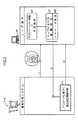
本発明の情報処理システムの実施形態について図面を用いて説明する。図1は本発明の一実施形態における情報処理システムの構成説明図であり、図2〜図5は本発明の一実施形態における情報処理システムの機能説明図である。
【0026】
図1に示す情報処理システムは、インターネットやイントラネット等のネットワークを介してユーザ端末20やその他外部端末(図示略)と双方向通信可能に接続されたサーバ10により構成されている。サーバ10は複数のサーバ(図示略)により構成されていてもよい。
【0027】
本発明の情報処理システムは、DB(データベース:情報管理手段)11と、マップ提供ユニット12と、情報取得ユニット13と、情報総合ユニット14と、情報提供ユニット15とを備えている。
【0028】
DB11は「マップ」、複数の「地区情報」及びその他種々の情報をデータとして管理する。
【0029】
マップ提供ユニット12は、DB11により管理されている「マップ」をネットワークを介してユーザ端末20に提供して表示させる。
【0030】
「マップ」は複数の「地区」、「商取引拠点」及び現存の拠点に帰属する地区より構成される現状の「商圏」を示す。「地区」には「大字」等の行政区画単位や、その他任意の区画単位が含まれる。「商取引拠点」には自動車等の商品を販売する自動車販売店等の店舗や、自動車修理等の役務を提供する自動車修理工場等の場所が含まれる。
【0031】
情報取得ユニット13は、ユーザ端末20に表示されるマップにおいてユーザにより仮想的に設定された「商圏」を特定する情報をユーザ端末20からネットワークを介して取得する。
【0032】
情報総合ユニット14は、仮想的な設定商圏を構成する地区の地区情報を総合して「総合地区情報」を作成する。
【0033】
「地区情報」には、各地区における「需要者」又は需要者により保有されている「商品」若しくは「役務に関する物品」の「数」、「分布」及び「密度」、及び特定のエンティティの市場占有率を表すパラメータが含まれている。また、地区情報は、サーバ10における人為的な情報入力操作や、サーバ10による外部からの情報収集により、逐次更新される。
【0034】
情報提供ユニット15は、「総合地区情報」をネットワークを介してユーザ端末20に提供し、「マップ」とともに表示させる。
【0035】
前記構成の本発明の情報処理システムの機能について図2〜図5を用いて説明する。
【0036】
まず、ユーザはその端末20において、所定のアプリケーションソフトを起動させた後、パスワードを入力する等の初期操作を実行する(図2s21)。
【0037】
これにより、サーバ10からユーザ端末20にマップmがダウンロードされ(マップ提供ユニット12によりネットワークを介してユーザ端末20にマップが提供され)(図2矢印▲1▼)、このユーザ端末20に図3に示すマップmが表示される。マップmには現存の商取引拠点(を表すアイコン)x1 、x2 、‥、拠点x1 、x2 、‥の商圏A1 、A2 、‥、及び商圏A1 、A2 、‥を構成する地区a1 、a2 、‥が示される。マップmの縮小、拡大、及び移動はユーザによる端末20の操作により任意に実行される。
【0038】
マップmには、複数のエンティティ(販売会社等)の拠点xi のほか、一の上位エンティティに属する複数の下位エンティティの拠点xi が、個々のエンティティに応じて相違するデザイン(形状、色彩等)を有するアイコンにより表示され得る。どのエンティティの拠点xi をマップmに表示させるかは、ユーザによる端末20の操作により選択され得る。
【0039】
商圏A1 、A2 、‥は、色彩及び模様、補助的に地区a1 同士の境界線、地区a2 同士の境界線、‥と異なる境界線(図3太線参照)により区分して表示される。どのエンティティの拠点xの商圏Aを表示させるかは、ユーザによる端末20の操作により選択され得る。
【0040】
地区ai は地区情報に応じた色彩及び模様により区分して表示され得る。また、地区ai として「大字」「市」「町」「村」「区」等の行政区画単位がユーザによる端末20の操作により変更設定され得る。
【0041】
ユーザがその端末20をマップmの地区ai をクリックする等の所定方法で操作することで、商圏A2 を構成する複数の地区a2 のうちの一部(図4(a)斜線部)を、仮想的に商圏A1 の一部とすることができる(図2s22)。また、ユーザは「拠点x1 の商品販売数」を「パラメータ」として指定する(図2s23)。このとき、現状の商圏A1 に、商圏A2 を構成する一部の地区a2 が追加されることで構成される「設定商圏A1 ’」及び「指定パラメータ」を特定する情報がユーザ端末20からサーバ10にアップロードされる(情報取得ユニット13により当該情報がユーザ端末20からネットワークを介して取得される)(図2矢印▲2▼)。
【0042】
また、図4(a)に格子縞で示す地区a1 は、指定パラメータである拠点x1 の商品販売数について、現状商圏A1 における上位5つの地区を表す(丸数字は順位を表す)。ユーザ端末20には、地区の色彩や模様と、地区情報の内容との対応関係を示す対応表(図示略)がマップmとともに示される。
【0043】
なお、現状の商圏A1 と同一の商圏が仮想的な商圏A1 ’として設定されてもよい。
【0044】
これに応じ、情報総合ユニット14が図4(b)に示す仮想商圏A1 ’において、地区情報である「拠点x1 の商品販売数」を表すパラメータについて、地区a1 ’の総合順位を付け、当該順位及び上位5つの地区a1 ’を特定する情報を「総合地区情報」として作成する。
【0045】
そして、「総合地区情報」がサーバ10からユーザ端末20にダウンロードされる(情報提供ユニット15によりネットワークを介してユーザ端末20に当該情報が提供される)(図2矢印▲3▼参照)。
【0046】
これにより、ユーザ端末20には図4(b)に示すように、拠点x1 の商品販売数について、仮想商圏A1 ’において上位5つの地区(格子縞部分)を他の地区と色彩や模様により区分して示すマップmが表示される。
【0047】
このとき、ユーザ端末20には、地区の色彩や模様と、地区情報の内容との対応関係を示す対応表(図示略)がマップmとともに示される。
【0048】
本システムによれば、ユーザはその端末20に表示されるマップmにおいて仮想的に商圏A1 ’を設定することで、当該設定商圏A1 ’について拠点x1 の商品販売数を表すパラメータについての地区a1 ’の順位(総合地区情報)を当該端末20を通じて取得することができる(図4(b)参照)。
【0049】
そして、ユーザは当該順位に基づき、現状商圏A1 と仮想的な設定商圏A1 ’とを比較し、当該設定商圏A1 ’が商取引の観点から適切か否かを検討し、実際にはどのように拠点x1 の商圏A1 を設定すべきかを判断することができる。
【0050】
具体的には、拠点x1 の商品販売数を表すパラメータについて、現状商圏A1 における上位5つの地区a1 (図4(a)格子縞部分参照)と、仮想商圏A1 ’における上位5つの地区a1 ’(図4(b)格子縞部分参照)は相違する。即ち、仮想的に商圏A1 に追加された商圏A2 の4つの地区a2 のうち2つが当該上位5つの地区a1 ’に含まれている。これは、当該2つの地区a2 は商圏A2 を構成するにも関わらず、拠点x1 の商品販売数が大きく、拠点x1 からすると商取引上重要な地区であると考えられる。
【0051】
従って、ユーザはかかる知見から現状商圏A1 及びA2 (図3参照)が、図5に示す形に変更されるのが商取引を促進させる上で適切であると判断することができる。なお、拠点x2 についても、商圏A2 を構成する各地区a2 の商取引上の重要性を考慮して最終的な判断がされるべきである。
【0052】
本実施形態では「拠点x1 の商品販売数」を表すパラメータについての順位が「総合地区情報」として作成されたが、他の実施形態として「需要者」又は需要者により保有されている「商品」若しくは「役務に関する物品」の「数」、「分布」及び「密度」、及び特定のエンティティの「市場占有率」を表すパラメータについて、設定商圏A1 ’(図4(b)参照)を構成する地区a1 ’の累計、平均、又は順位が「総合地区情報」として作成されてもよい。
【0053】
なお「需要者」とは商品購入等の履歴がある者、及び商品購入履歴は無いが将来的に商品を購入すると期待される未必的な需要者のうち一方又は両方を意味する。また「需要者」は商品又は役務の種類に鑑み、性別、年齢、職業等の属性に応じて適宜区分される。
【0054】
「商品」とは、販売者により販売された自動車等を意味する。また「役務に関する物品」とは、自動車修理や自動車洗浄等の役務の提供がされた自動車等を意味する。さらに「商品」又は「役務」は、エンティティの区分や、用品又は役務の種類等に応じて区分されていてもよい。
【0055】
当該他の実施形態によれば、特定の属性(18歳以上の就職男性)を有する需要者の数について、仮想商圏A’における累計が現状商圏Aにおける累計より低い場合、当該属性の需要者を主な対象とする商品(自動車等)の販売促進を図るという観点からして、少なくとも仮想商圏A’よりは現状商圏Aのほうが好ましいと判断され得る。またユーザに関係するエンティティ(提携メーカー等)の商品の市場占有率について、仮想商圏A’における平均が現状商圏Aにおける平均より低い場合、現状商圏Aよりは仮想商圏A’の方が当該エンティティの商品販売の余地が多いために好ましいと判断され得る。
【0056】
そして、ユーザはこれらの情報の総合勘案、及び検討に基づき、より適切な商圏設定を図ることができる。
【0057】
本発明の他の実施形態として、マップ提供ユニット12により「各拠点による地区ごとの需要者への商品販売数」という地区情報に応じ、一の拠点の商圏を構成する複数の地区のうち、該一の拠点による需要者への商品販売数が、他の拠点による需要者への商品販売数よりも小さい地区を、他の地区と区分して示すマップが、ネットワークを介してユーザ端末20に提供されてもよい。
【0058】
当該実施形態によれば、例えば拠点x1 の商圏A1 を構成する地区a1iにおいて、拠点x1 による商品販売数n(x1 ,a1i)が他の拠点x2 による商品販売数n(x2 ,a1i)よりも少なく、商圏A1 を構成する他の地区a1jにおいて、拠点x1 による商品販売数n(x1 ,a1j)が他の拠点x2 による需要者への商品販売数n(x2 ,a1j)よりも多い場合、ユーザ端末20のマップmにおいて地区a1iが地区a1jとは区分されて表示される(図4(a)参照)。
【0059】
ユーザはこのマップmを見ることで、現状では地区a1iは拠点x1 の商圏A1 を構成しているが、商品販売数の多い拠点x2 の商圏A2 を構成するように現状の商圏A1 及びA2 を変更したほうがよい等の事項を判断することができる。
【0060】
なお、商品に複数の種類がある場合、販売数は種類別の商品販売数が含まれている。
【0061】
本発明の他の実施形態として、マップ提供ユニット12により「各拠点による地区ごとの需要者への商品販売数」という地区情報に基づき、一の拠点の商圏を構成する複数の地区を「全拠点による需要者への商品販売数に対する該一の拠点による需要者への商品販売数の比率」という総合地区情報に応じ、区分して示すマップが、ユーザ端末20に提供されてもよい。
【0062】
当該他の実施形態によれば、例えば拠点x1 の商圏A1 を構成する地区a1 において、全拠点による商品販売数N(a1 )に対する拠点x1 による商品販売数n(x1 ,a1 )の比率の高低に応じ、ユーザ端末20のマップmにおいて各地区a1 が区分されて表示される(図4(a)参照)。
【0063】
ユーザはこのマップmを見ることで、現状では地区a1 は拠点x1 の商圏A1 を構成しているが、当該比率が低いので、他の拠点の商圏(例えば拠点x2 の商圏A2 )を構成するように商圏A1 を変更したほうがよい等の事項を判断することができる。
【図面の簡単な説明】
【図1】本発明の一実施形態における情報処理システムの構成説明図
【図2】本発明の一実施形態における情報処理システムの機能説明図
【図3】本発明の一実施形態における情報処理システムの機能説明図
【図4】本発明の一実施形態における情報処理システムの機能説明図
【図5】本発明の一実施形態における情報処理システムの機能説明図
【符号の説明】
10‥サーバ(情報処理システム)、11‥DB(情報管理手段)、12‥マップ提供ユニット、13‥情報取得ユニット、14‥情報総合ユニット、15‥情報提供ユニット、20‥ユーザ端末、m‥マップ、x1 、x2 ‥商取引拠点、A1 、A2 ‥商圏、a1 、a2 ‥地区[0001]
TECHNICAL FIELD OF THE INVENTION
The present invention relates to a system for processing information transmitted and received between a user terminal and a network.
[0002]
[Prior art]
How to set the trade area of a commercial base such as a store that provides services such as sales of automobiles and services such as automobile inspection is an important judgment item from the viewpoint of promotion of sales of products and the like. Further, when determining the setting of the commercial area of the commercial base, it is necessary to predict and determine the supply and demand of the products and the like at the commercial base, the influence of the setting of the commercial area on the commercial transaction, and the like. In addition, a great variety of information is required in large quantities as prediction and judgment materials for these matters.
[0003]
[Problems to be solved by the invention]
However, various and large amounts of information have become complicated, and it has been extremely difficult to determine how to set a trade area of a commercial transaction base.
[0004]
Therefore, an object of the present invention is to provide a system capable of providing information to a user in such a manner that the setting of a trade area of a commercial transaction base is facilitated.
[0005]
[Means for Solving the Problems]
An information processing system according to the present invention for solving the above-mentioned problem includes an information management means for managing a plurality of district information, and a plurality of districts and a district belonging to a commercial base by network communication with a user terminal. Map providing means for displaying a map indicating a trade area on the user terminal; and, when a trade area is virtually set by the user on the map displayed on the user terminal, the set trade area is set via network communication with the user terminal. Information provision means for preparing comprehensive district information by integrating the district information of the districts constituting the area, and information provision for providing the comprehensive district information created by the information comprehensive means to the user terminal via a network and displaying it together with a map Means.
[0006]
According to the present invention, the user can virtually set the trade area on the map displayed on the terminal, and thereby obtain “comprehensive area information” of the set trade area through the terminal. Here, in setting the trade area by the user, in addition to designating one or more districts that constitute a virtual new trade area, a district that constitutes a part of the current trade area is added as a part of another current trade area. And division as part of a virtual new trade area.
[0007]
Then, the user compares, for example, the current trade area with the virtual set trade area based on the “comprehensive area information” and examines whether or not the set trade area is appropriate from the viewpoint of commercial transactions. Can be determined.
[0008]
In addition, the present invention includes, in the district information, all or a part of the number, distribution and density of goods related to customers or goods or services held by the customers in the district, and the market share of a specific entity. According to the present invention, the information comprehensive means creates the total or average of the parameters of the districts constituting the business area set by the user or the rank of the districts according to the magnitude of the parameters as comprehensive district information.
[0009]
According to the present invention, the user can recognize, through the terminal, the “total area information”, such as the total or average of the parameters of the areas constituting the virtual set trade area. Since the parameters correspond to the market share of the specific entity, the user can easily determine whether the set trade area is appropriate in view of the market share in the current trade area through the comprehensive district information.
[0010]
Further, the present invention is characterized in that, when a parameter is specified by the user at the user terminal, the information totaling means creates comprehensive district information based on the specified parameter for the trade area set by the user via network communication with the user terminal. And
[0011]
ADVANTAGE OF THE INVENTION According to this invention, after specifying the parameter which a user considers important, the user can grasp | ascertain comprehensive district information based on the said parameter, and a more appropriate judgment based on a user's experience etc. is attained.
[0012]
Also, according to the present invention, the map providing means provides a user terminal via a network with a map which indicates a plurality of districts according to the district information or the comprehensive district information by color or pattern, or a combination thereof, and displays the map. It is characterized by making it.
[0013]
ADVANTAGE OF THE INVENTION According to this invention, a user can easily recognize visually what kind of district information or a district concerning comprehensive district information the district which comprises a commercial area is.
[0014]
In addition, according to the present invention, the map providing means may provide, according to the number of products sold to consumers in each district by each base as the district information, the demand by the one base among a plurality of districts constituting a trade area of the one base. A map in which a district where the number of products sold to a user is smaller than the number of products sold to a customer by another base is provided to the user terminal via a network, which is divided from the other districts.
[0015]
According to the present invention, the user, through the terminal, among a plurality of districts constituting the business area of a certain base, the number of products sold to the customer by the base is larger than the number of goods sold to the customer by the other base. Can recognize small districts. Then, based on this recognition, the user can determine whether or not the current commercial area of each base is appropriate.
[0016]
Specifically, the site in the district a 1i which constitute a trade area A 1 of x 1, base x items sales by 1 n (x 1, a 1i ) product sales number n (x 2 is due to other locations x 2, a 1i ), the number n (x 1 , a 1j ) of merchandise sold by the base x 1 in the other district a 1j constituting the business area A 1 is the number n of merchandise sold to the consumer by the other base x 2 If the number is larger than (x 2 , a 1j ), the area a 1i is displayed separately from the area a 1j on the map of the user terminal.
[0017]
The user is able to see this map, but at present the district a 1i constitute a trade area A 1 of the base x 1, trade area A of the current situation so as to constitute a trade area A 2 of items sold a large number of sites x 2 can be better to change the 1 and a 2 determines matters good like.
[0018]
When there are a plurality of types of products, the number of products sold means the number of sales of all or a part (for example, one type) of the plurality of types of products.
[0019]
Further, according to the present invention, the map providing means, based on the number of products sold to the customers in each district by each base as the district information, divides a plurality of districts constituting the business area of one base by all the bases as comprehensive district information. In accordance with the ratio of the number of goods sold to the customer by the one base to the number of goods sold to the customer, a map that is classified and provided to the user terminal via a network is characterized.
[0020]
According to the present invention, the user uses the map displayed on the terminal to, for each district, the ratio of the number of merchandise sold to a customer by a certain base to the number of merchandise sold to the consumer by all bases (comprehensive area information). Can be recognized. Then, based on this recognition, the user can determine whether or not the current trade area is appropriate.
[0021]
Specifically, in district a 1 constituting the trade area A 1 of the base x 1, the ratio of product sales number n by bases x 1 for all locations by product
[0022]
The user is watching this map, it is better but at present district a 1 constitutes a trade area A 1 of the base x 1, since the ratio is low, changing the commercial area so as to constitute a trade area of another base Items such as good can be determined.
[0023]
Further, the present invention is characterized in that the map providing means provides a user terminal with a correspondence table between the combination of the contents of the district information or the comprehensive district information and the color or pattern of the district or a combination thereof, and displays the table together with the map. And
[0024]
According to the present invention, the user can easily visually recognize, through a correspondence table displayed on the terminal, a correspondence relationship as to what kind of color and the like is attached to what kind of district information or general district information. can do.
[0025]
BEST MODE FOR CARRYING OUT THE INVENTION
An embodiment of an information processing system according to the present invention will be described with reference to the drawings. FIG. 1 is an explanatory diagram of a configuration of an information processing system according to an embodiment of the present invention, and FIGS. 2 to 5 are explanatory diagrams of functions of the information processing system according to an embodiment of the present invention.
[0026]
The information processing system shown in FIG. 1 includes a
[0027]
The information processing system of the present invention includes a DB (database: information management unit) 11, a
[0028]
The
[0029]
The
[0030]
The “map” indicates a current “trade area” composed of a plurality of “districts”, “commercial bases”, and districts belonging to existing bases. The “district” includes an administrative division unit such as “large” and other arbitrary division units. The “commerce base” includes a store such as an automobile dealer that sells products such as automobiles, and a place such as an automobile repair shop that provides services such as automobile repair.
[0031]
The
[0032]
The information
[0033]
"District information" includes the "number", "distribution" and "density" of "consumers" or "goods" or "service related goods" held by consumers in each district, and the market of specific entities. A parameter representing the occupancy is included. In addition, the district information is sequentially updated by an artificial information input operation on the
[0034]
The
[0035]
The function of the information processing system of the present invention having the above configuration will be described with reference to FIGS.
[0036]
First, the user starts predetermined application software on the terminal 20 and then performs an initial operation such as inputting a password (s21 in FIG. 2).
[0037]
As a result, the map m is downloaded from the
[0038]
The map m, other locations x i of a plurality of entities (sales companies, etc.), base x i of the plurality of sub-entities belonging to one of the higher-level entity, design (shape, color, etc. which are different depending on the individual entities ). Which display entity bases x i to map m may be selected by the operation of the terminal 20 by the user.
[0039]
Trade area A 1, A 2, ‥ it is color and pattern, supplementarily district a 1 between the border district a 2 between the borders, are presented separately by ‥ different boundary line (see FIG. 3 thick line) You. Which entity to display the business area A of the base x can be selected by the user operating the terminal 20.
[0040]
The districts ai can be displayed in different colors and patterns according to the district information. In addition, the administrative section units such as “large section”, “city”, “town”, “village”, and “ward” can be changed and set by the user's operation of the terminal 20 as the area ai .
[0041]
The user operates a predetermined method such as clicking the area a i of the map m and the terminal 20, a portion of the plurality of area a 2 constituting the trade area A 2 (FIGS. 4 (a) the hatched portion) and it may be part of virtually trade area a 1 (FIG 2s22). In addition, the user specifies a "product sales number of sites x 1" as the "Parameters" (Figure 2s23). At this time, information for specifying the “set trade area A 1 ′” and the “designated parameter” configured by adding a part of the district a 2 configuring the trade area A 2 to the current trade area A 1 is stored in the user terminal. 20 to the server 10 (the information is acquired by the
[0042]
Moreover, the district a 1 indicated by checkerboard in FIG. 4 (a), the product sales number for offices x 1 is the designated parameter, representative of the top five districts in current commercial area A 1 (the circled represent the order). On the
[0043]
Incidentally, the current state of the commercial area A 1 and the same trade area may be set as a virtual trade area A 1 '.
[0044]
In response, the information
[0045]
Then, the "comprehensive area information" is downloaded from the
[0046]
As a result, as shown in FIG. 4B, the
[0047]
At this time, on the
[0048]
According to the present system, the user virtually sets the trade area A 1 ′ in the map m displayed on the terminal 20, and sets a parameter for the parameter indicating the number of product sales at the base x 1 for the set trade area A 1 ′. The ranking (comprehensive district information) of the district a 1 ′ can be acquired through the terminal 20 (see FIG. 4B).
[0049]
The user based on the ranking, 'compared with the, the setting trade area A 1' and current trading areas A 1 virtual set trade area A 1 is examined whether it is appropriate from the viewpoint of commerce, actually what it can determine whether to set the trade area a 1 of the base x 1 as.
[0050]
Specifically, the parameter representing the number of items sold bases x 1, and the top five districts a 1 in current commercial area A 1 (FIGS. 4 (a) see checkerboard portion), top five districts in the virtual trading area A 1 ' a 1 ′ (see the grid pattern in FIG. 4B) is different. That is, two of virtually four district a 2 trade area A 2 that is added to the commercial area A 1 have been included in the top five districts a 1 '. This is the two districts a 2 despite constituting the trade area A 2, large items sales offices x 1, believed to be commerce important area to the base x 1.
[0051]
Therefore, the user can judge from this knowledge that changing the current trade areas A 1 and A 2 (see FIG. 3) to the form shown in FIG. 5 is appropriate for promoting commercial transactions. Here, also for the locations x 2, it should be the final decision in consideration of the importance of the commerce each district a 2 constituting the trade area A 2.
[0052]
In the present embodiment ranking of parameter representative of the "product sales locations x 1" was created as "general area information", "instruments held by the" consumer "or consumers as another embodiment "or" article concerning services "," number ", the" distribution "and" density ", and the parameter representative of the" market share "of a particular entity, configure settings trade area a 1 '(see FIG. 4 (b)) The total, average, or rank of the districts a 1 ′ to be created may be created as “general district information”.
[0053]
The “consumer” refers to one or both of a person who has a history of product purchase and the like and an unnecessary customer who has no product purchase history but is expected to purchase a product in the future. In addition, “consumers” are appropriately classified according to attributes such as gender, age, and occupation in view of the type of goods or services.
[0054]
"Commodity" means a car or the like sold by a seller. The “article related to services” means an automobile or the like provided with services such as car repair and car washing. Furthermore, “goods” or “services” may be classified according to the classification of the entity, the type of the article or the service, or the like.
[0055]
According to the other embodiment, for the number of consumers having a specific attribute (male who is 18 years old or older), if the cumulative total in the virtual commercial area A ′ is lower than the cumulative total in the current commercial area A, the consumer of the attribute is determined. From the viewpoint of promoting sales of a main target product (such as an automobile), it can be determined that the current trade area A is more preferable than at least the virtual trade area A ′. Also, regarding the market share of the product of the entity related to the user (such as an affiliated maker), if the average in the virtual trade area A ′ is lower than the average in the current trade area A, the virtual trade area A ′ is better than the current trade area A for the entity. It can be determined to be preferable because there is much room for product sales.
[0056]
Then, the user can set a more appropriate trade area based on comprehensive consideration and examination of the information.
[0057]
According to another embodiment of the present invention, the
[0058]
According to this embodiment, for example, bases in district a 1i which constitute a trade area A 1 of x 1, items sales n (x 1, a 1i) by site x 1 other locations x 2 by items sales n ( x 2 , a 1i ), and in the other district a 1j that constitutes the business area A 1 , the number n (x 1 , a 1j ) of products sold by the base x 1 is a product to the customer by the other base x 2. If sales n (x 2, a 1j) greater than, district a 1i in the map m of the
[0059]
The user is able to see this map m, but at present the district a 1i constitute a trade area A 1 of the base x 1, of the current situation so as to constitute a trade area A 2 of items sold a large number of sites x 2 trade area it is possible to determine the matter of good such as better to change a 1 and a 2.
[0060]
When there are a plurality of types of products, the number of sales includes the number of products sold by type.
[0061]
According to another embodiment of the present invention, a plurality of districts constituting a trade area of one base are set to “all bases” based on district information of “the number of products sold to consumers in each district by each base” by the
[0062]
According to the other embodiments, for example, bases in district a 1 constituting the trade area A 1 of x 1, items sales n by bases x 1 for all locations by product
[0063]
The user By looking at this map m, although at present the district a 1 constitutes a trade area A 1 of the base x 1, since the ratio is low, commercial area A 2 of the other base trade area (e.g. bases x 2 ) can be determined matters such should be revised trade area a 1 to constitute a.
[Brief description of the drawings]
FIG. 1 is an explanatory diagram of a configuration of an information processing system according to an embodiment of the present invention; FIG. 2 is an explanatory diagram of functions of an information processing system according to an embodiment of the present invention; FIG. FIG. 4 is a functional explanatory diagram of an information processing system according to an embodiment of the present invention. FIG. 5 is a functional explanatory diagram of an information processing system according to an embodiment of the present invention.
10 server (information processing system), 11 DB (information management means), 12 map providing unit, 13 information obtaining unit, 14 information comprehensive unit, 15 information providing unit, 20 user terminal, m map , x 1, x 2 ‥-commerce sites, A 1, A 2 ‥ trade area, a 1, a 2 ‥ district
Claims (7)
複数の地区情報を管理する情報管理手段と、
ユーザ端末とのネットワーク通信により、複数の地区、及び商取引拠点に帰属する地区より構成される商圏を示すマップを該ユーザ端末に表示させるマップ提供手段と、
ユーザ端末に表示されるマップにおいて、ユーザにより仮想的に商圏が設定されたとき、該ユーザ端末とのネットワーク通信を経て、該設定商圏を構成する地区の地区情報を総合して総合地区情報を作成する情報総合手段と、
情報総合手段により作成された総合地区情報をネットワークを介して該ユーザ端末に提供してマップとともに表示させる情報提供手段とを備えていることを特徴とする情報処理システム。A system for processing information transmitted to and received from a user terminal via a network,
An information management means for managing a plurality of district information;
Map providing means for displaying, on the user terminal, a map indicating a trade area composed of a plurality of districts and a district belonging to a commercial transaction base through network communication with the user terminal;
In a map displayed on the user terminal, when a commercial area is virtually set by the user, comprehensive area information is created by integrating the area information of the areas constituting the set commercial area via network communication with the user terminal. Information comprehensive means to
An information processing system, comprising: an information providing unit that provides the comprehensive area information created by the information integrating unit to the user terminal via a network and displays the information together with a map.
情報総合手段がユーザによる設定商圏を構成する地区のパラメータの累計若しくは平均、又はパラメータの大小による地区のランクを総合地区情報として作成することを特徴とする請求項1記載の情報処理システム。The district information includes parameters related to the number, distribution and density of goods relating to the customer or goods or services held by the customer in the district, and the market share of a particular entity, in whole or in part. ,
2. The information processing system according to claim 1, wherein the information comprehensive means creates, as the comprehensive district information, the total or average of the parameters of the districts constituting the trade area set by the user, or the rank of the district according to the magnitude of the parameters.
Priority Applications (1)
| Application Number | Priority Date | Filing Date | Title |
|---|---|---|---|
| JP2002319092A JP4011460B2 (en) | 2002-10-31 | 2002-10-31 | Information processing system |
Applications Claiming Priority (1)
| Application Number | Priority Date | Filing Date | Title |
|---|---|---|---|
| JP2002319092A JP4011460B2 (en) | 2002-10-31 | 2002-10-31 | Information processing system |
Publications (2)
| Publication Number | Publication Date |
|---|---|
| JP2004152186A true JP2004152186A (en) | 2004-05-27 |
| JP4011460B2 JP4011460B2 (en) | 2007-11-21 |
Family
ID=32462028
Family Applications (1)
| Application Number | Title | Priority Date | Filing Date |
|---|---|---|---|
| JP2002319092A Expired - Fee Related JP4011460B2 (en) | 2002-10-31 | 2002-10-31 | Information processing system |
Country Status (1)
| Country | Link |
|---|---|
| JP (1) | JP4011460B2 (en) |
Citations (3)
| Publication number | Priority date | Publication date | Assignee | Title |
|---|---|---|---|---|
| JPH10307868A (en) * | 1997-05-06 | 1998-11-17 | F M I:Kk | Commercial zone analysis information system |
| JPH11296539A (en) * | 1998-04-13 | 1999-10-29 | Omron Corp | Data processor |
| JP2002123787A (en) * | 2000-10-17 | 2002-04-26 | Kanebo Ltd | Store advice method |
-
2002
- 2002-10-31 JP JP2002319092A patent/JP4011460B2/en not_active Expired - Fee Related
Patent Citations (3)
| Publication number | Priority date | Publication date | Assignee | Title |
|---|---|---|---|---|
| JPH10307868A (en) * | 1997-05-06 | 1998-11-17 | F M I:Kk | Commercial zone analysis information system |
| JPH11296539A (en) * | 1998-04-13 | 1999-10-29 | Omron Corp | Data processor |
| JP2002123787A (en) * | 2000-10-17 | 2002-04-26 | Kanebo Ltd | Store advice method |
Also Published As
| Publication number | Publication date |
|---|---|
| JP4011460B2 (en) | 2007-11-21 |
Similar Documents
| Publication | Publication Date | Title |
|---|---|---|
| Vlachopoulou et al. | Geographic information systems in warehouse site selection decisions | |
| JP5580879B2 (en) | Travel price optimization (TPO) | |
| TW581957B (en) | Apparatus for merchandise price optimization and method therefor | |
| Sepasgozar et al. | Dissemination practices of construction sites’ technology vendors in technology exhibitions | |
| US20060265310A1 (en) | Realtime transparent commodity index and trading database | |
| Muller et al. | The geodemographics of restaurant development | |
| JP2004152186A (en) | Information processing system | |
| US20050278225A1 (en) | System and method for automated inventory management | |
| Curry | Single-source systems: Retail management present and future | |
| CN106537435A (en) | Statistical-data-generating server device, statistical-data generation system, and statistical-data generation method | |
| JP2010003080A (en) | Performance visual confirmation system | |
| CN114706575A (en) | Method and system for migrating and multiplexing data model | |
| CN112989227A (en) | Method and system for selecting target address of interested object | |
| Småros et al. | Using the assortment forecasting method to enable sales force involvement in forecasting: a case study | |
| Mattsson | Using Service Process Models to Improve Service Quality: Examples fromNew Zealand | |
| US20030149590A1 (en) | Warranty data visualisation system and method | |
| JP2004078454A (en) | Creating method of point of purchase advertisement | |
| KR101439361B1 (en) | An on-line market service system based on a virtual map and the method thereof | |
| CN107423996A (en) | Market Simulation device and networking Market Simulation device system | |
| KR20020037898A (en) | Supplier evaluation system using a network and operating method thereof | |
| RU101236U1 (en) | PRODUCT INFORMATION SERVICES SYSTEM FOR GOODS AND SERVICES | |
| JP2004152187A (en) | Information processing system | |
| JP2004078885A (en) | Method of printing point of purchase advertisement, and server for supporting creation of point of purchase advertisement | |
| Mazzetto | Visualization Approach To Forecasting Retail Business | |
| JP2000242690A (en) | Business strategy supporting system and machine- readable medium where program is recorded |
Legal Events
| Date | Code | Title | Description |
|---|---|---|---|
| A621 | Written request for application examination |
Free format text: JAPANESE INTERMEDIATE CODE: A621 Effective date: 20041202 |
|
| A131 | Notification of reasons for refusal |
Free format text: JAPANESE INTERMEDIATE CODE: A131 Effective date: 20070605 |
|
| A521 | Request for written amendment filed |
Free format text: JAPANESE INTERMEDIATE CODE: A523 Effective date: 20070723 |
|
| TRDD | Decision of grant or rejection written | ||
| A01 | Written decision to grant a patent or to grant a registration (utility model) |
Free format text: JAPANESE INTERMEDIATE CODE: A01 Effective date: 20070904 |
|
| A61 | First payment of annual fees (during grant procedure) |
Free format text: JAPANESE INTERMEDIATE CODE: A61 Effective date: 20070905 |
|
| R150 | Certificate of patent or registration of utility model |
Free format text: JAPANESE INTERMEDIATE CODE: R150 |
|
| FPAY | Renewal fee payment (event date is renewal date of database) |
Free format text: PAYMENT UNTIL: 20100914 Year of fee payment: 3 |
|
| FPAY | Renewal fee payment (event date is renewal date of database) |
Free format text: PAYMENT UNTIL: 20100914 Year of fee payment: 3 |
|
| FPAY | Renewal fee payment (event date is renewal date of database) |
Free format text: PAYMENT UNTIL: 20110914 Year of fee payment: 4 |
|
| FPAY | Renewal fee payment (event date is renewal date of database) |
Free format text: PAYMENT UNTIL: 20110914 Year of fee payment: 4 |
|
| FPAY | Renewal fee payment (event date is renewal date of database) |
Free format text: PAYMENT UNTIL: 20120914 Year of fee payment: 5 |
|
| FPAY | Renewal fee payment (event date is renewal date of database) |
Free format text: PAYMENT UNTIL: 20120914 Year of fee payment: 5 |
|
| FPAY | Renewal fee payment (event date is renewal date of database) |
Free format text: PAYMENT UNTIL: 20130914 Year of fee payment: 6 |
|
| FPAY | Renewal fee payment (event date is renewal date of database) |
Free format text: PAYMENT UNTIL: 20140914 Year of fee payment: 7 |
|
| LAPS | Cancellation because of no payment of annual fees |