EP4364483B1 - Erhöhung der zuverlässigkeit der ortung eines terminals basierend auf einem oder mehreren kennungen von nah gelegenen sendegeräten - Google Patents
Erhöhung der zuverlässigkeit der ortung eines terminals basierend auf einem oder mehreren kennungen von nah gelegenen sendegeräten Download PDFInfo
- Publication number
- EP4364483B1 EP4364483B1 EP22737812.2A EP22737812A EP4364483B1 EP 4364483 B1 EP4364483 B1 EP 4364483B1 EP 22737812 A EP22737812 A EP 22737812A EP 4364483 B1 EP4364483 B1 EP 4364483B1
- Authority
- EP
- European Patent Office
- Prior art keywords
- identifier
- terminal
- reliability
- server
- geolocation
- Prior art date
- Legal status (The legal status is an assumption and is not a legal conclusion. Google has not performed a legal analysis and makes no representation as to the accuracy of the status listed.)
- Active
Links
Images


Classifications
-
- H—ELECTRICITY
- H04—ELECTRIC COMMUNICATION TECHNIQUE
- H04W—WIRELESS COMMUNICATION NETWORKS
- H04W64/00—Locating users or terminals or network equipment for network management purposes, e.g. mobility management
-
- G—PHYSICS
- G01—MEASURING; TESTING
- G01S—RADIO DIRECTION-FINDING; RADIO NAVIGATION; DETERMINING DISTANCE OR VELOCITY BY USE OF RADIO WAVES; LOCATING OR PRESENCE-DETECTING BY USE OF THE REFLECTION OR RERADIATION OF RADIO WAVES; ANALOGOUS ARRANGEMENTS USING OTHER WAVES
- G01S5/00—Position-fixing by co-ordinating two or more direction or position line determinations; Position-fixing by co-ordinating two or more distance determinations
- G01S5/02—Position-fixing by co-ordinating two or more direction or position line determinations; Position-fixing by co-ordinating two or more distance determinations using radio waves
- G01S5/0205—Details
- G01S5/0244—Accuracy or reliability of position solution or of measurements contributing thereto
-
- G—PHYSICS
- G01—MEASURING; TESTING
- G01S—RADIO DIRECTION-FINDING; RADIO NAVIGATION; DETERMINING DISTANCE OR VELOCITY BY USE OF RADIO WAVES; LOCATING OR PRESENCE-DETECTING BY USE OF THE REFLECTION OR RERADIATION OF RADIO WAVES; ANALOGOUS ARRANGEMENTS USING OTHER WAVES
- G01S5/00—Position-fixing by co-ordinating two or more direction or position line determinations; Position-fixing by co-ordinating two or more distance determinations
- G01S5/02—Position-fixing by co-ordinating two or more direction or position line determinations; Position-fixing by co-ordinating two or more distance determinations using radio waves
- G01S5/0252—Radio frequency fingerprinting
- G01S5/02529—Radio frequency fingerprinting not involving signal parameters, i.e. only involving identifiers
-
- G—PHYSICS
- G06—COMPUTING OR CALCULATING; COUNTING
- G06F—ELECTRIC DIGITAL DATA PROCESSING
- G06F16/00—Information retrieval; Database structures therefor; File system structures therefor
- G06F16/20—Information retrieval; Database structures therefor; File system structures therefor of structured data, e.g. relational data
- G06F16/29—Geographical information databases
Definitions
- the present invention belongs to the field of geolocation of a terminal of a wireless communication system.
- the geolocation of the terminal is implemented from one or more identifiers of neighboring transmitting devices detected by the terminal and using a geolocation server comprising a database making the association between transmitting devices and their geographical position.
- a terminal detects, for at least one transmitting device, an identifier of the transmitting device from a message transmitted by the transmitting device, for example on a beacon signal.
- the terminal then sends a query message to a geolocation server.
- the query message includes the identifier of the transmitting device.
- the geolocation server includes a geolocation database associating identifiers of transmitting devices with their respective geographical positions.
- the geolocation server can then determine the geographical position associated with said transmitting device, then send this information to the terminal in a response message.
- the geographical position of the transmitting device corresponds to an estimated geographical position of the terminal.
- the geographical position of the terminal may optionally be refined based on a power level with which the beacon signal is received by the terminal. It is also possible to estimate the geographical position of the terminal based on the geographical position of several different transmitting devices from which the terminal has received the beacon signal at a given time.
- the geographic location of a transmitting device may, however, change over time. When this happens, the geolocation database must be updated so that the association between the identifier and the geographic location of the transmitting device remains correct. If the association between the identifier and the geographic position of the transmitting device is not correct in the geolocation database, then an estimate of the terminal's geographic position based on said identifier is distorted.
- Geolocation database update campaigns are particularly costly, and the frequency with which they are carried out is sometimes insufficient to guarantee satisfactory reliability in the geolocation of a terminal. In addition, these update campaigns are rarely exhaustive.
- the geolocation database may make the association between said identifier and only one of said two geographical positions. This association will be correct in certain use cases, in particular for terminals that are within range of the transmitting device whose geographical position is that stored in the geolocation database. This association will however be incorrect in other use cases, in particular for terminals that are within range of the other transmitting device whose geographical position is not stored in the geolocation database. Depending on the case, an estimate of the geographical position of the terminal based on said identifier may be distorted.
- the patent application US2011/250903 shows a method of geolocating a terminal based on identifiers and having reliability information.
- the present invention aims to remedy all or part of the drawbacks of the prior art, in particular those set out above, by proposing a solution for making the geolocation of a terminal more reliable from one or more identifiers of neighboring transmitting devices.
- the expression "geographic position" of an object may correspond, broadly, to position information representative of the exact geographical position of said object. Thus, it may directly involve the coordinates (longitude, latitude and possibly altitude) of a geographical position, but it may also involve contextual information making it possible to estimate the exact geographical position of the object (such as, for example, a postal address, a store name, a name of a district, region or country, etc.).
- the invention is based on the fact that a database separate from the geolocation database provides information on a reliability value associated with each of the identifiers detected by the terminal.
- a reliability value is associated with an identifier and a geolocation server.
- the reliability value represents the confidence that can be placed in this identifier to be able to precisely geolocate the terminal using this identifier with said geolocation server.
- the identifier reliability database can be built to provide information on the reliability of identifiers relative to a single geolocation server, or relative to several different geolocation servers.
- an identifier's reliability value can also be weighted based on additional criteria, such as a service cost of the associated geolocation server.
- the reliability values can make it possible to select the geolocation server that seems the most reliable for geolocating the terminal from among a plurality of geolocation servers. This selection can even take place using reliability values associated with identifiers that are different from the identifiers detected by the terminal.
- the term “any identifier” must be understood as being able to correspond both to an identifier included in the set of identifiers detected and returned by the terminal that one seeks to geolocate, and to an identifier that is not part of this set of identifiers detected and returned by the terminal.
- the reliability database is used to determine which geolocation server to use and/or to select which identifiers should be included in the request (i.e. to define the recipient and/or the content of the request).
- the invention may further comprise one or more of the following characteristics, taken individually or in any technically possible combination.
- the reliability value of each identifier among the received identifiers is compared to a threshold value to determine whether or not the identifier should be used for estimating the geographic position of the terminal using the geolocation server.
- a predetermined maximum number of identifiers among the received identifiers having the best reliability values are used for estimating the geographical position of the terminal using the geolocation server.
- the method further comprises, when none of the identifiers received has a satisfactory reliability value, an estimation of an approximate geographical position of the terminal without the aid of the geolocation server.
- the identifier reliability database comprises, for said at least one of the identifiers received, an approximate geographical position of the transmitting device carrying said identifier, said approximate geographical position having been previously determined without the aid of the geolocation server. The estimation of the approximate geographical position of the terminal is then carried out as a function of the approximate geographical position associated with said identifier.
- said at least one of the received identifiers is associated, in the identifier reliability database, with several reliability values each associated with a different value of discrimination information (the term “discrimination key” could also be used instead of the term “discrimination information”, while having the same meaning).
- a value of the discrimination information is determined by the access network from said at least one message received from the terminal, and the geolocation method comprises, for said at least one of the identifiers received, obtaining a reliability value to be taken into account for the estimation of the geographical position of the terminal from said value of the discrimination information.
- the discrimination information makes it possible to identify a geolocation server
- the geolocation method comprises a selection of the geolocation server to be used for the estimation of the geographic position of the terminal based on the different reliability values of said at least one of the identifiers received.
- the first wireless communication protocol is a communication protocol of a wireless wide area network or a low-power wireless wide area network
- the second wireless communication protocol is a communication protocol of a wireless local area network, a communication protocol of a wireless personal area network or a short-range communication protocol.
- the invention may further comprise one or more of the following characteristics, taken individually or in any technically possible combination.
- the consistency check includes a calculation of a distance between the approximate geographic position of the terminal and the geographic position associated with said identifier in the geolocation database.
- the update includes a calculation of a new reliability value based on a distance between the approximate geographic position of the terminal and the geographic position associated with said identifier in the geolocation database.
- the new reliability value is further calculated based on a reliability value previously assigned to said identifier in the identifier reliability database.
- the identifier reliability database includes, for said identifier, a date of last update of the reliability value, and the new reliability value is further calculated based on a current date and the date of last update of the reliability value of said identifier.
- the updating method further comprises determining an approximate geographic position of the transmitting device carrying said identifier, without the aid of the geolocation server, and associating said approximate geographic position of the transmitting device with said identifier in the identifier reliability database.
- the server is configured to implement any of the previously described implementation modes of the geolocation method, and/or any of the previously described implementation modes of the method for updating the reliability database of the identifiers.
- the server may further comprise one or more of the following characteristics, taken individually or in all technically possible combinations.
- the server is further configured, when none of the received identifiers has a satisfactory reliability value, to estimate an approximate geographic position of the terminal without the aid of the geolocation server.
- the server is further configured to estimate the approximate geographic position of the terminal from, for at least one of the identifiers received, an approximate geographic position of the transmitting device carrying said identifier, said approximate geographic position of the transmitting device having been previously determined by the server without the aid of the geolocation server and stored in the identifier reliability database.
- said at least one of the identifiers received is associated, in the identifier reliability database, with several reliability values each associated with a different value of discrimination information making it possible to identify a geolocation server, and said server is further configured to select, based on the different reliability values associated with said identifier, the geolocation server to be used to estimate the geographical position of the terminal.
- the server is further configured to calculate, for at least one of the identifiers received, a new reliability value based on a distance between the approximate geographic position of the terminal and the geographic position associated with said identifier in the geolocation database.
- the present invention relates to an access network comprising an access network server according to any one of the modes of previous achievements.
- said access network is a wireless wide area network or a low-power wireless wide area network.
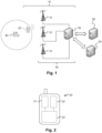
- FIG. 1 schematically represents a wireless communication system 10, comprising at least one terminal 20 and an access network 30 comprising several base stations 31.
- the terminal 20 is adapted to transmit messages on an uplink to the access network 30.
- Each base station 31 is adapted to receive the messages from the terminal 20 when said terminal is within its range.
- a message sent by the terminal 20 includes an identifier of the terminal 20.
- Each message received by a base station is for example transmitted to a server 32 of the access network 30, possibly accompanied by other information such as an identifier of the base station 31 which received it, the reception power level of said received message, the time of arrival of said message, the frequency at which the message was received, etc.
- the server 32 processes for example all of the messages received from the different base stations 31.
- the wireless communication system 10 may be unidirectional, that is to say that it only allows message exchanges on the uplink from the terminal 20 to the access network 30. However, nothing precludes, according to other examples, allowing bidirectional exchanges.
- the access network 30 is also adapted to transmit, via the base stations 31, messages on a downlink to the terminal 20, which is adapted to receive them.
- the message exchanges on the uplink to the access network 30 use a first wireless communication protocol.
- the first wireless communication protocol is a wireless wide area network (WWAN) communication protocol.
- WWAN wireless wide area network
- the first wireless communication protocol is a standardized communication protocol of the UMTS (Universal Mobile Telecommunications System), LTE (Long Term Evolution), LTE-Advanced Pro, 5G, etc. type.
- the first wireless communication protocol is a low-power wireless wide area network (LPWAN) communication protocol.
- LPWAN wireless wide area network
- Such a wireless communication system is a long-range access network (greater than one kilometer, or even greater than a few tens of kilometers), with low power consumption (for example, power consumption during the transmission or reception of a message of less than 100 mW, or even less than 50 mW, or even less than 25 mW), and whose data rates are generally less than 1 Mbps.
- Examples of LPWAN networks include Sigfox, LoRaWAN, Ingenu, Amazon Sidewalk, Helium, etc.
- Such wireless communication systems are particularly suitable for loT or M2M applications.
- data exchanges are essentially unidirectional, in this case on an uplink from the terminals 20 to the access network 30 of the wireless communication system 10.
- the Access network planning is often carried out such that a given geographical area is covered simultaneously by several base stations 31, such that a message transmitted by a transmitting device 20 can be received by several base stations 31.
- the first wireless communication protocol is a low-power, ultra-narrowband wireless wide area network communication protocol.
- ultra narrow band (“Ultra Narrow Band” or UNB in the English literature) we mean that the instantaneous frequency spectrum of the radio signals emitted by the terminals has a frequency width of less than two kilohertz, or even less than one kilohertz.
- the terminal 20 is also adapted to receive messages transmitted by at least one transmitting device 40, which is located in the vicinity of said terminal 20.
- the messages transmitted by the transmitting device 40 use a second wireless communication protocol, different from the first wireless communication protocol.
- the transmitting device 40 can be entirely independent of the wireless communication system 10, and it does not need to support the first wireless communication protocol.
- the second wireless communication protocol has a shorter range than the range of the first wireless communication protocol.
- the geographic position of the transmitting device 40 within the range of which the terminal 20 is located, provides more precise information on the geographic position of the terminal 20 than, for example, the geographic position of a base station 31 which receives a message transmitted by the terminal 20.
- the second wireless communication protocol is for example a wireless local area network communication protocol (“Wireless Local Area Network” or WLAN in the English literature), for example of the WiFi type (IEEE 802.11 standards), etc., or a wireless personal area network communication protocol (“Wireless Personal Area Network” or WPAN in the English literature), for example of the Bluetooth or BLE type (English acronym for “Bluetooth Low Energy”, “Bluetooth à basse réelle” in French), etc.
- the second wireless communication protocol may be a short-distance communication protocol based for example on NFC technology (English acronym for “Near Field Communication”). Communication, "near field communication” in French) or on RFID technology (acronym for "Radio Frequency Identification”).
- a geolocation server 50 comprises a database, called a “geolocation database”, comprising a table storing identifiers of transmitter devices 40. Each transmitter device identifier 40 is associated in the table with at least one item of position information representative of the geographical position of the transmitter device 40.
- An identifier of a transmitting device 40 corresponds for example to a MAC address of the transmitting device 40 (MAC is the acronym for “Media Access Control”).
- MAC is the acronym for “Media Access Control”.
- Other parameters could however play the role of identifier for a transmitting device 40, such as for example an SSID (an acronym for “Service Set IDentifier”) or a BSSID (an acronym for “Base Service Set IDentifier”) of a WiFi access point, an identifier of a Bluetooth or BLE access point, an identifier of an RFID tag, etc.
- the position information may be directly coordinates (longitude, latitude and possibly altitude) of a geographical position of the transmitting device 40.
- the position information may however also be contextual information making it possible to estimate the geographical position of the transmitting device 40, such as for example a postal address, a store name, a name of a district, region or country, etc.
- the geolocation server 50 is for example connected to the server 32 of the access network 30 by an internet connection.
- geolocation servers 50 are available. These different geolocation servers can for example be operated by different providers of a geolocation service.
- FIG. 2 schematically represents an example of the embodiment of a terminal 20.
- the terminal 20 comprises a first communication module 21 adapted to exchange messages with the base stations 31 according to the first wireless communication protocol.
- the first communication module 21 is for example in the form of a radio circuit comprising equipment (antenna, amplifier, local oscillator, mixer, analog filter, etc.).
- the terminal 20 also comprises a second communication module 22 adapted to receive messages transmitted by the transmitting device of interest 40, according to the second wireless communication protocol.
- the second communication module 22 is for example in the form of a radio electric circuit comprising equipment (antenna, amplifier, local oscillator, mixer, analog filter, etc.).
- the terminal 20 also comprises a processing circuit 23, connected to the first communication module 21 and to the second communication module 22.
- the processing circuit 23 comprises, for example, one or more processors and storage means (magnetic hard disk, electronic memory, optical disk, etc.) in which a computer program product is stored, in the form of a set of program code instructions to be executed to implement all or part of the steps of a method for geolocating the terminal (see below).
- the server 32 of the access network 30 also comprises one or more processors and storage means in which a computer program product is stored, in the form of a set of program code instructions to be executed to implement all or part of the steps of a method for geolocating the terminal and/or a method for updating an identifier reliability database (see below).
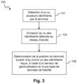
- FIG. 3 schematically represents the main steps of a method 100 according to the invention for geolocating a terminal 20.
- the method 100 comprises a step of detection 101, by the terminal 20, for at least one transmitting device 40, of an identifier of the transmitting device 40 from a message transmitted by the transmitting device 40 according to the second wireless communication protocol.
- the method 100 then comprises a step 102 of transmission, by the terminal 20, to the access network 30, and according to the first wireless communication protocol, of at least one message comprising the identifier(s) detected in step 101.
- a detected identifier can be transmitted in a single message or in several messages (each message then comprising a portion of said identifier).
- a single message may possibly contain several identifiers.
- the method 100 then comprises a step 106 of determining, by the access network 30, a geographical position of the terminal 20, from at least one of the identifiers received, and using a database, called “identifier reliability database” and a geolocation server 50.
- This step of determination 106 includes in particular the sending of a request comprising at least one of the identifiers received at the geolocation server 50.
- the credential reliability database allows you to associate a reliability value with an identifier.
- the reliability value represents the confidence that can be placed in this identifier to be able to precisely geolocate the terminal using this identifier with the geolocation server.
- the credential reliability database can be constructed to provide information on credential reliability relative to a single geolocation server, or relative to several different geolocation servers. When there are several different geolocation servers, each reliability value is further associated with a particular geolocation server.
- the identifier reliability database may allow filtering of the identifiers to be taken into account in estimating the geographical position of the terminal using the geolocation server 50, based on the reliability values of the identifiers received. For example, a low reliability value is assigned in the reliability database to identifiers for which the geographical position associated in the geolocation database is deemed erroneous; identifiers with too low a reliability value will not be taken into account for estimating the geographical position of the terminal.
- the reliability values can make it possible to select the geolocation server which seems the most reliable for geolocating the terminal from among a plurality of geolocation servers.
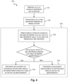
- FIG. 4 presents as an example a particular mode of implementation of the geolocation method 100 described above with reference to the Figure 3 .
- the particular mode of implementation described in the Figure 4 allows you to filter the identifiers to be taken into account in estimating the geographical position of the terminal using the geolocation server 50.
- the method 100 repeats the steps 101 and 102 previously described with reference to the Figure 3 .
- the method 100 then comprises a step 103 of determining, for each identifier received, a reliability value.
- the reliability value is representative of a confidence granted to the identifier for geolocating the terminal 20 with the geolocation server 50.
- the reliability value is determined using a database, called the “identifier reliability database”.
- identifier reliability database is stored by one or more servers separate from the geolocation server 50.
- the identifier reliability database may be stored by the server 32 of the access network 30.
- the identifier reliability database could, however, also be shared between several servers belonging to the access network 30.
- the identifier reliability database could be stored by one or more third-party servers connected to the access network 30 but managed by an operator other than the operator who manages the access network 30.
- the credential reliability database allows a credential to be assigned a reliability value.
- a reliability value for example, is a value (a score) between zero and one. The closer an credential's reliability value is to one, the more reliable the geographic location of the issuing device associated with the credential in the geolocation database can be considered. Conversely, the closer an credential's reliability value is to zero, the more likely it is that the geographic location of the issuing device associated with the credential in the geolocation database is incorrect.
- the credential reliability database is a list of credential values that have been determined to be sufficiently reliable. If an credential is not in the credential reliability database, then it can be assigned a reliability value of zero. If an credential is in the credential reliability database, then it can be assigned a reliability value of one.
- the credential reliability database is a list of credential values that have not been determined to be sufficiently reliable. If an credential is not in the credential reliability database, then it can be assigned a reliability value of one. If an credential is in the credential reliability database, then it can be assigned a reliability value of zero.
- the method 100 comprises a step 104 of estimating a geographical position of the terminal 20, as a function of the reliability values thus determined, and using the geolocation server 50.
- the reliability value of each received identifier is compared to a threshold value to determine whether or not the identifier must be used for the estimation 104 of the geographic position of the terminal 20 using the geolocation server 50.
- a predetermined maximum number of identifiers having the greatest reliability values are used for the estimation 104 of the geographic position of the terminal 20 using the geolocation server 50.
- Such provisions make it possible to filter the identifiers to be taken into account in estimating the geographical position of the terminal using the geolocation database (i.e. to filter the identifiers to be included in the request to be sent to the geolocation server 50), according to the reliability values of the identifiers. For example, if a low reliability value is assigned in the reliability database to the identifiers for which the geographical position associated in the geolocation database is deemed erroneous, it then becomes possible to favor the identifiers which have a high reliability value.
- steps 103 and 104 are implemented by the server 32 of the access network 30. It should however be noted that, in a variant, nothing would prevent these steps from being implemented by a third-party server, for example a third-party server which hosts the identifier reliability database. However, this is the case where the server(s) which store the identifier reliability database are separate from the geolocation server 50. This allows the operator of the identifier reliability database to maintain its database without depending on the operator of the geolocation server 50. Furthermore, these servers may contain information which is not known by the geolocation server 50 (this may for example be private information known only to the access network 30 and which must not be communicated to the geolocation server 50).
- the server 32 of the access network 30 sends to the geolocation server 50 the identifier(s) deemed sufficiently reliable, and the geolocation server 50 estimates the position of the terminal 20 from the positions geographical positions associated with the different identifiers in the geolocation database.
- the geolocation server 50 simply returns the geographical position associated with each identifier in the geolocation database, and it is the server 32 which estimates the position of the terminal 20 from the geographical positions associated with the different identifiers.
- the method 100 comprises a step 105 of estimating an approximate geographical position of the terminal 20 without the aid of the geolocation server 50.
- This step is for example implemented by the server 32 of the access network 30. It should however be noted that, in a variant, this step could also be implemented by a third-party server, for example a third-party server which hosts the reliability database of the identifiers. It should also be noted that this step is optional (it would be possible to consider that no position of the terminal 20 can be determined reliably when none of the received identifiers has a satisfactory reliability value).
- the approximate geographical position of the terminal 20 may correspond to coordinates (longitude, latitude and possibly altitude) of an estimated position of the terminal 20, with possibly an indication of the accuracy of this estimated position.
- This may however also be contextual information making it possible to estimate the position of the terminal 20, such as for example a postal address, a store name, a name of a district, region or country, etc.
- This contextual information may in particular be determined directly from one or more parameters contained in the message sent by the terminal 20 and/or from information available within the access network associated with the terminal 20 which sent the message and derived from said message. For example, it is possible to determine in which region or in which country the terminal 20 is located from an identifier of the terminal 20 if the access network 30 is aware that this terminal belongs to a client company which only operates in a particular region or country.
- the access network 30 is for example configured to estimate an approximate geographical position of the terminal 20 based on messages received from said terminal 20.
- the approximate geographical position is estimated from the message received comprising the identifier of the transmitting device 40.
- the access network 30 may estimate the approximate geographic position of the terminal 20 as being the geographic position of a base station 31 that has received a message transmitted by the terminal 20. If several base stations 31 can receive a message transmitted by the terminal 20, it is possible to estimate the approximate geographic position of the terminal 20 based on the geographic positions of all the base stations 31 that have received the message transmitted by the terminal 20 (for example by defining a barycenter of these geographic positions).
- the access network 30 can estimate the distances which separate the terminal 20 from one or more base stations 31 by calculating the propagation time of a message transmitted by the terminal 20 to the base stations 31 from the TOA measurements or from measurements of differences in arrival times (“Time Difference of Arrival” or TDOA in the English literature) of this message at the different base stations 31. It is then possible to estimate the position of the terminal 20 by multilateration if the geographical positions of the base stations 31 are known.
- the method for estimating an approximate geographical position of the terminal 20 by the access network 30 may be based on machine learning techniques which associate a radio fingerprint with a geographical position of the geographical area considered.
- Such a method is based on the assumption that a reception power level by a base station 31 for a message transmitted by the terminal 20 located at a given geographical position is stable over time. Concretely, this involves constructing, during a first calibration phase, a database which associates with known geographical positions a “radio signature” corresponding to all the RSSI measurements obtained for a terminal 20 at the geographical position considered for a set of base stations 31.
- a radio signature observed for the terminal 20 for which we seek to estimate the approximate geographical position is compared to all the radio signatures in the database in order to estimate the approximate geographical position of the terminal 20 from the position(s) geographic location(s) corresponding to the radio signature(s) most similar to the radio signature of terminal 20.
- the estimation of the approximate geographical position of the terminal 20 is carried out by the access network 30 without explicit information contributing to this estimation being sent by the terminal in a message to the access network (in other words, the terminal does not transmit to the access network messages whose binary data include information making it possible to estimate the geographical position of the terminal).
- Such provisions make it possible to limit the quantity of data exchanged between the terminal and the access network to geolocate the terminal 20.
- an approximate geographic position may be assigned to a transmitting device 40 in the identifier reliability database.
- This approximate geographic position of the transmitting device 40 may have been previously determined without the aid of the geolocation server 50.
- This approximate geographic position of the transmitting device 40 may correspond, for example, to an approximate geographic position, estimated by the access network 30, of a terminal 20 which has previously sent a message comprising the identifier of said transmitting device 40.
- the approximate geographic position may also be estimated by the access network 30 from the estimated positions of several terminals 20 which have previously sent a message comprising the identifier of said transmitting device 40. It is thus possible to implement a smoothing over time of the estimated positions of the terminals which have detected and transmitted this identifier (median, weighted average, exponential smoothing, etc.).
- identifier reliability database a position of an emitting device 40 provided by the geolocation database. It is nevertheless advantageous to store an approximate geographical position of an emitting device 40 in the identifier reliability database, to subsequently help geolocate a terminal 20 which detects this identifier, in the event that the position associated with this identifier in the geolocation database is not reliable.
- the identifier reliability database comprises, for at least one of the identifiers received, an approximate geographical position of the transmitting device 40 carrying said identifier (said approximate geographical position having been previously determined without the aid of the geolocation server 50), and the approximate geographical position of the terminal 20 is estimated at step 105 based on the approximate geographic position associated with said identifier.
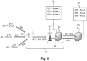
- FIG. 5 illustrates an example of implementation of the geolocation method 100 according to the invention.
- a terminal 20 detects (in step 101) three transmitting devices 40 associated respectively with the identifiers ID1, ID2, and ID3. Each identifier is detected on a beacon signal transmitted respectively by each transmitting device 40 according to the second wireless communication protocol.
- the terminal 20 then transmits (in step 102) a message comprising the detected identifiers ID1, ID2, and ID3. This message is transmitted to the access network 30 according to the first wireless communication protocol.
- a server 32 of the access network 30 determines (in step 103), for each identifier received, a reliability value in an identifier reliability database 33.
- the identifier reliability database 33 is stored by the server 32. This identifier reliability database 33 associates a score (Score1, Score2, Score3, ...) with each identifier (ID1, ID2, ID3, ).
- a geolocation server 50 separate from the server 32 stores a geolocation database 51 associating identifiers (ID1, ID2, ID3, etc.) and the geographic position (pos1, pos2, pos3, etc.) respectively associated with each identifier.
- the scores of the identifier reliability database correspond to values between zero and one, and the higher the value of a score associated with an identifier, the more reliable the reliability of the geographic position associated with said identifier in the geolocation database 51 is deemed to be.
- the score Score2 associated with the identifier ID2 has a low value, for example 0.2. This means that the position pos2 associated with the identifier ID2 in the geolocation database 51 is considered erroneous. It is also considered, for example, that the scores Score1 and Score3 are respectively equal to 0.8 and 0.9. This means that the positions pos1 and pos3 associated respectively with the identifiers ID1 and ID3 in the geolocation database 51 are considered correct.
- the server 32 sends a request comprising only the identifiers ID1 and ID3 to the geolocation server 50 to estimate the position of the terminal 20.
- a geographic position of the terminal 20 (pos) is then estimated (in step 104), from the identifiers ID1 and ID3 which have been selected according to the reliability values, and using the geolocation server 50.
- the position pos is determined by the geolocation server 50.
- the geolocation server 50 could have returned the positions pos1 and pos3 associated respectively with the identifiers ID1 and ID3, and the server 32 could then have determined a geographic position of the terminal 20 from the positions pos1 and pos3 (for example by calculating a barycenter of the positions pos1 and pos3).
- the position of terminal 20 estimated from positions pos1 and pos3 of identifiers ID1 and ID3 is more reliable and more precise than a position which would be determined by also taking into account position pos2 of identifier ID2 (since this position pos2 is incorrect).
- the structure of the 33 credential reliability database illustrated in Figure 5 is quite basic since it simply associates a reliability value with an identifier. However, it is possible to associate other information with each identifier stored in the identifier reliability database 33.
- an identifier may be associated, in the identifier reliability database 33, with several reliability values each associated with a different value of discrimination information.
- the geolocation method 100 may then comprise additional steps of determining a value of the discrimination information for the terminal 20 from the message received, and of obtaining, for at least one of the identifiers received, a reliability value to be taken into account for the estimation 104 of the geographical position of the terminal 20. This involves, for example, selecting a reliability value from among the different reliability values available for said identifier (this selection is made as a function of the value of the discrimination information determined). According to another example, the reliability value to be taken into account for an identifier may be obtained via a calculation based on several reliability values.
- the discrimination information may correspond to information representative of a group of terminals to which the terminal 20 belongs (such as for example the name of the client company to which the terminal 20 belongs, a type of device corresponding to the terminal 20, etc.).
- the discrimination information may also correspond to a geographical area in which the terminal 20 is located. It may happen that two transmitting devices 40 sharing the same identifier are located at two geographical positions very far from each other, and that only one of the two geographical positions is associated with said identifier in the geolocation database 51.
- the identifier reliability database 33 may then associate a high reliability value with said identifier for a terminal 20 which is located in a geographical area which also includes the transmitting device whose position is stored in the geolocation database 51.
- the identifier reliability database 33 may associate a low reliability value with said identifier for a terminal 20 which is located in a geographical area which includes the transmitting device whose position is the one which is not stored in the geolocation database 51.
- the use of discrimination information can then make it possible to know whether the identifier in question must be used or not in the estimation 104 of the geographical position of the terminal 20.
- the discrimination information may also correspond to information representative of at least one other transmitter device identifier 40 detected by the terminal 20. Indeed, transmitter devices 40 which are geographically close to each other are generally detected simultaneously by a terminal 20. This information may make it possible to select a reliability value to be taken into account for a given identifier: for example, if two transmitter devices share the same identifier, but if only one of these two transmitter devices has already been detected simultaneously with another transmitter device indicated in the message sent by the terminal 20, then it is possible to assign to said identifier, in the reliability database 33, a first reliability value when the other identifier is also detected, and a second reliability value when the other identifier is not detected.
- the discrimination information makes it possible to identify a geolocation server 50 (for example via an internet address of the server, a domain name, a name of the operator who manages the server, etc.).
- the geolocation method 100 can then comprise a selection step of the geolocation server 50 to be used (among the different geolocation servers available) for the estimation 104 of the geographical position of the terminal 20. This selection is made according to the different reliability values associated with at least one of the identifiers received. This selection makes it possible to define the recipient of the request which is sent to a geolocation server to estimate the position of the terminal.
- the identifier reliability database 33 may then associate a low reliability value with said identifier for the first geolocation database 51, and a high reliability value with said identifier for the second geolocation database 51.
- the discrimination information may then make it possible to know which of the two geolocation databases should preferably be used for the estimation 104 of the geographical position of the terminal 20.
- discrimination information could be envisaged and determined from information explicitly contained in the message received from the terminal 20, or from metadata of the message known to the access network 30.
- the choice of a particular piece of discrimination information is only a variant of the invention.
- Discrimination information can also correspond to the combination of several pieces of information of different natures.
- identifier reliability database 33 Different structures may be envisaged for storing the data in the identifier reliability database 33.
- the choice of a particular structure of the identifier reliability database 33 is only one variant of the invention.
- FIG. 5 illustrates a first example in which the identifier reliability database 33 simply stores a score assigned to each identifier.
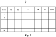
- FIG. 6 illustrates, by way of non-limiting example, another possible structure of the identifier reliability database 33.
- each line contains an identifier ID of a transmitting device 40 (or possibly a tuple of identifiers) which has already been entered in the past in at least one message previously received from a terminal 20 of the communication system 10.
- identifier ID of a transmitting device 40 (or possibly a tuple of identifiers) which has already been entered in the past in at least one message previously received from a terminal 20 of the communication system 10.
- Several pieces of information relating to said message are stored in association with said identifier (or tuple identifiers).
- the information C1, C2, ..., CK corresponds to characteristics relating to the terminal 20 determined by the access network 30 from the message received.
- Some of the information C1, C2, ..., CK may also make it possible to identify a particular geolocation server (in the case where several geolocation servers 50 are available, a reliability value may be associated with a particular geolocation server) or to characterize said geolocation server 50 (type or cost of service offered, for example).
- the identifier reliability database 33 also stores a reliability value (a score) associated with said identifier.
- a line may contain several identifiers and the associated scores. The way in which the scores are calculated will be detailed later.
- discrimination information can be determined from said message.
- the discrimination information can correspond to a particular characteristic determined for the message received, or to a combination of particular characteristics determined for the message received.
- FIG. 7 schematically represents the main steps of an example of implementation of a method 200 for updating the identifier reliability database 33 (or for creating the identifier reliability database 33 if it does not yet exist).
- the updating method 200 comprises a detection step 201, by a terminal 20 of the wireless communication system 10, for at least one transmitting device 40, of the identifier of said transmitting device 40.
- the identifier of the transmitting device 40 is detected from a message transmitted by the transmitting device 40 according to the second wireless communication protocol. It should be noted that it may be the same terminal 20 or another terminal 20 than that previously mentioned in the description of the geolocation method 100. Also, it may be the same transmitting device 40 or another transmitting device 40 than those mentioned in the description of the geolocation method 100.
- This step 201 is similar to the step 101 previously described with reference to the Figure 3 .
- the updating method 200 then comprises a step 202 of transmission, by the terminal 20, to the access network 30, of a message comprising said identifier.
- This message is transmitted by the terminal 20 according to the first wireless communication protocol.
- This step 202 is similar to the step 102 previously described with reference to the Figure 3 .
- the update method 200 comprises a step 203 of determining, without using the geolocation server 50, an approximate geographical position of the terminal 20. This step is similar to step 105 previously described with reference to the Figure 4 The various methods previously proposed in the description of step 105 for determining an approximate geographic position of the terminal 20 are also valid for this step 203.
- the updating method 200 comprises a step 204 of estimating a geographical position of the terminal 20, using the geolocation server 50, and from the received identifier.
- the reliability value associated with the identifier in the identifier reliability database 33 is not necessarily taken into account.
- the update method 200 then comprises a step 205 of verifying consistency between the approximate geographical position of the terminal 20 (determined in step 203) and the geographical position of the terminal 20 estimated (in step 204) using the geolocation server 50.
- the updating method 200 comprises a step 206 of updating the identifier reliability database 33, for said identifier, based on the result of the consistency check 205.
- steps 203, 204, 205 and 206 are implemented by the server 32 of the access network 30. It should however be noted that, in a variant, nothing would prevent all or part of these steps from being implemented by a third-party server, for example a third-party server which hosts the identifier reliability database (however, we are still in the case where the server(s) which store the identifier reliability database are distinct from the geolocation server 50).
- the consistency verification step 205 may comprise, for the received identifier, a calculation of a distance between the approximate geographical position of the terminal 20 (determined in step 203) and the geographical position associated with the identifier in the geolocation database 51 (this position generally corresponds to the position of the terminal 20 estimated in step 204, in particular when a single identifier is considered).
- P 1 the approximate geographical position of the terminal 20
- R 1 a value representative of a level of precision of the estimation of this geographical position P 1 (radius around P 1 in which the terminal is assumed to be present with a certain level of probability, for example 90%)
- P 2 the geographical position associated with the identifier in the geolocation database 51
- R 2 the value representative of the level of precision of this geographical position P 2
- dist(P 1 , P 2 ) the distance between P 1 and P 2 ;
- the approximate geographic position of the terminal 20 determined in step 203 is consistent with the geographic position associated with the identifier in the geolocation database 51.
- the contextual information representative of the geographic position of the terminal 20 determined in step 203 can be compared with the contextual information associated with the identifier of the transmitting device 40 in the geolocation database 51. This comparison can possibly be implemented using a reverse geocoding type application.
- the approximate geographical position of the terminal 20 is compared initially to one or more geographical positions determined for one or more tuples of identifiers constructed from the received identifiers.
- a first consistency check is then carried out between the approximate geographical position of the terminal 20 (determined in step 203 without the geolocation server 50) and the geographical position(s) determined with the geolocation server 50 from said tuples of identifiers. If an inconsistency is found, a second consistency check can be carried out for each identifier of the tuple considered.
- additional information can be used to weight the different identifiers making up a tuple. This additional information can correspond, for example, to power levels at which the different messages comprising the identifiers were received. by the terminal 20 from the various transmitting devices 40 detected.
- Such provisions may in particular make it possible to reduce the number of requests sent to the geolocation server 50 (a single request comprising a plurality of identifiers is sent to the geolocation server 50 initially, and individual requests relating to a single identifier are only sent if an inconsistency is observed).
- the identifier reliability database 33 only stores identifiers that are deemed reliable, it is appropriate to delete said identifier from the identifier reliability database 33.
- the identifier reliability database 33 stores only identifiers that are deemed unreliable, said identifier from the identifier reliability database 33 should be added.
- the update step 206 may include a calculation of a new reliability value for this identifier.
- the new reliability value may in particular be calculated as a function of the distance between the approximate geographical position of the terminal 20 and the geographical position associated with said identifier in the geolocation database 51.
- the new reliability value is further calculated based on a reliability value S P previously assigned to said identifier in the identifier reliability database 33.
- the identifier reliability database 33 includes, for each identifier, a date of last update of the reliability value.
- the update method 200 has been described above in a scenario where the consistency verification step 205 and the update step 206 are implemented in response to the reception of a message sent by a terminal 20. It should however be noted that the update method 200 is not necessarily implemented message by message.
- the server that implements the update method 200 may in particular be configured to collect several messages before implementing the consistency verification steps 205 and the update step 206. It may indeed be complex and costly to update a database in a “continuous” manner, and it may be more advantageous to group together checks and/or corrections to be made to the database.
- the consistency verification step 205 and the update step 206 may be delayed until a predetermined criterion is satisfied.
- This criterion may correspond in particular to the expiration of a waiting period, to the fact that a certain number of messages comprising a sender device identifier has been received, or to the fact that a certain number of sender device identifiers has been received.
- Other criteria could however be envisaged to delay, and therefore group together, the implementation of these steps for several different sender device identifiers. It is also possible to delay the update step 206 relative to the consistency verification step 205.
- each geolocation server 50 it is possible to query the different geolocation servers 50 to update the identifier reliability database.
- each reliability value being associated with a particular geolocation server 50 (each reliability value being able to be calculated based on the result of a consistency check 205 carried out for the associated geolocation server 50).
- a message comprising a list of identifiers selected according to the reliability values associated with them in the identifier reliability database 33.
- it is conceivable to communicate to the terminals a list of identifiers that are deemed reliable to encourage the terminals to send these identifiers in the messages that they send to the access network 30.
- the method 200 for updating the identifier reliability database 33 is generally not implemented for each message received from a terminal 20.
- the identifier reliability database must, however, be regularly updated because an erroneous geographical position of a transmitting device 40 in the geolocation database 51 may be corrected after a certain time. It is therefore appropriate, when an identifier is deemed unreliable in the identifier reliability database 33, to regularly implement the method 200 for updating the reliability database 33 for this identifier.
- Any type of interface can be envisaged between the server 32 of the access network 30 and the geolocation server 50 and between the server 32 and the server hosting the identifier reliability database (when the identifier reliability database is hosted by a server different from the server 32).
- FIG 8 presents as an example another particular mode of implementation of the geolocation method 100 described above with reference to the Figure 3 .
- the identifier reliability database an identifier is associated with several reliability values and each reliability value is associated with a particular geolocation server.
- each reliability value is associated with a particular value of discrimination information.
- the method 100 comprises a determination 107 of a value of the discrimination information, by the access network 30, from a message received from the terminal 20 (said message comprising at least a portion of an identifier of a transmitting device 40 detected by the terminal 20).
- the discrimination information may correspond to an approximate geographical position of the terminal 20 at the time it transmits the message (or to a geographical area in which it is estimated that the terminal 20 is located at the time it transmits the message).
- the approximate position of the terminal 20 may be estimated by the access network 30 according to different methods already described previously.
- the discrimination information may correspond to a name of a client company to which the terminal 20 belongs, a type of device corresponding to the terminal 20, etc.
- the method 100 then comprises a determination 108 of several reliability values associated with said discrimination information value in the identifier reliability database 33. It should be noted that these reliability values are not necessarily associated with identifiers corresponding to the identifier (or identifiers) detected and entered by the terminal 20.
- the method 100 then comprises a calculation 109 of an aggregated reliability value, for each of the available geolocation servers 50, from the reliability values thus determined.
- the aggregated value can be calculated according to different methods (average, median, quantile or other).
- An aggregated value can be calculated by taking into account all of the identifiers responding to the discrimination value, or only a subset of the identifiers responding to the discrimination value. It is in particular possible to take into account only the identifiers which respond to the discrimination value for all of the geolocation servers considered.
- the method 100 then comprises a selection 110 of the server 50 of geolocation to be used for the estimation 104 of the geographical position of the terminal 20 based on the calculated aggregated values (for example, the geolocation server 50 presenting the best calculated aggregated value is selected).
- the geographic position of the terminal 20 is finally determined, in step 106, from at least one of the identifiers received, using the selected geolocation server.
- an aggregated value it is possible to take into account a service cost associated with a geolocation server 50, in order to favor the least expensive geolocation servers 50.
- a service cost associated with a geolocation server 50 it is possible to take into account the number of identifiers in the reliability database 33 that meet the discrimination value.
- it is possible, when calculating an aggregated value to weight the reliability value of an identifier according to the date of the last update of said reliability value (in order to give more importance to reliability values that have been updated recently). It is also possible to weight an aggregated value calculated for a geolocation server 50 based on an average date of the last update of the reliability values of the identifiers used to calculate the aggregated value (in order to favor geolocation servers 50 for which we have more recent information).
- an aggregated value can be calculated either directly at the time when the position of the terminal 20 is sought to be determined (i.e. when the access network 30 receives one or more messages from the terminal 20 comprising one or more identifiers of transmitting devices 40), or at another time, according to particular criteria (for example, an aggregated value can be updated periodically, or after a certain number of messages have been received, etc.).
- the discrimination information is a geographical area in which the terminal 20 is located, this geographical area can be defined according to the estimated approximate position of the terminal 20, at the time when the access network 30 receives one or more messages from the terminal 20.
- This geographical area can however also be identified, according to the estimated approximate position of the terminal 20, among several geographical areas corresponding to a predetermined division of a geographical space to be covered (in this case, an aggregated value can be previously calculated for each geographical area of the division at a time which is independent of the reception of a message from the terminal 20).
- the step 106 of determining the geographical position of the terminal 20 can be implemented in different ways, and in particular as described previously with reference to the Figure 4 .
- the geolocation server 50 once the geolocation server 50 has been selected, it is possible to select one or more identifiers from among the identifiers received from the terminal 20, depending on the reliability values of said identifiers for the selected geolocation server 50.
- the geographic position of the terminal 20 can then be estimated, in step 104, from the selected identifiers, and using the selected geolocation server 50.
- the present invention achieves the set objectives.
- the invention makes it possible to make the geolocation of a terminal more reliable from one or more identifiers of neighboring transmitting devices.
- This making the geolocation of the terminal more reliable is notably implemented by a selection of the geolocation server 50 to be used and/or a selection of the identifiers to be used, thanks to the use of a database providing information on the reliability of an identifier relative to a geolocation server 50.
Landscapes
- Engineering & Computer Science (AREA)
- Physics & Mathematics (AREA)
- General Physics & Mathematics (AREA)
- Remote Sensing (AREA)
- Radar, Positioning & Navigation (AREA)
- Signal Processing (AREA)
- Computer Networks & Wireless Communication (AREA)
- Databases & Information Systems (AREA)
- Theoretical Computer Science (AREA)
- Data Mining & Analysis (AREA)
- General Engineering & Computer Science (AREA)
- Mobile Radio Communication Systems (AREA)
- Telephonic Communication Services (AREA)
- Position Fixing By Use Of Radio Waves (AREA)
Claims (16)
- Verfahren (100) zur Geolokalisierung eines Endgeräts (20) für ein Drahtloskommunikationssystem (10), wobei das Endgerät (20) geeignet ist, Nachrichten mit einem Zugangsnetzwerk (30) des Drahtloskommunikationssystems (10) gemäß einem ersten Drahtloskommunikationsprotokoll auszutauschen, wobei das Verfahren umfasst:- Erkennen (101), durch das Endgerät (20) für mindestens eine Sendevorrichtung (40), einer Kennung der Sendevorrichtung (40) auf Grundlage einer Nachricht, die von der Sendevorrichtung (40) gemäß einem zweiten Drahtloskommunikationsprotokoll gesendet wird,- Senden (102), durch das Endgerät (20) an das Zugangsnetzwerk (30) gemäß dem ersten Drahtloskommunikationsprotokoll, mindestens einer Nachricht, die eine oder mehrere erkannte Kennungen umfasst,- Bestimmen (106), durch das Zugangsnetzwerk (30), einer geografischen Position des Endgeräts (20) durch Senden einer Anfrage, die mindestens eine der empfangenen Kennungen umfasst, an einen Geolokalisierungsserver (50), der eine Geolokalisierungsdatenbank (51) speichert, die eine Liste von Kennungen von Sendevorrichtungen und die jeweiligen geografischen Positionen der Sendevorrichtungen (40) umfasst, dadurch gekennzeichnet, dass die Anfrage mithilfe einer Datenbank definiert wird, die als "Kennungszuverlässigkeitsdatenbank (33)" bezeichnet wird, welche es ermöglicht, einer beliebigen Kennung mindestens einen Wert zuzuordnen, der für die Zuverlässigkeit der Kennung für den Geolokalisierungsserver (50) repräsentativ ist, wobei die Kennungszuverlässigkeitsdatenbank (33) verwendet wird, um den Geolokalisierungsserver (50) auszuwählen, an den die Anfrage gesendet werden soll, und/oder um die Kennungen auszuwählen, die in die Anfrage eingeschlossen werden sollen, wobei die Kennungszuverlässigkeitsdatenbank (33) von einem oder mehreren Servern (32) gespeichert wird, die vom Geolokalisierungsserver (50) getrennt sind.
- Geolokalisierungsverfahren (100) nach Anspruch 1, wobei das Bestimmen (106) der geografischen Position des Endgeräts (20) umfasst:- Bestimmen (103), durch das Zugangsnetzwerk (30) mithilfe der Kennungszuverlässigkeitsdatenbank (33), für mindestens eine der empfangenen Kennungen eines Zuverlässigkeitswerts für die Kennung,- wenn die mindestens eine der empfangenen Kennungen einen zufriedenstellenden Zuverlässigkeitswert aufweist, Schätzen (104) einer geografischen Position des Endgeräts (20) auf Grundlage der Kennung mit dem Geolokalisierungsserver (50).
- Geolokalisierungsverfahren (100) nach Anspruch 2, wobei der Zuverlässigkeitswert jeder Kennung unter den empfangenen Kennungen mit einem Schwellenwert verglichen wird, um zu bestimmen, ob die Kennung zum Schätzen (104) der geografischen Position des Endgeräts (20) mithilfe des Geolokalisierungsservers (50) verwendet werden soll oder nicht.
- Verfahren (200) zum Aktualisieren einer Kennungszuverlässigkeitsdatenbank (33), wie in einem der Ansprüche 1 bis 3 definiert, wobei das Verfahren (200) umfasst:- Erkennen (201), durch ein Endgerät (20), für mindestens eine Sendevorrichtung (40), einer Kennung der Sendevorrichtung (40) auf Grundlage einer Nachricht, die von der Sendevorrichtung (40) gemäß dem zweiten Drahtloskommunikationsprotokoll gesendet wird,- Senden (202), durch das Endgerät (20) an das Zugangsnetzwerk (30) gemäß dem ersten Drahtloskommunikationsprotokoll, einer Nachricht, die die Kennung umfasst,- Schätzen (204) einer geografischen Position des Endgeräts (20) mithilfe eines Geolokalisierungsservers (50) auf Grundlage der Kennung,- Bestimmen (203), ohne den Geolokalisierungsserver (50) zu verwenden, einer ungefähren geografischen Position des Endgeräts (20),- Überprüfen (205) der Kohärenz zwischen der ungefähren geografischen Position des Endgeräts (20) und der mithilfe des Geolokalisierungsservers (50) geschätzten geografischen Position des Endgeräts (20),- Aktualisieren (206) der Kennungszuverlässigkeitsdatenbank (33) für die Kennung in Abhängigkeit vom Ergebnis der Kohärenzprüfung (205).
- Aktualisierungsverfahren (200) nach Anspruch 4, wobei das Überprüfen (205) der Kohärenz das Berechnen einer Entfernung zwischen der ungefähren geografischen Position des Endgeräts (20) und der geografischen Position, die der Kennung in der Geolokalisierungsdatenbank (51) zugeordnet ist, umfasst.
- Aktualisierungsverfahren (200) nach einem der Ansprüche 4 bis 5, wobei das Aktualisieren (206) das Berechnen eines neuen Zuverlässigkeitswerts in Abhängigkeit von einer Entfernung zwischen der ungefähren geografischen Position des Endgeräts (20) und der geografischen Position, die der Kennung in der Geolokalisierungsdatenbank (51) zugeordnet ist, umfasst.
- Aktualisierungsverfahren (200) nach Anspruch 6, wobei der neue Zuverlässigkeitswert weiter in Abhängigkeit von einem Zuverlässigkeitswert berechnet wird, der der Kennung zuvor in der Kennungszuverlässigkeitsdatenbank (33) zugewiesen war.
- Server (32) für ein Zugangsnetzwerk (30) eines Drahtloskommunikationssystems (10), wobei das System (10) mindestens ein Endgerät (20) umfasst, das geeignet ist, Nachrichten mit dem Zugangsnetzwerk (30) gemäß einem ersten Drahtloskommunikationsprotokoll auszutauschen und eine Nachricht, die von einer Sendevorrichtung (40) gemäß einem zweiten Drahtloskommunikationsprotokoll gesendet wird, zu empfangen, wobei der Server (32) dadurch gekennzeichnet ist, dass er dafür konfiguriert ist:- vom Endgerät (20) mindestens eine Nachricht zu empfangen, die mindestens eine Kennung einer Sendevorrichtung (40), die von dem Endgerät (20) erkannt wurde, umfasst,- eine geografische Position des Endgeräts (20) zu bestimmen durch Senden einer Anfrage, die mindestens eine der empfangenen Kennungen umfasst, an einen Geolokalisierungsserver (50), der eine Geolokalisierungsdatenbank (51) speichert, die eine Liste von Kennungen von Sendevorrichtungen und die jeweiligen geografischen Positionen der Sendevorrichtungen (40) umfasst, dadurch gekennzeichnet, dass die Anfrage mithilfe einer Datenbank definiert wird, die als "Kennungszuverlässigkeitsdatenbank (33)" bezeichnet wird, welche es ermöglicht, einer beliebigen Kennung mindestens einen Wert zuzuordnen, der für die Zuverlässigkeit der Kennung für den Geolokalisierungsserver (50) repräsentativ ist, wobei die Kennungszuverlässigkeitsdatenbank (33) verwendet wird, um den Geolokalisierungsserver (50) auszuwählen, an den die Anfrage gesendet werden soll, und/oder um die Kennungen auszuwählen, die in die Anfrage eingeschlossen werden sollen, wobei die Kennungszuverlässigkeitsdatenbank (33) von einem oder mehreren Servern (32) gespeichert wird, die vom Geolokalisierungsserver (50) getrennt sind.
- Server (32) nach Anspruch 8, der dafür konfiguriert ist:- für mindestens eine der empfangenen Kennungen mithilfe der Kennungszuverlässigkeitsdatenbank (33) einen Zuverlässigkeitswert zu bestimmen,- wenn mindestens eine der empfangenen Kennungen einen zufriedenstellenden Zuverlässigkeitswert aufweist, eine geografische Position des Endgeräts (20) auf Grundlage der Kennung mit dem Geolokalisierungsserver (50) zu schätzen.
- Server (32) nach Anspruch 9, wobei der Server (32) weiter dafür konfiguriert ist, wenn keine der empfangenen Kennungen einen zufriedenstellenden Zuverlässigkeitswert aufweist, eine ungefähre geografische Position des Endgeräts (20) ohne Hilfe des Geolokalisierungsservers (50) zu schätzen.
- Server (32) nach Anspruch 10, wobei der Server (32) weiter dafür konfiguriert ist, für mindestens eine der empfangenen Kennungen die ungefähre geografische Position des Endgeräts (20) auf Grundlage einer ungefähren geografischen Position der Sendevorrichtung (40), die die Kennung trägt, zu schätzen, wobei die ungefähre geografische Position der Sendevorrichtung (40) zuvor vom Server (32) ohne Hilfe des Geolokalisierungservers (50) bestimmt und in der Kennungszuverlässigkeitsdatenbank (33) gespeichert wurde.
- Server (32) nach Anspruch 9, wobei die mindestens eine der empfangenen Kennungen in der Kennungszuverlässigkeitsdatenbank (33) mehreren Zuverlässigkeitswerten zugeordnet ist, die jeweils einem unterschiedlichen Wert einer Unterscheidungsinformation zugeordnet sind, welche es ermöglicht, einen Geolokalisierungsserver (50) zu identifizieren, und der Server (32) weiter dafür konfiguriert ist, in Abhängigkeit von den unterschiedlichen Zuverlässigkeitswerten, die der Kennung zugeordnet sind, den Geolokalisierungsserver (50) auszuwählen, der verwendet werden soll, um die geografische Position des Endgeräts (20) zu schätzen.
- Server (32) nach Anspruch 8, wobei eine beliebige Kennung in der Kennungszuverlässigkeitsdatenbank (33) mehreren Zuverlässigkeitswerten zugeordnet sein kann, die jeweils einem unterschiedlichen Wert einer Unterscheidungsinformation zugeordnet sind, und der Server (32) dafür konfiguriert ist:- einen Wert der Unterscheidungsinformation auf Grundlage der mindestens einen Nachricht, die vom Endgerät (20) empfangen wurde, zu bestimmen,- mehrere Zuverlässigkeitswerte zu bestimmen, die dem Wert der Unterscheidungsinformation in der Kennungszuverlässigkeitsdatenbank (33) zugeordnet sind,- einen aggregierten Zuverlässigkeitswert für jeden einer Vielzahl von Geolokalisierungsservern (50) auf Grundlage der so bestimmten Zuverlässigkeitswerte zu berechnen,- den Geolokalisierungsserver (50), der zum Schätzen (104) der geografischen Position des Endgeräts (20) verwendet werden soll, in Abhängigkeit von den berechneten aggregierten Werten auszuwählen.
- Server (32) nach Anspruch 8, wobei der Server (32) weiter dafür konfiguriert ist:- eine ungefähre geografische Position des Endgeräts (20) zu bestimmen, ohne den Geolokalisierungsserver (50) zu verwenden,- eine Kohärenz zwischen der ungefähren geografischen Position des Endgeräts (20) und der mit Hilfe des Geolokalisierungsservers (50) geschätzten geografischen Position des Endgeräts (20) zu überprüfen,- die Kennungszuverlässigkeitsdatenbank (33) für mindestens eine der empfangenen Kennungen in Abhängigkeit vom Ergebnis der Kohärenzprüfung zu aktualisieren.
- Server (32) nach Anspruch 14, wobei der Server (32) weiter dafür konfiguriert ist, für mindestens eine der empfangenen Kennungen einen neuen Zuverlässigkeitswert in Abhängigkeit von einer Entfernung zwischen der ungefähren geografischen Position des Endgeräts (20) und der geografischen Position, die der Kennung in der Geolokalisierungsdatenbank (51) zugeordnet ist, zu berechnen.
- Zugangsnetzwerk (30) mit einem Server (32) nach einem der Ansprüche 8 bis 15.
Applications Claiming Priority (2)
| Application Number | Priority Date | Filing Date | Title |
|---|---|---|---|
| FR2106964A FR3124680B1 (fr) | 2021-06-29 | 2021-06-29 | Fiabilisation de la géolocalisation d’un terminal à partir d’un ou plusieurs identifiants de dispositifs émetteurs voisins |
| PCT/EP2022/066804 WO2023274778A1 (fr) | 2021-06-29 | 2022-06-21 | Fiabilisation de la géolocalisation d'un terminal à partir d'un ou plusieurs identifiants de dispositifs émetteurs voisins |
Publications (3)
| Publication Number | Publication Date |
|---|---|
| EP4364483A1 EP4364483A1 (de) | 2024-05-08 |
| EP4364483C0 EP4364483C0 (de) | 2025-05-21 |
| EP4364483B1 true EP4364483B1 (de) | 2025-05-21 |
Family
ID=78332840
Family Applications (1)
| Application Number | Title | Priority Date | Filing Date |
|---|---|---|---|
| EP22737812.2A Active EP4364483B1 (de) | 2021-06-29 | 2022-06-21 | Erhöhung der zuverlässigkeit der ortung eines terminals basierend auf einem oder mehreren kennungen von nah gelegenen sendegeräten |
Country Status (9)
| Country | Link |
|---|---|
| US (1) | US20250024407A1 (de) |
| EP (1) | EP4364483B1 (de) |
| JP (1) | JP2024528470A (de) |
| KR (1) | KR20240026949A (de) |
| AU (1) | AU2022304088A1 (de) |
| ES (1) | ES3034408T3 (de) |
| FR (1) | FR3124680B1 (de) |
| WO (1) | WO2023274778A1 (de) |
| ZA (1) | ZA202311768B (de) |
Family Cites Families (10)
| Publication number | Priority date | Publication date | Assignee | Title |
|---|---|---|---|---|
| US6985745B2 (en) * | 2002-11-25 | 2006-01-10 | Telefonaktiebolaget L M Ericsson (Publ) | Method and radio signature position determining entity (RS-PDE) for maintaining location database reliability |
| US7224983B2 (en) * | 2003-01-08 | 2007-05-29 | Lucent Technologies Inc. | Method and apparatus for geolocation estimates in wireless networks |
| US9063209B2 (en) * | 2009-11-05 | 2015-06-23 | Samsung Sds Co., Ltd. | Location tracking system and method of wireless device using wireless LAN access point |
| US8447326B2 (en) * | 2010-04-07 | 2013-05-21 | Apple Inc. | Selective location determination |
| US20130143585A1 (en) * | 2011-12-02 | 2013-06-06 | Peter Kenington | Method and apparatus for geolocating a wireless communication unit |
| KR20130080987A (ko) * | 2012-01-06 | 2013-07-16 | 한국전자통신연구원 | 지오-로케이션 데이터베이스에 기반한 무선 인지 메쉬 네트워크를 위한 장치 및 이를 이용한 방법 |
| US9392567B2 (en) * | 2012-11-30 | 2016-07-12 | Qualcomm Incorporated | Distributed system architecture to provide wireless transmitter positioning |
| FR3074305B1 (fr) * | 2017-11-30 | 2021-02-12 | Sigfox | Procede et systeme de geolocalisation d’un terminal occupant des positions geographiques particulieres |
| FR3084555B1 (fr) * | 2018-07-24 | 2022-12-02 | Sigfox | Procede et systeme de geolocalisation d’un terminal a portee d’un dispositif emetteur d’interet |
| FR3096789B1 (fr) * | 2019-05-28 | 2021-05-14 | Sigfox | Procédé et système de géolocalisation d’un objet à l’aide d’une station de base mobile |
-
2021
- 2021-06-29 FR FR2106964A patent/FR3124680B1/fr active Active
-
2022
- 2022-06-21 AU AU2022304088A patent/AU2022304088A1/en active Pending
- 2022-06-21 EP EP22737812.2A patent/EP4364483B1/de active Active
- 2022-06-21 US US18/575,065 patent/US20250024407A1/en active Pending
- 2022-06-21 KR KR1020237044857A patent/KR20240026949A/ko active Pending
- 2022-06-21 ES ES22737812T patent/ES3034408T3/es active Active
- 2022-06-21 WO PCT/EP2022/066804 patent/WO2023274778A1/fr not_active Ceased
- 2022-06-21 JP JP2023579253A patent/JP2024528470A/ja active Pending
-
2023
- 2023-12-21 ZA ZA2023/11768A patent/ZA202311768B/en unknown
Also Published As
| Publication number | Publication date |
|---|---|
| FR3124680B1 (fr) | 2023-09-22 |
| EP4364483C0 (de) | 2025-05-21 |
| JP2024528470A (ja) | 2024-07-30 |
| FR3124680A1 (fr) | 2022-12-30 |
| EP4364483A1 (de) | 2024-05-08 |
| ES3034408T3 (en) | 2025-08-18 |
| KR20240026949A (ko) | 2024-02-29 |
| ZA202311768B (en) | 2025-06-25 |
| WO2023274778A1 (fr) | 2023-01-05 |
| AU2022304088A1 (en) | 2024-01-18 |
| US20250024407A1 (en) | 2025-01-16 |
Similar Documents
| Publication | Publication Date | Title |
|---|---|---|
| EP3596485B1 (de) | Verfahren und system zur geolokalisierung eines endgeräts eines drahtloskommunikationssystems | |
| EP2120411A1 (de) | Adaptation des Präsenzstatus von Instant-Messaging | |
| EP3395045B1 (de) | Verfahren zur bestimmung einer temporären referenz und/oder mindestens einer räumlichen referenz in einem kommunikationssystem | |
| EP4364483B1 (de) | Erhöhung der zuverlässigkeit der ortung eines terminals basierend auf einem oder mehreren kennungen von nah gelegenen sendegeräten | |
| EP3827624B1 (de) | Verfahren und system zur geolokalisierung eines endgeräts im bereich einer bestimmten sendevorrichtung | |
| EP3769105B1 (de) | Verfahren und system zur geolokation von gruppenentwicklungsendgeräten | |
| EP3038417B1 (de) | Überprüfungsverfahren einer lokalisierungsinformation eines endgeräts, das mit einem mobilfunknetz verbunden ist | |
| US9726500B2 (en) | Method and system for generating synthetic location information | |
| WO2005029118A1 (fr) | Procede pour detecter la presence ou l’absence d’un terminal mobile sur un chemin | |
| WO2022223388A1 (fr) | Procédé de mise à jour d'une base de données d'un serveur de géolocalisation | |
| FR3068140B1 (fr) | Procede de mise a jour d'un jeu de parametres orbitaux stocke dans une balise de geolocalisation, produit programme d'ordinateur, dispositif de mise a jour et balise correspondants. | |
| EP4342207A1 (de) | Optimierung der geolokalisierung eines endgeräts von einer oder mehreren identifikatoren benachbarter sendevorrichtungen | |
| EP4007335A1 (de) | Verfahren zur auswahl eines kanals in einem drahtlosen accesspoint-gerät eines kommunikationsnetzes und entsprechendes drahtloses accesspoint-gerät | |
| WO2021069636A1 (fr) | Procédé de géolocalisation d'une station de base d'un système de communication sans fil | |
| EP4405702A1 (de) | Zusammenarbeit zwischen zwei verfahren zur geolokalisierung eines endgeräts eines drahtlosen kommunikationssystems | |
| EP4226173A1 (de) | Verfahren zur geolokalisierung einer funkbake eines drahtlosen kommunikationssystems | |
| EP3899747A1 (de) | Verfahren und struktur zur störmeldung | |
| FR2934747A1 (fr) | Systeme de localisation embarque dans un terminal mobile pour maintenir a jour la meilleure position geographique disponible dudit terminal | |
| FR2822629A1 (fr) | Systeme de supervision de donnees de localisation de dispositifs geolocalisables | |
| FR3015088A1 (fr) | Procede de mesure d'une position d'un terminal, dispositif et programme d'ordinateur correspondant. |
Legal Events
| Date | Code | Title | Description |
|---|---|---|---|
| STAA | Information on the status of an ep patent application or granted ep patent |
Free format text: STATUS: UNKNOWN |
|
| STAA | Information on the status of an ep patent application or granted ep patent |
Free format text: STATUS: THE INTERNATIONAL PUBLICATION HAS BEEN MADE |
|
| PUAI | Public reference made under article 153(3) epc to a published international application that has entered the european phase |
Free format text: ORIGINAL CODE: 0009012 |
|
| STAA | Information on the status of an ep patent application or granted ep patent |
Free format text: STATUS: REQUEST FOR EXAMINATION WAS MADE |
|
| 17P | Request for examination filed |
Effective date: 20240110 |
|
| AK | Designated contracting states |
Kind code of ref document: A1 Designated state(s): AL AT BE BG CH CY CZ DE DK EE ES FI FR GB GR HR HU IE IS IT LI LT LU LV MC MK MT NL NO PL PT RO RS SE SI SK SM TR |
|
| DAV | Request for validation of the european patent (deleted) | ||
| DAX | Request for extension of the european patent (deleted) | ||
| GRAP | Despatch of communication of intention to grant a patent |
Free format text: ORIGINAL CODE: EPIDOSNIGR1 |
|
| STAA | Information on the status of an ep patent application or granted ep patent |
Free format text: STATUS: GRANT OF PATENT IS INTENDED |
|
| INTG | Intention to grant announced |
Effective date: 20250303 |
|
| GRAS | Grant fee paid |
Free format text: ORIGINAL CODE: EPIDOSNIGR3 |
|
| GRAA | (expected) grant |
Free format text: ORIGINAL CODE: 0009210 |
|
| STAA | Information on the status of an ep patent application or granted ep patent |
Free format text: STATUS: THE PATENT HAS BEEN GRANTED |
|
| AK | Designated contracting states |
Kind code of ref document: B1 Designated state(s): AL AT BE BG CH CY CZ DE DK EE ES FI FR GB GR HR HU IE IS IT LI LT LU LV MC MK MT NL NO PL PT RO RS SE SI SK SM TR |
|
| RAP3 | Party data changed (applicant data changed or rights of an application transferred) |
Owner name: UNABIZ |
|
| REG | Reference to a national code |
Ref country code: GB Ref legal event code: FG4D Free format text: NOT ENGLISH |
|
| REG | Reference to a national code |
Ref country code: CH Ref legal event code: EP |
|
| REG | Reference to a national code |
Ref country code: DE Ref legal event code: R096 Ref document number: 602022014981 Country of ref document: DE |
|
| REG | Reference to a national code |
Ref country code: IE Ref legal event code: FG4D Free format text: LANGUAGE OF EP DOCUMENT: FRENCH |
|
| U01 | Request for unitary effect filed |
Effective date: 20250522 |
|
| U07 | Unitary effect registered |
Designated state(s): AT BE BG DE DK EE FI FR IT LT LU LV MT NL PT RO SE SI Effective date: 20250603 |
|
| U20 | Renewal fee for the european patent with unitary effect paid |
Year of fee payment: 4 Effective date: 20250619 |
|
| REG | Reference to a national code |
Ref country code: ES Ref legal event code: FG2A Ref document number: 3034408 Country of ref document: ES Kind code of ref document: T3 Effective date: 20250818 |
|
| PGFP | Annual fee paid to national office [announced via postgrant information from national office to epo] |
Ref country code: ES Payment date: 20250707 Year of fee payment: 4 |
|
| PG25 | Lapsed in a contracting state [announced via postgrant information from national office to epo] |
Ref country code: NO Free format text: LAPSE BECAUSE OF FAILURE TO SUBMIT A TRANSLATION OF THE DESCRIPTION OR TO PAY THE FEE WITHIN THE PRESCRIBED TIME-LIMIT Effective date: 20250821 Ref country code: GR Free format text: LAPSE BECAUSE OF FAILURE TO SUBMIT A TRANSLATION OF THE DESCRIPTION OR TO PAY THE FEE WITHIN THE PRESCRIBED TIME-LIMIT Effective date: 20250822 |
|
| PG25 | Lapsed in a contracting state [announced via postgrant information from national office to epo] |
Ref country code: PL Free format text: LAPSE BECAUSE OF FAILURE TO SUBMIT A TRANSLATION OF THE DESCRIPTION OR TO PAY THE FEE WITHIN THE PRESCRIBED TIME-LIMIT Effective date: 20250521 |
|
| PG25 | Lapsed in a contracting state [announced via postgrant information from national office to epo] |
Ref country code: HR Free format text: LAPSE BECAUSE OF FAILURE TO SUBMIT A TRANSLATION OF THE DESCRIPTION OR TO PAY THE FEE WITHIN THE PRESCRIBED TIME-LIMIT Effective date: 20250521 |
|
| PG25 | Lapsed in a contracting state [announced via postgrant information from national office to epo] |
Ref country code: RS Free format text: LAPSE BECAUSE OF FAILURE TO SUBMIT A TRANSLATION OF THE DESCRIPTION OR TO PAY THE FEE WITHIN THE PRESCRIBED TIME-LIMIT Effective date: 20250821 |
|
| PG25 | Lapsed in a contracting state [announced via postgrant information from national office to epo] |
Ref country code: IS Free format text: LAPSE BECAUSE OF FAILURE TO SUBMIT A TRANSLATION OF THE DESCRIPTION OR TO PAY THE FEE WITHIN THE PRESCRIBED TIME-LIMIT Effective date: 20250921 |
|
| U1N | Appointed representative for the unitary patent procedure changed after the registration of the unitary effect |
Representative=s name: SANTARELLI; FR |
|
| PG25 | Lapsed in a contracting state [announced via postgrant information from national office to epo] |
Ref country code: SM Free format text: LAPSE BECAUSE OF FAILURE TO SUBMIT A TRANSLATION OF THE DESCRIPTION OR TO PAY THE FEE WITHIN THE PRESCRIBED TIME-LIMIT Effective date: 20250521 |
|
| PG25 | Lapsed in a contracting state [announced via postgrant information from national office to epo] |
Ref country code: CZ Free format text: LAPSE BECAUSE OF FAILURE TO SUBMIT A TRANSLATION OF THE DESCRIPTION OR TO PAY THE FEE WITHIN THE PRESCRIBED TIME-LIMIT Effective date: 20250521 |
|
| PG25 | Lapsed in a contracting state [announced via postgrant information from national office to epo] |
Ref country code: SK Free format text: LAPSE BECAUSE OF FAILURE TO SUBMIT A TRANSLATION OF THE DESCRIPTION OR TO PAY THE FEE WITHIN THE PRESCRIBED TIME-LIMIT Effective date: 20250521 |
|
| REG | Reference to a national code |
Ref country code: CH Ref legal event code: H13 Free format text: ST27 STATUS EVENT CODE: U-0-0-H10-H13 (AS PROVIDED BY THE NATIONAL OFFICE) Effective date: 20260127 |