EP4134837A2 - Methode und gerät zur entdeckung einer neu hinzugefügten strasse - Google Patents
Methode und gerät zur entdeckung einer neu hinzugefügten strasse Download PDFInfo
- Publication number
- EP4134837A2 EP4134837A2 EP22215544.2A EP22215544A EP4134837A2 EP 4134837 A2 EP4134837 A2 EP 4134837A2 EP 22215544 A EP22215544 A EP 22215544A EP 4134837 A2 EP4134837 A2 EP 4134837A2
- Authority
- EP
- European Patent Office
- Prior art keywords
- trajectory
- grid
- determining
- portrait data
- target area
- Prior art date
- Legal status (The legal status is an assumption and is not a legal conclusion. Google has not performed a legal analysis and makes no representation as to the accuracy of the status listed.)
- Withdrawn
Links
Images


Classifications
-
- G—PHYSICS
- G06—COMPUTING OR CALCULATING; COUNTING
- G06F—ELECTRIC DIGITAL DATA PROCESSING
- G06F16/00—Information retrieval; Database structures therefor; File system structures therefor
- G06F16/20—Information retrieval; Database structures therefor; File system structures therefor of structured data, e.g. relational data
- G06F16/29—Geographical information databases
-
- G—PHYSICS
- G01—MEASURING; TESTING
- G01C—MEASURING DISTANCES, LEVELS OR BEARINGS; SURVEYING; NAVIGATION; GYROSCOPIC INSTRUMENTS; PHOTOGRAMMETRY OR VIDEOGRAMMETRY
- G01C21/00—Navigation; Navigational instruments not provided for in groups G01C1/00 - G01C19/00
- G01C21/38—Electronic maps specially adapted for navigation; Updating thereof
- G01C21/3804—Creation or updating of map data
- G01C21/3807—Creation or updating of map data characterised by the type of data
- G01C21/3815—Road data
-
- G—PHYSICS
- G06—COMPUTING OR CALCULATING; COUNTING
- G06T—IMAGE DATA PROCESSING OR GENERATION, IN GENERAL
- G06T11/00—Two-dimensional [2D] image generation
- G06T11/20—Drawing from basic elements
- G06T11/26—Drawing of charts or graphs
-
- G—PHYSICS
- G01—MEASURING; TESTING
- G01C—MEASURING DISTANCES, LEVELS OR BEARINGS; SURVEYING; NAVIGATION; GYROSCOPIC INSTRUMENTS; PHOTOGRAMMETRY OR VIDEOGRAMMETRY
- G01C21/00—Navigation; Navigational instruments not provided for in groups G01C1/00 - G01C19/00
- G01C21/38—Electronic maps specially adapted for navigation; Updating thereof
- G01C21/3804—Creation or updating of map data
- G01C21/3833—Creation or updating of map data characterised by the source of data
- G01C21/3837—Data obtained from a single source
-
- G—PHYSICS
- G06—COMPUTING OR CALCULATING; COUNTING
- G06F—ELECTRIC DIGITAL DATA PROCESSING
- G06F16/00—Information retrieval; Database structures therefor; File system structures therefor
- G06F16/20—Information retrieval; Database structures therefor; File system structures therefor of structured data, e.g. relational data
- G06F16/23—Updating
-
- G—PHYSICS
- G06—COMPUTING OR CALCULATING; COUNTING
- G06T—IMAGE DATA PROCESSING OR GENERATION, IN GENERAL
- G06T5/00—Image enhancement or restoration
- G06T5/50—Image enhancement or restoration using two or more images, e.g. averaging or subtraction
-
- G—PHYSICS
- G06—COMPUTING OR CALCULATING; COUNTING
- G06T—IMAGE DATA PROCESSING OR GENERATION, IN GENERAL
- G06T5/00—Image enhancement or restoration
- G06T5/70—Denoising; Smoothing
-
- G—PHYSICS
- G06—COMPUTING OR CALCULATING; COUNTING
- G06T—IMAGE DATA PROCESSING OR GENERATION, IN GENERAL
- G06T9/00—Image coding
- G06T9/005—Statistical coding, e.g. Huffman, run length coding
-
- G—PHYSICS
- G06—COMPUTING OR CALCULATING; COUNTING
- G06V—IMAGE OR VIDEO RECOGNITION OR UNDERSTANDING
- G06V20/00—Scenes; Scene-specific elements
- G06V20/10—Terrestrial scenes
- G06V20/182—Network patterns, e.g. roads or rivers
-
- G—PHYSICS
- G06—COMPUTING OR CALCULATING; COUNTING
- G06T—IMAGE DATA PROCESSING OR GENERATION, IN GENERAL
- G06T2207/00—Indexing scheme for image analysis or image enhancement
- G06T2207/10—Image acquisition modality
- G06T2207/10032—Satellite or aerial image; Remote sensing
-
- G—PHYSICS
- G06—COMPUTING OR CALCULATING; COUNTING
- G06T—IMAGE DATA PROCESSING OR GENERATION, IN GENERAL
- G06T2207/00—Indexing scheme for image analysis or image enhancement
- G06T2207/20—Special algorithmic details
- G06T2207/20212—Image combination
- G06T2207/20224—Image subtraction
Definitions
- the present invention relates to the technical field of artificial intelligence, in particular to the technical fields of automatic driving, cloud computing, intelligent transportation, and natural language processing, and in particular to a method and an apparatus for discovering a newly added road.
- the method for discovering a newly added road is mainly to compare remote sensing images collected by sensors at different time points for the same area, for example, image overlay detection processing, image data difference or ratio processing, etc., determine differences between the remote sensing images of different times, and determine newly added roads in the area according to the differences, which takes a long time and is inefficient.
- the present invention provides a method and an apparatus for discovering a newly added road.
- a method for discovering a newly added road including: determining trajectory data in a target area within a preset time period, in which the trajectory data includes a plurality of trajectories and attribute information of each trajectory point in respective trajectories; determining trajectory features of a plurality of grids in the target area, according to the plurality of trajectories, the attribute information of each trajectory point in respective trajectories, and position features of the plurality of grids; generating current grid portrait data of the target area, according to the position features and trajectory features of the plurality of grids; and determining newly added road information of the target area, according to the current grid portrait data and historical grid portrait data of the target area.
- determining the trajectory features of the plurality of grids in the target area according to the plurality of trajectories, the attribute information of each trajectory point in respective trajectories, and position features of the plurality of grids includes: determining for each trajectory, a grid to which each trajectory point in the trajectory belongs according to the attribute information of each trajectory point in the trajectory and the position features of the plurality of grids; and determining for each grid, the trajectory features of the grid according to the attribute information of the trajectory points belonging to the grid.
- the attribute information includes position information, determining for each trajectory, the grid to which each trajectory point in the trajectory belongs according to the attribute information of each trajectory point in the trajectory and the position features of the plurality of grids includes: determining for each trajectory point in each trajectory, a grid of which corresponding position feature matches the position information according to the position information of the trajectory point and the position features of the plurality of grids; and determining the matched grid as the grid to which the trajectory point belongs.
- the attribute information further includes a trajectory identifier
- grid features include a trajectory flux
- determining for each grid, the trajectory features of the grid according to the attribute information of the trajectory points belonging to the grid includes: determining for each grid, the number of trajectories passing through the grid according to the trajectory identifiers of the trajectory points belonging to the grid; and determining the number of trajectories as the trajectory flux of the grid.
- the method further includes: performing for each trajectory, linear interpolation on the trajectory points in the trajectory.
- the trajectory features include a trajectory flux, determining the newly added road information of the target area according to the current grid portrait data and the historical grid portrait data of the target area, includes: determining current binary portrait data according to the grid flux of each grid in the current grid portrait data and a preset flux threshold, in which a first value in the current binary portrait data represents that the grid flux of the corresponding grid is greater than or equal to the preset flux threshold; determining historical binary portrait data according to the historical grid portrait data; determining at least one target grid according to the current binary portrait data and the historical binary portrait data, in which a value of the target grid in the current binary portrait data is different from the value of the target grid in the historical binary portrait data; and determining the newly added road information of the target area according to the at least one target grid.
- the grid features further include a direction feature and a speed feature, which are determined according to direction information and speed information of the trajectory points belonging to the grid, determining the newly added road information of the target area according to the at least one target grid, includes: determining at least one candidate newly added road information of the target area according to the at least one target grid; and selecting the newly added road information of the target area from the at least one candidate newly added road information, according to the direction feature and speed feature of the at least one target grid.
- the method further includes: determining remote sensing image data of the target area; determining whether a road corresponding to the newly added road information really exists, according to the remote sensing image data; and updating a road map of the target area according to the newly added road information, when it is determined that the road really exists.
- an apparatus for discovering a newly added road including: a first determining module, configured to determine trajectory data in a target area within a preset time period, in which the trajectory data includes a plurality of trajectories and attribute information of each trajectory point in respective trajectories; a second determining module, configured to determine trajectory features of a plurality of grids in the target area, according to the plurality of trajectories, the attribute information of each trajectory point in respective trajectories, and position features of the plurality of grids; a generating module, configured to generate current grid portrait data of the target area, according to the position features and trajectory features of the plurality of grids; and a third determining module, configured to determine newly added road information of the target area, according to the current grid portrait data and historical grid portrait data of the target area.
- the second determining module includes a first determining unit and a second determining unit.
- the first determining unit is configured to determine for each trajectory, a grid to which each trajectory point in the trajectory belongs according to the attribute information of each trajectory point in the trajectory and the position features of the plurality of grids.
- the second determining unit is configured to determine for each grid, the trajectory features of the grid according to the attribute information of the trajectory points belonging to the grid.
- the attribute information includes position information.
- the first determining unit is further configured to: determine for each trajectory point in each trajectory, a grid of which corresponding position feature matches the position information according to the position information of the trajectory point and the position features of the plurality of grids; and determine the matched grid as the grid to which the trajectory point belongs.
- the attribute information further includes a trajectory identifier
- the grid features include a trajectory flux.
- the second determining unit is further configured to: determine for each grid, the number of trajectories passing through the grid according to the trajectory identifiers of the trajectory points belonging to the grid; and determine the number of trajectories as the trajectory flux of the grid.
- the second determining module further includes an interpolation processing unit, configured to perform for each trajectory, linear interpolation on the trajectory points in the trajectory.
- the trajectory features include a trajectory flux.
- the third determining module is further configured to: determine current binary portrait data according to the grid flux of each grid in the current grid portrait data and a preset flux threshold, in which a first value in the current binary portrait data represents that the grid flux of the corresponding grid is greater than or equal to the preset flux threshold; determine historical binary portrait data according to the historical grid portrait data; determine at least one target grid according to the current binary portrait data and the historical binary portrait data, in which a value of the target grid in the current binary portrait data is different from the value of the target grid in the historical binary portrait data; and determine the newly added road information of the target area according to the at least one target grid.
- a computer readable storage medium storing computer instructions.
- the computer instructions are configured to enable the computer to implement the method for discovering a newly added road of the aspect of the present invention.
- the method for discovering a newly added road is mainly to compare remote sensing images collected by sensors at different time points for the same area, for example, image overlay detection processing, image data difference or ratio processing, etc., determine differences between the remote sensing images of different times, and determine newly added roads in the area according to the differences, which takes a long time and is inefficient.
- the present invention provides a method and an apparatus for discovering a newly added road, and electronic device.
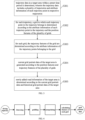
- FIG. 1 is a schematic diagram according to a first embodiment of the present invention. It should be noted that the method for discovering a newly added road in the embodiment of the present invention can be applied to an apparatus for discovering a newly added road, and the apparatus can be configured in an electronic device to enable the electronic device to perform the function of discovering a newly added road.
- the electronic device may be any device with computing capability.
- the device with computing capability may be, for example, a personal computer (PC), a mobile terminal, a server, etc.
- the mobile terminal may be, for example, a hardware device having various operating systems, touch screens and/or displays, such as an onboard device, a mobile phone, a tablet computer, a personal digital assistant, a wearable device, etc.
- the method for discovering a newly added road may include the following steps: In S 101, trajectory data in a target area within a preset time period is determined, in which the trajectory data includes a plurality of trajectories and attribute information of each trajectory point in respective trajectories.
- the preset time period may be, for example, 1 day, 2 days, 15 days, 1 month, etc., and may be set according to actual needs.
- the trajectory data in the target area within the preset time period refers to the trajectory data of any vehicle driving in the target area within the preset time period.
- the trajectory data can be collected by the controller on the vehicle during the driving of the vehicle.
- the trajectory in the trajectory data may be obtained by dividing the moving trajectory of any vehicle in a long period of time according to the speed and the like.
- the attribute information of each trajectory point in the trajectory may include at least one of: position information, trajectory identifier, direction information, and speed information.
- the trajectory data may be filtered to improve the accuracy of the trajectory data, for example, the trajectory data of the subway, the trajectory data of the train and the like are filtered out.
- the trajectory data in which the speed is abnormal can also be filtered out.
- trajectory features of a plurality of grids in the target area are determined according to the multiple trajectories, the attribute information of each trajectory point in respective trajectories, and the position features of the plurality of grids.
- the target area may be divided according to a specified grid size to obtain a plurality of grids.
- the size information of the plurality of grids is the same, for example, both are 2m long and 2m wide.
- the position feature of the grid i.e., position information of the grid, may be represented by a upper left corner coordinate, lower left corner coordinate, upper right corner coordinate, lower right corner coordinate, or center point coordinate of the grid.
- the attribute information of the trajectory points may include the position information of the trajectory points. According to the position information of the trajectory points and the position feature of the grid, correspondence relationships between the trajectory points and the grid may be determined, and then the trajectory features of the grid are determined according to the trajectory points corresponding to the grid.
- current grid portrait data of the target area is generated according to the position features and trajectory features of the plurality of grids.
- the current grid portrait data of the target area includes the position features and trajectory features of the plurality of grids.
- the current grid portrait data may be stored in a matrix storage mode, for example, in the matrix storage mode of Ndarray.
- the current grid portrait data may be compressed according to the zlib compression mode, and transcoding processed by using a base64 transcoding mode, and the result of transcoding processing is stored.
- the zlib compression is to perform Huffman encoding on the current grid portrait data to obtain a binary encoding result.
- the base64 transcoding is to perform string conversion processing on the binary encoding result to prevent problems when reading the binary encoding result.
- the current grid portrait data and the historical grid portrait data may be processed with at least one of Gaussian smoothing, high-pass filtering, and median filtering and so on, to filter out interference information such as noise in the data.
- S 104 newly added road information of the target area is determined according to the current grid portrait data and historical grid portrait data of the target area.
- the current grid portrait data is generated according to the trajectory data in the target area within a preset time period
- the historical grid portrait data may be generated according to the trajectory data in the target area within the historical time period.
- the preset time period and the historical time period may be separated by a time period, or may be adjacent. Whether the preset time period and the historical time period are adjacent or separated by a time period can be set according to actual needs. For example, assuming that the current time point is May 30, the preset time period can be the time period from May 20 to May 30, the historical time period can be the time period from May 1 to May 10, or the time period from May 10 to May 20.
- the process of performing S 104 by the apparatus for discovering a newly added road may include, for example: determining current binary portrait data according to the grid flux of each grid in the current grid portrait data and a preset flux threshold, in which a first value in the current binary portrait data represents that the grid flux of the corresponding grid is greater than or equal to the preset flux threshold; determining historical binary portrait data according to the historical grid portrait data; determining at least one target grid according to the current binary portrait data and the historical binary portrait data, in which a value of the target grid in the current binary portrait data is different from the value of the target grid in the historical binary portrait data; determining the newly added road information of the target area according to the at least one target grid.
- the process of determining the current binary portrait data may be, for example, for each grid, when the grid flux of the grid in the current grid portrait data is greater than or equal to the preset flux threshold, determining the value of the grid in the current binary portrait data to be the first value; when the grid flux of the grid in the current grid portrait data is less than the preset flux threshold, determining the value of the grid in the current binary portrait data to be the second value.
- the first value may be 1, and the second value may be 0.
- the process of determining the historical binary portrait data may be, for example, for each grid, when the grid flux of the grid in the historical grid portrait data is greater than or equal to a preset flux threshold, determining the value of the grid in the historical binary portrait data to be the first value; when the grid flux of the grid in the historical grid portrait data is less than the preset flux threshold, determining the value of the grid in the historical binary portrait data to be the second value.
- the grid features further include a direction feature and a speed feature, which are determined according to the direction information and speed information of the trajectory points belonging to the grid.
- the at least one candidate newly added road information may be, for at least one target grid, combining at least one target grid according to the rule that adjacent grids belong to the same road to obtain candidate newly added road information.
- the rule may not be adopted in the situations like a two-way road, high-speed auxiliary roads, etc.
- a two-way road there may be two adjacent grids, one on a road in one direction of a two-way road, and the other on a road in the other direction of the two-way road.
- a high-speed auxiliary road it is possible that one grid on the high-speed road is adjacent to another grid on the auxiliary road.
- the newly added road information of the target area may be selected from the at least one candidate newly added road information according to the direction feature and speed feature of at least one target grid, ensuring that the direction features of respective target grids in the newly added road information are the same or in the same direction range, and the difference in the speed features of respective target grids in the newly added road information is not too large.
- the newly added road information may be verified in combination with remote sensing images and the like.
- the method may further include: determining remote sensing image data of the target area; determining whether a road corresponding to the newly added road information really exists, according to the remote sensing image data; and updating a road map of the target area according to the newly added road information, when it is determined that the road really exists.
- the newly added road information may be vectorized, that is, combined with the position information and the like of each target grid in the new road information, so as to determine the shape and position of the newly added road information, and then determine the corresponding newly added vector road information.
- the newly added time point of the newly added road information that is, the current time point, can also be determined, so as to know the updated time point of the road information.
- the process of vectorizing the newly added road information may include, for example, using the zhang-suen refinement algorithm to extract backbone information in the newly added road information, using the opening and closing processing combined algorithm to perform edge smoothing processing on the backbone information, and using convolution mode to denoise the backbone information, and then generating the vector newly added road information according to the processed backbone information.
- FIG. 2 is a schematic diagram of determining newly added road information based on current grid portrait data.
- the data for the recent 16 days (current grid portrait data) and the data for the historical 16 days (historical grid portrait data) are obtained, and performed with denoising, filtering, and smoothing processing respectively, and the historical and current images are difference processed (the two processing results are compared by difference), the newly added road information is determined, and combined with the existing road network data (remote sensing image data) to make the difference, so as to verify whether the road corresponding to the newly added road information really exists.
- the trajectory data in the target area within the preset time period, in which the trajectory data includes a plurality of trajectories and the attribute information of each trajectory point in respective trajectories, determining the trajectory features of the plurality of grids in the target area according to the plurality of trajectories, the attribute information of each trajectory point in respective trajectories, and position features of the plurality of grids, generating the current grid portrait data of the target area according to the position features and trajectory features of the plurality of grids, and determining the newly added road information of the target area according to the current grid portrait data and the historical grid portrait data of the target area, the newly added road can be found in time, with short time and high efficiency.
- FIG. 3 is a schematic diagram according to a second embodiment of the present invention
- the grid to which the trajectory points belong is determined at first, and then for the grid, the trajectory features of the grid are determined based on the trajectory points belonging to the grid.
- the embodiment as illustrated in FIG. 3 may include the following steps: In S301, trajectory data in a target area within a preset time period is determined, in which the trajectory data includes a plurality of trajectories and attribute information of each trajectory point in respective trajectories.
- a grid to which each trajectory point in the trajectory belongs is determined according to the attribute information of each trajectory point in the trajectory and the position features of the plurality of grids.
- the process of performing S302 by the apparatus a discovering the newly added road may include, for example, determining for each trajectory point in each trajectory, a grid of which corresponding position feature matches the position information according to the position information of the trajectory point and the position features of the plurality of grids; and determining the matched grid as the grid to which the trajectory point belongs.
- the position feature of the grid is used to position an area
- the position information of the trajectory point is used to position a point.
- the matching between the position feature and the position information may represent that the point positioned by the position information is located in the area positioned by the position feature.
- the method may further include: for each trajectory, performing linear interpolation on the trajectory points in the trajectory.
- the trajectory features of the grid are determined according to the attribute information of the trajectory points belonging to the grid.
- the attribute information may further include a trajectory identifier
- the grid features may include a trajectory flux.
- the process of performing S303 by the apparatus for discovering a newly added road may include, for example, for each grid, the number of trajectories passing through the grid is determined according to the trajectory identifiers of the trajectory points belonging to the grid; the number of trajectories is determined as the trajectory flux of the grid. The number of trajectories can accurately characterize the trajectory flux of the grid and improve the accuracy of determining the trajectory features of the grid.
- the attribute information may further include direction information and speed information.
- the trajectory features of the grid may also include at least one of: a maximum velocity of trajectory points in all directions in the grid, a minimum velocity of trajectory points in all directions, an average velocity of trajectory points in all directions, a maximum velocity of trajectory points in a single direction, a minimum velocity of trajectory points in a single direction, a minimum velocity of trajectory points in a single direction, an average velocity of trajectory points in a single direction, a trajectory flux in a single direction.
- the single directions for example, east, west, south, north, southeast, northeast, southwest, northwest, etc., may be set according to actual needs.
- the above trajectory features can be used in scenarios such as road direction excavation, road centerline change monitoring, and construction discovery.
- current grid portrait data of the target area is generated according to the position features and trajectory features of the plurality of grids.
- FIG. 4 is a schematic diagram of determining current grid portrait data.
- the driving trajectory (trajectory data) is denoised, then gridded (determining the grid to which the trajectory point belongs), and then interpolated (the trajectory points in the trajectory are interpolated), and the trajectory points obtained by interpolation are gridded; then the features of each grid are determined based on the trajectory data and the grid to which the trajectory point belongs, and grid portrait data (current grid portrait data) are then generated.
- the trajectory data in the target area within the preset time period, in which the trajectory data includes a plurality of trajectories and the attribute information of each trajectory point in respective trajectories; for each trajectory, determining the grid to which each trajectory point in the trajectory belongs according to the attribute information of each trajectory point in the trajectory and the position features of the plurality of grids; for each grid, determining the trajectory features of the grid according to the attribute information of the trajectory points belonging to the grid; generating the current grid portrait data of the target area according to the position features and trajectory features of the plurality of grids; and determining the newly added road information of the target area according to the current grid portrait data and the historical grid portrait data of the target area, the newly added road can be found in time, with short time and high efficiency.
- the present invention also provides an apparatus for discovering a newly added road.
- the apparatus 500 for discovering a newly added road includes: a first determining module 510, a second determining module 520, a generating module 530 and a third determining module 540.
- the first determining module 510 is configured to determine trajectory data in a target area within a preset time period, in which the trajectory data includes a plurality of trajectories and attribute information of each trajectory point in respective trajectories.
- the second determining module 520 is configured to generate current grid portrait data of the target area, according to the position features and trajectory features of the plurality of grids.
- the generating module 530 is configured to generate current grid portrait data of the target area, according to the position features and trajectory features of the plurality of grids.
- the third determining module 540 is configured to determine newly added road information of the target area, according to the current grid portrait data and historical grid portrait data of the target area.
- the second determining module 520 includes a first determining unit and a second determining unit.
- the first determining unit is configured to determine for each trajectory, a grid to which each trajectory point in the trajectory belongs according to the attribute information of each trajectory point in the trajectory and the position features of the plurality of grids.
- the second determining unit is configured to determine for each grid, the trajectory features of the grid according to the attribute information of the trajectory points belonging to the grid.
- the attribute information includes position information.
- the first determining unit is specifically configured to: determine for each trajectory point in each trajectory, a grid of which corresponding position feature matches the position information, according to the position information of the trajectory point and the position features of the plurality of grids; and determine the matched grid as the grid to which the trajectory point belongs.
- the attribute information further includes a trajectory identifier
- the grid features include a trajectory flux.
- the second determining unit is specifically configured to: determine for each grid, the number of trajectories passing through the grid according to the trajectory identifiers of the trajectory points belonging to the grid; and determine the trajectory number as the trajectory flux of the grid.
- the second determining module further includes an interpolation processing unit, which is configured to perform for each trajectory, linear interpolation on the trajectory points in the trajectory.
- the trajectory features include a trajectory flux.
- the third determining module 540 is specifically configured to: determine current binary portrait data according to the grid flux of each grid in the current grid portrait data and a preset flux threshold, in which a first value in the current binary portrait data represents that the grid flux of the corresponding grid is greater than or equal to the preset flux threshold; determine historical binary portrait data according to the historical grid portrait data; determine at least one target grid according to the current binary portrait data and the historical binary portrait data, in which a value of the target grid in the current binary portrait data is different from the value of the target grid in the historical binary portrait data; and determine the newly added road information of the target area according to the at least one target grid.
- the grid features further include a direction feature and a speed feature, which are determined according to the direction information and speed information of the trajectory points belonging to the grid.
- the third determining module 540 is specifically configured to determine at least one candidate newly added road information of the target area according to the at least one target grid, and select the newly added road information of the target area from the at least one candidate newly added road information according to the direction feature and speed feature of the at least one target grid.
- the apparatus further includes a fourth determining module, a fifth determining module, and an update processing module.
- the fourth determining module is configured to determine remote sensing image data of the target area.
- the fifth determining module is configured to determine whether a road corresponding to the newly added road information really exists, according to the remote sensing image data.
- the update processing module is configured to update a road map of the target area according to the newly added road information, when it is determined that the road really exists.
- the trajectory data in the target area within the preset time period, in which the trajectory data includes a plurality of trajectories and the attribute information of each trajectory point in respective trajectories, determining the trajectory features of the plurality of grids in the target area according to the plurality of trajectories, the attribute information of each trajectory point in respective trajectories, and the position features of the plurality of grids, generating current grid portrait data of the target area according to the position features and trajectory features of the plurality of grids, and determining the newly added road information of the target area according to the current grid portrait data and the historical grid portrait data of the target area, the newly added road can be found in time, with short time and high efficiency.
- the collection, storage, use, processing, transmission, provision and disclosure of the user's personal information involved are all carried out under the premise of obtaining the consent of the user, and are in compliance with the relevant laws and regulations, and do not violate public order and good morals.
- the present invention also provides an electronic device, a readable storage medium, and a computer program product.
- FIG. 6 illustrates a block diagram of an exemplary electronic device 600 to implement embodiments of the present invention.
- the electronic device is intended to represent various forms of digital computers, such as a laptop computer, a desktop computer, a workstation, a personal digital assistant, a server, a blade server, a mainframe computer, and other suitable computers.
- the electronic device may also represent various forms of mobile devices, such as a personal digital processor, a cellular phone, a smart phone, a wearable device, and other similar computing devices.
- the components shown herein, their connections and relationships, and their functions are by way of example only, and are not intended to limit implementations of the disclosure described and/or claimed herein.
- the electronic device 600 includes a computing unit 601, which can perform various appropriate actions and processes according to a computer program stored in a read-only memory (ROM) 602 or a computer program loaded into a random access memory (RAM) 603 from a storage unit 608.
- ROM read-only memory
- RAM random access memory
- various programs and data required for the operation of electronic device 600 can also be stored.
- the computing unit 601, ROM 602 and RAM 603 are connected to each other through the bus 604.
- the input/output (I/O) interface 605 is also connected to the bus 604.
- Various components in the electronic device 600 are connected to the I/O interface 605, including: an input unit 606, such as a keyboard, a mouse, etc.; an output unit 607, such as various types of displays, speakers, etc.; a storage unit 608, such as a magnetic disk, an optical disk, etc.; and a communication unit 609, such as a network card, modem, wireless communication transceiver, etc.
- the communication unit 609 allows the electronic device 600 to exchange information/data with other devices through a computer network such as the Internet and/or various telecommunication networks.
- the computing unit 601 may be various general-purpose and/or special-purpose processing components with processing and computing capabilities. Some examples of the computing unit 601 include, but are not limited to, a central processing unit (CPU), a graphics processing unit (GPU), various specialized artificial intelligence (AI) computing chips, various computing units that run machine learning model algorithms, a digital signal processing processor (DSP), and any suitable processor, controller, microcontroller, etc.
- the computing unit 601 executes the various methods and processes described above, such as a method for discovering a newly added road.
- the method for discovering a newly added road may be implemented as a computer software program tangibly embodied on a machine-readable medium, such as the storage unit 608.
- part or all of the computer program may be loaded and/or installed on the electronic device 600 via the ROM 602 and/or the communication unit 609.
- the computer program When the computer program is loaded into the RAM 603 and executed by the computing unit 601, one or more steps of the above-described method for discovering a newly added road may be performed.
- the computing unit 601 may be configured by any other suitable means (e.g., by means of firmware) to perform the method for discovering a newly added road.
- Various implementations of the systems and techniques described above may be implemented in digital electronic circuitry, integrated circuit systems, field programmable gate arrays (FPGAs), application specific integrated circuits (ASICs), application specific standard products (ASSPs), systems on chips system (SOC), load programmable logic device (CPLD), computer hardware, firmware, software, and/or combinations thereof.
- FPGAs field programmable gate arrays
- ASICs application specific integrated circuits
- ASSPs application specific standard products
- SOC systems on chips system
- CPLD load programmable logic device
- computer hardware firmware, software, and/or combinations thereof.
- Program codes for implementing the method of the present invention may be written in any combination of one or more programming languages. These program codes may be provided to a processor or controller of a general purpose computer, special purpose computer or other programmable data processing apparatus, such that the program code, when executed by the processor or controller, causes the functions/functions specified in the flowcharts and/or block diagrams to be performed.
- the program code can be executed completely on the machine, partially on the machine, partially on the machine as a separate software package and partially on the remote machine or completely on the remote machine or server.
- a machine-readable medium may be a tangible medium that may contain or store a program for use by or in connection with an instruction execution system, apparatus or device.
- the machine-readable medium may be a machine-readable signal medium or a machine-readable storage medium.
- the machine-readable medium may include, but are not limited to, electronic, magnetic, optical, electromagnetic, infrared, or semiconductor systems, apparatus, or devices, or any suitable combination thereof.
- machine-readable storage medium includes one or more wire-based electrical connections, a portable computer disk, a hard disk, a random access memory (RAM), a read only memory (ROM), an erasable programmable read-only memory (EPROM or flash memory), an optical fiber, a compact disk read only memory (CD-ROM), an optical storage, a magnetic storage, or any suitable combination thereof.
- RAM random access memory
- ROM read only memory
- EPROM or flash memory erasable programmable read-only memory
- CD-ROM compact disk read only memory
- magnetic storage or any suitable combination thereof.
- the systems and techniques described herein may be implemented on a computer having a display device (e.g., a CRT (cathode ray tube) or LCD (liquid crystal display) monitor) for displaying information to the user, a keyboard and pointing device (e.g., a mouse or trackball) through which the user can provide input to the computer.
- a display device e.g., a CRT (cathode ray tube) or LCD (liquid crystal display) monitor
- a keyboard and pointing device e.g., a mouse or trackball
- Other kinds of devices can also be used to provide interaction with the user, for example, the feedback provided to the user can be any form of sensory feedback (e.g., visual feedback, auditory feedback, or tactile feedback), and the input from the user can be received in any form (including acoustic input, voice input, or tactile input).
- the systems and technologies described herein can be implemented in a computing system including background components (e.g., as a data server), or a computing system including middleware components (e.g., an application server), or a computing system including front-end components (for example, a user computer with a graphical user interface or a web browser through which the user can interact with the implementation of the system and technology described herein), or a computing system including any combination of such background components, middleware components, or front-end components.
- the components of the system may be interconnected by digital data communication (e. g., a communication network) in any form or medium. Examples of communication networks include local area networks (LANs), wide area networks (WANs), and the Internet.
- a computer system may include a client and a server.
- the client and server are generally far away from each other and usually interact through the communication network.
- a client server relationship is generated by a computer program running on a corresponding computer and having a client server relationship with each other.
- the server can be an elastic compute service, a server of a distributed system, or a server combined with a blockchain.
Landscapes
- Engineering & Computer Science (AREA)
- Remote Sensing (AREA)
- General Physics & Mathematics (AREA)
- Physics & Mathematics (AREA)
- Theoretical Computer Science (AREA)
- Radar, Positioning & Navigation (AREA)
- Databases & Information Systems (AREA)
- Automation & Control Theory (AREA)
- Data Mining & Analysis (AREA)
- General Engineering & Computer Science (AREA)
- Multimedia (AREA)
- Traffic Control Systems (AREA)
- Navigation (AREA)
Applications Claiming Priority (1)
| Application Number | Priority Date | Filing Date | Title |
|---|---|---|---|
| CN202111616109.4A CN114429509B (zh) | 2021-12-27 | 2021-12-27 | 新增道路的发现方法、装置以及电子设备 |
Publications (2)
| Publication Number | Publication Date |
|---|---|
| EP4134837A2 true EP4134837A2 (de) | 2023-02-15 |
| EP4134837A3 EP4134837A3 (de) | 2023-03-08 |
Family
ID=81310840
Family Applications (1)
| Application Number | Title | Priority Date | Filing Date |
|---|---|---|---|
| EP22215544.2A Withdrawn EP4134837A3 (de) | 2021-12-27 | 2022-12-21 | Verfahren und vorrichtung zur entdeckung einer neu hinzugefügten strasse |
Country Status (3)
| Country | Link |
|---|---|
| US (1) | US20230175859A1 (de) |
| EP (1) | EP4134837A3 (de) |
| CN (1) | CN114429509B (de) |
Families Citing this family (1)
| Publication number | Priority date | Publication date | Assignee | Title |
|---|---|---|---|---|
| CN115774790B (zh) * | 2022-12-19 | 2025-09-26 | 国网新疆电力有限公司信息通信公司 | 一种基于能源大数据的企业画像确定方法及系统 |
Family Cites Families (9)
| Publication number | Priority date | Publication date | Assignee | Title |
|---|---|---|---|---|
| CN106032986A (zh) * | 2015-03-16 | 2016-10-19 | 中国移动通信集团辽宁有限公司 | 一种导航方法、终端及系统 |
| CN106323301B (zh) * | 2015-06-29 | 2020-05-12 | 北京四维图新科技股份有限公司 | 一种道路情报的获取方法及装置 |
| CN107631733A (zh) * | 2016-07-19 | 2018-01-26 | 北京四维图新科技股份有限公司 | 基于浮动车轨迹发现新增道路的方法、装置以及服务器 |
| CN113587941A (zh) * | 2020-05-01 | 2021-11-02 | 华为技术有限公司 | 高精度地图的生成方法、定位方法及装置 |
| CN113672688A (zh) * | 2020-05-14 | 2021-11-19 | 阿波罗智联(北京)科技有限公司 | 路网数据更新方法、装置和电子设备 |
| CN112013862B (zh) * | 2020-07-31 | 2022-06-17 | 深圳大学 | 一种基于众包轨迹的行人路网提取及更新方法 |
| CN112131233B (zh) * | 2020-08-28 | 2022-11-15 | 北京百度网讯科技有限公司 | 识别更新道路的方法、装置、设备和计算机存储介质 |
| CN112270833B (zh) * | 2020-10-27 | 2021-11-23 | 智慧足迹数据科技有限公司 | 一种轨迹拟合方法、装置、电子设备和存储介质 |
| CN112947485B (zh) * | 2021-03-31 | 2022-10-21 | 亿海蓝(北京)数据技术股份公司 | 路径规划方法及系统 |
-
2021
- 2021-12-27 CN CN202111616109.4A patent/CN114429509B/zh active Active
-
2022
- 2022-12-09 US US18/063,705 patent/US20230175859A1/en not_active Abandoned
- 2022-12-21 EP EP22215544.2A patent/EP4134837A3/de not_active Withdrawn
Also Published As
| Publication number | Publication date |
|---|---|
| CN114429509B (zh) | 2024-03-26 |
| US20230175859A1 (en) | 2023-06-08 |
| EP4134837A3 (de) | 2023-03-08 |
| CN114429509A (zh) | 2022-05-03 |
Similar Documents
| Publication | Publication Date | Title |
|---|---|---|
| KR102721493B1 (ko) | 차선 검출 방법, 장치, 전자기기, 저장 매체 및 차량 | |
| CN113360580B (zh) | 基于知识图谱的异常事件检测方法、装置、设备及介质 | |
| US12313746B2 (en) | Method, apparatus for superimposing laser point clouds and high-precision map and electronic device | |
| EP4138049A1 (de) | Verfahren und vorrichtung zum detektieren eines hindernisses, elektronische vorrichtung und autonomes fahrzeug | |
| CN114036253A (zh) | 高精地图数据处理方法、装置、电子设备和介质 | |
| US20230213353A1 (en) | Method of updating road information, electronic device, and storage medium | |
| CN113920273B (zh) | 图像处理方法、装置、电子设备和存储介质 | |
| CN113901342B (zh) | 一种路网数据处理方法、装置、电子设备及存储介质 | |
| CN113904943A (zh) | 账号检测方法、装置、电子设备和存储介质 | |
| CN114283343A (zh) | 基于遥感卫星图像的地图更新方法、训练方法和设备 | |
| CN114443794A (zh) | 数据处理和地图更新方法、装置、设备以及存储介质 | |
| EP4134837A2 (de) | Methode und gerät zur entdeckung einer neu hinzugefügten strasse | |
| CN114328783A (zh) | 地图数据输出方法、地图数据处理方法、装置和电子设备 | |
| CN114724113B (zh) | 道路标牌识别方法、自动驾驶方法、装置和设备 | |
| CN114111813A (zh) | 高精地图元素更新方法、装置、电子设备及存储介质 | |
| CN114547366A (zh) | 区域搜索处理方法、装置、电子设备及存储介质 | |
| EP4459325A1 (de) | Verfahren und vorrichtung zur bestimmung einer fahrzeugpose, vorrichtung und speichermedium | |
| CN114780655B (zh) | 模型训练和地图数据处理方法、装置、设备及存储介质 | |
| CN114049615B (zh) | 行驶环境中交通对象融合关联方法、装置及边缘计算设备 | |
| CN113447013B (zh) | 施工道路识别方法、装置、设备、存储介质和程序产品 | |
| CN117648393A (zh) | 针对矿山地图的作业区信息处理方法和装置 | |
| CN115578431A (zh) | 图像深度处理方法、装置、电子设备及介质 | |
| CN115840660A (zh) | 一种告警处理方法、装置、设备以及存储介质 | |
| CN113887331A (zh) | 图像处理方法、事件检测方法、装置、设备和存储介质 | |
| CN114485716A (zh) | 车道渲染方法、装置、电子设备及存储介质 |
Legal Events
| Date | Code | Title | Description |
|---|---|---|---|
| PUAI | Public reference made under article 153(3) epc to a published international application that has entered the european phase |
Free format text: ORIGINAL CODE: 0009012 |
|
| STAA | Information on the status of an ep patent application or granted ep patent |
Free format text: STATUS: THE APPLICATION HAS BEEN PUBLISHED |
|
| PUAL | Search report despatched |
Free format text: ORIGINAL CODE: 0009013 |
|
| AK | Designated contracting states |
Kind code of ref document: A2 Designated state(s): AL AT BE BG CH CY CZ DE DK EE ES FI FR GB GR HR HU IE IS IT LI LT LU LV MC ME MK MT NL NO PL PT RO RS SE SI SK SM TR |
|
| AK | Designated contracting states |
Kind code of ref document: A3 Designated state(s): AL AT BE BG CH CY CZ DE DK EE ES FI FR GB GR HR HU IE IS IT LI LT LU LV MC ME MK MT NL NO PL PT RO RS SE SI SK SM TR |
|
| RIC1 | Information provided on ipc code assigned before grant |
Ipc: G06F 16/29 20190101AFI20230130BHEP |
|
| STAA | Information on the status of an ep patent application or granted ep patent |
Free format text: STATUS: REQUEST FOR EXAMINATION WAS MADE |
|
| 17P | Request for examination filed |
Effective date: 20230907 |
|
| RBV | Designated contracting states (corrected) |
Designated state(s): AL AT BE BG CH CY CZ DE DK EE ES FI FR GB GR HR HU IE IS IT LI LT LU LV MC ME MK MT NL NO PL PT RO RS SE SI SK SM TR |
|
| STAA | Information on the status of an ep patent application or granted ep patent |
Free format text: STATUS: EXAMINATION IS IN PROGRESS |
|
| 17Q | First examination report despatched |
Effective date: 20231108 |
|
| STAA | Information on the status of an ep patent application or granted ep patent |
Free format text: STATUS: THE APPLICATION HAS BEEN WITHDRAWN |
|
| 18W | Application withdrawn |
Effective date: 20240307 |