EP4102391B1 - Verfahren und vorrichtung zur verarbeitung von strassendaten sowie vorrichtung und speichermedium - Google Patents
Verfahren und vorrichtung zur verarbeitung von strassendaten sowie vorrichtung und speichermedium Download PDFInfo
- Publication number
- EP4102391B1 EP4102391B1 EP21887869.2A EP21887869A EP4102391B1 EP 4102391 B1 EP4102391 B1 EP 4102391B1 EP 21887869 A EP21887869 A EP 21887869A EP 4102391 B1 EP4102391 B1 EP 4102391B1
- Authority
- EP
- European Patent Office
- Prior art keywords
- road
- data
- unit
- points
- intersection
- Prior art date
- Legal status (The legal status is an assumption and is not a legal conclusion. Google has not performed a legal analysis and makes no representation as to the accuracy of the status listed.)
- Active
Links
Images


Classifications
-
- G—PHYSICS
- G06—COMPUTING OR CALCULATING; COUNTING
- G06V—IMAGE OR VIDEO RECOGNITION OR UNDERSTANDING
- G06V20/00—Scenes; Scene-specific elements
- G06V20/10—Terrestrial scenes
- G06V20/182—Network patterns, e.g. roads or rivers
-
- G—PHYSICS
- G06—COMPUTING OR CALCULATING; COUNTING
- G06F—ELECTRIC DIGITAL DATA PROCESSING
- G06F18/00—Pattern recognition
- G06F18/20—Analysing
- G06F18/23—Clustering techniques
- G06F18/232—Non-hierarchical techniques
- G06F18/2321—Non-hierarchical techniques using statistics or function optimisation, e.g. modelling of probability density functions
-
- G—PHYSICS
- G06—COMPUTING OR CALCULATING; COUNTING
- G06F—ELECTRIC DIGITAL DATA PROCESSING
- G06F30/00—Computer-aided design [CAD]
- G06F30/10—Geometric CAD
- G06F30/13—Architectural design, e.g. computer-aided architectural design [CAAD] related to design of buildings, bridges, landscapes, production plants or roads
-
- G—PHYSICS
- G06—COMPUTING OR CALCULATING; COUNTING
- G06F—ELECTRIC DIGITAL DATA PROCESSING
- G06F30/00—Computer-aided design [CAD]
- G06F30/10—Geometric CAD
- G06F30/15—Vehicle, aircraft or watercraft design
-
- G—PHYSICS
- G06—COMPUTING OR CALCULATING; COUNTING
- G06F—ELECTRIC DIGITAL DATA PROCESSING
- G06F30/00—Computer-aided design [CAD]
- G06F30/10—Geometric CAD
- G06F30/18—Network design, e.g. design based on topological or interconnect aspects of utility systems, piping, heating ventilation air conditioning [HVAC] or cabling
-
- G—PHYSICS
- G06—COMPUTING OR CALCULATING; COUNTING
- G06V—IMAGE OR VIDEO RECOGNITION OR UNDERSTANDING
- G06V10/00—Arrangements for image or video recognition or understanding
- G06V10/20—Image preprocessing
- G06V10/25—Determination of region of interest [ROI] or a volume of interest [VOI]
-
- G—PHYSICS
- G06—COMPUTING OR CALCULATING; COUNTING
- G06V—IMAGE OR VIDEO RECOGNITION OR UNDERSTANDING
- G06V20/00—Scenes; Scene-specific elements
- G06V20/50—Context or environment of the image
- G06V20/56—Context or environment of the image exterior to a vehicle by using sensors mounted on the vehicle
- G06V20/588—Recognition of the road, e.g. of lane markings; Recognition of the vehicle driving pattern in relation to the road
-
- G—PHYSICS
- G06—COMPUTING OR CALCULATING; COUNTING
- G06F—ELECTRIC DIGITAL DATA PROCESSING
- G06F2111/00—Details relating to CAD techniques
- G06F2111/08—Probabilistic or stochastic CAD
-
- G—PHYSICS
- G06—COMPUTING OR CALCULATING; COUNTING
- G06T—IMAGE DATA PROCESSING OR GENERATION, IN GENERAL
- G06T2207/00—Indexing scheme for image analysis or image enhancement
- G06T2207/30—Subject of image; Context of image processing
- G06T2207/30248—Vehicle exterior or interior
- G06T2207/30252—Vehicle exterior; Vicinity of vehicle
- G06T2207/30256—Lane; Road marking
Definitions
- the present disclosure relates to the field of computer technology, and in particular, to the technical fields of intelligent transportation, cloud computing and spatiotemporal big data.
- road data processing technologies have been widely used in construction, vehicle information, traffic and other businesses. For example, by comparing and observing the latest changes in road center points or road centerlines, effective construction information can be mined for operations. For another example, the vehicle information modification can be judged by the change of the road center points or the road centerlines.
- the accuracy of road center point data acquired by the existing method is not high, and it is difficult to meet the business needs.
- ARMAN MOHAMMAD ALI ET AL "Road centreline and lane reconstruction from pervasive GPS tracking on motorways"
- XP086134157 discloses an algorithm that is capable of identifying lanes in highway segments based on GPS trajectories collected by mobile phones.
- the algorithm consists of three main steps. First, nodes within the test site are identified, and the network is divided into segments. Second, the central line of each segment is identified based on a dissimilarity matrix computed based on Dynamic Time Warping criteria. Finally, the Gaussian Mixture Method is used to identify the lanes. This allows the width of the lanes to remain constant throughout the segment.
- E. UDUWARAGODA ET AL "Generating lane level road data from vehicle trajectories using Kernel Density Estimation", XP055484997 discloses a method that statistically mines Global Positioning System (GPS) trajectory data obtained from vehicles to generate a lane level digital map of the road.
- GPS Global Positioning System
- the proposed method is capable of generating a digital map of the road which contains lane centerlines.
- the proposed method is independent of the lane width, lane parallelism and can handle lane splits and merges.
- US2021/041880A1 discloses a method for estimating a centerline of a road that separates traffic moving in opposite directions, including aggregating a data set from each of a plurality of vehicles traversing the road over a period of time as telemetry data. Each data set of the telemetry data indicates a location and a heading. The method includes clustering the data sets of the telemetry data based on the heading indicated by each data set, and identifying a separator to separate the data sets indicating a first heading from the data sets indicating a second heading, opposite to the first heading. The centerline is estimated based on applying a spatial smoothing to the separator.
- the present disclosure provides a road data processing method and apparatus, a device, and a storage medium.
- the invention is defined by the appended claims.
- a road data processing method including:
- a road data processing apparatus including:
- an electronic device which includes:
- a non-transitory computer-readable storage medium storing computer instructions, wherein the computer instructions, when executed by a computer, cause the computer to perform the road data processing method in any one of the embodiments of the present disclosure.
- a computer program product including a computer program, wherein the computer program, when executed by a processor, implements the road data processing method in any one of the embodiments of the present disclosure.
- An embodiment in the above application has the following advantage or beneficial effect: the accuracy of road center point data can be improved, thereby helping to improve the recall rate of road data mining business.
- FIG. 1 is a flowchart of a road data processing method according to an embodiment of the present disclosure.
- the road data processing method may specifically include:
- road centerline data can also be obtained according to the road center point data.
- road centerline portrait is one of the most important basic data of road element mining technology.
- the road center point data and the road centerline data can be acquired through the acquired vehicle travelling trajectories, so as to acquire updated and accurate road data in real time.
- the center point data and the centerline data of the road cannot be obtained through data mining.
- the road may be in a blocking state at the current moment, and the latest state of the road can be updated in time on a map or other application scenarios.
- the vehicle travelling trajectories on a certain road can be acquired in real time.
- a vehicle travelling trajectory recording device installed on a vehicle side can upload the vehicle travelling trajectories to the server side in real time, and the server side can acquire the vehicle travelling trajectories on each road in real time.
- each road for vehicle travelling in an actual traffic scene has a corresponding Link (road unit) in a road network.
- the link is a line segment representing a road in the road network.
- the Link can represent a straight road on the map, with no bifurcations. While the vehicle travelling trajectories of the road are acquired, the corresponding road unit in the road network can be acquired.
- FIG. 2 is a schematic diagram of a road network and vehicle travelling trajectories of a road data processing method according to another embodiment of the present disclosure.
- the line segment with an arrow and numbered 1 represents a Link in the road network; the lines numbered 2 represent several vehicle travelling trajectories in the road corresponding to the Link.
- road vertical lines may be established for the Link in the road network. Referring to FIG. 2 , vertical lines can be drawn for the line segment numbered 1.
- the dashed lines numbered 3 in FIG. 2 represent the road vertical lines established for the Link numbered 1.
- a series of road vertical lines can be established for each Link in the road network at equal intervals, to segment the Link. After the road vertical lines are established, the positions of the points of intersection of each vehicle travelling trajectory and all road vertical lines can be calculated.
- the solid circles in FIG. 2 represent the points of intersection of the vehicle travelling trajectories and the road vertical lines.
- the position data of multiple points of intersection on the same road vertical line can be analyzed to determine the width area of the road at the position where the road vertical line is located.
- the midpoint of the width area determined in S130 is selected, and the midpoint of the width area is determined as the road center point corresponding to the road vertical line.
- a series of road vertical lines are established for each Link, and the points of intersection of the vehicle travelling trajectory and the vertical line is calculated.
- the width area of the road is determined according to the positions of the points of intersection, and the midpoint corresponding to the width area of the road is considered as the road center point corresponding to the road vertical line.
- the Link data of the road network is integrated with the real vehicle travelling trajectory data by using the above method, and the road center point is determined by using the position data of the points of intersection of the vehicle travelling trajectory and the road vertical line, which can improve the accuracy of the road center point data, thereby helping to improve the recall rate of the road data mining business.
- the above method further includes: connecting road center points corresponding to all road vertical lines of the road unit, to obtain a road centerline of the road unit.
- the corresponding road center point can be obtained.
- the road centerline of the Link can be obtained by connecting the road center points corresponding to all the road vertical lines on the Link.
- FIG. 3 is a schematic flowchart of centerline data calculation of a road data processing method according to another embodiment of the present disclosure.
- basic data are calculated according to the acquired vehicle travelling trajectory data.
- the basic data include the position data of the points of intersection of the vehicle travelling trajectories and the road vertical line.
- the road centerline data are calculated according to the basic data.
- the road centerline can be determined according to the integration of the real-time vehicle travelling trajectory data and the Link data of the road network, which can improve the accuracy of the road centerline data, thereby helping to improve the recall rate of the road data mining business.
- FIG. 4 is a flowchart of an image processing method according to another embodiment of the present disclosure.
- the determining the width area of the road on the road vertical line according to the position data of the points of intersection may specifically include:
- the Gaussian mixture model is to use a Gaussian probability density function (normal distribution curve) to accurately quantify things. It is a model that decomposes things into several models based on the Gaussian probability density function (normal distribution curve).
- the preset confidence level may be set to 90%.
- the clustering analysis is performed on the points of intersection of the vehicle travelling trajectories and the road vertical line, and more than 90% of the points of intersection may be located in position areas on both sides of the points of intersection of the Link and the road vertical line.
- more than 90% of the points of intersection may be within 5 meters of the vertical distance from the Link. Only a few 10% of the points of intersection are located far from the Link, and the vertical distances of these points of intersection from the Link may be more than 5 meters.
- the position areas are the confidence interval corresponding to the confidence level 90%.
- the confidence interval under the preset confidence level can be obtained, that is, the position area corresponding to the points of intersection under the preset confidence level.
- the position area may be determined as the width area of the road at the position where the road vertical line is located.
- the width area of the Link at the position where the road vertical line is located may be the area where the line segment whose endpoints are (5, 5) and (5, -5) is located.
- the width area of the Link at the position where the road vertical line is located may be the area where the line segment whose endpoints are (10, 4.5) and (10, -5.5) is located.
- FIG. 5 is a schematic flowchart of centerline data calculation of an image processing method according to another embodiment of the present disclosure.
- basic data are calculated by calculation according to the acquired vehicle travelling trajectory data.
- the basic data include the position data of the points of intersection of the vehicle travelling trajectories and the road vertical line. Then, GMM clustering is performed on the basic data, and the road centerline data are obtained by calculation.
- the points of intersection of the vehicle travelling trajectories and the road vertical line are calculated by using a large amount of vehicle travelling trajectory data, and the GMM clustering is performed on the large number of points of intersection, to obtain the road centerline of the link.
- the above method improves the accuracy of road centerline data and improves the recall rate of the road data mining business.
- FIG. 6 is a flowchart of an image processing method according to another embodiment of the present disclosure. As shown in FIG. 6 , in an implementation, the above method further includes:
- S610 to S630 may be executed after S120 is executed.
- the position data of the points of intersection are indexed, and data can be quickly acquired from the indexed data, thereby improving system performance.
- S140 is executed to obtain the road center point corresponding to the road vertical line.
- hadoop-MR Map Reduce
- HDFS Hadoop Distributed File System
- AFS Andrew File System
- the existing distributed file systems do not support fine-grained query of data, and usually require a method of global traversal of the entire dataset file for processing. For example, in the case of only needing to query the latest centerline data of a certain road, it is also necessary to submit a query task in the entire specified area to obtain the centerline data, and then use the traversal search method to query. Obviously, this method reduces the timeliness of fine-grained query of road attributes.
- an embodiment of the present disclosure provides a road attribute mining framework.
- a new data partition is established in combination with the characteristics of road spatial data, so as to realize the fast indexing function of the distributed file system.
- new data structure types may also be provided to support the indexing mechanism.
- the calculation of the road centerline may be performed in units of Links. If only a small amount of vehicle travelling trajectory data are used, the accuracy of the calculation results cannot be guaranteed. In order to ensure the accuracy of depicting the road centerline, it is necessary to perform GMM clustering processing on a large number of trajectories.
- the vehicle travelling trajectory data of the same Link for N consecutive days may be acquired, so as to cluster the data of the same link.
- the value of N can be N>15.
- a specified area for data processing can be set on a map, for example, the specified area can be set as "part of the geographical areas of the whole country".
- the existing databases have a small capacity and may not be able to support the storage and high-performance query of massive vehicle travelling trajectory data for multiple consecutive days.
- the embodiments of the present disclosure provide a new data storage method based on the characteristics of geospatial information.
- a specified area and surrounding partial areas are divided into a series of grid areas of rectangles with preset sizes.
- the grid area is also called as a picture frame.
- the specified area is a "geographic area within the whole country”
- the whole country and surrounding partial areas can be divided into a series of square-sized grid areas with a side length of 20km, and respective grid areas are assigned a series of partition numbers, to achieve nationwide division.
- data for each grid area of the whole country may be saved to a file system by taking the date and partition number as a file name.
- the file name can be "20210101_123".
- the index processing mechanism is used to index partition data, to obtain index data.
- the position data of the points of intersection acquired from the index data can improve the timeliness of data query.
- FIG. 7 is a schematic flowchart of centerline data calculation of an image processing method according to another embodiment of the present disclosure.
- a data preprocessing module performs preprocessing on original vehicle travelling trajectory data.
- the preprocessing may include: calculating the points of intersection of vehicle travelling trajectories and a road vertical line, and dividing the position data of the points of intersection corresponding to the road unit into multiple partition data.
- An index manager is introduced in the embodiments of the present disclosure, which is used to index the data inside the partition, and can perform index management operations such as addition, deletion, persistence, etc. Referring to FIG. 7 , the original vehicle travelling trajectory data are divided into multiple partition data after data preprocessing.
- the multiple partition data are then entered into the index manager, and the basic data in each partition are indexed in the index manager, to obtain index data.
- the index data are then stored in the file system.
- a centerline is calculated by using the Gaussian mixture model
- the position data of the points of intersection of each road vertical line of each Link in each partition data is searched for from the file system through the index manager.
- the process of searching for data may include: in the first operation, a centerline calculation module first accesses the index manager; in the second operation, the centerline calculation module searches through the index manager for the position of the data required for the calculation in the file system; and in the third operation, the file system returns the data required for the calculation to the centerline calculation module.
- the embodiments of the present disclosure solve the problem of timeliness of fine-grained query and improve the system performance, by dividing the specified range into multiple picture frame partitions to reduce the data volume size of each partition, and cooperating with the use of the index processing mechanism to acquire data quickly.
- the one-time processing range can be extended to the range that can process data in recent months, and the accuracy of centerline data calculation can be improved by increasing the amount of data, thereby improving the recall rate of the business strategy.
- the indexing the partition data by using the index processing mechanism, to obtain the index data includes: indexing the partition data by taking an identification of the road unit and a subscript corresponding to the road unit in the partition data as a key-value pair.
- FIG. 8 is a schematic diagram of an index manager of an image processing method according to another embodiment of the present disclosure.
- the basic data can be formatted as LinkData type in each partition (Partition).
- the data format of the LinkData is: [Linkid, x, y, t, ...].
- the LinkData data may include point of intersection information of multiple points of intersection in the Link.
- Linkid represents the identification of the Link
- x represents the latitude coordinate of the point of intersection
- y represents the longitude coordinate of the point of intersection
- t represents the time corresponding to the trajectory point, that is, the time when the trajectory point is generated.
- the entire partition data are saved in the form of Array[LinkData].
- Array represents an array. An element in the array is used to store the data corresponding to a Link.
- the Linkid of each LinkData can be taken as a Key value
- the Array subscript corresponding to the LinkData can be taken as a value
- a key-value pair can be composed of the Key and the value.
- Hash indexes are established inside the partition, to complete the indexing process of the data inside the partition. Referring to FIG. 8 , the data set inside the entire partition is stored in the file system in the format of SheetData[HashIndex, Array[LinkData]] in the above manner, so as to complete the indexing of the partition data.
- SheetData represents the format of the index data
- HashIndex represents the hash index.
- the data can be queried through a Hash index function.
- the input of the Hash index function is the Key value, that is, the Linkid of each LinkData; and the output thereof is the value, that is, the Array subscript corresponding to the LinkData.
- partition data corresponding to N consecutive days are read through the partition where the Link is located, and then, the Linkid corresponding to the Link is input into the Hash index function by using the Hash index function inside each partition, so that the Array subscript corresponding to the LinkData can be obtained.
- the required data can be quickly acquired.
- HashIndex inside each partition, all basic data of the Link can be quickly acquired with the time complexity of O(1), and then the GMM model can be called to calculate the road centerline data. This process can realize minute-level query.
- Hash indexing the query speed is improved, and the problem of low query performance is solved, enabling the business to support minute-level road centerline query, so that real road attributes and their changes can quickly and accurately described in map products.
- the retrieval performance of fine-grained data query is improved.
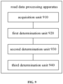
- FIG. 9 is a schematic diagram of a road data processing apparatus according to an embodiment of the present disclosure.
- the road data processing apparatus includes:
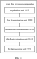
- FIG. 10 is a schematic diagram of a road data processing apparatus according to another embodiment of the present disclosure.
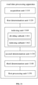
- the road data processing apparatus includes an acquisition unit 1010, a first determination unit 1020, a second determination unit 1030, and a third determination unit 1040.
- the acquisition unit 1010, the first determination unit 1020, the second determination unit 1030, and the third determination unit 1040 in FIG. 10 are same as or similar to the acquisition unit 910, the first determination unit 920, the second determination unit 930, and the third determination unit 940 in FIG. 9 .
- the above-mentioned apparatus further includes a first processing unit 1050 configured for: connecting road center points corresponding to all road vertical lines of the road unit, to obtain a road centerline of the road unit.
- the second determination unit 1030 is configured for:
- FIG. 11 is a schematic diagram of a road data processing apparatus according to another embodiment of the present disclosure.
- the road data processing apparatus includes an acquisition unit 1110, a first determination unit 1120, a second determination unit 1130, a third determination unit 1140, and a first processing unit 1150.
- the acquisition unit 1110, the first determination unit 1020, the second determination unit 1030, the third determination unit 1040, and the first processing unit 1150 in FIG. 11 are same as or similar to the acquisition unit 1010, the first determination unit 1020, the second determination unit 1030, the third determination unit 1040, and the first processing unit 1050 in FIG. 10 .
- the above-mentioned apparatus further includes an indexing unit 1160.
- the indexing unit 1160 includes: a dividing subunit 1161 configured for dividing the position data of the points of intersection corresponding to the road unit into a plurality of partition data, according to position information of the road; and an indexing subunit 1162 configured for indexing the partition data by using an index processing mechanism, to obtain index data; and the second determination unit 1130 is further configured for determining the width area of the road on the road vertical line, according to the position data of the points of intersection acquired from the index data.
- the indexing subunit 1162 is configured for: indexing the partition data by taking an identification of the road unit and a subscript corresponding to the road unit in the partition data as a key-value pair.
- the present disclosure also provides an electronic device, a readable storage medium, and a computer program product.
- FIG. 12 shows a schematic block diagram of an example electronic device 1200 that may be configured to implement embodiments of the present disclosure.
- the electronic device is intended to represent various forms of digital computers, such as laptop computers, desktop computers, workstations, personal digital assistants, servers, blade servers, mainframe computers, and other suitable computers.
- the electronic device may also represent various forms of mobile devices, such as a personal digital assistant, a cellular telephone, a smart phone, a wearable device, and other similar computing devices.
- the components shown herein, their connections and relationships, and their functions are by way of example only and are not intended to limit the implementations of the present disclosure described and/or claimed herein.
- the electronic device 1200 includes a computing unit 1201 that may perform various suitable actions and processes in accordance with computer programs stored in a read only memory (ROM) 1202 or computer programs loaded from a storage unit 1208 into a random access memory (RAM) 1203.
- ROM read only memory
- RAM random access memory
- various programs and data required for the operation of the electronic device 1200 may also be stored.
- the computing unit 1201, the ROM 1202, and the RAM 1203 are connected to each other through a bus 1204.
- An input/output (I/O) interface 1205 is also connected to the bus 1204.
- a plurality of components in the electronic device 1200 are connected to the I/O interface 1205, including: an input unit 1206, such as a keyboard, a mouse, etc.; an output unit 1207, such as various types of displays, speakers, etc.; a storage unit 1208, such as a magnetic disk, an optical disk, etc.; and a communication unit 1209, such as a network card, a modem, a wireless communication transceiver, etc.
- the communication unit 1209 allows the electronic device 1200 to exchange information/data with other devices over a computer network, such as the Internet, and/or various telecommunications networks.
- the computing unit 1201 may be various general purpose and/or special purpose processing assemblies having processing and computing capabilities. Some examples of the computing unit 1201 include, but are not limited to, a central processing unit (CPU), a graphics processing unit (GPU), various specialized artificial information (AI) computing chips, various computing units running machine learning model algorithms, a digital signal processor (DSP), and any suitable processor, controller, microcontroller, etc.
- the computing unit 1201 performs various methods and processing procedures described above, such as the road data processing method or the image processing method.
- the road data processing method or the image processing method may be implemented as computer software programs that are physically contained in a machine-readable medium, such as the storage unit 1208.
- some or all of the computer programs may be loaded into and/or installed on the electronic device 1200 via the ROM 1202 and/or the communication unit 1209.
- the computer programs are loaded into the RAM 1203 and executed by the computing unit 1201, one or more of operations of the above road data processing method or image processing method may be performed.
- the computing unit 1201 may be configured to perform the road data processing method or the image processing method in any other suitable manner (e.g., by means of a firmware).
- Various implementations of the systems and techniques described herein above may be implemented in a digital electronic circuit system, an integrated circuit system, a field programmable gate array (FPGA), an application specific integrated circuit (ASIC), an application specific standard product (ASSP), a system on a chip (SOC), a load programmable logic device (CPLD), a computer hardware, a firmware, a software, and/or a combination thereof.
- FPGA field programmable gate array
- ASIC application specific integrated circuit
- ASSP application specific standard product
- SOC system on a chip
- CPLD load programmable logic device
- These various implementations may include an implementation in one or more computer programs, which can be executed and/or interpreted on a programmable system including at least one programmable processor; the programmable processor may be a dedicated or general-purpose programmable processor and capable of receiving and transmitting data and instructions from and to a storage system, at least one input device, and at least one output device.
- the program codes for implementing the road data processing method or the image processing method of the present disclosure may be written in any combination of one or more programming languages. These program codes may be provided to a processor or controller of a general purpose computer, a special purpose computer, or other programmable data processing apparatus such that the program codes, when executed by the processor or controller, enable the functions/operations specified in the flowchart and/or the block diagram to be implemented.
- the program codes may be executed entirely on a machine, partly on a machine, partly on a machine as a stand-alone software package and partly on a remote machine, or entirely on a remote machine or server.
- the machine-readable medium may be a tangible medium that may contain or store programs for using by or in connection with an instruction execution system, apparatus or device.
- the machine-readable medium may be a machine-readable signal medium or a machine-readable storage medium.
- the machine-readable medium may include, but is not limited to, an electronic, magnetic, optical, electromagnetic, infrared, or semiconductor system, apparatus or device, or any suitable combination thereof.
- machine-readable storage medium may include one or more wires-based electrical connection, a portable computer diskette, a hard disk, a random access memory (RAM), a read-only memory (ROM), an erasable programmable read-only memory (EPROM or Flash memory), an optical fiber, a portable compact disk read-only memory (CD-ROM), an optical storage device, a magnetic storage device, or any suitable combination thereof.
- RAM random access memory
- ROM read-only memory
- EPROM or Flash memory erasable programmable read-only memory
- CD-ROM compact disk read-only memory
- magnetic storage device or any suitable combination thereof.
- a computer having: a display device (e. g., a cathode ray tube (CRT) or a liquid crystal display (LCD) monitor) for displaying information to the user; and a keyboard and a pointing device (e. g., a mouse or a trackball), through which the user can provide an input to the computer.
- a display device e. g., a cathode ray tube (CRT) or a liquid crystal display (LCD) monitor
- a keyboard and a pointing device e. g., a mouse or a trackball
- Other kinds of devices can also provide an interaction with the user.
- a feedback provided to the user may be any form of sensory feedback (e.g., visual feedback, auditory feedback, or tactile feedback); and an input from the user may be received in any form, including an acoustic input, a voice input or a tactile input.
- the systems and techniques described herein may be implemented in a computing system (e.g., as a data server) that includes a background component, or a computing system (e.g., an application server) that includes a middleware component, or a computing system (e.g., a user computer having a graphical user interface or a web browser through which a user may interact with implementations of the systems and techniques described herein) that includes a front-end component, or a computing system that includes any combination of such background components, middleware components, or front-end components.
- the components of the system may be connected to each other through a digital data communication in any form or medium (e.g., a communication network). Examples of the communication network may include a local area network (LAN), a wide area network (WAN), and the Internet.
- LAN local area network
- WAN wide area network
- the Internet the global information network
- the computer system may include a client and a server.
- the client and the server are typically remote from each other and typically interact via the communication network.
- the relationship of the client and the server is generated by computer programs running on respective computers and having a client-server relationship with each other.
Landscapes
- Engineering & Computer Science (AREA)
- Physics & Mathematics (AREA)
- Theoretical Computer Science (AREA)
- General Physics & Mathematics (AREA)
- Geometry (AREA)
- Multimedia (AREA)
- Evolutionary Computation (AREA)
- General Engineering & Computer Science (AREA)
- Computer Hardware Design (AREA)
- Data Mining & Analysis (AREA)
- Mathematical Analysis (AREA)
- Mathematical Optimization (AREA)
- Pure & Applied Mathematics (AREA)
- Computational Mathematics (AREA)
- Computer Networks & Wireless Communication (AREA)
- Evolutionary Biology (AREA)
- Bioinformatics & Computational Biology (AREA)
- Bioinformatics & Cheminformatics (AREA)
- Computer Vision & Pattern Recognition (AREA)
- Artificial Intelligence (AREA)
- Life Sciences & Earth Sciences (AREA)
- Probability & Statistics with Applications (AREA)
- Architecture (AREA)
- Structural Engineering (AREA)
- Civil Engineering (AREA)
- Automation & Control Theory (AREA)
- Aviation & Aerospace Engineering (AREA)
- Traffic Control Systems (AREA)
- Road Repair (AREA)
- Control Of Driving Devices And Active Controlling Of Vehicle (AREA)
Claims (7)
- Computerimplementiertes Straßendaten-Verarbeitungsverfahren, umfassend:Aufnehmen einer Straßeneinheit in einem Straßen-Netzwerk und von Bahnkurven von Fahrzeugen, welche sich auf einer Straße bewegen, welche durch die Straßeneinheit repräsentiert wird, wobei die Straßeneinheit ein erstes Liniensegment ist, welches die Straße in dem Straßen-Netzwerk repräsentiert, wobei die Bahnkurven in Fahrzeug-Bahnkurvendaten für eine Mehrzahl von aufeinander folgenden Tagen durch die Straße umfasst sind, welche durch die Straßeneinheit repräsentiert ist;Erstellen (S120) einer vertikalen Straßenlinie für die Straßeneinheit und Bestimmen von Punkten eines Schneidens der Bahnkurven und der vertikalen Straßenlinie,wobei die vertikale Straßenlinie zu einer Ebene gehört, wo die Straßeneinheit und die Bahnkurven angeordnet sind und die vertikale Straßenlinie orthogonal zu der Straßeneinheit ist;Bestimmen (S130) einer Breite der Straße an der vertikalen Straßenlinie gemäß Positionsdaten der Punkte des Schneidens, wobei die Breite ein zweites Liniensegment ist, welches sich entlang der vertikalen Straßenlinie erstreckt und mit der Straßeneinheit schneidet; undBestimmen (S140) eines Mittelpunkts des zweiten Liniensegments als einen Straßen-Mittelpunkt, welcher der vertikalen Straßenlinie entspricht,wobei das Bestimmen (S130) der Breite der Straße an der vertikalen Straßenlinie gemäß den Positionsdaten der Punkte des Schneidens umfasst: Durchführen (S410) einer Cluster-Analyse auf die Positionsdaten der Punkte des Schneidens durch Verwenden eines Gauß'schen Mischungsmodells, um einen Positionsbereich zu erhalten, welcher den Punkten des Schneidens unter einem vorbestimmten Konfidenzniveau entspricht; und Bestimmen (S420) des Positionsbereichs als die Breite der Straße an der vertikalen Straßenlinie,wobei das Verfahren ferner umfasst: Unterteilen der Positionsdaten der Punkte des Schneidens, welche der Straßeneinheit entsprechen, in eine Mehrzahl von Partitionsdaten gemäß Gitterregionen, zu welchen die Positionsdaten der Punkte des Schneidens gehören, gemäß Positionsinformationen der Straße; Speichern der Positionsdaten der Punkte des Schneidens in einem Dateisystem in einer Form einer Bildrahmen-Unterteilung; Indizieren der Partitionsdaten in jeder Partition durch Betrachten einer Identifikation der Straßeneinheit und einer Tiefstellung, welche der Straßeneinheit in den Partitionsdaten entspricht, als ein Schlüssel-Wert-Paar, um Indexdaten zu erhalten; und Bestimmen (S630) der Breite der Straße an der vertikalen Straßenlinie gemäß den Positionsdaten der Punkte des Schneidens, welche aus den Indexdaten erhalten werden.
- Verfahren nach Anspruch 1, ferner umfassend:
Verbinden von Straßen-Mittelpunkten, welche allen vertikalen Straßenlinien der Straßeneinheit entsprechen, um eine Straßen-Mittellinie der Straßeneinheit zu erhalten. - Straßendaten-Verarbeitungsvorrichtung, umfassend:eine Aufnahmeeinheit (910, 1010, 1110) welche zum Aufnehmen einer Straßeneinheit in einem Straßen-Netzwerk und von Bahnkurven von Fahrzeugen eingerichtet ist, welche sich auf einer Straße bewegen, welche durch die Straßeneinheit repräsentiert wird, wobei die Straßeneinheit ein erstes Liniensegment ist, welches die Straße in dem Straßen-Netzwerk repräsentiert, wobei die Bahnkurven in Fahrzeug-Bahnkurvendaten für eine Mehrzahl von aufeinander folgenden Tagen durch die Straße umfasst sind, welche durch die Straßeneinheit repräsentiert ist;eine erste Bestimmungseinheit (920, 1020, 1120), welche zum Erstellen einer vertikalen Straßenlinie für die Straßeneinheit und Bestimmen von Punkten eines Schneidens der Bahnkurven und der vertikalen Straßenlinie eingerichtet ist, wobei die vertikale Straßenlinie zu einer Ebene gehört, wo die Straßeneinheit und die Bahnkurven angeordnet sind und die vertikale Straßenlinie orthogonal zu der Straßeneinheit ist;eine zweite Bestimmungseinheit (930, 1030, 1130), welche zum Bestimmen einer Breite der Straße an der vertikalen Straßenlinie gemäß Positionsdaten der Punkte des Schneidens eingerichtet ist, wobei die Breite ein zweites Liniensegment ist, welches sich entlang der vertikalen Straßenlinie erstreckt und mit der Straßeneinheit schneidet; undeine dritte Bestimmungseinheit (940, 1040, 1140), welche zum Bestimmen eines Mittelpunkts des zweiten Liniensegments als einen Straßen-Mittelpunkt eingerichtet ist, welcher der vertikalen Straßenlinie entspricht,wobei die zweite Bestimmungseinheit (930, 1030, 1130) ferner eingerichtet ist zum: Durchführen einer Cluster-Analyse auf die Positionsdaten der Punkte des Schneidens durch Verwenden eines Gauß'schen Mischungsmodells, um einen Positionsbereich zu erhalten, welcher den Punkten des Schneidens unter einem vorbestimmten Konfidenzniveau entspricht; und Bestimmen des Positionsbereichs als die Breite der Straße an der vertikalen Straßenlinie,wobei die Vorrichtung ferner eine Indizierungseinheit (1160) umfasst, wobei die Indizierungseinheit (1160) umfasst: eine Unterteilung-Untereinheit (1161), welche zum Unterteilen der Positionsdaten der Punkte des Schneidens eingerichtet ist, welche der Straßeneinheit entsprechen, in eine Mehrzahl von Partitionsdaten gemäß Gitterregionen, zu welchen die Positionsdaten der Punkte des Schneidens gehören, gemäß Positionsinformationen der Straße, und Speichern der Positionsdaten der Punkte des Schneidens in einem Dateisystem in einer Form einer Bildrahmen-Unterteilung; sowie eine Indizierung-Untereinheit (1162),welche zum Indizieren der Partitionsdaten in jeder Partition durch Betrachten einer Identifikation der Straßeneinheit und einer Tiefstellung, welche der Straßeneinheit in den Partitionsdaten entspricht, als ein Schlüssel-Wert-Paar eingerichtet ist, um Indexdaten zu erhalten; und die zweite Bestimmungseinheit (930, 1030, 1130) ferner eingerichtet ist zum Bestimmen der Breite der Straße an der vertikalen Straßenlinie gemäß den Positionsdaten der Punkte des Schneidens, welche aus den Indexdaten erhalten werden.
- Vorrichtung nach Anspruch 3, ferner umfassend eine erste Verarbeitungseinheit (1050, 1150), welche eingerichtet ist zum:
Verbinden von Straßen-Mittelpunkten, welche allen vertikalen Straßenlinien der Straßeneinheit entsprechen, um eine Straßen-Mittellinie der Straßeneinheit zu erhalten. - Elektronische Vorrichtung, umfassend:wenigstens einen Prozessor; undeinen Speicher, welcher kommunikativ mit dem wenigstens einen Prozessor verbunden ist, wobei der Speicher Anweisungen speichert, welche von dem wenigstens einen Prozessor ausführbar sind, und die Anweisungen, wenn sie von dem wenigstens einen Prozessor ausgeführt werden, den wenigstens einen Prozessor dazu befähigen, das Verfahren nach einem der Ansprüche 1 bis 2 durchzuführen.
- Nichtflüchtiges computerlesbares Speichermedium, welches Computeranweisungen speichert, wobei die Computeranweisungen, wenn sie von einem Computer ausgeführt werden, den Computer dazu veranlassen, das Verfahren nach einem der Ansprüche 1 bis 2 durchzuführen.
- Computerprogramm-Produkt, welches ein Computerprogramm umfasst, wobei das Computerprogramm, wenn es von einem Prozessor ausgeführt wird, das Verfahren nach einem der Ansprüche 1 bis 2 implementiert.
Applications Claiming Priority (2)
| Application Number | Priority Date | Filing Date | Title |
|---|---|---|---|
| CN202110470264.3A CN113139258B (zh) | 2021-04-28 | 2021-04-28 | 道路数据处理方法、装置、设备及存储介质 |
| PCT/CN2021/129886 WO2022227487A1 (zh) | 2021-04-28 | 2021-11-10 | 道路数据处理方法、装置、设备及存储介质 |
Publications (3)
| Publication Number | Publication Date |
|---|---|
| EP4102391A1 EP4102391A1 (de) | 2022-12-14 |
| EP4102391A4 EP4102391A4 (de) | 2023-08-23 |
| EP4102391B1 true EP4102391B1 (de) | 2025-05-14 |
Family
ID=76816382
Family Applications (1)
| Application Number | Title | Priority Date | Filing Date |
|---|---|---|---|
| EP21887869.2A Active EP4102391B1 (de) | 2021-04-28 | 2021-11-10 | Verfahren und vorrichtung zur verarbeitung von strassendaten sowie vorrichtung und speichermedium |
Country Status (6)
| Country | Link |
|---|---|
| US (1) | US20240153265A1 (de) |
| EP (1) | EP4102391B1 (de) |
| JP (1) | JP2023534086A (de) |
| KR (1) | KR20220070041A (de) |
| CN (1) | CN113139258B (de) |
| WO (1) | WO2022227487A1 (de) |
Families Citing this family (3)
| Publication number | Priority date | Publication date | Assignee | Title |
|---|---|---|---|---|
| CN113139258B (zh) * | 2021-04-28 | 2024-01-09 | 北京百度网讯科技有限公司 | 道路数据处理方法、装置、设备及存储介质 |
| CN113362420B (zh) * | 2021-06-02 | 2023-08-29 | 北京百度网讯科技有限公司 | 道路标注生成方法、装置、设备以及存储介质 |
| CN119441375B (zh) * | 2024-11-04 | 2025-05-06 | 北京华如科技股份有限公司 | 一种用于要素索引的数据处理方法及装置 |
Family Cites Families (23)
| Publication number | Priority date | Publication date | Assignee | Title |
|---|---|---|---|---|
| WO2006060518A2 (en) * | 2004-11-30 | 2006-06-08 | Circumnav Networks, Inc. | Methods for deducing road geometry and connectivity |
| US7516041B2 (en) * | 2005-10-14 | 2009-04-07 | Dash Navigation, Inc. | System and method for identifying road features |
| JP2008241592A (ja) * | 2007-03-28 | 2008-10-09 | Matsushita Electric Ind Co Ltd | ナビゲーション装置、ナビゲーション方法、及びナビゲーションプログラム |
| WO2008130219A1 (en) * | 2007-04-19 | 2008-10-30 | Tele Atlas B.V. | Method of and apparatus for producing road information |
| US8315756B2 (en) * | 2009-08-24 | 2012-11-20 | Toyota Motor Engineering and Manufacturing N.A. (TEMA) | Systems and methods of vehicular path prediction for cooperative driving applications through digital map and dynamic vehicle model fusion |
| DE102012004396A1 (de) * | 2012-03-03 | 2013-09-05 | Volkswagen Aktiengesellschaft | Verfahren und Vorrichtung zum Erfassen von Objekten in einer Umgebung eines Fahrzeugs |
| US20140095062A1 (en) * | 2012-09-28 | 2014-04-03 | Hewlett-Packard Development Company, L.P. | Road Maps from Clusters of Line Segments of Multiple Sources |
| US9165477B2 (en) * | 2013-12-06 | 2015-10-20 | Vehicle Data Science Corporation | Systems and methods for building road models, driver models, and vehicle models and making predictions therefrom |
| WO2015098280A1 (ja) * | 2013-12-27 | 2015-07-02 | 株式会社シーズ・ラボ | 地図データ更新装置 |
| US10533863B2 (en) * | 2014-10-10 | 2020-01-14 | Here Global B.V. | Apparatus and associated methods for use in lane-level mapping of road intersections |
| US10444020B2 (en) * | 2015-06-03 | 2019-10-15 | Here Global B.V. | Method and apparatus for defining road geometry from probe data |
| US10546400B2 (en) * | 2015-06-03 | 2020-01-28 | Here Global B.V. | Method and apparatus for defining bi-directional road geometry from probe data |
| US10013610B2 (en) * | 2015-10-23 | 2018-07-03 | Nokia Technologies Oy | Integration of positional data and overhead images for lane identification |
| CN108664016B (zh) * | 2017-03-31 | 2020-09-15 | 腾讯科技(深圳)有限公司 | 确定车道中心线的方法及装置 |
| DE102017209346A1 (de) * | 2017-06-01 | 2019-01-10 | Robert Bosch Gmbh | Verfahren und Vorrichtung zur Erstellung einer fahrspurgenauen Straßenkarte |
| CN109208416A (zh) * | 2017-07-01 | 2019-01-15 | 都快通(北京)交通疏导设备有限公司 | 一种加入小循环系统的复合式城市交通系统 |
| CN109752009B (zh) * | 2017-11-03 | 2023-01-06 | 华为技术有限公司 | 路口区域路网数据生成方法及装置 |
| US10921135B2 (en) * | 2018-10-12 | 2021-02-16 | Baidu Usa Llc | Real-time map generation scheme for autonomous vehicles based on prior driving trajectories |
| CN110389995B (zh) * | 2019-07-31 | 2023-02-21 | 北京百度网讯科技有限公司 | 车道信息检测方法、装置、设备和介质 |
| US11654918B2 (en) * | 2019-08-06 | 2023-05-23 | GM Global Technology Operations LLC | Estimation of road centerline based on vehicle telemetry |
| CN111858801B (zh) * | 2020-06-30 | 2024-03-22 | 北京百度网讯科技有限公司 | 道路信息的挖掘方法、装置、电子设备及存储介质 |
| CN112257772B (zh) * | 2020-10-19 | 2022-05-13 | 武汉中海庭数据技术有限公司 | 一种道路增减区间切分方法、装置、电子设备及存储介质 |
| CN113139258B (zh) * | 2021-04-28 | 2024-01-09 | 北京百度网讯科技有限公司 | 道路数据处理方法、装置、设备及存储介质 |
-
2021
- 2021-04-28 CN CN202110470264.3A patent/CN113139258B/zh active Active
- 2021-11-10 WO PCT/CN2021/129886 patent/WO2022227487A1/zh not_active Ceased
- 2021-11-10 KR KR1020227015748A patent/KR20220070041A/ko not_active Withdrawn
- 2021-11-10 EP EP21887869.2A patent/EP4102391B1/de active Active
- 2021-11-10 US US17/775,606 patent/US20240153265A1/en not_active Abandoned
- 2021-11-10 JP JP2022520348A patent/JP2023534086A/ja active Pending
Also Published As
| Publication number | Publication date |
|---|---|
| CN113139258B (zh) | 2024-01-09 |
| KR20220070041A (ko) | 2022-05-27 |
| JP2023534086A (ja) | 2023-08-08 |
| US20240153265A1 (en) | 2024-05-09 |
| WO2022227487A1 (zh) | 2022-11-03 |
| EP4102391A1 (de) | 2022-12-14 |
| EP4102391A4 (de) | 2023-08-23 |
| CN113139258A (zh) | 2021-07-20 |
Similar Documents
| Publication | Publication Date | Title |
|---|---|---|
| Chen et al. | TrajCompressor: An online map-matching-based trajectory compression framework leveraging vehicle heading direction and change | |
| US11105638B2 (en) | Method, apparatus, and computer readable storage medium for updating electronic map | |
| US9880012B2 (en) | Hybrid road network and grid based spatial-temporal indexing under missing road links | |
| EP4102391B1 (de) | Verfahren und vorrichtung zur verarbeitung von strassendaten sowie vorrichtung und speichermedium | |
| CN112712690B (zh) | 车辆电子围栏方法、装置、电子设备 | |
| US10452661B2 (en) | Automated database schema annotation | |
| CN114626169B (zh) | 交通路网优化方法、装置、设备、可读存储介质及产品 | |
| US12313426B2 (en) | Method of updating map data, electronic device and storage medium | |
| CN113139032B (zh) | 地理位置的搜索方法、装置、电子设备及存储介质 | |
| CN103530356A (zh) | 电子地图服务平台以及电子地图数据联动展现的方法 | |
| CN109041218A (zh) | 一种预测用户位置的方法和智能硬件 | |
| CN114625774A (zh) | 数据处理方法、装置、计算机存储介质及计算机程序产品 | |
| CN116465394B (zh) | 基于车辆轨迹数据的路网结构生成方法及装置 | |
| US20220381574A1 (en) | Multipath generation method, apparatus, device and storage medium | |
| US9436715B2 (en) | Data management apparatus and data management method | |
| Shrivastava | A review of spatial big data platforms, opportunities, and challenges | |
| CN115265544A (zh) | 基于视觉地图的定位方法及装置 | |
| CN109241207B (zh) | 一种在地图上显示数据的方法及装置 | |
| CN115712667A (zh) | 一种图数据融合分析方法、装置及存储介质 | |
| Zhang et al. | U2sod-db: a database system to manage large-scale ubiquitous urban sensing origin-destination data | |
| CN114579594A (zh) | 信息更新方法、装置、电子设备以及存储介质 | |
| Liu et al. | A Disaster Information Service for Damaged Road Networks Using Dynamic Segmentation | |
| CN114330807A (zh) | 路线的确定方法、装置和电子设备 | |
| CN114199228B (zh) | 地图数据生成方法、装置、电子设备和存储介质 | |
| CN119377338B (zh) | 地理对象处理方法、装置、电子设备和计算机存储介质 |
Legal Events
| Date | Code | Title | Description |
|---|---|---|---|
| STAA | Information on the status of an ep patent application or granted ep patent |
Free format text: STATUS: UNKNOWN |
|
| STAA | Information on the status of an ep patent application or granted ep patent |
Free format text: STATUS: THE INTERNATIONAL PUBLICATION HAS BEEN MADE |
|
| PUAI | Public reference made under article 153(3) epc to a published international application that has entered the european phase |
Free format text: ORIGINAL CODE: 0009012 |
|
| STAA | Information on the status of an ep patent application or granted ep patent |
Free format text: STATUS: REQUEST FOR EXAMINATION WAS MADE |
|
| 17P | Request for examination filed |
Effective date: 20220510 |
|
| AK | Designated contracting states |
Kind code of ref document: A1 Designated state(s): AL AT BE BG CH CY CZ DE DK EE ES FI FR GB GR HR HU IE IS IT LI LT LU LV MC MK MT NL NO PL PT RO RS SE SI SK SM TR |
|
| A4 | Supplementary search report drawn up and despatched |
Effective date: 20230721 |
|
| RIC1 | Information provided on ipc code assigned before grant |
Ipc: G06F 111/08 20200101ALN20230717BHEP Ipc: G06V 20/56 20220101ALI20230717BHEP Ipc: G06F 30/15 20200101ALI20230717BHEP Ipc: G06F 30/18 20200101AFI20230717BHEP |
|
| STAA | Information on the status of an ep patent application or granted ep patent |
Free format text: STATUS: EXAMINATION IS IN PROGRESS |
|
| 17Q | First examination report despatched |
Effective date: 20240517 |
|
| DAV | Request for validation of the european patent (deleted) | ||
| DAX | Request for extension of the european patent (deleted) | ||
| GRAP | Despatch of communication of intention to grant a patent |
Free format text: ORIGINAL CODE: EPIDOSNIGR1 |
|
| STAA | Information on the status of an ep patent application or granted ep patent |
Free format text: STATUS: GRANT OF PATENT IS INTENDED |
|
| INTG | Intention to grant announced |
Effective date: 20241209 |
|
| GRAS | Grant fee paid |
Free format text: ORIGINAL CODE: EPIDOSNIGR3 |
|
| GRAA | (expected) grant |
Free format text: ORIGINAL CODE: 0009210 |
|
| STAA | Information on the status of an ep patent application or granted ep patent |
Free format text: STATUS: THE PATENT HAS BEEN GRANTED |
|
| AK | Designated contracting states |
Kind code of ref document: B1 Designated state(s): AL AT BE BG CH CY CZ DE DK EE ES FI FR GB GR HR HU IE IS IT LI LT LU LV MC MK MT NL NO PL PT RO RS SE SI SK SM TR |
|
| RAP3 | Party data changed (applicant data changed or rights of an application transferred) |
Owner name: BEIJING BAIDU NETCOMSCIENCE TECHNOLOGY CO., LTD. |
|
| REG | Reference to a national code |
Ref country code: GB Ref legal event code: FG4D |
|
| REG | Reference to a national code |
Ref country code: CH Ref legal event code: EP |
|
| REG | Reference to a national code |
Ref country code: IE Ref legal event code: FG4D |
|
| REG | Reference to a national code |
Ref country code: DE Ref legal event code: R096 Ref document number: 602021030934 Country of ref document: DE |
|
| P01 | Opt-out of the competence of the unified patent court (upc) registered |
Free format text: CASE NUMBER: APP_22030/2025 Effective date: 20250508 |
|
| REG | Reference to a national code |
Ref country code: NL Ref legal event code: MP Effective date: 20250514 |
|
| PG25 | Lapsed in a contracting state [announced via postgrant information from national office to epo] |
Ref country code: PT Free format text: LAPSE BECAUSE OF FAILURE TO SUBMIT A TRANSLATION OF THE DESCRIPTION OR TO PAY THE FEE WITHIN THE PRESCRIBED TIME-LIMIT Effective date: 20250915 Ref country code: FI Free format text: LAPSE BECAUSE OF FAILURE TO SUBMIT A TRANSLATION OF THE DESCRIPTION OR TO PAY THE FEE WITHIN THE PRESCRIBED TIME-LIMIT Effective date: 20250514 Ref country code: ES Free format text: LAPSE BECAUSE OF FAILURE TO SUBMIT A TRANSLATION OF THE DESCRIPTION OR TO PAY THE FEE WITHIN THE PRESCRIBED TIME-LIMIT Effective date: 20250514 |
|
| REG | Reference to a national code |
Ref country code: LT Ref legal event code: MG9D |
|
| PG25 | Lapsed in a contracting state [announced via postgrant information from national office to epo] |
Ref country code: NO Free format text: LAPSE BECAUSE OF FAILURE TO SUBMIT A TRANSLATION OF THE DESCRIPTION OR TO PAY THE FEE WITHIN THE PRESCRIBED TIME-LIMIT Effective date: 20250814 Ref country code: GR Free format text: LAPSE BECAUSE OF FAILURE TO SUBMIT A TRANSLATION OF THE DESCRIPTION OR TO PAY THE FEE WITHIN THE PRESCRIBED TIME-LIMIT Effective date: 20250815 |
|
| PG25 | Lapsed in a contracting state [announced via postgrant information from national office to epo] |
Ref country code: NL Free format text: LAPSE BECAUSE OF FAILURE TO SUBMIT A TRANSLATION OF THE DESCRIPTION OR TO PAY THE FEE WITHIN THE PRESCRIBED TIME-LIMIT Effective date: 20250514 Ref country code: PL Free format text: LAPSE BECAUSE OF FAILURE TO SUBMIT A TRANSLATION OF THE DESCRIPTION OR TO PAY THE FEE WITHIN THE PRESCRIBED TIME-LIMIT Effective date: 20250514 |
|
| REG | Reference to a national code |
Ref country code: AT Ref legal event code: MK05 Ref document number: 1795425 Country of ref document: AT Kind code of ref document: T Effective date: 20250514 |
|
| PG25 | Lapsed in a contracting state [announced via postgrant information from national office to epo] |
Ref country code: BG Free format text: LAPSE BECAUSE OF FAILURE TO SUBMIT A TRANSLATION OF THE DESCRIPTION OR TO PAY THE FEE WITHIN THE PRESCRIBED TIME-LIMIT Effective date: 20250514 |
|
| PG25 | Lapsed in a contracting state [announced via postgrant information from national office to epo] |
Ref country code: HR Free format text: LAPSE BECAUSE OF FAILURE TO SUBMIT A TRANSLATION OF THE DESCRIPTION OR TO PAY THE FEE WITHIN THE PRESCRIBED TIME-LIMIT Effective date: 20250514 |
|
| PG25 | Lapsed in a contracting state [announced via postgrant information from national office to epo] |
Ref country code: AT Free format text: LAPSE BECAUSE OF FAILURE TO SUBMIT A TRANSLATION OF THE DESCRIPTION OR TO PAY THE FEE WITHIN THE PRESCRIBED TIME-LIMIT Effective date: 20250514 |
|
| PG25 | Lapsed in a contracting state [announced via postgrant information from national office to epo] |
Ref country code: RS Free format text: LAPSE BECAUSE OF FAILURE TO SUBMIT A TRANSLATION OF THE DESCRIPTION OR TO PAY THE FEE WITHIN THE PRESCRIBED TIME-LIMIT Effective date: 20250814 |
|
| PG25 | Lapsed in a contracting state [announced via postgrant information from national office to epo] |
Ref country code: IS Free format text: LAPSE BECAUSE OF FAILURE TO SUBMIT A TRANSLATION OF THE DESCRIPTION OR TO PAY THE FEE WITHIN THE PRESCRIBED TIME-LIMIT Effective date: 20250914 |
|
| PG25 | Lapsed in a contracting state [announced via postgrant information from national office to epo] |
Ref country code: LV Free format text: LAPSE BECAUSE OF FAILURE TO SUBMIT A TRANSLATION OF THE DESCRIPTION OR TO PAY THE FEE WITHIN THE PRESCRIBED TIME-LIMIT Effective date: 20250514 |