EP3971731A1 - Verfahren und vorrichtung zur verarbeitung von koordinatendaten auf zaunadressenbasis und computervorrichtung - Google Patents
Verfahren und vorrichtung zur verarbeitung von koordinatendaten auf zaunadressenbasis und computervorrichtung Download PDFInfo
- Publication number
- EP3971731A1 EP3971731A1 EP20805432.0A EP20805432A EP3971731A1 EP 3971731 A1 EP3971731 A1 EP 3971731A1 EP 20805432 A EP20805432 A EP 20805432A EP 3971731 A1 EP3971731 A1 EP 3971731A1
- Authority
- EP
- European Patent Office
- Prior art keywords
- address
- node
- text
- extended
- geographic coordinates
- Prior art date
- Legal status (The legal status is an assumption and is not a legal conclusion. Google has not performed a legal analysis and makes no representation as to the accuracy of the status listed.)
- Granted
Links
Images


Classifications
-
- G—PHYSICS
- G06—COMPUTING OR CALCULATING; COUNTING
- G06F—ELECTRIC DIGITAL DATA PROCESSING
- G06F16/00—Information retrieval; Database structures therefor; File system structures therefor
- G06F16/30—Information retrieval; Database structures therefor; File system structures therefor of unstructured textual data
- G06F16/38—Retrieval characterised by using metadata, e.g. metadata not derived from the content or metadata generated manually
- G06F16/387—Retrieval characterised by using metadata, e.g. metadata not derived from the content or metadata generated manually using geographical or spatial information, e.g. location
-
- G—PHYSICS
- G06—COMPUTING OR CALCULATING; COUNTING
- G06F—ELECTRIC DIGITAL DATA PROCESSING
- G06F16/00—Information retrieval; Database structures therefor; File system structures therefor
- G06F16/20—Information retrieval; Database structures therefor; File system structures therefor of structured data, e.g. relational data
- G06F16/29—Geographical information databases
-
- G—PHYSICS
- G06—COMPUTING OR CALCULATING; COUNTING
- G06F—ELECTRIC DIGITAL DATA PROCESSING
- G06F16/00—Information retrieval; Database structures therefor; File system structures therefor
- G06F16/30—Information retrieval; Database structures therefor; File system structures therefor of unstructured textual data
- G06F16/33—Querying
- G06F16/3331—Query processing
- G06F16/334—Query execution
- G06F16/3344—Query execution using natural language analysis
-
- G—PHYSICS
- G06—COMPUTING OR CALCULATING; COUNTING
- G06F—ELECTRIC DIGITAL DATA PROCESSING
- G06F16/00—Information retrieval; Database structures therefor; File system structures therefor
- G06F16/30—Information retrieval; Database structures therefor; File system structures therefor of unstructured textual data
- G06F16/33—Querying
- G06F16/335—Filtering based on additional data, e.g. user or group profiles
-
- G—PHYSICS
- G06—COMPUTING OR CALCULATING; COUNTING
- G06F—ELECTRIC DIGITAL DATA PROCESSING
- G06F16/00—Information retrieval; Database structures therefor; File system structures therefor
- G06F16/30—Information retrieval; Database structures therefor; File system structures therefor of unstructured textual data
- G06F16/35—Clustering; Classification
-
- G—PHYSICS
- G06—COMPUTING OR CALCULATING; COUNTING
- G06F—ELECTRIC DIGITAL DATA PROCESSING
- G06F16/00—Information retrieval; Database structures therefor; File system structures therefor
- G06F16/90—Details of database functions independent of the retrieved data types
- G06F16/907—Retrieval characterised by using metadata, e.g. metadata not derived from the content or metadata generated manually
- G06F16/909—Retrieval characterised by using metadata, e.g. metadata not derived from the content or metadata generated manually using geographical or spatial information, e.g. location
-
- G—PHYSICS
- G06—COMPUTING OR CALCULATING; COUNTING
- G06F—ELECTRIC DIGITAL DATA PROCESSING
- G06F40/00—Handling natural language data
- G06F40/20—Natural language analysis
- G06F40/237—Lexical tools
- G06F40/247—Thesauruses; Synonyms
-
- G—PHYSICS
- G06—COMPUTING OR CALCULATING; COUNTING
- G06F—ELECTRIC DIGITAL DATA PROCESSING
- G06F40/00—Handling natural language data
- G06F40/20—Natural language analysis
- G06F40/279—Recognition of textual entities
- G06F40/289—Phrasal analysis, e.g. finite state techniques or chunking
-
- G—PHYSICS
- G06—COMPUTING OR CALCULATING; COUNTING
- G06F—ELECTRIC DIGITAL DATA PROCESSING
- G06F40/00—Handling natural language data
- G06F40/30—Semantic analysis
Definitions
- the present disclosure relates to the field of computer technologies, and in particular, to a fence address-based coordinate data processing method and apparatus, and a computer device.
- Geocoding is often required in scenarios such as logistics transportation and route navigation.
- Geocoding refers to converting geographic location information described as an address into geographic coordinates that can be used for a geographic information system (GIS).
- GIS geographic information system
- a waybill address is converted into geographic coordinates, and express items are automatically sorted according to the geographic coordinates; and a destination address is converted into geographic coordinates in UAV navigation, and flight route navigation is performed according to the geographic coordinates.
- GIS geographic information system
- text error correction processing is performed on the geographic location information based on an error correction model, and then geocoding is performed according to the geographic location information after the error correction processing.
- This manner not only requires extensive labeling of sample data for model training, resulting in low processing efficiency is reduced; and because the sample coverage is limited, the processing effect is poor.
- a fence address-based coordinate data processing method and apparatus a computer-readable storage medium, and a computer device are provided, which may improve processing efficiency and a processing effect.
- a fence address-based coordinate data processing method including: obtaining an address text and a fence identifier corresponding to the address text; performing semantic extension on the address text to obtain a plurality of extended addresses; converting each of the extended addresses into corresponding geographic coordinates; recognizing a key address element in the plurality of extended addresses; screening the geographic coordinates depending on whether an extended address corresponding to a geographic coordinate includes the recognized key address element and whether the geographic coordinate is located in a target fence corresponding to the fence identifier; and determining, according to a clustering feature of each of the screened geographic coordinates, one of the screened geographic coordinates as a processed coordinate.
- a fence address-based coordinate data processing apparatus including: an address obtaining module, configured to obtain an address text and a fence identifier corresponding to the address text; a coordinate extension module, configured to perform semantic extension on the address text to obtain a plurality of extended addresses; and convert each of the extended addresses into corresponding geographic coordinates; and a coordinate screening module, configured to recognize a key address element in the plurality of extended addresses; screen the geographic coordinates depending on whether an extended address corresponding to a geographic coordinate includes the recognized key address element and whether the geographic coordinate is located in a target fence corresponding to the fence identifier; and determine, according to a clustering feature of each of the screened geographic coordinates, one of the screened geographic coordinates as a processed coordinate.
- a computer-readable storage medium storing a computer program, the computer program, when executed by a processor, causing the processor to perform the steps of the fence address-based coordinate data processing method.
- a computer device including a memory and a processor, the memory storing a computer program, the computer program, when executed by the processor, causing the processor to perform the steps of the fence address-based coordinate data processing method.
- the computer-readable storage medium, and the computer device by performing semantic extension on an obtained address text, a plurality of extended addresses may be obtained, and the obtained extended addresses may be respectively converted into corresponding geographic coordinates, thereby obtaining a plurality of possible geographic coordinates.
- a plurality of extended addresses may be obtained, and the obtained extended addresses may be respectively converted into corresponding geographic coordinates, thereby obtaining a plurality of possible geographic coordinates.
- region constraint is performed based on a target fence, the geographic coordinates are screened depending on whether the recognized key address element is included, and some invalid geographic coordinates may be filtered.
- Final geographic coordinates are determined based on a clustering feature in the geographic coordinates obtained by the screening and filtering, and the accuracy of processed coordinates can be improved based on the multi-level screening and a high aggregation requirement.
- the corresponding processed coordinates may be quickly fed back by only providing the address text, the costs of manually obtaining the processed coordinates are reduced, and the timeliness of processing a coordinate data processing task can be improved.
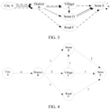
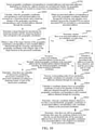
- FIG. 1 is a diagram of an application environment of a fence address-based coordinate data processing method according to an embodiment.
- the fence address-based coordinate data processing method is applicable to a fence address-based coordinate data processing system.
- the fence address-based coordinate data processing system includes a terminal 110 and a server 120.
- the terminal 110 and the server 120 are connected by a network.
- the fence address-based coordinate data processing method may be completed in the terminal 110 or the server 120.
- the terminal 110 may acquire an address text that needs to obtain geographic coordinates and a corresponding fence identifier, and then the geographic coordinates are processed in the terminal 110 by using the fence address-based coordinate data processing method.
- the terminal 110 may send the address text and the fence identifier to the server 120 through a network connection, and the server 120 processes the geographic coordinates by using the fence address-based coordinate data processing method.
- the terminal 110 may be a desktop terminal or a mobile terminal, for example, the mobile terminal may be at least one of a mobile phone, a tablet computer, a notebook computer, and the like.
- the server 120 may be implemented by an independent server or a server cluster that includes a plurality of servers.
- the processing the geographic coordinates may be extracting the geographic coordinates.
- the fence address-based coordinate data processing method may be a method for extracting, according to an address text and a corresponding fence identifier, geographic coordinates corresponding to the address text.
- the processing the geographic coordinates may be performing error correction on existing geographic coordinates of an address text.
- the fence address-based coordinate data processing method may be a method for performing, according to an address text and a corresponding fence identifier, error correction on existing geographic coordinates of the address text.
- the processing the geographic coordinates may be alternatively other processing of the geographic coordinates. This is not limited in this embodiment of the present disclosure.
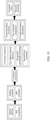
- a fence address-based coordinate data processing method is provided. This embodiment is described by using an example in which the method is applicable to the terminal 110 or the server 120 in FIG. 1 .
- the fence address-based coordinate data processing method includes the following steps.
- the address text is a text used for describing geographical location information of a point of interest (POI), for example, "Store E, Street D, Village C, District B, City A".
- POI refers to a landmark, an attraction, or the like in a geographic information system, for example, a government department of a region, a commercial organization (for example, a gas station, a department store, a supermarket, a restaurant, a hotel, a convenience store, or a hospital), places of interest, a tourist attraction (for example, a park or a public toilet), and a transportation facility (for example, a station, a parking lot, a toll station, a speed limit sign).
- the "Store E” is a POI entity.
- the POI entity refers to a text fragment in the address text for describing a name of the POI.
- the fence identifier is information that can uniquely identify a geo-fencing, for example, a fence code, a fence name, or a fence sequence number.
- the geo-fencing refers to a virtual geographic boundary formed by using a virtual fence. In a digital map, the geo-fencing may be a closed contour enclosed by a plurality of continuous coordinate points.
- the terminal may receive an automatic notification and an alarm. Based on a geo-fencing technology, automatic registration may be implemented when a user enters a particular region.
- the geo-fencing may be a basic distribution unit applied to a logistics and transportation industry.
- a logistics enterprise distributes a corresponding waybill to a corresponding fence distribution station according to a corresponding fence adapted to a waybill address.
- Different logistics enterprises may adopt different fence systems, that is, different fences have different fence boundaries and fence identifiers.
- the geo-fencing may be alternatively a basic no-fly unit or the like that is applied to limit the entry of an unmanned aerial vehicle into a high-risk region.
- a computer device receives an address text reported by a terminal.
- the address text may be an address text reported by the terminal, or the address text may be an address text on which geographic coordinates extraction needs to be performed. For example, when a user performs navigation by using a map application, according to an address text inputted by the user, geographic coordinates of the address text may be obtained, to relatively accurately instruct the user to drive to a destination.
- the address text may be an address text on which coordinate error correction needs to be performed.
- Reported information includes an address text corresponding to the waybill address in which a sorting error occurs and a fence identifier of a correct fence distribution station to which the waybill address is actually to be sorted.
- the address text may be alternatively obtained from another computer device in a communication manner such as a universal serial bus (USB) interface connection or a network connection.
- USB universal serial bus
- the semantic extension refers to a process of predicting, by deleting, extending, or replacing an address element of an address text, other more address texts that can indicate address location information similar to that of the address text.
- the address element refers to a text fragment in the address text for describing an address location.
- the extended address refers to a new address text obtained through the semantic extension.
- the "extended address” mentioned herein and below includes the "address text”.
- the computer device splits the address text into a plurality of text words and screens the text texts to obtain a text word belonging to the address element.
- the text word belonging to the address element refers to valid information that can describe an address location.
- the "Street D" in the address text is a text word belonging to the address element
- the "Please directly distribute it to the upstairs" in the address text is a text word that does not belong to the address element.
- the computer device performs role annotation on each address element, that is, determines an address role of each address element.
- the address role refers to a semantic category of a corresponding address element in the address text.
- the address role may include a city, a county, a town street, a road, a village, a POI, a building number, a door number, and the like.
- the deleting an address element refers to deleting address elements corresponding to one or more address roles in the address text.
- the computer device records a plurality of address roles and information about whether each address role is deletable during semantic extension.
- the computer device deletes corresponding address elements in the address text according to one or more deletable address roles. For example, if the "Village" belongs to a deletable address role, the address text in the foregoing example may be extended as " Store E, Street D, District B, City A".
- the extending an address element refers to inserting address elements corresponding to one or more address roles into the address text.
- the address role corresponding to the inserted address element may be a missing address role in the address text.
- the "Road” address role is missing in the address text in the foregoing example, and an address element "Road F" of the "Road” may be inserted in a corresponding location of the address text, to obtain an extended address " Store E, Road F, Street D, Village C, District B, City A".
- the replacing an address element refers to replacing an address element corresponding to an address role in the address text with another synonymous address element or alias address element of the same address role.
- the "Street D" in the address text in the foregoing example may be replaced by a synonymous address element "Avenue D”
- the "Store E” may be replaced by a synonymous address element "Shop E”, to obtain an extended address " Store E, Street D, Village C, District B, City A", " Shop E, Avenue D, Village C, District B, City A", and " Shop E, Street D, Village C, District B, City A ".
- the geographic coordinates refer to spherical coordinates (lng, lat) representing a location of a ground point by using a longitude lng and a latitude lat.
- the geographic coordinates may be long latitude of astronomy, geodetic longitude and latitude, or geocentric longitude and latitude.
- the computer device converts each of the extended addresses into corresponding geographic coordinates based on an address coding service.
- the geographic coordinates obtained by using the geocoding service are in one-to-one correspondence with the extended addresses.
- the computer device may alternatively search for geographic coordinates corresponding to each of extended addresses based on a coordinate retrieval service.
- the geographic coordinates obtained by using the coordinate retrieval service and the extended addresses may be in a one-to-one relationship or may be in a many-to-one relationship.
- one or more geographic coordinates corresponding to each extended address may be obtained based on the coordinate retrieval service.
- Different coordinate retrieval service providers provide different coordinate retrieval manners. For example, a coordinate retrieval operator 1, a coordinate retrieval operator 2, and the like provide different coordinate retrieval manners.
- the key address element refers to an address element that can cause address location information described by the address text to be in a converged state.
- the converged state refers to a state in which a possible region may be accurately positioned from a large quantity of dispersed possible regions.
- the key address element may be a POI prefix that can narrow down a large quantity of POIs of geographic location to one or several POIs.
- the recognizing a key address element in the extended addresses in S208 refers to: recognizing a key address element of each of the plurality of extended addresses obtained in S204. Therefore, the obtained key address element includes the key address element recognized in each extended address.
- S210 Screen corresponding geographic coordinates depending on whether an extended address corresponding to the geographic coordinates includes the recognized key address element and whether the geographic coordinates are located in a target fence corresponding to the fence identifier.
- the geographic coordinates are screened depending on whether an extended address corresponding to a geographic coordinate includes the recognized key address element and whether the geographic coordinate is located in a target fence corresponding to the fence identifier.
- the computer device traverses the plurality of extended addresses, and recognizes whether a current extended address includes all key address elements, all the key address elements being all key address elements obtained through the recognition. If the current extended address includes all the key address elements, the computer device retains geographic coordinates corresponding to the current extended address; and if the current extended address does not include all the key address elements, the geographic coordinates corresponding to the current extended address are deleted.
- the computer device recognizes whether the geographic coordinates are in a target fence based on a ray method.
- the target fence is displayed in the form of an irregular polygon in a digital map.
- Each extended address may be displayed in the form of a coordinate point according to a location of corresponding geographic coordinates in the digital map.
- the ray method refers to drawing a ray along an X axis from a coordinate point corresponding to the current extended address, sequentially determining an intersection of the ray and each edge of the target fence, and counting a quantity of intersections. If the quantity of intersections is an odd number, it indicates that the coordinate point corresponding to the extended address is inside the target fence; and if the quantity of intersections is an even number, it indicates that the coordinate point corresponding to the extended address is outside the target fence.
- the computer device may recognize whether geographic coordinates corresponding to an extended address are in the target fence according to an R-tree indexing method.
- the R-tree indexing method refers to approximately replacing the polygon with a minimum bounding rectangle, constructing an R index tree, and determining, according to the R index tree, whether a coordinate point corresponding to an extended address is covered by the bounding rectangle. If the coordinate point is covered by the bounding rectangle, it indicates that the coordinate point corresponding to the extended address is inside the target fence; otherwise, it indicates that the coordinate point corresponding to the extended address is outside the target fence.
- the computer device performs, depending on whether coordinate points corresponding to the extended addresses fall within the target fence, secondary screening on each extended address obtained through the screening, and only retains geographic coordinates including all the key address elements and falling within the target fence, the geographic coordinates including all the key address elements referring to that the extended addresses corresponding to the geographic coordinates include all the key address elements.
- S212 Determine, according to a clustering feature of the geographic coordinates, geographic coordinates obtained through the screening as processed coordinates. That is, the geographic coordinates obtained through the screening are determined as processed coordinates according to a clustering feature of each of the geographic coordinates obtained through the screening.
- the determining, according to a clustering feature of the geographic coordinates, geographic coordinates obtained through the screening as processed coordinates may include: determining, according to the clustering feature of the geographic coordinates, geographic coordinates obtained through the screening as corrected coordinates.
- the clustering feature is a feature such as a Gaussian density distribution value representing a clustering feature of geographic coordinates.
- a larger Gaussian density distribution value indicates more aggregation of corresponding geographic coordinates, and the geographic coordinates may be used as a cluster center point.
- the cluster center point refers to a geographic coordinate point with a highest aggregation in a plurality of geographic coordinate points.
- the computer device calculates a clustering feature of each of the geographic coordinates by using a clustering algorithm, to determine a cluster center point in the plurality of geographic coordinates.
- the clustering algorithm is, for example, a division-based clustering method (k-means), a fuzzy clustering algorithm (fuzzycluster), a density-based spatial clustering of application with noise (DBSCAN), or a clustering algorithm by fast search and find of density peaks.
- the computer device further screens, according to the clustering feature, the plurality of geographic coordinates obtained through the screening, to obtain geographic coordinates with a highest aggregation and filters noise data, so that the geographic coordinates obtained through the screening are valid, thereby improving the accuracy of a coordinate data processing result.
- a plurality of extended addresses may be obtained, and the obtained extended addresses may be respectively converted into corresponding geographic coordinates, thereby obtaining a plurality of possible geographic coordinates.
- unique geographic coordinates are obtained through geocoding only based on an address text
- impact of irregular description of the address text or single information on the accuracy of the geographic coordinates obtained through the conversion may be reduced, and more possibilities are covered from a coordinate source level.
- region constraint is performed based on a target fence, the geographic coordinates are screened depending on whether the recognized key address element is included, and some invalid geographic coordinates may be filtered.
- Final geographic coordinates are determined based on a clustering feature in the geographic coordinates obtained through the screening and filtering, and the accuracy of processed coordinates can be improved based on the multi-level screening and a high aggregation requirement.
- the corresponding processed coordinates may be quickly fed back by only providing the address text, the costs of manually obtaining the processed coordinates are reduced, and the timeliness of processing a coordinate data processing task can be improved.
- the performing semantic extension on the address text to obtain a plurality of extended addresses includes: obtaining a standard address associated with a POI text included in the address text; determining an address role of each address element in the standard address and an address role of each address element in the address text; and filling the address text with the address element of an address role that appears in the standard address but does not appear in the address text, to obtain an extended address.
- the standard address associated with the POI text included in the address text is obtained; the address role of each address element in the standard address and the address role of each address element in the address text are determined, and the address role that appears in the standard address but does not appear in the address text is determined; and the address text is filled with the address element corresponding to the address role, to obtain the extended address.
- the computer device may further obtain POI information of a POI entity in the address text based on the geocoding service.
- the POI information includes geographic coordinates (recorded as POI coordinates) of the POI entity and a standard address.
- a storage apparatus is deployed on the computer device, and standard addresses of a plurality of POI entities are stored in the storage apparatus.
- the storage apparatus may be a memory in the terminal, or may be a database deployed in the server, or the like.
- the standard address refers to a normalization address used for describing a POI geographic location. Different users may describe the same POI by using different address texts, but a standard address of the POI is uniquely determined. The standard address and the address text may be understood as different descriptions of the same POI geographic location. An address text adopted by the user may be exactly a standard address of a corresponding POI. Corresponding standard addresses may not be stored in the storage apparatus for some POIs.
- An insertion location of the address element may be determined according to an arrangement order of the address roles in the standard address, to ensure that the address text to which the address element is inserted has the same quantity and order of address roles as the standard address. For example, if a standard address of the POI entity "Store E" in the foregoing example includes an address role "Road”, an address element corresponding to the address role is "Road F", and the address role "Road” is missing in the address text, the address element "Road F" of the "Road” may be inserted in a corresponding location of the address text, to obtain an extended address " Store E, Road F, Street D, Village C, District B, City A".
- the computer device may further compare whether a condition in which the same address role is described by using different address elements exists in the standard address relative to the address text. If there is the condition in which the same address role is described by using different address elements, the computer device combines, in an enumeration manner, different address elements for describing different address roles, to obtain one or more extended addresses.
- address element extension is performed on the address text according to the standard address of the POI obtained through geocoding, so that the obtained extended address may describe geographic location information of the POI from more dimensions than the address text, thereby improving the reliability of a processing result of subsequent coordinate processing based on the extended address.
- the performing semantic extension on the address text to obtain a plurality of extended addresses includes: filtering invalid text words in the address text, to obtain a valid address; determining an address role of each address element in the address text; recognizing whether the address text includes all address roles in a preset role annotation sequence; recombining, when the address text includes all the address roles in the role annotation sequence, address elements of the address text according to address roles appearing in the corresponding role annotation sequence, to obtain combined addresses; freely combining the address elements in the address text when the address text does not include all the address roles in the role annotation sequence, to obtain enumerated addresses; and deduplicating the valid address, the combined addresses, and the enumerated addresses, to obtain the extended addresses.
- the invalid text words in the address text are filtered, to obtain the valid address
- the address role of each address element in the address text is determined, it is recognized whether the address text includes all the address roles in the preset role annotation sequence, when the address text includes all the address roles in the role annotation sequence, the address elements of the address text are recombined according to the address roles appearing in the role annotation sequence, to obtain the combined addresses, and the valid address and the combined addresses are deduplicated, to obtain the plurality of extended addresses.
- the address elements in the address text are freely combined when the address text does not include all the address roles in the role annotation sequence, to obtain the enumerated addresses, and the valid address and the enumerated addresses are deduplicated, to obtain the plurality of extended addresses.
- that the address text includes all the address roles in the role annotation sequence refers to that the address text includes all the address roles in any role annotation sequence.
- the computer device presets a plurality of address extension logic, and each extension logic has a corresponding extension logic identifier such as a number formed by a character, a digit, or the like.
- Extension logic is to filter invalid text words in an address text, obtained extended addresses may be recorded as valid addresses, the valid address may be recorded as "a, terminal address full match", and "a" is a corresponding extension logic identifier.
- the invalid text word refers to a word in the address text that is not helpful to describing an address location.
- the invalid text word includes non-address description information or a repeatedly inputted text word.
- the invalid text word further includes an address element of a specific address role at the tail of the address text. It is assumed that the precision of geographic coordinates is defined in one neighborhood, that is, the same address coordinates are adopted for different buildings in the same neighborhood, address elements of address roles such as a building number and a room number having smaller level than an address role "neighborhood" are all invalid text words.
- the role annotation sequence is a text sequence including a plurality of address roles arranged in an order.
- a data format of the role annotation sequence may be an array, or a character string formed by splicing a plurality of address roles by using a preset character, or the like, which is not limited.
- a role annotation sequence may be [Building number, POI, Road, Town street, County, City] or " Building number + POI + Road + Town street + County + City ".
- the computer device pre-stores a plurality of role annotation sequences. There may be a plurality of extension logic according to different role annotation sequences.
- the combined addresses may include "b, Building Number + POI + Road + Township Street + County + City", "c, POI + Village + Town Street+ County + City ", "d, POI+ Road + Town Street+ County + City”, "e, House Number+ Road + Township Street+ County + City”, “f, POI + Road + County + City", "g, House Number+ Road + County+ City", "h, Village+ Town Street + County + City” and the like.
- Still another extension logic is to freely combine address elements in an address text in an enumeration manner, and obtained extended addresses may be recorded as enumerated addresses.
- the enumerated address may be recorded as "i, Another Element Combined Sample + City".
- the computer device performs semantic extension on the address text respectively based on each extension logic.
- the valid address, the combined addresses, or the enumerated addresses obtained based on different extension logic may be repeated, and the computer device deduplicates a plurality of extended addresses, to obtain an extended address set, which is recorded as Eaddr ⁇ address_pattem, pattern_type>.
- the extended address set includes one or more extended addresses.
- the address_pattern is an extended address text, that is, an extended address; and the pattern type is an extended logic identifier, that is, the a-i. If all the address roles in any role annotation sequences are not covered in the address text, that is, when extension cannot be performed based on the extension logic b-h, the extension may be performed according to the extension logic i.
- the computer device may extend an address text based on a standard address, to obtain an extended address text, and then perform semantic extension on the extended address text respectively again by using each extension logic.
- an address text that is extended based on an annotated address corresponding to the "Store E” may be the " Counter 2nd Floor Store E Street D Village C District B City A City A (Please deliver during work hours)”.
- An extended address set corresponding to the extended address text may be Eaddr ⁇ Store E, Road F, Street D, Village C, District B, City A, a; 2nd Floor, Store E, Street D, District B, City A, b; Store E, Village C, Street D, District B, City A, c; Store E, Road F, Street D, District B, City A, d; Store E, Road F, District B, City A, f; Village C, Street D, District B, City A, h>. It is easy to understand that if extension fails by using extension logic, an address extension result based on the extension logic may be no longer recorded.
- the address text is extended from a plurality of dimensions, a plurality of semantics actually and possibly described by the address text may be predicted, and the sources of coordinates can be greatly enriched.
- the impact of irregular description of the address text or single information on the accuracy of the geographic coordinates obtained through conversion may be reduced.
- the method before the recognizing a key address element in the extended addresses, the method further includes: expanding a fence boundary of a fence corresponding to the fence identifier by a preset distance; determining whether geographic coordinates of the extended addresses are located in the expanded fence; and filtering out an extended address when a geographic coordinate of the extended address is not located in the expanded fence.
- the recognizing a key address element in the plurality of extended addresses includes: expanding a fence boundary of a fence corresponding to the fence identifier by a preset distance; determining whether geographic coordinates corresponding to the plurality of extended addresses are located in the expanded fence; filtering out, when any geographic coordinates are not located in the expanded fence, an extended address corresponding to the geographic coordinates; and recognizing the key address element in the extended addresses after the filtering.
- the computer device respectively converts each extended address in the extended address set Eaddr into corresponding geographic coordinates by using the geocoding service, to obtain an address coordinate set, which is recorded as Saddr ⁇ point, address_pattern, pattern_type>.
- the point refers to geographic coordinates corresponding to a corresponding extended address.
- the computer device may search the extended address set Eaddr for geographic coordinates corresponding to each extended address by using the coordinate retrieval service.
- Different coordinate retrieval service providers provide different coordinate retrieval manners. Because different geographic coordinates of the same extended address may be obtained based on different coordinate retrieval services, an address coordinate set is obtained, which may be recorded as Saddr ⁇ point, source, address_pattern, pattern_type>.
- the source refers to a coordinate retrieval manner
- the point refers to geographic coordinates obtained by retrieving a corresponding extended address in a corresponding coordinate retrieval manner.
- the computer device may appropriately expand the fence boundary of the fence, for example, uniformly expand an outer diameter by a preset distance.
- the preset distance may be a spatial size length that is freely defined according to requirements, for example, 1 kilometer (km).
- the computer device determines whether each point in the Saddr is located in the expanded fence. In other words, the computer device selects a point that falls within a fence contour and a point that does not fall within the fence contour but a distance between the point and a nearest boundary of the fence is less than the preset distance, and marks whether each point in the Saddr is in a fence constraint, to obtain a target coordinate set, which is recorded as S2addr ⁇ point, source, address_pattern, pattern type, is_in_polygon>.
- fence constraint is performed on the extended addresses before the key address element(s) in the extended addresses are recognized, the extended addresses used for recognizing the key address element(s) may be screened, and only geographic coordinates in the fence participate in the recognition of the key address element(s), to improve the accuracy of a result of recognizing the key address element(s).
- the key address element recognition of the extended address outside the fence is reduced, an amount of calculation in a process of recognizing the key address element(s) can be reduced, and the efficiency of recognizing the key address element(s) is improved, thereby improving the coordinate processing efficiency.
- the fence is expanded so that filtering of some geographic coordinates that fall outside the fence but have meaning for the coordinate processing may be reduced, thereby weakening the impact of an error of the fence boundary coordinates on the accuracy of a result of screening the geographic coordinates.
- the recognizing key address element(s) in the extended addresses includes: constructing a path graph corresponding to the address text by using each address element included in the extended addresses as a node and using a neighborhood relationship between different address elements in a corresponding extended address as a directed edge; calculating a node value of each node and a directed edge value of each directed edge in the path graph; determining an optimal path according to the node value and the directed edge value; and determining each address element included in the optimal path as the key address element.
- the recognizing key address element(s) in the plurality of extended addresses includes: constructing a path graph corresponding to the address text by using each address element included in the plurality of extended addresses as a node and using a neighborhood relationship between different address elements in a same extended address as a directed edge; calculating a node value of each node in the path graph and a directed edge value of a directed edge between any two neighboring nodes; determining a target path according to each node value and each directed edge value; and determining each address element included in the target path as the key address element.
- the target path is the optimal path.
- the path graph refers to a directed graph constructed by using each address element in the extended addresses as a node and using a neighborhood relationship between different address elements in the same extended address as a directed edge.
- the extended path used for constructing the path graph may be an extended address reserved after screening is performed based on the expanded fence. Only two neighboring address elements in the extended address are connected by a directed edge, and the directed edge points from a previous address element to a subsequent address element.
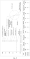
- FIG. 3 is a schematic diagram of a path graph corresponding to an address text according to an embodiment.
- each extended address forms a path in the path graph, so that there may be a plurality of directed edges between two connected nodes.
- a node corresponding to a POI may be associated with geographic coordinates corresponding to each extended address, and the geographic coordinates may be displayed near a POI node in a manner of a coordinate value, a marking point, or the like.
- directed edges corresponding to different extended addresses may be displayed in the form of different colors or different degrees of thicknesses.
- FIG. 4 is a schematic diagram of a path graph corresponding to an address text according to another embodiment. As shown in FIG. 4 , if there are a plurality of directed edges between two connected nodes, the plurality of directed edges between the two connected nodes are combined into one directed edge for displaying, and a quantity of corresponding combined directed edges is displayed near the combined directed edge in an association manner.
- the node value refers to a value that can reflect the significance of a corresponding node for accurately determining an address location of a corresponding POI, and may be represented by a proportion of a quantity of paths including the node to a total quantity of paths.
- the directed edge value refers to a value that can reflect the significance of a corresponding directed edge for accurately determining an address location of a corresponding POI, and may be represented by a proportion of a quantity of directed edges in which a current node is connected to another node to a quantity of directed edges pointed from the current node.
- the optimal path is one path obtained through the screening from a plurality of paths involved in the path graph according to the node value and the directed edge value.
- the computer device calculates a node value of each node and a directed edge value of each directed edge in the path graph, and screens the path graph to obtain a path including a target node and a target directed edge as an optimal path, the target node having a largest node value, the target directed edge having a largest directed edge value.
- the optimal path may be recorded as NodeSquence ⁇ elem_name>, which includes a plurality of nodes.
- the computer device determines an address element elem_name corresponding to each node included in the optimal path as a key address element.
- the computer device screens the address coordinate set Saddr to obtain extended addresses including all key address element(s), to obtain a key address coordinate set Maddr ⁇ point, source, address_pattern, pattern type, is _in_polygon>.
- the computer device may screen the target coordinate set to obtain extended addresses including all key address element(s), to obtain a key address coordinate set Maddr.
- the optimal path is determined by measuring the value of each node and the value of each directed edge, so that the determined optimal path is a path with a largest value, thereby ensuring the accuracy of a result of recognizing the key address element(s).
- the extended address is recorded as an intra-fence path; and the calculating a node value of each node in the path graph and a directed edge value of a directed edge between any two neighboring nodes includes: traversing each node and each directed edge in the path graph; calculating, according to a proportion of an intra-fence path including any node to all intra-fence paths, a node value of the node; calculating an out-degree of the node according to a quantity of directed edges pointed from the node; and calculating, according to a proportion of a quantity of directed edges in which the node is connected to a same node to the out-degree of the node, a directed edge value of a directed edge between the node and the same node.
- the intra-fence path refers to a path corresponding to an extended address of which geographic coordinates are located in the fence corresponding to the fence identifier. It is easy to understand that if the expanded path used for constructing the path graph is an extended address reserved after screening is performed based on the expanded fence, each path in the path graph is the intra-fence path.
- the node value of the node may be a ratio of a quantity of intra-fence paths including the node to a quantity of all intra-fence paths.
- the intra-fence path including the node refers to an intra-fence path including an address element corresponding to the node.
- the in-degree of the node refers to a quantity of directed edges pointing to the node.
- the out-degree of the node refers to a quantity of directed edges pointed from the node.
- the path graph has four directed edges pointing to "District B" and four directed edges pointed from "District B", an in-degree of the node "Town B” is 4, and an out-degree is 4.
- the directed edge value may be a ratio of a quantity of directed edges in which a current node is connected to another node to an out-degree of the current node.
- address elements corresponding to two nodes connected by a directed edge are distinguished as a preceding address element and a subsequent address element.
- the directed edge points from the preceding address element to the subsequent address element.
- a preceding address element of a directed edge pointing from "Haidian” to "Village C" is "Haidian”
- a subsequent address element is "Village C”. Therefore, the directed edge value refers to a ratio of a quantity of directed edges pointing from a preceding address element to a subsequent address element to an out-degree of the preceding address element.
- the computer device traverses and calculates a node value of each node, to obtain a node set corresponding to the path graph.
- the node set records a name of an address element and a node value that correspond to each node in the path graph.
- the node set may be recorded as Node ⁇ elem_name, node_right_rate>, elem_name being an address element corresponding to a corresponding node, node right rate being a node value of the node.
- a node set corresponding to the path graph may be Node ⁇ City A, 100%; District B, 100%; Village C, 50%; Street D, 25%; Road F, 25%; Store E, 100%>.
- the computer device traverses and calculates an in-degree and an out-degree of each node, to obtain an out/in-degree set corresponding to the path graph.
- the out/in-degree set may be recorded as Degree ⁇ elem_name, in_count, out_count>, in_count being an in-degree of a node elem_name, out count being an out-degree of the node elem_name.
- an out/in-degree set corresponding to the path graph may be Degree ⁇ City A, 0, 4; District B, 4, 4; Village C, 2, 2; Street D, 1, 2; Road F, 1, 1; Store E, 4, 0>.
- the computer device traverses and calculates a directed edge value of each directed edge, to obtain a directed edge set corresponding to the path graph.
- the directed edge refers to a directed edge between two neighboring nodes.
- the directed edge set records a name of a preceding address element, a name of a subsequent address element, and a directed edge value that correspond to each directed edge in the path graph.
- the directed edge set may be recorded as Edge ⁇ in_elem, out_elem, edge_right_rate>, in_elem being a name of a preceding address element, out_elem being a name of a subsequent address element, edge right rate being a directed edge value of a directed edge connecting the preceding address element and the subsequent address element. For example, as shown in FIG. 3 or FIG.
- a directed edge set corresponding to the path graph may be Edge ⁇ City A, District B, 100%; District B, Village C, 50%; District B, Street D, 25%; District B, Road F, 25%; Village C, Store E, 50%; Village C, Street D, 50%; Street D, Store E, 100%; Road F, Store E, 100%>.
- the node values of the plurality of nodes and the directed edge values of the plurality of directed edges may be determined for the address text in a targeted manner, and the specific problem is specifically analyzed, so that the determined node values and the determined directed edge values can accurately reflect the significance of each node and each directed edge for determining the optimal path, thereby improving the accuracy of the coordinate processing.
- the determining an optimal path according to the node value and the directed edge value includes: determining a parent node of each node according to the node value and the directed edge value; marking a node having a zero in-degree as a head node, and marking a node having a zero out-degree as a tail node; determining the tail node as a current level node of the optimal path; and iterating a parent node of the current level node as the current level node until the head node, to obtain the optimal path including a plurality of level nodes
- the determining a target path according to each node value and each directed edge value includes: determining a parent node of each node according to each node value and each directed edge value; calculating an in-degree of each node according to a quantity of directed edges pointing to each node; marking a node having a zero in-degree as a head node, and marking a node having a zero out-degree as a tail node; determining the tail node as a first level node of the target path; and determining a parent node of the first level node as a second level node of the target path, and determining a parent node of the second level node as a third level node of the target path until a determined level node is the head node, to obtain the target path including a plurality of level nodes.
- the head node refers to a node having a zero in-degree
- the tail node refers to a node having a zero out-degree.
- "City A” in the path graph is a head node
- "Store E” is a tail node.
- a preceding node refers to a preceding address element to which a node as a subsequent address element is connected by a directed edge.
- One node may have a plurality of preceding nodes. For example, as shown in FIG. 3 or FIG. 4 , in the path graph, preceding nodes corresponding to "Street D" are "District B" and "Village C".
- a parent node of a current node is a preceding node corresponding to the current node. It is easy to understand that the head node does not have a parent node.
- the computer device determines a parent node of each node other than a head node in the path graph according to a Dijkstra algorithm, to obtain a parent node set.
- the parent node set may be recorded as NodeF(elem_name, father_elem), father_elem being a parent node of the node elem_name.
- each path includes a plurality of address elements arranged in sequence.
- the levels of different address elements in the path may be distinguished according to the sequence, and a higher rank indicates that a corresponding level is higher.
- the tail node is used as a node of the lowest level in the optimal path.
- the computer device performs reverse traversal on the path graph by using the tail node as a current level node, traces a parent node of the current level node, continuously traces, by using the parent node as a current level node, a parent node of the current level node until the parent node of the current level node is the head node, and forms the optimal path based on a plurality of level nodes obtained through the tracing.
- the parent node of each node is determined according to the value of each node and the value of each directed edge, and a path with a largest value may be determined by backward tracing of the parent node.
- the determining a parent node of each node according to the node value and the directed edge value includes: determining another node of which a directed edge points to a current node as a preceding node of the current node; and calculating, when there are a plurality of preceding nodes, a link value of each preceding node relative to the current node according to node values of the preceding nodes and a directed edge value of a directed edge used for connecting the current node and a preceding node, and determining a preceding node with a largest link value as a parent node of the current node.
- the determining a parent node of each node according to each node value and each directed edge value includes: determining another node of which a directed edge points to a current node as a preceding node of the current node; and calculating, when there are a plurality of preceding nodes, a link value of each preceding node relative to the current node according to a node value of each preceding node and a directed edge value of a directed edge used for connecting the current node and a corresponding preceding node, and determining a preceding node with a largest link value as a parent node of the current node.
- the link value is a value that can reflect the significance of a local path formed by connecting directed edges for determining the optimal path, and may be represented by a product of a node value node right rate of a preceding node and a directed edge value edge right rate of a directed edge used for connecting a current node and the preceding node.
- the link value is recorded as trans_right_rate.
- the computer calculates a link value of each preceding node relative to a current node, and determines a preceding node with a largest link value as a parent node of the current node. If there are a plurality of preceding nodes with the largest link value, one preceding node is selected as a parent node according to a preset rule. For example, a preceding node with a largest node value is selected as a parent node, a preceding node with a largest directed edge value is selected as a parent node, or a preceding node is randomly selected as a parent node.
- a link value of each preceding node connected to a current node is measured according to a value of the node and a value of a directed edge, and a preceding node with a largest link value is selected as a parent node, so that a plurality of local paths with large values may be determined, and then the optimal path with the largest value may be determined according to the values of the local paths.
- the fence address-based coordinate data processing method further includes: recognizing a POI text in the address text; combining, when there are a plurality of POI texts, the plurality of POI texts, to obtain a combined POI text; querying an alias POI text associated with the POI text; performing synonymous replacement on a text word included in the POI text, to obtain a synonymous POI text; and determining the combined POI text, the alias POI text, and the synonymous POI text as extended POI texts corresponding to the POI text.
- the POI text in the address text is recognized; and at least one of the combined POI text, the alias POI text, or the synonymous POI text is determined as the extended POI text corresponding to the POI text.
- the combined POI text is obtained by combining the plurality POI texts
- the alias POI text is obtained by querying an alias POI text associated with the POI text
- the synonymous POI text is obtained by performing synonymous replacement on the text word included in the POI text.
- the POI text refers to a POI entity in the address text. There may be a plurality of POI texts in the same address text. For example, there are two POI texts “Building H” and "Store I” in an address text "Opposite Store I, Building H, No. 66, North Fourth Ring, District B, City A”.
- An alias POI is another name of the same POI based on different descriptions of the POI text, and may be an official legal normalized name of the POI, or a name other than the normalized name.
- the computer device further stores different names of a plurality of POI entities in the storage apparatus.
- an alias POI corresponding to the POI text "Building H" may be "Mall J", "Mansion K", or the like.
- a synonymous POI is a new POI text obtained by performing synonymous replacement on one or more finer granularity words in the POI text.
- a finer granularity word corresponding to a POI text "Star Small School” includes two elements of “Star” and “Small School”.
- "Small School” has synonyms "School” and “Primary School”, so that synonymous POIs "Star Primary School” and "Star School” may be obtained through the extending.
- the computer device performs semantic extension on a POI text from a plurality of dimensions. If there are a plurality of POI texts in the address text, the computer device combines the POI texts in a continuous bigram manner, that is, combines two neighboring POI texts according to an order in which the POI texts appear in the address text, to obtain a combined POI. For example, if three POI texts A, B, and C appear in an address text in sequence, AB obtained by combining A and B and BC obtained by combining B and C are respectively used as a combined POI text.
- the computer device queries the storage apparatus for another name corresponding to the POI text, and uses the queried another name as an alias POI text.
- the computer device splits the POI text into a plurality of words with finer granularity, performs synonymous replacement on one or more words, and combines the replaced words, to obtain one or more synonymous POI texts.
- the computer device determines the combined POI text, the alias POI text, and the synonymous POI text as extended POI texts corresponding to the POI text, and constructs a POI entity set based on the POI text and the extended POI text.
- the POI entity set may be recorded to as Epoi ⁇ input_poi_list>, input_poi_list being a list of POI entities generated by the address text and the combined POI text, the alias POI text, and the synonymous POI text that are obtained through the extending.
- the POI text is extended from a plurality of dimensions, a plurality of POIs that is actually and possibly intended to positioned in the address text may be predicted, and a problem of irregular description of the POI text or single information may be overcome.
- Synonymous extension is performed while combined extension and alias extension are performed, omission of predicting a possible POI due to the word segmentation error of the address text may be avoided, and a description coverage of the POI is improved, thereby improving the accuracy of subsequent coordinate processing based on an extended POI text.
- the fence address-based coordinate data processing method further includes: searching for an associated address corresponding to each extended POI text and geographic coordinates; and screening corresponding geographic coordinates depending on whether an associated address corresponding to each of geographic coordinates includes a key address element and whether the geographic coordinates are located in the target fence corresponding to the fence identifier.
- an associated address corresponding to each extended POI text and geographic coordinates corresponding to each associated address are searched for; and the geographic coordinates are screened depending on whether an associated address corresponding to any of geographic coordinates corresponding to each associated address includes a key address element and whether the geographic coordinates are located in the target fence corresponding to the fence identifier.
- the associated address refers to an address text that is related to an inputted extended POI and returned based on a coordinate retrieval service.
- the coordinate retrieval service is used for returning POI information conforming to position and name information according to inputted geographic location information constrained to a dimension such as a fixed county. A case in which no result is retrieved also needs to be recorded. In this case, a point in an S set is empty.
- An extended POI may correspond to a plurality of associated addresses. Each associated address has geographic coordinates.
- the associated address includes a plurality of address elements, and one or more address elements are associated POIs that are the same or similar to the inputted extended POIs.
- the coordinate retrieval service ranks retrieval results obtained through the retrieval according to a matching degree with an inputted retrieval condition.
- a preset quantity of associated addresses that rank in the top may be selected, for example, first 10 associated addresses are selected to participate in subsequent coordinate processing.
- the computer device uses each extended POI input_poi as an input, and searches for a retrieval result corresponding to each input_poi based on the coordinate retrieval service.
- the retrieval result includes an associated address output_poi corresponding to the extended POI input_poi and geographic coordinates point corresponding to each associated address.
- the extended POI and the corresponding retrieval result may form a POI coordinate set Spoi ⁇ point, input_poi, output_poi>.
- the computer device screens output_poi depending on whether each associated address output_poi in the Spoi includes all key address elements, to obtain a key POI set Mpoi ⁇ point, input_poi, output_poi>.
- the computer device performs fence constraint on each point of the Mpoi based on a fence corresponding to the fence identifier, that is, selects points in the Mpoi that are located in the fence corresponding to the fence identifier, to obtain a valid POI set Rpoi ⁇ point, input_poi, output_poi>.
- the computer device performs fence constraint again on each point in the key address coordinate set Maddr obtained by screening and recognizing the key address element(s) based on the optimal path, that is, filters each point in the Maddr that is not in the fence corresponding to the fence identifier, to obtain a valid address coordinate set Raddr ⁇ point, source, address_pattern, pattern_type>.
- two times of fence constraint are performed on the geographic coordinates point corresponding to the extended address, one time of fence constraint is performed on points in the Saddr based on the expanded fence, to obtain the S2addr; and after coordinate screening is performed on points in the Saddr or the S2addr depending on whether the key address element(s) are included to obtain the Maddr, the other time of fence constraint is performed on points in the Maddr based on an unexpanded fence, to obtain the Raddr.
- the extended POIs used for coordinate processing are screened according to the fence constraint and presence or absence of the key address element(s), only the extended POIs meeting a screening condition can participate in coordinate processing, which not only helps to improve the accuracy of the processing result, but also improves the efficiency of coordinate processing because a data volume of the extended POIs participating in coordinate processing is accurately limited.
- the determining, according to a clustering feature of the geographic coordinates, geographic coordinates obtained through the screening as processed coordinates includes: calculating, when there is no extended POI that meets a screening condition, a clustering density and a clustering distance of geographic coordinates corresponding to each extended address obtained through the screening; determining a target function for maximizing the clustering densities and the clustering distances that correspond to the geographic coordinates; and determining, by performing screening, geographic coordinates with a largest value of a corresponding target function obtained through the screening as the processed coordinates.
- a clustering density and a clustering distance of geographic coordinates corresponding to each extended address obtained through the screening are calculated; a target function for maximizing the clustering densities and the clustering distances of the geographic coordinates is determined; and a value of the target function of the geographic coordinates corresponding to each extended address obtained through the screening is obtained, and geographic coordinates with a largest value of the target function are determined as the processed coordinates.
- the fence address-based coordinate data processing method is a method for extracting geographic coordinates of an address text based on a fence address, the processed coordinates are geographic coordinates obtained after performing coordinate extraction on the address text; and if the fence address-based coordinate data processing method is a method for performing error correction on an address text based on a fence address, the processed coordinates are corrected geographic coordinates corresponding to the address text.
- the obtaining a value of the target function of the geographic coordinates corresponding to each extended address obtained through the screening, and determining geographic coordinates with a largest value of the target function as the processed coordinates may include: obtaining the value of the target function of the geographic coordinates corresponding to each extended address obtained through the screening, and determining the geographic coordinates with the largest value of the target function as corrected coordinates.
- the screening condition of the extended POI includes that the associated address corresponding to the extended POI includes all key address element(s), and the geographic coordinates corresponding to the associated address are located in the target fence corresponding to the fence identifier.
- the clustering density is a local density of the geographic coordinates. A higher local density of the geographic coordinates indicates more coordinate points around a coordinate point corresponding to the geographic coordinates.
- the clustering distance refers to a distance between a coordinate point corresponding to geographic coordinates and the closest coordinate point with a higher clustering density. A greater clustering distance indicates a greater "distance" between the geographic coordinates and another geographic coordinates with a higher clustering density.
- ⁇ i and ⁇ i may be defined for any geographic coordinates point i (1 ⁇ i ⁇ N) in the geographic coordinate set Rpoint.
- the clustering density ⁇ i includes two calculation methods of Cut-off kernel and Gaussian kernel.
- ⁇ i ⁇ j ⁇ R p o int ⁇ i ⁇ d ij ⁇ d c
- a parameter d ij dist point i , point j 0
- x ⁇ 0 represents a distance between geographic coordinates point i and geographic coordinates point j
- a parameter dc>0 is a cut-off distance, which may be preset.
- ⁇ i represents a quantity of geographic coordinates point of which a distance to the point i is less than d c in the Rpoint.
- a corresponding clustering density ⁇ i and a corresponding clustering distance ⁇ i may be calculated for each of geographic coordinates points in the Ppoint.
- the computer device may calculate a value (which is referred to as "hotness" below) of the target function according to a clustering density and a clustering distance that correspond to each point in the Rpoint, to obtain a coordinate hotness set Rcluster ⁇ point, hot_value>.
- the hot value is hotness of the geographic coordinates point.
- the hotness represents a Gaussian density distribution value of geographic coordinates, and greater hotness indicates a greater probability that corresponding geographic coordinates are used as a cluster center point and indicates that more aggregation is achieved.
- the processed coordinates are selected in the Raddr.
- the computer device sorts a plurality of points in descending order according to the hotness, selects geographic coordinates point with largest hotness, where the selected geographic coordinates may be considered as geographic coordinates with a relatively large clustering density and a relatively large clustering distance, and determines the geographic coordinates obtained through the screening as processed coordinates corresponding to the address text.
- the geographic coordinates corresponding to the extended addresses are screened to obtain geographic coordinates with the highest aggregation as the processed coordinates, thereby ensuring the accuracy of the processing result.
- the screening the geographic coordinates corresponding to the extended addresses to obtain geographic coordinates with the highest aggregation as the processed coordinates may include: when there is no extended POI that meets the screening condition, screening the geographic coordinates corresponding to the extended addresses to obtain the geographic coordinates with the highest aggregation as the corrected coordinates, thereby ensuring the accuracy of the error correction result.
- the determining, according to a clustering feature of the geographic coordinates, geographic coordinates obtained through the screening as processed coordinates includes: calculating, when there is an extended POI that meets the screening condition, a text similarity between the extended POI and an associated POI included in a corresponding associated address; determining whether there is an associated address of which a text similarity exceeds a first threshold; recognizing, when the text similarity of the associated address exceeds the first threshold, whether identical geographic coordinates exist in the associated address and the extended address obtained through the screening, the identical geographic coordinates being recorded as intersection coordinates; and determining, when there are a plurality of intersection coordinates according to clustering features of the intersection coordinates, intersection coordinates as the processed coordinates.
- the associated address corresponding to each of the geographic coordinates obtained through the screening is obtained, and a text similarity between the extended POI text and an associated POI text included in each associated address corresponding to the extended POI text is calculated; it is determined whether there is an associated address of which a text similarity exceeds a first threshold; when a text similarity of any associated address exceeds the first threshold, identical geographic coordinates in the associated address and the extended address obtained through the screening are recognized, and the identical geographic coordinates are recorded as intersection coordinates; and when there are a plurality of intersection coordinates, intersection coordinates obtained through the screening are determined as the processed coordinates according to a clustering feature of each of the intersection coordinates.
- the determining, when there are a plurality of intersection coordinates, intersection coordinates obtained through the screening as the processed coordinates according to a clustering feature of each of the intersection coordinates may include: determining, when there are the plurality of intersection coordinates according to the clustering feature of each of the intersection coordinates, the intersection coordinates obtained through the screening as the corrected coordinates.
- the text similarity is a value used for representing a similarity between a name of an extended POI and a name of an associated POI, and may be calculated according to an algorithm such as a cosine similarity, a simple common word, an edit distance, a Hamming distance, or a Euclidean distance.
- the intersection coordinates refer to the identical geographic coordinates point in the target POI set and the valid address set Raddr.
- the target POI set is a POI set obtained by screening the valid POI set Rpoi to obtain an associated address of which a text similarity with a corresponding extended POI exceeds the first threshold.
- the first threshold may be freely set according to requirements, for example, 0.5.
- the target POI set may be recorded as Rright_poi ⁇ point, input_poi, output_poi, similar_score>, similar_score being a text similarity between input_poi and output_poi.
- the computer device calculates a text similarity between each extended POI and an associated POI included in each associated address corresponding to the extended POI, and recognizes whether there is an associated POI of which a text similarity exceeds a first threshold. If there is no associated POI of which a text similarity exceeds the first threshold, the computer device returns processing failure prompt information to a terminal reporting the address text.
- the computer device when there is no associated POI in which a text similarity exceeds the first threshold, the computer device generates a processing task according to the address text and the fence identifier, and publishes the processing task to a geocoding operation platform (recorded as a GEO operation platform).
- a task terminal runs a GEO operation client. The operator may access the GEO operation platform by using the GEO operation client on the task terminal to process the processing task.
- the GEO operation client displays a processing task management page.
- the processing task management page displays task identifiers of a plurality of processing tasks and attribute information such as a corresponding address text, a processing result, and a processing time.
- the task terminal jumps, when obtaining a trigger operation of a user for a particular task identifier, from the processing task management page to a processing page of a corresponding processing task.
- the processing page of the processing task includes a processing task list region and a map display region.
- the processing task list region displays a plurality of processing tasks and corresponding attribute information in the form of a list.
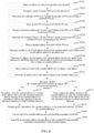
- FIG. 5 is a schematic diagram of an interface of a map display region according to an embodiment. As shown in FIG. 5 , the operator selects a processing task that needs to be currently processed from the plurality of processing tasks displayed by the processing task list region, and the map display region displays a digital map and displays a fence identifier and a fence contour that correspond to the selected processing task in the digital map.
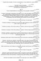
- FIG. 6 is a schematic diagram of an interface of a peripheral retrieval auxiliary region according to an embodiment.
- the operator may enter a retrieval keyword in an auxiliary positioning box displayed in the map display region, and the peripheral retrieval auxiliary region displays a retrieval result based on the retrieval keyword. For example, a retrieval keyword "New Mansion" is entered, and four related retrieval results meeting the name appear on the right side. The operator may assist in determining based on these related retrieval results for submission of an operation result.
- the GEO operation platform may further count whether the address text has a coordinate error, an error correction mode, or the like, and display a statistical result.
- FIG. 7 is a schematic diagram of an interface of an error correction task statistical result page according to an embodiment.
- the computer device screens points in the valid POI set Rpoi depending on whether the text similarity exceeds the first threshold, to obtain the target POI set Rright_poi.
- the computer device recognizes whether there are intersection coordinates between the Rright_poi and the Raddr. If there are intersection coordinates, the computer device directly uses the intersection coordinates as the processed coordinates corresponding to the address text.
- the computer device calculates a clustering density and a clustering distance of each of the intersection coordinates, determines a target function for maximizing the clustering densities and the clustering distances that correspond to the intersection coordinates, and determines, by performing screening, geographic coordinates with a largest value of a corresponding target function as the processed coordinates.
- the determining a target function for maximizing the clustering densities and the clustering distances that correspond to the intersection coordinates, and determining, by performing screening, geographic coordinates with a largest value of a corresponding target function as the processed coordinates refers to: determining the target function for maximizing the clustering densities and the clustering distances that correspond to the intersection coordinates, determining a value of a target function corresponding to the intersection coordinates according to the target function, and determining intersection coordinates with the largest value of the target function as the processed coordinates.
- the clustering feature and the text similarity are comprehensively considered, a multi-level coordinate screening policy is formed, and the extended POI and the geographic coordinates of the extended address are screened based on the multi-level coordinate screening policy, thereby improving the accuracy of the processing result.
- the fence address-based coordinate data processing method further includes: traversing, when there are no intersection coordinates, geographic coordinates of a plurality of associated addresses obtained through the screening in descending order of text similarities; calculating a coordinate distance between geographic coordinates of a current associated address and the geographic coordinates corresponding to each extended address obtained through the screening; determining, when the coordinate distance is less than a second threshold, the geographic coordinates of the current associated address as the processed coordinates; and determining, when there are still no geographic coordinates that cause the coordinate distance is less than the second threshold after all the associated addresses have been traversed, geographic coordinates of an associated address with a highest text similarity as the processed coordinates.
- geographic coordinates of a plurality of associated addresses obtained through the screening are traversed in descending order of text similarities; a coordinate distance between geographic coordinates of each of the plurality of associated addresses obtained through the screening and the geographic coordinates corresponding to each extended address obtained through the screening is calculated; when any coordinate distance obtained is less than a second threshold, geographic coordinates of an associated address corresponding to the coordinate distance are determined as the processed coordinates; and when there are still no geographic coordinates that cause the coordinate distance to be less than the second threshold after all the associated addresses have been traversed, geographic coordinates of an associated address with a highest text similarity are determined as the processed coordinates.
- the coordinate distance refers to a distance between coordinate points corresponding to two geographic coordinates on the digital map or a corresponding actual spatial distance.
- the computer device traverses points in the Rright_poi ⁇ point, input_poi, output_poi, similar_score> according to the text similarity similar_score in descending order, calculates a coordinate distance between geographic coordinates CurPointright_poi corresponding to a current associated address and each point in the Raddr, and determines whether there is a point of which a coordinate distance is less than a second threshold. If there is a point of which a coordinate distance is less than the second threshold, the computer device determines the geographic coordinates CurPointright_poi corresponding to the coordinate distance as the processed coordinates corresponding to the address text.
- the computer device determines geographic coordinates of an associated address with a highest text similarity in the Rright_poi as the processed coordinates.
- the computer device after determining the processed coordinates corresponding to the address text, stores the address text and the processed coordinates to a preset coordinate whitelist in an association manner. After subsequently receiving an address text reported by the terminal, the computer device may preferentially query whether a similar address text is stored in the coordinate whitelist, directly uses, if there is a similar address text, processed coordinates of the similar address text as coordinates of a current address text and performs coordinate processing on the processed coordinates. Only when no address text is queried in the coordinate whitelist, the address text needs to be processed and calculated according to the foregoing logic, thereby saving calculation resources of the computer device and improving the coordinate processing efficiency.
- whether geographic coordinates selected based on the clustering feature and the text similarity can be used as the final processed coordinates is determined with the aid of a distance between geographic coordinates, and the geographic coordinates are strictly screened layer by layer, thereby improving the accuracy of a processing result.
- FIG. 8 , FIG. 9 , and FIG. 10 collectively show a schematic flowchart of a fence address-based coordinate data processing method according to an embodiment.
- the fence address-based coordinate data processing method includes steps of obtaining an address text S5102, POI extension S5202 to S5210, address extension S5302 to S5318, and coordinate conversion S5402 to S5404, as follows:
- the fence address-based coordinate data processing method further includes steps of first fence constraint S5502 to S5210506 and key address element detection S5602 to S5624, as follows:
- the fence address-based coordinate data processing method includes steps of screening coordinates based on a key element and second fence constraint S5702, performing extraction by using a clustering feature, comparing text similarities, and calculating a coordinate distance to determine processed coordinates S5802 to S5824, as follows:
- a plurality of extended addresses may be obtained, and the obtained extended addresses may be respectively converted into corresponding geographic coordinates, thereby obtaining a plurality of possible geographic coordinates.
- region constraint is performed based on a target fence, the geographic coordinates are screened depending on whether the recognized key address element(s) are included, and some invalid geographic coordinates may be filtered.
- Final geographic coordinates are determined based on a clustering feature in the geographic coordinates obtained through the screening and filtering, and the accuracy of the processing result can be improved based on the multi-level screening and a high aggregation requirement.
- the corresponding processed coordinates may be quickly fed back by only providing the address text, the manual processing costs are reduced, and the timeliness of processing a coordinate data processing task can be improved.
- FIG. 11 is a schematic principle diagram of a fence address-based coordinate data processing method according to an embodiment.
- the principle of processing an obtained address text by the computer device is to perform coordinate screening after performing coordinate expansion on the address text.
- the computer device after performing address splitting and POI recognition on an address text, the computer device performs address extension and POI extension, converts extended addresses and extended POIs into corresponding geographic coordinates respectively, screens, after performing first fence constraint on the geographic coordinates of the extended addresses, the geographic coordinates corresponding to the extended addresses and the extended POIs depending on whether the recognized key address element(s) are included, and performs second fence constraint on the geographic coordinates obtained through the screening.
- the geographic coordinates after being subject to the second fence constraint are further screened according to information about a plurality of dimensions such as a clustering feature, a text similarity, and a coordinate distance, to obtain final processed coordinates.
- the computer device launches the processed coordinates, that is, writes the processed coordinates into a coordinate whitelist. If processing fails based on the fence address-based coordinate data processing method, the process is performed manually.
- the coverage of resolving a large quantity of fed back error coordinate events and the timeliness may be improved, a large amount of manpower is saved, an effective automatic correction capability is provided, and the objective of repairing data online in a short time is achieved.
- a technology such as address segmentation, POI entity and key address element recognition, re-combination of standard addresses, extension /address extension, or POI entity retrieval, a valid coordinate set is obtained, multi-level screening is performed on coordinates by using fence constraint, coordinate aggregation, text similarity, or the like, and the coordinate processing efficiency and accuracy are improved while the complexity of secondary query based on a model is ingeniously avoided.
- FIG. 2 and FIG. 5 are schematic flowcharts of a fence address-based coordinate data processing method according to an embodiment. It is to be understood that, although each step of the flowcharts in FIG. 2 and FIG. 5 is displayed sequentially according to arrows, the steps are not necessarily performed according to an order indicated by arrows. Unless clearly specified in this specification, there is no strict sequence limitation on the execution of the steps, and the steps may be performed in another sequence. Furthermore, at least some steps in FIG. 2 and FIG. 5 may include a plurality of sub-steps or a plurality of stages. The sub-steps or stages are not necessarily performed at the same moment, and may be performed at different moments. The sub-steps or stages are not necessarily performed in order, and may be performed in turn or alternately with other steps or at least some of sub-steps or stages of other steps.
- a fence address-based coordinate data processing apparatus 700 including an address obtaining module 702, a coordinate extension module 704, and a coordinate screening module 706.
- the address obtaining module 702 is configured to obtain an address text and a corresponding fence identifier.
- the coordinate extension module 704 is configured to perform semantic extension on the address text to obtain a plurality of extended addresses; and convert each of the extended addresses into corresponding geographic coordinates.
- the coordinate screening module 706 is configured to recognize key address element(s) in the plurality of extended addresses; screen the geographic coordinates depending on whether an extended address corresponding to a geographic coordinate includes the recognized key address element and whether the geographic coordinate is located in a target fence corresponding to the fence identifier; and determine, according to a clustering feature of each of the screened geographic coordinates, one of the screened geographic coordinates as a processed coordinate.
- the coordinate extension module 704 includes an address extension module 7042, configured to obtain a standard address associated with a POI text included in the address text; determine an address role of each address element in the standard address and an address role of each address element in the address text; and determine an address role that appears in the standard address but does not appear in the address text, and fill the address text with the address element corresponding to the address role, to obtain an extended address.
- an address extension module 7042 configured to obtain a standard address associated with a POI text included in the address text; determine an address role of each address element in the standard address and an address role of each address element in the address text; and determine an address role that appears in the standard address but does not appear in the address text, and fill the address text with the address element corresponding to the address role, to obtain an extended address.
- the address extension module 7042 is further configured to filter invalid text words in the address text, to obtain a valid address; determine the address role of each address element in the address text; recognize whether the address text includes all address roles in a preset role annotation sequence; recombine, when the address text includes all the address roles in the role annotation sequence, address elements of the address text according to address roles appearing in the role annotation sequence, to obtain combined addresses, and deduplicate the valid address and the combined addresses, to obtain the plurality of extended addresses; freely combine the address elements in the address text when the address text does not include all the address roles in the role annotation sequence, to obtain enumerated addresses; and deduplicate the valid address and the enumerated addresses, to obtain the plurality of extended addresses.
- the fence address-based coordinate data processing apparatus 700 further includes an extended fence constraint module 708, configured to expand a fence boundary of a fence corresponding to the fence identifier by a preset distance; determine whether geographic coordinates corresponding to the plurality of extended addresses are located in the expanded fence; screen, when any geographic coordinates are not located in the expanded fence, the extended address corresponding to the geographic coordinates.
- the coordinate screening module 706 is further configured to recognize the key address element(s) in the extended addresses obtained through the screening.
- the coordinate screening module 706 includes a key element recognition module 7062, configured to construct a path graph corresponding to the address text by using each address element included in the plurality of extended addresses as a node and using a neighborhood relationship between different address elements in a same extended address as a directed edge; calculate a node value of each node in the path graph and a directed edge value of a directed edge between any two neighboring nodes; determine a target path according to each node value and each directed edge value; and determine each address element included in the target path as the key address element.
- a key element recognition module 7062 configured to construct a path graph corresponding to the address text by using each address element included in the plurality of extended addresses as a node and using a neighborhood relationship between different address elements in a same extended address as a directed edge; calculate a node value of each node in the path graph and a directed edge value of a directed edge between any two neighboring nodes; determine a target path according to each node value and each directed edge value; and determine each address element included
- the extended address is recorded as an intra-fence path; and the key element recognition module 7062 is further configured to traverse each node and each directed edge in the path graph; calculate, according to a proportion of an intra-fence path including any node to all intra-fence paths, a node value of the node; calculate an out-degree of the node according to a quantity of directed edges pointed from the node; and calculate, according to a proportion of a quantity of directed edges in which the node is connected to a same node to the out-degree of the node, a directed edge value of a directed edge between the node and the same node.
- the key element recognition module 7062 is further configured to determine a parent node of each node according to each node value and each directed edge value; calculate an in-degree of each node according to a quantity of directed edges pointing to each node; determine a tail node as a first level node of the target path; and determine a parent node of the first level node as a second level node of the target path, and determine a parent node of the second level node as a third level node of the target path until a determined level node is a head node, to obtain the target path including a plurality of level nodes.
- the key element recognition module 7062 is further configured to determine another node of which a directed edge points to a current node as a preceding node of the current node; and calculate, when there are a plurality of preceding nodes, a link value of each preceding node relative to the current node according to a node value of each preceding node and a directed edge value of a directed edge used for connecting the current node and a corresponding preceding node, and determine a preceding node with a largest link value as a parent node of the current node.
- the coordinate extension module 704 further includes a POI extension module 7044, configured to recognize a POI text in the address text; and determine at least one of a combined POI text, an alias POI text, or a synonymous POI text as an extended POI text corresponding to the POI text, where when there are a plurality of POI texts, the combined POI text is obtained by combining the plurality POI texts, the alias POI text is obtained by querying an alias POI text associated with the POI text, and the synonymous POI text is obtained by performing synonymous replacement on a text word included in the POI text.
- a POI extension module 7044 configured to recognize a POI text in the address text; and determine at least one of a combined POI text, an alias POI text, or a synonymous POI text as an extended POI text corresponding to the POI text, where when there are a plurality of POI texts, the combined POI text is obtained by combining the plurality POI texts, the alias POI text
- the POI extension module 7044 is further configured to search for an associated address corresponding to each extended POI text and geographic coordinates corresponding to each associated address; and screen the geographic coordinates depending on whether an associated address corresponding to any of geographic coordinates obtained through the searching includes a key address element and whether the geographic coordinates are located in the target fence corresponding to the fence identifier.
- the coordinate screening module 706 further includes a clustering feature extraction module 7064, configured to calculate, when the geographic coordinates corresponding to each associated address are screened out, a clustering density and a clustering distance of geographic coordinates corresponding to each extended address obtained through the screening; determine a target function for maximizing the clustering densities and the clustering distances that correspond to the geographic coordinates; and obtain a value of the target function of the geographic coordinates corresponding to each extended address obtained through the screening, and determine geographic coordinates with a largest value of the target function as the processed coordinates.
- a clustering feature extraction module 7064 configured to calculate, when the geographic coordinates corresponding to each associated address are screened out, a clustering density and a clustering distance of geographic coordinates corresponding to each extended address obtained through the screening; determine a target function for maximizing the clustering densities and the clustering distances that correspond to the geographic coordinates; and obtain a value of the target function of the geographic coordinates corresponding to each extended address obtained through the screening, and determine geographic coordinates with
- the coordinate screening module 706 further includes a text similarity comparison module 7066 and an intersection coordinate recognition module 7068.
- the text similarity comparison module 7066 is configured to obtain the associated address corresponding to each of the geographic coordinates obtained through the screening, and calculate a text similarity between the extended POI text and an associated POI text included in each associated address corresponding to the extended POI text; and determine whether there is an associated address of which a text similarity exceeds a first threshold.
- intersection coordinate recognition module 7068 is configured to recognize, when a text similarity of any associated address exceeds the first threshold, identical geographic coordinates in the associated address and the extended address obtained through the screening are recognized, the identical geographic coordinates being recorded as intersection coordinates; and determine, when there are a plurality of intersection coordinates, intersection coordinates obtained through the screening as the processed coordinates according to a clustering feature of each of the intersection coordinates.
- intersection coordinate recognition module 7068 is further configured to traverse, when there are no intersection coordinates, geographic coordinates of a plurality of associated addresses obtained through the screening in descending order of text similarities; calculate a coordinate distance between geographic coordinates of each of the plurality of associated addresses obtained through the screening and the geographic coordinates corresponding to each extended address obtained through the screening; determine, when any coordinate distance obtained is less than a second threshold, geographic coordinates of an associated address corresponding to the coordinate distance as the processed coordinates; and determine, when there are still no geographic coordinates that cause the coordinate distance to be less than the second threshold after all the associated addresses have been traversed, geographic coordinates of an associated address with a highest text similarity as the processed coordinates.
- a plurality of extended addresses may be obtained, and the obtained extended addresses may be respectively converted into corresponding geographic coordinates, thereby obtaining a plurality of possible geographic coordinates.
- region constraint is performed based on a target fence, the geographic coordinates are screened depending on whether the recognized key address element(s) are included, and some invalid geographic coordinates may be filtered.
- Final geographic coordinates that may be used as a processing result are determined based on a clustering feature in the geographic coordinates obtained through the screening and filtering, and the accuracy of the processing result can be improved based on the multi-level screening and a high aggregation requirement.
- the corresponding processed coordinates may be quickly fed back by only providing the address text, the manual processing costs are reduced, and the timeliness of processing a coordinate processing task can be improved.
- FIG. 14 is a diagram of an internal structure of a computer device according to an embodiment.
- the computer device may be the terminal 110 in FIG. 1 .
- the computer device includes a processor, a memory, a network interface, an input apparatus, and a display screen that are connected by a system bus.
- the memory includes a non-volatile storage medium and an internal memory.
- the non-volatile storage medium of the computer device stores an operating system, and may further store a computer program, the computer program, when executed by the processor, causing the processor to perform the fence address-based coordinate data processing method.
- the internal memory may also store a computer program.
- the computer program, when executed by the processor may cause the processor to perform the fence address-based coordinate data processing method.
- the display screen of the computer device may be a liquid crystal display screen or an e-ink display screen.
- the input apparatus of the computer device may be a touch layer covering the display screen, or a button, a trackball, or a touchpad disposed on a housing of the computer device, or an external keyboard, touchpad, mouse, or the like.
- FIG. 15 is a diagram of an internal structure of a computer device according to an embodiment.
- the computer device may be the server 120 in FIG. 1 .
- the computer device includes a processor, a memory, a network interface, and a database that are connected by using a system bus.
- the processor of the computer device is configured to provide computing and control capabilities.
- the memory of the computer device includes a non-volatile storage medium and an internal memory.
- the non-volatile storage medium stores an operating system, a computer program, and a database.
- the internal memory provides an environment for running of the operating system and the computer program in the non-volatile storage medium.
- the database of the computer device is configured to store standard addresses of a plurality of POI entities, a coordinate whitelist, or the like.
- the network interface of the computer device is configured to communicate with an external terminal through a network connection.
- the computer program is executed by the processor to implement the fence address-based coordinate data processing method.
- FIG. 14 and FIG. 15 is only a block diagram of a partial structure related to the solution of the present disclosure, and does not limit the computer device to which the solution of the present disclosure is applied.
- the computer device may include more or fewer components than those shown in the figure, or some components may be combined, or different component deployment may be used.
- the fence address-based coordinate data processing apparatus may be implemented in a form of a computer program, and the computer program may run on the computer device shown in FIG. 14 and FIG. 15 .
- the memory of the computer device may store program modules such as the address obtaining module, the coordinate extension module, and the coordinate screening module shown in FIG. 12 forming the fence address-based coordinate data processing apparatus.
- the computer program formed by the program modules causes the processor to perform the steps of the fence address-based coordinate data processing method described in the embodiments of the present disclosure in this specification.
- the computer device shown in FIG. 14 and FIG. 15 may perform step S202 by using the address obtaining module in the fence address-based coordinate data processing apparatus shown in FIG. 12 .
- the computer device may perform step S204 to step S206 by using the coordinate extension module.
- the computer device may perform step S208 to step S212 by using the coordinate screening module.
- a computer device including a processor and a memory.
- the memory stores a computer program, the computer program, when executed by the processor, causing the processor to perform the steps of the fence address-based coordinate data processing method.
- the steps of the fence address-based coordinate data processing method herein may be the steps of the fence address-based coordinate data processing method in the foregoing embodiments.
- a computer device including a memory and a processor, the memory storing a computer program, and the computer program, when executed by the processor, causing the processor to perform the following steps: obtaining an address text and a corresponding fence identifier; performing semantic extension on the address text to obtain a plurality of extended addresses; converting each extended addresses into corresponding geographic coordinates respectively; recognizing key address element(s) in the plurality of extended addresses; screening the geographic coordinates depending on whether an extended address corresponding to a geographic coordinate includes the recognized key address element and whether the geographic coordinate is located in a target fence corresponding to the fence identifier; and determining, according to a clustering feature of each of the screened geographic coordinates, one of the screened geographic coordinates as processed coordinate.
- the computer program when executed by the processor, causes the processor to perform the following steps: obtaining a standard address associated with a POI text included in the address text; determining an address role of each address element in the standard address and an address role of each address element in the address text; determining an address role that appears in the standard address but does not appear in the address text; and filling the address text with the address element corresponding to the address role, to obtain an extended address.
- the computer program when executed by the processor, causes the processor to perform the following steps: filtering invalid text words in the address text, to obtain a valid address; determining the address role of each address element in the address text; recognizing whether the address text includes all address roles in a preset role annotation sequence; recombining, when the address text includes all the address roles in the role annotation sequence, address elements of the address text according to address roles appearing in the role annotation sequence, to obtain combined addresses, and deduplicating the valid address and the combined addresses, to obtain the plurality of extended addresses; freely combining the address elements in the address text when the address text does not include all the address roles in the role annotation sequence, to obtain enumerated addresses; and deduplicating the valid address and the enumerated addresses, to obtain the plurality of extended addresses.
- the computer program when executed by the processor, causes the processor to perform the following steps: expanding a fence boundary of a fence corresponding to the fence identifier by a preset distance; determining whether geographic coordinates corresponding to the plurality of extended addresses are located in the expanded fence; filtering out, when a geographic coordinate is not located in the expanded fence, an extended address corresponding to the geographic coordinate; and recognizing the key address element(s) in the extended addresses after the filtering.
- the computer program when executed by the processor, causes the processor to perform the following steps: constructing a path graph corresponding to the address text by using each address element included in the plurality of extended addresses as a node and using a neighborhood relationship between different address elements in a same extended address as a directed edge; calculating a node value of each node in the path graph and a directed edge value of a directed edge between any two neighboring nodes; determining a target path according to each node value and each directed edge value; and determining each address element included in the target path as the key address element.
- the computer program when executed by the processor, causes the processor to perform the following steps: where when a geographic coordinate corresponding to any extended address is located in a fence corresponding to the fence identifier; traversing each node and each directed edge in the path graph; calculating, according to a proportion of an intra-fence path including any node to all intra-fence paths, a node value of the node; calculating an out-degree of the node according to a quantity of directed edges pointed from the node; and calculating, according to a proportion of a quantity of directed edges in which the node is connected to a same node to the out-degree of the node, a directed edge value of a directed edge between the node and the same node.
- the computer program when executed by the processor, causes the processor to perform the following steps: determining a parent node of each node according to each node value and each directed edge value; calculating an in-degree of each node according to a quantity of directed edges pointing to each node; marking a node having a zero in-degree as a head node, and marking a node having a zero out-degree as a tail node; determining the tail node as a first level node of the target path; and determining a parent node of the first level node as a second level node of the target path, and determining a parent node of the second level node as a third level node of the target path until a determined level node is the head node, to obtain the target path including a plurality of level nodes.
- the computer program when executed by the processor, causes the processor to perform the following steps: determining another node of which a directed edge points to a current node as a preceding node of the current node; and calculate, when there are a plurality of preceding nodes, a link value of each preceding node relative to the current node according to a node value of each preceding node and a directed edge value of a directed edge used for connecting the current node and a corresponding preceding node, and determine a preceding node with a largest link value as a parent node of the current node.
- the computer program when executed by the processor, causes the processor to perform the following steps: recognizing a POI text in the address text; and determining at least one of a combined POI text, an alias POI text, or a synonymous POI text as an extended POI text corresponding to the POI text, where when there are a plurality of POI texts, the combined POI text is obtained by combining the plurality POI texts, the alias POI text is obtained by querying an alias POI text associated with the POI text, and the synonymous POI text is obtained by performing synonymous replacement on a text word included in the POI text.
- the computer program when executed by the processor, causes the processor to perform the following steps: searching for an associated address corresponding to each extended POI text and geographic coordinates corresponding to each associated address; and screening the geographic coordinates depending on whether an associated address corresponding to any of geographic coordinates corresponding to each associated address includes a key address element and whether the geographic coordinates are located in the target fence corresponding to the fence identifier.
- the computer program when executed by the processor, causes the processor to perform the following steps: calculating, when the geographic coordinates corresponding to each associated address are screened out, a clustering density and a clustering distance of geographic coordinates corresponding to each extended address obtained through the screening; determining a target function for maximizing the clustering densities and the clustering distances of the geographic coordinates; and obtaining a value of the target function of the geographic coordinates corresponding to each extended address obtained through the screening, and determining geographic coordinates with a largest value of the target function as the processed coordinates.
- the computer program when executed by the processor, causes the processor to perform the following steps: obtaining the associated address corresponding to each of the geographic coordinates obtained through the screening, and calculating a text similarity between the extended POI text and an associated POI text included in each associated address corresponding to the extended POI text; determining whether there is an associated address of which a text similarity exceeds a first threshold; recognizing, when a text similarity of any associated address exceeds the first threshold, identical geographic coordinates in the associated address and the extended address obtained through the screening, the identical geographic coordinates being recorded as intersection coordinates; and determining, when there are a plurality of intersection coordinates, intersection coordinates obtained through the screening as the processed coordinates according to a clustering feature of each of the intersection coordinates.
- the computer program when executed by the processor, causes the processor to perform the following steps: traversing, when there are no intersection coordinates, geographic coordinates of a plurality of associated addresses obtained through the screening in descending order of text similarities; calculating a coordinate distance between geographic coordinates of each of the plurality of associated addresses obtained through the screening and the geographic coordinates corresponding to each extended address obtained through the screening; determining, when any coordinate distance obtained is less than a second threshold, geographic coordinates of an associated address corresponding to the coordinate distance as the processed coordinates; and determining, when there are still no geographic coordinates that cause the coordinate distance is less than the second threshold after all the associated addresses have been traversed, geographic coordinates of an associated address with a highest text similarity as the processed coordinates.
- a computer-readable storage medium storing a computer program, the computer program, when executed by a processor, causing the processor to perform the steps of the fence address-based coordinate data processing method.
- the steps of the fence address-based coordinate data processing method herein may be the steps of the fence address-based coordinate data processing method in the foregoing embodiments.
- a computer-readable storage medium storing a computer program, and the computer program, when executed by the processor, causing the processor to perform the following steps: obtaining an address text and a corresponding fence identifier; performing semantic extension on the address text to obtain a plurality of extended addresses; converting each extended addresses into corresponding geographic coordinates respectively; recognizing key address element(s) in the plurality of extended addresses; screening the geographic coordinates depending on whether an extended address corresponding to a geographic coordinate includes the recognized key address element and whether the geographic coordinate is located in a target fence corresponding to the fence identifier; and determining, according to a clustering feature of each of the screened geographic coordinates, one of the screened geographic coordinates as a processed coordinate.
- the computer program when executed by the processor, causes the processor to perform the following steps: obtaining a standard address associated with a POI text included in the address text; determining an address role of each address element in the standard address and an address role of each address element in the address text; determining an address role that appears in the standard address but does not appear in the address text; and filling the address text with the address element corresponding to the address role, to obtain an extended address.
- the computer program when executed by the processor, causes the processor to perform the following steps: filtering invalid text words in the address text, to obtain a valid address; determining the address role of each address element in the address text; recognizing whether the address text includes all address roles in a preset role annotation sequence; recombining, when the address text includes all the address roles in the role annotation sequence, address elements of the address text according to address roles appearing in the role annotation sequence, to obtain combined addresses, and deduplicating the valid address and the combined addresses, to obtain the plurality of extended addresses; freely combining the address elements in the address text when the address text does not include all the address roles in the role annotation sequence, to obtain enumerated addresses; and deduplicating the valid address and the enumerated addresses, to obtain the plurality of extended addresses.
- the computer program when executed by the processor, causes the processor to perform the following steps: expanding a fence boundary of a fence corresponding to the fence identifier by a preset distance; determining whether geographic coordinates corresponding to the plurality of extended addresses are located in the expanded fence; screening, when any geographic coordinates are not located in the expanded fence, the extended address corresponding to the geographic coordinates; and recognizing the key address element(s) in the extended addresses obtained through the screening.
- the computer program when executed by the processor, causes the processor to perform the following steps: constructing a path graph corresponding to the address text by using each address element included in the plurality of extended addresses as a node and using a neighborhood relationship between different address elements in a same extended address as a directed edge; calculating a node value of each node in the path graph and a directed edge value of a directed edge between any two neighboring nodes; determining a target path according to each node value and each directed edge value; and determining each address element included in the target path as the key address element.
- the computer program when executed by the processor, causes the processor to perform the following steps: where when a geographic coordinate corresponding to any extended address is located in a fence corresponding to the fence identifier, the extended address is recorded as an intra-fence path; traversing each node and each directed edge in the path graph; calculating, according to a proportion of an intra-fence path including any node to all intra-fence paths, a node value of the node; calculating an out-degree of the node according to a quantity of directed edges pointed from the node; and calculating, according to a proportion of a quantity of directed edges in which the node is connected to a same node to the out-degree of the node, a directed edge value of a directed edge between the node and the same node.
- the computer program when executed by the processor, causes the processor to perform the following steps: determining a parent node of each node according to each node value and each directed edge value; calculating an in-degree of each node according to a quantity of directed edges pointing to each node; marking a node having a zero in-degree as a head node, and marking a node having a zero out-degree as a tail node; determining the tail node as a first level node of the target path; and determining a parent node of the first level node as a second level node of the target path, and determining a parent node of the second level node as a third level node of the target path until a determined level node is the head node, to obtain the target path including a plurality of level nodes.
- the computer program when executed by the processor, causes the processor to perform the following steps: determining another node of which a directed edge points to a current node as a preceding node of the current node; and calculate, when there are a plurality of preceding nodes, a link value of each preceding node relative to the current node according to a node value of each preceding node and a directed edge value of a directed edge used for connecting the current node and a corresponding preceding node, and determine a preceding node with a largest link value as a parent node of the current node.
- the computer program when executed by the processor, causes the processor to perform the following steps: recognizing a POI text in the address text; and determining at least one of a combined POI text, an alias POI text, or a synonymous POI text as an extended POI text corresponding to the POI text, where when there are a plurality of POI texts, the combined POI text is obtained by combining the plurality POI texts, the alias POI text is obtained by querying an alias POI text associated with the POI text, and the synonymous POI text is obtained by performing synonymous replacement on a text word included in the POI text.
- the computer program when executed by the processor, causes the processor to perform the following steps: searching for an associated address corresponding to each extended POI text and geographic coordinates corresponding to each associated address; and screening the geographic coordinates depending on whether an associated address corresponding to any of geographic coordinates corresponding to each associated address includes a key address element and whether the geographic coordinates are located in the target fence corresponding to the fence identifier.
- the computer program when executed by the processor, causes the processor to perform the following steps: calculating, when the geographic coordinates corresponding to each associated address are screened out, a clustering density and a clustering distance of geographic coordinates corresponding to each extended address obtained through the screening; determining a target function for maximizing the clustering densities and the clustering distances of the geographic coordinates; and obtaining a value of the target function of the geographic coordinates corresponding to each extended address obtained through the screening, and determining geographic coordinates with a largest value of the target function as the processed coordinates.
- the computer program when executed by the processor, causes the processor to perform the following steps: obtaining the associated address corresponding to each of the geographic coordinates obtained through the screening, and calculating a text similarity between the extended POI text and an associated POI text included in each associated address corresponding to the extended POI text; determining whether there is an associated address of which a text similarity exceeds a first threshold; recognizing, when a text similarity of any associated address exceeds the first threshold, identical geographic coordinates in the associated address and the extended address obtained through the screening, the identical geographic coordinates being recorded as intersection coordinates; and determining, when there are a plurality of intersection coordinates, intersection coordinates obtained through the screening as the processed coordinates according to a clustering feature of each of the intersection coordinates.
- the computer program when executed by the processor, causes the processor to perform the following steps: traversing, when there are no intersection coordinates, geographic coordinates of a plurality of associated addresses obtained through the screening in descending order of text similarities; calculating a coordinate distance between geographic coordinates of each of the plurality of associated addresses obtained through the screening and the geographic coordinates corresponding to each extended address obtained through the screening; determining, when any coordinate distance obtained is less than a second threshold, geographic coordinates of an associated address corresponding to the coordinate distance as the processed coordinates; and determining, when there are still no geographic coordinates that cause the coordinate distance to be less than the second threshold after all the associated addresses have been traversed, geographic coordinates of an associated address with a highest text similarity as the processed coordinates.
- the non-volatile memory may include a read-only memory (ROM), a programmable ROM (PROM), an electrically programmable ROM (EPROM), an electrically erasable programmable ROM (EEPROM) or a flash memory.
- ROM read-only memory
- PROM programmable ROM
- EPROM electrically programmable ROM
- EEPROM electrically erasable programmable ROM
- the volatile memory may include a random access memory (RAM) or an external high-speed cache.
- the RAM is available in a plurality of forms, such as a static RAM (SRAM), a dynamic RAM (DRAM), a synchronous DRAM (SDRAM), a double data rate SDRAM (DDR_SDRAM), an enhanced SDRAM (ESDRAM), a synchronous link (Synchlink) DRAM (SLDRAM), a Rambus (Rambus) direct RAM (RDRAM), a direct Rambus dynamic RAM (DRDRAM), and a Rambus dynamic RAM (RDRAM).
- SRAM static RAM
- DRAM dynamic RAM
- SDRAM synchronous DRAM
- DDR_SDRAM double data rate SDRAM
- ESDRAM enhanced SDRAM
- SLDRAM synchronous link
- Rambus Rambus
- RDRAM direct Rambus dynamic RAM
- RDRAM Rambus dynamic RAM
Landscapes
- Engineering & Computer Science (AREA)
- Theoretical Computer Science (AREA)
- Physics & Mathematics (AREA)
- General Engineering & Computer Science (AREA)
- General Physics & Mathematics (AREA)
- Databases & Information Systems (AREA)
- Data Mining & Analysis (AREA)
- Computational Linguistics (AREA)
- Artificial Intelligence (AREA)
- Audiology, Speech & Language Pathology (AREA)
- General Health & Medical Sciences (AREA)
- Health & Medical Sciences (AREA)
- Library & Information Science (AREA)
- Remote Sensing (AREA)
- Information Retrieval, Db Structures And Fs Structures Therefor (AREA)
Applications Claiming Priority (2)
| Application Number | Priority Date | Filing Date | Title |
|---|---|---|---|
| CN201910404128.7A CN110175216B (zh) | 2019-05-15 | 2019-05-15 | 坐标纠错方法、装置和计算机设备 |
| PCT/CN2020/089867 WO2020228706A1 (zh) | 2019-05-15 | 2020-05-12 | 基于围栏地址的坐标数据处理方法、装置和计算机设备 |
Publications (3)
| Publication Number | Publication Date |
|---|---|
| EP3971731A1 true EP3971731A1 (de) | 2022-03-23 |
| EP3971731A4 EP3971731A4 (de) | 2022-06-01 |
| EP3971731B1 EP3971731B1 (de) | 2024-08-21 |
Family
ID=67691094
Family Applications (1)
| Application Number | Title | Priority Date | Filing Date |
|---|---|---|---|
| EP20805432.0A Active EP3971731B1 (de) | 2019-05-15 | 2020-05-12 | Verfahren und vorrichtung zur verarbeitung von koordinatendaten auf zaunadressenbasis und computervorrichtung |
Country Status (4)
| Country | Link |
|---|---|
| US (1) | US12361046B2 (de) |
| EP (1) | EP3971731B1 (de) |
| CN (1) | CN110175216B (de) |
| WO (1) | WO2020228706A1 (de) |
Families Citing this family (43)
| Publication number | Priority date | Publication date | Assignee | Title |
|---|---|---|---|---|
| US10235726B2 (en) * | 2013-09-24 | 2019-03-19 | GeoFrenzy, Inc. | Systems and methods for secure encryption of real estate titles and permissions |
| US9906609B2 (en) | 2015-06-02 | 2018-02-27 | GeoFrenzy, Inc. | Geofence information delivery systems and methods |
| US9906902B2 (en) | 2015-06-02 | 2018-02-27 | GeoFrenzy, Inc. | Geofence information delivery systems and methods |
| US9363638B1 (en) | 2015-06-02 | 2016-06-07 | GeoFrenzy, Inc. | Registrar mapping toolkit for geofences |
| US12548096B2 (en) | 2014-07-29 | 2026-02-10 | GeoFrenzy, Inc. | Systems and methods for managing real estate titles and permissions |
| US9986378B2 (en) * | 2014-07-29 | 2018-05-29 | GeoFrenzy, Inc. | Systems and methods for defining and implementing rules for three dimensional geofences |
| US12387578B2 (en) * | 2014-07-29 | 2025-08-12 | GeoFrenzy, Inc. | Systems and methods for geofence security |
| US12022352B2 (en) | 2014-07-29 | 2024-06-25 | GeoFrenzy, Inc. | Systems, methods and apparatus for geofence networks |
| US10805761B2 (en) * | 2014-07-29 | 2020-10-13 | GeoFrenzy, Inc. | Global registration system for aerial vehicles |
| US12302191B2 (en) * | 2014-07-29 | 2025-05-13 | GeoFrenzy, Inc. | Systems and methods for decoupling and delivering geofence geometries to maps |
| US10932084B2 (en) | 2014-07-29 | 2021-02-23 | GeoFrenzy, Inc. | Systems, methods and apparatus for geofence networks |
| US10582333B2 (en) | 2014-07-29 | 2020-03-03 | GeoFrenzy, Inc. | Systems and methods for geofence security |
| US10375514B2 (en) * | 2014-07-29 | 2019-08-06 | GeoFrenzy, Inc. | Systems, methods and apparatus for geofence networks |
| US9875251B2 (en) | 2015-06-02 | 2018-01-23 | GeoFrenzy, Inc. | Geofence information delivery systems and methods |
| US10582266B2 (en) * | 2015-10-07 | 2020-03-03 | Vasona Networks Inc. | Rating video-download quality |
| CN110175216B (zh) | 2019-05-15 | 2021-05-11 | 腾讯科技(深圳)有限公司 | 坐标纠错方法、装置和计算机设备 |
| CN110728485B (zh) * | 2019-11-05 | 2022-09-06 | 京东城市(南京)科技有限公司 | 妥投位置修正方法和装置 |
| CN112925922A (zh) * | 2019-12-06 | 2021-06-08 | 农业农村部信息中心 | 获取地址的方法、装置、电子设备及介质 |
| CN111062446B (zh) * | 2019-12-25 | 2023-05-09 | 南京大学 | 基于多源国土资源数据的土地类型分类方法 |
| CN113139136B (zh) * | 2020-01-17 | 2023-09-26 | 百度在线网络技术(北京)有限公司 | 一种地址搜索方法、装置、电子设备和介质 |
| CN113139137B (zh) * | 2020-01-19 | 2022-05-03 | 北京三快在线科技有限公司 | 确定poi坐标的方法、装置、存储介质及电子设备 |
| CN113157828B (zh) * | 2020-01-22 | 2023-11-07 | 北京京东振世信息技术有限公司 | 一种推送数据的方法和装置 |
| CN111460069A (zh) * | 2020-03-31 | 2020-07-28 | 南京烽火天地通信科技有限公司 | 一种基于加权有向无环图的地址纠全方法 |
| CN111881371B (zh) * | 2020-05-21 | 2024-06-21 | 北京嘀嘀无限科技发展有限公司 | 一种建立poi父子点对的方法和系统 |
| CN111784238B (zh) * | 2020-06-11 | 2024-03-05 | 上海东普信息科技有限公司 | 电子围栏分单方法、装置、终端设备及存储介质 |
| CN112836146B (zh) * | 2021-03-09 | 2024-05-14 | 威创集团股份有限公司 | 一种基于网络消息的地理空间坐标信息获取方法及装置 |
| CN113076389B (zh) * | 2021-03-16 | 2024-06-07 | 百度在线网络技术(北京)有限公司 | 文章地域识别方法、装置、电子设备及可读存储介质 |
| CN113158817B (zh) * | 2021-03-29 | 2023-07-18 | 南京信息工程大学 | 一种基于快速密度峰聚类的客观天气分型方法 |
| CN113159418A (zh) * | 2021-04-20 | 2021-07-23 | 南京理工大学 | 基于聚类分析算法的组串群选优化联动控制技术 |
| CN113192195B (zh) * | 2021-04-27 | 2022-05-17 | 长江勘测规划设计研究有限责任公司 | 一种受损地形坐标数据的修复方法 |
| CN113709182B (zh) * | 2021-09-13 | 2023-03-10 | 支付宝(杭州)信息技术有限公司 | 一种接口的识别方法、装置及设备 |
| CN113836445A (zh) * | 2021-09-16 | 2021-12-24 | 北京百度网讯科技有限公司 | 语义化方法、装置、电子设备及可读存储介质 |
| CN113836252B (zh) * | 2021-09-17 | 2023-09-26 | 北京京东振世信息技术有限公司 | 用于确定地理坐标的方法和装置 |
| CN114328777B (zh) * | 2021-12-17 | 2025-10-10 | 摩拜(北京)信息技术有限公司 | 停车围栏生成方法、装置及可读存储介质 |
| CN114519609B (zh) * | 2022-02-16 | 2024-10-25 | 拉扎斯网络科技(上海)有限公司 | 信息处理方法、信息展示方法、装置及电子设备 |
| CN114792091B (zh) * | 2022-04-01 | 2025-09-02 | 渤海银行股份有限公司 | 基于词汇增强的中文地址要素解析方法、设备及存储介质 |
| CN114780660B (zh) * | 2022-04-27 | 2025-05-27 | 深圳依时货拉拉科技有限公司 | 门址去重方法、装置、设备和存储介质 |
| CN115438061B (zh) * | 2022-10-14 | 2025-07-04 | 安徽工业大学科技园有限公司 | 一种客户标准地址数据库的更新方法及系统 |
| CN116668951B (zh) * | 2022-10-26 | 2024-04-23 | 荣耀终端有限公司 | 一种生成地理围栏的方法、电子设备及存储介质 |
| CN116384348A (zh) * | 2023-03-07 | 2023-07-04 | 《人民论坛》杂志社 | 一种论坛文本信息纠错方法、系统、设备及介质 |
| CN116467532A (zh) * | 2023-03-27 | 2023-07-21 | 深圳市跨越新科技有限公司 | 一种围栏空间查询方法、装置、设备及存储介质 |
| CN116680356B (zh) * | 2023-06-13 | 2026-01-30 | 北京世纪高通科技有限公司 | 地址数据处理方法、装置、电子设备及存储介质 |
| CN121479361B (zh) * | 2026-01-12 | 2026-03-24 | 河海大学 | 基于外部语义与空间一致性约束的地理编码误差识别方法 |
Family Cites Families (26)
| Publication number | Priority date | Publication date | Assignee | Title |
|---|---|---|---|---|
| CN101350012B (zh) * | 2007-07-18 | 2013-01-16 | 北京灵图软件技术有限公司 | 一种地址匹配的方法和系统 |
| US8271510B2 (en) * | 2009-12-28 | 2012-09-18 | Verizon Patent And Licensing Inc. | Translating and geocoding addresses |
| JP2012107974A (ja) * | 2010-11-17 | 2012-06-07 | Nec Corp | 航空機の監視レーダシステム及び航空機の監視方法 |
| CN102737060B (zh) | 2011-04-14 | 2017-09-12 | 商业对象软件有限公司 | 地理编码应用中的模糊搜索 |
| WO2012172160A1 (en) * | 2011-06-16 | 2012-12-20 | Nokia Corporation | Method and apparatus for resolving geo-identity |
| US9442930B2 (en) * | 2011-09-07 | 2016-09-13 | Venio Inc. | System, method and computer program product for automatic topic identification using a hypertext corpus |
| CN103186524B (zh) * | 2011-12-30 | 2016-04-13 | 高德软件有限公司 | 一种地名识别方法和装置 |
| CA2906767A1 (en) * | 2013-03-15 | 2014-09-18 | The Dun & Bradstreet Corporation | Non-deterministic disambiguation and matching of business locale data |
| US10048383B2 (en) * | 2014-03-14 | 2018-08-14 | Under Armour, Inc. | System and method for graph encoding of physical activity data |
| US9875251B2 (en) * | 2015-06-02 | 2018-01-23 | GeoFrenzy, Inc. | Geofence information delivery systems and methods |
| CN105512121A (zh) * | 2014-09-23 | 2016-04-20 | 北京汇通天下物联科技有限公司 | 基于关键词的地址查询方法 |
| CN104820905B (zh) * | 2015-05-19 | 2018-11-20 | 威海北洋电气集团股份有限公司 | 基于空间轨迹大数据分析的人员管控方法及系统 |
| US20170067748A1 (en) * | 2015-09-08 | 2017-03-09 | Quixey, Inc. | Location-Based Search Refinements |
| US9473890B1 (en) * | 2015-09-29 | 2016-10-18 | Motorola Mobility Llc | Enhanced system and method for mobile device-based geo-fencing solutions |
| CN106886517A (zh) * | 2015-12-15 | 2017-06-23 | 中国电信股份有限公司 | 业务选址方法、装置以及系统 |
| CN106919567B (zh) * | 2015-12-24 | 2020-06-02 | 北京四维图新科技股份有限公司 | 一种兴趣点poi地址的处理方法及装置 |
| CN105787111A (zh) * | 2016-03-24 | 2016-07-20 | 李秋燕 | 基于用户兴趣的私人地图制作方法 |
| CN107368480B (zh) * | 2016-05-11 | 2021-05-04 | 中国移动通信集团辽宁有限公司 | 一种兴趣点数据错误类型定位、重复识别方法及装置 |
| US11176180B1 (en) * | 2016-08-09 | 2021-11-16 | American Express Travel Related Services Company, Inc. | Systems and methods for address matching |
| CN107145577A (zh) * | 2017-05-08 | 2017-09-08 | 上海东方网络金融服务有限公司 | 地址标准化方法、装置、存储介质及计算机 |
| CN107656913B (zh) * | 2017-09-30 | 2021-03-23 | 百度在线网络技术(北京)有限公司 | 地图兴趣点地址提取方法、装置、服务器和存储介质 |
| CN109376205B (zh) * | 2018-09-07 | 2022-03-29 | 顺丰科技有限公司 | 挖掘地址兴趣点关系的方法、装置、设备及存储介质 |
| CN109408781A (zh) * | 2018-10-09 | 2019-03-01 | 北京邮电大学 | 一种基于行政区划的寄递地址编码方法 |
| CN109492066B (zh) * | 2018-10-30 | 2021-03-02 | 百度在线网络技术(北京)有限公司 | 一种兴趣点分支名称的确定方法、装置、设备及存储介质 |
| CN109684440B (zh) * | 2018-12-13 | 2023-02-28 | 北京惠盈金科技术有限公司 | 基于层级标注的地址相似度度量方法 |
| CN110175216B (zh) * | 2019-05-15 | 2021-05-11 | 腾讯科技(深圳)有限公司 | 坐标纠错方法、装置和计算机设备 |
-
2019
- 2019-05-15 CN CN201910404128.7A patent/CN110175216B/zh active Active
-
2020
- 2020-05-12 WO PCT/CN2020/089867 patent/WO2020228706A1/zh not_active Ceased
- 2020-05-12 EP EP20805432.0A patent/EP3971731B1/de active Active
-
2021
- 2021-08-04 US US17/394,335 patent/US12361046B2/en active Active
Also Published As
| Publication number | Publication date |
|---|---|
| WO2020228706A1 (zh) | 2020-11-19 |
| EP3971731B1 (de) | 2024-08-21 |
| CN110175216B (zh) | 2021-05-11 |
| US20210365489A1 (en) | 2021-11-25 |
| CN110175216A (zh) | 2019-08-27 |
| US12361046B2 (en) | 2025-07-15 |
| EP3971731A4 (de) | 2022-06-01 |
Similar Documents
| Publication | Publication Date | Title |
|---|---|---|
| EP3971731B1 (de) | Verfahren und vorrichtung zur verarbeitung von koordinatendaten auf zaunadressenbasis und computervorrichtung | |
| US7574428B2 (en) | Geometry-based search engine for navigation systems | |
| CN104050196B (zh) | 一种兴趣点数据冗余检测方法及装置 | |
| Han et al. | A stacking-based approach to twitter user geolocation prediction | |
| CN111625732A (zh) | 地址匹配方法及装置 | |
| US10176244B2 (en) | Text characterization of trajectories | |
| RU2598165C1 (ru) | Недетерминированное разрешение неоднозначности и сопоставление данных места коммерческого предприятия | |
| CN107203526B (zh) | 一种查询串语义需求分析方法及装置 | |
| KR20140097805A (ko) | 좌표(x, y)위치 값을 이용한 체계적인 블록번호 생성 및 그 이용한 주소매칭 서비스 방법 | |
| CN111931077B (zh) | 数据处理方法、装置、电子设备及存储介质 | |
| CN113569564B (zh) | 一种地址信息的处理、显示方法和装置 | |
| CN110990520A (zh) | 一种地址编码方法、装置、电子设备和存储介质 | |
| Koumarelas et al. | Experience: Enhancing address matching with geocoding and similarity measure selection | |
| CN111782741A (zh) | 兴趣点挖掘方法、装置、电子设备及存储介质 | |
| Abdolmajidi et al. | Matching authority and VGI road networks using an extended node-based matching algorithm | |
| CN111460325B (zh) | Poi搜索方法、装置与设备 | |
| CN116414823A (zh) | 一种基于分词模型的地址定位方法和装置 | |
| CN114707506A (zh) | 快递进入派件站点的分拣方法、系统及可读存储介质 | |
| US11821748B2 (en) | Processing apparatus and method for determining road names | |
| Chatterjee et al. | SAGEL: Smart address geocoding engine for supply-chain logistics | |
| Cho et al. | A GPS trajectory map-matching mechanism with DTG big data on the HBase system | |
| Yang et al. | Pattern-mining approach for conflating crowdsourcing road networks with POIs | |
| KR101752598B1 (ko) | 주소 및 지도 데이터를 이용한 지오 코딩 및 지도 시각화 시스템 및 방법 | |
| CN120277168B (zh) | 一种基于深度学习的地址搜索方法、装置、存储介质及服务器 | |
| CN114036414A (zh) | 兴趣点的处理方法、装置、电子设备、介质及程序产品 |
Legal Events
| Date | Code | Title | Description |
|---|---|---|---|
| STAA | Information on the status of an ep patent application or granted ep patent |
Free format text: STATUS: THE INTERNATIONAL PUBLICATION HAS BEEN MADE |
|
| PUAI | Public reference made under article 153(3) epc to a published international application that has entered the european phase |
Free format text: ORIGINAL CODE: 0009012 |
|
| STAA | Information on the status of an ep patent application or granted ep patent |
Free format text: STATUS: REQUEST FOR EXAMINATION WAS MADE |
|
| 17P | Request for examination filed |
Effective date: 20210713 |
|
| AK | Designated contracting states |
Kind code of ref document: A1 Designated state(s): AL AT BE BG CH CY CZ DE DK EE ES FI FR GB GR HR HU IE IS IT LI LT LU LV MC MK MT NL NO PL PT RO RS SE SI SK SM TR |
|
| A4 | Supplementary search report drawn up and despatched |
Effective date: 20220502 |
|
| RIC1 | Information provided on ipc code assigned before grant |
Ipc: G06F 16/909 20190101ALI20220425BHEP Ipc: G06F 16/29 20190101AFI20220425BHEP |
|
| RAP3 | Party data changed (applicant data changed or rights of an application transferred) |
Owner name: TENCENT TECHNOLOGY (SHENZHEN) COMPANY LIMITED |
|
| DAV | Request for validation of the european patent (deleted) | ||
| DAX | Request for extension of the european patent (deleted) | ||
| STAA | Information on the status of an ep patent application or granted ep patent |
Free format text: STATUS: EXAMINATION IS IN PROGRESS |
|
| 17Q | First examination report despatched |
Effective date: 20230525 |
|
| GRAP | Despatch of communication of intention to grant a patent |
Free format text: ORIGINAL CODE: EPIDOSNIGR1 |
|
| STAA | Information on the status of an ep patent application or granted ep patent |
Free format text: STATUS: GRANT OF PATENT IS INTENDED |
|
| INTG | Intention to grant announced |
Effective date: 20240425 |
|
| GRAS | Grant fee paid |
Free format text: ORIGINAL CODE: EPIDOSNIGR3 |
|
| GRAA | (expected) grant |
Free format text: ORIGINAL CODE: 0009210 |
|
| STAA | Information on the status of an ep patent application or granted ep patent |
Free format text: STATUS: THE PATENT HAS BEEN GRANTED |
|
| AK | Designated contracting states |
Kind code of ref document: B1 Designated state(s): AL AT BE BG CH CY CZ DE DK EE ES FI FR GB GR HR HU IE IS IT LI LT LU LV MC MK MT NL NO PL PT RO RS SE SI SK SM TR |
|
| REG | Reference to a national code |
Ref country code: GB Ref legal event code: FG4D |
|
| REG | Reference to a national code |
Ref country code: CH Ref legal event code: EP |
|
| REG | Reference to a national code |
Ref country code: IE Ref legal event code: FG4D |
|
| REG | Reference to a national code |
Ref country code: DE Ref legal event code: R096 Ref document number: 602020036320 Country of ref document: DE |
|
| REG | Reference to a national code |
Ref country code: LT Ref legal event code: MG9D |
|
| REG | Reference to a national code |
Ref country code: NL Ref legal event code: MP Effective date: 20240821 |
|
| PG25 | Lapsed in a contracting state [announced via postgrant information from national office to epo] |
Ref country code: NO Free format text: LAPSE BECAUSE OF FAILURE TO SUBMIT A TRANSLATION OF THE DESCRIPTION OR TO PAY THE FEE WITHIN THE PRESCRIBED TIME-LIMIT Effective date: 20241121 |
|
| REG | Reference to a national code |
Ref country code: AT Ref legal event code: MK05 Ref document number: 1716191 Country of ref document: AT Kind code of ref document: T Effective date: 20240821 |
|
| PG25 | Lapsed in a contracting state [announced via postgrant information from national office to epo] |
Ref country code: FI Free format text: LAPSE BECAUSE OF FAILURE TO SUBMIT A TRANSLATION OF THE DESCRIPTION OR TO PAY THE FEE WITHIN THE PRESCRIBED TIME-LIMIT Effective date: 20240821 Ref country code: NL Free format text: LAPSE BECAUSE OF FAILURE TO SUBMIT A TRANSLATION OF THE DESCRIPTION OR TO PAY THE FEE WITHIN THE PRESCRIBED TIME-LIMIT Effective date: 20240821 Ref country code: PL Free format text: LAPSE BECAUSE OF FAILURE TO SUBMIT A TRANSLATION OF THE DESCRIPTION OR TO PAY THE FEE WITHIN THE PRESCRIBED TIME-LIMIT Effective date: 20240821 Ref country code: GR Free format text: LAPSE BECAUSE OF FAILURE TO SUBMIT A TRANSLATION OF THE DESCRIPTION OR TO PAY THE FEE WITHIN THE PRESCRIBED TIME-LIMIT Effective date: 20241122 Ref country code: PT Free format text: LAPSE BECAUSE OF FAILURE TO SUBMIT A TRANSLATION OF THE DESCRIPTION OR TO PAY THE FEE WITHIN THE PRESCRIBED TIME-LIMIT Effective date: 20241223 |
|
| PG25 | Lapsed in a contracting state [announced via postgrant information from national office to epo] |
Ref country code: BG Free format text: LAPSE BECAUSE OF FAILURE TO SUBMIT A TRANSLATION OF THE DESCRIPTION OR TO PAY THE FEE WITHIN THE PRESCRIBED TIME-LIMIT Effective date: 20240821 |
|
| PG25 | Lapsed in a contracting state [announced via postgrant information from national office to epo] |
Ref country code: LV Free format text: LAPSE BECAUSE OF FAILURE TO SUBMIT A TRANSLATION OF THE DESCRIPTION OR TO PAY THE FEE WITHIN THE PRESCRIBED TIME-LIMIT Effective date: 20240821 |
|
| PG25 | Lapsed in a contracting state [announced via postgrant information from national office to epo] |
Ref country code: AT Free format text: LAPSE BECAUSE OF FAILURE TO SUBMIT A TRANSLATION OF THE DESCRIPTION OR TO PAY THE FEE WITHIN THE PRESCRIBED TIME-LIMIT Effective date: 20240821 Ref country code: IS Free format text: LAPSE BECAUSE OF FAILURE TO SUBMIT A TRANSLATION OF THE DESCRIPTION OR TO PAY THE FEE WITHIN THE PRESCRIBED TIME-LIMIT Effective date: 20241221 |
|
| PG25 | Lapsed in a contracting state [announced via postgrant information from national office to epo] |
Ref country code: HR Free format text: LAPSE BECAUSE OF FAILURE TO SUBMIT A TRANSLATION OF THE DESCRIPTION OR TO PAY THE FEE WITHIN THE PRESCRIBED TIME-LIMIT Effective date: 20240821 |
|
| PG25 | Lapsed in a contracting state [announced via postgrant information from national office to epo] |
Ref country code: RS Free format text: LAPSE BECAUSE OF FAILURE TO SUBMIT A TRANSLATION OF THE DESCRIPTION OR TO PAY THE FEE WITHIN THE PRESCRIBED TIME-LIMIT Effective date: 20241121 Ref country code: ES Free format text: LAPSE BECAUSE OF FAILURE TO SUBMIT A TRANSLATION OF THE DESCRIPTION OR TO PAY THE FEE WITHIN THE PRESCRIBED TIME-LIMIT Effective date: 20240821 |
|
| PG25 | Lapsed in a contracting state [announced via postgrant information from national office to epo] |
Ref country code: RS Free format text: LAPSE BECAUSE OF FAILURE TO SUBMIT A TRANSLATION OF THE DESCRIPTION OR TO PAY THE FEE WITHIN THE PRESCRIBED TIME-LIMIT Effective date: 20241121 Ref country code: PT Free format text: LAPSE BECAUSE OF FAILURE TO SUBMIT A TRANSLATION OF THE DESCRIPTION OR TO PAY THE FEE WITHIN THE PRESCRIBED TIME-LIMIT Effective date: 20241223 Ref country code: PL Free format text: LAPSE BECAUSE OF FAILURE TO SUBMIT A TRANSLATION OF THE DESCRIPTION OR TO PAY THE FEE WITHIN THE PRESCRIBED TIME-LIMIT Effective date: 20240821 Ref country code: NO Free format text: LAPSE BECAUSE OF FAILURE TO SUBMIT A TRANSLATION OF THE DESCRIPTION OR TO PAY THE FEE WITHIN THE PRESCRIBED TIME-LIMIT Effective date: 20241121 Ref country code: NL Free format text: LAPSE BECAUSE OF FAILURE TO SUBMIT A TRANSLATION OF THE DESCRIPTION OR TO PAY THE FEE WITHIN THE PRESCRIBED TIME-LIMIT Effective date: 20240821 Ref country code: LV Free format text: LAPSE BECAUSE OF FAILURE TO SUBMIT A TRANSLATION OF THE DESCRIPTION OR TO PAY THE FEE WITHIN THE PRESCRIBED TIME-LIMIT Effective date: 20240821 Ref country code: IS Free format text: LAPSE BECAUSE OF FAILURE TO SUBMIT A TRANSLATION OF THE DESCRIPTION OR TO PAY THE FEE WITHIN THE PRESCRIBED TIME-LIMIT Effective date: 20241221 Ref country code: HR Free format text: LAPSE BECAUSE OF FAILURE TO SUBMIT A TRANSLATION OF THE DESCRIPTION OR TO PAY THE FEE WITHIN THE PRESCRIBED TIME-LIMIT Effective date: 20240821 Ref country code: GR Free format text: LAPSE BECAUSE OF FAILURE TO SUBMIT A TRANSLATION OF THE DESCRIPTION OR TO PAY THE FEE WITHIN THE PRESCRIBED TIME-LIMIT Effective date: 20241122 Ref country code: FI Free format text: LAPSE BECAUSE OF FAILURE TO SUBMIT A TRANSLATION OF THE DESCRIPTION OR TO PAY THE FEE WITHIN THE PRESCRIBED TIME-LIMIT Effective date: 20240821 Ref country code: ES Free format text: LAPSE BECAUSE OF FAILURE TO SUBMIT A TRANSLATION OF THE DESCRIPTION OR TO PAY THE FEE WITHIN THE PRESCRIBED TIME-LIMIT Effective date: 20240821 Ref country code: BG Free format text: LAPSE BECAUSE OF FAILURE TO SUBMIT A TRANSLATION OF THE DESCRIPTION OR TO PAY THE FEE WITHIN THE PRESCRIBED TIME-LIMIT Effective date: 20240821 Ref country code: AT Free format text: LAPSE BECAUSE OF FAILURE TO SUBMIT A TRANSLATION OF THE DESCRIPTION OR TO PAY THE FEE WITHIN THE PRESCRIBED TIME-LIMIT Effective date: 20240821 |
|
| PG25 | Lapsed in a contracting state [announced via postgrant information from national office to epo] |
Ref country code: SM Free format text: LAPSE BECAUSE OF FAILURE TO SUBMIT A TRANSLATION OF THE DESCRIPTION OR TO PAY THE FEE WITHIN THE PRESCRIBED TIME-LIMIT Effective date: 20240821 Ref country code: DK Free format text: LAPSE BECAUSE OF FAILURE TO SUBMIT A TRANSLATION OF THE DESCRIPTION OR TO PAY THE FEE WITHIN THE PRESCRIBED TIME-LIMIT Effective date: 20240821 Ref country code: RO Free format text: LAPSE BECAUSE OF FAILURE TO SUBMIT A TRANSLATION OF THE DESCRIPTION OR TO PAY THE FEE WITHIN THE PRESCRIBED TIME-LIMIT Effective date: 20240821 |
|
| PG25 | Lapsed in a contracting state [announced via postgrant information from national office to epo] |
Ref country code: EE Free format text: LAPSE BECAUSE OF FAILURE TO SUBMIT A TRANSLATION OF THE DESCRIPTION OR TO PAY THE FEE WITHIN THE PRESCRIBED TIME-LIMIT Effective date: 20240821 |
|
| PG25 | Lapsed in a contracting state [announced via postgrant information from national office to epo] |
Ref country code: CZ Free format text: LAPSE BECAUSE OF FAILURE TO SUBMIT A TRANSLATION OF THE DESCRIPTION OR TO PAY THE FEE WITHIN THE PRESCRIBED TIME-LIMIT Effective date: 20240821 |
|
| PG25 | Lapsed in a contracting state [announced via postgrant information from national office to epo] |
Ref country code: IT Free format text: LAPSE BECAUSE OF FAILURE TO SUBMIT A TRANSLATION OF THE DESCRIPTION OR TO PAY THE FEE WITHIN THE PRESCRIBED TIME-LIMIT Effective date: 20240821 Ref country code: SK Free format text: LAPSE BECAUSE OF FAILURE TO SUBMIT A TRANSLATION OF THE DESCRIPTION OR TO PAY THE FEE WITHIN THE PRESCRIBED TIME-LIMIT Effective date: 20240821 |
|
| REG | Reference to a national code |
Ref country code: DE Ref legal event code: R097 Ref document number: 602020036320 Country of ref document: DE |
|
| PLBE | No opposition filed within time limit |
Free format text: ORIGINAL CODE: 0009261 |
|
| STAA | Information on the status of an ep patent application or granted ep patent |
Free format text: STATUS: NO OPPOSITION FILED WITHIN TIME LIMIT |
|
| PGFP | Annual fee paid to national office [announced via postgrant information from national office to epo] |
Ref country code: DE Payment date: 20250519 Year of fee payment: 6 |
|
| PGFP | Annual fee paid to national office [announced via postgrant information from national office to epo] |
Ref country code: GB Payment date: 20250522 Year of fee payment: 6 |
|
| PGFP | Annual fee paid to national office [announced via postgrant information from national office to epo] |
Ref country code: FR Payment date: 20250516 Year of fee payment: 6 |
|
| 26N | No opposition filed |
Effective date: 20250522 |
|
| PG25 | Lapsed in a contracting state [announced via postgrant information from national office to epo] |
Ref country code: SE Free format text: LAPSE BECAUSE OF FAILURE TO SUBMIT A TRANSLATION OF THE DESCRIPTION OR TO PAY THE FEE WITHIN THE PRESCRIBED TIME-LIMIT Effective date: 20240821 |
|
| REG | Reference to a national code |
Ref country code: CH Ref legal event code: H13 Free format text: ST27 STATUS EVENT CODE: U-0-0-H10-H13 (AS PROVIDED BY THE NATIONAL OFFICE) Effective date: 20251223 |
|
| PG25 | Lapsed in a contracting state [announced via postgrant information from national office to epo] |
Ref country code: LU Free format text: LAPSE BECAUSE OF NON-PAYMENT OF DUE FEES Effective date: 20250512 |
|
| PG25 | Lapsed in a contracting state [announced via postgrant information from national office to epo] |
Ref country code: CH Free format text: LAPSE BECAUSE OF NON-PAYMENT OF DUE FEES Effective date: 20250531 |
|
| REG | Reference to a national code |
Ref country code: BE Ref legal event code: MM Effective date: 20250531 |
|
| PG25 | Lapsed in a contracting state [announced via postgrant information from national office to epo] |
Ref country code: MC Free format text: LAPSE BECAUSE OF FAILURE TO SUBMIT A TRANSLATION OF THE DESCRIPTION OR TO PAY THE FEE WITHIN THE PRESCRIBED TIME-LIMIT Effective date: 20240821 |