EP3963287B1 - Verfahren und vorrichtung zum erstellen einer ersten karte - Google Patents
Verfahren und vorrichtung zum erstellen einer ersten karte Download PDFInfo
- Publication number
- EP3963287B1 EP3963287B1 EP20718239.5A EP20718239A EP3963287B1 EP 3963287 B1 EP3963287 B1 EP 3963287B1 EP 20718239 A EP20718239 A EP 20718239A EP 3963287 B1 EP3963287 B1 EP 3963287B1
- Authority
- EP
- European Patent Office
- Prior art keywords
- map
- trajectory
- trajectories
- route
- map data
- Prior art date
- Legal status (The legal status is an assumption and is not a legal conclusion. Google has not performed a legal analysis and makes no representation as to the accuracy of the status listed.)
- Active
Links
Images

Classifications
-
- G—PHYSICS
- G01—MEASURING; TESTING
- G01C—MEASURING DISTANCES, LEVELS OR BEARINGS; SURVEYING; NAVIGATION; GYROSCOPIC INSTRUMENTS; PHOTOGRAMMETRY OR VIDEOGRAMMETRY
- G01C21/00—Navigation; Navigational instruments not provided for in groups G01C1/00 - G01C19/00
- G01C21/26—Navigation; Navigational instruments not provided for in groups G01C1/00 - G01C19/00 specially adapted for navigation in a road network
- G01C21/28—Navigation; Navigational instruments not provided for in groups G01C1/00 - G01C19/00 specially adapted for navigation in a road network with correlation of data from several navigational instruments
- G01C21/30—Map- or contour-matching
- G01C21/32—Structuring or formatting of map data
-
- G—PHYSICS
- G01—MEASURING; TESTING
- G01C—MEASURING DISTANCES, LEVELS OR BEARINGS; SURVEYING; NAVIGATION; GYROSCOPIC INSTRUMENTS; PHOTOGRAMMETRY OR VIDEOGRAMMETRY
- G01C21/00—Navigation; Navigational instruments not provided for in groups G01C1/00 - G01C19/00
- G01C21/26—Navigation; Navigational instruments not provided for in groups G01C1/00 - G01C19/00 specially adapted for navigation in a road network
- G01C21/34—Route searching; Route guidance
- G01C21/36—Input/output arrangements for on-board computers
- G01C21/3602—Input other than that of destination using image analysis, e.g. detection of road signs, lanes, buildings, real preceding vehicles using a camera
-
- G—PHYSICS
- G01—MEASURING; TESTING
- G01C—MEASURING DISTANCES, LEVELS OR BEARINGS; SURVEYING; NAVIGATION; GYROSCOPIC INSTRUMENTS; PHOTOGRAMMETRY OR VIDEOGRAMMETRY
- G01C21/00—Navigation; Navigational instruments not provided for in groups G01C1/00 - G01C19/00
- G01C21/38—Electronic maps specially adapted for navigation; Updating thereof
- G01C21/3804—Creation or updating of map data
- G01C21/3807—Creation or updating of map data characterised by the type of data
- G01C21/3815—Road data
- G01C21/3819—Road shape data, e.g. outline of a route
-
- G—PHYSICS
- G01—MEASURING; TESTING
- G01C—MEASURING DISTANCES, LEVELS OR BEARINGS; SURVEYING; NAVIGATION; GYROSCOPIC INSTRUMENTS; PHOTOGRAMMETRY OR VIDEOGRAMMETRY
- G01C21/00—Navigation; Navigational instruments not provided for in groups G01C1/00 - G01C19/00
- G01C21/38—Electronic maps specially adapted for navigation; Updating thereof
- G01C21/3804—Creation or updating of map data
- G01C21/3833—Creation or updating of map data characterised by the source of data
- G01C21/3848—Data obtained from both position sensors and additional sensors
-
- G—PHYSICS
- G01—MEASURING; TESTING
- G01C—MEASURING DISTANCES, LEVELS OR BEARINGS; SURVEYING; NAVIGATION; GYROSCOPIC INSTRUMENTS; PHOTOGRAMMETRY OR VIDEOGRAMMETRY
- G01C21/00—Navigation; Navigational instruments not provided for in groups G01C1/00 - G01C19/00
- G01C21/38—Electronic maps specially adapted for navigation; Updating thereof
- G01C21/3863—Structures of map data
- G01C21/387—Organisation of map data, e.g. version management or database structures
- G01C21/3878—Hierarchical structures, e.g. layering
Definitions
- the present invention relates, inter alia, to a method for creating a first map with a step of providing a second map, a step of receiving map data, and a step of creating the first map, starting from the map data, using the second map.
- a method and devices for creating a map are known, wherein at least two environmental data sets are recorded and two partial maps are created based thereon, and the map is created based on the at least two environmental data sets and the at least two partial maps.
- the document DE 10 2013 208521 A1 discloses the creation of a road model based on trajectory data and perception data, it being possible for trajectory points to be optimally estimated for the trajectory.
- the method according to the invention for creating a first map comprises a step of providing a second map, the second map comprising at least one predetermined path, a step of receiving map data, the map data representing at least one trajectory and at least one further object, of at least one vehicle, which travels the at least one trajectory and at the same time detects the at least one other object using an environment sensor system, wherein the at least one trajectory represents an optimized trajectory which is determined in advance using a SLAM method, starting from a large number of trajectories , where the multiplicity of trajectories are to be understood as meaning several trajectories of a multiplicity of trips, with each trajectory relating to a comparable trip, for example to a specific lane of a traffic route along the same route section, and a step of creating the first map, starting from the map data, wherein an alignment based on a superimposition of the at least one predetermined path and the at least one trajectory is carried out and then the at least one further object is shifted, starting from the alignment.
- a first and/or second map is to be understood, for example, as a digital map which is present in the form of (map) data values on a storage medium.
- This map is designed, for example, in such a way that one or more map layers are included, one map layer being, for example, a map from a bird's eye view (course and position of roads, buildings, landscape features, etc.). This corresponds, for example, to a map of a navigation system.
- a further map layer includes a radar map, for example, with environmental features that are mapped by the radar map being stored with a radar signature.
- Another map layer includes, for example, a lidar map, with environmental features that are mapped by the lidar map are backed by a lidar point cloud and/or objects.
- a further map layer includes a video map, for example, with environmental features that are mapped by the video map being stored with objects that can be recognized by a video sensor.
- a first and/or second card is to be understood, for example, as a card that is suitable for operating a vehicle in an automated manner.
- Automated operation of a vehicle means that the vehicle is operated in a partially, highly or fully automated manner - corresponding to one of SAE levels 1 to 5 (see standard SAE J3016).
- Operating the vehicle using the map includes, for example, determining a trajectory for the vehicle and/or following this trajectory using automated lateral and/or longitudinal control and/or executing safety-related driving functions, etc.
- Providing the second map is to be understood, for example, as meaning that this second map is (downloaded) in the form of data values from a storage medium or an external source, so that it can be used to carry out the method.
- a predetermined path is to be understood, for example, as a marked line within or along a lane covered by the second map.
- the second map comprises a multi-lane road, for example, with each lane having a clear course and a clear extent (for example in the form of a constant and/or varying width).
- the specified path corresponds, for example, to a line which runs in the direction of this lane in the middle (ie has an equal or comparable distance to the left and right edge of the lane).
- a predefined route is to be understood, for example, as a concatenation of points that are predefined at specific locations along the route or inside or outside the lane.
- a predefined path is to be understood, for example, as a geometric line that is predefined at specific locations along the path inside or outside the lane.
- Map data is to be understood as meaning data which represent at least one trajectory and at least one further object. This data is provided by at least one vehicle, which travels this trajectory and at the same time has detected the at least one other object by means of an environment sensor system—included in the vehicle.
- the vehicle follows the trajectory, for example, with this trajectory being recorded and stored at the same time by means of a localization device—for example as GPS positions in GNSS coordinates.
- a localization device for example as GPS positions in GNSS coordinates.
- the vehicle includes its environment by means of an environment sensor system.
- Surroundings sensors are at least one video sensor and/or at least one radar sensor and/or at least one lidar sensor and/or at least one ultrasonic sensor and/or at least one additional sensor that is designed to determine the shape of the vehicle’s surroundings from environmental data values.
- the surroundings of the vehicle are to be understood, for example, as at least one area which can be detected using the surroundings sensors of the vehicle.
- An environment can also be understood to mean a section of road and/or larger areas (districts, regions, etc.).
- the at least one other object includes, for example, a structure (building, tunnel, bridge, etc.) and/or a traffic sign (traffic light, signs, etc.) and/or an infrastructure facility (guardrail, lane marking, etc.) and/or a To understand landscape feature (mountain, lake, river, forest, etc.) and/or other environmental features.
- the at least one further object is detected and stored in the vehicle as map data with a position which, for example, is determined vectorially, starting from the position of the vehicle, by means of a distance and/or a direction of the at least one further object relative to the vehicle .
- Receiving the map data is to be understood, for example, as meaning that this map data is sent by means of a transmitting and/or receiving unit directly from the vehicle that is providing this map data, or from another processing unit that has previously received the map data directly or indirectly from the vehicle. receives.
- the map data is received in advance and loaded—for example from a storage medium—to carry out the method.
- the method according to the invention advantageously solves the problem of improving the reliability and accuracy of map data. This is of great importance in particular for the use of the first map for automated driving, since more reliable and safer operation of a vehicle can thus be ensured, depending on this first map. This is also extremely important for the acceptance of automated driving, since it can further increase the safety of the occupants and the vehicle.
- the method according to the invention solves this problem by means of the features claimed.
- the at least one trajectory represents an optimized trajectory, which is determined beforehand using a SLAM method, starting from a large number of trajectories.
- a large number of trajectories are to be understood as meaning a number of trajectories from a large number of journeys, with each trajectory relating to a comparable journey, for example to a specific lane of a traffic route along the same route section.
- These individual trajectories are then associated with one another using a SLAM method (" Simultaneous Localization and Mapping ") and then jointly optimized.
- SLAM method Simultaneous Localization and Mapping
- the map data includes at least two trajectories and the second map includes at least two specified routes, the orientation being based on a superimposition of the at least two specified routes and the at least two trajectories, with each specified route and each trajectory in particular being assigned to a lane of a traffic route .
- the device according to the invention in particular a computing unit, is set up to carry out all the steps of the method according to one of the method claims.
- the device comprises a computing unit (processor, main memory, hard disk) and suitable software (computer program) to carry out the method according to one of the method claims.
- the device comprises a transmitting and/or receiving unit which is designed to exchange (map) data values—in particular with a vehicle and/or external server or a cloud.
- the device is designed as a server or cloud (ie a network of servers or computing units).
- a computer program comprising instructions which, when the computer program is executed by a computer, cause the latter to execute a method according to one of the method claims.
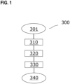
- figure 1 shows an exemplary embodiment of the method 300 according to the invention in the form of a flowchart. In the following, it is explained, among other things, how, for example, the creation 330 of the first map takes place, starting from the map data.
- step 301 the method 300 begins.
- step 310 a second map is provided, the second map including at least one predetermined path (100).
- the second map is a so-called planning map, for example, which contains semantic information about a road section (connectivity between lanes, classification of the lanes, etc.).
- the first map is, for example, what is known as a localization map, which is designed in such a way that a vehicle can localize itself with great precision using this map.
- High-precision localization means, for example, determining a position in GNSS coordinates that is accurate to within a few centimeters (maximum +/- 10 cm). This has the advantage, for example, that—if the first and the second map are aligned with one another after the method 300 has been carried out—it is possible to use both maps at the same time to locate an (automated) vehicle and to determine the position within the planning map.
- step 320 map data is received, the map data representing at least one trajectory (200) and at least one further object.
- the first map can be created, at least one trajectory (200) is required for this purpose, which is received for this purpose, for example from a vehicle.
- a plurality of trajectories (200) are received, for example, with this plurality of trajectories (200) for example by means of a Vehicle fleet departed, stored and - directly or indirectly - transferred to the inventive device for performing the inventive method 300.
- the plurality of trajectories (200) is optimized using, in particular, a SLAM method, which results in an optimized trajectory being created.
- an optimized trajectory is created for each lane of a traffic route, for example.
- step 330 the first map is created based on the map data.
- An alignment based on a superimposition of the at least one specified path (100) and the at least one trajectory (200) is carried out.
- the at least one further object is then displaced, starting from the alignment. This means, for example, an adjustment of the coordinates of the at least one further object by means of vector addition.
- the ultimate purpose of alignment and translation is to create the first map in such a way that it aligns with the second map. This alignment is done, for example, because the contents of the first and second cards are to be combined. In a further embodiment, the alignment is carried out because any faulty partial data sets of the map data that may be present can thereby be corrected.
- step 340 the method 300 ends.
- figure 2 shows an example of the orientation of the at least one (three in this example) trajectory (200) [ Figure 2a ] on the at least one (here also three as an example) predetermined path (100) [ Figure 2b ].
- This is done, for example, using a suitable algorithm or suitable software (for example based on mathematical optimization methods), which optimally aligns the at least one trajectory (200) with the at least one specified path (100) [ Figure 2c ].
- This alignment is an approximation, for example, since the at least one trajectory (200) and the at least one specified path (100) are not exactly identical or do not have an exactly identical course.
- the displacement can now take place, ie, for example, the adjustment of the first card and the second card to one another. In the following, for example, both cards can now be used together.
Landscapes
- Engineering & Computer Science (AREA)
- Remote Sensing (AREA)
- Radar, Positioning & Navigation (AREA)
- Automation & Control Theory (AREA)
- Physics & Mathematics (AREA)
- General Physics & Mathematics (AREA)
- Computer Vision & Pattern Recognition (AREA)
- Databases & Information Systems (AREA)
- Navigation (AREA)
- Instructional Devices (AREA)
- Traffic Control Systems (AREA)
Description
- Die vorliegende Erfindung betrifft unter anderem ein Verfahren zum Erstellen einer ersten Karte mit einem Schritt des Bereitstellens einer zweiten Karte, einem Schritt des Empfangens von Kartendaten, und einem Schritt des Erstellens der ersten Karte, ausgehend von den Kartendaten, mittels der zweiten Karte.
- Aus dem Dokument
DE 10 2015 225472 A1 sind ein Verfahren und Vorrichtungen zum Erstellen einer Karte bekannt, wobei wenigstens zwei Umgebungsdatensätze erfasst und darauf basierend zwei Teilkarten erstellt werden und die Karte basierend auf den wenigstens zwei Umgebungsdatensätzen und den wenigstens zwei Teilkarten erstellt wird. - Das Dokument
DE 10 2013 208521 A1 offenbart ein Erstellen eines Straßenmodells basierend auf Trajektoriendaten und Perzeptionsdaten, wobei für die Trajektorie eine optimale Schätzung von Trajektorienpunkten erfolgen kann. - Das erfindungsgemäße Verfahren zum Erstellen einer ersten Karte gemäß Anspruch 1 umfasst einen Schritt des Bereitstellens einer zweiten Karte, wobei die zweite Karte wenigstens einen vorgegebenen Weg umfasst, einen Schritt des Empfangens von Kartendaten, wobei die Kartendaten wenigstens eine Trajektorie und wenigstens ein weiteres Objekt repräsentieren, von mindestens einem Fahrzeug, welches die wenigstens eine Trajektorie abfährt und zeitgleich das wenigstens eine weitere Objekt mittels einer Umfeldsensorik erfasst, wobei die wenigstens eine Trajektorie eine optimierte Trajektorie darstellt, welche vorab mittels eines SLAM-Verfahrens, ausgehend von einer Vielzahl von Trajektorien, ermittelt wird, wobei unter der Vielzahl von Trajektorien mehrere Trajektorien einer Vielzahl von Fahrten zu verstehen sind, wobei sich jede Trajektorie auf eine vergleichbare Fahrt, beispielsweise auf eine bestimmte Fahrspur eines Verkehrsweges entlang desselben Streckenabschnitts, bezieht, und einen Schritt des Erstellens der ersten Karte, ausgehend von der Kartendaten, wobei eine Ausrichtung, welche auf einer Überlagerung des wenigstens einen vorgegebenen Wegs und der wenigstens einen Trajektorie basiert, ausgeführt wird und anschließend eine Verschiebung des wenigstens einen weiteren Objekts, ausgehend von der Ausrichtung, ausgeführt wird.
- Unter einer ersten und/oder zweiten Karte ist beispielsweise eine digitale Karte zu verstehen, welche in Form von (Karten-) Datenwerten auf einem Speichermedium vorliegt. Diese Karte ist beispielsweise derart ausgebildet, dass eine oder mehrere Kartenschichten umfasst werden, wobei eine Kartenschicht beispielsweise eine Karte aus der Vogelperspektive (Verlauf und Position von Straßen, Gebäuden,
Landschaftsmerkmalen, etc.) zeigt. Dies entspricht beispielsweise einer Karte eines Navigationssystems. Eine weitere Kartenschicht umfasst beispielsweise eine Radarkarte, wobei Umgebungsmerkmale, welche von der Radarkarte abgebildet werden, mit einer Radarsignatur hinterlegt sind. Eine weitere Kartenschicht umfasst beispielsweise eine Lidarkarte, wobei Umgebungsmerkmale, welche von der Lidarkarte abgebildet werden, mit einer Lidarpunktwolke und/oder -objekten hinterlegt sind. Eine weitere Kartenschicht umfasst beispielsweise eine Videokarte, wobei Umgebungsmerkmale, welche von der Videokarte abgebildet werden, mit von einem Videosensor erkennbaren Objekten hinterlegt sind. - In einer Ausführungsform ist zusätzlich oder alternativ unter einer ersten und/oder zweiten Karte beispielsweise eine Karte zu verstehen, welche dazu geeignet ist, ein Fahrzeug automatisiert zu betreiben. Unter einem automatisierten Betreiben eines Fahrzeugs ist zu verstehen, dass das Fahrzeug teil-, hoch- oder vollautomatisiert - entsprechend einem der SAE-Level 1 bis 5 - betrieben wird (siehe Norm SAE J3016). Dabei umfasst das Betreiben des Fahrzeugs mittels der Karte beispielsweise das Bestimmen einer Trajektorie für das Fahrzeug und/oder das Abfahren dieser Trajektorie mittels einer automatisierten Quer- und/oder Längssteuerung und/oder das Ausführen sicherheitsrelevanter Fahrfunktionen etc.
- Unter einem Bereitstellen der zweiten Karte ist beispielsweise zu verstehen, dass diese zweite Karte in Form von Datenwerten von einem Speichermedium oder einer externen Quelle (herunter-) geladen wird, so dass diese zum Ausführen des Verfahrens verwendet werden kann.
- Unter einem vorgegebenen Weg ist beispielsweise eine ausgezeichnete Linie innerhalb oder entlang einer von der zweiten Karte umfassten Fahrspur zu verstehen. In einer Ausführungsform umfasst die zweite Karte beispielsweise eine mehrspurige Straße, wobei jede Fahrspur einen eindeutigen Verlauf sowie eine eindeutige Ausdehnung (beispielsweise in Form einer konstanten und/oder variierenden Breite) aufweist. Dabei entspricht der vorgegebene Weg beispielsweise einer Linie welche in Richtung dieser Fahrspur in der Mitte verläuft (also einen gleichen bzw. vergleichbaren Abstand zum linken und rechten Rand der Fahrspur aufweist,). In einer Ausführungsform ist unter einem vorgegebenen Weg beispielsweise eine Verkettung von Punkten zu verstehen, welche an ausgezeichneten Orten entlang des Weges bzw. innerhalb oder außerhalb der Fahrspur ortsgenau vorgegeben sind. In einer Ausführungsform ist unter einem vorgegebenen Weg beispielsweise eine geometrische Linie zu verstehen, welche an ausgezeichneten Orten entlang des Weges innerhalb oder außerhalb der Fahrspur ortsgenau vorgegeben ist.
- Unter Kartendaten sind Daten zu verstehen, welche wenigstens eine Trajektorie und wenigstens ein weiteres Objekt repräsentieren. Dabei werden diese Daten von mindestens einem Fahrzeug, welches diese Trajektorie abfährt und zeitgleich das wenigstens eine weitere Objekt mittels einer - von dem Fahrzeug umfassten - Umfeldsensorik erfasst hat, bereitgestellt.
- In einer Ausführungsform fährt das Fahrzeug beispielsweise die Trajektorie ab, wobei diese Trajektorie zeitgleich mittels einer Lokalisierungseinrichtung - beispielsweise als GPS-Positionen in GNSS-Koordinaten - erfasst und gespeichert wird. Weiterhin umfasst das Fahrzeug mittels einer Umfeldsensorik seine Umgebung. Unter einer Umfeldsensorik ist wenigstens ein Video- und/oder wenigstens ein Radar- und/oder wenigstens ein Lidar- und/oder wenigstens ein Ultraschall- und/oder wenigstens ein weiterer Sensor zu verstehen, welcher dazu ausgebildet ist, die Umgebung des Fahrzeugs in Form von Umgebungsdatenwerten zu erfassen.
- Unter einer Umgebung des Fahrzeugs ist beispielsweise wenigstens ein Bereich zu verstehen, welche mittels der Umfeldsensorik des Fahrzeugs erfasst werden kann. Unter einer Umgebung kann auch ein Straßenabschnitt und/oder größere Bereiche (Ortsteile, Regionen, etc.) zu verstehen sein. Unter dem wenigstens einen weiteren Objekt ist beispielsweise ein Bauwerk (Gebäude, Tunnel, Brücke, etc.) und/oder ein Verkehrszeichen (Ampelanlage, Schilder, etc.) und/oder eine Infrastruktureinrichtung (Leitplanke, Fahrbahnmarkierung, etc.) und/oder ein Landschaftsmerkmal (Berg, See, Fluss, Wald, etc.) und/oder weitere Umgebungsmerkmale zu verstehen.
- Das wenigstens eine weitere Objekt wird dabei erfasst und mit einer Position, welche beispielsweise ausgehend von der Position des Fahrzeugs vektoriell, mittels einer Entfernung und/oder einer Richtung des wenigstens einen weiteren Objekts relativ zu dem Fahrzeug, bestimmt wird, in dem Fahrzeug als Kartendaten gespeichert.
- Unter einem Empfangen der Kartendaten ist beispielsweise zu verstehen, dass diese Kartendaten mittels einer Sende- und/oder Empfangseinheit direkt von dem Fahrzeug, welches diese Kartendaten bereitstellt, oder von einer weiteren Recheneinheit, welche die Kartendaten vorab direkt oder indirekt von dem Fahrzeug empfangen hat, empfängt. In einer Ausführungsform werden die Kartendaten vorab empfangen und zum Ausführen des Verfahrens - beispielsweise von einem Speichermedium - geladen.
- Das erfindungsgemäße Verfahren löst vorteilhafterweise die Aufgabe, die Zuverlässigkeit und Genauigkeit von Kartendaten zu verbessern. Dies ist insbesondere für das Nutzen der ersten Karte für das automatisierte Fahren von großer Bedeutung, da somit ein zuverlässigeres bzw. sichereres Betreiben eines Fahrzeugs, abhängig von dieser ersten Karte, gewährleistet werden kann. Dies ist gerade auch für die Akzeptanz des automatisierten Fahrens enorm wichtig ist, da somit die Gewährleistung der Sicherheit der Insassen und des Fahrzeugs weiter gesteigert werden kann. Das erfindungsgemäße Verfahren löst diese Aufgabe mittels der beanspruchten Merkmale.
- Erfindungsgemäß stellt die wenigstens eine Trajektorie eine optimierte Trajektorie dar, welche vorab mittels eines SLAM-Verfahrens, ausgehend von einer Vielzahl von Trajektorien, ermittelt wird.
- Unter einer Vielzahl von Trajektorien sind mehrere Trajektorien einer Vielzahl von Fahrten zu verstehen, wobei sich jede Trajektorie auf eine vergleichbare Fahrt, beispielsweise auf eine bestimmte Fahrspur eines Verkehrsweges entlang desselben Streckenabschnitts, bezieht. Diese einzelnen Trajektorien werden anschließend mittels eines SLAM-Verfahren ("Simultaneous Localization and Mapping") miteinander assoziiert und anschließend gemeinsam optimiert. Dies führt vorteilhafterweise dazu, dass die optimierte Trajektorie präziser ist, als eine einzelne Trajektorie. Beispielsweise können somit fehlerhafte Angaben einzelner Trajektorien (beispielsweise bezogen auf einzelne Positionskoordinatenentlang dieser Trajektorien) vermieden bzw. verringert werden.
- Vorzugsweise umfassen die Kartendaten wenigstens zwei Trajektorien und umfasst die zweite Karte wenigstens zwei vorgegebene Wege, wobei die Ausrichtung auf einer Überlagerung der wenigstens zwei vorgegebenen Wege und der wenigstens zwei Trajektorien basiert, wobei insbesondere jeder vorgegebene Weg und jede Trajektorie jeweils einer Fahrspur eines Verkehrsweges zugeordnet ist.
- Hierin zeigt sich der Vorteil, dass die Ausrichtung genauer bestimmt und somit die Qualität bzw. Genauigkeit der ersten Karte verbessert werden kann.
- Die erfindungsgemäße Vorrichtung, insbesondere eine Recheneinheit, ist dazu eingerichtet, alle Schritte des Verfahrens gemäß einem der Verfahrensansprüche auszuführen.
- In einer Ausführungsform umfasst die Vorrichtung eine Recheneinheit (Prozessor, Arbeitsspeicher, Festplatte) sowie eine geeignete Software (Computerprogramm) um das Verfahren gemäß einem der Verfahrensansprüche auszuführen. In einer Ausführungsform umfasst die Vorrichtung eine Sende- und/oder Empfangseinheit, welche dazu ausgebildet ist, (Karten-) Datenwerte - insbesondere mit einem Fahrzeug und/oder externen Server bzw. einer Cloud - auszutauschen. In einer weiteren Ausführungsform ist die Vorrichtung als Server bzw. Cloud (also einem Verbund von Servern bzw. Recheneinheiten) - ausgebildet.
- Weiterhin wird ein Computerprogramm beansprucht, umfassend Befehle, die bei der Ausführung des Computerprogramms durch einen Computer diesen veranlassen, ein Verfahren gemäß einem der Verfahrensansprüche auszuführen.
- Weiterhin wird ein maschinenlesbares Speichermedium, auf dem das Computerprogramm gespeichert ist, beansprucht.
- Vorteilhafte Weiterbildungen der Erfindung sind in den Unteransprüchen angegeben und in der Beschreibung aufgeführt.
- Ausführungsbeispiele der Erfindung sind in den Zeichnungen dargestellt und werden in den nachfolgenden Beschreibungen näher erläutert. Es zeigen:
-
Figur 1 ein Ausführungsbeispiel des erfindungsgemäßen Verfahrens in Form eines Ablaufdiagramms; und -
Figur 2 (Fig. 2a und 2b ) ein Ausführungsbeispiels des erfindungsgemäßen Verfahrens. -
Figur 1 zeigt ein Ausführungsbeispiel des erfindungsgemäßen Verfahrens 300 in Form eines Ablaufdiagramms. Im Folgenden wird dabei unter anderem erläutert, wie beispielsweise das Erstellen 330 der ersten Karte, ausgehend von den Kartendaten, erfolgt. - In Schritt 301 beginnt das Verfahren 300.
- In Schritt 310 wird eine zweite Karte bereitgestellt, wobei die zweite Karte wenigstens einen vorgegebenen Weg (100) umfasst.
- In einer möglichen Ausführungsform handelt es sich bei der zweiten Karte beispielsweise um eine sogenannte Planungskarte, welche semantische Informationen über einen Straßenabschnitt (Konnektivitäten zwischen Fahrspuren, Klassifikation der Fahrspuren, etc.) enthält. Bei der ersten Karte handelt es sich beispielsweise um eine sogenannte Lokalisierungskarte, welche derart ausgebildet ist, dass ein Fahrzeug sich hochgenau mithilfe dieser Karte lokalisieren kann. Unter einem hochgenauen Lokalisieren ist beispielsweise eine Positionsbestimmung in GNSS-Koordinaten zu verstehen, welche bis auf wenige Zentimeter (maximal +/- 10cm) genau ist. Dies hat beispielsweise den Vorteil, dass - wenn die erste und die zweite Karte nach Ausführen des Verfahrens 300 zueinander ausgerichtet sind - es mithilfe beider Karten zeitgleich möglich ist, sich für ein (automatisierten) Fahrzeug zu lokalisieren und die Position innerhalb der Planungskarte zu bestimmen.
- In Schritt 320 werden Kartendaten empfangen, wobei die Kartendaten wenigstens eine Trajektorie (200) und wenigstens ein weiteres Objekt repräsentieren.
- Damit die erste Karte erstellt werden kann, wird hierfür wenigstens eine Trajektorie (200) benötigt, welche dazu - beispielsweise von einem Fahrzeug - empfangen wird. In einer möglichen Ausführungsform werden beispielsweise eine Vielzahl von Trajektorien (200) empfangen, wobei diese Vielzahl von Trajektorien (200) beispielsweise mittels einer Fahrzeugflotte abgefahren, gespeichert und - direkt oder indirekt - an die erfindungsgemäße Vorrichtung zum Ausführen des erfindungsgemäßen Verfahrens 300 übertragen werden. Anschließend wird ausgehend von der Vielzahl von Trajektorien (200), mittels insbesondere einem SLAM-Verfahren eine Optimierung der Vielzahl von Trajektorien (200) ausgeführt, welche dazu führt, dass eine optimierte Trajektorie erstellt wird. In einer möglichen Ausführungsform wird beispielsweise eine optimierte Trajektorie pro Fahrspur eines Verkehrsweges erstellt.
- In Schritt 330 wird die erste Karte, ausgehend von den Kartendaten, erstellt. Dabei wird eine Ausrichtung, welche auf einer Überlagerung des wenigstens einen vorgegebenen Wegs (100) und der wenigstens einen Trajektorie (200) basiert, ausgeführt. Anschließend wird eine Verschiebung des wenigstens einen weiteren Objekts, ausgehend von der Ausrichtung, ausgeführt. Darunter ist beispielsweise eine Anpassung der Koordinaten des wenigstens einen weiteren Objekts mittels Vektoraddition zu verstehen.
- Die Ausrichtung und die Verschiebung dienen letztendlich dazu, die erste Karte derart zu erstellen, dass diese an der zweiten Karte ausgerichtet wird. Diese Ausrichtung wird beispielsweise deshalb vorgenommen, weil die Inhalte der ersten und der zweiten Karte kombiniert werden sollen. In einer weiteren Ausführungsform erfolgt das Ausrichten deshalb, weil dadurch eventuell vorhandene fehlerhafte Teildatensätze der Kartendaten korrigiert werden können.
- In Schritt 340 endet das Verfahren 300.
-
Figur 2 zeigt ein Beispiel der Ausrichtung der wenigstens einen (hier beispielhaft drei) Trajektorie (200) [Fig. 2a ] an dem wenigstens einen (hier ebenfalls beispielshaft drei) vorgegebenen Weges (100) [Fig. 2b ]. Dies geschieht beispielsweise mittels eines geeigneten Algorithmus bzw. einer geeigneten Software (beispielsweise basierend auf mathematischen Optimierungsverfahren), welcher die wenigstens eine Trajektorie (200) optimal an dem wenigstens einen vorgegebenen Weg (100) ausrichtet [Fig. 2c ]. Diese Ausrichtung ist beispielsweise eine Annäherung, da die wenigstens eine Trajektorie (200) und der wenigstens eine vorgegebene Weg (100) nicht exakt identisch sind bzw. keinen exakt identischen Verlauf haben. Ausgehend von der Ausrichtung kann nun die Verschiebung, also beispielsweise das Anpassen der ersten Karte und der zweiten Karte zueinander, erfolgen. Im Folgenden können nun beispielsweise beide Karten gemeinsam verwendet werden.
Claims (5)
- Verfahren (300) zum Erstellen einer ersten Karte, umfassend:- Bereitstellen (310) einer zweiten Karte, wobei die zweite Karte wenigstens einen vorgegebenen Weg (100) umfasst;- Empfangen (320) von Kartendaten, wobei die Kartendaten wenigstens eine Trajektorie (200) und wenigstens ein weiteres Objekt repräsentieren, von mindestens einem Fahrzeug, welches die wenigstens eine Trajektorie (200) abfährt und zeitgleich das wenigstens eine weitere Objekt mittels einer Umfeldsensorik erfasst, wobei die wenigstens eine Trajektorie (200) eine optimierte Trajektorie darstellt, welche vorab mittels eines SLAM-Verfahrens, ausgehend von einer Vielzahl von Trajektorien (200), ermittelt wird, wobei unter der Vielzahl von Trajektorien mehrere Trajektorien einer Vielzahl von Fahrten zu verstehen sind, wobei sich jede Trajektorie auf eine vergleichbare Fahrt, beispielsweise auf eine bestimmte Fahrspur eines Verkehrsweges entlang desselben Streckenabschnitts, bezieht; und- Erstellen (330) der ersten Karte, ausgehend von den Kartendaten, wobei eine Ausrichtung, welche auf einer Überlagerung des wenigstens einen vorgegebenen Wegs (100) und der wenigstens einen Trajektorie (200) basiert, ausgeführt wird und anschließend eine Verschiebung des wenigstens einen weiteren Objekts, ausgehend von der Ausrichtung, ausgeführt wird.
- Verfahren (300) nach Anspruch 1, dadurch gekennzeichnet, dass die Kartendaten wenigstens zwei Trajektorien (200) umfassen und die zweite Karte wenigstens zwei vorgegebene (100) Wege umfasst, wobei die Ausrichtung auf einer Überlagerung der wenigstens zwei vorgegebenen Wege (100) und der wenigstens zwei Trajektorien (200) basiert, wobei insbesondere jeder vorgegebene Weg (100) und jede Trajektorie (200) jeweils einer Fahrspur eines Verkehrsweges zugeordnet ist.
- Vorrichtung, insbesondere eine Recheneinheit, die eingerichtet ist, alle Schritte des Verfahrens (300) gemäß einem der Ansprüche 1 bis 2 auszuführen.
- Computerprogramm, umfassend Befehle, die bei der Ausführung des Computerprogramms durch einen Computer diesen veranlassen, ein Verfahren (300) gemäß einem der Ansprüche 1 bis 2 auszuführen.
- Maschinenlesbares Speichermedium, auf dem das Computerprogramm nach Anspruch 4 gespeichert ist.
Applications Claiming Priority (2)
| Application Number | Priority Date | Filing Date | Title |
|---|---|---|---|
| DE102019206336.5A DE102019206336A1 (de) | 2019-05-03 | 2019-05-03 | Verfahren und Vorrichtung zum Erstellen einer ersten Karte |
| PCT/EP2020/059356 WO2020224878A1 (de) | 2019-05-03 | 2020-04-02 | Verfahren und vorrichtung zum erstellen einer ersten karte |
Publications (2)
| Publication Number | Publication Date |
|---|---|
| EP3963287A1 EP3963287A1 (de) | 2022-03-09 |
| EP3963287B1 true EP3963287B1 (de) | 2023-06-07 |
Family
ID=70277353
Family Applications (1)
| Application Number | Title | Priority Date | Filing Date |
|---|---|---|---|
| EP20718239.5A Active EP3963287B1 (de) | 2019-05-03 | 2020-04-02 | Verfahren und vorrichtung zum erstellen einer ersten karte |
Country Status (6)
| Country | Link |
|---|---|
| US (1) | US12553724B2 (de) |
| EP (1) | EP3963287B1 (de) |
| JP (1) | JP7260668B2 (de) |
| CN (1) | CN113950613B (de) |
| DE (1) | DE102019206336A1 (de) |
| WO (1) | WO2020224878A1 (de) |
Families Citing this family (2)
| Publication number | Priority date | Publication date | Assignee | Title |
|---|---|---|---|---|
| EP3875909B1 (de) * | 2020-03-05 | 2022-02-23 | Sick Ag | Erzeugen einer neuen hybriden karte zur navigation |
| DE102023109572A1 (de) | 2023-04-17 | 2024-10-17 | Valeo Schalter Und Sensoren Gmbh | Verfahren zum Detektieren einer Position eines wenigstens teilweise automatisierten Kraftfahrzeugs durch eine Positionsdetektionsvorrichtung, Computerprogrammprodukt, computerlesbares Speichermedium, Positionsdetektionsvorrichtung sowie Assistenzsystem |
Citations (4)
| Publication number | Priority date | Publication date | Assignee | Title |
|---|---|---|---|---|
| US6502033B1 (en) * | 2000-10-05 | 2002-12-31 | Navigation Technologies Corp. | Turn detection algorithm for vehicle positioning |
| DE102013208521A1 (de) * | 2013-05-08 | 2014-11-13 | Bayerische Motoren Werke Aktiengesellschaft | Kollektives Erlernen eines hochgenauen Straßenmodells |
| DE102015225472A1 (de) * | 2015-12-16 | 2017-06-22 | Robert Bosch Gmbh | Verfahren und Vorrichtung zum Erstellen einer Karte |
| DE102017210798A1 (de) * | 2017-06-27 | 2018-12-27 | Continental Automotive Gmbh | Verfahren und Einrichtung zur Erzeugung von digitalen Kartenmodellen |
Family Cites Families (9)
| Publication number | Priority date | Publication date | Assignee | Title |
|---|---|---|---|---|
| JP3143927B2 (ja) | 1996-09-20 | 2001-03-07 | トヨタ自動車株式会社 | 位置情報提供システム及び装置 |
| US6687611B1 (en) * | 1999-09-07 | 2004-02-03 | Robert Bosch Gmbh | Method for coding and decoding objects in a road traffic network |
| JP5064870B2 (ja) * | 2007-04-17 | 2012-10-31 | 株式会社日立製作所 | デジタル道路地図の生成方法及び地図生成システム |
| US10466056B2 (en) | 2014-04-25 | 2019-11-05 | Samsung Electronics Co., Ltd. | Trajectory matching using ambient signals |
| DE102015218042A1 (de) * | 2015-09-21 | 2017-03-23 | Bayerische Motoren Werke Aktiengesellschaft | Verfahren und Vorrichtung zum Betreiben eines Fahrzeugs und Fahrerassistenzsystem |
| CN110062871B (zh) * | 2016-12-09 | 2024-01-19 | 通腾全球信息公司 | 用于基于视频的定位及映射的方法及系统 |
| DE102017208509A1 (de) * | 2017-05-19 | 2018-11-22 | Bayerische Motoren Werke Aktiengesellschaft | Verfahren zum Erzeugen eines Straßenmodells während einer Fahrt eines Kraftfahrzeugs sowie Steuervorrichtung und Kraftfahrzeug |
| JP6662828B2 (ja) * | 2017-09-08 | 2020-03-11 | 本田技研工業株式会社 | 運転支援システム、運転支援装置および運転支援方法 |
| US10782136B2 (en) * | 2018-09-28 | 2020-09-22 | Zoox, Inc. | Modifying map elements associated with map data |
-
2019
- 2019-05-03 DE DE102019206336.5A patent/DE102019206336A1/de not_active Withdrawn
-
2020
- 2020-04-02 JP JP2021564962A patent/JP7260668B2/ja active Active
- 2020-04-02 US US17/606,679 patent/US12553724B2/en active Active
- 2020-04-02 EP EP20718239.5A patent/EP3963287B1/de active Active
- 2020-04-02 WO PCT/EP2020/059356 patent/WO2020224878A1/de not_active Ceased
- 2020-04-02 CN CN202080033454.2A patent/CN113950613B/zh active Active
Patent Citations (4)
| Publication number | Priority date | Publication date | Assignee | Title |
|---|---|---|---|---|
| US6502033B1 (en) * | 2000-10-05 | 2002-12-31 | Navigation Technologies Corp. | Turn detection algorithm for vehicle positioning |
| DE102013208521A1 (de) * | 2013-05-08 | 2014-11-13 | Bayerische Motoren Werke Aktiengesellschaft | Kollektives Erlernen eines hochgenauen Straßenmodells |
| DE102015225472A1 (de) * | 2015-12-16 | 2017-06-22 | Robert Bosch Gmbh | Verfahren und Vorrichtung zum Erstellen einer Karte |
| DE102017210798A1 (de) * | 2017-06-27 | 2018-12-27 | Continental Automotive Gmbh | Verfahren und Einrichtung zur Erzeugung von digitalen Kartenmodellen |
Also Published As
| Publication number | Publication date |
|---|---|
| JP7260668B2 (ja) | 2023-04-18 |
| JP2022530565A (ja) | 2022-06-29 |
| DE102019206336A1 (de) | 2020-11-05 |
| EP3963287A1 (de) | 2022-03-09 |
| WO2020224878A1 (de) | 2020-11-12 |
| US12553724B2 (en) | 2026-02-17 |
| CN113950613A (zh) | 2022-01-18 |
| US20220205792A1 (en) | 2022-06-30 |
| CN113950613B (zh) | 2024-09-13 |
Similar Documents
| Publication | Publication Date | Title |
|---|---|---|
| EP3491339B1 (de) | Verfahren, vorrichtung und computerlesbares speichermedium mit instruktionen zur bestimmung der lateralen position eines fahrzeuges relativ zu den fahrstreifen einer fahrbahn | |
| EP3814720B1 (de) | Lokalisierungssystem und verfahren zum betreiben desselben | |
| EP3380810B1 (de) | Verfahren, vorrichtung, kartenverwaltungseinrichtung und system zum punktgenauen lokalisieren eines kraftfahrzeugs in einem umfeld | |
| DE102016213817B4 (de) | Verfahren, Vorrichtung und computerlesbares Speichermedium mit Instruktionen zur Bestimmung der lateralen Position eines Fahrzeuges relativ zu den Fahrstreifen einer Fahrbahn | |
| EP3465088B1 (de) | Verfahren, vorrichtung und computerlesbares speichermedium mit instruktionen zur bestimmung der lateralen position eines fahrzeuges relativ zu den fahrstreifen einer fahrbahn | |
| DE102018107935A1 (de) | Vorrichtung zur Bestimmung der Operational Design Domain (ODD) | |
| EP3609755B1 (de) | Fahrerassistenzsystem für ein fahrzeug | |
| EP3577419A1 (de) | Verfahren zur lokalisierung eines höher automatisierten, z.b. hochautomatisierten fahrzeugs (haf) in einer digitalen lokalisierungskarte | |
| DE112018004003T5 (de) | Steuerung und verfahren zum automatischen fahren | |
| EP3990863A1 (de) | Angleichen von koordinatensystemen mehrerer karten basierend auf trajektorien | |
| DE102017220242A1 (de) | Verfahren und Vorrichtung zum Erstellen und Bereitstellen einer Karte | |
| WO2022002564A1 (de) | Ermitteln einer ausgangsposition eines fahrzeugs für eine lokalisierung | |
| EP3963287B1 (de) | Verfahren und vorrichtung zum erstellen einer ersten karte | |
| DE102014216276A1 (de) | Positionsbestimmung von Kraftfahrzeugen mittels Radarbaken | |
| EP3980724A1 (de) | Verfahren zum erstellen einer universell einsetzbaren merkmalskarte | |
| DE102022203264A1 (de) | Verfahren zum Erstellen von Kartendaten | |
| WO2024240427A1 (de) | Verfahren zur erstellung einer digitalen karte | |
| DE112020004203T5 (de) | Fahrzeugpositionsbestimmungsvorrichtung und Fahrzeugpositionsbestimmungsverfahren | |
| DE102018210712A1 (de) | System und Verfahren zur gleichzeitigen Lokalisierung und Kartierung | |
| EP3969846B1 (de) | Verfahren zum validieren einer kartenaktualität | |
| DE102022202165B4 (de) | Verfahren zum Bereitstellen einer Fahrstreifenlokalisierung für ein Kraftfahrzeug in einem Gebiet einer Infrastruktureinrichtung | |
| WO2023186457A1 (de) | Verfahren zur verfügbarkeitsvorhersage einer merkmalbasierten lokalisierung eines fahrzeugs und verfahren zum steuern eines fahrzeugs | |
| DE102019135646B4 (de) | Bestimmen einer Fahrzeugtrajektorie | |
| DE102017011982A1 (de) | Verfahren zur Streckenvorausschau | |
| DE102020215992A1 (de) | Verfahren und Vorrichtung zum Betreiben eines automatisierten Fahrzeugs |
Legal Events
| Date | Code | Title | Description |
|---|---|---|---|
| STAA | Information on the status of an ep patent application or granted ep patent |
Free format text: STATUS: UNKNOWN |
|
| STAA | Information on the status of an ep patent application or granted ep patent |
Free format text: STATUS: THE INTERNATIONAL PUBLICATION HAS BEEN MADE |
|
| PUAI | Public reference made under article 153(3) epc to a published international application that has entered the european phase |
Free format text: ORIGINAL CODE: 0009012 |
|
| STAA | Information on the status of an ep patent application or granted ep patent |
Free format text: STATUS: REQUEST FOR EXAMINATION WAS MADE |
|
| 17P | Request for examination filed |
Effective date: 20211203 |
|
| AK | Designated contracting states |
Kind code of ref document: A1 Designated state(s): AL AT BE BG CH CY CZ DE DK EE ES FI FR GB GR HR HU IE IS IT LI LT LU LV MC MK MT NL NO PL PT RO RS SE SI SK SM TR |
|
| DAV | Request for validation of the european patent (deleted) | ||
| DAX | Request for extension of the european patent (deleted) | ||
| RIC1 | Information provided on ipc code assigned before grant |
Ipc: G01C 21/00 20060101ALI20230117BHEP Ipc: G01C 21/36 20060101ALI20230117BHEP Ipc: G01C 21/32 20060101AFI20230117BHEP |
|
| GRAP | Despatch of communication of intention to grant a patent |
Free format text: ORIGINAL CODE: EPIDOSNIGR1 |
|
| STAA | Information on the status of an ep patent application or granted ep patent |
Free format text: STATUS: GRANT OF PATENT IS INTENDED |
|
| INTG | Intention to grant announced |
Effective date: 20230310 |
|
| GRAS | Grant fee paid |
Free format text: ORIGINAL CODE: EPIDOSNIGR3 |
|
| GRAA | (expected) grant |
Free format text: ORIGINAL CODE: 0009210 |
|
| STAA | Information on the status of an ep patent application or granted ep patent |
Free format text: STATUS: THE PATENT HAS BEEN GRANTED |
|
| AK | Designated contracting states |
Kind code of ref document: B1 Designated state(s): AL AT BE BG CH CY CZ DE DK EE ES FI FR GB GR HR HU IE IS IT LI LT LU LV MC MK MT NL NO PL PT RO RS SE SI SK SM TR |
|
| REG | Reference to a national code |
Ref country code: GB Ref legal event code: FG4D Free format text: NOT ENGLISH |
|
| REG | Reference to a national code |
Ref country code: CH Ref legal event code: EP Ref country code: AT Ref legal event code: REF Ref document number: 1576364 Country of ref document: AT Kind code of ref document: T Effective date: 20230615 |
|
| REG | Reference to a national code |
Ref country code: DE Ref legal event code: R096 Ref document number: 502020003677 Country of ref document: DE |
|
| REG | Reference to a national code |
Ref country code: LT Ref legal event code: MG9D |
|
| REG | Reference to a national code |
Ref country code: NL Ref legal event code: MP Effective date: 20230607 |
|
| PG25 | Lapsed in a contracting state [announced via postgrant information from national office to epo] |
Ref country code: SE Free format text: LAPSE BECAUSE OF FAILURE TO SUBMIT A TRANSLATION OF THE DESCRIPTION OR TO PAY THE FEE WITHIN THE PRESCRIBED TIME-LIMIT Effective date: 20230607 Ref country code: NO Free format text: LAPSE BECAUSE OF FAILURE TO SUBMIT A TRANSLATION OF THE DESCRIPTION OR TO PAY THE FEE WITHIN THE PRESCRIBED TIME-LIMIT Effective date: 20230907 Ref country code: ES Free format text: LAPSE BECAUSE OF FAILURE TO SUBMIT A TRANSLATION OF THE DESCRIPTION OR TO PAY THE FEE WITHIN THE PRESCRIBED TIME-LIMIT Effective date: 20230607 |
|
| PG25 | Lapsed in a contracting state [announced via postgrant information from national office to epo] |
Ref country code: RS Free format text: LAPSE BECAUSE OF FAILURE TO SUBMIT A TRANSLATION OF THE DESCRIPTION OR TO PAY THE FEE WITHIN THE PRESCRIBED TIME-LIMIT Effective date: 20230607 Ref country code: NL Free format text: LAPSE BECAUSE OF FAILURE TO SUBMIT A TRANSLATION OF THE DESCRIPTION OR TO PAY THE FEE WITHIN THE PRESCRIBED TIME-LIMIT Effective date: 20230607 Ref country code: LV Free format text: LAPSE BECAUSE OF FAILURE TO SUBMIT A TRANSLATION OF THE DESCRIPTION OR TO PAY THE FEE WITHIN THE PRESCRIBED TIME-LIMIT Effective date: 20230607 Ref country code: LT Free format text: LAPSE BECAUSE OF FAILURE TO SUBMIT A TRANSLATION OF THE DESCRIPTION OR TO PAY THE FEE WITHIN THE PRESCRIBED TIME-LIMIT Effective date: 20230607 Ref country code: HR Free format text: LAPSE BECAUSE OF FAILURE TO SUBMIT A TRANSLATION OF THE DESCRIPTION OR TO PAY THE FEE WITHIN THE PRESCRIBED TIME-LIMIT Effective date: 20230607 Ref country code: GR Free format text: LAPSE BECAUSE OF FAILURE TO SUBMIT A TRANSLATION OF THE DESCRIPTION OR TO PAY THE FEE WITHIN THE PRESCRIBED TIME-LIMIT Effective date: 20230908 |
|
| PG25 | Lapsed in a contracting state [announced via postgrant information from national office to epo] |
Ref country code: FI Free format text: LAPSE BECAUSE OF FAILURE TO SUBMIT A TRANSLATION OF THE DESCRIPTION OR TO PAY THE FEE WITHIN THE PRESCRIBED TIME-LIMIT Effective date: 20230607 |
|
| PG25 | Lapsed in a contracting state [announced via postgrant information from national office to epo] |
Ref country code: SK Free format text: LAPSE BECAUSE OF FAILURE TO SUBMIT A TRANSLATION OF THE DESCRIPTION OR TO PAY THE FEE WITHIN THE PRESCRIBED TIME-LIMIT Effective date: 20230607 |
|
| PG25 | Lapsed in a contracting state [announced via postgrant information from national office to epo] |
Ref country code: IS Free format text: LAPSE BECAUSE OF FAILURE TO SUBMIT A TRANSLATION OF THE DESCRIPTION OR TO PAY THE FEE WITHIN THE PRESCRIBED TIME-LIMIT Effective date: 20231007 |
|
| PG25 | Lapsed in a contracting state [announced via postgrant information from national office to epo] |
Ref country code: SM Free format text: LAPSE BECAUSE OF FAILURE TO SUBMIT A TRANSLATION OF THE DESCRIPTION OR TO PAY THE FEE WITHIN THE PRESCRIBED TIME-LIMIT Effective date: 20230607 Ref country code: SK Free format text: LAPSE BECAUSE OF FAILURE TO SUBMIT A TRANSLATION OF THE DESCRIPTION OR TO PAY THE FEE WITHIN THE PRESCRIBED TIME-LIMIT Effective date: 20230607 Ref country code: RO Free format text: LAPSE BECAUSE OF FAILURE TO SUBMIT A TRANSLATION OF THE DESCRIPTION OR TO PAY THE FEE WITHIN THE PRESCRIBED TIME-LIMIT Effective date: 20230607 Ref country code: PT Free format text: LAPSE BECAUSE OF FAILURE TO SUBMIT A TRANSLATION OF THE DESCRIPTION OR TO PAY THE FEE WITHIN THE PRESCRIBED TIME-LIMIT Effective date: 20231009 Ref country code: IS Free format text: LAPSE BECAUSE OF FAILURE TO SUBMIT A TRANSLATION OF THE DESCRIPTION OR TO PAY THE FEE WITHIN THE PRESCRIBED TIME-LIMIT Effective date: 20231007 Ref country code: EE Free format text: LAPSE BECAUSE OF FAILURE TO SUBMIT A TRANSLATION OF THE DESCRIPTION OR TO PAY THE FEE WITHIN THE PRESCRIBED TIME-LIMIT Effective date: 20230607 Ref country code: CZ Free format text: LAPSE BECAUSE OF FAILURE TO SUBMIT A TRANSLATION OF THE DESCRIPTION OR TO PAY THE FEE WITHIN THE PRESCRIBED TIME-LIMIT Effective date: 20230607 |
|
| PG25 | Lapsed in a contracting state [announced via postgrant information from national office to epo] |
Ref country code: PL Free format text: LAPSE BECAUSE OF FAILURE TO SUBMIT A TRANSLATION OF THE DESCRIPTION OR TO PAY THE FEE WITHIN THE PRESCRIBED TIME-LIMIT Effective date: 20230607 |
|
| REG | Reference to a national code |
Ref country code: DE Ref legal event code: R097 Ref document number: 502020003677 Country of ref document: DE |
|
| PLBE | No opposition filed within time limit |
Free format text: ORIGINAL CODE: 0009261 |
|
| STAA | Information on the status of an ep patent application or granted ep patent |
Free format text: STATUS: NO OPPOSITION FILED WITHIN TIME LIMIT |
|
| PG25 | Lapsed in a contracting state [announced via postgrant information from national office to epo] |
Ref country code: DK Free format text: LAPSE BECAUSE OF FAILURE TO SUBMIT A TRANSLATION OF THE DESCRIPTION OR TO PAY THE FEE WITHIN THE PRESCRIBED TIME-LIMIT Effective date: 20230607 |
|
| PG25 | Lapsed in a contracting state [announced via postgrant information from national office to epo] |
Ref country code: SI Free format text: LAPSE BECAUSE OF FAILURE TO SUBMIT A TRANSLATION OF THE DESCRIPTION OR TO PAY THE FEE WITHIN THE PRESCRIBED TIME-LIMIT Effective date: 20230607 |
|
| 26N | No opposition filed |
Effective date: 20240308 |
|
| PG25 | Lapsed in a contracting state [announced via postgrant information from national office to epo] |
Ref country code: SI Free format text: LAPSE BECAUSE OF FAILURE TO SUBMIT A TRANSLATION OF THE DESCRIPTION OR TO PAY THE FEE WITHIN THE PRESCRIBED TIME-LIMIT Effective date: 20230607 Ref country code: IT Free format text: LAPSE BECAUSE OF FAILURE TO SUBMIT A TRANSLATION OF THE DESCRIPTION OR TO PAY THE FEE WITHIN THE PRESCRIBED TIME-LIMIT Effective date: 20230607 |
|
| PG25 | Lapsed in a contracting state [announced via postgrant information from national office to epo] |
Ref country code: BG Free format text: LAPSE BECAUSE OF FAILURE TO SUBMIT A TRANSLATION OF THE DESCRIPTION OR TO PAY THE FEE WITHIN THE PRESCRIBED TIME-LIMIT Effective date: 20230607 |
|
| PG25 | Lapsed in a contracting state [announced via postgrant information from national office to epo] |
Ref country code: MC Free format text: LAPSE BECAUSE OF FAILURE TO SUBMIT A TRANSLATION OF THE DESCRIPTION OR TO PAY THE FEE WITHIN THE PRESCRIBED TIME-LIMIT Effective date: 20230607 |
|
| PG25 | Lapsed in a contracting state [announced via postgrant information from national office to epo] |
Ref country code: MC Free format text: LAPSE BECAUSE OF FAILURE TO SUBMIT A TRANSLATION OF THE DESCRIPTION OR TO PAY THE FEE WITHIN THE PRESCRIBED TIME-LIMIT Effective date: 20230607 Ref country code: BG Free format text: LAPSE BECAUSE OF FAILURE TO SUBMIT A TRANSLATION OF THE DESCRIPTION OR TO PAY THE FEE WITHIN THE PRESCRIBED TIME-LIMIT Effective date: 20230607 |
|
| REG | Reference to a national code |
Ref country code: CH Ref legal event code: PL |
|
| PG25 | Lapsed in a contracting state [announced via postgrant information from national office to epo] |
Ref country code: LU Free format text: LAPSE BECAUSE OF NON-PAYMENT OF DUE FEES Effective date: 20240402 |
|
| REG | Reference to a national code |
Ref country code: BE Ref legal event code: MM Effective date: 20240430 |
|
| PG25 | Lapsed in a contracting state [announced via postgrant information from national office to epo] |
Ref country code: LU Free format text: LAPSE BECAUSE OF NON-PAYMENT OF DUE FEES Effective date: 20240402 |
|
| PG25 | Lapsed in a contracting state [announced via postgrant information from national office to epo] |
Ref country code: BE Free format text: LAPSE BECAUSE OF NON-PAYMENT OF DUE FEES Effective date: 20240430 |
|
| PG25 | Lapsed in a contracting state [announced via postgrant information from national office to epo] |
Ref country code: BE Free format text: LAPSE BECAUSE OF NON-PAYMENT OF DUE FEES Effective date: 20240430 Ref country code: CH Free format text: LAPSE BECAUSE OF NON-PAYMENT OF DUE FEES Effective date: 20240430 |
|
| PG25 | Lapsed in a contracting state [announced via postgrant information from national office to epo] |
Ref country code: IE Free format text: LAPSE BECAUSE OF NON-PAYMENT OF DUE FEES Effective date: 20240402 |
|
| PGFP | Annual fee paid to national office [announced via postgrant information from national office to epo] |
Ref country code: DE Payment date: 20250624 Year of fee payment: 6 |
|
| PGFP | Annual fee paid to national office [announced via postgrant information from national office to epo] |
Ref country code: FR Payment date: 20250422 Year of fee payment: 6 |
|
| PGFP | Annual fee paid to national office [announced via postgrant information from national office to epo] |
Ref country code: AT Payment date: 20250721 Year of fee payment: 5 |
|
| PG25 | Lapsed in a contracting state [announced via postgrant information from national office to epo] |
Ref country code: CY Free format text: LAPSE BECAUSE OF FAILURE TO SUBMIT A TRANSLATION OF THE DESCRIPTION OR TO PAY THE FEE WITHIN THE PRESCRIBED TIME-LIMIT; INVALID AB INITIO Effective date: 20200402 |
|
| PG25 | Lapsed in a contracting state [announced via postgrant information from national office to epo] |
Ref country code: HU Free format text: LAPSE BECAUSE OF FAILURE TO SUBMIT A TRANSLATION OF THE DESCRIPTION OR TO PAY THE FEE WITHIN THE PRESCRIBED TIME-LIMIT; INVALID AB INITIO Effective date: 20200402 |
|
| PG25 | Lapsed in a contracting state [announced via postgrant information from national office to epo] |
Ref country code: TR Free format text: LAPSE BECAUSE OF FAILURE TO SUBMIT A TRANSLATION OF THE DESCRIPTION OR TO PAY THE FEE WITHIN THE PRESCRIBED TIME-LIMIT Effective date: 20230607 |
|
| PGFP | Annual fee paid to national office [announced via postgrant information from national office to epo] |
Ref country code: GB Payment date: 20260324 Year of fee payment: 7 |