EP3721265B1 - Systeme und verfahren zur verfeinerung von geschätzten parameterwerten in der seismischen bildgebung - Google Patents
Systeme und verfahren zur verfeinerung von geschätzten parameterwerten in der seismischen bildgebung Download PDFInfo
- Publication number
- EP3721265B1 EP3721265B1 EP18797136.1A EP18797136A EP3721265B1 EP 3721265 B1 EP3721265 B1 EP 3721265B1 EP 18797136 A EP18797136 A EP 18797136A EP 3721265 B1 EP3721265 B1 EP 3721265B1
- Authority
- EP
- European Patent Office
- Prior art keywords
- map data
- subsurface
- parameter values
- subsurface map
- seismic
- Prior art date
- Legal status (The legal status is an assumption and is not a legal conclusion. Google has not performed a legal analysis and makes no representation as to the accuracy of the status listed.)
- Active
Links
Images




Classifications
-
- G—PHYSICS
- G01—MEASURING; TESTING
- G01V—GEOPHYSICS; GRAVITATIONAL MEASUREMENTS; DETECTING MASSES OR OBJECTS; TAGS
- G01V1/00—Seismology; Seismic or acoustic prospecting or detecting
- G01V1/28—Processing seismic data, e.g. for interpretation or for event detection
- G01V1/282—Application of seismic models, synthetic seismograms
-
- G—PHYSICS
- G01—MEASURING; TESTING
- G01V—GEOPHYSICS; GRAVITATIONAL MEASUREMENTS; DETECTING MASSES OR OBJECTS; TAGS
- G01V1/00—Seismology; Seismic or acoustic prospecting or detecting
- G01V1/28—Processing seismic data, e.g. for interpretation or for event detection
- G01V1/30—Analysis
- G01V1/306—Analysis for determining physical properties of the subsurface, e.g. impedance, porosity or attenuation profiles
-
- G—PHYSICS
- G01—MEASURING; TESTING
- G01V—GEOPHYSICS; GRAVITATIONAL MEASUREMENTS; DETECTING MASSES OR OBJECTS; TAGS
- G01V1/00—Seismology; Seismic or acoustic prospecting or detecting
- G01V1/28—Processing seismic data, e.g. for interpretation or for event detection
- G01V1/34—Displaying seismic recordings or visualisation of seismic data or attributes
- G01V1/345—Visualisation of seismic data or attributes, e.g. in 3D cubes
-
- G—PHYSICS
- G01—MEASURING; TESTING
- G01V—GEOPHYSICS; GRAVITATIONAL MEASUREMENTS; DETECTING MASSES OR OBJECTS; TAGS
- G01V1/00—Seismology; Seismic or acoustic prospecting or detecting
- G01V1/28—Processing seismic data, e.g. for interpretation or for event detection
- G01V1/36—Effecting static or dynamic corrections on records, e.g. correcting spread; Correlating seismic signals; Eliminating effects of unwanted energy
- G01V1/362—Effecting static or dynamic corrections; Stacking
-
- G—PHYSICS
- G01—MEASURING; TESTING
- G01V—GEOPHYSICS; GRAVITATIONAL MEASUREMENTS; DETECTING MASSES OR OBJECTS; TAGS
- G01V2210/00—Details of seismic processing or analysis
- G01V2210/30—Noise handling
- G01V2210/32—Noise reduction
- G01V2210/324—Filtering
- G01V2210/3246—Coherent noise, e.g. spatially coherent or predictable
-
- G—PHYSICS
- G01—MEASURING; TESTING
- G01V—GEOPHYSICS; GRAVITATIONAL MEASUREMENTS; DETECTING MASSES OR OBJECTS; TAGS
- G01V2210/00—Details of seismic processing or analysis
- G01V2210/50—Corrections or adjustments related to wave propagation
- G01V2210/51—Migration
- G01V2210/512—Pre-stack
Definitions
- the present disclosure relates generally to seismic data analysis and enhancement and more particularly to improving seismic image sensitivity by refining estimated parameter values in subsurface map data sets.
- One or more implementations of the systems and methods described herein train a model that refines estimated parameter values.
- Techniques that estimate parameter values may suffer from issues associated with data collection and analysis. These issues may correspond to removing noise, increasing sampling density, or determining a signal-to-noise ratio. It is desirable to utilize machine learning to refine estimated parameter values.
- One or more implementations of the methods presented herein are configured to solve this problem and/or other problems.
- sets of components may be arranged to train a model to refine estimated parameter values in subsurface map data sets.
- An example method disclosed herein includes obtaining multiple initial target subsurface map data sets that have been derived from different seismic pre-stack data sets.
- the example method may include applying the conditioned seismic mapping model individually to the initial target subsurface map data sets to generate metric values of an estimated quality metric.
- the example method may include selecting from among the multiple sets of seismic pre-stack data based on the metric values of the estimated quality metric determined for the initial target subsurface map data sets.
- the example method may include generating a stacked seismic image using selected one of the seismic pre-stack data sets. In some implementations, the example method may include displaying the stacked seismic image. In some implementations, the estimated quality metric may include an indication of signal-to-noise ratio quality.
- Seismic images may be gathered using a seismic source to send seismic energy into the subsurface, which may then be reflected and/or refracted by subsurface features and may be recorded at seismic receivers at various distances away from a seismic source.
- seismic energy may include acoustic compression waves.
- a seismic imaging tool may generate acoustic compression waves and direct them towards a subsurface region that includes various lithologies (e.g., underground rock structures) for the purpose of identifying hydrocarbon deposits contained within the various lithologies (e.g., crude oil, natural gas, etc.).
- Seismic images may be generated from seismic signals (e.g., the reflections of the seismic energy off of the various subsurface lithologies) received by seismic sensors, such as geophones or other acoustic detectors.
- seismic sensors such as geophones or other acoustic detectors.
- other seismic energy may interact with the seismic energy signal which may add pre-processed noise to the seismic energy signal.
- Implementations of seismic imaging technology tend to generate seismic signals that incorporate a substantial level of noise. For example, noise may originate from subsurface shifts, seismic energy reflecting off multiple subsurfaces before being recorded by a seismic receiver, or other sources of interference present in the subsurface lithology.
- Figure 6A illustrates a layout to detect subsurface features.
- Zero-offset source-receiver pairs 600 may send energy waves 610 into a subsurface region 620. They may reflect off a subsurface feature 630.
- Figure 6A illustrates a distance between the subsurface feature 630 and the zero-offset source-receiver pairs 600. When the data is received, it may not accurately reflect the subsurface feature 630.
- Figure 6B illustrates how the receivers might receive the data as a function of time.
- Receivers of the zero-offset source-receiver pairs 600 may plot the data 640, received seismic energy, vertically.
- this results in inaccurate data because the subsurface feature 630 has a circular valley as illustrated in Figure 6A , not a circular hill as illustrated in Figure 6B .
- the data In order to correct this, the data must be migrated. However, as the data is migrated, the data may leave behind artifacts, which amounts to noise in the seismic image.
- a model may be trained to refine estimated subsurface map data.
- the model may use machine learning to decrease the amount of noise in an image, improve image quality, or indicate a signal-to-noise ratio quality.
- actual data may be applied to the conditioned model.
- an original image may have noise introduced into the seismic image for training purposes.
- Figure 6B illustrates seismic data with added noise.
- the model may be trained to denoise the image with added noise 600.
- an original image may be filtered to reduce image quality for training purposes.
- FIG. 7A illustrates an original image that has been filtered to reduce image quality and Figure 7B illustrates a corresponding higher quality original image.
- the model may be trained to refine the filtered lower quality image into the higher quality original image.
- signal-to-noise ratios may be known for corresponding seismic images.
- the model may output a quantitative value.
- This conditioned model may help improve current seismic images from subsurface volumes of interest, in particular those with hydrocarbon deposits. By improving the seismic images collected, the understanding of the subsurface improves, which saves time and money by optimizing drilling into locations that are more likely to contain hydrocarbon deposits.
- FIG. 1 illustrates a system 100 configured for training a model that refines estimated parameter values within subsurface map data sets.
- the system 100 may include one or more physical computer processors and non-transitory electronic storage that stores subsurface map data sets that correspond to different subsurface volumes of interest.
- a given subsurface map data set corresponding to a given subsurface volume of interest may specify estimated parameter values of different parameters as a function of position within the given subsurface volume of interest, in accordance with one or more implementations.
- Subsurface map data sets may include subsurface map data.
- Subsurface map data may include one or more of seismic data, amplitude variation with angle of incidence (AVA) data, amplitude variation with offset, (AVO) data, seismic pre-stack data, seismic images, three-dimensional seismic maps, reservoir models, migrated data , stacked images, parameter values, indications of signal-to-noise ratio quality, and/or other data.
- AVA data may include data collected by changing the angle at which a seismic source shoots seismic energy into the subsurface towards one or more receivers.
- AVO data may include data collected by changing the distance between a seismic source and seismic receiver as the seismic energy is sent into the subsurface.
- Seismic pre-stack data may include traces. Traces may include a single channel of raw seismic data.
- Seismic images may include processed seismic data depicting a subsurface region.
- Reservoir models may include a collection of seismic data from a subsurface volume with one or more hydrocarbon deposits. Stacked images may include traces that have been added together from different data sets to reduce noise and improve overall data quality.
- Parameters may include characteristics of a reservoir that may vary with respect to position and/or time. For example, parameters may include one or more of porosity, acoustic impedance, density, lithology, and/or other parameters. Parameter values may include data specifying at least one portion of a corresponding parameter.
- system 100 may include one or more servers 102.
- Server(s) 102 may be configured to communicate with one or more client computing platforms 104 according to a client/server architecture and/or other architectures.
- Client computing platform(s) 104 may be configured to communicate with other client computing platforms via server(s) 102 and/or according to a peer-to-peer architecture and/or other architectures. Users may access system 100 via client computing platform(s) 104.
- Server(s) 102 may be configured by machine-readable instructions 106.
- Machine-readable instructions 106 may include one or more instruction modules.
- the instruction modules may include computer program modules.
- the instruction modules may include one or more of a training data obtaining module 108, a mapping model obtaining module 112, a mapping model generating module 114, a mapping model storing module 116, a target obtaining module 110, a mapping model applying module 118, a set selection module 120, an image generating module 122, an image display module 124, and/or other instruction modules.
- Training data obtaining module 108 may be configured to obtain, from the electronic storage, training data, the training data including (i) unrefined subsurface map data sets specifying estimated parameter values of a first parameter as a function of position within corresponding subsurface volumes of interest, and (ii) refined subsurface map data sets specifying refined estimations of parameter values of the first parameter as a function of position within the corresponding subsurface volumes of interest.
- Training data may include synthetic data. Synthetic data may include subsurface map data with known corresponding refined subsurface map data, and/or other data. In some implementations, synthetic data may be obtained through computational stratigraphy modeling and/or other synthetic seismic forward models.
- training data may include one or more synthetic data pairs: subsurface map data specifying parameter values with noise introduced at several stages of the imaging process and noise-free parameter values, subsurface map data specifying parameter values that are filtered to have a lower sampling density and corresponding parameter values that have a higher sampling density than the filtered parameter values, subsurface map data specifying parameter values and corresponding indications of signal-to-noise ratio quality, and/or other data pairs.
- an individual subsurface map data within a pair may be a different type of data from a corresponding individual subsurface map data within a pair.
- a first subsurface map data within a pair may be a seismic image with a low sampling density while the corresponding second subsurface map data within the pair may be a seismic map with a high sampling density.
- Unrefined subsurface map data sets may include subsurface map data that has not been processed by the initial seismic mapping model or the conditioned seismic mapping model.
- unrefined subsurface map data sets may include parameter values that have had noise introduced at several stages of the imaging process. For example, ground roll, surface waves, velocity errors, multiples, migration artifacts, processing noise, and/or other noise may be introduced.
- parameter values may be filtered to have a lower sampling density. For example, a seismic image may be filtered to have lower resolution.
- subsurface map data may specify parameter values that may qualitatively indicate a signal-to-noise quality.
- Refined subsurface map data sets may include subsurface map data that has been processed by the initial seismic mapping model or the conditioned seismic mapping model.
- Refined subsurface map data sets include parameter values that have been denoised with respect to the parameter values corresponding to the unrefined subsurface map data.
- refined subsurface map data sets may include parameter values that have a higher sampling density than the parameter values corresponding to the unrefined subsurface map data.
- refined subsurface map data may include an indication of signal-to-noise ratio quality with respect to the parameter values corresponding to the unrefined subsurface map data.
- Target obtaining module 110 may be configured to obtain one or more initial target subsurface map data sets.
- the one or more initial target subsurface map data sets may include actual subsurface map data from a volume of interest.
- the one or more initial target subsurface map data sets may have been derived from different seismic pre-stack data sets.
- the one or more initial target subsurface map data sets may include subsurface map data.
- the one or more initial target subsurface map data sets may include data that has not been processed by an initial seismic mapping model or a conditioned seismic mapping model.
- Mapping model obtaining module 112 may be configured to obtain, from the electronic storage, an initial seismic mapping model.
- An initial seismic mapping model may include a deep neural network, such as a convolutional neural network and/or a generative adversarial network, and/or other machine learning systems.
- Mapping model generating module 114 may be configured to generate a conditioned seismic mapping model by training, on the one or more physical computer processors using the training data, the initial seismic mapping model.
- a conditioned seismic mapping model may include a deep neural network, such as a convolutional neural network and/or a generative adversarial network, and/or other machine learning systems.
- Mapping model storing module 116 may be configured to store the conditioned seismic mapping model in the electronic storage.
- Mapping model applying module 118 may be configured to apply the conditioned seismic mapping model to the initial target subsurface map data set to generate a refined target subsurface map data set.
- a refined target subsurface map data set may include subsurface map data that may have been processed by the initial seismic mapping model or the conditioned seismic mapping model.
- a refined target subsurface map data set may include parameter values that have been denoised with respect to parameter values in the initial target subsurface map data set.
- a refined target subsurface map data set may include parameter values with a higher sampling density than the unrefined target subsurface map data set.
- mapping model applying module 118 may be configured to apply the conditioned seismic mapping model individually to the initial target subsurface map data sets to generate metric values of an estimated quality metric for the individual initial target subsurface map data sets.
- the estimated quality metric may include an indication of signal-to-noise ratio quality.
- Set selection module 120 may be configured to select from among the multiple sets of seismic pre-stack data based on the metric values of the estimated quality metric determined for the initial target subsurface map data sets derived from the seismic pre-stack data sets.
- the selected seismic pre-stack data sets may be determined by whether a metric value corresponding to seismic pre-stack data exceeds a threshold value.
- Image generating module 122 may be configured to generate an image that represents the refined target subsurface map data set using visual effects to depict at least a portion of the parameter values in the refined target subsurface map data set as a function of position within the subsurface volume of interest.
- the image may include a map of the subsurface volume of interest.
- Visual effects may refer to a change in presentation of the image on a display.
- visual effects may include one or more visual transformations of the image.
- Image generating module 122 may be configured to generate a stacked seismic image using selected ones of the seismic pre-stack data sets.
- a stacked seismic image may include processed subsurface map data that have been selected from different data sets.
- the data may be superimposed.
- pre-stack data sets may include subsurface map data and/or other data that have not yet been processed together.
- Image display module 124 may be configured to display, on a graphical user interface, the image.
- the graphical user interface may include a user interface based on graphics instead of text; it may include a mouse as well as a keyboard as an input device, according to some implementations.
- Image display module 124 may be configured to display, on a graphical user interface, the stacked seismic image.
- server(s) 102, client computing platform(s) 104, and/or external resources 126 may be operatively linked via one or more electronic communication links.
- electronic communication links may be established, at least in part, via a network such as the Internet and/or other networks. It will be appreciated that this is not intended to be limiting, and that the scope of this disclosure includes implementations in which server(s) 102, client computing platform(s) 104, and/or external resources 126 may be operatively linked via some other communication media.
- a given client computing platform 104 may include one or more physical computer processors configured to execute computer program modules.
- the computer program modules may be configured to enable an expert or user associated with the given client computing platform 104 to interface with system 100 and/or external resources 126, and/or provide other functionality attributed herein to client computing platform(s) 104.
- the given client computing platform 104 may include one or more of a desktop computer, a laptop computer, a handheld computer, a tablet computing platform, a NetBook, a Smartphone, a gaming console, and/or other computing platforms.
- External resources 126 may include sources of information outside of system 100, external entities participating with system 100, and/or other resources. In some implementations, some or all of the functionality attributed herein to external resources 126 may be provided by resources included in system 100.
- Server(s) 102 may include electronic storage 128, one or more physical computer processors 130, and/or other components. Server(s) 102 may include communication lines, or ports to enable the exchange of information with a network and/or other computing platforms. Illustration of server(s) 102 in FIG. 1 is not intended to be limiting. Server(s) 102 may include a plurality of hardware, software, and/or firmware components operating together to provide the functionality attributed herein to server(s) 102. For example, server(s) 102 may be implemented by a cloud of computing platforms operating together as server(s) 102.
- Electronic storage 128 may comprise non-transitory storage media that electronically stores information.
- the electronic storage media of electronic storage 128 may include one or both of system storage that is provided integrally (i.e., substantially non-removable) with server(s) 102 and/or removable storage that is removably connectable to server(s) 102 via, for example, a port (e.g., a USB port, a firewire port, etc.) or a drive (e.g., a disk drive, etc.).
- a port e.g., a USB port, a firewire port, etc.
- a drive e.g., a disk drive, etc.
- Electronic storage 128 may include one or more of optically readable storage media (e.g., optical disks, etc.), magnetically readable storage media (e.g., magnetic tape, magnetic hard drive, floppy drive, etc.), electrical charge-based storage media (e.g., EEPROM, RAM, etc.), solid-state storage media (e.g., flash drive, etc.), and/or other electronically readable storage media.
- Electronic storage 128 may include one or more virtual storage resources (e.g., cloud storage, a virtual private network, and/or other virtual storage resources).
- Electronic storage 128 may store software algorithms, information determined by processor(s) 130, information received from server(s) 102, information received from client computing platform(s) 104, and/or other information that enables server(s) 102 to function as described herein.
- Processor(s) 130 may be configured to provide information processing capabilities in server(s) 102.
- processor(s) 130 may include one or more of a digital processor, an analog processor, a digital circuit designed to process information, an analog circuit designed to process information, a state machine, and/or other mechanisms for electronically processing information.
- processor(s) 130 is shown in FIG. 1 as a single entity, this is for illustrative purposes only.
- processor(s) 130 may include a plurality of processing units. These processing units may be physically located within the same device, or processor(s) 130 may represent processing functionality of a plurality of devices operating in coordination.
- Processor(s) 130 may be configured to execute modules 108, 110, 112, 114, 116, 118, 120, 122, 124, and/or other modules.
- Processor(s) 130 may be configured to execute modules 108, 110, 112, 114, 116, 118, 120, 122, 124, and/or other modules by software; hardware; firmware; some combination of software, hardware, and/or firmware; and/or other mechanisms for configuring processing capabilities on processor(s) 130.
- the term "module” may refer to any component or set of components that perform the functionality attributed to the module. This may include one or more physical processors during execution of processor readable instructions, the processor readable instructions, circuitry, hardware, storage media, or any other components.
- modules 108, 110, 112, 114, 116, 118, 120, 122, and 124 are illustrated in FIG. 1 as being implemented within a single processing unit, in implementations in which processor(s) 130 includes multiple processing units, one or more of modules 108, 110, 112, 114, 116, 118, 120, 122, and/or 124 may be implemented remotely from the other modules.
- modules 108, 110, 112, 114, 116, 118, 120, 122, and/or 124 may provide more or less functionality than is described.
- modules 108, 110, 112, 114, 116, 118, 120, 122, and/or 124 may be eliminated, and some or all of its functionality may be provided by other ones of modules 108, 110, 112, 114, 116, 118, 120, 122, and/or 124.
- processor(s) 130 may be configured to execute one or more additional modules that may perform some or all of the functionality attributed below to one of modules 108, 110, 112, 114, 116, 118, 120, 122, and/or 124.
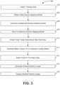
- FIG. 2 illustrates a method 200 for training a model that refines estimated parameter values within subsurface map data sets, in accordance with one or more implementations.
- the operations of method 200 presented below are intended to be illustrative. In some implementations, method 200 may be accomplished with one or more additional operations not described, and/or without one or more of the operations discussed. Additionally, the order in which the operations of method 200 are illustrated in FIG. 2 and described below is not intended to be limiting.
- Method 200 is implemented in one or more processing devices (e.g., a digital processor, a physical computer processor, an analog processor, a digital circuit designed to process information, an analog circuit designed to process information, a state machine, and/or other mechanisms for electronically processing information).
- the one or more processing devices may include one or more devices executing some or all of the operations of method 200 in response to instructions stored electronically on an electronic storage medium.
- the one or more processing devices may include one or more devices configured through hardware, firmware, and/or software to be specifically designed for execution of one or more of the operations of method 200.
- An operation 202 includes obtaining training data.
- the training data is obtained from electronic storage.
- the training data includes (i) unrefined subsurface map data sets specifying estimated parameter values of a first parameter as a function of position within corresponding subsurface volumes of interest and (ii) refined subsurface map data sets specifying refined estimations of parameter values of the first parameter as a function of position within the corresponding subsurface volumes of interest.
- the training data may include synthetic data pairs: subsurface map data specifying parameter values with noise introduced at several stages of the imaging process and noise-free parameter values, subsurface map data specifying parameter values that are filtered to have a lower sampling density and corresponding parameter values that have a higher sampling density than the filtered parameter values, and/or other data pairs.
- Unrefined subsurface map data sets include parameter values that have had noise introduced at several stages of the imaging process, parameter values that are filtered to have a lower sampling density, and/or other data.
- Refined subsurface map data sets include parameter values that have been denoised with respect to the parameter values corresponding to the unrefined subsurface map data, parameter values that have a higher sampling density than the parameter values corresponding to the unrefined subsurface map data, and/or other data.
- Operation 202 may be performed by one or more physical computer processors configured by machine-readable instructions including a module that is the same as or similar to training data obtaining module 108, in accordance with one or more implementations.
- An operation 204 may include obtaining an initial seismic mapping model.
- the initial seismic mapping model may be obtained from electronic storage.
- the initial seismic mapping model may include one or more of a convolutional neural network, a generative adversarial network and/or other machine learning systems.
- Operation 204 may be performed by one or more physical computer processors configured by machine-readable instructions including a module that is the same as or similar to mapping model obtaining module 112, in accordance with one or more implementations.
- An operation 206 includes generating a conditioned seismic mapping model.
- the conditioned seismic mapping model is generated by training the initial seismic mapping model.
- the conditioned seismic mapping model may be generated by one or more physical computer processors using the training data.
- the conditioned seismic mapping model may include one or more of a convolutional neural network, a generative adversarial network, and/or other machine learning systems.
- Operation 206 may be performed by one or more physical computer processors configured by machine-readable instructions including a module that is the same as or similar to mapping model generating module 114, in accordance with one or more implementations.
- An operation 208 may include storing the conditioned seismic mapping model.
- the conditioned seismic mapping model is stored in electronic storage.
- Operation 208 may be performed by one or more physical computer processors configured by machine-readable instructions including a module that is the same as or similar to mapping model storing module 116, in accordance with one or more implementations.
- An operation 210 includes obtaining an initial target subsurface map data set.
- the initial target subsurface map data set may include actual seismic data, AVA data, AVO data, seismic pre-stack data, seismic images, three-dimensional seismic maps, reservoir models, migrated data, stacked images, parameter values, and/or other data.
- Operation 210 may be performed by one or more physical computer processors configured by machine-readable instructions including a module that is the same as or similar to target obtaining module 110, in accordance with one or more implementations.
- An operation 212 includes generating a refined target subsurface map data set.
- the conditioned seismic mapping model is applied to the initial target subsurface map data set to generate the refined target subsurface map data set.
- the refined target subsurface map data set includes the data from an initial target subsurface map data set that has been processed by the conditioned seismic mapping model.
- the refined target subsurface map data set includes subsurface map data specifying noise-free parameter values, subsurface map data specifying parameter values that have a higher sampling density with respect to parameter values in the initial target subsurface map data set, and/or other data.
- Operation 212 may be performed by one or more physical computer processors configured by machine-readable instructions including a module that is the same as or similar to mapping model applying module 118, in accordance with one or more implementations.
- An operation 214 may include generating an image.
- the image may represent the refined target subsurface map data set using visual effects.
- Operation 214 may be performed by one or more physical computer processors configured by machine-readable instructions including a module that is the same as or similar to image generating module 122, in accordance with one or more implementations.
- An operation 216 may include displaying the image.
- the image may be displayed on a graphical user interface.
- Operation 216 may be performed by one or more physical computer processors configured by machine-readable instructions including a module that is the same as or similar to image display module 124, in accordance with one or more implementations.
- FIG. 3 illustrates a method 300 for training a model that refines estimated parameter values within subsurface map data sets, in accordance with one or more implementations.
- the operations of method 300 presented below are intended to be illustrative. In some implementations, method 300 may be accomplished with one or more additional operations not described, and/or without one or more of the operations discussed. Additionally, the order in which the operations of method 300 are illustrated in FIG. 3 and described below is not intended to be limiting.
- method 300 may be implemented in one or more processing devices (e.g., a digital processor, a physical computer processor, an analog processor, a digital circuit designed to process information, an analog circuit designed to process information, a state machine, and/or other mechanisms for electronically processing information).
- the one or more processing devices may include one or more devices executing some or all of the operations of method 300 in response to instructions stored electronically on an electronic storage medium.
- the one or more processing devices may include one or more devices configured through hardware, firmware, and/or software to be specifically designed for execution of one or more of the operations of method 300.
- An operation 302 may include obtaining training data.
- the training data may be obtained from electronic storage.
- the training data may include (i) unrefined subsurface map data sets specifying estimated parameter values of a first parameter as a function of position within corresponding subsurface volumes of interest and (ii) refined subsurface map data sets specifying refined estimations of parameter values of the first parameter as a function of position within the corresponding subsurface volumes of interest.
- the training data may include synthetic data pairs: subsurface map data specifying parameter values and corresponding indications of signal-to-noise ratio quality, and/or other data pairs.
- the unrefined subsurface map data sets may include subsurface map data and/or other data.
- the refined subsurface map data sets may include an indication of signal-to-noise ratio quality with respect to the parameter values corresponding to the unrefined subsurface map data and/or other data.
- Operation 302 may be performed by one or more physical computer processors configured by machine-readable instructions including a module that is the same as or similar to training data obtaining module 108, in accordance with one or more implementations.
- An operation 304 may include obtaining an initial seismic mapping model.
- the initial seismic mapping model may be obtained from electronic storage.
- the initial seismic mapping model may include one or more of a convolutional neural network and/or other machine learning systems.
- Operation 304 may be performed by one or more physical computer processors configured by machine-readable instructions including a module that is the same as or similar to mapping model obtaining module 112, in accordance with one or more implementations.
- An operation 306 may include generating a conditioned seismic mapping model.
- the conditioned seismic mapping model may be generated by training the initial seismic mapping model.
- the conditioned seismic mapping model may be generated by one or more physical computer processors using the training data.
- the conditioned seismic mapping model may include one or more of a convolutional neural network and/or other machine learning systems.
- Operation 306 may be performed by one or more physical computer processors configured by machine-readable instructions including a module that is the same as or similar to mapping model generating module 114, in accordance with one or more implementations.
- An operation 308 may include storing the conditioned seismic mapping model.
- the conditioned seismic mapping model may be stored in electronic storage.
- Operation 308 may be performed by one or more physical computer processors configured by machine-readable instructions including a module that is the same as or similar to mapping model storing module 116, in accordance with one or more implementations.
- An operation 310 may include obtaining initial target subsurface map data sets.
- the initial target subsurface map data set may have been derived from seismic pre-stack data and/or other data.
- Operation 310 may be performed by one or more physical computer processors configured by machine-readable instructions including a module that is the same as or similar to target obtaining module 110, in accordance with one or more implementations.
- An operation 312 may include generating metric values of an estimated quality metric.
- the metric values may be generated by applying the conditioned seismic mapping model individually to the initial target subsurface map data sets.
- An operation 314 may include selecting seismic pre-stack data.
- the seismic pre-stack data may be selected from among multiple sets of pre-stack data based on the metric values of the estimated quality metric.
- the selected seismic pre-stack data sets may be determined by whether a metric value corresponding to seismic pre-stack data exceeds a threshold value.
- Operation 314 may be performed by one or more physical computer processors configured by machine-readable instructions including a module that is the same as or similar to set selection module 120, in accordance with one or more implementations.
- An operation 316 may include generating a stacked seismic image.
- the stacked seismic image may be generated by using selected seismic pre-stack data sets.
- Operation 316 may be performed by one or more physical computer processors configured by machine-readable instructions including a module that is the same as or similar to image generating module 122, in accordance with one or more implementations.
- An operation 318 may include displaying the stacked seismic image.
- the stacked seismic image may be displayed on a graphical user interface.
- Operation 318 may be performed by one or more physical computer processors configured by machine-readable instructions including a module that is the same as or similar to image display module 124, in accordance with one or more implementations.
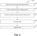
- FIG. 4 illustrates a method 400 for refining estimated parameter values within subsurface map data sets, in accordance with one or more implementations.
- the operations of method 400 presented below are intended to be illustrative. In some implementations, method 400 may be accomplished with one or more additional operations not described, and/or without one or more of the operations discussed. Additionally, the order in which the operations of method 400 are illustrated in FIG. 4 and described below is not intended to be limiting.
- Method 400 is implemented in one or more processing devices (e.g., a digital processor, an analog processor, a digital circuit designed to process information, an analog circuit designed to process information, a state machine, and/or other mechanisms for electronically processing information).
- the one or more processing devices includes one or more devices executing some or all of the operations of method 400 in response to instructions stored electronically on an electronic storage medium.
- the one or more processing devices may include one or more devices configured through hardware, firmware, and/or software to be specifically designed for execution of one or more of the operations of method 400.
- An operation 402 includes obtaining initial target subsurface map data sets.
- the initial target subsurface map data set may include actual seismic data, AVA data, AVO data, seismic pre-stack data, seismic images, three-dimensional seismic maps, reservoir models, migrated data, stacked images, parameter values, and/or other data.
- Operation 402 may be performed by one or more physical computer processors configured by machine-readable instructions including a module that is the same as or similar to target obtaining module 110, in accordance with one or more implementations.
- An operation 404 includes obtaining a conditioned seismic mapping model.
- the conditioned seismic mapping model may include one or more of a convolutional neural network, a generative adversarial network, and/or other machine learning systems.
- Operation 404 may be performed by one or more physical computer processors configured by machine-readable instructions including a module that is the same as or similar to mapping model obtaining module 112, in accordance with one or more implementations.
- An operation 406 includes generating a refined target subsurface map data set.
- the conditioned seismic mapping model is applied to the initial target subsurface map data set to generate the refined target subsurface map data set.
- the refined target subsurface map data set includes subsurface map data specifying noise-free parameter values, subsurface map data specifying parameter values that have a higher sampling density with respect to parameter values in the initial target subsurface map data set, and/or other data.
- Operation 406 may be performed by one or more physical computer processors configured by machine-readable instructions including a module that is the same as or similar to mapping model applying module 118, in accordance with one or more implementations.
- An operation 408 may include generating an image.
- the image may represent the refined target subsurface map data set using visual effects.
- Operation 408 may be performed by one or more physical computer processors configured by machine-readable instructions including a module that is the same as or similar to image generating module 122, in accordance with one or more implementations.
- An operation 410 may include displaying the image.
- the image may be displayed on a graphical user interface.
- Operation 408 may be performed by one or more physical computer processors configured by machine-readable instructions including a module that is the same as or similar to image display module 124, in accordance with one or more implementations.
- FIG. 5 illustrates a method 500 for refining estimated parameter values within subsurface map data sets, in accordance with one or more implementations.
- the operations of method 500 presented below are intended to be illustrative. In some implementations, method 500 may be accomplished with one or more additional operations not described, and/or without one or more of the operations discussed. Additionally, the order in which the operations of method 500 are illustrated in FIG. 5 and described below is not intended to be limiting.
- method 500 may be implemented in one or more processing devices (e.g., a digital processor, an analog processor, a digital circuit designed to process information, an analog circuit designed to process information, a state machine, and/or other mechanisms for electronically processing information).
- the one or more processing devices may include one or more devices executing some or all of the operations of method 500 in response to instructions stored electronically on an electronic storage medium.
- the one or more processing devices may include one or more devices configured through hardware, firmware, and/or software to be specifically designed for execution of one or more of the operations of method 500.
- An operation 502 may include obtaining initial target subsurface map data sets.
- the initial target subsurface map data set may have been derived from seismic pre-stack data and/or other data.
- Operation 502 may be performed by one or more physical computer processors configured by machine-readable instructions including a module that is the same as or similar to target obtaining module 110, in accordance with one or more implementations.
- An operation 504 may include obtaining a conditioned seismic mapping model.
- the conditioned seismic mapping model may include one or more of a convolutional neural network and/or other machine learning systems. Operation 504 may be performed by one or more physical computer processors configured by machine-readable instructions including a module that is the same as or similar to mapping model obtaining module 112, in accordance with one or more implementations.
- An operation 506 may include generating metric values of an estimated quality metric.
- the metric values may be generated by applying the conditioned seismic mapping model individually to the initial target subsurface map data sets.
- the estimated quality metric may include indications of signal-to-noise ratio quality. Operation 506 may be performed by one or more physical computer processors configured by machine-readable instructions including a module that is the same as or similar to mapping model applying module 118, in accordance with one or more implementations.
- An operation 508 may include selecting seismic pre-stack data.
- the seismic pre-stack data may be selected from among multiple sets of pre-stack data based on the metric values of the estimated quality metric.
- the selected seismic pre-stack data sets may be determined by whether a metric value corresponding to seismic pre-stack data exceeds a threshold value.
- Operation 506 may be performed by one or more physical computer processors configured by machine-readable instructions including a module that is the same as or similar to set selection module 120, in accordance with one or more implementations.
- An operation 510 may include generating a stacked seismic image.
- the stacked seismic image may be generated by using selected seismic pre-stack data sets.
- Operation 508 may be performed by one or more physical computer processors configured by machine-readable instructions including a module that is the same as or similar to image generating module 122, in accordance with one or more implementations.
- An operation 512 may include displaying the image.
- the image may be displayed on a graphical user interface.
- Operation 508 may be performed by one or more physical computer processors configured by machine-readable instructions including a module that is the same as or similar to image display module 124, in accordance with one or more implementations.
Landscapes
- Engineering & Computer Science (AREA)
- Remote Sensing (AREA)
- Physics & Mathematics (AREA)
- Life Sciences & Earth Sciences (AREA)
- Acoustics & Sound (AREA)
- Environmental & Geological Engineering (AREA)
- Geology (AREA)
- General Life Sciences & Earth Sciences (AREA)
- General Physics & Mathematics (AREA)
- Geophysics (AREA)
- Geophysics And Detection Of Objects (AREA)
- Management, Administration, Business Operations System, And Electronic Commerce (AREA)
- Testing Of Devices, Machine Parts, Or Other Structures Thereof (AREA)
Claims (9)
- Computerimplementiertes Verfahren (200; 400) zum Verfeinern geschätzter Parameterwerte in Untergrundkartendatensätzen, wobei das Verfahren (200; 400) in einem Computersystem (100) implementiert ist, das Computersystem (100) einen oder mehrere physische Computerprozessoren (130) und einen nichtflüchtigen elektronischen Speicher (128) enthält, der Untergrundkartendatensätze speichert, die verschiedenen Untergrundvolumina von Interesse entsprechen, wobei ein gegebener Untergrundkartendatensatz, der einem gegebenen Untergrundvolumen von Interesse entspricht, geschätzte Parameterwerte verschiedener Parameter als Abhängigkeit von der Position innerhalb des gegebenen Untergrundvolumens von Interesse spezifiziert, wobei das Verfahren (200; 400) umfasst:Ermitteln (210; 402) eines anfänglichen Ziel-Untergrundkartendatensatzes;Ermitteln (208; 404) eines aufbereiteten seismischen Kartierungsmodells aus dem elektronischen Speicher (128), wobei das aufbereitete seismische Kartierungsmodell durch Trainieren eines anfänglichen seismischen Kartierungsmodells unter Verwendung von Trainingsdaten aufbereitet (206) worden ist, wobei das anfängliche seismische Kartierungsmodell ein maschinelles Lernmodell ist und wobei die Trainingsdaten (i) unverfeinerte Untergrundkartendatensätze, die geschätzte Parameterwerte eines ersten Parameters als Abhängigkeit von der Position innerhalb entsprechender Untergrundvolumina von Interesse spezifizieren, und (ii) verfeinerte Untergrundkartendatensätze enthalten, die verfeinerte Schätzungen von Parameterwerten des ersten Parameters als Abhängigkeit von der Position innerhalb der entsprechenden interessierenden Untergrundvolumina festlegen; undAnwenden (212; 406) des aufbereiteten seismischen Kartierungsmodells auf den anfänglichen Ziel-Untergrundkartendatensatz, um einen verfeinerten Ziel-Untergrundkartendatensatz zu erzeugen,wobei:die Trainingsdaten Datenpaare von Untergrundkartendaten umfassen, wobei die unverfeinerten Untergrundkartendatensätze Parameterwerte enthalten, die so gefiltert sind, dass sie eine niedrigere Abtastdichte aufweisen, und die verfeinerten Untergrundkartendatensätze entsprechende Parameterwerte enthalten, die eine höhere Abtastdichte als die gefilterten Parameterwerte aufweisen, und eine Abtastdichte von Parameterwerten innerhalb des Untergrundvolumens von Interesse für den verfeinerten Ziel-Untergrundkartendatensatz höher als für den ursprünglichen Ziel-Untergrundkartendatensatz ist; und/oderdie Trainingsdaten Datenpaare von Untergrundkartendaten umfassen, wobei die unverfeinerten Untergrundkartendatensätze Parameterwerte mit eingeführtem Rauschen enthalten und die verfeinerten Untergrundkartendatensätze entsprechende rauschfreie Parameterwerte enthalten, und die Parameterwerte in dem verfeinerten Ziel-Untergrundkartendatensatz in Bezug auf Parameterwerte in dem anfänglichen Ziel-Untergrundkartendatensatz entrauscht wurden.
- Computerimplementiertes Verfahren nach Anspruch 1, umfassend:Erzeugen (214; 408) eines Bildes, das den verfeinerten Ziel-Untergrundkartendatensatz unter Verwendung visueller Effekte darstellt, um mindestens einen Teil der Parameterwerte in dem verfeinerten Ziel-Untergrundkartendatensatz als Abhängigkeit von der Position innerhalb des Untergrundvolumens von Interesse darzustellen; und optionalAnzeigen (216; 410) des Bildes auf einer grafischen Benutzeroberfläche.
- Computerimplementiertes Verfahren nach Anspruch 1 oder 2, umfassend:Abrufen (202) der Trainingsdaten aus dem elektronischen Speicher (128);Abrufen (204) des anfänglichen seismischen Kartierungsmodells aus dem elektronischen Speicher (128) ;Erzeugen (206) des aufbereiteten seismischen Kartierungsmodells durch Trainieren des anfänglichen seismischen Kartierungsmodells auf dem einen oder den mehreren physischen Computerprozessoren (130) unter Verwendung der Trainingsdaten; undSpeichern (208) des aufbereiteten seismischen Kartierungsmodells in dem elektronischen Speicher (128).
- Computerimplementiertes Verfahren nach einem der vorhergehenden Ansprüche, wobei die Trainingsdaten synthetische Daten umfassen.
- Computerimplementiertes Verfahren nach einem der vorhergehenden Ansprüche, wobei der anfängliche Ziel-Untergrundkartendatensatz tatsächliche Untergrundkartendaten umfasst.
- Computerimplementiertes Verfahren nach einem der vorhergehenden Ansprüche, wobei das anfängliche seismische Kartierungsmodell und das aufbereitete seismische Kartierungsmodell ein faltendes neuronales Netz umfassen.
- Computersystem (100), umfassend einen oder mehrere physische Computerprozessoren (130) und einen nichtflüchtigen elektronischen Speicher (128), der Untergrundkartendatensätze speichert, die verschiedenen Untergrundvolumina von Interesse entsprechen, wobei ein gegebener Untergrundkartendatensatz, der einem gegebenen Untergrundvolumen von Interesse entspricht, geschätzte Parameterwerte verschiedener Parameter als Abhängigkeit von der Position innerhalb des gegebenen Untergrundvolumens von Interesse festlegt, wobei das Computersystem (100) dazu ausgelegt ist, das Verfahren nach einem der vorhergehenden Ansprüche auszuführen.
- Computerprogramm, das beim Ausführen auf einem Computersystem (100), das einen oder mehrere physische Computerprozessoren (130) und einen nichtflüchtigen elektronischen Speicher (128) umfasst, der Untergrundkartendatensätze speichert, die verschiedenen Untergrundvolumina von Interesse entsprechen, wobei ein gegebener Untergrundkartendatensatz, der einem gegebenen Untergrundvolumen von Interesse entspricht, geschätzte Parameterwerte verschiedener Parameter als Abhängigkeit von der Position innerhalb des gegebenen Untergrundvolumens von Interesse festlegt, das Computersystem (100) dazu veranlasst, das Verfahren nach einem der Ansprüche 1 bis 6 auszuführen.
- Elektronischer Speicher, auf dem das Computerprogramm nach Anspruch 8 gespeichert ist.
Priority Applications (1)
| Application Number | Priority Date | Filing Date | Title |
|---|---|---|---|
| EP24196805.6A EP4446782A3 (de) | 2017-12-06 | 2018-10-16 | Systeme und verfahren zur verfeinerung von geschätzten parameterwerten in der seismischen bildgebung |
Applications Claiming Priority (2)
| Application Number | Priority Date | Filing Date | Title |
|---|---|---|---|
| US15/833,203 US11231513B2 (en) | 2017-12-06 | 2017-12-06 | Systems and methods for refining estimated parameter values in seismic imaging |
| PCT/IB2018/057996 WO2019111070A2 (en) | 2017-12-06 | 2018-10-16 | Systems and methods for refining estimated parameter values in seismic imaging |
Related Child Applications (2)
| Application Number | Title | Priority Date | Filing Date |
|---|---|---|---|
| EP24196805.6A Division EP4446782A3 (de) | 2017-12-06 | 2018-10-16 | Systeme und verfahren zur verfeinerung von geschätzten parameterwerten in der seismischen bildgebung |
| EP24196805.6A Division-Into EP4446782A3 (de) | 2017-12-06 | 2018-10-16 | Systeme und verfahren zur verfeinerung von geschätzten parameterwerten in der seismischen bildgebung |
Publications (2)
| Publication Number | Publication Date |
|---|---|
| EP3721265A2 EP3721265A2 (de) | 2020-10-14 |
| EP3721265B1 true EP3721265B1 (de) | 2024-10-09 |
Family
ID=64109964
Family Applications (2)
| Application Number | Title | Priority Date | Filing Date |
|---|---|---|---|
| EP24196805.6A Pending EP4446782A3 (de) | 2017-12-06 | 2018-10-16 | Systeme und verfahren zur verfeinerung von geschätzten parameterwerten in der seismischen bildgebung |
| EP18797136.1A Active EP3721265B1 (de) | 2017-12-06 | 2018-10-16 | Systeme und verfahren zur verfeinerung von geschätzten parameterwerten in der seismischen bildgebung |
Family Applications Before (1)
| Application Number | Title | Priority Date | Filing Date |
|---|---|---|---|
| EP24196805.6A Pending EP4446782A3 (de) | 2017-12-06 | 2018-10-16 | Systeme und verfahren zur verfeinerung von geschätzten parameterwerten in der seismischen bildgebung |
Country Status (4)
| Country | Link |
|---|---|
| US (1) | US11231513B2 (de) |
| EP (2) | EP4446782A3 (de) |
| AU (1) | AU2018379824B2 (de) |
| WO (1) | WO2019111070A2 (de) |
Families Citing this family (9)
| Publication number | Priority date | Publication date | Assignee | Title |
|---|---|---|---|---|
| US11803678B2 (en) * | 2018-04-12 | 2023-10-31 | Schlumberger Technology Corporation | Disentanglement for inference on seismic data and generation of seismic data |
| CN110361778B (zh) * | 2019-07-04 | 2020-10-13 | 华北电力大学 | 一种基于生成对抗网络的地震数据重建方法 |
| EP4025937B1 (de) | 2019-09-03 | 2024-01-10 | Chevron U.S.A. Inc. | System und verfahren zur seismischen abbildung von unterirdischen volumen mit komplexer geologie |
| US11733424B2 (en) | 2020-07-31 | 2023-08-22 | Chevron U.S.A. Inc. | Systems and methods for identifying subsurface features as functions of feature positions in a subsurface volume of interest |
| US11841479B2 (en) * | 2020-07-31 | 2023-12-12 | Chevron U.S.A. Inc. | Systems and methods for identifying subsurface features as a function of position in a subsurface volume of interest |
| US12481079B2 (en) * | 2020-09-22 | 2025-11-25 | Chevron U.S.A. Inc. | Systems and methods for generating elastic property data as a function of position and time in a subsurface volume of interest |
| US11953636B2 (en) | 2022-03-04 | 2024-04-09 | Fleet Space Technologies Pty Ltd | Satellite-enabled node for ambient noise tomography |
| CN114624773A (zh) * | 2022-04-29 | 2022-06-14 | 成都理工大学 | 一种确定致密储层含气性的方法及装置 |
| CN115980840A (zh) * | 2022-11-24 | 2023-04-18 | 中国石油大学(华东) | 地震数据去噪的模型训练方法、地震数据去噪方法及装置 |
Family Cites Families (4)
| Publication number | Priority date | Publication date | Assignee | Title |
|---|---|---|---|---|
| DE19943325C2 (de) * | 1999-09-10 | 2001-12-13 | Trappe Henning | Verfahren zur Bearbeitung seismischer Meßdaten mit einem neuronalen Netzwerk |
| US6560540B2 (en) * | 2000-09-29 | 2003-05-06 | Exxonmobil Upstream Research Company | Method for mapping seismic attributes using neural networks |
| SG11201501141UA (en) * | 2012-12-05 | 2015-03-30 | Landmark Graphics Corp | Systems and methods for 3d seismic data depth conversion utilizing artificial neural networks |
| US9310500B2 (en) * | 2013-02-20 | 2016-04-12 | Chevron U.S.A. Inc. | Velocity models for processing seismic data based on basin modeling |
-
2017
- 2017-12-06 US US15/833,203 patent/US11231513B2/en active Active
-
2018
- 2018-10-16 EP EP24196805.6A patent/EP4446782A3/de active Pending
- 2018-10-16 WO PCT/IB2018/057996 patent/WO2019111070A2/en not_active Ceased
- 2018-10-16 EP EP18797136.1A patent/EP3721265B1/de active Active
- 2018-10-16 AU AU2018379824A patent/AU2018379824B2/en active Active
Non-Patent Citations (1)
| Title |
|---|
| CHAO DONG ET AL: "Image Super-Resolution Using Deep Convolutional Networks", IEEE TRANSACTIONS ON PATTERN ANALYSIS AND MACHINE INTELLIGENCE, vol. 38, no. 2, 1 February 2016 (2016-02-01), USA, pages 295 - 307, XP055539754, ISSN: 0162-8828, DOI: 10.1109/TPAMI.2015.2439281 * |
Also Published As
| Publication number | Publication date |
|---|---|
| AU2018379824A1 (en) | 2020-03-12 |
| EP4446782A3 (de) | 2025-01-08 |
| US20190170888A1 (en) | 2019-06-06 |
| EP4446782A2 (de) | 2024-10-16 |
| WO2019111070A2 (en) | 2019-06-13 |
| EP3721265A2 (de) | 2020-10-14 |
| US11231513B2 (en) | 2022-01-25 |
| WO2019111070A3 (en) | 2019-11-21 |
| AU2018379824B2 (en) | 2022-12-08 |
Similar Documents
| Publication | Publication Date | Title |
|---|---|---|
| AU2018379824B2 (en) | Systems and methods for refining estimated parameter values in seismic imaging | |
| AU2019248523B2 (en) | Systems and methods for using probabilities of lithologies in an inversion | |
| CA2940406C (en) | Characterizing a physical structure using a multidimensional noise model to attenuate noise data | |
| CN110050205B (zh) | 使用偏移道集的潜波照明 | |
| CN113015926A (zh) | 无源地震成像 | |
| WO2015199759A1 (en) | Instantaneous isochron attribute-based geobody identification for reservoir modeling | |
| US10598807B2 (en) | Correction of sea surface state | |
| EP2743734A2 (de) | Zielgerichtetes 4D-Binning in gemeinsamem Reflexionspunkt | |
| CN109154674A (zh) | 利用光流确定在地震图像之间的位移 | |
| EP3776010B1 (de) | Systeme und verfahren zur verfeinerung von geschätzten wirkungen von parametern auf amplituden | |
| US11080525B1 (en) | Methods of identifying flying objects using digital imaging | |
| EP2743737A2 (de) | Verfahren und Systeme zur Qualitätskontrolle seismischer Beleuchtungskarten | |
| US20160047927A1 (en) | Determination of an impulse response at a subsurface image level | |
| US20190146108A1 (en) | System and method for assessing the presence of hydrocarbons in a subterranean reservoir based on seismic data | |
| CN120020601A (zh) | 有机质含量预测方法、装置、设备及存储介质 |
Legal Events
| Date | Code | Title | Description |
|---|---|---|---|
| STAA | Information on the status of an ep patent application or granted ep patent |
Free format text: STATUS: UNKNOWN |
|
| STAA | Information on the status of an ep patent application or granted ep patent |
Free format text: STATUS: THE INTERNATIONAL PUBLICATION HAS BEEN MADE |
|
| PUAI | Public reference made under article 153(3) epc to a published international application that has entered the european phase |
Free format text: ORIGINAL CODE: 0009012 |
|
| STAA | Information on the status of an ep patent application or granted ep patent |
Free format text: STATUS: REQUEST FOR EXAMINATION WAS MADE |
|
| 17P | Request for examination filed |
Effective date: 20200224 |
|
| AK | Designated contracting states |
Kind code of ref document: A2 Designated state(s): AL AT BE BG CH CY CZ DE DK EE ES FI FR GB GR HR HU IE IS IT LI LT LU LV MC MK MT NL NO PL PT RO RS SE SI SK SM TR |
|
| AX | Request for extension of the european patent |
Extension state: BA ME |
|
| RIN1 | Information on inventor provided before grant (corrected) |
Inventor name: CHENG, SHUXING Inventor name: BANDURA, LAURA L. Inventor name: OSYPOV, KONSTANTIN Inventor name: HALPERT, ADAM DEAN |
|
| DAV | Request for validation of the european patent (deleted) | ||
| DAX | Request for extension of the european patent (deleted) | ||
| STAA | Information on the status of an ep patent application or granted ep patent |
Free format text: STATUS: EXAMINATION IS IN PROGRESS |
|
| 17Q | First examination report despatched |
Effective date: 20220811 |
|
| P01 | Opt-out of the competence of the unified patent court (upc) registered |
Effective date: 20230522 |
|
| GRAP | Despatch of communication of intention to grant a patent |
Free format text: ORIGINAL CODE: EPIDOSNIGR1 |
|
| STAA | Information on the status of an ep patent application or granted ep patent |
Free format text: STATUS: GRANT OF PATENT IS INTENDED |
|
| RIC1 | Information provided on ipc code assigned before grant |
Ipc: G01V 1/36 20060101ALI20240313BHEP Ipc: G01V 1/30 20060101ALI20240313BHEP Ipc: G01V 1/28 20060101AFI20240313BHEP |
|
| GRAJ | Information related to disapproval of communication of intention to grant by the applicant or resumption of examination proceedings by the epo deleted |
Free format text: ORIGINAL CODE: EPIDOSDIGR1 |
|
| INTG | Intention to grant announced |
Effective date: 20240328 |
|
| STAA | Information on the status of an ep patent application or granted ep patent |
Free format text: STATUS: EXAMINATION IS IN PROGRESS |
|
| GRAP | Despatch of communication of intention to grant a patent |
Free format text: ORIGINAL CODE: EPIDOSNIGR1 |
|
| STAA | Information on the status of an ep patent application or granted ep patent |
Free format text: STATUS: GRANT OF PATENT IS INTENDED |
|
| INTC | Intention to grant announced (deleted) | ||
| INTG | Intention to grant announced |
Effective date: 20240508 |
|
| RAP3 | Party data changed (applicant data changed or rights of an application transferred) |
Owner name: CHEVRON U.S.A. INC. |
|
| GRAS | Grant fee paid |
Free format text: ORIGINAL CODE: EPIDOSNIGR3 |
|
| GRAA | (expected) grant |
Free format text: ORIGINAL CODE: 0009210 |
|
| STAA | Information on the status of an ep patent application or granted ep patent |
Free format text: STATUS: THE PATENT HAS BEEN GRANTED |
|
| AK | Designated contracting states |
Kind code of ref document: B1 Designated state(s): AL AT BE BG CH CY CZ DE DK EE ES FI FR GB GR HR HU IE IS IT LI LT LU LV MC MK MT NL NO PL PT RO RS SE SI SK SM TR |
|
| REG | Reference to a national code |
Ref country code: CH Ref legal event code: EP |
|
| REG | Reference to a national code |
Ref country code: NL Ref legal event code: FP |
|
| REG | Reference to a national code |
Ref country code: DE Ref legal event code: R096 Ref document number: 602018075246 Country of ref document: DE |
|
| REG | Reference to a national code |
Ref country code: IE Ref legal event code: FG4D |
|
| PGFP | Annual fee paid to national office [announced via postgrant information from national office to epo] |
Ref country code: DE Payment date: 20241008 Year of fee payment: 7 |
|
| REG | Reference to a national code |
Ref country code: LT Ref legal event code: MG9D |
|
| REG | Reference to a national code |
Ref country code: AT Ref legal event code: MK05 Ref document number: 1731151 Country of ref document: AT Kind code of ref document: T Effective date: 20241009 |
|
| PG25 | Lapsed in a contracting state [announced via postgrant information from national office to epo] |
Ref country code: HR Free format text: LAPSE BECAUSE OF FAILURE TO SUBMIT A TRANSLATION OF THE DESCRIPTION OR TO PAY THE FEE WITHIN THE PRESCRIBED TIME-LIMIT Effective date: 20241009 Ref country code: IS Free format text: LAPSE BECAUSE OF FAILURE TO SUBMIT A TRANSLATION OF THE DESCRIPTION OR TO PAY THE FEE WITHIN THE PRESCRIBED TIME-LIMIT Effective date: 20250209 Ref country code: PT Free format text: LAPSE BECAUSE OF FAILURE TO SUBMIT A TRANSLATION OF THE DESCRIPTION OR TO PAY THE FEE WITHIN THE PRESCRIBED TIME-LIMIT Effective date: 20250210 |
|
| PG25 | Lapsed in a contracting state [announced via postgrant information from national office to epo] |
Ref country code: FI Free format text: LAPSE BECAUSE OF FAILURE TO SUBMIT A TRANSLATION OF THE DESCRIPTION OR TO PAY THE FEE WITHIN THE PRESCRIBED TIME-LIMIT Effective date: 20241009 |
|
| PG25 | Lapsed in a contracting state [announced via postgrant information from national office to epo] |
Ref country code: BG Free format text: LAPSE BECAUSE OF FAILURE TO SUBMIT A TRANSLATION OF THE DESCRIPTION OR TO PAY THE FEE WITHIN THE PRESCRIBED TIME-LIMIT Effective date: 20241009 |
|
| PG25 | Lapsed in a contracting state [announced via postgrant information from national office to epo] |
Ref country code: ES Free format text: LAPSE BECAUSE OF FAILURE TO SUBMIT A TRANSLATION OF THE DESCRIPTION OR TO PAY THE FEE WITHIN THE PRESCRIBED TIME-LIMIT Effective date: 20241009 |
|
| PG25 | Lapsed in a contracting state [announced via postgrant information from national office to epo] |
Ref country code: LV Free format text: LAPSE BECAUSE OF FAILURE TO SUBMIT A TRANSLATION OF THE DESCRIPTION OR TO PAY THE FEE WITHIN THE PRESCRIBED TIME-LIMIT Effective date: 20241009 Ref country code: GR Free format text: LAPSE BECAUSE OF FAILURE TO SUBMIT A TRANSLATION OF THE DESCRIPTION OR TO PAY THE FEE WITHIN THE PRESCRIBED TIME-LIMIT Effective date: 20250110 Ref country code: AT Free format text: LAPSE BECAUSE OF FAILURE TO SUBMIT A TRANSLATION OF THE DESCRIPTION OR TO PAY THE FEE WITHIN THE PRESCRIBED TIME-LIMIT Effective date: 20241009 |
|
| PG25 | Lapsed in a contracting state [announced via postgrant information from national office to epo] |
Ref country code: PL Free format text: LAPSE BECAUSE OF FAILURE TO SUBMIT A TRANSLATION OF THE DESCRIPTION OR TO PAY THE FEE WITHIN THE PRESCRIBED TIME-LIMIT Effective date: 20241009 |
|
| PG25 | Lapsed in a contracting state [announced via postgrant information from national office to epo] |
Ref country code: RS Free format text: LAPSE BECAUSE OF FAILURE TO SUBMIT A TRANSLATION OF THE DESCRIPTION OR TO PAY THE FEE WITHIN THE PRESCRIBED TIME-LIMIT Effective date: 20250109 |
|
| REG | Reference to a national code |
Ref country code: CH Ref legal event code: PL |
|
| PG25 | Lapsed in a contracting state [announced via postgrant information from national office to epo] |
Ref country code: SM Free format text: LAPSE BECAUSE OF FAILURE TO SUBMIT A TRANSLATION OF THE DESCRIPTION OR TO PAY THE FEE WITHIN THE PRESCRIBED TIME-LIMIT Effective date: 20241009 |
|
| PG25 | Lapsed in a contracting state [announced via postgrant information from national office to epo] |
Ref country code: MC Free format text: LAPSE BECAUSE OF FAILURE TO SUBMIT A TRANSLATION OF THE DESCRIPTION OR TO PAY THE FEE WITHIN THE PRESCRIBED TIME-LIMIT Effective date: 20241009 |
|
| PG25 | Lapsed in a contracting state [announced via postgrant information from national office to epo] |
Ref country code: DK Free format text: LAPSE BECAUSE OF FAILURE TO SUBMIT A TRANSLATION OF THE DESCRIPTION OR TO PAY THE FEE WITHIN THE PRESCRIBED TIME-LIMIT Effective date: 20241009 |
|
| REG | Reference to a national code |
Ref country code: DE Ref legal event code: R097 Ref document number: 602018075246 Country of ref document: DE |
|
| PG25 | Lapsed in a contracting state [announced via postgrant information from national office to epo] |
Ref country code: BE Free format text: LAPSE BECAUSE OF NON-PAYMENT OF DUE FEES Effective date: 20241031 Ref country code: LU Free format text: LAPSE BECAUSE OF NON-PAYMENT OF DUE FEES Effective date: 20241016 |
|
| PG25 | Lapsed in a contracting state [announced via postgrant information from national office to epo] |
Ref country code: EE Free format text: LAPSE BECAUSE OF FAILURE TO SUBMIT A TRANSLATION OF THE DESCRIPTION OR TO PAY THE FEE WITHIN THE PRESCRIBED TIME-LIMIT Effective date: 20241009 |
|
| PG25 | Lapsed in a contracting state [announced via postgrant information from national office to epo] |
Ref country code: CH Free format text: LAPSE BECAUSE OF NON-PAYMENT OF DUE FEES Effective date: 20241031 |
|
| PG25 | Lapsed in a contracting state [announced via postgrant information from national office to epo] |
Ref country code: RO Free format text: LAPSE BECAUSE OF FAILURE TO SUBMIT A TRANSLATION OF THE DESCRIPTION OR TO PAY THE FEE WITHIN THE PRESCRIBED TIME-LIMIT Effective date: 20241009 |
|
| PG25 | Lapsed in a contracting state [announced via postgrant information from national office to epo] |
Ref country code: SK Free format text: LAPSE BECAUSE OF FAILURE TO SUBMIT A TRANSLATION OF THE DESCRIPTION OR TO PAY THE FEE WITHIN THE PRESCRIBED TIME-LIMIT Effective date: 20241009 |
|
| PG25 | Lapsed in a contracting state [announced via postgrant information from national office to epo] |
Ref country code: CZ Free format text: LAPSE BECAUSE OF FAILURE TO SUBMIT A TRANSLATION OF THE DESCRIPTION OR TO PAY THE FEE WITHIN THE PRESCRIBED TIME-LIMIT Effective date: 20241009 |
|
| PG25 | Lapsed in a contracting state [announced via postgrant information from national office to epo] |
Ref country code: IT Free format text: LAPSE BECAUSE OF FAILURE TO SUBMIT A TRANSLATION OF THE DESCRIPTION OR TO PAY THE FEE WITHIN THE PRESCRIBED TIME-LIMIT Effective date: 20241009 |
|
| REG | Reference to a national code |
Ref country code: BE Ref legal event code: MM Effective date: 20241031 |
|
| PLBE | No opposition filed within time limit |
Free format text: ORIGINAL CODE: 0009261 |
|
| STAA | Information on the status of an ep patent application or granted ep patent |
Free format text: STATUS: NO OPPOSITION FILED WITHIN TIME LIMIT |
|
| PG25 | Lapsed in a contracting state [announced via postgrant information from national office to epo] |
Ref country code: SE Free format text: LAPSE BECAUSE OF FAILURE TO SUBMIT A TRANSLATION OF THE DESCRIPTION OR TO PAY THE FEE WITHIN THE PRESCRIBED TIME-LIMIT Effective date: 20241009 |
|
| 26N | No opposition filed |
Effective date: 20250710 |
|
| PGFP | Annual fee paid to national office [announced via postgrant information from national office to epo] |
Ref country code: NL Payment date: 20250912 Year of fee payment: 8 |
|
| PGFP | Annual fee paid to national office [announced via postgrant information from national office to epo] |
Ref country code: GB Payment date: 20250904 Year of fee payment: 8 |
|
| PGFP | Annual fee paid to national office [announced via postgrant information from national office to epo] |
Ref country code: FR Payment date: 20250908 Year of fee payment: 8 |
|
| PG25 | Lapsed in a contracting state [announced via postgrant information from national office to epo] |
Ref country code: IE Free format text: LAPSE BECAUSE OF NON-PAYMENT OF DUE FEES Effective date: 20241016 |
|
| PGFP | Annual fee paid to national office [announced via postgrant information from national office to epo] |
Ref country code: NO Payment date: 20251009 Year of fee payment: 8 |
|
| PG25 | Lapsed in a contracting state [announced via postgrant information from national office to epo] |
Ref country code: CY Free format text: LAPSE BECAUSE OF FAILURE TO SUBMIT A TRANSLATION OF THE DESCRIPTION OR TO PAY THE FEE WITHIN THE PRESCRIBED TIME-LIMIT; INVALID AB INITIO Effective date: 20181016 |
|
| PG25 | Lapsed in a contracting state [announced via postgrant information from national office to epo] |
Ref country code: HU Free format text: LAPSE BECAUSE OF FAILURE TO SUBMIT A TRANSLATION OF THE DESCRIPTION OR TO PAY THE FEE WITHIN THE PRESCRIBED TIME-LIMIT; INVALID AB INITIO Effective date: 20181016 |