EP3657217B1 - Erfassungs- und modellierungsverfahren eines umgebungswindfelds durch einen lidar-sensor - Google Patents
Erfassungs- und modellierungsverfahren eines umgebungswindfelds durch einen lidar-sensor Download PDFInfo
- Publication number
- EP3657217B1 EP3657217B1 EP19206135.6A EP19206135A EP3657217B1 EP 3657217 B1 EP3657217 B1 EP 3657217B1 EP 19206135 A EP19206135 A EP 19206135A EP 3657217 B1 EP3657217 B1 EP 3657217B1
- Authority
- EP
- European Patent Office
- Prior art keywords
- wind
- measurement
- points
- lidar sensor
- lidar
- Prior art date
- Legal status (The legal status is an assumption and is not a legal conclusion. Google has not performed a legal analysis and makes no representation as to the accuracy of the status listed.)
- Active
Links
Images



Classifications
-
- G—PHYSICS
- G01—MEASURING; TESTING
- G01S—RADIO DIRECTION-FINDING; RADIO NAVIGATION; DETERMINING DISTANCE OR VELOCITY BY USE OF RADIO WAVES; LOCATING OR PRESENCE-DETECTING BY USE OF THE REFLECTION OR RERADIATION OF RADIO WAVES; ANALOGOUS ARRANGEMENTS USING OTHER WAVES
- G01S17/00—Systems using the reflection or reradiation of electromagnetic waves other than radio waves, e.g. lidar systems
- G01S17/02—Systems using the reflection of electromagnetic waves other than radio waves
- G01S17/50—Systems of measurement based on relative movement of target
- G01S17/58—Velocity or trajectory determination systems; Sense-of-movement determination systems
-
- G—PHYSICS
- G01—MEASURING; TESTING
- G01S—RADIO DIRECTION-FINDING; RADIO NAVIGATION; DETERMINING DISTANCE OR VELOCITY BY USE OF RADIO WAVES; LOCATING OR PRESENCE-DETECTING BY USE OF THE REFLECTION OR RERADIATION OF RADIO WAVES; ANALOGOUS ARRANGEMENTS USING OTHER WAVES
- G01S17/00—Systems using the reflection or reradiation of electromagnetic waves other than radio waves, e.g. lidar systems
- G01S17/88—Lidar systems specially adapted for specific applications
- G01S17/95—Lidar systems specially adapted for specific applications for meteorological use
-
- F—MECHANICAL ENGINEERING; LIGHTING; HEATING; WEAPONS; BLASTING
- F03—MACHINES OR ENGINES FOR LIQUIDS; WIND, SPRING, OR WEIGHT MOTORS; PRODUCING MECHANICAL POWER OR A REACTIVE PROPULSIVE THRUST, NOT OTHERWISE PROVIDED FOR
- F03D—WIND MOTORS
- F03D17/00—Monitoring or testing of wind motors, e.g. diagnostics
-
- F—MECHANICAL ENGINEERING; LIGHTING; HEATING; WEAPONS; BLASTING
- F03—MACHINES OR ENGINES FOR LIQUIDS; WIND, SPRING, OR WEIGHT MOTORS; PRODUCING MECHANICAL POWER OR A REACTIVE PROPULSIVE THRUST, NOT OTHERWISE PROVIDED FOR
- F03D—WIND MOTORS
- F03D7/00—Controlling wind motors
- F03D7/02—Controlling wind motors the wind motors having rotation axis substantially parallel to the air flow entering the rotor
- F03D7/04—Automatic control; Regulation
- F03D7/042—Automatic control; Regulation by means of an electrical or electronic controller
-
- G—PHYSICS
- G01—MEASURING; TESTING
- G01P—MEASURING LINEAR OR ANGULAR SPEED, ACCELERATION, DECELERATION, OR SHOCK; INDICATING PRESENCE, ABSENCE, OR DIRECTION, OF MOVEMENT
- G01P5/00—Measuring speed of fluids, e.g. of air stream; Measuring speed of bodies relative to fluids, e.g. of ship, of aircraft
- G01P5/26—Measuring speed of fluids, e.g. of air stream; Measuring speed of bodies relative to fluids, e.g. of ship, of aircraft by measuring the direct influence of the streaming fluid on the properties of a detecting optical wave
-
- G—PHYSICS
- G01—MEASURING; TESTING
- G01S—RADIO DIRECTION-FINDING; RADIO NAVIGATION; DETERMINING DISTANCE OR VELOCITY BY USE OF RADIO WAVES; LOCATING OR PRESENCE-DETECTING BY USE OF THE REFLECTION OR RERADIATION OF RADIO WAVES; ANALOGOUS ARRANGEMENTS USING OTHER WAVES
- G01S7/00—Details of systems according to groups G01S13/00, G01S15/00, G01S17/00
- G01S7/48—Details of systems according to groups G01S13/00, G01S15/00, G01S17/00 of systems according to group G01S17/00
- G01S7/4808—Evaluating distance, position or velocity data
-
- G—PHYSICS
- G06—COMPUTING OR CALCULATING; COUNTING
- G06F—ELECTRIC DIGITAL DATA PROCESSING
- G06F17/00—Digital computing or data processing equipment or methods, specially adapted for specific functions
- G06F17/10—Complex mathematical operations
- G06F17/16—Matrix or vector computation, e.g. matrix-matrix or matrix-vector multiplication, matrix factorization
-
- G—PHYSICS
- G06—COMPUTING OR CALCULATING; COUNTING
- G06F—ELECTRIC DIGITAL DATA PROCESSING
- G06F17/00—Digital computing or data processing equipment or methods, specially adapted for specific functions
- G06F17/10—Complex mathematical operations
- G06F17/17—Function evaluation by approximation methods, e.g. inter- or extrapolation, smoothing, least mean square method
-
- F—MECHANICAL ENGINEERING; LIGHTING; HEATING; WEAPONS; BLASTING
- F05—INDEXING SCHEMES RELATING TO ENGINES OR PUMPS IN VARIOUS SUBCLASSES OF CLASSES F01-F04
- F05B—INDEXING SCHEME RELATING TO WIND, SPRING, WEIGHT, INERTIA OR LIKE MOTORS, TO MACHINES OR ENGINES FOR LIQUIDS COVERED BY SUBCLASSES F03B, F03D AND F03G
- F05B2270/00—Control
- F05B2270/30—Control parameters, e.g. input parameters
- F05B2270/328—Blade pitch angle
-
- F—MECHANICAL ENGINEERING; LIGHTING; HEATING; WEAPONS; BLASTING
- F05—INDEXING SCHEMES RELATING TO ENGINES OR PUMPS IN VARIOUS SUBCLASSES OF CLASSES F01-F04
- F05B—INDEXING SCHEME RELATING TO WIND, SPRING, WEIGHT, INERTIA OR LIKE MOTORS, TO MACHINES OR ENGINES FOR LIQUIDS COVERED BY SUBCLASSES F03B, F03D AND F03G
- F05B2270/00—Control
- F05B2270/30—Control parameters, e.g. input parameters
- F05B2270/329—Azimuth or yaw angle
-
- F—MECHANICAL ENGINEERING; LIGHTING; HEATING; WEAPONS; BLASTING
- F05—INDEXING SCHEMES RELATING TO ENGINES OR PUMPS IN VARIOUS SUBCLASSES OF CLASSES F01-F04
- F05B—INDEXING SCHEME RELATING TO WIND, SPRING, WEIGHT, INERTIA OR LIKE MOTORS, TO MACHINES OR ENGINES FOR LIQUIDS COVERED BY SUBCLASSES F03B, F03D AND F03G
- F05B2270/00—Control
- F05B2270/80—Devices generating input signals, e.g. transducers, sensors, cameras or strain gauges
- F05B2270/804—Optical devices
- F05B2270/8042—Lidar systems
-
- Y—GENERAL TAGGING OF NEW TECHNOLOGICAL DEVELOPMENTS; GENERAL TAGGING OF CROSS-SECTIONAL TECHNOLOGIES SPANNING OVER SEVERAL SECTIONS OF THE IPC; TECHNICAL SUBJECTS COVERED BY FORMER USPC CROSS-REFERENCE ART COLLECTIONS [XRACs] AND DIGESTS
- Y02—TECHNOLOGIES OR APPLICATIONS FOR MITIGATION OR ADAPTATION AGAINST CLIMATE CHANGE
- Y02A—TECHNOLOGIES FOR ADAPTATION TO CLIMATE CHANGE
- Y02A90/00—Technologies having an indirect contribution to adaptation to climate change
- Y02A90/10—Information and communication technologies [ICT] supporting adaptation to climate change, e.g. for weather forecasting or climate simulation
-
- Y—GENERAL TAGGING OF NEW TECHNOLOGICAL DEVELOPMENTS; GENERAL TAGGING OF CROSS-SECTIONAL TECHNOLOGIES SPANNING OVER SEVERAL SECTIONS OF THE IPC; TECHNICAL SUBJECTS COVERED BY FORMER USPC CROSS-REFERENCE ART COLLECTIONS [XRACs] AND DIGESTS
- Y02—TECHNOLOGIES OR APPLICATIONS FOR MITIGATION OR ADAPTATION AGAINST CLIMATE CHANGE
- Y02E—REDUCTION OF GREENHOUSE GAS [GHG] EMISSIONS, RELATED TO ENERGY GENERATION, TRANSMISSION OR DISTRIBUTION
- Y02E10/00—Energy generation through renewable energy sources
- Y02E10/70—Wind energy
- Y02E10/72—Wind turbines with rotation axis in wind direction
Definitions
- the present invention relates to the field of LiDAR (Light Detection And Ranging) sensors used as a means of remote sensing to measure wind speed. It also concerns the field of wind turbines equipped with LiDAR sensors, as well as their control.
- LiDAR Light Detection And Ranging
- Outlier detection is universal for many data processing tasks, covering a wide range of fields such as signal processing, industrial control, etc.
- a good definition of an outlier is a measurement that deviates so much from other measurements that there is suspicion that it is caused by a different mechanism.
- Lidars can provide measurements that characterize upstream wind flow at high spatial and temporal resolutions.
- the patent application FR 3013777 ( US 2015145253 ) describes such an application.
- measurements that deviate significantly from the normal pattern of detected data are considered outliers. These outliers can be caused by sensor or data transmission errors.
- wind field reconstruction includes estimation of wind speed and confidence interval, and in general, both rely on the quality of the Lidar measurement.
- outlier detection provides valuable insight to support the application of Lidar data.
- the invention aims to overcome the disadvantages mentioned above and to develop a method for removing outliers in real time.
- the approach is validated for pod-mounted Lidar systems with real measurement data.
- the document ADCOCK CHISTIANE et al. “Data-driven wind farm optimization incorporating effects of turbulence intensity”, 2018 ANNUAL AMERICAN CONTROL CONFERENCE (ACC), AACC, 06/27/2018, pages 695-700 , describes an optimization of the measurement data.
- a first aspect of the invention relates to a method for detecting aberrant values of an incident wind field in a space located upstream of a LiDAR sensor, and the method is characterized in that it comprises: a ) A step of acquisition and modeling of rws(k) measurement by the LiDAR sensor of an incident wind field; b) A step of estimating a median m r ( k ) and the average absolute deviation d r (k) in real time for modeling the measurements rws(k) of the incident wind field; c) A step of detecting outliers in real time using the estimated median m r ( k ) and the average absolute deviation d r ( k ), said detection step is carried out by a formula of the type:
- the method comprises a step of reconstructing the measurement of said LiDAR sensor, by removing said detected aberrant values from said measurement modeling rws(k).
- the meshing step makes it possible to discretize (or sample) the space upstream of the LiDAR sensor into a three-dimensional grid composed of discretized points and to be able to make these different discretized points coincide either in measurement points or in estimation points necessary for the modeling process. It also makes it possible to position the measurement and estimation points relatively to each other and to know the distances separating all of these discretized points.
- the measurements carried out in this step make it possible to obtain sufficient and reliable initial data to feed an algorithm intended to estimate the amplitude and direction of the wind at the estimation points.
- d) a step of reconstruction, in real time and in a defined reference frame, of the incident wind field in three dimensions (3D) from the amplitudes and directions of the wind estimated and measured for each point.
- This step makes it possible to reconstruct the incident wind field in 3D in the volume sampled by the three-dimensional grid.
- this step we carry out a history of LiDAR measurements which allows us to know the past states of the wind field, and this is incorporated into the synthesis of current and future estimates of the 3D wind field which allows real-time reconstruction. .
- the advantage of using an optimization approach, using a recursive form of weighted least squares, is to be able to determine a complete three-dimensional (3D) image of the incident wind propagating in the space located upstream of the LiDAR sensor.
- the wind vector, at each sampled instant, for all the points in space is composed of the three components which will make it possible to determine the complete three-dimensional image.
- the choice of measurement coefficients makes it possible to depend only on the angles of the beams and are not a function of the measurement distances, which facilitates computer programming of the cost function J.
- w is an ordered vector composed of all the components of the speed of the points in space where the wind is estimated
- ⁇ (0) is the estimate of the wind speed at time
- P 0 , Q, R s and R m are weighting matrices of appropriate dimension
- C s , C m are
- the measurements of the amplitude and direction of the wind at the different measurement points are carried out at a sampling rate of at least 0.25Hz.
- the use of such a range of sampling frequencies has the effect of obtaining several measurements simultaneously on the same measurement axis while having measurements that are reliable and precise.
- measurements of the amplitude and direction of the wind at the different measurement points are taken at at least two different distances along the measurement axis. Measurements taken at least two distances make it possible to define a three-dimensional volume sufficient to encompass the blades of a wind turbine as will be described subsequently.
- measurements of the amplitude and direction of the wind are taken along at least three measurement axes. Having at least three measurement axes allows a fine mesh of the space upstream and also makes it possible to have a sufficient quantity of measurements for the wind speed estimation step.
- Such a characterization has the effect of making computer coding of such a function possible.
- Formulation of this type allows for inaccuracies in LiDAR measurements to be taken into account.
- the previous formula has the advantage of relating the wind speed estimates over time for the estimation points.
- the invention also relates to a computer program product which comprises code instructions arranged to implement the steps of the outlier detection method previously described.
- the program is executed on a LiDAR processing unit.
- the invention also relates to a LiDAR sensor which comprises in memory the code instructions of a computer program product as described above and which is arranged to execute such a computer program product.
- a LiDAR sensor running such a computer program product will return reliable information of an incident wind field in three dimensions and in real time.
- An object of the invention also relates to a wind turbine which comprises a LiDAR sensor as described above.
- the LiDAR sensor is placed on the nacelle of said wind turbine.
- LiDAR is used to designate a “LiDAR” sensor.
- a real-time outlier detection method is proposed based on online estimation of median and mean absolute deviation.
- the proposed method is validated using real Lidar measurement data, showing that outliers can be detected and should be removed from Lidar measurements.
- a pulsed pod Lidar measures the wind speed component which corresponds to the wind speed projected in the direction of the laser beam, from beam b0, then beam b1, beam b2, beam b3 and finally beam b4.
- An interesting feature of Lidar is that it can measure the wind speed projection at several distances along each beam, for example from 50 to 200m, at a sampling rate of 4 Hz. At each sampling time , only measurements of a beam can be obtained.
- the objective of the invention is to detect and remove outliers from Lidar measurements.
- a first step in the real-time outlier detection process consists of a step of acquisition and modeling of rws(k) measurement by the Lidar sensor of an incident wind field. This step will be more detailed later in the description.
- a second step carried out by the Lidar consists of estimating the median and the average absolute deviation in real time of the Lidar measurements which will subsequently be used for the detection of outliers.
- the median is the value separating the lower half from the upper half of a data sample.
- it can be considered the intermediate value.
- the median is 6, the fourth largest and fourth smallest number in the sample.
- the main advantage of the median in describing data over the mean is that it is not distorted by extremely large values or small, which can give a better idea of the typical value. In other words, the median is much more robust to outliers than the mean. In the case of symmetric data, the mean and the median are equal.
- the invention includes a procedure for calculating the median of 2nm +1 Lidar measurement data.
- the central point m(X) can be the mean, median or mode.
- the median mr(k) is chosen as m(X).
- Mean absolute deviation is a measure used to quantify the amount of variation or dispersion in a set of data values. A low absolute deviation indicates that the data points tend to be close to the center point of the set, while a high absolute deviation indicates that the data points are spread over a wider range of values. The main advantage of mean absolute deviation over standard deviation is that it is much more robust than standard deviation over outliers.
- the method comprises a step of reconstructing the measurement of said LiDAR sensor, by removing said detected aberrant values from said measurement modeling rws(k).
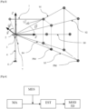
- FIG. 3 represents a wind turbine 1 equipped with a LiDAR sensor 2.
- the LiDAR sensor 2 is used to measure the wind speed at a given distance on a PM measurement point. Knowing the wind measurement in advance allows us to provide a lot of information.
- LiDAR sensor for example scanned LiDAR, continuous LiDAR or pulsed LiDAR.
- a pulsed LiDAR is preferably used.
- other LiDAR technologies can be used while remaining within the scope of the invention.
- the LiDAR used has 5 beams or measurement axes (b0, b1, b2, b3, b4).
- the acquisition and modeling method also works with a LiDAR comprising three or more beams.
- the 5-beam pulsed LiDAR sensor is mounted on a nacelle 3 of wind turbine 1.
- the space upstream of the LiDAR sensor is defined according to a mesh as visible to figures 3 , 5 and 6 .
- a coordinate system in which the Lidar performs measurements is defined.
- the defined coordinate system is the direct trihedron shown in the figures 3 And 5 .
- the x - y origins of this system are at the positioning of the LiDAR on the pod 3, and the z origin is at ground level 6.
- the x-axis points horizontally in the direction of the wind, the z-axis points vertically up, and the y-axis is perpendicular to form a direct three-dimensional frame (according to the right-hand rule).
- the space mesh includes a set of discretized points placed upstream and which define a three-dimensional grid.
- the y - z plane is divided into non-overlapping cells as visible in the figure 5 .
- the mesh includes measurement points (PM) and estimation points (PE) of the wind speed.
- optimization variables necessary for the estimation step described below.
- ⁇ an ordered vector
- a vector w is defined for each point in the discretized space and it is composed of all the components v x of the points in space (PE) where the wind is estimated, followed respectively by the components v y and v z .
- Estimating the wind speed at n points involves constructing a vector ⁇ of size 3n, with W l to W n containing all v x , W n + 1 to W 2 n containing all v y , and W 2 n + 1 to W 3 n containing all v z .
- v i,j,k the component of the wind speed v x , whose coordinate is (x i , y j , z k ).
- the LiDAR sensor carries out a measurement m(t) relating to the wind speed at a measurement point (PM) located upstream of the wind turbine 1.
- This measurement m(t) corresponds to the signal received by the sensor coming from the measurement point (PM) in response to the signal emitted by the LiDAR sensor.
- the measurement point is defined by the characteristics of the LiDAR sensor, notably the focal length, as well as its orientation. This measurement, dependent on wind speed, is a time and depends on the orientation of the LiDAR sensor.
- the measurements are obtained successively according to the mesh defined in the previous step, starting with the longitudinal beam b0, then the oblique beam b1, up to beam b4.
- An interesting feature of this system is that it allows the projection of wind speed to be measured at several distances, simultaneously, for a given beam. It is thus possible to obtain, for example, 10 successive distances between 50m and 400m, at a sampling rate of 0.25Hz or 1Hz. It is of course possible to limit our to two measurements, which are sufficient to reconstruct a three-dimensional model. At each sampling time, only the measurements of the selected current beam are refreshed.
- v j,x (k), v j,y (k), v j,z (k) are values of the wind speed projected onto a given frame at the initial time (k)
- This step consists of obtaining a wind value on the estimation points (PE) of the mesh.
- the estimation is carried out by means of optimization by a weighted recursive least squares method of a cost function which uses the measured data m(k) of the LiDAR, but also spatial coherence data of the speed wind, temporal variation data of wind speed, as well as data qualifying the quality of LiDAR m(k) measurements. This is what is explained below.
- the longitudinal difference corresponds to the change in v x along the x axis and this changes smoothly according to the invention.
- the partial derivative dv x / dx is relatively small. In other words, ⁇ ⁇ 1 ⁇ ⁇ 10 ⁇ 0 ⁇ 2 ⁇ ⁇ 11 ⁇ 0 ⁇ ⁇ 18 ⁇ ⁇ 27 ⁇ 0
- each line of C xl contains a +1 and a -1.
- VS L VS xl VS yl VS zl
- the lateral difference is the change in v x along the y axis.
- the partial derivative dv x / dy is relatively small. In other words, ⁇ ⁇ 1 ⁇ ⁇ 2 ⁇ 0 ⁇ 2 ⁇ ⁇ 3 ⁇ 0 ⁇ ⁇ 26 ⁇ ⁇ 27 ⁇ 0
- Each line of C xt contains a +1 and a -1.
- the variation of v y and v z along the lateral axis can be calculated as, ⁇ VS yt ⁇ ⁇ 0 , VS zt ⁇ ⁇ 0 where C yt , C zt are coefficient matrices which contain only one +1 and one -1 for each row.
- the vertical profile of the wind speed is given by a power law which makes it possible to obtain a description of the wind speed component v x at different heights which is much more precise.
- the vertical wind speed profile describes the evolution of the longitudinal wind speed as a function of altitude relative to the ground.
- alpha 1/7 is commonly used, consistent with an assumption of relatively low wind shear. However, it should be noted that considering alpha constant means ignoring the roughness of the ground surface, the interactions of the wind with possible obstacles, and the stability of the atmosphere.
- C yv , C zv only contain a +1 and a -1 for each line.
- VS L ⁇ ⁇ 0 And VS t ⁇ ⁇ 0 we have : ⁇ VS t ⁇ ⁇ 0 , VS t ⁇ ⁇ 0 , VS ⁇ ⁇ ⁇ 0 where equivalently, VS s ⁇ ⁇ 0 which is the equation that characterizes the variation of the total wind speed along the x, y and z axis.
- ⁇ (0) is the estimate of the wind speed at time 0.
- a processor integrated into the LiDAR sensor recovers all the wind amplitude and direction data measured and estimated during the previous steps. The recovery of this data is done in real time for each measurement point (PM) and estimation point (PE) defined previously. Thus the LiDAR sensor is able to reconstruct the entire wind field incident on the LiDAR as visible to the Figure 7 .
- a reconstructed wind field is represented for a time of 68 seconds.
- the altitude relative to the ground is represented (in m) and on the abscissa, the distance to the nacelle (in m) and the relative lateral positions to the LiDAR (in m) are represented.
- This method according to the invention makes it possible to analyze the incident wind in real time or detect gusts, power curves and turbulence intensities which can be used to regulate or supervise the wind turbine so as to obtain better alignment of the wind turbine, which leads to optimization of production and minimization of loads and fatigue.
Landscapes
- Engineering & Computer Science (AREA)
- Physics & Mathematics (AREA)
- General Physics & Mathematics (AREA)
- Electromagnetism (AREA)
- Computer Networks & Wireless Communication (AREA)
- Radar, Positioning & Navigation (AREA)
- Remote Sensing (AREA)
- Mathematical Physics (AREA)
- General Engineering & Computer Science (AREA)
- Data Mining & Analysis (AREA)
- Computational Mathematics (AREA)
- Theoretical Computer Science (AREA)
- Pure & Applied Mathematics (AREA)
- Mathematical Optimization (AREA)
- Mathematical Analysis (AREA)
- Mechanical Engineering (AREA)
- Life Sciences & Earth Sciences (AREA)
- Sustainable Development (AREA)
- Combustion & Propulsion (AREA)
- Chemical & Material Sciences (AREA)
- Sustainable Energy (AREA)
- Algebra (AREA)
- Databases & Information Systems (AREA)
- Software Systems (AREA)
- Aviation & Aerospace Engineering (AREA)
- Multimedia (AREA)
- Computing Systems (AREA)
- Optical Radar Systems And Details Thereof (AREA)
Claims (18)
- Verfahren zur Erkennung von Ausreißern eines ankommenden Windfelds in einem einem LiDAR-Sensor vorgelagerten Raum, dadurch gekennzeichnet, dass das Verfahren enthält:a) einen Schritt der Erfassung und Modellierung von Messungen rws(k) eines ankommenden Windfelds durch den LiDAR-Sensor;b) einen Schritt der Schätzung eines Medianwerts mr(k) und der mittleren absoluten Abweichung dr(k) in Echtzeit einer Modellierung der Messungen rws(k) des ankommenden Windfelds; undc) einen Schritt der Erkennung der Ausreißer in Echtzeit unter Verwendung des geschätzten Medianwerts mr(k) und der mittleren absoluten Abweichung d(rk), wobei der Erkennungsschritt durch eine Formel des Typs: |rws(k) -mr(k)| ≤ σdr(k) durchgeführt wird, wobei σ ein positiver Skalar ist.
- Erkennungsverfahren nach Anspruch 1, dadurch gekennzeichnet, dass die mittlere absolute Abweichung dr(k) in Echtzeit des ankommenden Windfelds durch eine Formel des Typs angegeben wird:

- Erkennungsverfahren nach einem der vorhergehenden Ansprüche, dadurch gekennzeichnet, dass das Verfahren einen Schritt der Rekonstruktion der Messung des LiDAR-Sensors durch Entfernen der erkannten Ausreißer der Messmodellierung rws(k) aufweist.
- Erkennungsverfahren nach einem der vorhergehenden Ansprüche, dadurch gekennzeichnet, dass der Schritt der Erfassung und Modellierung durch den LiDAR-Sensor eines ankommenden Windfelds in dem dem LiDAR-Sensor vorgelagerten Raum die folgenden Schritte enthält:a) einen Schritt der Vermaschung (MA) des dem LiDAR-Sensor vorgelagerten Raums, wobei die Vermaschung des Raums von einer Einheit von diskretisierten Punkten durchgeführt wird, die gemäß einem vordefinierten dreidimensionalen Gitter positioniert sind, das eine Einheit von Maschen enthält, die aus Schätzpunkten und Messpunkten (PM) zusammengesetzt sind,b) einen Messschritt (MES) der Amplitude und der Richtung des Winds an den verschiedenen Messpunkten (PM), die sich im vorgelagerten Raum befinden und in mindestens zwei unterschiedlichen Abständen zum LiDAR-Sensor entlang mindestens drei Messachsen positioniert sind,c) einen Schätzschritt (EST) der Amplitude und der Richtung des Winds zu einem beliebigen Zeitpunkt (t) an der Gesamtheit der Schätzpunkte, und die Schätzung wird mittels der Optimierung durch eine Methode der gewichteten rekursiven kleinsten Quadrate einer Kostenfunktion ausgeführt, die mindestens die Daten der Messpunkte (PM), Daten räumlicher Kohärenz der Windgeschwindigkeit, Daten zeitlicher Kohärenz der Windgeschwindigkeit, sowie Daten verwendet, die die Qualität der an den Messpunkten ausgeführten Messungen qualifizieren,d) einen Schritt der Rekonstruktion (MOD 3D), in Echtzeit und in einem definierten Bezugssystem, des ankommenden Windfelds in drei Dimensionen (3D) ausgehend von den für jeden Punkt der Vermaschung (MA) geschätzten und gemessenen Amplituden und Richtungen des Winds.
- Erkennungsverfahren nach Anspruch 4, dadurch gekennzeichnet, dass die Messung der Amplitude und der Richtung des Winds an einem Messpunkt (PM) durch eine Beziehung der Form gegeben wird:


- Erkennungsverfahren nach einem der Ansprüche 4 oder 5, dadurch gekennzeichnet, dass die Kostenfunktion J zu einem beliebigen Zeitpunkt (t) folgendermaßen geschrieben wird:

- Erkennungsverfahren nach einem der Ansprüche 4 bis 6, dadurch gekennzeichnet, dass die Messungen der Amplitude und der Richtung des Winds an den verschiedenen Messpunkten (PM) mit einer Abtastrate von mindestens 0.25Hz ausgeführt werden.
- Erkennungsverfahren nach einem der Ansprüche 4 bis 7, dadurch gekennzeichnet, dass die Messungen der Amplitude und der Richtung des Winds an den verschiedenen Messpunkten (PM) in mindestens zwei verschiedenen Abständen entlang der Messachse vorgenommen werden.
- Erkennungsverfahren nach einem der Ansprüche 4 bis 8, dadurch gekennzeichnet, dass die Messungen der Amplitude und der Richtung des Winds entlang von mindestens drei Messachsen vorgenommen werden.
- Erkennungsverfahren nach einem der Ansprüche 4 bis 9, dadurch gekennzeichnet, dass die räumliche Kohärenz der Windgeschwindigkeit gemäß den Achsen x, y und z eines kartesischen Koordinatensystems durch eine Formel des Typs geschätzt wird:
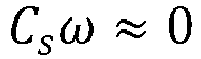
 o Ci die Änderung der Windgeschwindigkeit für einen Schätzbereich entlang der Längsachse x charakterisiert, undo Ct die Änderung der Windgeschwindigkeit für einen Schätzbereich entlang der Seitenachse y charakterisiert, und∘ Cv die Änderung der Windgeschwindigkeit für einen Schätzbereich entlang der senkrechten Achse z charakterisiert, und∘ der Vektor ω ein geordneter Vektor ist, der aus allen Komponenten der Windgeschwindigkeit an den Punkten des Raums zusammengesetzt ist, wo der Wind geschätzt wird.
 - Erkennungsverfahren nach einem der Ansprüche 4 bis 10, dadurch gekennzeichnet, dass die räumliche Kohärenz der Windgeschwindigkeit gemäß den Achsen x, y und z des kartesischen Koordinatensystems mit den folgenden Hypothesen geschätzt wird:o die Änderung der Windgeschwindigkeit entlang der Längsachse x ist schwach, und die partielle Ableitung dvx/dx entlang der Längsachse ist relativ klein,o der Wind ändert sich stufenlos entlang der Seitenachse y, und die partielle Ableitung dvx/dy entlang der Seitenachse y ist klein,o der Wind ändert sich mit einem Leistungsgesetz gemäß der senkrechten Achse z, das gegeben wird durch:

- Erkennungsverfahren nach einem der Ansprüche 4 bis 11, dadurch gekennzeichnet, dass die Qualität der vom LiDAR-Sensor ausgeführten Messungen durch ein Modell der Form dargestellt wird:

- Erkennungsverfahren nach einem der Ansprüche 4 bis 12, dadurch gekennzeichnet, dass die Schätzung der Amplituden und der Richtungen des Windfelds zu einem Zeitpunkt (t) über die Gesamtheit der Schätzpunkte durch die folgende Formel angegeben wird:

- Computerprogrammprodukt, dadurch gekennzeichnet, dass es Codeanweisungen enthält, die eingerichtet sind, um die Schritte eines Erkennungsverfahrens eines ankommenden Windfelds durch einen LiDAR-Sensor nach einem der vorhergehenden Ansprüche durchzuführen, wenn das Programm auf einer Verarbeitungseinheit des LiDAR-Sensors ausgeführt wird.
- LiDAR-Sensor, dadurch gekennzeichnet, dass er im Speicher die Codeanweisungen eines Computerprogrammprodukts nach dem vorhergehenden Anspruch enthält und eingerichtet ist, um ein solches Computerprogrammprodukt auszuführen.
- Windkraftanlage 1, dadurch gekennzeichnet, dass die Windkraftanlage 1 einen LiDAR-Sensor 2 nach dem vorhergehenden Anspruch enthält.
- Windkraftanlage 1 nach dem vorhergehenden Anspruch, dadurch gekennzeichnet, dass der LiDAR-Sensor auf der Gondel der Windkraftanlage angeordnet ist.
- Verfahren zur Kontrolle und/oder Überwachung einer Windkraftanlage 1, die mit einem LiDAR-Sensor 2 und einem Steuerautomaten ausgestattet ist, dadurch gekennzeichnet, dass die folgenden Schritte durchgeführt werden:i) ein Schritt der Erkennung von Ausreißern eines ankommenden Windfelds in einem einem LiDAR-Sensor vorgelagerten Raum und einen Schritt nach einem der Ansprüche 1 bis 13,ii) einen Steuerschritt (PIL), der die ausgearbeitete Kontrollstrategie umfasst, die darin besteht, den Winkel von Blättern 7 oder die Ausrichtung einer Gondel 3 ohne Berücksichtigung der erkannten Ausreißer zu steuern.
Applications Claiming Priority (1)
| Application Number | Priority Date | Filing Date | Title |
|---|---|---|---|
| FR1871844A FR3088971B1 (fr) | 2018-11-26 | 2018-11-26 | procédé d’acquisition et de modélisation par un capteur LIDAR d’un champ de vent incident |
Publications (3)
| Publication Number | Publication Date |
|---|---|
| EP3657217A1 EP3657217A1 (de) | 2020-05-27 |
| EP3657217B1 true EP3657217B1 (de) | 2023-12-06 |
| EP3657217C0 EP3657217C0 (de) | 2023-12-06 |
Family
ID=66166159
Family Applications (1)
| Application Number | Title | Priority Date | Filing Date |
|---|---|---|---|
| EP19206135.6A Active EP3657217B1 (de) | 2018-11-26 | 2019-10-30 | Erfassungs- und modellierungsverfahren eines umgebungswindfelds durch einen lidar-sensor |
Country Status (7)
| Country | Link |
|---|---|
| US (1) | US11520053B2 (de) |
| EP (1) | EP3657217B1 (de) |
| CN (1) | CN111221003B (de) |
| CA (1) | CA3062466A1 (de) |
| ES (1) | ES2972903T3 (de) |
| FR (1) | FR3088971B1 (de) |
| PL (1) | PL3657217T3 (de) |
Families Citing this family (10)
| Publication number | Priority date | Publication date | Assignee | Title |
|---|---|---|---|---|
| FR3068139B1 (fr) * | 2017-06-21 | 2019-12-20 | IFP Energies Nouvelles | Procede d'acquisition et de modelisation par un capteur lidar d'un champ de vent incident |
| FR3114881B1 (fr) * | 2020-10-01 | 2022-09-09 | Ifp Energies Now | Procédé de détermination de la vitesse moyenne du vent au moyen d’un capteur de télédétection par Laser |
| FR3116123B1 (fr) | 2020-11-06 | 2022-10-14 | Ifp Energies Now | Procédé de détermination de la vitesse du vent dans le plan du rotor d’une éolienne |
| FR3126248B1 (fr) | 2021-08-20 | 2023-07-28 | Ifp Energies Now | Procédé de détermination de la vitesse du vent au moyen d’un capteur de télédétection par Laser monté sur une éolienne |
| CN115730860B (zh) * | 2022-11-29 | 2024-06-14 | 中国华能集团清洁能源技术研究院有限公司 | 基于全物理过程的风电场实时功率估算方法及系统 |
| CN116027356A (zh) * | 2022-12-05 | 2023-04-28 | 南京牧镭激光科技股份有限公司 | 一种远程激光测风雷达系统方法 |
| CN116066296B (zh) * | 2023-03-05 | 2026-04-14 | 河北诚和龙盛电力工程有限公司 | 风力发电机组偏航控制系统 |
| CN117108447B (zh) * | 2023-08-24 | 2024-08-30 | 华能会理风力发电有限公司 | 一种基于测风激光雷达的多机组控制方法和系统 |
| CN118859243B (zh) * | 2024-09-12 | 2024-12-06 | 南京信息工程大学 | 一种基于激光雷达遥感的生态系统碳源汇测量方法及系统 |
| CN119914464B (zh) * | 2025-03-21 | 2025-07-25 | 北京雅德士工程技术咨询服务有限公司 | 一种基于多雷达时空同步的桨距角动态补偿方法 |
Family Cites Families (14)
| Publication number | Priority date | Publication date | Assignee | Title |
|---|---|---|---|---|
| US7827861B2 (en) * | 2007-06-01 | 2010-11-09 | Second Wind, Inc. | Position correction in sodar and meteorological lidar systems |
| US20110313726A1 (en) * | 2009-03-05 | 2011-12-22 | Honeywell International Inc. | Condition-based maintenance system for wind turbines |
| US8219356B2 (en) * | 2010-12-23 | 2012-07-10 | General Electric Company | System and method for detecting anomalies in wind turbines |
| WO2012146258A1 (en) * | 2011-04-28 | 2012-11-01 | Vestas Wind Systems A/S | Method and appartaus for protecting wind turbines from extreme events |
| US10027952B2 (en) * | 2011-08-04 | 2018-07-17 | Trx Systems, Inc. | Mapping and tracking system with features in three-dimensional space |
| US20130184838A1 (en) * | 2012-01-06 | 2013-07-18 | Michigan Aerospace Corporation | Resource optimization using environmental and condition-based monitoring |
| US9784887B1 (en) * | 2013-08-12 | 2017-10-10 | Physical Optics Corporation | Meteorological sensing systems and methods |
| FR3013777B1 (fr) | 2013-11-25 | 2015-11-13 | IFP Energies Nouvelles | Procede de controle et de surveillance d'une eolienne au moyen d'une estimation de la vitesse du vent au moyen d'un capteur lidar |
| CN103996085B (zh) * | 2014-06-09 | 2015-03-11 | 中南大学 | 铁路沿线近地风场点域映射空间预测方法 |
| CN104077632B (zh) * | 2014-06-23 | 2017-07-07 | 华北电力大学 | 一种基于深度神经网络的风电场功率预测方法 |
| EP3298521B1 (de) * | 2015-05-19 | 2021-09-08 | Ophir Corporation | Systeme und verfahren zur vorhersage des eintreffens eines windereignisses |
| CN105738915B (zh) * | 2016-01-07 | 2017-09-26 | 福州华鹰重工机械有限公司 | 三维雷达测量方法及装置 |
| WO2017185049A1 (en) * | 2016-04-22 | 2017-10-26 | Cylance Inc. | Dimensionality reduction of computer programs |
| CN106503861B (zh) * | 2016-11-08 | 2020-09-11 | 中国地质大学(武汉) | 基于概率统计和粒子群优化的多气象源风速融合的风电功率预测方法 |
-
2018
- 2018-11-26 FR FR1871844A patent/FR3088971B1/fr active Active
-
2019
- 2019-10-30 ES ES19206135T patent/ES2972903T3/es active Active
- 2019-10-30 PL PL19206135.6T patent/PL3657217T3/pl unknown
- 2019-10-30 EP EP19206135.6A patent/EP3657217B1/de active Active
- 2019-11-21 CA CA3062466A patent/CA3062466A1/fr active Pending
- 2019-11-26 US US16/695,873 patent/US11520053B2/en active Active
- 2019-11-26 CN CN201911173924.0A patent/CN111221003B/zh active Active
Also Published As
| Publication number | Publication date |
|---|---|
| FR3088971B1 (fr) | 2021-02-19 |
| PL3657217T3 (pl) | 2024-06-24 |
| FR3088971A1 (fr) | 2020-05-29 |
| US20200166650A1 (en) | 2020-05-28 |
| ES2972903T3 (es) | 2024-06-17 |
| CN111221003A (zh) | 2020-06-02 |
| CN111221003B (zh) | 2024-12-13 |
| EP3657217C0 (de) | 2023-12-06 |
| US11520053B2 (en) | 2022-12-06 |
| CA3062466A1 (fr) | 2020-05-26 |
| EP3657217A1 (de) | 2020-05-27 |
Similar Documents
| Publication | Publication Date | Title |
|---|---|---|
| EP3642647B1 (de) | Verfahren zur erfassung und modellierung eines einfallswindfelds unter verwendung eines lidarsensors | |
| EP3657217A1 (de) | Erfassungs- und modellierungsverfahren eines umgebungswindfelds durch einen lidar-sensor | |
| EP2876302B1 (de) | Kontroll- und überwachungsverfahren einer windkraftanlage anhand einer windgeschwindigkeitsschätzung mit hilfe eines lidar-sensors | |
| EP3754341B1 (de) | Bestimmungsverfahren des vertikalen profils der aufwärts gemessenen windgeschwindigkeit einer windkraftanlage, die mit einem laserfernerkennungssensor ausgestattet ist | |
| EP3650687B1 (de) | Bestimmungsverfahren eines induktionsfaktors für eine windkraftanlage, die mit einem laserfernerkennungssensor ausgestattet ist | |
| CA3226598A1 (fr) | Procede de determination de la vitesse du vent au moyen d'un capteur de teledetection par laser monte sur une eolienne | |
| Zhu et al. | A visual measurement method of structural body vibration displacement combined with image deblurring | |
| FR3094093A1 (fr) | Procédé de prédiction de la vitesse du vent dans le plan du rotor pour une éolienne équipée d’un capteur de télédétection par Laser | |
| EP3995834B1 (de) | Verfahren zur bestimmung der windgeschwindigkeit in der rotorebene einer windkraftanlage | |
| EP3978934B1 (de) | Verfahren zur bestimmung der durchschnittlichen windgeschwindigkeit mithilfe eines laser-fernerkennungssensors | |
| EP4162298B1 (de) | Verfahren zur bestimmung von windgeschwindigkeitskomponenten mittels eines laser-fernsensors | |
| WO2025186339A1 (fr) | Systeme de supervision d'un parc eolien | |
| Curt et al. | Modal analysis of a wind turbine tower by digital image correlation | |
| EP3985250B1 (de) | Verfahren zur bestimmung eines induktionsfaktors zwischen einer messebene und der ebene des rotors einer windkraftanlage | |
| EP4172648B1 (de) | Verfahren zur bestimmung von windgeschwindigkeitskomponenten mittels eines laser-fernsensors und mittels einer zeitlichen kohärenz | |
| EP3380947B1 (de) | Verfahren und vorrichtung zur prognose der bewölkung durch statistische verarbeitung von durch räumliche analyse ausgewählten daten | |
| Paulescu et al. | Intra-hour PV power forecasting based on sky imagery | |
| FR3147330A1 (fr) | Procédé de détermination de la vitesse de vent libre pour une ferme d’éoliennes |
Legal Events
| Date | Code | Title | Description |
|---|---|---|---|
| PUAI | Public reference made under article 153(3) epc to a published international application that has entered the european phase |
Free format text: ORIGINAL CODE: 0009012 |
|
| STAA | Information on the status of an ep patent application or granted ep patent |
Free format text: STATUS: THE APPLICATION HAS BEEN PUBLISHED |
|
| AK | Designated contracting states |
Kind code of ref document: A1 Designated state(s): AL AT BE BG CH CY CZ DE DK EE ES FI FR GB GR HR HU IE IS IT LI LT LU LV MC MK MT NL NO PL PT RO RS SE SI SK SM TR |
|
| AX | Request for extension of the european patent |
Extension state: BA ME |
|
| STAA | Information on the status of an ep patent application or granted ep patent |
Free format text: STATUS: REQUEST FOR EXAMINATION WAS MADE |
|
| 17P | Request for examination filed |
Effective date: 20201127 |
|
| RBV | Designated contracting states (corrected) |
Designated state(s): AL AT BE BG CH CY CZ DE DK EE ES FI FR GB GR HR HU IE IS IT LI LT LU LV MC MK MT NL NO PL PT RO RS SE SI SK SM TR |
|
| STAA | Information on the status of an ep patent application or granted ep patent |
Free format text: STATUS: EXAMINATION IS IN PROGRESS |
|
| 17Q | First examination report despatched |
Effective date: 20220816 |
|
| GRAP | Despatch of communication of intention to grant a patent |
Free format text: ORIGINAL CODE: EPIDOSNIGR1 |
|
| STAA | Information on the status of an ep patent application or granted ep patent |
Free format text: STATUS: GRANT OF PATENT IS INTENDED |
|
| INTG | Intention to grant announced |
Effective date: 20230628 |
|
| GRAS | Grant fee paid |
Free format text: ORIGINAL CODE: EPIDOSNIGR3 |
|
| GRAA | (expected) grant |
Free format text: ORIGINAL CODE: 0009210 |
|
| STAA | Information on the status of an ep patent application or granted ep patent |
Free format text: STATUS: THE PATENT HAS BEEN GRANTED |
|
| AK | Designated contracting states |
Kind code of ref document: B1 Designated state(s): AL AT BE BG CH CY CZ DE DK EE ES FI FR GB GR HR HU IE IS IT LI LT LU LV MC MK MT NL NO PL PT RO RS SE SI SK SM TR |
|
| REG | Reference to a national code |
Ref country code: GB Ref legal event code: FG4D Free format text: NOT ENGLISH |
|
| REG | Reference to a national code |
Ref country code: CH Ref legal event code: EP |
|
| REG | Reference to a national code |
Ref country code: DE Ref legal event code: R096 Ref document number: 602019042732 Country of ref document: DE |
|
| REG | Reference to a national code |
Ref country code: IE Ref legal event code: FG4D Free format text: LANGUAGE OF EP DOCUMENT: FRENCH |
|
| U01 | Request for unitary effect filed |
Effective date: 20240102 |
|
| U07 | Unitary effect registered |
Designated state(s): AT BE BG DE DK EE FI FR IT LT LU LV MT NL PT SE SI Effective date: 20240108 |
|
| PG25 | Lapsed in a contracting state [announced via postgrant information from national office to epo] |
Ref country code: GR Free format text: LAPSE BECAUSE OF FAILURE TO SUBMIT A TRANSLATION OF THE DESCRIPTION OR TO PAY THE FEE WITHIN THE PRESCRIBED TIME-LIMIT Effective date: 20240307 |
|
| PG25 | Lapsed in a contracting state [announced via postgrant information from national office to epo] |
Ref country code: GR Free format text: LAPSE BECAUSE OF FAILURE TO SUBMIT A TRANSLATION OF THE DESCRIPTION OR TO PAY THE FEE WITHIN THE PRESCRIBED TIME-LIMIT Effective date: 20240307 |
|
| PG25 | Lapsed in a contracting state [announced via postgrant information from national office to epo] |
Ref country code: RS Free format text: LAPSE BECAUSE OF FAILURE TO SUBMIT A TRANSLATION OF THE DESCRIPTION OR TO PAY THE FEE WITHIN THE PRESCRIBED TIME-LIMIT Effective date: 20231206 Ref country code: HR Free format text: LAPSE BECAUSE OF FAILURE TO SUBMIT A TRANSLATION OF THE DESCRIPTION OR TO PAY THE FEE WITHIN THE PRESCRIBED TIME-LIMIT Effective date: 20231206 |
|
| REG | Reference to a national code |
Ref country code: ES Ref legal event code: FG2A Ref document number: 2972903 Country of ref document: ES Kind code of ref document: T3 Effective date: 20240617 |
|
| PG25 | Lapsed in a contracting state [announced via postgrant information from national office to epo] |
Ref country code: IS Free format text: LAPSE BECAUSE OF FAILURE TO SUBMIT A TRANSLATION OF THE DESCRIPTION OR TO PAY THE FEE WITHIN THE PRESCRIBED TIME-LIMIT Effective date: 20240406 |
|
| PG25 | Lapsed in a contracting state [announced via postgrant information from national office to epo] |
Ref country code: CZ Free format text: LAPSE BECAUSE OF FAILURE TO SUBMIT A TRANSLATION OF THE DESCRIPTION OR TO PAY THE FEE WITHIN THE PRESCRIBED TIME-LIMIT Effective date: 20231206 |
|
| PG25 | Lapsed in a contracting state [announced via postgrant information from national office to epo] |
Ref country code: SK Free format text: LAPSE BECAUSE OF FAILURE TO SUBMIT A TRANSLATION OF THE DESCRIPTION OR TO PAY THE FEE WITHIN THE PRESCRIBED TIME-LIMIT Effective date: 20231206 |
|
| PG25 | Lapsed in a contracting state [announced via postgrant information from national office to epo] |
Ref country code: SM Free format text: LAPSE BECAUSE OF FAILURE TO SUBMIT A TRANSLATION OF THE DESCRIPTION OR TO PAY THE FEE WITHIN THE PRESCRIBED TIME-LIMIT Effective date: 20231206 Ref country code: SK Free format text: LAPSE BECAUSE OF FAILURE TO SUBMIT A TRANSLATION OF THE DESCRIPTION OR TO PAY THE FEE WITHIN THE PRESCRIBED TIME-LIMIT Effective date: 20231206 Ref country code: RO Free format text: LAPSE BECAUSE OF FAILURE TO SUBMIT A TRANSLATION OF THE DESCRIPTION OR TO PAY THE FEE WITHIN THE PRESCRIBED TIME-LIMIT Effective date: 20231206 Ref country code: IS Free format text: LAPSE BECAUSE OF FAILURE TO SUBMIT A TRANSLATION OF THE DESCRIPTION OR TO PAY THE FEE WITHIN THE PRESCRIBED TIME-LIMIT Effective date: 20240406 Ref country code: CZ Free format text: LAPSE BECAUSE OF FAILURE TO SUBMIT A TRANSLATION OF THE DESCRIPTION OR TO PAY THE FEE WITHIN THE PRESCRIBED TIME-LIMIT Effective date: 20231206 |
|
| REG | Reference to a national code |
Ref country code: DE Ref legal event code: R097 Ref document number: 602019042732 Country of ref document: DE |
|
| PLBE | No opposition filed within time limit |
Free format text: ORIGINAL CODE: 0009261 |
|
| STAA | Information on the status of an ep patent application or granted ep patent |
Free format text: STATUS: NO OPPOSITION FILED WITHIN TIME LIMIT |
|
| 26N | No opposition filed |
Effective date: 20240909 |
|
| U20 | Renewal fee for the european patent with unitary effect paid |
Year of fee payment: 6 Effective date: 20241031 |
|
| REG | Reference to a national code |
Ref country code: CH Ref legal event code: PL |
|
| PG25 | Lapsed in a contracting state [announced via postgrant information from national office to epo] |
Ref country code: MC Free format text: LAPSE BECAUSE OF FAILURE TO SUBMIT A TRANSLATION OF THE DESCRIPTION OR TO PAY THE FEE WITHIN THE PRESCRIBED TIME-LIMIT Effective date: 20231206 |
|
| PG25 | Lapsed in a contracting state [announced via postgrant information from national office to epo] |
Ref country code: CH Free format text: LAPSE BECAUSE OF NON-PAYMENT OF DUE FEES Effective date: 20241031 |
|
| PG25 | Lapsed in a contracting state [announced via postgrant information from national office to epo] |
Ref country code: IE Free format text: LAPSE BECAUSE OF NON-PAYMENT OF DUE FEES Effective date: 20241030 |
|
| U20 | Renewal fee for the european patent with unitary effect paid |
Year of fee payment: 7 Effective date: 20251031 |
|
| PGFP | Annual fee paid to national office [announced via postgrant information from national office to epo] |
Ref country code: GB Payment date: 20251021 Year of fee payment: 7 |
|
| PGFP | Annual fee paid to national office [announced via postgrant information from national office to epo] |
Ref country code: NO Payment date: 20251020 Year of fee payment: 7 |
|
| PGFP | Annual fee paid to national office [announced via postgrant information from national office to epo] |
Ref country code: PL Payment date: 20251017 Year of fee payment: 7 |
|
| PGFP | Annual fee paid to national office [announced via postgrant information from national office to epo] |
Ref country code: ES Payment date: 20251118 Year of fee payment: 7 |
|
| PG25 | Lapsed in a contracting state [announced via postgrant information from national office to epo] |
Ref country code: HU Free format text: LAPSE BECAUSE OF FAILURE TO SUBMIT A TRANSLATION OF THE DESCRIPTION OR TO PAY THE FEE WITHIN THE PRESCRIBED TIME-LIMIT; INVALID AB INITIO Effective date: 20191030 |
|
| PG25 | Lapsed in a contracting state [announced via postgrant information from national office to epo] |
Ref country code: CY Free format text: LAPSE BECAUSE OF FAILURE TO SUBMIT A TRANSLATION OF THE DESCRIPTION OR TO PAY THE FEE WITHIN THE PRESCRIBED TIME-LIMIT; INVALID AB INITIO Effective date: 20191030 |