EP4162298B1 - Verfahren zur bestimmung von windgeschwindigkeitskomponenten mittels eines laser-fernsensors - Google Patents
Verfahren zur bestimmung von windgeschwindigkeitskomponenten mittels eines laser-fernsensors Download PDFInfo
- Publication number
- EP4162298B1 EP4162298B1 EP21725221.2A EP21725221A EP4162298B1 EP 4162298 B1 EP4162298 B1 EP 4162298B1 EP 21725221 A EP21725221 A EP 21725221A EP 4162298 B1 EP4162298 B1 EP 4162298B1
- Authority
- EP
- European Patent Office
- Prior art keywords
- wind speed
- wind
- components
- measurement
- measurement signals
- Prior art date
- Legal status (The legal status is an assumption and is not a legal conclusion. Google has not performed a legal analysis and makes no representation as to the accuracy of the status listed.)
- Active
Links
Images

Classifications
-
- G—PHYSICS
- G01—MEASURING; TESTING
- G01S—RADIO DIRECTION-FINDING; RADIO NAVIGATION; DETERMINING DISTANCE OR VELOCITY BY USE OF RADIO WAVES; LOCATING OR PRESENCE-DETECTING BY USE OF THE REFLECTION OR RERADIATION OF RADIO WAVES; ANALOGOUS ARRANGEMENTS USING OTHER WAVES
- G01S17/00—Systems using the reflection or reradiation of electromagnetic waves other than radio waves, e.g. lidar systems
- G01S17/02—Systems using the reflection of electromagnetic waves other than radio waves
- G01S17/50—Systems of measurement based on relative movement of target
- G01S17/58—Velocity or trajectory determination systems; Sense-of-movement determination systems
-
- G—PHYSICS
- G01—MEASURING; TESTING
- G01S—RADIO DIRECTION-FINDING; RADIO NAVIGATION; DETERMINING DISTANCE OR VELOCITY BY USE OF RADIO WAVES; LOCATING OR PRESENCE-DETECTING BY USE OF THE REFLECTION OR RERADIATION OF RADIO WAVES; ANALOGOUS ARRANGEMENTS USING OTHER WAVES
- G01S17/00—Systems using the reflection or reradiation of electromagnetic waves other than radio waves, e.g. lidar systems
- G01S17/88—Lidar systems specially adapted for specific applications
- G01S17/95—Lidar systems specially adapted for specific applications for meteorological use
-
- G—PHYSICS
- G01—MEASURING; TESTING
- G01S—RADIO DIRECTION-FINDING; RADIO NAVIGATION; DETERMINING DISTANCE OR VELOCITY BY USE OF RADIO WAVES; LOCATING OR PRESENCE-DETECTING BY USE OF THE REFLECTION OR RERADIATION OF RADIO WAVES; ANALOGOUS ARRANGEMENTS USING OTHER WAVES
- G01S7/00—Details of systems according to groups G01S13/00, G01S15/00, G01S17/00
- G01S7/48—Details of systems according to groups G01S13/00, G01S15/00, G01S17/00 of systems according to group G01S17/00
- G01S7/4808—Evaluating distance, position or velocity data
-
- Y—GENERAL TAGGING OF NEW TECHNOLOGICAL DEVELOPMENTS; GENERAL TAGGING OF CROSS-SECTIONAL TECHNOLOGIES SPANNING OVER SEVERAL SECTIONS OF THE IPC; TECHNICAL SUBJECTS COVERED BY FORMER USPC CROSS-REFERENCE ART COLLECTIONS [XRACs] AND DIGESTS
- Y02—TECHNOLOGIES OR APPLICATIONS FOR MITIGATION OR ADAPTATION AGAINST CLIMATE CHANGE
- Y02A—TECHNOLOGIES FOR ADAPTATION TO CLIMATE CHANGE
- Y02A90/00—Technologies having an indirect contribution to adaptation to climate change
- Y02A90/10—Information and communication technologies [ICT] supporting adaptation to climate change, e.g. for weather forecasting or climate simulation
-
- Y—GENERAL TAGGING OF NEW TECHNOLOGICAL DEVELOPMENTS; GENERAL TAGGING OF CROSS-SECTIONAL TECHNOLOGIES SPANNING OVER SEVERAL SECTIONS OF THE IPC; TECHNICAL SUBJECTS COVERED BY FORMER USPC CROSS-REFERENCE ART COLLECTIONS [XRACs] AND DIGESTS
- Y02—TECHNOLOGIES OR APPLICATIONS FOR MITIGATION OR ADAPTATION AGAINST CLIMATE CHANGE
- Y02E—REDUCTION OF GREENHOUSE GAS [GHG] EMISSIONS, RELATED TO ENERGY GENERATION, TRANSMISSION OR DISTRIBUTION
- Y02E10/00—Energy generation through renewable energy sources
- Y02E10/70—Wind energy
- Y02E10/72—Wind turbines with rotation axis in wind direction
Definitions
- the size of the wind turbine, its class and its structure depend on wind characteristics, such as the average wind speed, the maximum wind speed, the intensity of wind turbulence (which corresponds to the ratio of the standard deviation of the wind speed to the average wind speed), etc.
- the size of the wind turbine can be chosen based on the distribution of the average wind value
- the class of the wind turbine can be chosen based on the intensity of turbulence. Since changing from one class of wind turbine to another has a significant cost, it is important to have a good understanding of the wind characteristics before installing a wind turbine.
- determining the components of wind speed is particularly critical because it also allows us to determine the energy-producing resource. This is important for wind projects, as it also determines the financial reliability of the wind turbine installation project.
- the classic technique is the installation of a measuring mast at the measurement site.
- a measuring mast is equipped with a large number of sensors and requires a specific installation, which involves a significant cost and is not easy to move from one site to another due to its dimensions.
- a second technique involves using a LiDAR sensor (acronym for light detection and ranging) (from the English term "light amplification by stimulated emission of radiation”).
- LiDAR is a remote sensing or optical measurement technology based on analyzing the properties of a beam reflected back to its emitter. This method is used in particular for determine the distance to an object using a pulsed laser. Unlike radar based on a similar principle, the LiDAR sensor uses visible or infrared light instead of radio waves.
- the LiDAR sensor In the field of wind turbines, the LiDAR sensor is announced as an essential sensor for the proper operation of large wind turbines, especially as their size and power increase (today, 5 MW, soon 12 MW offshore). This sensor allows remote measurement of the wind, initially allowing the calibration of wind turbines so that they can provide maximum power (optimization of the power curve).
- the LiDAR sensor can be positioned on the ground and oriented vertically (profiler), which makes it possible to measure the wind speed and its direction, as well as the wind gradient according to altitude. This technique can be called land-based LIDAR.
- the radial measurement does not provide a complete wind measurement. It is a projection of the wind on the beam's line of sight, filtered by the spatial transfer function inherent in LiDAR measurement technology, and noisy by the measurement chain. To obtain information representative of the wind field passing above the installed LiDAR, it is therefore necessary to combine several radial measurements together, and to associate them with a processing capable of restoring the contribution of the wind in each measurement and deriving a wind field or vector.
- Standard reconstructions are based on the assumption that the radial measurement contains only content consistent with the measured wind, and that the wind field is uniform and homogeneous at a given altitude.
- the aim of the present invention is to determine the components of wind speed in a precise, robust, reliable and inexpensive manner.
- the invention relates to a method for determining the components of wind speed using a land-based LiDAR sensor.
- the components of wind speed are first approximated using signals from the LiDAR sensor, these approximations are used in a wind signal model and then in a non-stationary Kalman filter to construct filtered measurement signals.
- the filtered measurement signals are then used to reconstruct the wind speed components. Approximating the wind speed components allows for the construction of a reliable and robust model of the wind signal, which allows for the determination of the wind speed components in a reliable and robust manner.
- the process makes it possible to obtain an estimate of the wind (amplitude and direction) whose mean and standard deviation will be more representative and realistic.
- This allows the use of a LiDAR installed as a replacement or in addition to a measurement mast, in order to carry out efficient, precise and potentially less expensive site analyses.
- the method comprises a step of filtering said measurement signals by a first-order low-pass filter for the step of approximating said components of the wind speed.
- said wind signal model corresponds to a Kaimal model of the wind spectrum.
- the covariance matrix of said non-stationary Kalman filter is determined by minimizing a cost function taking into account the dispersion and the mean deviation of said measurement signals.
- the reconstruction of the wind speed components by means of the measurement signals filtered by said non-stationary Kalman filter is implemented by means of a geometric reconstruction of said wind speed components from said measurement signals filtered by said non-stationary Kalman filter.
- said predetermined time interval is between 1 min and 1 hour, and preferably between 5 min and 30 min.
- said at least one characteristic of the wind is chosen from: the average of the wind speed, the standard deviation of the wind speed, the maximum of the wind speed, the average of the wind direction, the intensity of the wind turbulence, the average of the vertical component of the wind speed, and the standard deviation of the vertical component of the wind speed.
- the present invention relates to a method for determining wind speed components using a LiDAR sensor.
- Wind speed components are defined as projections of wind speed into a reference frame, in particular into an orthonormal reference frame.
- the LiDAR sensor is directed substantially vertically, in other words, the measurement is directed along a substantially vertical axis.
- the LiDAR sensor can be placed on the ground and oriented vertically.
- the LiDAR sensor makes it possible to measure the wind speed on at least one measurement plane. Given the orientation of the LiDAR sensor, the measurement plane is substantially horizontal.
- LiDAR sensor for example scanned LiDAR, continuous LiDAR or pulsed LiDAR sensors.
- a pulsed LiDAR is preferably used.
- other LiDAR technologies can be used while remaining within the scope of the invention.
- the LiDAR sensor allows for continuous measurement. Therefore, the use of such a sensor allows for continuous determination of measurement signals.
- the LiDAR sensor is easily movable from one site to another.
- the sampling rate of the LiDAR sensor can be between 0.1 and 5 Hz (or even higher in the future), and can be as low as 1 Hz.
- the LiDAR sensor allows for obtaining relative information in several measurement planes at several heights. Therefore, the LiDAR sensor can be used for determining wind speed components at several heights, which can be used, among other things, to determine the variation of wind speed as a function of height.
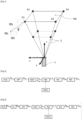
- FIG. 1 represents, in a schematic and non-limiting manner, a LiDAR sensor 1 placed and oriented vertically for the method according to an embodiment of the invention.
- the LiDAR sensor 1 is used to obtain at least one measurement signal on at least one plane PM measurement planes (only two measurement planes are shown).
- the x, y and z axes are also shown.
- the reference point of this coordinate system is the center of the LiDAR sensor.
- the x direction is a horizontal direction.
- the y direction, perpendicular to the x direction is a second horizontal direction (the x, y directions form a horizontal plane).
- the z direction is the vertical direction (corresponding to the measurement direction of the LiDAR sensor 1) directed upwards, the z axis is perpendicular to the x and y axes.
- the PM measurement planes are planes formed by the x, y directions at a distance from the LiDAR sensor 1 (for a non-zero value of z).
- the PM measurement planes are parallel to each other.
- the LiDAR sensor 1 used comprises four beams or measurement axes 2.
- the measurement beams 2 are inclined relative to the vertical axis z.
- the method according to the invention also works with a LiDAR sensor comprising any number of beams.
- the LiDAR sensor performs a point measurement at each measurement point (b1, b2, b3, b4) which are points of intersection of a measurement plane PM and a beam 2. These measurement points (b1, b2, b3, b4) are represented by black circles on the Figure 1 .
- the wind speed vector W is also represented only at point b1, and these three components Wx, Wy, Wz respectively on the x, y and z axes.
- Steps 2 to 7 can be implemented by computer means, including a computer. Steps 2 to 7 can be implemented offline after step 1.
- the method may comprise an additional step of filtering the measurement signals acquired before the approximation of the components of the wind speed, in order to remove the outlier values, which makes it possible to increase the robustness and reliability of the method.
- FIG. 3 illustrates, schematically and in a non-limiting manner, the steps of the method according to the second embodiment of the invention.
- the measurement signals M acq from the LiDAR sensor are acquired ACQ.
- FIL is filtered the measurement signals M acq to obtain the filtered measurement signals M fil .
- the wind speed components W app are approximated APP by a geometric reconstruction of the filtered measurement signals M fil .
- the wind speed components W app are then used to determine MOY the mean V app and the standard deviation ⁇ app of the wind speed.
- These data are used with the constructed wind signal model MOD, to determine PAR the parameters a and b of this wind signal model.
- a non-stationary Kalman filter KAL is applied to obtain filtered measurement signals M kal .
- These measurement signals M kal allow a reconstruction REC of the wind speed components W est .
- the average speed and its standard deviation may be determined over a rolling time horizon.
- the rolling time horizon for this embodiment may be between 10 minutes and several days.
- the wind signal model comprises an integrator and a low-pass filter.
- the integrator is used to illustrate the average speed and the slow variation of the wind speed.
- the low-pass filter is used to model the instantaneous turbulence, with a time constant approximating the frequency response of the wind turbulence spectrum, as defined in the IEC61400-1 standard.
- the sum of the two filters is used to model a power spectral density signal DSP consistent with the Kaimal model defined in the standard.
- the parameters of the wind signal model are determined using the standard deviation and the mean wind speed determined in step 3.
- the wind signal model is adapted to the measurements made by the LiDAR sensor, which makes the determination of the wind speed components accurate.
- the covariance matrix of the non-stationary Kalman filter can be determined by minimizing a cost function taking into account the dispersion and the mean deviation of the measurement signals.
- the philosophy of adjusting the covariance matrix can be summarized as follows: The more complex the site, the more uncertain the model, the higher the "process noise" (corresponding to the covariance matrix).
- the reconstruction of the wind speed components using the filtered measurement signals can be implemented by means of a geometric reconstruction of said wind speed components from said filtered measurement signals.
- the method of reconstructing the wind speed components implemented in step 2 can be implemented, i.e. the geometric reconstruction of the wind speed components implementing a pseudo-inverse “Moore-Penrose” operation applied to the measurement signals filtered by the non-stationary Kalman filter.
Landscapes
- Physics & Mathematics (AREA)
- Engineering & Computer Science (AREA)
- Computer Networks & Wireless Communication (AREA)
- Electromagnetism (AREA)
- General Physics & Mathematics (AREA)
- Radar, Positioning & Navigation (AREA)
- Remote Sensing (AREA)
- Optical Radar Systems And Details Thereof (AREA)
Claims (10)
- Verfahren zur Bestimmung der Komponenten der Windgeschwindigkeit mittels eines LiDAR-Sensors (1), wobei der LiDAR-Sensor (1) im Wesentlichen senkrecht ausgerichtet ist, um die Messungen in mindestens einer im Wesentlichen horizontalen Messebene (PM) durchzuführen, wobei die folgenden Schritte durchgeführt werden:a) Erfassen von Messsignalen des LiDAR-Sensors (1) in der mindestens einen Messebene (PM);b) Bestimmen einer Approximation (APP) der Komponenten der Windgeschwindigkeit in der mindestens einen Messebene (PM) mittels einer geometrischen Rekonstruktion dieser Komponenten der Windgeschwindigkeit anhand der erfassten Messsignale;c) Bestimmen, in der mindestens einen Messebene (PM), eines Mittelwertes und einer Standardabweichung der Windgeschwindigkeit (MOY) mittels der approximierten Komponenten der Windgeschwindigkeit;d) Konstruieren eines Modells des Signals des Windes (MOD) durch die Summe von zwei Filtern erster Ordnung, in diesem Fall die Summe eines Integrators und eines Tiefpassfilters, wobei das Modell des Signals des Windes von zwei Parametern (a, b) abhängig ist;e) Bestimmen der zwei Parameter (a, b) des Modells des Signals des Windes (MOD) mittels der Standardabweichung und des Mittelwertes der Windgeschwindigkeit, die bestimmt wurden;f) Filtern der erfassten Messsignale mittels eines nichtstationären Kalman-Filters (KAL), des Modells des Signals des Windes und der bestimmten zwei Parameter; undg) Bestimmen der Komponenten der Windgeschwindigkeit in der mindestens einen Messebene mittels einer Rekonstruktion (REC) dieser Komponenten der Windgeschwindigkeit anhand der gefilterten Messsignale.
- Verfahren nach Anspruch 1, wobei das Verfahren einen Schritt des Filterns (FIL) der Messsignale durch ein Tiefpassfilter erster Ordnung für den Schritt der Approximation der Komponenten der Windgeschwindigkeit umfasst.
- Verfahren nach einem der vorhergehenden Ansprüche, wobei das Windsignalmodell (MOD) einem Kaimal-Modell des Spektrums des Windes entspricht.
- Verfahren nach einem der vorhergehenden Ansprüche, wobei eine Übertragungsfunktion H des Windsignalmodells (MOD) die Form

- Verfahren nach Anspruch 4, wobei die Parameter a und b durch folgende Gleichung erhalten werden:


- Verfahren nach einem der vorhergehenden Ansprüche, wobei die Kovarianzmatrix des nichtstationären Kalman-Filters (KAL) durch eine Minimierung einer Kostenfunktion bestimmt wird, welche die Streuung und die mittlere Abweichung der Messsignale berücksichtigt.
- Verfahren nach vorhergehenden Ansprüchen, wobei die Rekonstruktion (REC) der Komponenten der Windgeschwindigkeit mittels der durch das nichtstationäre Kalman-Filter (KAL) gefilterten Messsignale mittels einer geometrischen Rekonstruktion dieser Komponenten der Windgeschwindigkeit anhand der durch das nichtstationäre Kalman-Filter gefilterten Messsignale durchgeführt wird.
- Verfahren nach einem der vorhergehenden Ansprüche, welches außerdem die folgenden Schritte umfasst:a) Segmentieren (SEG) der bestimmten Komponenten der Windgeschwindigkeit durch ein vorbestimmtes Zeitintervall; undb) Bestimmen mindestens einer Kenngröße (CAR) der Windgeschwindigkeit für das vorbestimmte Zeitintervall.
- Verfahren nach Anspruch 8, wobei das vorbestimmte Zeitintervall zwischen 1 min und 1 h und vorzugsweise zwischen 5 min und 30 min liegt.
- Verfahren nach Anspruch 8 oder 9, wobei die mindestens eine Kenngröße des Windes ausgewählt wird aus: dem Mittelwert der Windgeschwindigkeit, der Standardabweichung der Windgeschwindigkeit, dem Maximum der Windgeschwindigkeit, dem Mittelwert der Windrichtung, der Intensität der Turbulenz des Windes, dem Mittelwert der vertikalen Komponente der Windgeschwindigkeit und der Standardabweichung der vertikalen Komponente der Windgeschwindigkeit.
Applications Claiming Priority (2)
| Application Number | Priority Date | Filing Date | Title |
|---|---|---|---|
| FR2005939A FR3111196B1 (fr) | 2020-06-08 | 2020-06-08 | Procédé de détermination des composantes de la vitesse du vent au moyen d’un capteur de télédétection par Laser |
| PCT/EP2021/063082 WO2021249728A1 (fr) | 2020-06-08 | 2021-05-18 | Procede de determination des composantes de la vitesse du vent au moyen d'un capteur de teledetection par laser |
Publications (3)
| Publication Number | Publication Date |
|---|---|
| EP4162298A1 EP4162298A1 (de) | 2023-04-12 |
| EP4162298B1 true EP4162298B1 (de) | 2025-07-09 |
| EP4162298C0 EP4162298C0 (de) | 2025-07-09 |
Family
ID=72178807
Family Applications (1)
| Application Number | Title | Priority Date | Filing Date |
|---|---|---|---|
| EP21725221.2A Active EP4162298B1 (de) | 2020-06-08 | 2021-05-18 | Verfahren zur bestimmung von windgeschwindigkeitskomponenten mittels eines laser-fernsensors |
Country Status (7)
| Country | Link |
|---|---|
| US (1) | US20230204786A1 (de) |
| EP (1) | EP4162298B1 (de) |
| CN (1) | CN115917361A (de) |
| CA (1) | CA3177085A1 (de) |
| ES (1) | ES3043558T3 (de) |
| FR (1) | FR3111196B1 (de) |
| WO (1) | WO2021249728A1 (de) |
Families Citing this family (2)
| Publication number | Priority date | Publication date | Assignee | Title |
|---|---|---|---|---|
| FR3114881B1 (fr) * | 2020-10-01 | 2022-09-09 | Ifp Energies Now | Procédé de détermination de la vitesse moyenne du vent au moyen d’un capteur de télédétection par Laser |
| CN116992337B (zh) * | 2023-09-25 | 2024-01-12 | 中国船舶集团风电发展有限公司 | 风资源参数的确定方法和装置 |
Family Cites Families (6)
| Publication number | Priority date | Publication date | Assignee | Title |
|---|---|---|---|---|
| JP3774689B2 (ja) * | 2002-09-06 | 2006-05-17 | 三菱電機株式会社 | 風力発電用風車建設予定地の風向風速計測方法 |
| DK2527648T3 (en) * | 2011-05-25 | 2019-02-18 | Siemens Ag | Method for determining a wind turbine location |
| US10557929B2 (en) * | 2016-06-27 | 2020-02-11 | Mitsubishi Electric Corporation | Wind measurement apparatus and lidar apparatus |
| US10795054B2 (en) | 2018-03-20 | 2020-10-06 | Mitsubishi Electric Research Laboratories, Inc. | System and method for sensing wind flow passing over complex terrain |
| WO2020025984A1 (en) * | 2018-08-01 | 2020-02-06 | Pantazis Alexandros | Method of use of a lidar device and operatively associated lidar data processing unit for providing real-time monitoring of meteorological parameters |
| CN109814131B (zh) * | 2019-02-21 | 2022-09-30 | 中国科学技术大学 | 一种基于激光雷达风速数据的湍流参数反演方法 |
-
2020
- 2020-06-08 FR FR2005939A patent/FR3111196B1/fr active Active
-
2021
- 2021-05-18 ES ES21725221T patent/ES3043558T3/es active Active
- 2021-05-18 EP EP21725221.2A patent/EP4162298B1/de active Active
- 2021-05-18 WO PCT/EP2021/063082 patent/WO2021249728A1/fr not_active Ceased
- 2021-05-18 CN CN202180041080.3A patent/CN115917361A/zh active Pending
- 2021-05-18 CA CA3177085A patent/CA3177085A1/fr active Pending
- 2021-05-18 US US17/926,643 patent/US20230204786A1/en active Pending
Also Published As
| Publication number | Publication date |
|---|---|
| EP4162298A1 (de) | 2023-04-12 |
| FR3111196A1 (fr) | 2021-12-10 |
| CN115917361A (zh) | 2023-04-04 |
| EP4162298C0 (de) | 2025-07-09 |
| ES3043558T3 (en) | 2025-11-25 |
| US20230204786A1 (en) | 2023-06-29 |
| WO2021249728A1 (fr) | 2021-12-16 |
| FR3111196B1 (fr) | 2022-06-10 |
| CA3177085A1 (fr) | 2021-12-16 |
Similar Documents
| Publication | Publication Date | Title |
|---|---|---|
| EP2876302B1 (de) | Kontroll- und überwachungsverfahren einer windkraftanlage anhand einer windgeschwindigkeitsschätzung mit hilfe eines lidar-sensors | |
| EP3754341B1 (de) | Bestimmungsverfahren des vertikalen profils der aufwärts gemessenen windgeschwindigkeit einer windkraftanlage, die mit einem laserfernerkennungssensor ausgestattet ist | |
| CA3065892A1 (fr) | Procede d'acquisition et de modelisation par un capteur lidar d'un champ de vent incident | |
| FR3031817A1 (fr) | Methode de correction du calcul d'une caracteristique de vol d'un avion par prise en compte du vent vertical, procede de calcul du coefficient de trainee | |
| EP3712621B1 (de) | Verfahren zur vorhersage der windgeschwindigkeit in höhe des rotors einer windkraftanlage, die mit einem laser-fernerkennungssensor ausgestattet ist | |
| EP3650687B1 (de) | Bestimmungsverfahren eines induktionsfaktors für eine windkraftanlage, die mit einem laserfernerkennungssensor ausgestattet ist | |
| EP4162298B1 (de) | Verfahren zur bestimmung von windgeschwindigkeitskomponenten mittels eines laser-fernsensors | |
| WO2023020866A1 (fr) | Procede de determination de la vitesse du vent au moyen d'un capteur de teledetection par laser monte sur une eolienne | |
| EP3862560B1 (de) | Verfahren zur bestimmung der windgeschwindigkeit in der rotorebene einer windkraftanlage | |
| EP3862563B1 (de) | Verfahren zur bestimmung der windrichtung mithilfe eines laserfernerkennungssensors | |
| EP3995834B1 (de) | Verfahren zur bestimmung der windgeschwindigkeit in der rotorebene einer windkraftanlage | |
| EP3978934B1 (de) | Verfahren zur bestimmung der durchschnittlichen windgeschwindigkeit mithilfe eines laser-fernerkennungssensors | |
| EP4172648B1 (de) | Verfahren zur bestimmung von windgeschwindigkeitskomponenten mittels eines laser-fernsensors und mittels einer zeitlichen kohärenz | |
| EP3985250B1 (de) | Verfahren zur bestimmung eines induktionsfaktors zwischen einer messebene und der ebene des rotors einer windkraftanlage | |
| EP4066017A1 (de) | Verfahren zum verarbeiten von telemetrie-daten zum schätzen einer windgeschwindigkeit | |
| WO2016203134A1 (fr) | Procédé d'estimation et de prévision d'indicateur de production d'énergie d'un système solaire |
Legal Events
| Date | Code | Title | Description |
|---|---|---|---|
| STAA | Information on the status of an ep patent application or granted ep patent |
Free format text: STATUS: UNKNOWN |
|
| STAA | Information on the status of an ep patent application or granted ep patent |
Free format text: STATUS: THE INTERNATIONAL PUBLICATION HAS BEEN MADE |
|
| PUAI | Public reference made under article 153(3) epc to a published international application that has entered the european phase |
Free format text: ORIGINAL CODE: 0009012 |
|
| STAA | Information on the status of an ep patent application or granted ep patent |
Free format text: STATUS: REQUEST FOR EXAMINATION WAS MADE |
|
| 17P | Request for examination filed |
Effective date: 20230109 |
|
| AK | Designated contracting states |
Kind code of ref document: A1 Designated state(s): AL AT BE BG CH CY CZ DE DK EE ES FI FR GB GR HR HU IE IS IT LI LT LU LV MC MK MT NL NO PL PT RO RS SE SI SK SM TR |
|
| DAV | Request for validation of the european patent (deleted) | ||
| DAX | Request for extension of the european patent (deleted) | ||
| GRAP | Despatch of communication of intention to grant a patent |
Free format text: ORIGINAL CODE: EPIDOSNIGR1 |
|
| STAA | Information on the status of an ep patent application or granted ep patent |
Free format text: STATUS: GRANT OF PATENT IS INTENDED |
|
| INTG | Intention to grant announced |
Effective date: 20250103 |
|
| GRAS | Grant fee paid |
Free format text: ORIGINAL CODE: EPIDOSNIGR3 |
|
| GRAA | (expected) grant |
Free format text: ORIGINAL CODE: 0009210 |
|
| STAA | Information on the status of an ep patent application or granted ep patent |
Free format text: STATUS: THE PATENT HAS BEEN GRANTED |
|
| AK | Designated contracting states |
Kind code of ref document: B1 Designated state(s): AL AT BE BG CH CY CZ DE DK EE ES FI FR GB GR HR HU IE IS IT LI LT LU LV MC MK MT NL NO PL PT RO RS SE SI SK SM TR |
|
| REG | Reference to a national code |
Ref country code: GB Ref legal event code: FG4D Free format text: NOT ENGLISH |
|
| REG | Reference to a national code |
Ref country code: CH Ref legal event code: EP |
|
| REG | Reference to a national code |
Ref country code: IE Ref legal event code: FG4D Free format text: LANGUAGE OF EP DOCUMENT: FRENCH |
|
| REG | Reference to a national code |
Ref country code: DE Ref legal event code: R096 Ref document number: 602021033779 Country of ref document: DE |
|
| U01 | Request for unitary effect filed |
Effective date: 20250801 |
|
| U07 | Unitary effect registered |
Designated state(s): AT BE BG DE DK EE FI FR IT LT LU LV MT NL PT RO SE SI Effective date: 20250812 |
|
| REG | Reference to a national code |
Ref country code: ES Ref legal event code: FG2A Ref document number: 3043558 Country of ref document: ES Kind code of ref document: T3 Effective date: 20251125 |