EP3535546B1 - Verfahren zur erstellung einer autonomen navigationskarte für ein fahrzeug - Google Patents
Verfahren zur erstellung einer autonomen navigationskarte für ein fahrzeug Download PDFInfo
- Publication number
- EP3535546B1 EP3535546B1 EP17797117.3A EP17797117A EP3535546B1 EP 3535546 B1 EP3535546 B1 EP 3535546B1 EP 17797117 A EP17797117 A EP 17797117A EP 3535546 B1 EP3535546 B1 EP 3535546B1
- Authority
- EP
- European Patent Office
- Prior art keywords
- autonomy
- indices
- final
- map
- navigation
- Prior art date
- Legal status (The legal status is an assumption and is not a legal conclusion. Google has not performed a legal analysis and makes no representation as to the accuracy of the status listed.)
- Active
Links
Images

Classifications
-
- G—PHYSICS
- G01—MEASURING; TESTING
- G01C—MEASURING DISTANCES, LEVELS OR BEARINGS; SURVEYING; NAVIGATION; GYROSCOPIC INSTRUMENTS; PHOTOGRAMMETRY OR VIDEOGRAMMETRY
- G01C21/00—Navigation; Navigational instruments not provided for in groups G01C1/00 - G01C19/00
- G01C21/26—Navigation; Navigational instruments not provided for in groups G01C1/00 - G01C19/00 specially adapted for navigation in a road network
- G01C21/28—Navigation; Navigational instruments not provided for in groups G01C1/00 - G01C19/00 specially adapted for navigation in a road network with correlation of data from several navigational instruments
- G01C21/30—Map- or contour-matching
- G01C21/32—Structuring or formatting of map data
-
- G—PHYSICS
- G01—MEASURING; TESTING
- G01C—MEASURING DISTANCES, LEVELS OR BEARINGS; SURVEYING; NAVIGATION; GYROSCOPIC INSTRUMENTS; PHOTOGRAMMETRY OR VIDEOGRAMMETRY
- G01C21/00—Navigation; Navigational instruments not provided for in groups G01C1/00 - G01C19/00
- G01C21/38—Electronic maps specially adapted for navigation; Updating thereof
- G01C21/3804—Creation or updating of map data
- G01C21/3807—Creation or updating of map data characterised by the type of data
- G01C21/3815—Road data
-
- G—PHYSICS
- G01—MEASURING; TESTING
- G01C—MEASURING DISTANCES, LEVELS OR BEARINGS; SURVEYING; NAVIGATION; GYROSCOPIC INSTRUMENTS; PHOTOGRAMMETRY OR VIDEOGRAMMETRY
- G01C21/00—Navigation; Navigational instruments not provided for in groups G01C1/00 - G01C19/00
- G01C21/38—Electronic maps specially adapted for navigation; Updating thereof
- G01C21/3804—Creation or updating of map data
- G01C21/3833—Creation or updating of map data characterised by the source of data
- G01C21/3844—Data obtained from position sensors only, e.g. from inertial navigation
-
- G—PHYSICS
- G05—CONTROLLING; REGULATING
- G05D—SYSTEMS FOR CONTROLLING OR REGULATING NON-ELECTRIC VARIABLES
- G05D1/00—Control of position, course, altitude or attitude of land, water, air or space vehicles, e.g. using automatic pilots
- G05D1/0088—Control of position, course, altitude or attitude of land, water, air or space vehicles, e.g. using automatic pilots characterized by the autonomous decision making process, e.g. artificial intelligence, predefined behaviours
-
- G—PHYSICS
- G05—CONTROLLING; REGULATING
- G05D—SYSTEMS FOR CONTROLLING OR REGULATING NON-ELECTRIC VARIABLES
- G05D1/00—Control of position, course, altitude or attitude of land, water, air or space vehicles, e.g. using automatic pilots
- G05D1/02—Control of position or course in two dimensions
- G05D1/021—Control of position or course in two dimensions specially adapted to land vehicles
- G05D1/0268—Control of position or course in two dimensions specially adapted to land vehicles using internal positioning means
- G05D1/0274—Control of position or course in two dimensions specially adapted to land vehicles using internal positioning means using mapping information stored in a memory device
Definitions
- the present invention relates to a method for developing a navigation autonomy map for a vehicle, the autonomy map obtained and an application of this map to determining a route.
- GPS abbreviation for Global Positioning System
- GPS Global System for Mobile Communications
- LIDAR acronym for Light Detection And Ranging
- LADAR acronym for Laser Detection And Ranging
- INS abbreviated from the English expression Inertial Navigation System, or in French CIN for Centrale Inertielle de Navigation
- techniques using the detection of road markings techniques exploiting the emission of dedicated signals by transmitters placed in road infrastructure equipment, in particular traffic lights.
- WO 2014/139821 A1 discloses that a final autonomy index (PA) is calculated from a simple sum of the primary autonomy indices calculated for each journey segment according to at least two distinct navigation autonomy functions.
- An aim of the invention is to propose a method for developing a navigation autonomy map for a vehicle, which is reliable over all sections of the journey in a given area.
- the invention proposes a method for developing a navigation autonomy map for an autonomous vehicle, according to claim 1.
- the autonomy map thus groups together specific cartographic data such as the indices autonomy which will increase security autonomous vehicles, for example, by making it possible to plan journeys whose sections are assigned the most favorable autonomy indices.
- the final autonomy index is calculated by performing a weighted average of the primary autonomy indices and the method comprises the steps of: performing several calculations of each final index with distinct weighting coefficients; comparing the final autonomy indices obtained; and developing the navigation autonomy map by retaining the weighting for which the lowest final index is the strongest of the lowest final indices of the different weightings.
- the method comprises the steps of: identifying journey sections for which the final autonomy indices are lower than a predetermined threshold, and performing smoothing on the immediately adjacent journey sections.
- the method comprises the prior step of analyzing the configuration of the journey sections and installing equipment suitable for improving the primary autonomy indices.
- the invention also relates to: a navigation autonomy map for an autonomous vehicle in an area comprising journey sections, in which, for each journey section, the map includes a final autonomy index obtained by performing a weighted average of primary autonomy indices according to at least two distinct autonomy functions; and an application of this autonomy map to the determination of a journey obtained by adding autonomy parameters to the different parameters (speed, existence of tolls, etc.) which are currently used to determine a journey.
- the illustrated method comprises a first step 1 of analysis of the configuration of the journey sections, followed by a choice 2 of the autonomy functions.
- a choice 2 of the autonomy functions For example, for a city of In a very closed structure, with very close buildings, and heavily equipped with ground markings and dedicated transmitters located in city facilities, the corresponding recognition parameters will be chosen, while on a road in open country the GPS autonomy function will be chosen.
- the weighting coefficients correspond to the relative importance of each primary index for the autonomy of the vehicle (for example, in a given section, having precise road markings and high-definition mapping may be more important than having a visual reference point in line of sight).
- the weighting coefficients can be determined a priori or be updated periodically or in real time according to traffic conditions (climatic event such as fog, presence of an accident or roadworks).
- the weighted average can be a constrained weighted average (in this case, we consider that when the primary index is lower than a value X, the coefficient associated with it is worth 0, while when the primary index is higher than the value X, the coefficient is worth 1). For example, assuming that the law prohibits autonomous circulation when the markings are erased, the use of the weighted average under constraint would make it possible to make the criterion relating to road markings preponderant over the others when the road markings are absent.
- a new calculation of the final indices is preferably carried out with a different weighting, followed by a comparison 5 and a selection 6, followed where appropriate by smoothing 7, for example by using an inertial navigation unit.
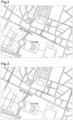
- FIG. 2 illustrates the result of a calculation of primary indices on a district of Paris using the GPS autonomy function.
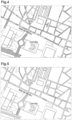
- the value of the primary index is illustrated for four decreasing values by the following signs: + sign, thin hatching, thick hatching, small circles.
- FIG. 5 illustrates the result of a weighted average calculation from the three previous ones. It can be seen that the quality of the GPS index on a part of the rue de Rivoli is partially deteriorated by the other autonomy functions. A correction can however be made with a CIN autonomy function. It should be noted in this regard that the quality of the index depends on the quality of the components used. In particular, a good quality CIN would make it possible to move all sections of the journey to the higher value. The quality of the components combined with the method of the invention will therefore make it possible to distinguish between vehicles truly equipped for autonomous navigation, and those which are only autonomous in specific circumstances.
- the autonomous vehicle enabling the implementation of the method of the invention comprises an automatic piloting unit and a navigation unit.
- the automatic piloting unit is connected to the vehicle's control components such as the steering system, the engine, the braking system, as well as to sensors for detecting the vehicle's behavior and the vehicle's environment. vehicle, and incorporates calculation means for controlling the control members based on the information provided by the sensors so that the vehicle remains on a determined trajectory while complying with road regulations.
- the navigation unit comprises, for example, a GPS module and a route planning module based on cartographic data including the autonomy map.
- the autonomy map is used both by the navigation unit to determine a route according to the index of the sections taken and by the control unit which will determine, depending on the section taken, which sensors it will prioritize (for example, in an area where GPS signal reception is of poor quality, the GPS information will be neglected for controlling the vehicle so as to limit the risk that taking this information into account will impair the accuracy of autonomous control).
- Autonomy maps can be used to advantage by an organization managing the road network to identify sections of its network that need to be improved for the circulation of autonomous vehicles (by redoing road signs, installing RFID tags to provide information to autonomous vehicles, etc.).
- Autonomy maps can be used to advantage by car manufacturers to help them determine how much of the network their vehicles can operate autonomously on and to improve their vehicles by helping them identify which sensors should be fitted to autonomous vehicles to enable autonomous driving on a larger part of the network.
- the autonomy of a vehicle depends on the sensors present on the vehicle. Consequently, an autonomy map will be developed for each model, or even version, of a vehicle. It will also be possible to provide organizations managing the road network at the local or national level with "global" autonomy maps corresponding to several types or models of autonomous vehicles. For example, a "minimum” autonomy map could be established based on the minimum equipment of autonomous vehicles and a “maximum” autonomy map based on the maximum equipment of autonomous vehicles.
Landscapes
- Engineering & Computer Science (AREA)
- Radar, Positioning & Navigation (AREA)
- Remote Sensing (AREA)
- Automation & Control Theory (AREA)
- Physics & Mathematics (AREA)
- General Physics & Mathematics (AREA)
- Aviation & Aerospace Engineering (AREA)
- Business, Economics & Management (AREA)
- Health & Medical Sciences (AREA)
- Artificial Intelligence (AREA)
- Evolutionary Computation (AREA)
- Game Theory and Decision Science (AREA)
- Medical Informatics (AREA)
- Navigation (AREA)
- Traffic Control Systems (AREA)
Claims (8)
- Verfahren zur Erstellung einer Karte für die autonome Navigation eines autonomen Fahrzeugs, das mit zumindest zwei Sensoren ausgestattet ist, die jeweils eine separate Funktion zur autonomen Navigation in einer Zone mit Streckenabschnitten bereitstellen, wobei das Verfahren die folgenden Schritte enthält: das Identifizieren (1) jener Streckenabschnitte, für welche die Karte erstellt werden soll; das für jeden Streckenabschnitt erfolgende Berechnen (3) eines primären Autonomiekennwerts für jede der Funktionen zur autonomen Navigation; und das für jeden Streckenabschnitt erfolgende Berechnen (4) eines finalen Autonomiekennwerts aus den primären Autonomiekennwerten, dadurch gekennzeichnet, dass der finale Autonomiekennwert berechnet wird, indem aus den primären Autonomiekennwerten gemäß einer relativen Bedeutung jedes primären Kennwerts ein gewogener Mittelwert für die autonome Navigation des Fahrzeugs gewonnen wird.
- Verfahren nach Anspruch 1, umfassend die folgenden Schritte: das Durchführen mehrerer Berechnungen (4) jedes finalen Kennwerts mit separaten Gewichtungsfaktoren; das Vergleichen (5) der gewonnenen finalen Autonomiekennwerte; und das Erstellen (6) der Karte für die autonome Navigation, indem jeweils jene Gewichtung gewählt wird, bei welcher der niedrigste finale Kennwert der ausgeprägteste unter den niedrigsten finalen Kennwerten für die verschiedenen Gewichtungen ist.
- Verfahren nach Anspruch 1, umfassend die folgenden Schritte: das Durchführen mehrerer Berechnungen (4) jedes finalen Kennwerts mit separaten Gewichtungsfaktoren; das Vergleichen (5) der gewonnenen finalen Autonomiekennwerte; und das Erstellen der Karte für die autonome Navigation, indem für jeden Streckenabschnitt der höchste finale Autonomiekennwert gewählt wird.
- Verfahren nach Anspruch 1, dadurch gekennzeichnet, dass es die folgenden Schritte umfasst: das Identifizieren jener Streckenabschnitte, in welchen die finalen Autonomiekennwerte unter einem vorbestimmten Schwellenwert liegen, und das Durchführen eines Glättungsvorgangs (7), der auf die unmittelbar benachbarten Streckenabschnitte angewendet wird.
- Verfahren nach Anspruch 1, dadurch gekennzeichnet, dass es den Vorbereitungsschritt umfasst, die Beschaffenheit der Streckenabschnitte zu analysieren (1) und Einrichtungen einzusetzen, die dafür angepasst sind, die primären Autonomiekennwerte zu verbessern.
- Karte für die autonome Navigation eines autonomen Fahrzeugs in einer Zone mit Streckenabschnitten, welche gemäß dem Verfahren nach Anspruch 1 erstellt worden ist, dadurch gekennzeichnet, dass sie für jeden Streckenabschnitt einen finalen Autonomiekennwert enthält, welcher gewonnen wird, indem ein gewogener Mittelwert aus primären Autonomiekennwerten basierend auf zumindest zwei separaten Autonomiefunktionen ermittelt wird, die jeweils durch einen Fahrzeugsensor bereitgestellt werden.
- Anwendung einer Karte für die autonome Navigation nach Anspruch 6 auf die Bestimmung einer Strecke, dadurch gekennzeichnet, dass den geografischen Parametern zur Streckenbestimmung Autonomieparameter hinzugefügt werden.
- Autonomes Fahrzeug mit einer Autopiloteinheit und einer Navigationseinheit, wobei die Autopiloteinheit mit Bedienelementen des Fahrzeugs sowie mit Sensoren zur Erfassung des Fahrzeugverhaltens und der Fahrzeugumgebung verbunden ist und Berechnungsmittel aufweist, die dazu dienen, die Bedienorgane anhand der von den Sensoren bereitgestellten Informationen derart anzusteuern, dass das Fahrzeug unter Beachtung der Verkehrsvorschriften auf einem vorbestimmten Streckenverlauf bleibt; wobei die Navigationseinheit ein Modul zur Planung von Routen anhand von Kartendaten aufweist, die eine Karte für die autonome Navigation nach Anspruch 6 umfassen, wobei die Karte für die autonome Navigation doppelt ausgewertet wird, und zwar sowohl von der Navigationseinheit zur Bestimmung einer Route basierend auf dem finalen Autonomiekennwert des jeweils befahrenen Streckenabschnitts, als auch von der Autopiloteinheit zur Bestimmung der je nach befahrenem Streckenabschnitt bevorzugt zu verwendenden Sensoren.
Applications Claiming Priority (2)
| Application Number | Priority Date | Filing Date | Title |
|---|---|---|---|
| FR1660599A FR3058214B1 (fr) | 2016-11-02 | 2016-11-02 | Procede d'elaboration d'une carte d'autonomie de navigation pour un vehicule |
| PCT/EP2017/078101 WO2018083200A1 (fr) | 2016-11-02 | 2017-11-02 | Procédé d`élaboration d`une carte d`autonomie de navigation pour un véhicule |
Publications (2)
| Publication Number | Publication Date |
|---|---|
| EP3535546A1 EP3535546A1 (de) | 2019-09-11 |
| EP3535546B1 true EP3535546B1 (de) | 2025-06-11 |
Family
ID=59030990
Family Applications (1)
| Application Number | Title | Priority Date | Filing Date |
|---|---|---|---|
| EP17797117.3A Active EP3535546B1 (de) | 2016-11-02 | 2017-11-02 | Verfahren zur erstellung einer autonomen navigationskarte für ein fahrzeug |
Country Status (6)
| Country | Link |
|---|---|
| US (1) | US11703347B2 (de) |
| EP (1) | EP3535546B1 (de) |
| CN (1) | CN110114635B (de) |
| FR (1) | FR3058214B1 (de) |
| IL (1) | IL266384B2 (de) |
| WO (1) | WO2018083200A1 (de) |
Families Citing this family (9)
| Publication number | Priority date | Publication date | Assignee | Title |
|---|---|---|---|---|
| US11359926B2 (en) * | 2018-09-27 | 2022-06-14 | Intel Corporation | Technologies for autonomous driving quality of service determination and communication |
| US12078993B2 (en) * | 2019-05-09 | 2024-09-03 | ANI Technologies Private Limited | Generation of autonomy map for autonomous vehicle |
| US11713979B2 (en) | 2020-08-27 | 2023-08-01 | Here Global B.V. | Method, apparatus, and computer program product for generating a transition variability index related to autonomous driving |
| US11687094B2 (en) | 2020-08-27 | 2023-06-27 | Here Global B.V. | Method, apparatus, and computer program product for organizing autonomous vehicles in an autonomous transition region |
| US20220065656A1 (en) * | 2020-08-27 | 2022-03-03 | Here Global B.V. | Method, apparatus, and computer program product for generating an automated driving capability map index |
| US11691643B2 (en) | 2020-08-27 | 2023-07-04 | Here Global B.V. | Method and apparatus to improve interaction models and user experience for autonomous driving in transition regions |
| CN114248759B (zh) * | 2020-09-24 | 2023-12-08 | 丰田自动车株式会社 | 混合动力车辆的控制装置及控制方法 |
| JP7260575B2 (ja) * | 2021-02-25 | 2023-04-18 | 本田技研工業株式会社 | 地図生成装置 |
| US12233915B2 (en) * | 2022-07-19 | 2025-02-25 | Hitachi, Ltd. | Allocating resources for a vehicle |
Family Cites Families (13)
| Publication number | Priority date | Publication date | Assignee | Title |
|---|---|---|---|---|
| US8775063B2 (en) * | 2009-01-26 | 2014-07-08 | GM Global Technology Operations LLC | System and method of lane path estimation using sensor fusion |
| FR2981778B1 (fr) * | 2011-10-24 | 2013-12-13 | Airbus Operations Sas | Procede et dispositif d'atterrissage automatique d'un aeronef sur une piste a forte pente. |
| US9188985B1 (en) * | 2012-09-28 | 2015-11-17 | Google Inc. | Suggesting a route based on desired amount of driver interaction |
| EP2972096B1 (de) * | 2013-03-15 | 2019-01-09 | Volkswagen Aktiengesellschaft | Anwendung zum planen einer automatisch befahrbaren route |
| US9103688B2 (en) * | 2013-08-21 | 2015-08-11 | Continental Automotive Systems, Inc. | Adapting vehicle personality using analyzed driver performance metrics |
| US10354330B1 (en) * | 2014-05-20 | 2019-07-16 | State Farm Mutual Automobile Insurance Company | Autonomous feature use monitoring and insurance pricing |
| CN111380545B (zh) * | 2015-02-10 | 2024-11-12 | 御眼视觉技术有限公司 | 用于自主车辆导航的方法、服务器、自主车辆以及介质 |
| US9688288B1 (en) * | 2016-03-08 | 2017-06-27 | VOLKSWAGEN AG et al. | Geofencing for auto drive route planning |
| US20170356748A1 (en) * | 2016-06-14 | 2017-12-14 | nuTonomy Inc. | Route Planning for an Autonomous Vehicle |
| US11092446B2 (en) * | 2016-06-14 | 2021-08-17 | Motional Ad Llc | Route planning for an autonomous vehicle |
| US10438493B2 (en) * | 2016-08-24 | 2019-10-08 | Uber Technologies, Inc. | Hybrid trip planning for autonomous vehicles |
| US10710603B2 (en) * | 2016-10-19 | 2020-07-14 | Here Global B.V. | Segment activity planning based on route characteristics |
| US10126137B2 (en) * | 2017-02-09 | 2018-11-13 | GM Global Technology Operations LLC | Methods and systems to convey autonomous/semi-autonomous feature available roadways |
-
2016
- 2016-11-02 FR FR1660599A patent/FR3058214B1/fr active Active
-
2017
- 2017-11-02 WO PCT/EP2017/078101 patent/WO2018083200A1/fr not_active Ceased
- 2017-11-02 US US16/347,151 patent/US11703347B2/en active Active
- 2017-11-02 CN CN201780068460.XA patent/CN110114635B/zh active Active
- 2017-11-02 EP EP17797117.3A patent/EP3535546B1/de active Active
- 2017-11-02 IL IL266384A patent/IL266384B2/en unknown
Also Published As
| Publication number | Publication date |
|---|---|
| CN110114635B (zh) | 2023-12-29 |
| FR3058214A1 (fr) | 2018-05-04 |
| CN110114635A (zh) | 2019-08-09 |
| US20200057451A1 (en) | 2020-02-20 |
| IL266384A (en) | 2019-06-30 |
| IL266384B2 (en) | 2024-01-01 |
| WO2018083200A1 (fr) | 2018-05-11 |
| IL266384B1 (en) | 2023-09-01 |
| US11703347B2 (en) | 2023-07-18 |
| FR3058214B1 (fr) | 2020-06-12 |
| EP3535546A1 (de) | 2019-09-11 |
Similar Documents
| Publication | Publication Date | Title |
|---|---|---|
| EP3535546B1 (de) | Verfahren zur erstellung einer autonomen navigationskarte für ein fahrzeug | |
| US9796388B2 (en) | Vehicle mode determination | |
| US12058552B2 (en) | Systems and methods for selecting locations to validate automated vehicle data transmission | |
| US11499833B2 (en) | Inferring lane boundaries via high speed vehicle telemetry | |
| US20200103919A1 (en) | Method and device for operating a vehicle | |
| US12202514B2 (en) | Method for evaluating route sections | |
| US11852742B2 (en) | Method for generating a map of the surroundings of a vehicle | |
| EP4011736B1 (de) | Verfahren und vorrichtung für autonomes fahren im gemischten fahrmodus | |
| US20230166761A1 (en) | Method and system for estimation of an operational design domain boundary | |
| US9726509B1 (en) | Profile aware navigation | |
| EP3792127B1 (de) | Verfahren zur unterstützung bei der wahl der positionierung eines fahrzeugs auf einer strasse mit einer vielzahl von fahrspuren | |
| US20220340145A1 (en) | Automatic recommendation of control in a simultaneous mix mode vehicle | |
| US20210048819A1 (en) | Apparatus and method for determining junction | |
| US20250128729A1 (en) | Method for managing a user demand-based operational design domain expansion for an automated driving system of a vehicle | |
| FR3098777A1 (fr) | Procédé d’insertion dans un convoi de véhicules autonomes par un véhicule automobile | |
| CN119907902A (zh) | 用于自动驾驶的车辆的路线规划的方法和系统 | |
| CN117858827A (zh) | 一种车辆的控制方法、装置、车辆、程序产品及存储介质 | |
| CN117730289A (zh) | 测试方法及装置 | |
| US20260001573A1 (en) | Method for evaluating a candidate automated driving feature | |
| FR3079804A1 (fr) | Procede et systeme d'assistance au conducteur d'un vehicule automobile muni d'un systeme d'aide a la conduite | |
| Li et al. | A Path Planning Method Based on Large Amount of Artificial Driving Trajectories | |
| CN116977954A (zh) | 车道定位的方法、装置、设备以及存储介质 | |
| FR3157320A1 (fr) | Procédé et dispositif de contrôle d’un système de détermination d’une position d’un véhicule sur une route | |
| CN117360511A (zh) | 用于运行机动车的方法以及机动车 | |
| CN120239828A (zh) | 用于状态假设的融合的方法和装置 |
Legal Events
| Date | Code | Title | Description |
|---|---|---|---|
| STAA | Information on the status of an ep patent application or granted ep patent |
Free format text: STATUS: UNKNOWN |
|
| STAA | Information on the status of an ep patent application or granted ep patent |
Free format text: STATUS: THE INTERNATIONAL PUBLICATION HAS BEEN MADE |
|
| PUAI | Public reference made under article 153(3) epc to a published international application that has entered the european phase |
Free format text: ORIGINAL CODE: 0009012 |
|
| STAA | Information on the status of an ep patent application or granted ep patent |
Free format text: STATUS: REQUEST FOR EXAMINATION WAS MADE |
|
| 17P | Request for examination filed |
Effective date: 20190528 |
|
| AK | Designated contracting states |
Kind code of ref document: A1 Designated state(s): AL AT BE BG CH CY CZ DE DK EE ES FI FR GB GR HR HU IE IS IT LI LT LU LV MC MK MT NL NO PL PT RO RS SE SI SK SM TR |
|
| AX | Request for extension of the european patent |
Extension state: BA ME |
|
| DAV | Request for validation of the european patent (deleted) | ||
| DAX | Request for extension of the european patent (deleted) | ||
| STAA | Information on the status of an ep patent application or granted ep patent |
Free format text: STATUS: EXAMINATION IS IN PROGRESS |
|
| 17Q | First examination report despatched |
Effective date: 20200221 |
|
| RIC1 | Information provided on ipc code assigned before grant |
Ipc: G01C 21/32 20060101AFI20250124BHEP |
|
| GRAP | Despatch of communication of intention to grant a patent |
Free format text: ORIGINAL CODE: EPIDOSNIGR1 |
|
| STAA | Information on the status of an ep patent application or granted ep patent |
Free format text: STATUS: GRANT OF PATENT IS INTENDED |
|
| INTG | Intention to grant announced |
Effective date: 20250313 |
|
| GRAS | Grant fee paid |
Free format text: ORIGINAL CODE: EPIDOSNIGR3 |
|
| GRAA | (expected) grant |
Free format text: ORIGINAL CODE: 0009210 |
|
| STAA | Information on the status of an ep patent application or granted ep patent |
Free format text: STATUS: THE PATENT HAS BEEN GRANTED |
|
| AK | Designated contracting states |
Kind code of ref document: B1 Designated state(s): AL AT BE BG CH CY CZ DE DK EE ES FI FR GB GR HR HU IE IS IT LI LT LU LV MC MK MT NL NO PL PT RO RS SE SI SK SM TR |
|
| REG | Reference to a national code |
Ref country code: GB Ref legal event code: FG4D Free format text: NOT ENGLISH |
|
| REG | Reference to a national code |
Ref country code: CH Ref legal event code: EP |
|
| REG | Reference to a national code |
Ref country code: DE Ref legal event code: R096 Ref document number: 602017089912 Country of ref document: DE |
|
| REG | Reference to a national code |
Ref country code: IE Ref legal event code: FG4D Free format text: LANGUAGE OF EP DOCUMENT: FRENCH |
|
| PG25 | Lapsed in a contracting state [announced via postgrant information from national office to epo] |
Ref country code: FI Free format text: LAPSE BECAUSE OF FAILURE TO SUBMIT A TRANSLATION OF THE DESCRIPTION OR TO PAY THE FEE WITHIN THE PRESCRIBED TIME-LIMIT Effective date: 20250611 Ref country code: ES Free format text: LAPSE BECAUSE OF FAILURE TO SUBMIT A TRANSLATION OF THE DESCRIPTION OR TO PAY THE FEE WITHIN THE PRESCRIBED TIME-LIMIT Effective date: 20250611 |
|
| REG | Reference to a national code |
Ref country code: LT Ref legal event code: MG9D |
|
| PG25 | Lapsed in a contracting state [announced via postgrant information from national office to epo] |
Ref country code: NO Free format text: LAPSE BECAUSE OF FAILURE TO SUBMIT A TRANSLATION OF THE DESCRIPTION OR TO PAY THE FEE WITHIN THE PRESCRIBED TIME-LIMIT Effective date: 20250911 Ref country code: GR Free format text: LAPSE BECAUSE OF FAILURE TO SUBMIT A TRANSLATION OF THE DESCRIPTION OR TO PAY THE FEE WITHIN THE PRESCRIBED TIME-LIMIT Effective date: 20250912 |
|
| REG | Reference to a national code |
Ref country code: NL Ref legal event code: MP Effective date: 20250611 |
|
| PG25 | Lapsed in a contracting state [announced via postgrant information from national office to epo] |
Ref country code: BG Free format text: LAPSE BECAUSE OF FAILURE TO SUBMIT A TRANSLATION OF THE DESCRIPTION OR TO PAY THE FEE WITHIN THE PRESCRIBED TIME-LIMIT Effective date: 20250611 |
|
| PG25 | Lapsed in a contracting state [announced via postgrant information from national office to epo] |
Ref country code: HR Free format text: LAPSE BECAUSE OF FAILURE TO SUBMIT A TRANSLATION OF THE DESCRIPTION OR TO PAY THE FEE WITHIN THE PRESCRIBED TIME-LIMIT Effective date: 20250611 |
|
| PG25 | Lapsed in a contracting state [announced via postgrant information from national office to epo] |
Ref country code: RS Free format text: LAPSE BECAUSE OF FAILURE TO SUBMIT A TRANSLATION OF THE DESCRIPTION OR TO PAY THE FEE WITHIN THE PRESCRIBED TIME-LIMIT Effective date: 20250911 |
|
| PG25 | Lapsed in a contracting state [announced via postgrant information from national office to epo] |
Ref country code: LV Free format text: LAPSE BECAUSE OF FAILURE TO SUBMIT A TRANSLATION OF THE DESCRIPTION OR TO PAY THE FEE WITHIN THE PRESCRIBED TIME-LIMIT Effective date: 20250611 |
|
| PG25 | Lapsed in a contracting state [announced via postgrant information from national office to epo] |
Ref country code: NL Free format text: LAPSE BECAUSE OF FAILURE TO SUBMIT A TRANSLATION OF THE DESCRIPTION OR TO PAY THE FEE WITHIN THE PRESCRIBED TIME-LIMIT Effective date: 20250611 |
|
| PG25 | Lapsed in a contracting state [announced via postgrant information from national office to epo] |
Ref country code: PT Free format text: LAPSE BECAUSE OF FAILURE TO SUBMIT A TRANSLATION OF THE DESCRIPTION OR TO PAY THE FEE WITHIN THE PRESCRIBED TIME-LIMIT Effective date: 20251013 |
|
| REG | Reference to a national code |
Ref country code: AT Ref legal event code: MK05 Ref document number: 1802582 Country of ref document: AT Kind code of ref document: T Effective date: 20250611 |
|
| PG25 | Lapsed in a contracting state [announced via postgrant information from national office to epo] |
Ref country code: IS Free format text: LAPSE BECAUSE OF FAILURE TO SUBMIT A TRANSLATION OF THE DESCRIPTION OR TO PAY THE FEE WITHIN THE PRESCRIBED TIME-LIMIT Effective date: 20251011 |
|
| PGFP | Annual fee paid to national office [announced via postgrant information from national office to epo] |
Ref country code: DE Payment date: 20251118 Year of fee payment: 9 |
|
| PGFP | Annual fee paid to national office [announced via postgrant information from national office to epo] |
Ref country code: GB Payment date: 20251125 Year of fee payment: 9 |
|
| PG25 | Lapsed in a contracting state [announced via postgrant information from national office to epo] |
Ref country code: SM Free format text: LAPSE BECAUSE OF FAILURE TO SUBMIT A TRANSLATION OF THE DESCRIPTION OR TO PAY THE FEE WITHIN THE PRESCRIBED TIME-LIMIT Effective date: 20250611 Ref country code: AT Free format text: LAPSE BECAUSE OF FAILURE TO SUBMIT A TRANSLATION OF THE DESCRIPTION OR TO PAY THE FEE WITHIN THE PRESCRIBED TIME-LIMIT Effective date: 20250611 |
|
| PGFP | Annual fee paid to national office [announced via postgrant information from national office to epo] |
Ref country code: FR Payment date: 20251125 Year of fee payment: 9 |
|
| PG25 | Lapsed in a contracting state [announced via postgrant information from national office to epo] |
Ref country code: CZ Free format text: LAPSE BECAUSE OF FAILURE TO SUBMIT A TRANSLATION OF THE DESCRIPTION OR TO PAY THE FEE WITHIN THE PRESCRIBED TIME-LIMIT Effective date: 20250611 |
|
| PG25 | Lapsed in a contracting state [announced via postgrant information from national office to epo] |
Ref country code: PL Free format text: LAPSE BECAUSE OF FAILURE TO SUBMIT A TRANSLATION OF THE DESCRIPTION OR TO PAY THE FEE WITHIN THE PRESCRIBED TIME-LIMIT Effective date: 20250611 |
|
| PG25 | Lapsed in a contracting state [announced via postgrant information from national office to epo] |
Ref country code: EE Free format text: LAPSE BECAUSE OF FAILURE TO SUBMIT A TRANSLATION OF THE DESCRIPTION OR TO PAY THE FEE WITHIN THE PRESCRIBED TIME-LIMIT Effective date: 20250611 |
|
| PG25 | Lapsed in a contracting state [announced via postgrant information from national office to epo] |
Ref country code: RO Free format text: LAPSE BECAUSE OF FAILURE TO SUBMIT A TRANSLATION OF THE DESCRIPTION OR TO PAY THE FEE WITHIN THE PRESCRIBED TIME-LIMIT Effective date: 20250611 Ref country code: SK Free format text: LAPSE BECAUSE OF FAILURE TO SUBMIT A TRANSLATION OF THE DESCRIPTION OR TO PAY THE FEE WITHIN THE PRESCRIBED TIME-LIMIT Effective date: 20250611 |
|
| REG | Reference to a national code |
Ref country code: DE Ref legal event code: R097 Ref document number: 602017089912 Country of ref document: DE |
|
| PG25 | Lapsed in a contracting state [announced via postgrant information from national office to epo] |
Ref country code: DK Free format text: LAPSE BECAUSE OF FAILURE TO SUBMIT A TRANSLATION OF THE DESCRIPTION OR TO PAY THE FEE WITHIN THE PRESCRIBED TIME-LIMIT Effective date: 20250611 |
|
| PG25 | Lapsed in a contracting state [announced via postgrant information from national office to epo] |
Ref country code: IT Free format text: LAPSE BECAUSE OF FAILURE TO SUBMIT A TRANSLATION OF THE DESCRIPTION OR TO PAY THE FEE WITHIN THE PRESCRIBED TIME-LIMIT Effective date: 20250611 |
|
| PLBE | No opposition filed within time limit |
Free format text: ORIGINAL CODE: 0009261 |
|
| STAA | Information on the status of an ep patent application or granted ep patent |
Free format text: STATUS: NO OPPOSITION FILED WITHIN TIME LIMIT |
|
| REG | Reference to a national code |
Ref country code: CH Ref legal event code: L10 Free format text: ST27 STATUS EVENT CODE: U-0-0-L10-L00 (AS PROVIDED BY THE NATIONAL OFFICE) Effective date: 20260423 |