EP3535546B1 - Method for producing an autonomous navigation map for a vehicle - Google Patents
Method for producing an autonomous navigation map for a vehicle Download PDFInfo
- Publication number
- EP3535546B1 EP3535546B1 EP17797117.3A EP17797117A EP3535546B1 EP 3535546 B1 EP3535546 B1 EP 3535546B1 EP 17797117 A EP17797117 A EP 17797117A EP 3535546 B1 EP3535546 B1 EP 3535546B1
- Authority
- EP
- European Patent Office
- Prior art keywords
- autonomy
- indices
- final
- map
- navigation
- Prior art date
- Legal status (The legal status is an assumption and is not a legal conclusion. Google has not performed a legal analysis and makes no representation as to the accuracy of the status listed.)
- Active
Links
Images

Classifications
-
- G—PHYSICS
- G01—MEASURING; TESTING
- G01C—MEASURING DISTANCES, LEVELS OR BEARINGS; SURVEYING; NAVIGATION; GYROSCOPIC INSTRUMENTS; PHOTOGRAMMETRY OR VIDEOGRAMMETRY
- G01C21/00—Navigation; Navigational instruments not provided for in groups G01C1/00 - G01C19/00
- G01C21/26—Navigation; Navigational instruments not provided for in groups G01C1/00 - G01C19/00 specially adapted for navigation in a road network
- G01C21/28—Navigation; Navigational instruments not provided for in groups G01C1/00 - G01C19/00 specially adapted for navigation in a road network with correlation of data from several navigational instruments
- G01C21/30—Map- or contour-matching
- G01C21/32—Structuring or formatting of map data
-
- G—PHYSICS
- G01—MEASURING; TESTING
- G01C—MEASURING DISTANCES, LEVELS OR BEARINGS; SURVEYING; NAVIGATION; GYROSCOPIC INSTRUMENTS; PHOTOGRAMMETRY OR VIDEOGRAMMETRY
- G01C21/00—Navigation; Navigational instruments not provided for in groups G01C1/00 - G01C19/00
- G01C21/38—Electronic maps specially adapted for navigation; Updating thereof
- G01C21/3804—Creation or updating of map data
- G01C21/3807—Creation or updating of map data characterised by the type of data
- G01C21/3815—Road data
-
- G—PHYSICS
- G01—MEASURING; TESTING
- G01C—MEASURING DISTANCES, LEVELS OR BEARINGS; SURVEYING; NAVIGATION; GYROSCOPIC INSTRUMENTS; PHOTOGRAMMETRY OR VIDEOGRAMMETRY
- G01C21/00—Navigation; Navigational instruments not provided for in groups G01C1/00 - G01C19/00
- G01C21/38—Electronic maps specially adapted for navigation; Updating thereof
- G01C21/3804—Creation or updating of map data
- G01C21/3833—Creation or updating of map data characterised by the source of data
- G01C21/3844—Data obtained from position sensors only, e.g. from inertial navigation
-
- G—PHYSICS
- G05—CONTROLLING; REGULATING
- G05D—SYSTEMS FOR CONTROLLING OR REGULATING NON-ELECTRIC VARIABLES
- G05D1/00—Control of position, course, altitude or attitude of land, water, air or space vehicles, e.g. using automatic pilots
- G05D1/0088—Control of position, course, altitude or attitude of land, water, air or space vehicles, e.g. using automatic pilots characterized by the autonomous decision making process, e.g. artificial intelligence, predefined behaviours
-
- G—PHYSICS
- G05—CONTROLLING; REGULATING
- G05D—SYSTEMS FOR CONTROLLING OR REGULATING NON-ELECTRIC VARIABLES
- G05D1/00—Control of position, course, altitude or attitude of land, water, air or space vehicles, e.g. using automatic pilots
- G05D1/02—Control of position or course in two dimensions
- G05D1/021—Control of position or course in two dimensions specially adapted to land vehicles
- G05D1/0268—Control of position or course in two dimensions specially adapted to land vehicles using internal positioning means
- G05D1/0274—Control of position or course in two dimensions specially adapted to land vehicles using internal positioning means using mapping information stored in a memory device
Definitions
- the present invention relates to a method for developing a navigation autonomy map for a vehicle, the autonomy map obtained and an application of this map to determining a route.
- GPS abbreviation for Global Positioning System
- GPS Global System for Mobile Communications
- LIDAR acronym for Light Detection And Ranging
- LADAR acronym for Laser Detection And Ranging
- INS abbreviated from the English expression Inertial Navigation System, or in French CIN for Centrale Inertielle de Navigation
- techniques using the detection of road markings techniques exploiting the emission of dedicated signals by transmitters placed in road infrastructure equipment, in particular traffic lights.
- WO 2014/139821 A1 discloses that a final autonomy index (PA) is calculated from a simple sum of the primary autonomy indices calculated for each journey segment according to at least two distinct navigation autonomy functions.
- An aim of the invention is to propose a method for developing a navigation autonomy map for a vehicle, which is reliable over all sections of the journey in a given area.
- the invention proposes a method for developing a navigation autonomy map for an autonomous vehicle, according to claim 1.
- the autonomy map thus groups together specific cartographic data such as the indices autonomy which will increase security autonomous vehicles, for example, by making it possible to plan journeys whose sections are assigned the most favorable autonomy indices.
- the final autonomy index is calculated by performing a weighted average of the primary autonomy indices and the method comprises the steps of: performing several calculations of each final index with distinct weighting coefficients; comparing the final autonomy indices obtained; and developing the navigation autonomy map by retaining the weighting for which the lowest final index is the strongest of the lowest final indices of the different weightings.
- the method comprises the steps of: identifying journey sections for which the final autonomy indices are lower than a predetermined threshold, and performing smoothing on the immediately adjacent journey sections.
- the method comprises the prior step of analyzing the configuration of the journey sections and installing equipment suitable for improving the primary autonomy indices.
- the invention also relates to: a navigation autonomy map for an autonomous vehicle in an area comprising journey sections, in which, for each journey section, the map includes a final autonomy index obtained by performing a weighted average of primary autonomy indices according to at least two distinct autonomy functions; and an application of this autonomy map to the determination of a journey obtained by adding autonomy parameters to the different parameters (speed, existence of tolls, etc.) which are currently used to determine a journey.
- the illustrated method comprises a first step 1 of analysis of the configuration of the journey sections, followed by a choice 2 of the autonomy functions.
- a choice 2 of the autonomy functions For example, for a city of In a very closed structure, with very close buildings, and heavily equipped with ground markings and dedicated transmitters located in city facilities, the corresponding recognition parameters will be chosen, while on a road in open country the GPS autonomy function will be chosen.
- the weighting coefficients correspond to the relative importance of each primary index for the autonomy of the vehicle (for example, in a given section, having precise road markings and high-definition mapping may be more important than having a visual reference point in line of sight).
- the weighting coefficients can be determined a priori or be updated periodically or in real time according to traffic conditions (climatic event such as fog, presence of an accident or roadworks).
- the weighted average can be a constrained weighted average (in this case, we consider that when the primary index is lower than a value X, the coefficient associated with it is worth 0, while when the primary index is higher than the value X, the coefficient is worth 1). For example, assuming that the law prohibits autonomous circulation when the markings are erased, the use of the weighted average under constraint would make it possible to make the criterion relating to road markings preponderant over the others when the road markings are absent.
- a new calculation of the final indices is preferably carried out with a different weighting, followed by a comparison 5 and a selection 6, followed where appropriate by smoothing 7, for example by using an inertial navigation unit.
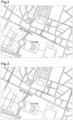
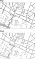
- FIG. 2 illustrates the result of a calculation of primary indices on a district of Paris using the GPS autonomy function.
- the value of the primary index is illustrated for four decreasing values by the following signs: + sign, thin hatching, thick hatching, small circles.
- FIG. 5 illustrates the result of a weighted average calculation from the three previous ones. It can be seen that the quality of the GPS index on a part of the rue de Rivoli is partially deteriorated by the other autonomy functions. A correction can however be made with a CIN autonomy function. It should be noted in this regard that the quality of the index depends on the quality of the components used. In particular, a good quality CIN would make it possible to move all sections of the journey to the higher value. The quality of the components combined with the method of the invention will therefore make it possible to distinguish between vehicles truly equipped for autonomous navigation, and those which are only autonomous in specific circumstances.
- the autonomous vehicle enabling the implementation of the method of the invention comprises an automatic piloting unit and a navigation unit.
- the automatic piloting unit is connected to the vehicle's control components such as the steering system, the engine, the braking system, as well as to sensors for detecting the vehicle's behavior and the vehicle's environment. vehicle, and incorporates calculation means for controlling the control members based on the information provided by the sensors so that the vehicle remains on a determined trajectory while complying with road regulations.
- the navigation unit comprises, for example, a GPS module and a route planning module based on cartographic data including the autonomy map.
- the autonomy map is used both by the navigation unit to determine a route according to the index of the sections taken and by the control unit which will determine, depending on the section taken, which sensors it will prioritize (for example, in an area where GPS signal reception is of poor quality, the GPS information will be neglected for controlling the vehicle so as to limit the risk that taking this information into account will impair the accuracy of autonomous control).
- Autonomy maps can be used to advantage by an organization managing the road network to identify sections of its network that need to be improved for the circulation of autonomous vehicles (by redoing road signs, installing RFID tags to provide information to autonomous vehicles, etc.).
- Autonomy maps can be used to advantage by car manufacturers to help them determine how much of the network their vehicles can operate autonomously on and to improve their vehicles by helping them identify which sensors should be fitted to autonomous vehicles to enable autonomous driving on a larger part of the network.
- the autonomy of a vehicle depends on the sensors present on the vehicle. Consequently, an autonomy map will be developed for each model, or even version, of a vehicle. It will also be possible to provide organizations managing the road network at the local or national level with "global" autonomy maps corresponding to several types or models of autonomous vehicles. For example, a "minimum” autonomy map could be established based on the minimum equipment of autonomous vehicles and a “maximum” autonomy map based on the maximum equipment of autonomous vehicles.
Landscapes
- Engineering & Computer Science (AREA)
- Radar, Positioning & Navigation (AREA)
- Remote Sensing (AREA)
- Automation & Control Theory (AREA)
- Physics & Mathematics (AREA)
- General Physics & Mathematics (AREA)
- Aviation & Aerospace Engineering (AREA)
- Business, Economics & Management (AREA)
- Artificial Intelligence (AREA)
- Evolutionary Computation (AREA)
- Game Theory and Decision Science (AREA)
- Medical Informatics (AREA)
- Health & Medical Sciences (AREA)
- Navigation (AREA)
- Traffic Control Systems (AREA)
Description
La présente invention concerne un procédé d'élaboration d'une carte d'autonomie de navigation pour un véhicule, la carte d'autonomie obtenue et une application de cette carte à la détermination d'un trajet.The present invention relates to a method for developing a navigation autonomy map for a vehicle, the autonomy map obtained and an application of this map to determining a route.
Les véhicules classiques sont aujourd'hui très largement pourvus d'un système de navigation comprenant des données cartographiques et mettant en œuvre un algorithme de planification d'itinéraire exploitant ces données. Ces systèmes, couramment appelés GPS (abréviation de l'anglais Global Positioning System) ne sont cependant pas conçus pour autoriser à eux-seuls un fonctionnement du véhicule sans conducteur.Conventional vehicles today are widely equipped with a navigation system that includes map data and implements a route planning algorithm that uses this data. These systems, commonly called GPS (abbreviation for Global Positioning System), are not, however, designed to allow driverless vehicle operation on their own.
Or, on sait que d'importants travaux sont menés dans le but de permettre une navigation routière autonome, c'est-à-dire sans l'intervention d'un pilote, des véhicules circulant sur le réseau routier.However, we know that significant work is being carried out with the aim of enabling autonomous road navigation, i.e. without the intervention of a pilot, for vehicles circulating on the road network.
L'apparition des fonctions d'autonomie dans les véhicules pose le problème du risque de défaillance de ces fonctions et de leurs conséquences. Ces fonctions ne fournissent des solutions de navigation/pilotage du véhicule que si toutes les informations extérieures nécessaires sont présentes et bien traitées par le système à bord. Sinon elles sont soit en échec et le pilote doit reprendre la main, soit en erreur, et la reprise en main par le pilote est encore plus délicate.The emergence of autonomous functions in vehicles raises the issue of the risk of failure of these functions and their consequences. These functions only provide navigation/vehicle control solutions if all the necessary external information is present and properly processed by the onboard system. Otherwise, they either fail and the driver must take over, or they make a mistake, and taking over by the driver is even more difficult.
Il existe actuellement différents moyens pour assurer une fonction d'autonomie de navigation d'un véhicule ou tout au moins participer à cette fonction d'autonomie. Les principales techniques existantes à ce jour sont connues sous le nom de : GPS (déjà évoqué plus haut) ; LIDAR, acronyme de Light Detection And Ranging, ou LADAR, acronyme de Laser Detection And Ranging ; INS, abrégé de l'expression anglaise Inertial Navigation System, ou en français CIN pour Centrale Inertielle de Navigation ; les techniques utilisant la détection de marquage au sol ; les techniques exploitant l'émission de signaux dédiés par des émetteurs disposés dans les équipements de l'infrastructure routière, notamment les feux de circulation.There are currently various ways to ensure a vehicle's autonomous navigation function or at least participate in this autonomous function. The main techniques currently available are known as: GPS (already mentioned above); LIDAR, acronym for Light Detection And Ranging, or LADAR, acronym for Laser Detection And Ranging; INS, abbreviated from the English expression Inertial Navigation System, or in French CIN for Centrale Inertielle de Navigation; techniques using the detection of road markings; techniques exploiting the emission of dedicated signals by transmitters placed in road infrastructure equipment, in particular traffic lights.
Aucune de ces techniques n'est satisfaisante pour couvrir à elle seule l'ensemble d'un réseau routier.None of these techniques is satisfactory for covering an entire road network on its own.
Un but de l'invention et de proposer un procédé d'élaboration d'une carte d'autonomie de navigation pour un véhicule, qui soit fiable sur la totalité des tronçons de trajet sur une zone donnée.An aim of the invention is to propose a method for developing a navigation autonomy map for a vehicle, which is reliable over all sections of the journey in a given area.
En vue de la réalisation de ce but, on propose selon l'invention un procédé d'élaboration d'une carte d'autonomie de navigation pour un véhicule autonome, selon la revendication 1.In order to achieve this goal, the invention proposes a method for developing a navigation autonomy map for an autonomous vehicle, according to claim 1.
Ainsi, en choisissant des fonctions d'autonomie complémentaires adaptées à la configuration de la zone considérée, on obtient pour chaque tronçon de trajet un indice final d'autonomie présentant une fiabilité améliorée par rapport à une technique existante. La carte d'autonomie regroupe de la sorte des données cartographiques particulières telles que les indices d'autonomie qui vont permettre d'augmenter la sécurité des véhicules autonomes par exemple en permettant de planifier des trajets dont les tronçons sont affectés des indices d'autonomie les plus favorables à l'autonomie.Thus, by choosing complementary autonomy functions adapted to the configuration of the area considered, we obtain for each section of the journey a final autonomy index presenting improved reliability compared to an existing technique. The autonomy map thus groups together specific cartographic data such as the indices autonomy which will increase security autonomous vehicles, for example, by making it possible to plan journeys whose sections are assigned the most favorable autonomy indices.
Selon une version avantageuse de l'invention, l'indice final d'autonomie est calculé en effectuant une moyenne pondérée des indices primaires d'autonomie et le procédé comprend les étapes : d'effectuer plusieurs calculs de chaque indice final avec des coefficients de pondération distincts ; de comparer les indices finaux d'autonomie obtenus ; et d'élaborer la carte d'autonomie de navigation en retenant la pondération pour laquelle l'indice final le plus faible est le plus fort des indices finaux les plus faibles des différentes pondérations.According to an advantageous version of the invention, the final autonomy index is calculated by performing a weighted average of the primary autonomy indices and the method comprises the steps of: performing several calculations of each final index with distinct weighting coefficients; comparing the final autonomy indices obtained; and developing the navigation autonomy map by retaining the weighting for which the lowest final index is the strongest of the lowest final indices of the different weightings.
Ainsi, on améliore encore la précision de la carte d'autonomie de navigation obtenue.This further improves the accuracy of the resulting navigation autonomy map.
Selon une autre version avantageuse de l'invention, le procédé comprend les étapes: d'effectuer plusieurs calculs de chaque indice final avec des coefficients de pondération distincts; de comparer les indices finaux d'autonomie obtenus ; et d'élaborer la carte d'autonomie de navigation en retenant pour chaque tronçon de trajet l'indice final d'autonomie le plus élevé.According to another advantageous version of the invention, the method comprises the steps of: performing several calculations of each final index with distinct weighting coefficients; comparing the final autonomy indices obtained; and developing the navigation autonomy map by retaining the highest final autonomy index for each section of the journey.
Selon un autre aspect de l'invention, le procédé comprend les étapes: d'identifier des tronçons de trajet pour lesquels les indices finaux d'autonomie sont inférieurs à un seuil prédéterminé, et d'effectuer un lissage aux tronçons de trajet immédiatement adjacents. De préférence, le procédé comprend l'étape préalable d'analyser la configuration des tronçons de trajet et de mettre en place des équipements adaptés à améliorer les indices primaires d'autonomie.According to another aspect of the invention, the method comprises the steps of: identifying journey sections for which the final autonomy indices are lower than a predetermined threshold, and performing smoothing on the immediately adjacent journey sections. Preferably, the method comprises the prior step of analyzing the configuration of the journey sections and installing equipment suitable for improving the primary autonomy indices.
L'invention concerne également : une carte d'autonomie de navigation pour un véhicule autonome sur une zone comprenant des tronçons de trajet, dans laquelle, pour chaque tronçon de trajet, la carte comporte un indice final d'autonomie obtenu en effectuant une moyenne pondérée d'indices primaires d'autonomie selon au moins deux fonctions d'autonomie distinctes ; et une application de cette carte d'autonomie à la détermination d'un trajet obtenu en ajoutant des paramètres d'autonomie aux différents paramètres (rapidité, existence de péages...) qui sont actuellement utilisés pour déterminer un trajet.The invention also relates to: a navigation autonomy map for an autonomous vehicle in an area comprising journey sections, in which, for each journey section, the map includes a final autonomy index obtained by performing a weighted average of primary autonomy indices according to at least two distinct autonomy functions; and an application of this autonomy map to the determination of a journey obtained by adding autonomy parameters to the different parameters (speed, existence of tolls, etc.) which are currently used to determine a journey.
D'autres caractéristiques et avantages de l'invention apparaîtront encore à la lecture de la description qui suit d'un mode de réalisation préféré non limitatif de l'invention en référence aux figures ci-jointes parmi lesquelles:
- La
figure 1 est un diagramme par blocs du procédé selon l'invention, - La
figure 2 est une carte comportant des indices primaires calculés pour une première fonction d'autonomie, - La
figure 3 est une carte comportant des indices primaires calculés pour une deuxième fonction d'autonomie, - La
figure 4 est une carte comportant des indices primaires calculés pour une troisième fonction d'autonomie, - La
figure 5 est une carte comportant des indices finaux, calculés à partir des indices primaires des figures précédentes.
- There
Figure 1 is a block diagram of the method according to the invention, - There
Figure 2 is a map comprising primary indices calculated for a first autonomy function, - There
Figure 3 is a map with primary indices calculated for a second autonomy function, - There
Figure 4 is a map with primary indices calculated for a third autonomy function, - There
Figure 5 is a map with final indices, calculated from the primary indices of the previous figures.
En référence aux figures, le procédé illustré comporte une première étape 1 d'analyse de la configuration des tronçons de trajet, suivi d'un choix 2 des fonctions d'autonomie. Par exemple, pour une ville de structure très fermée, comportant des immeubles très serrés, et fortement équipée en marquages au sol et en émetteurs dédiés disposés dans des équipements de la ville on choisira les paramètres de reconnaissance correspondants, tandis que sur une route en rase campagne on choisira la fonction d'autonomie GPS.With reference to the figures, the illustrated method comprises a first step 1 of analysis of the configuration of the journey sections, followed by a
On effectue ensuite le calcul 3 des indices primaires d'autonomie, suivi du calcul 4 des indices finaux en effectuant une moyenne pondérée des indices primaires. Les coefficients de pondération correspondent à l'importance relative de chaque indice primaire pour l'autonomie du véhicule (par exemple, dans un tronçon donné, le fait d'avoir un marquage au sol précis et une cartographie de haute définition peuvent être plus importants que le fait d'avoir en ligne de vue un point de référence visuel). Les coefficients de pondération peuvent être déterminés a priori ou être mis à jour périodiquement ou en temps réel selon des conditions de circulation (évènement climatique comme le brouillard, présence d'un accident ou de travaux). La moyenne pondérée peut être une moyenne pondérée sous contrainte (dans ce cas, on considère que lorsque l'indice primaire est inférieur à une valeur X, le coefficient qui lui est associé vaut 0, tandis que lorsque l'indice primaire est supérieur à la valeur X, le coefficient vaut 1). Par exemple, en imaginant que la loi interdise la circulation autonome lorsque le marquage est effacé, l'utilisation de la moyenne pondérée sous contrainte permettrait de rendre le critère relatif au marquage au sol prépondérant sur les autres lorsque le marquage au sol est absent.We then perform
Si les indices finaux obtenus n'apparaissent pas suffisamment fiables, on réalise de préférence un nouveau calcul des indices finaux avec une pondération différente, suivi d'une comparaison 5 et d'une sélection 6, suivie le cas échéant d'un lissage 7 par exemple en utilisant une centrale inertielle de navigation.If the final indices obtained do not appear sufficiently reliable, a new calculation of the final indices is preferably carried out with a different weighting, followed by a
La
La
La
La
Le véhicule autonome permettant la mise en œuvre du procédé de l'invention comporte une unité de pilotage automatique et une unité de navigation. L'unité de pilotage automatique est reliée aux organes de commande du véhicule comme le système de direction, le moteur, le système de freinage, ainsi qu'à des capteurs de détection du comportement du véhicule et de l'environnement du véhicule, et incorpore des moyens de calcul permettant de piloter les organes de commande à partir des informations fournies par les capteurs de manière que le véhicule reste sur une trajectoire déterminée en respectant la règlementation routière. L'unité de navigation comprend par exemple un module GPS et un module de planification d'itinéraires à partir de données cartographiques comprenant la carte d'autonomie. La carte d'autonomie est exploitée à la fois par l'unité de navigation pour déterminer un itinéraire selon l'indice des tronçons empruntés et par l'unité de pilotage qui va déterminer, selon le tronçon emprunté, quels capteurs elle va privilégier (par exemple, dans une zone dans laquelle la réception des signaux GPS est de mauvaise qualité, l'information GPS sera négligée pour le pilotage du véhicule de manière à limiter le risque que la prise en compte de cette information ne vienne altérer la précision de pilotage autonome).The autonomous vehicle enabling the implementation of the method of the invention comprises an automatic piloting unit and a navigation unit. The automatic piloting unit is connected to the vehicle's control components such as the steering system, the engine, the braking system, as well as to sensors for detecting the vehicle's behavior and the vehicle's environment. vehicle, and incorporates calculation means for controlling the control members based on the information provided by the sensors so that the vehicle remains on a determined trajectory while complying with road regulations. The navigation unit comprises, for example, a GPS module and a route planning module based on cartographic data including the autonomy map. The autonomy map is used both by the navigation unit to determine a route according to the index of the sections taken and by the control unit which will determine, depending on the section taken, which sensors it will prioritize (for example, in an area where GPS signal reception is of poor quality, the GPS information will be neglected for controlling the vehicle so as to limit the risk that taking this information into account will impair the accuracy of autonomous control).
Les cartes d'autonomie peuvent être avantageusement utilisées par un organisme assurant la gestion du réseau routier pour identifier les tronçons de son réseau qu'il faut améliorer pour la circulation des véhicules autonomes (en refaisant la signalisation au sol, en disposant des balises RFID permettant une information des véhicules autonomes...).Autonomy maps can be used to advantage by an organization managing the road network to identify sections of its network that need to be improved for the circulation of autonomous vehicles (by redoing road signs, installing RFID tags to provide information to autonomous vehicles, etc.).
Les cartes d'autonomie peuvent être avantageusement utilisées par les constructeurs automobiles pour leur permettre de déterminer sur quelle part du réseau leurs véhicules peuvent fonctionner de manière autonome et d'améliorer leurs véhicules en les aidant à identifier quels capteurs doivent équiper les véhicules autonomes pour permettre leur circulation autonome sur une plus grande part du réseau.Autonomy maps can be used to advantage by car manufacturers to help them determine how much of the network their vehicles can operate autonomously on and to improve their vehicles by helping them identify which sensors should be fitted to autonomous vehicles to enable autonomous driving on a larger part of the network.
Bien entendu l'invention n'est pas limitée au mode de réalisation décrit et on peut y apporter des variantes de réalisation sans sortir du cadre de l'invention telle que définie par les revendications.Of course, the invention is not limited to the embodiment described and variations can be made. of embodiment without departing from the scope of the invention as defined by the claims.
En particulier, on comprend que l'autonomie d'un véhicule dépend des capteurs présents sur le véhicule. Par conséquent, on élaborera une carte d'autonomie par modèle, voire version, d'un véhicule. Il sera également envisageable de fournir, à des organismes assurant la gestion du réseau routier à l'échelon local ou national, des cartes « globales » d'autonomie correspondant à plusieurs types ou modèles de véhicules autonomes. Par exemple, on pourrait établir une carte « minimale » d'autonomie basée sur l'équipement minimal des véhicules autonomes et une carte « maximale » d'autonomie basée sur l'équipement maximal des véhicules autonomes.In particular, it is understood that the autonomy of a vehicle depends on the sensors present on the vehicle. Consequently, an autonomy map will be developed for each model, or even version, of a vehicle. It will also be possible to provide organizations managing the road network at the local or national level with "global" autonomy maps corresponding to several types or models of autonomous vehicles. For example, a "minimum" autonomy map could be established based on the minimum equipment of autonomous vehicles and a "maximum" autonomy map based on the maximum equipment of autonomous vehicles.
Claims (8)
- A method of preparing a navigation autonomy map for a autonomous vehicle equipped with at least two sensors each providing a distinct navigation autonomy function, covering a zone including path segments, the method comprising the following steps: identifying (1) the path segments for which the map needs to be prepared; for each path segment, calculating (3) primary autonomy indices for each of navigation autonomy function; and calculating (4) for each path segment a final autonomy index on the basis of the primary autonomy indices, characterized in that the final autonomy index is calculated by taking a weighted average of the primary autonomy indices according to a relative importance of each primary autonomy index for the navigation autonomy of the vehicle.
- A method according to claim 1, including the following steps: performing a plurality of calculations (4) for each final index with distinct weighting coefficients; comparing (5) the resulting final autonomy indices; and preparing (6) the navigation autonomy map by retaining the weighting for which the lowest final index is the highest of the lowest final indices of the various weightings.
- A method according to claim 1, including the following steps: performing a plurality of calculations (4) for each final index with distinct weighting coefficients; comparing (5) the resulting final autonomy indices; and preparing the navigation autonomy map by retaining the highest final autonomy index for each path segment.
- A method according to claim 1, characterized in that it includes the steps of identifying path segments for which the final autonomy indices are less than a predetermined threshold, and of performing a smoothing operation (7) applied to the immediately adjacent path segments.
- A method according to claim 1, characterized in that it includes a prior step of analyzing (1) the configuration of the path segments and of installing equipment adapted to improve the primary autonomy indices.
- A navigation autonomy map, resulting from the method according to claim 1, for a vehicle covering a zone comprising path segments, the map being characterized in that for each path segment it includes a final autonomy index obtained by taking a weighted mean of primary autonomy indices in accordance with at least two distinct autonomy functions.
- The application of an autonomy map according to claim 6 for determining a path, characterized in that autonomy parameters are added to geographical parameters for determining the path.
- An autonomous vehicle including an automatic driver unit and a navigation unit; the automatic driver unit being connected to vehicle control members and to sensors for detecting the behavior of the vehicle and the surroundings of the vehicle, and incorporating calculation means enabling the control members to be driven on the information supplied by the sensors so that the vehicle remains on a determined path in compliance with traffic regulations; the navigation unit comprising a module for planning itineraries on the basis of map data comprising an autonomy map according to claim 6, the autonomy map being used both by the navigation unit to determine an itinerary as a function of the indices of the segments traveled, and also by the driver unit to determine which sensors should be given precedence on the basis of the segment traveled.
Applications Claiming Priority (2)
| Application Number | Priority Date | Filing Date | Title |
|---|---|---|---|
| FR1660599A FR3058214B1 (en) | 2016-11-02 | 2016-11-02 | METHOD FOR DEVELOPING A SELF-NAVIGATION MAP FOR A VEHICLE |
| PCT/EP2017/078101 WO2018083200A1 (en) | 2016-11-02 | 2017-11-02 | Method for producing an autonomous navigation map for a vehicle |
Publications (2)
| Publication Number | Publication Date |
|---|---|
| EP3535546A1 EP3535546A1 (en) | 2019-09-11 |
| EP3535546B1 true EP3535546B1 (en) | 2025-06-11 |
Family
ID=59030990
Family Applications (1)
| Application Number | Title | Priority Date | Filing Date |
|---|---|---|---|
| EP17797117.3A Active EP3535546B1 (en) | 2016-11-02 | 2017-11-02 | Method for producing an autonomous navigation map for a vehicle |
Country Status (6)
| Country | Link |
|---|---|
| US (1) | US11703347B2 (en) |
| EP (1) | EP3535546B1 (en) |
| CN (1) | CN110114635B (en) |
| FR (1) | FR3058214B1 (en) |
| IL (1) | IL266384B2 (en) |
| WO (1) | WO2018083200A1 (en) |
Families Citing this family (9)
| Publication number | Priority date | Publication date | Assignee | Title |
|---|---|---|---|---|
| US11359926B2 (en) * | 2018-09-27 | 2022-06-14 | Intel Corporation | Technologies for autonomous driving quality of service determination and communication |
| US12078993B2 (en) * | 2019-05-09 | 2024-09-03 | ANI Technologies Private Limited | Generation of autonomy map for autonomous vehicle |
| US11691643B2 (en) | 2020-08-27 | 2023-07-04 | Here Global B.V. | Method and apparatus to improve interaction models and user experience for autonomous driving in transition regions |
| US11687094B2 (en) | 2020-08-27 | 2023-06-27 | Here Global B.V. | Method, apparatus, and computer program product for organizing autonomous vehicles in an autonomous transition region |
| US20220065656A1 (en) * | 2020-08-27 | 2022-03-03 | Here Global B.V. | Method, apparatus, and computer program product for generating an automated driving capability map index |
| US11713979B2 (en) | 2020-08-27 | 2023-08-01 | Here Global B.V. | Method, apparatus, and computer program product for generating a transition variability index related to autonomous driving |
| CN114248759B (en) * | 2020-09-24 | 2023-12-08 | 丰田自动车株式会社 | Control device and control method for hybrid vehicle |
| JP7260575B2 (en) * | 2021-02-25 | 2023-04-18 | 本田技研工業株式会社 | map generator |
| US12233915B2 (en) * | 2022-07-19 | 2025-02-25 | Hitachi, Ltd. | Allocating resources for a vehicle |
Family Cites Families (13)
| Publication number | Priority date | Publication date | Assignee | Title |
|---|---|---|---|---|
| US8775063B2 (en) * | 2009-01-26 | 2014-07-08 | GM Global Technology Operations LLC | System and method of lane path estimation using sensor fusion |
| FR2981778B1 (en) * | 2011-10-24 | 2013-12-13 | Airbus Operations Sas | METHOD AND APPARATUS FOR AUTOMATICALLY LANDING AN AIRCRAFT ON A HIGH SLOPE TRACK. |
| US9188985B1 (en) * | 2012-09-28 | 2015-11-17 | Google Inc. | Suggesting a route based on desired amount of driver interaction |
| KR101751163B1 (en) * | 2013-03-15 | 2017-06-26 | 폭스바겐 악티엔 게젤샤프트 | System for determining a route of vehicle and the method thereof |
| US9103688B2 (en) * | 2013-08-21 | 2015-08-11 | Continental Automotive Systems, Inc. | Adapting vehicle personality using analyzed driver performance metrics |
| US10181161B1 (en) * | 2014-05-20 | 2019-01-15 | State Farm Mutual Automobile Insurance Company | Autonomous communication feature use |
| CN112945251B (en) * | 2015-02-10 | 2022-06-28 | 御眼视觉技术有限公司 | System, method, and computer-readable storage medium for determining lane assignment |
| US9688288B1 (en) * | 2016-03-08 | 2017-06-27 | VOLKSWAGEN AG et al. | Geofencing for auto drive route planning |
| US20170356748A1 (en) * | 2016-06-14 | 2017-12-14 | nuTonomy Inc. | Route Planning for an Autonomous Vehicle |
| US11092446B2 (en) * | 2016-06-14 | 2021-08-17 | Motional Ad Llc | Route planning for an autonomous vehicle |
| US10438493B2 (en) * | 2016-08-24 | 2019-10-08 | Uber Technologies, Inc. | Hybrid trip planning for autonomous vehicles |
| US10710603B2 (en) * | 2016-10-19 | 2020-07-14 | Here Global B.V. | Segment activity planning based on route characteristics |
| US10126137B2 (en) * | 2017-02-09 | 2018-11-13 | GM Global Technology Operations LLC | Methods and systems to convey autonomous/semi-autonomous feature available roadways |
-
2016
- 2016-11-02 FR FR1660599A patent/FR3058214B1/en active Active
-
2017
- 2017-11-02 US US16/347,151 patent/US11703347B2/en active Active
- 2017-11-02 EP EP17797117.3A patent/EP3535546B1/en active Active
- 2017-11-02 CN CN201780068460.XA patent/CN110114635B/en active Active
- 2017-11-02 IL IL266384A patent/IL266384B2/en unknown
- 2017-11-02 WO PCT/EP2017/078101 patent/WO2018083200A1/en not_active Ceased
Also Published As
| Publication number | Publication date |
|---|---|
| FR3058214B1 (en) | 2020-06-12 |
| IL266384A (en) | 2019-06-30 |
| CN110114635B (en) | 2023-12-29 |
| WO2018083200A1 (en) | 2018-05-11 |
| US11703347B2 (en) | 2023-07-18 |
| IL266384B1 (en) | 2023-09-01 |
| FR3058214A1 (en) | 2018-05-04 |
| CN110114635A (en) | 2019-08-09 |
| IL266384B2 (en) | 2024-01-01 |
| EP3535546A1 (en) | 2019-09-11 |
| US20200057451A1 (en) | 2020-02-20 |
Similar Documents
| Publication | Publication Date | Title |
|---|---|---|
| EP3535546B1 (en) | Method for producing an autonomous navigation map for a vehicle | |
| US9796388B2 (en) | Vehicle mode determination | |
| CN114270143A (en) | Lateral guidance of a vehicle by means of environmental data detected by other vehicles | |
| US12058552B2 (en) | Systems and methods for selecting locations to validate automated vehicle data transmission | |
| US11499833B2 (en) | Inferring lane boundaries via high speed vehicle telemetry | |
| US20200103919A1 (en) | Method and device for operating a vehicle | |
| US11852742B2 (en) | Method for generating a map of the surroundings of a vehicle | |
| EP4011736B1 (en) | Method and apparatus for mixed mode automated driving | |
| US20230166761A1 (en) | Method and system for estimation of an operational design domain boundary | |
| KR20220137996A (en) | How to evaluate route segments | |
| EP3792127B1 (en) | Method for assisting the choice of positioning of a vehicle on a road comprising a plurality of lanes | |
| US20220340145A1 (en) | Automatic recommendation of control in a simultaneous mix mode vehicle | |
| US20210048819A1 (en) | Apparatus and method for determining junction | |
| US20250128729A1 (en) | Method for managing a user demand-based operational design domain expansion for an automated driving system of a vehicle | |
| FR3098777A1 (en) | Method of insertion into a convoy of autonomous vehicles by a motor vehicle | |
| CN117858827A (en) | Vehicle control method, device, vehicle, program product and storage medium | |
| CN117730289A (en) | Test methods and devices | |
| US20260001573A1 (en) | Method for evaluating a candidate automated driving feature | |
| FR3079804A1 (en) | METHOD AND SYSTEM FOR ASSISTING DRIVER OF A MOTOR VEHICLE WITH A DRIVER ASSISTANCE SYSTEM | |
| Li et al. | A Path Planning Method Based on Large Amount of Artificial Driving Trajectories | |
| CN116977954A (en) | Lane positioning methods, devices, equipment and storage media | |
| FR3131889A1 (en) | Method for controlling a system for assisting the driving of a vehicle traveling on a traffic lane | |
| FR3157320A1 (en) | Method and device for controlling a system for determining the position of a vehicle on a road | |
| CN117360511A (en) | Methods for operating motor vehicles and motor vehicles | |
| CN120239828A (en) | Method and apparatus for fusion of state hypotheses |
Legal Events
| Date | Code | Title | Description |
|---|---|---|---|
| STAA | Information on the status of an ep patent application or granted ep patent |
Free format text: STATUS: UNKNOWN |
|
| STAA | Information on the status of an ep patent application or granted ep patent |
Free format text: STATUS: THE INTERNATIONAL PUBLICATION HAS BEEN MADE |
|
| PUAI | Public reference made under article 153(3) epc to a published international application that has entered the european phase |
Free format text: ORIGINAL CODE: 0009012 |
|
| STAA | Information on the status of an ep patent application or granted ep patent |
Free format text: STATUS: REQUEST FOR EXAMINATION WAS MADE |
|
| 17P | Request for examination filed |
Effective date: 20190528 |
|
| AK | Designated contracting states |
Kind code of ref document: A1 Designated state(s): AL AT BE BG CH CY CZ DE DK EE ES FI FR GB GR HR HU IE IS IT LI LT LU LV MC MK MT NL NO PL PT RO RS SE SI SK SM TR |
|
| AX | Request for extension of the european patent |
Extension state: BA ME |
|
| DAV | Request for validation of the european patent (deleted) | ||
| DAX | Request for extension of the european patent (deleted) | ||
| STAA | Information on the status of an ep patent application or granted ep patent |
Free format text: STATUS: EXAMINATION IS IN PROGRESS |
|
| 17Q | First examination report despatched |
Effective date: 20200221 |
|
| RIC1 | Information provided on ipc code assigned before grant |
Ipc: G01C 21/32 20060101AFI20250124BHEP |
|
| GRAP | Despatch of communication of intention to grant a patent |
Free format text: ORIGINAL CODE: EPIDOSNIGR1 |
|
| STAA | Information on the status of an ep patent application or granted ep patent |
Free format text: STATUS: GRANT OF PATENT IS INTENDED |
|
| INTG | Intention to grant announced |
Effective date: 20250313 |
|
| GRAS | Grant fee paid |
Free format text: ORIGINAL CODE: EPIDOSNIGR3 |
|
| GRAA | (expected) grant |
Free format text: ORIGINAL CODE: 0009210 |
|
| STAA | Information on the status of an ep patent application or granted ep patent |
Free format text: STATUS: THE PATENT HAS BEEN GRANTED |
|
| AK | Designated contracting states |
Kind code of ref document: B1 Designated state(s): AL AT BE BG CH CY CZ DE DK EE ES FI FR GB GR HR HU IE IS IT LI LT LU LV MC MK MT NL NO PL PT RO RS SE SI SK SM TR |
|
| REG | Reference to a national code |
Ref country code: GB Ref legal event code: FG4D Free format text: NOT ENGLISH |
|
| REG | Reference to a national code |
Ref country code: CH Ref legal event code: EP |
|
| REG | Reference to a national code |
Ref country code: DE Ref legal event code: R096 Ref document number: 602017089912 Country of ref document: DE |
|
| REG | Reference to a national code |
Ref country code: IE Ref legal event code: FG4D Free format text: LANGUAGE OF EP DOCUMENT: FRENCH |
|
| PG25 | Lapsed in a contracting state [announced via postgrant information from national office to epo] |
Ref country code: FI Free format text: LAPSE BECAUSE OF FAILURE TO SUBMIT A TRANSLATION OF THE DESCRIPTION OR TO PAY THE FEE WITHIN THE PRESCRIBED TIME-LIMIT Effective date: 20250611 Ref country code: ES Free format text: LAPSE BECAUSE OF FAILURE TO SUBMIT A TRANSLATION OF THE DESCRIPTION OR TO PAY THE FEE WITHIN THE PRESCRIBED TIME-LIMIT Effective date: 20250611 |
|
| REG | Reference to a national code |
Ref country code: LT Ref legal event code: MG9D |
|
| PG25 | Lapsed in a contracting state [announced via postgrant information from national office to epo] |
Ref country code: NO Free format text: LAPSE BECAUSE OF FAILURE TO SUBMIT A TRANSLATION OF THE DESCRIPTION OR TO PAY THE FEE WITHIN THE PRESCRIBED TIME-LIMIT Effective date: 20250911 Ref country code: GR Free format text: LAPSE BECAUSE OF FAILURE TO SUBMIT A TRANSLATION OF THE DESCRIPTION OR TO PAY THE FEE WITHIN THE PRESCRIBED TIME-LIMIT Effective date: 20250912 |
|
| REG | Reference to a national code |
Ref country code: NL Ref legal event code: MP Effective date: 20250611 |
|
| PG25 | Lapsed in a contracting state [announced via postgrant information from national office to epo] |
Ref country code: BG Free format text: LAPSE BECAUSE OF FAILURE TO SUBMIT A TRANSLATION OF THE DESCRIPTION OR TO PAY THE FEE WITHIN THE PRESCRIBED TIME-LIMIT Effective date: 20250611 |
|
| PG25 | Lapsed in a contracting state [announced via postgrant information from national office to epo] |
Ref country code: HR Free format text: LAPSE BECAUSE OF FAILURE TO SUBMIT A TRANSLATION OF THE DESCRIPTION OR TO PAY THE FEE WITHIN THE PRESCRIBED TIME-LIMIT Effective date: 20250611 |
|
| PG25 | Lapsed in a contracting state [announced via postgrant information from national office to epo] |
Ref country code: RS Free format text: LAPSE BECAUSE OF FAILURE TO SUBMIT A TRANSLATION OF THE DESCRIPTION OR TO PAY THE FEE WITHIN THE PRESCRIBED TIME-LIMIT Effective date: 20250911 |
|
| PG25 | Lapsed in a contracting state [announced via postgrant information from national office to epo] |
Ref country code: LV Free format text: LAPSE BECAUSE OF FAILURE TO SUBMIT A TRANSLATION OF THE DESCRIPTION OR TO PAY THE FEE WITHIN THE PRESCRIBED TIME-LIMIT Effective date: 20250611 |
|
| PG25 | Lapsed in a contracting state [announced via postgrant information from national office to epo] |
Ref country code: NL Free format text: LAPSE BECAUSE OF FAILURE TO SUBMIT A TRANSLATION OF THE DESCRIPTION OR TO PAY THE FEE WITHIN THE PRESCRIBED TIME-LIMIT Effective date: 20250611 |
|
| PG25 | Lapsed in a contracting state [announced via postgrant information from national office to epo] |
Ref country code: PT Free format text: LAPSE BECAUSE OF FAILURE TO SUBMIT A TRANSLATION OF THE DESCRIPTION OR TO PAY THE FEE WITHIN THE PRESCRIBED TIME-LIMIT Effective date: 20251013 |
|
| REG | Reference to a national code |
Ref country code: AT Ref legal event code: MK05 Ref document number: 1802582 Country of ref document: AT Kind code of ref document: T Effective date: 20250611 |
|
| PG25 | Lapsed in a contracting state [announced via postgrant information from national office to epo] |
Ref country code: IS Free format text: LAPSE BECAUSE OF FAILURE TO SUBMIT A TRANSLATION OF THE DESCRIPTION OR TO PAY THE FEE WITHIN THE PRESCRIBED TIME-LIMIT Effective date: 20251011 |
|
| PGFP | Annual fee paid to national office [announced via postgrant information from national office to epo] |
Ref country code: DE Payment date: 20251118 Year of fee payment: 9 |
|
| PGFP | Annual fee paid to national office [announced via postgrant information from national office to epo] |
Ref country code: GB Payment date: 20251125 Year of fee payment: 9 |
|
| PG25 | Lapsed in a contracting state [announced via postgrant information from national office to epo] |
Ref country code: SM Free format text: LAPSE BECAUSE OF FAILURE TO SUBMIT A TRANSLATION OF THE DESCRIPTION OR TO PAY THE FEE WITHIN THE PRESCRIBED TIME-LIMIT Effective date: 20250611 Ref country code: AT Free format text: LAPSE BECAUSE OF FAILURE TO SUBMIT A TRANSLATION OF THE DESCRIPTION OR TO PAY THE FEE WITHIN THE PRESCRIBED TIME-LIMIT Effective date: 20250611 |
|
| PGFP | Annual fee paid to national office [announced via postgrant information from national office to epo] |
Ref country code: FR Payment date: 20251125 Year of fee payment: 9 |
|
| PG25 | Lapsed in a contracting state [announced via postgrant information from national office to epo] |
Ref country code: CZ Free format text: LAPSE BECAUSE OF FAILURE TO SUBMIT A TRANSLATION OF THE DESCRIPTION OR TO PAY THE FEE WITHIN THE PRESCRIBED TIME-LIMIT Effective date: 20250611 |
|
| PG25 | Lapsed in a contracting state [announced via postgrant information from national office to epo] |
Ref country code: PL Free format text: LAPSE BECAUSE OF FAILURE TO SUBMIT A TRANSLATION OF THE DESCRIPTION OR TO PAY THE FEE WITHIN THE PRESCRIBED TIME-LIMIT Effective date: 20250611 |
|
| PG25 | Lapsed in a contracting state [announced via postgrant information from national office to epo] |
Ref country code: EE Free format text: LAPSE BECAUSE OF FAILURE TO SUBMIT A TRANSLATION OF THE DESCRIPTION OR TO PAY THE FEE WITHIN THE PRESCRIBED TIME-LIMIT Effective date: 20250611 |
|
| PG25 | Lapsed in a contracting state [announced via postgrant information from national office to epo] |
Ref country code: RO Free format text: LAPSE BECAUSE OF FAILURE TO SUBMIT A TRANSLATION OF THE DESCRIPTION OR TO PAY THE FEE WITHIN THE PRESCRIBED TIME-LIMIT Effective date: 20250611 Ref country code: SK Free format text: LAPSE BECAUSE OF FAILURE TO SUBMIT A TRANSLATION OF THE DESCRIPTION OR TO PAY THE FEE WITHIN THE PRESCRIBED TIME-LIMIT Effective date: 20250611 |