EP3526737B1 - Neural network system for autonomous vehicle control - Google Patents
Neural network system for autonomous vehicle control Download PDFInfo
- Publication number
- EP3526737B1 EP3526737B1 EP17862728.7A EP17862728A EP3526737B1 EP 3526737 B1 EP3526737 B1 EP 3526737B1 EP 17862728 A EP17862728 A EP 17862728A EP 3526737 B1 EP3526737 B1 EP 3526737B1
- Authority
- EP
- European Patent Office
- Prior art keywords
- sdv
- neural network
- navigation points
- route
- network system
- Prior art date
- Legal status (The legal status is an assumption and is not a legal conclusion. Google has not performed a legal analysis and makes no representation as to the accuracy of the status listed.)
- Active
Links
- 238000013528 artificial neural network Methods 0.000 title claims description 132
- 238000012545 processing Methods 0.000 claims description 63
- 238000000034 method Methods 0.000 claims description 37
- 238000010801 machine learning Methods 0.000 claims description 27
- 230000001133 acceleration Effects 0.000 claims description 23
- 230000009471 action Effects 0.000 claims description 16
- 230000008569 process Effects 0.000 claims description 11
- 230000002123 temporal effect Effects 0.000 claims description 4
- 230000001537 neural effect Effects 0.000 description 27
- 230000007246 mechanism Effects 0.000 description 15
- 238000004891 communication Methods 0.000 description 7
- 238000010586 diagram Methods 0.000 description 7
- 241000579297 Citrus mosaic sadwavirus Species 0.000 description 6
- 230000004807 localization Effects 0.000 description 6
- 230000011664 signaling Effects 0.000 description 6
- 230000003068 static effect Effects 0.000 description 5
- 230000008859 change Effects 0.000 description 4
- 238000007726 management method Methods 0.000 description 4
- 238000012360 testing method Methods 0.000 description 4
- 238000012549 training Methods 0.000 description 4
- 238000013135 deep learning Methods 0.000 description 3
- 230000000694 effects Effects 0.000 description 3
- 238000005516 engineering process Methods 0.000 description 3
- 230000006870 function Effects 0.000 description 3
- 206010063659 Aversion Diseases 0.000 description 2
- 230000000454 anti-cipatory effect Effects 0.000 description 2
- 238000013459 approach Methods 0.000 description 2
- 238000003491 array Methods 0.000 description 2
- 230000003190 augmentative effect Effects 0.000 description 2
- 230000008901 benefit Effects 0.000 description 2
- 230000001413 cellular effect Effects 0.000 description 2
- 238000001514 detection method Methods 0.000 description 2
- 230000009474 immediate action Effects 0.000 description 2
- 238000013507 mapping Methods 0.000 description 2
- 230000008447 perception Effects 0.000 description 2
- 230000002085 persistent effect Effects 0.000 description 2
- 230000001960 triggered effect Effects 0.000 description 2
- 230000000007 visual effect Effects 0.000 description 2
- 244000025254 Cannabis sativa Species 0.000 description 1
- 244000000626 Daucus carota Species 0.000 description 1
- 235000002767 Daucus carota Nutrition 0.000 description 1
- 241000282412 Homo Species 0.000 description 1
- 230000006978 adaptation Effects 0.000 description 1
- 239000010426 asphalt Substances 0.000 description 1
- 230000006399 behavior Effects 0.000 description 1
- 230000005540 biological transmission Effects 0.000 description 1
- 230000001149 cognitive effect Effects 0.000 description 1
- 230000003920 cognitive function Effects 0.000 description 1
- 238000004590 computer program Methods 0.000 description 1
- 230000008451 emotion Effects 0.000 description 1
- 230000005055 memory storage Effects 0.000 description 1
- 230000036651 mood Effects 0.000 description 1
- 230000003287 optical effect Effects 0.000 description 1
- 238000013439 planning Methods 0.000 description 1
- 230000011273 social behavior Effects 0.000 description 1
- 239000007787 solid Substances 0.000 description 1
- 238000000844 transformation Methods 0.000 description 1
- 230000009466 transformation Effects 0.000 description 1
- 230000007704 transition Effects 0.000 description 1
- 238000012384 transportation and delivery Methods 0.000 description 1
Images


Classifications
-
- B—PERFORMING OPERATIONS; TRANSPORTING
- B60—VEHICLES IN GENERAL
- B60W—CONJOINT CONTROL OF VEHICLE SUB-UNITS OF DIFFERENT TYPE OR DIFFERENT FUNCTION; CONTROL SYSTEMS SPECIALLY ADAPTED FOR HYBRID VEHICLES; ROAD VEHICLE DRIVE CONTROL SYSTEMS FOR PURPOSES NOT RELATED TO THE CONTROL OF A PARTICULAR SUB-UNIT
- B60W60/00—Drive control systems specially adapted for autonomous road vehicles
- B60W60/001—Planning or execution of driving tasks
- B60W60/0015—Planning or execution of driving tasks specially adapted for safety
- B60W60/0016—Planning or execution of driving tasks specially adapted for safety of the vehicle or its occupants
-
- G—PHYSICS
- G01—MEASURING; TESTING
- G01C—MEASURING DISTANCES, LEVELS OR BEARINGS; SURVEYING; NAVIGATION; GYROSCOPIC INSTRUMENTS; PHOTOGRAMMETRY OR VIDEOGRAMMETRY
- G01C21/00—Navigation; Navigational instruments not provided for in groups G01C1/00 - G01C19/00
- G01C21/26—Navigation; Navigational instruments not provided for in groups G01C1/00 - G01C19/00 specially adapted for navigation in a road network
- G01C21/34—Route searching; Route guidance
- G01C21/3407—Route searching; Route guidance specially adapted for specific applications
-
- G—PHYSICS
- G05—CONTROLLING; REGULATING
- G05D—SYSTEMS FOR CONTROLLING OR REGULATING NON-ELECTRIC VARIABLES
- G05D1/00—Control of position, course, altitude or attitude of land, water, air or space vehicles, e.g. using automatic pilots
- G05D1/02—Control of position or course in two dimensions
- G05D1/021—Control of position or course in two dimensions specially adapted to land vehicles
- G05D1/0212—Control of position or course in two dimensions specially adapted to land vehicles with means for defining a desired trajectory
- G05D1/0221—Control of position or course in two dimensions specially adapted to land vehicles with means for defining a desired trajectory involving a learning process
-
- G—PHYSICS
- G06—COMPUTING; CALCULATING OR COUNTING
- G06N—COMPUTING ARRANGEMENTS BASED ON SPECIFIC COMPUTATIONAL MODELS
- G06N3/00—Computing arrangements based on biological models
- G06N3/02—Neural networks
- G06N3/04—Architecture, e.g. interconnection topology
-
- G—PHYSICS
- G06—COMPUTING; CALCULATING OR COUNTING
- G06N—COMPUTING ARRANGEMENTS BASED ON SPECIFIC COMPUTATIONAL MODELS
- G06N3/00—Computing arrangements based on biological models
- G06N3/02—Neural networks
- G06N3/08—Learning methods
-
- B—PERFORMING OPERATIONS; TRANSPORTING
- B60—VEHICLES IN GENERAL
- B60W—CONJOINT CONTROL OF VEHICLE SUB-UNITS OF DIFFERENT TYPE OR DIFFERENT FUNCTION; CONTROL SYSTEMS SPECIALLY ADAPTED FOR HYBRID VEHICLES; ROAD VEHICLE DRIVE CONTROL SYSTEMS FOR PURPOSES NOT RELATED TO THE CONTROL OF A PARTICULAR SUB-UNIT
- B60W2420/00—Indexing codes relating to the type of sensors based on the principle of their operation
- B60W2420/40—Photo, light or radio wave sensitive means, e.g. infrared sensors
- B60W2420/403—Image sensing, e.g. optical camera
-
- B—PERFORMING OPERATIONS; TRANSPORTING
- B60—VEHICLES IN GENERAL
- B60W—CONJOINT CONTROL OF VEHICLE SUB-UNITS OF DIFFERENT TYPE OR DIFFERENT FUNCTION; CONTROL SYSTEMS SPECIALLY ADAPTED FOR HYBRID VEHICLES; ROAD VEHICLE DRIVE CONTROL SYSTEMS FOR PURPOSES NOT RELATED TO THE CONTROL OF A PARTICULAR SUB-UNIT
- B60W2420/00—Indexing codes relating to the type of sensors based on the principle of their operation
- B60W2420/40—Photo, light or radio wave sensitive means, e.g. infrared sensors
- B60W2420/408—Radar; Laser, e.g. lidar
-
- B—PERFORMING OPERATIONS; TRANSPORTING
- B60—VEHICLES IN GENERAL
- B60W—CONJOINT CONTROL OF VEHICLE SUB-UNITS OF DIFFERENT TYPE OR DIFFERENT FUNCTION; CONTROL SYSTEMS SPECIALLY ADAPTED FOR HYBRID VEHICLES; ROAD VEHICLE DRIVE CONTROL SYSTEMS FOR PURPOSES NOT RELATED TO THE CONTROL OF A PARTICULAR SUB-UNIT
- B60W2552/00—Input parameters relating to infrastructure
- B60W2552/53—Road markings, e.g. lane marker or crosswalk
-
- B—PERFORMING OPERATIONS; TRANSPORTING
- B60—VEHICLES IN GENERAL
- B60W—CONJOINT CONTROL OF VEHICLE SUB-UNITS OF DIFFERENT TYPE OR DIFFERENT FUNCTION; CONTROL SYSTEMS SPECIALLY ADAPTED FOR HYBRID VEHICLES; ROAD VEHICLE DRIVE CONTROL SYSTEMS FOR PURPOSES NOT RELATED TO THE CONTROL OF A PARTICULAR SUB-UNIT
- B60W2554/00—Input parameters relating to objects
- B60W2554/40—Dynamic objects, e.g. animals, windblown objects
- B60W2554/402—Type
- B60W2554/4026—Cycles
-
- B—PERFORMING OPERATIONS; TRANSPORTING
- B60—VEHICLES IN GENERAL
- B60W—CONJOINT CONTROL OF VEHICLE SUB-UNITS OF DIFFERENT TYPE OR DIFFERENT FUNCTION; CONTROL SYSTEMS SPECIALLY ADAPTED FOR HYBRID VEHICLES; ROAD VEHICLE DRIVE CONTROL SYSTEMS FOR PURPOSES NOT RELATED TO THE CONTROL OF A PARTICULAR SUB-UNIT
- B60W2554/00—Input parameters relating to objects
- B60W2554/40—Dynamic objects, e.g. animals, windblown objects
- B60W2554/402—Type
- B60W2554/4029—Pedestrians
-
- B—PERFORMING OPERATIONS; TRANSPORTING
- B60—VEHICLES IN GENERAL
- B60W—CONJOINT CONTROL OF VEHICLE SUB-UNITS OF DIFFERENT TYPE OR DIFFERENT FUNCTION; CONTROL SYSTEMS SPECIALLY ADAPTED FOR HYBRID VEHICLES; ROAD VEHICLE DRIVE CONTROL SYSTEMS FOR PURPOSES NOT RELATED TO THE CONTROL OF A PARTICULAR SUB-UNIT
- B60W2554/00—Input parameters relating to objects
- B60W2554/80—Spatial relation or speed relative to objects
- B60W2554/802—Longitudinal distance
Definitions
- Neural networks are being applied in various industries to improve decision-making and provide solutions to a wide assortment of computational tasks that have been proven problematic or excessively resource intensive with traditional rule-based programming. For example, speech recognition, audio recognition, task-oriented activities (e.g., gaming activities such as chess and checkers), problem solving, and question answering have seen breakthrough advancements through the use of neural networks and deep learning. These networks can employ multi-layered, non-linear processing and adaptation techniques that can offer significant efficiencies in certain computing functions, especially when certain cognitive human tasks are being substituted or improved upon.
- WO 2016/130719 A2 discloses systems and methods for constructing, using, and updating a sparse map for autonomous vehicle navigation.
- a non-transitory computer-readable medium includes a sparse map for autonomous vehicle navigation along a road segment.
- the sparse map includes a polynomial representation of a target trajectory for the autonomous vehicle along the road segment and a plurality of predetermined landmarks associated with the road segment, wherein the plurality of predetermined landmarks are spaced apart by at least 50 meters.
- the sparse map has a data density of no more than 1 megabyte per kilometer.
- US 2014/079297 A1 introduces Z-webs, including Z-factors and Z-nodes, for the understanding of relationships between objects, subjects, abstract ideas, concepts, or the like, including face, car, images, people, emotions, mood, text, natural language, voice, music, video, locations, formulas, facts, historical data, landmarks, personalities, ownership, family, friends, love, happiness, social behavior, voting behavior, and the like, to be used for many applications.
- US 5,961,571 A discloses a for automatically tracking the location of a vehicle including a visual image detector mounted on the vehicle for producing as the vehicle moves along a route digitized strips of image data representing successive panoramic views of scenery about the vehicle at respective locations along the route.
- a sparse tracking subsystem processes and stores only selected ones of the image data strips representing substantially spaced apart successive locations along the route, for use as a sparse database.
- a dense tracking subsystem processes and stores as a dense database every successive one of the image data strips representing location along the route, whereby the dense tracking subsystem provides more accurate location of the vehicle when it retraces some portion of the route than the sparse tracking subsystem.
- the location of the vehicle in real time as it retraces the route is performed by the dense tracking subsystem matching current image data strips from the visual image detector with the dense database strips to determine the location of the vehicle, as long as the vehicle stays on the pre-established route. If the vehicles strays from the route, the system senses the deviation and switches to the sparse tracking system to search a broader area in less time than the dense tracking system to attempt to relocate the vehicle along the route, after which the system switches back to the dense tracking subsystem.
- Certain autonomous driving technologies involve the use of very detailed and preprocessed localization maps that an autonomous vehicle's control system can continuously compare to a live sensor view in order to operate the vehicle through road traffic and detect any potential hazards.
- navigation techniques for self-driving vehicles can involve setting an endpoint location, determining a route from a current location to the endpoint, and performing dynamic localization and object detection to safely operate the vehicle to the endpoint.
- the examples described herein achieve a technical effect of improving upon current autonomous driving methodologies by utilizing neural networks to overcome the challenges apparent in rule-based programming for autonomous driving, such as the need to record detailed surface maps in all areas of operation.
- Using neural network technology enables the use of readily available maps (e.g., coarse road network maps) as route references, while the neural network system utilizes the navigation points and sensor data to autonomously operate the vehicle to the destination.
- the neural network system can establish a route and track persistent navigation points to operate the vehicle to the destination.
- a computing device refers to devices corresponding to desktop computers, cellular devices or smartphones, personal digital assistants (PDAs), laptop computers, tablet devices, virtual reality (VR) and/or augmented reality (AR) devices, wearable computing devices, television (IP Television), etc., that can provide network connectivity and processing resources for communicating with the system over a network.
- PDAs personal digital assistants
- VR virtual reality
- AR augmented reality
- a computing device can also correspond to custom hardware, in-vehicle devices, or on-board computers, etc.
- the computing device can also operate a designated application configured to communicate with the network service.
- One or more examples described herein provide that methods, techniques, and actions performed by a computing device are performed programmatically, or as a computer-implemented method.
- Programmatically means through the use of code or computer-executable instructions. These instructions can be stored in one or more memory resources of the computing device.
- a programmatically performed step may or may not be automatic.
- a programmatic module, engine, or component can include a program, a sub-routine, a portion of a program, or a software component or a hardware component capable of performing one or more stated tasks or functions.
- a module or component can exist on a hardware component independently of other modules or components. Alternatively, a module or component can be a shared element or process of other modules, programs or machines.
- computing devices including processing and memory resources.
- one or more examples described herein may be implemented, in whole or in part, on computing devices such as servers, desktop computers, cellular or smartphones, personal digital assistants (e.g., PDAs), laptop computers, virtual reality (VR) or augmented reality (AR) computers, network equipment (e.g., routers) and tablet devices.
- PDAs personal digital assistants
- VR virtual reality
- AR augmented reality
- Memory, processing, and network resources may all be used in connection with the establishment, use, or performance of any example described herein (including with the performance of any method or with the implementation of any system).
- one or more examples described herein may be implemented through the use of instructions that are executable by one or more processors. These instructions may be carried on a computer-readable medium.
- Machines shown or described with figures below provide examples of processing resources and computer-readable mediums on which instructions for implementing examples disclosed herein can be carried and/or executed.
- the numerous machines shown with examples of the invention include processors and various forms of memory for holding data and instructions.
- Examples of computer-readable mediums include permanent memory storage devices, such as hard drives on personal computers or servers.
- Other examples of computer storage mediums include portable storage units, such as CD or DVD units, flash memory (such as those carried on smartphones, multifunctional devices or tablets), and magnetic memory.
- Computers, terminals, network enabled devices are all examples of machines and devices that utilize processors, memory, and instructions stored on computer-readable mediums. Additionally, examples may be implemented in the form of computer-programs, or a computer usable carrier medium capable of carrying such a program.
- An AV or SDV refers to any vehicle which is operated in a state of automation with respect to steering and propulsion. Different levels of autonomy may exist with respect to AVs and SDVs. For example, some vehicles may enable automation in limited scenarios, such as on highways, provided that drivers are present in the vehicle. More advanced AVs and SDVs can drive without any human assistance from within or external to the vehicle.
- Such terms may be used throughout the disclosure interchangeably to represent the execution of one or more machine learning models (e.g., a set of algorithms) that utilize multiple processing layers (e.g., comprising any number of linear and/or non-linear mappings or transformations) to infer, adapt, confirm, and/or make decisions based on any number of inputs.
- a "neural network” or “deep neural network” is provided that implements one or more machine learning models that causes the network to operate the control mechanisms of a vehicle autonomously (e.g., the acceleration, braking, steering, and/or auxiliary systems of the vehicle).
- Such examples can receive multiple inputs corresponding to navigation points having global coordinate values, the vehicle's own global coordinates, a succession of destination locations (e.g., in local coordinates), and sensor data that provides a sensor view of the surroundings of the vehicle (e.g., in a forward operational direction). Furthermore, such examples can be trained, tested, and implemented to perform human cognitive functions with respect to maintaining the vehicle within a lane, and making practical, cautious, and safe decisions with respect to changing lanes, avoiding hazards or hazard threats, following traffic rules and regulations, and safely making turns to autonomously drive the vehicle on test roads and public roads and highways.
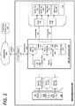
- FIG. 1 is a block diagram illustrating an example self-driving vehicle implementing a neural network control system, as described herein.
- a control system 120 can autonomously operate the SDV 100 in a given geographic region for a variety of purposes, including transport services (e.g., transport of humans, delivery services, etc.).
- the SDV 100 can operate without human control.
- the SDV 100 can autonomously steer, accelerate, shift, brake, and operate lighting components.
- the SDV 100 can switch between an autonomous mode, in which the SDV control system 120 autonomously operates the SDV 100, and a manual mode in which a driver takes over manual control of the acceleration system 152, steering system 154, and braking system 156.
- control system 120 can utilize specific sensor resources in order to intelligently operate the SDV 100 in a variety of driving environments and conditions.
- the control system 120 can operate the vehicle 100 by autonomously operating the steering, acceleration, and braking systems 152, 154, 156 of the SDV 100 to a specified destination.
- the control system 120 can perform vehicle control actions (e.g., braking, steering, accelerating) and route planning using sensor information, as well as other inputs (e.g., transmissions from remote or local human operators, network communication from other vehicles, etc.).
- the control system 120 includes a computer or processing system which operates to process sensor data 111 received from a sensor system 102 of the SDV 100 that provides a sensor view of a road segment upon which the SDV 100 operates.
- the sensor data 111 can be used to determine actions which are to be performed by the SDV 100 in order for the SDV 100 to continue on a route to a destination.
- the control system 120 can include other functionality, such as wireless communication capabilities using a communication interface 115, to send and/or receive wireless communications 117 over one or more networks 160 with one or more remote sources.
- the control system 120 can issue commands 135 to control various electromechanical interfaces of the SDV 100.
- the commands 135 can serve to control the various control mechanisms 155 of the SDV 100, including the vehicle's acceleration system 152, steering system 154, braking system 156, and auxiliary systems 158 (e.g., lights and directional signals).
- the SDV 100 can be equipped with multiple types of sensors 101, 103, 105 which can combine to provide a computerized perception of the space and the physical environment surrounding the SDV 100.
- the control system 120 can operate within the SDV 100 to receive sensor data 111 from the collection of sensors 101, 103, 105 and to control the various control mechanisms 155 in order to autonomously operate the SDV 100.
- the control system 120 can analyze the sensor data 111 to generate low level commands 135 executable by one or more controllers 140 that directly control the acceleration system 152, steering system 154, and braking system 156 of the SDV 100. Execution of the commands 135 by the controllers 140 can result in throttle inputs, braking inputs, and steering inputs that collectively cause the SDV 100 to operate along sequential road segments to a particular destination.
- the sensors 101, 103, 105 operate to collectively obtain a sensor view for the vehicle 100 (e.g., in a forward operational direction, or providing a 360 degree sensor view), and further to obtain situational information proximate to the SDV 100, including any potential hazards or obstacles.
- the sensors 101, 103, 105 can include multiple sets of camera systems (video cameras, stereoscopic cameras or depth perception cameras, long range monocular cameras), remote detection sensors such as radar, LIDAR, and sonar, proximity sensors, infrared sensors, touch sensors, and the like.
- the sensors can be arranged or grouped in a sensor system or array 102 (e.g., in a sensor pod mounted to the roof of the SDV 100) comprising any number of LIDAR, radar, monocular camera, stereoscopic camera, sonar, infrared, or other active or passive sensor systems.
- a sensor system or array 102 e.g., in a sensor pod mounted to the roof of the SDV 100 comprising any number of LIDAR, radar, monocular camera, stereoscopic camera, sonar, infrared, or other active or passive sensor systems.
- Each of the sensors 101, 103, 105 can communicate with the control system 120 utilizing a corresponding sensor interface 110, 112, 114.
- Each of the sensor interfaces 110, 112, 114 can include, for example, hardware and/or other logical components which are coupled or otherwise provided with the respective sensor.
- the sensors 101, 103, 105 can include a video camera and/or stereoscopic camera set which continually generates image data of the physical environment of the SDV 100.
- the sensor interfaces 110, 112, 114 can include dedicated processing resources, such as provided with field programmable gate arrays (FPGAs) which can, for example, receive and/or preprocess raw image data from the camera sensor.
- FPGAs field programmable gate arrays
- the SDV control system 120 can implement a neural network 124 executing a machine learning model (e.g., a set of machine learning algorithms) to autonomously operate the control mechanisms 155 of the SDV 100.
- the control system 120 can receive a destination 119 either from an external entity over the network 160 (e.g., a backend route management system), or via input from a passenger of the SDV 100.
- the control system 120 can include a route planner 122 and a database 130 storing coarse road network maps 131, which the route planner 122 can utilize to determine a route 123 from a current location of the SDV 100 to the destination 119.
- the route planner 122 can also access third party network resources 165 over the one or more networks 160 to receive map data and/or traffic data to determine a most optimal route 123 to the destination 119.
- the route planner 122 can update the route 123 dynamically as traffic conditions change while the SDV 100 is en route to the destination 119.
- the updates to the route 123 can cause the neural network 124 to adapt certain configurations that enable it to follow or track the updated route 123.
- the neural network 124 can receive GPS data 127 from a GPS module 125 of the SDV 100, and establish one or more navigation points 129 on the route 123 affixed a certain distance or temporally ahead of the SDV 100.
- examples are not limited to a single navigation point 129, but can comprise a pair, or any number of navigation points 129 set along the route 123 and in a forward operational direction of the SDV 100.
- the navigation point(s) 129 can be established in global coordinates, whereas the destination 119 can be established in local coordinates.
- the navigation point(s) 129 can be set to be persistently ahead of the SDV 100 (e.g., fifty meters ahead), and can have coordinate values that continuously update in global coordinates as the SDV 100 progresses along the route 123.
- the neural network 124 can establish the destination 119 in local coordinates with respect to the traveling SDV 100.
- the neural network 124 can be trained to follow the navigation point(s) 129, which can act as a reference for the neural network 124 to make upcoming decisions, such as lane selections, acceleration and braking inputs in anticipation of a turn, and the turning actions themselves.
- the neural network 124 is provided with a simple framework that enables the neural network 124 perform mid and high level operations on the control mechanisms 155 analogous to human decision-making to anticipate upcoming turns (e.g., lane selection, deceleration, and braking).
- a local coordinate system may be established with the SDV's location as the origin point (e.g., in a local Cartesian x-y coordinate system). Thereafter, the navigation points 129 may be generated in this local coordinate system to be persistently ahead of the SDV 100 along the route 123.
- the neural network 124 can readily compare the coordinate values of the navigation points 129 in the local coordinate system of the SDV 100 (e.g., to determine an immediate route plan for an upcoming route segment). Additionally or alternatively, the neural network 124 can compare the coordinate values of the navigation points 129 with successive destinations set along the route 123 to identify route features, such as upcoming turns. Based on the comparisons between the coordinate values, the neural network 124 can modulate the acceleration, braking, and steering inputs accordingly.
- the navigation points 129 may be established to be persistently ahead of the SDV 100 along the current route, or may be selectively established ahead of the SDV 100 when the SDV 100 approaches various decision points along the route.
- the navigation points 129 may be excluded when the route ahead of the SDV 100 provides only limited decision-making (e.g., a straight road with no intersections), which enables the neural network 124 to focus mainly on the sensor data 111 to identify an potential hazards and modulate steering, braking, and acceleration inputs based on observation of the SDV's situational surroundings.
- the navigation points 129 can be established, as described herein, to enable the neural network 124 to readily determine the immediate plan for the decision point (e.g., a turn action), and execute acceleration, braking, steering, and/or lane changing actions accordingly.
- the immediate plan for the decision point e.g., a turn action
- the one or more navigation points 129 may be triggered based on a predetermined distance or time prior to the SDV 100 approaching an intersection.
- a road network map may be utilized to identify approach zones for decision areas (e.g., intersections), which can trigger the navigation points 129.
- the navigation points 129 may be triggered based on other parameters, such as a braking input by the neural network 124, a threshold speed being exceeded or crossed below, and the like.
- the neural network 124 can analyze the sensor data 111 to detect other vehicles and any potential obstacles, hazards, or objects of interest (e.g., pedestrians or bicyclists). In variations, the neural network 124 can further analyze the sensor data 111 to detect traffic lanes, bike lanes, road signs, traffic signals, the current speed limit, and road markers (e.g., arrows painted on the road). In processing the sensor data 111, the neural network 124 does not require detailed localization maps or sub-maps of prerecorded and processed road segments along the route 123.
- the neural network 124 can implement machine learning to analyze the sensor data 111 to detect and identify objects of interest, ignore other objects, and operate the control mechanisms 155 of the SDV 100 to avoid any potential incidents.
- a more detailed discussion of the neural network 124 is provided below with respect to FIG. 2 .
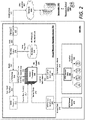
- FIG. 2 is a block diagram illustrating an example neural network navigation system utilized in connection with a self-driving vehicle, according to examples described herein.
- the neural network navigation system 200 of the SDV 201 shown in FIG. 2 can perform one or more functions of the SDV control system 120 and neural network 124 as shown and described with respect to FIG. 1 .
- the neural network navigation system 200 can comprise neural processing resources 250 that implement deep learning to train, adapt, and improve autonomous driving capabilities.
- the neural network navigation system 200 can include a network interface 255 that connects the neural network navigation system 200 to one or more networks 260.
- the network interface 255 can communicate with one or more external devices over the network 260 to receive successive destinations 262.
- the neural network navigation system 200 can communicate with a datacenter 290 hosting a backend transportation management system that deploys a fleet of SDVs throughout a given region (e.g., a metropolitan area) to provide application-based, on-demand transportation services, such as those provided by Uber Technologies, Inc.
- the datacenter 290 can receive driver and SDV locations throughout the given region, receive pick-up requests from requesting users 294, match those users with proximate available drivers or SDVs, and send invitations to those drivers and SDVs to service the pick-up requests.
- the datacenter 290 can transmit a destination 262 to the SDV 201, where the destination 262 corresponds to the pick-up location in which the SDV 201 is to rendezvous with the requesting user 294.
- the requesting user 294 or the datacenter 290 can provide the SDV 201 with a new destination 262-corresponding to a desired drop-off location for the user.
- the neural network navigation system 200 can receive the destination 262 locally from the passenger via an on-board interface, such as a display screen or a voice input interface (e.g., implementing speech recognition). Accordingly, the overall journey of the SDV 201 over the course of any given time frame can comprise a sequence of destinations 262 wherever a road network exists.
- the destination 262 can be submitted to a routing engine 240 of the neural network navigation system 200.
- the routing engine 240 can access a database 230 storing road network maps 231, and can determine an optimal route 242 for the SDV 201 to travel from a current location to the destination 262.
- the optimal route 242 can comprise a route that minimizes distance or time with regards to traffic conditions, speed limits, traffic signals, intersections, and the like.
- the neural network navigation system 200 can include a GPS module 210 (or other location-based resource) that can establish one or more navigation point signals 212 for the SDV 201 at predetermined distances in a forward operational direction of the SDV 201 along the route. As described herein, the navigation points corresponding to the navigation point signals 212 can be established to be persistently ahead of the SDV 201 along the route 242, either distance-wise or temporally.
- the GPS module 210 can provide the neural processing resources 250 with GPS signals corresponding to the navigation points, which the neural processing resources 250 can project ahead of the SDV 200 as navigation points to follow along the route 242 to the destination 262.
- the neural network processing resources 250 can establish the navigation point signals 212 in global coordinates, or coordinates with respect to an inertial frame of reference. Accordingly, as the SDV 201 travels throughout the given region, the coordinate values of the navigation points will vary with respect to the inertial reference frame. As such, the navigation points can be affixed to the SDV's 201 non-inertial reference frame at predetermined distances ahead of the SDV 201 along the route 242 (e.g., analogous to an L4 Lagrange point).
- the neural network navigation system 200 can establish the destination coordinates 214 in local coordinates, or as an address point, in the non-inertial reference frame of the SDV 100. Accordingly, the navigation point coordinates can be tracked by the neural processing resources 250 to the destination 262 by comparison of their coordinate values and/or the coordinate values of the vehicle 211.
- the navigation points 212 can be established in a local coordinate system having an origin at the SDV's current location. Furthermore, the neural network processing resources 250 can readily compare the coordinate values of the navigation points 212 with the SDV's current location as the origin. Additionally or alternatively, the navigation points 212 can be computed based on the current location of the SDV 201 and the map route 242 of the SDV 201 from the current location to an overall destination.
- the coordinates for the navigation points 212 can comprise two-dimensional coordinates that the neural processing resources 250 can continuously analyze in order to anticipate and execute turns, make lane selections, speed up or slow down, and otherwise vary the acceleration, braking, and steering inputs for the SDV 201.
- each navigation point 212 comprises a Cartesian x-coordinate and y-coordinate, which provides a simple framework for the neural processing resources 250 to track and make control decisions in autonomously operating the SDV 201, as described in further detail below.
- the neural processing resources 250 executes a machine learning model 236 to utilize both the navigation point signals 212 and sensor data 272 from a number of sensor systems 270 of the SDV 201.
- the SDV sensor systems 270 can comprise monocular and/or stereoscopic cameras. Additionally or alternatively, the SDV sensor systems 270 can include one or more LIDAR systems, radar systems, sonar systems, and/or proximity sensors that can generate the sensor data 272 to be analyzed by the neural processing resources 250 of the neural network navigation system 200.
- the sensor data 272 can be received via a SDV sensor interface 255, and can be submitted in raw form to the neural processing resources 250, or may be preprocessed by addition processing resources of the SDV 201 to eliminate non-essential data in order to reduce overall load on the neural processing resources 250.
- the neural processing resources 250 may end up relying heavily on tracking the signals 212 without sufficient reliance on the sensor data 272.
- the neural network navigation system 200 includes noise generator 215 to introduce or otherwise incorporate noise (e.g., Gaussian distributed noise) into the navigation point signals 212 to generate coarse navigation points 217 for the neural processing resources 250 to track along the route 242.
- the introduced noise can result in larger horizontal error in the navigation point signals 212, and can cause the neural network processing resources 250 to desirably rely on the sensor data 272 in order to increase robustness of the system 200.
- the navigation point signals 212 are run through a noise generator 215 to add noise, resulting in coarse navigation points 217.
- These coarse navigation points 217 can be received as inputs by the neural processing resources 250-along with the sensor data 272 and destination coordinates 214-to generate control instructions 242 to autonomously operate the control mechanisms of the SDV 200.
- the neural processing resources 250 can extract the coarse navigation points 217 in global coordinates to localize along the optimal route 242 and continuously compute a future destination for the SDV 200.
- the neural processing resources 250 can extract multiple coarse navigation points 217 at predetermined distances or temporally ahead of the SDV 201 along the optimal route 242 (e.g., based on the SDV's orientation and/or localization parameters), and continuously monitor the coordinate values of each of the coarse navigation points 217.
- the neural processing resources 250 compare the coordinate values of the coarse navigation points 217 to vehicle coordinates 211 of the SDV 201 to make mid or high level decisions with regard to an immediate route plan for an upcoming route segment.
- the neural processing resources 250 can correlate the coordinate values of the coarse navigation points 217, which can indicate, among other things, an upcoming turn.
- converging x-values between the navigation points 217 can indicate an upcoming or imminent turn, whereas the positive or negative aspect of the y-value can indicate the direction of the turn, as illustrated further in FIG. 3 .
- diverging angular values can indicate an upcoming turn and a turn direction.
- the neural processing resources 250 can utilize the coordinate values of the coarse navigation points 217 to adjust inputs for accelerating, braking, and steering the SDV 201.
- the neural processing resources 250 can further receive, as additional input, the destination coordinates 214 as local coordinates in relation to the SDV 201.
- each road segment for each immediate route plan can comprise one or more upcoming or immediate destinations in local coordinates of the SDV's local coordinate system (i.e., with the SDV's dynamic position as the origin).
- Each of these destinations can comprise fixed destination coordinates 214 in the SDV's local coordinate system.
- the neural processing resources 250 can utilize the destination coordinates 214 as successive targeted endpoints for each immediate route segment, or as an overall endpoint for the current trip.
- the neural processing resources 250 can compare the navigation point coordinate values with the SDV's current coordinates and orientation (and additional vehicle parameters, such as speed, acceleration and braking inputs, etc.), and the successive destination coordinates 214.
- the neural processing resources 250 can be trained to balance processing between tracking the coarse navigation points 217 along the route 242 and analyzing the sensor data 272 for potential hazards.
- the neural processing resources 250 can generate control instructions 242 executable by an SDV control unit 280 to operate the steering system 282, braking system 284, acceleration system 286, and the signaling and auxiliary systems 288 of the SDV 201.
- the neural network navigation system 200 can include a SDV control interface 245 through which the control instructions 242 are transmitted to the SDV control unit 280 for execution.
- the SDV control unit 280 can process the control instructions 242 to generate control commands 289 for direct implementation on the steering 282, braking 284, acceleration 286, and/or signaling systems 288 of the SDV 201.
- the logical processes shown in connection with FIG. 2 are discussed in the context of logical blocks representing various elements and logic flows of the neural network navigation system 200. However, one or more of the foregoing processes may be performed by the backend datacenter 290, such as establishing the navigation points 217 based on the current location 297 of the SDV 201 and the optimal route 242, introducing noise to the navigation point signals 212, and determining the optimal route 242 for the SDV 201 to the destination 262.
- the backend datacenter 290 such as establishing the navigation points 217 based on the current location 297 of the SDV 201 and the optimal route 242, introducing noise to the navigation point signals 212, and determining the optimal route 242 for the SDV 201 to the destination 262.
- the coarse navigation points 217 may be established by the datacenter 290 in global coordinates fixed to the SDV's 200 frame of reference, enabling the neural processing resources 250 to utilize basic road network maps 231 to extract and track the coarse navigation points 217 in order to autonomously operate the SDV 200 along the route 242.
- the neural processing resources 250 may not only follow the route and perform lane-keeping, but may also make decisions concerning upcoming turns, such as lane selection, signaling, safety checks (e.g., analyzing the sensor data 272 for safe lane-changing and turning opportunities), and anticipatory braking and acceleration.
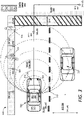
- FIG. 3 shows an example of an autonomously controlled self-driving vehicle utilizing sensor data to navigate an environment in accordance with example implementations.
- the autonomous vehicle 310 may include various sensors, such as a roof-top camera array (RTC) 322, forward-facing cameras 324 and laser rangefinders 330.
- RTC roof-top camera array
- a data processing system 325 comprising a combination of one or more processors, FPGAs, and/or memory units, can be positioned in the cargo space of the vehicle 310.
- the vehicle 310 uses one or more sensor views 303 (e.g., a stereoscopic or 3D image of the environment 300) to scan a road segment on which the vehicle 310 traverses.
- the vehicle 310 can process image data or sensor data, corresponding to the sensor views 303 from one or more sensors in order to detect objects that are, or may potentially be, in the path of the vehicle 310.
- the detected objects include a bicyclist 302, a pedestrian 304, and another vehicle 327-each of which may potentially cross into a road segment 315 along which the vehicle 310 traverses.
- the vehicle 310 can use information about the road segment and/or image data from the sensor views 303 to determine that the road segment includes a divider 317 and an opposite lane, as well as a sidewalk (SW) 321 and sidewalk structures such as parking meters (PM) 327.
- SW sidewalk
- PM parking meters
- the vehicle 310 may determine the location, size, and/or distance of objects in the environment 300 based on the sensor view 303.
- the sensor views 303 may be 3D sensor images that combine sensor data from the roof-top camera array 322, front-facing cameras 324, and/or laser rangefinders 330. Accordingly, the vehicle may accurately detect the presence of objects in the environment 300, allowing the vehicle to safely navigate the route while avoiding collisions with other objects.
- the vehicle 310 may determine a probability that one or more objects in the environment 300 will interfere or collide with the vehicle 310 along the vehicle's current path or route.
- the vehicle 310 may selectively perform an avoidance action based on the probability of collision.
- the avoidance actions may include velocity adjustments, lane aversion, roadway aversion (e.g., change lanes or drive further from the curb), light or horn actions, and other actions.
- the avoidance action may run counter to certain driving conventions and/or rules (e.g., allowing the vehicle 310 to drive across center line to create space with bicyclist).
- the vehicle 310 may implement a deep neural network through a series of training, test, and real-world implementation phases to ultimately build a robust skillset in autonomously operating the vehicle 310 on par with or exceeding human ratings or safety standards for autonomous driving.
- the deep neural network can make on-the-fly assessments with regard to each detected object, and proactively control the autonomous vehicle 310 in accordance with certain safety standards (e.g., Safe Practices for Motor Vehicle Operations standards).
- the deep neural network can seek to optimize autonomous driving habits in light of minimizing risk of collision (e.g., by identifying and anticipating potentially dangerous situations), implementing an assured clear distance ahead (e.g., a velocity-based following standard), and even practicing specific driving techniques geared towards efficiency and safety.
- the data processing system 325 can implement the deep neural network (e.g., via execution of a set of machine learning algorithms) to identify static objects such as parking meters 327, and can accurately determine that the parking meters 327 are fixed objects (e.g., based on their relatively static or stable locations in the sensor views 303).
- the deep neural network can further detect and positively identify potential hazards, such as the bicyclist 302, pedestrian 304, and other vehicle 327.
- the deep neural network can further identify other objects in the sensor view 303 that may affect the manner in which the autonomous vehicle 310 travels along its given route 366, such as a crosswalk 315 and traffic signal 340.
- the deep neural network can identify the lane divider markers 317 and other road features indicating the bounds of the current lane being traveled (e.g., painted lines, curbs, parked cars, bike lanes, transition zones from concrete or asphalt to dirt or grass, and the like).
- the deep neural network can extract one or more navigation points (e.g., navigation point 360 and navigation point 362) along the current route 366 of the vehicle 310.
- the navigation points 360, 362 can comprise two-dimensional Cartesian coordinate points established in global coordinates, and can be affixed as "carrot" points to the non-inertial reference frame of the vehicle 310.
- the coordinate values of each navigation point 360, 362 can vary with respect to the global coordinate system 380 as the vehicle 310 travels along the current route 366.
- the deep neural network can track the navigation points 360, 362 along the route 366, dynamically compare the coordinate values of the navigation points 360, 362 with respect to each other (and/or the vehicle coordinates 323 of the SDV 310), and utilize the compared values to make decisions regarding the upcoming road segment of the SDV 310, such as lane selections and anticipatory actions (e.g., braking, signaling, checking individual portions of the sensor view, etc.).
- lane selections e.g., braking, signaling, checking individual portions of the sensor view, etc.
- the global coordinate system 380 can comprise a mapping grid for a given area (e.g., based on an east/west and north/south grid, corresponding to the x and y axes respectively) that enables the deep neural network to determine upcoming characteristics of the route 366-such as road curves and turns-by following the navigation points 360, 362.
- the deep neural network can utilize the vehicle's own coordinates 323 to compare with one or more navigation points 360, 362 set in the forward direction of the vehicle. As such, converging x-values can correspond to an upcoming turn, and diverging y-values can correspond to the direction of the upcoming turn.
- the x-convergence and y-divergence can enable the deep neural network to respond to by selecting an appropriate lane, signaling using the vehicle's directional signals, braking at the upcoming intersection or turn, and steering and accelerating to complete the turn.
- the use of two-dimensional Cartesian coordinates is provided herein for illustration only, and is not meant to be limiting in any way.
- the navigation points 360, 362, the vehicle coordinates 323, and the destination coordinates may be in any two-dimensional or three-dimensional coordinate system or reference frame, and can utilize any combination of Cartesian global and local coordinates, two-dimensional polar global coordinates and local coordinates, and/or three-dimensional spherical global and/or local coordinates.
- the deep neural network implemented on the data processing system 325 can extract the coordinate values of the navigation points 360, 362 (in any set coordinate system)-as the vehicle 310 travels throughout a given region-for dynamic comparison in order to determine an immediate route plan (e.g., for the next hundred meters or the next thirty seconds of driving) and execute any number control actions on the vehicle 310 to implement the immediate route plan.
- an immediate route plan e.g., for the next hundred meters or the next thirty seconds of driving
- the deep neural network can dynamically analyze the sensor view 303 for lower level safety concerns, such as potential hazard threats from other vehicles 327, local pedestrians 304 and bicyclists 302.
- the deep neural network may further process the sensor view 303 to identify road and traffic features-such as the traffic signal 340 and signal state (e.g., red, yellow, or green), crosswalk 315, sidewalk 321, and lane divider 317-in order to make lower level decisions with regards to actual execution of lane changes, braking for an upcoming intersection, and safely executing upcoming turns identified by the navigation points 360, 362.
- road and traffic features such as the traffic signal 340 and signal state (e.g., red, yellow, or green)
- crosswalk 315 e.g., sidewalk 321, and lane divider 317-in order to make lower level decisions with regards to actual execution of lane changes, braking for an upcoming intersection, and safely executing upcoming turns identified by the navigation points 360, 362.
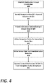
- FIG. 4 is a flow chart describing an example method of autonomously operating a self-driving vehicle through use of a neural network, according to examples described herein.
- a neural network 124 or neural network navigation system 200 being implemented on a self-driving vehicle 100, 200, as shown and described herein.
- the neural network 124 can establish a destination 119 in local coordinates (400).
- the neural network 124 can further identify one or more navigation points 129 in a forward operational direction of the SDV 100 (405).
- the navigation points 129 may be extracted and established at affixed distances (or temporally) ahead of the SDV 100 by a backend entity with knowledge of the destination 119 and optimal route 123.
- the navigation points 129 may be extracted and established by a separate module of the of the SDV 100, or the neural network 124 itself, once the optimal route 123 to the destination 119 is determined.
- the neural network 124 may also process sensor data 111 indicating a sensor view from a sensor array 102 of the SDV 100 (410). According to some aspects described herein, the neural network 124 can utilize the navigation points 129 dynamically for an immediate route plan (415). Accordingly, the neural network 124 can compare the individual coordinate values of the navigation points 129 with each other-and/or with the vehicle coordinates of the SDV 100-in order to determine the immediate route plan for the upcoming road segment.
- the immediate route plan can comprise a plan for the next fifty or one hundred meters- or a set time period (e.g., the next thirty seconds)-of the overall route 123 of the SDV 100, and can correlate directly with the location of the navigation points 129 ahead of the SDV 100.
- the immediate route plan can correspond to an upcoming turn in which the SDV 100 must signal, change lanes, and execute the turn.
- the neural network 124 may utilize the sensor data 111 for immediate action execution (420).
- the immediate action execution can comprise generating the individual command inputs 135 executable by the individual control mechanisms 155 of the SDV 100, such as the SDV's acceleration 152, steering 154, braking 156, and auxiliary systems 158.
- the neural network 124 can analyze the sensor data 111 to determine exactly when to change lanes, brake for an intersection or potential hazard, and accelerate and steer the SDV 100 when the situation is safe to complete the turn.
- the neural network 124 can autonomously operate the control mechanisms 155 of the SDV 100 to track the navigation points 129 along the given route 123 (425).
- FIG. 5 is a lower level flow chart describing an example method of autonomously operating a self-driving vehicle through use of a neural network, according to examples described herein.
- a neural network 124 or neural network navigation system 200 being implemented on a self-driving vehicle 100, 200, as shown and described herein.
- the neural network navigation system 200 can receive a destination 262 (500).
- the destination 262 can be received from a backend transportation management system implemented on a datacenter 290 (504), or can be inputted directly by a passenger of the SDV 201 through use of a local user interface (502).
- the neural network navigation system 200 can determine a route 242 from a current location to the destination 262 (505), and set the destination 262 in local coordinates relative to the SDV 201 (510).
- the neural network navigation system 200 can further set one or more navigation points 212 in global coordinates, and affix or otherwise configure the navigation point(s) 212 to the non-inertial reference frame of the SDV 201 (515).
- the neural network navigation system 200 can set the navigation points at persistent distances ahead of the SDV 201 along the route 242 (516), or temporally such that the navigation points 212 vary in distance from the SDV 201 (e.g., based on the SDV's current speed (517).
- the temporal location for each of the navigation points 212 may be based on a computation of a time step (e.g., one or two seconds ahead of the SDV 201) and the SDV's current speed.
- the global coordinate values of the SDV 201 e.g., via the GPS module 210) can be utilized to establish a local coordinate system with the SDV's current, dynamic location as the origin.
- the navigation points 212, and successive upcoming destination coordinates 214 can be established in the SDV's local coordinate system along the route 242.
- a local Cartesian coordinate system (e.g., a two-dimensional x-y system) can be established with the positive x-axis extending in the forward operational direction of the SDV 201, and positive y-axis extending to the left of the SDV 201.
- the navigation point coordinates 212 and/or the successive destination coordinates 214 can be established with respect to this local Cartesian system, enabling the neural network processing resources 250 to readily identify, for example, an upcoming turn.
- the neural network navigation system 200 can set a combination of distance-based and temporally-based navigation points 212 to further increase robustness.
- the neural network navigation system 200 can set the number of navigation points (518), and can include a single point, or multiple points at various distances and/or times ahead of the SDV 201 along the route.
- the neural network navigation system 200 includes or otherwise introduces noise into the navigation point signals 212, such that the navigation points 212 comprise coarse navigation points 217 with a certain amount of increased horizontal error (520). As described herein, this can prevent the neural processing resources 250 of the neural network navigation system 200 to over-rely on the navigation points 217 in at least the training phase of the system 200, resulting in increased robustness of the system 200.
- the noise can be included in only the training and/or testing phases of the system 200. In such aspects, the noise can be excluded or reduced in the implementation phase. In variations, the noise may also be included during implementation of the system 200 on public roads.
- the neural network navigation system 250 receives sensor data 272 from the SDV sensor systems (525), which can include LIDAR data (526), camera or image data (527), and/or radar data (528). It is contemplated that the neural network navigation system 250 can be agnostic to the type of sensor data sources, and can utilize data from any individual sensor system (e.g., a single monocular, forward-facing camera), or combinations of sensor systems described herein.
- SDV sensor systems can include LIDAR data (526), camera or image data (527), and/or radar data (528). It is contemplated that the neural network navigation system 250 can be agnostic to the type of sensor data sources, and can utilize data from any individual sensor system (e.g., a single monocular, forward-facing camera), or combinations of sensor systems described herein.
- the neural network navigation system 200 can dynamically analyze and compare coordinate values to continuously or periodically (e.g., every few seconds) determine an immediate route plan (530). As discussed above, the neural network navigation system 200 can compare various combinations of individual coordinate values of the coarse navigation points 217 (531), the vehicle coordinates of the SDV 201 (532), and the destination coordinates 214 (533). In certain implementations, the neural processing resources can determine a heading of the SDV 201, and utilize the heading to make comparisons between the coordinate values to ultimately determine the immediate route plan. Based on each of the immediate route plans, the neural network navigation system 200 can operate the SDV control mechanisms in order to track the coarse navigation points 217 to the destination 262 (535).
- the neural network navigation system 200 can operate the acceleration system 286 (536), the braking system 284 (537), and the steering system 282 (538) of the SDV 201 in order to perform the low level autonomous actions that progress the SDV 201 along each immediate route plan along the overall route 242 to the destination 262.
- FIG. 6 is a block diagram illustrating a computer system upon which example SDV processing systems described herein may be implemented.
- the computer system 600 can be implemented using a number of processing resources 610, which can comprise processors 611, field programmable gate arrays (FPGAs) 613.
- processors 611 and/or FPGAs 613 of the computer system 600 can be utilized as components of a neural network array 617 implementing a machine learning model 662 and utilizing road network maps 664 stored in memory 661 of the computer system 600.
- the control system 120, neural network 124, and neural network navigation system 200 can be implemented using one or more components of the computer system 600 shown in FIG. 6 .
- the computer system 600 may be implemented within an autonomous vehicle or self-driving vehicle (SDV) with software and hardware resources such as described with examples of FIGS. 1 and 2 .
- the computer system 600 can be distributed spatially into various regions of the SDV, with various aspects integrated with other components of the SDV itself.
- the processing resources 610 and/or memory resources 660 can be provided in a cargo space of the SDV.
- the various processing resources 610 of the computer system 600 can also execute control instructions and the machine learning model 662 (e.g., comprising a set of machine learning algorithms) using microprocessors 611, FPGAs 613, or any combination of the same.
- the machine learning model 662 can be executed by various combinations of processors 611 and/or FPGAs 613 that make up the neural network array 617.
- various executable tasks embedded in the machine learning model 662 may be distributed amongst the multiple types of processing resources 610 of the computer system 600 that make up the neural network array 617.
- the computer system 600 can include a communication interface 650 that can enable communications over a network 680.
- the communication interface 650 can also provide a data bus or other local links to electro-mechanical interfaces of the vehicle, such as wireless or wired links to and from control mechanisms 620 (e.g., via a control interface 622), sensor systems 630, and can further provide a network link to a backend transport management system (implemented on one or more datacenters) over one or more networks 680.
- the processing resources 610 can receive a destination 682 over the one or more networks 680, or via a local user interface of the SDV.
- the memory resources 660 can include, for example, main memory 661, a read-only memory (ROM) 667, storage device, and cache resources.
- the main memory 661 of memory resources 660 can include random access memory (RAM) 668 or other dynamic storage device, for storing information and instructions which are executable by the processing resources 610 of the computer system 600.
- the processing resources 610 can execute instructions for processing information stored with the main memory 661 of the memory resources 660.
- the main memory 661 can also store temporary variables or other intermediate information which can be used during execution of instructions by the processing resources 610.
- the memory resources 660 can also include ROM 667 or other static storage device for storing static information and instructions for the processing resources 610.
- the memory resources 660 can also include other forms of memory devices and components, such as a magnetic disk or optical disk, for purpose of storing information and instructions for use by the processing resources 610.
- the computer system 600 can further be implemented using any combination of volatile and/or nonvolatile memory, such as flash memory, PROM, EPROM, EEPROM (e.g., storing firmware 669), DRAM, cache resources, hard disk drives, and/or solid state drives.
- the memory 661 may store a set of software instructions and/or machine learning algorithms including, for example, the machine learning model 662.
- the memory 661 may also store road network maps 664 in which the processing resources 610-executing the machine learning model 662-can utilize to extract and follow navigation points (e.g., via location-based signals from a GPS module 640), introduce noise to the navigation point signals, determine successive route plans, and execute control actions on the SDV.
- the machine learning model 662 may be executed by the neural network array 617 in order to autonomously operate the SDV's acceleration 622, braking 624, steering 626, and signaling systems 628 (collectively, the control mechanisms 620).
- the neural network array 617 can make mid or high level decisions with regard to upcoming route segments, and the processing resources 610 can receive sensor data 632 from the sensor systems 630 to enable the neural network array 617 to dynamically generate low level control commands 615 for operative control over the acceleration, steering, and braking of the SDV.
- the neural network array 317 may then transmit the control commands 615 to one or more control interfaces 622 of the control mechanisms 620 to autonomously operate the SDV through road traffic on roads and highways, as described throughout the present disclosure.
Landscapes
- Engineering & Computer Science (AREA)
- Physics & Mathematics (AREA)
- Remote Sensing (AREA)
- Radar, Positioning & Navigation (AREA)
- General Physics & Mathematics (AREA)
- Theoretical Computer Science (AREA)
- Automation & Control Theory (AREA)
- Health & Medical Sciences (AREA)
- Artificial Intelligence (AREA)
- Evolutionary Computation (AREA)
- Software Systems (AREA)
- Computing Systems (AREA)
- General Engineering & Computer Science (AREA)
- General Health & Medical Sciences (AREA)
- Mathematical Physics (AREA)
- Data Mining & Analysis (AREA)
- Computational Linguistics (AREA)
- Biophysics (AREA)
- Biomedical Technology (AREA)
- Life Sciences & Earth Sciences (AREA)
- Molecular Biology (AREA)
- Aviation & Aerospace Engineering (AREA)
- Human Computer Interaction (AREA)
- Mechanical Engineering (AREA)
- Transportation (AREA)
- Traffic Control Systems (AREA)
- Navigation (AREA)
- Control Of Driving Devices And Active Controlling Of Vehicle (AREA)
- Management, Administration, Business Operations System, And Electronic Commerce (AREA)
- Business, Economics & Management (AREA)
- Game Theory and Decision Science (AREA)
- Medical Informatics (AREA)
Applications Claiming Priority (2)
| Application Number | Priority Date | Filing Date | Title |
|---|---|---|---|
| US15/295,088 US10452068B2 (en) | 2016-10-17 | 2016-10-17 | Neural network system for autonomous vehicle control |
| PCT/US2017/056277 WO2018075325A1 (en) | 2016-10-17 | 2017-10-12 | Neural network system for autonomous vehicle control |
Publications (3)
| Publication Number | Publication Date |
|---|---|
| EP3526737A1 EP3526737A1 (en) | 2019-08-21 |
| EP3526737A4 EP3526737A4 (en) | 2020-03-25 |
| EP3526737B1 true EP3526737B1 (en) | 2022-08-03 |
Family
ID=61902218
Family Applications (1)
| Application Number | Title | Priority Date | Filing Date |
|---|---|---|---|
| EP17862728.7A Active EP3526737B1 (en) | 2016-10-17 | 2017-10-12 | Neural network system for autonomous vehicle control |
Country Status (6)
| Country | Link |
|---|---|
| US (1) | US10452068B2 (zh) |
| EP (1) | EP3526737B1 (zh) |
| JP (1) | JP6651678B2 (zh) |
| CN (1) | CN109863513B (zh) |
| CA (1) | CA3038542C (zh) |
| WO (1) | WO2018075325A1 (zh) |
Families Citing this family (74)
| Publication number | Priority date | Publication date | Assignee | Title |
|---|---|---|---|---|
| US10733506B1 (en) | 2016-12-14 | 2020-08-04 | Waymo Llc | Object detection neural network |
| EP3805889A1 (en) * | 2016-12-23 | 2021-04-14 | Mobileye Vision Technologies Ltd. | Navigational system monitoring host and target vehicle behaviour |
| JP6828429B2 (ja) * | 2016-12-27 | 2021-02-10 | 株式会社デンソー | 車両用衝突回避支援装置および車両の衝突回避支援方法 |
| US10759415B2 (en) * | 2017-02-23 | 2020-09-01 | GM Global Technology Operations LLC | Effective rolling radius |
| KR101878490B1 (ko) * | 2017-03-10 | 2018-07-13 | 만도헬라일렉트로닉스(주) | 차선 인식 시스템 및 방법 |
| CN115855022A (zh) * | 2017-04-07 | 2023-03-28 | 辉达公司 | 使用深度神经网络执行自主路径导航 |
| US11190944B2 (en) | 2017-05-05 | 2021-11-30 | Ball Aerospace & Technologies Corp. | Spectral sensing and allocation using deep machine learning |
| US10271179B1 (en) * | 2017-05-05 | 2019-04-23 | Ball Aerospace & Technologies Corp. | Geolocation determination using deep machine learning |
| US11358608B2 (en) * | 2017-05-06 | 2022-06-14 | The Texas A&M University System | Method and system for vehicular communication and safety monitoring of driving environment to provide early warnings in real-time |
| KR102628790B1 (ko) * | 2017-06-20 | 2024-01-24 | 모셔널 에이디 엘엘씨 | 자율 주행 능력들을 갖는 차량들에 대한 위험 처리 |
| US10621448B2 (en) * | 2017-08-02 | 2020-04-14 | Wing Aviation Llc | Systems and methods for determining path confidence for unmanned vehicles |
| US11210744B2 (en) | 2017-08-16 | 2021-12-28 | Mobileye Vision Technologies Ltd. | Navigation based on liability constraints |
| US10496098B2 (en) * | 2017-09-12 | 2019-12-03 | Baidu Usa Llc | Road segment-based routing guidance system for autonomous driving vehicles |
| US11093829B2 (en) * | 2017-10-12 | 2021-08-17 | Honda Motor Co., Ltd. | Interaction-aware decision making |
| US11657266B2 (en) | 2018-11-16 | 2023-05-23 | Honda Motor Co., Ltd. | Cooperative multi-goal, multi-agent, multi-stage reinforcement learning |
| CA3028278A1 (en) * | 2017-11-23 | 2019-05-23 | Beijing Didi Infinity Technology And Development Co., Ltd. | System and method for estimating arrival time |
| EP3499406B1 (en) * | 2017-12-18 | 2024-01-31 | Aptiv Technologies Limited | Methods of processing and generating image data in a connectionist network |
| US10990096B2 (en) * | 2018-04-27 | 2021-04-27 | Honda Motor Co., Ltd. | Reinforcement learning on autonomous vehicles |
| CN108897313A (zh) * | 2018-05-23 | 2018-11-27 | 清华大学 | 一种分层式端到端车辆自动驾驶系统构建方法 |
| US11334960B2 (en) * | 2018-06-08 | 2022-05-17 | Uatc, Llc | Systems and methods for pipelined processing of sensor data using hardware |
| US11427211B2 (en) * | 2018-06-18 | 2022-08-30 | Baidu Usa Llc | Methods for handling sensor failures in autonomous driving vehicles |
| US10457294B1 (en) * | 2018-06-27 | 2019-10-29 | Baidu Usa Llc | Neural network based safety monitoring system for autonomous vehicles |
| US11454975B2 (en) | 2018-06-28 | 2022-09-27 | Uatc, Llc | Providing actionable uncertainties in autonomous vehicles |
| EP3588226B1 (en) * | 2018-06-29 | 2020-06-24 | Zenuity AB | Method and arrangement for generating control commands for an autonomous road vehicle |
| CN112601685A (zh) | 2018-07-06 | 2021-04-02 | 伊戈尔航空有限公司 | 自适应制动和方向控制系统(abadcs) |
| WO2020010489A1 (en) * | 2018-07-09 | 2020-01-16 | Baidu.Com Times Technology (Beijing) Co., Ltd. | A speed control command auto-calibration system for autonomous vehicles |
| WO2020014683A1 (en) * | 2018-07-13 | 2020-01-16 | Kache.AI | Systems and methods for autonomous object detection and vehicle following |
| US20200055524A1 (en) * | 2018-08-20 | 2020-02-20 | Alberto LACAZE | System and method for verifying that a self-driving vehicle follows traffic ordinances |
| FR3086491B1 (fr) * | 2018-09-26 | 2020-09-25 | Psa Automobiles Sa | Assistance a la conduite d’un vehicule, par determination de l’angle de braquage au moyen d’un reseau neuronal sans biais de calcul |
| US11040714B2 (en) * | 2018-09-28 | 2021-06-22 | Intel Corporation | Vehicle controller and method for controlling a vehicle |
| US11182672B1 (en) | 2018-10-09 | 2021-11-23 | Ball Aerospace & Technologies Corp. | Optimized focal-plane electronics using vector-enhanced deep learning |
| US11068724B2 (en) * | 2018-10-11 | 2021-07-20 | Baidu Usa Llc | Deep learning continuous lane lines detection system for autonomous vehicles |
| CN111090277B (zh) * | 2018-10-22 | 2021-11-26 | 科沃斯机器人股份有限公司 | 行进控制的方法、设备及存储介质 |
| US10879946B1 (en) | 2018-10-30 | 2020-12-29 | Ball Aerospace & Technologies Corp. | Weak signal processing systems and methods |
| US11513515B2 (en) * | 2018-11-27 | 2022-11-29 | SparkCognition, Inc. | Unmanned vehicles and associated hub devices |
| WO2020117530A1 (en) | 2018-12-03 | 2020-06-11 | Ball Aerospace & Technologies Corp. | Star tracker for multiple-mode detection and tracking of dim targets |
| US11520331B2 (en) * | 2018-12-28 | 2022-12-06 | Intel Corporation | Methods and apparatus to update autonomous vehicle perspectives |
| US11353870B2 (en) * | 2018-12-31 | 2022-06-07 | Baidu Usa Llc | Autonomous driving computing and storage expansion device with flexible host and client configuration |
| US11851217B1 (en) | 2019-01-23 | 2023-12-26 | Ball Aerospace & Technologies Corp. | Star tracker using vector-based deep learning for enhanced performance |
| US10919543B2 (en) * | 2019-01-30 | 2021-02-16 | StradVision, Inc. | Learning method and learning device for determining whether to switch mode of vehicle from manual driving mode to autonomous driving mode by performing trajectory-based behavior analysis on recent driving route |
| US11520345B2 (en) * | 2019-02-05 | 2022-12-06 | Nvidia Corporation | Path perception diversity and redundancy in autonomous machine applications |
| US11412124B1 (en) | 2019-03-01 | 2022-08-09 | Ball Aerospace & Technologies Corp. | Microsequencer for reconfigurable focal plane control |
| JP7434714B2 (ja) * | 2019-03-08 | 2024-02-21 | マツダ株式会社 | 車両用演算システム |
| JP7434715B2 (ja) * | 2019-03-08 | 2024-02-21 | マツダ株式会社 | 車両用演算システム |
| EP3907115A4 (en) * | 2019-03-08 | 2022-03-16 | Mazda Motor Corporation | ARITHMETIC OPERATING SYSTEM FOR VEHICLE |
| JP2020142760A (ja) * | 2019-03-08 | 2020-09-10 | マツダ株式会社 | 車両用演算システム |
| US11216001B2 (en) | 2019-03-20 | 2022-01-04 | Honda Motor Co., Ltd. | System and method for outputting vehicle dynamic controls using deep neural networks |
| CN111830949B (zh) * | 2019-03-27 | 2024-01-16 | 广州汽车集团股份有限公司 | 自动驾驶车辆控制方法、装置、计算机设备和存储介质 |
| US11618502B2 (en) * | 2019-03-28 | 2023-04-04 | Volkswagen Aktiengesellschaft | On-road localization methodologies and equipment utilizing road surface characteristics |
| KR20200131664A (ko) | 2019-05-14 | 2020-11-24 | 삼성전자주식회사 | 차량의 주행을 보조하는 전자 장치 및 방법 |
| CN112034829B (zh) * | 2019-05-15 | 2024-07-19 | 广州汽车集团股份有限公司 | 一种端到端自动驾驶方法及其系统、车辆 |
| US11303348B1 (en) | 2019-05-29 | 2022-04-12 | Ball Aerospace & Technologies Corp. | Systems and methods for enhancing communication network performance using vector based deep learning |
| US11488024B1 (en) | 2019-05-29 | 2022-11-01 | Ball Aerospace & Technologies Corp. | Methods and systems for implementing deep reinforcement module networks for autonomous systems control |
| US11120566B2 (en) * | 2019-06-28 | 2021-09-14 | Baidu Usa Llc | Determining vanishing points based on feature maps |
| DE102019211457A1 (de) * | 2019-07-31 | 2021-02-04 | Volkswagen Aktiengesellschaft | Verfahren und System zum Bereitstellen einer kontextabhängigen Wissensbasis zum Plausibilisieren mindestens einer Wahrnehmungsfunktion |
| NL2023628B9 (nl) * | 2019-08-09 | 2021-08-20 | Wilhelmus Maria Van Bentum Johannes | Systeem voor het aansturen van een op basis van stuur- en versnellingswaarden bestuurbaar autonoom rijdend voer- of (lucht)vaartuig, autonoom rijdend voer- of (lucht)vaartuig voorzien van een dergelijk systeem. |
| US11634162B2 (en) | 2019-08-16 | 2023-04-25 | Uatc, Llc. | Full uncertainty for motion planning in autonomous vehicles |
| US11828598B1 (en) | 2019-08-28 | 2023-11-28 | Ball Aerospace & Technologies Corp. | Systems and methods for the efficient detection and tracking of objects from a moving platform |
| US10609148B1 (en) * | 2019-09-17 | 2020-03-31 | Ha Q Tran | Smart vehicle |
| US11520037B2 (en) * | 2019-09-30 | 2022-12-06 | Zoox, Inc. | Perception system |
| CN110940310B (zh) * | 2019-11-15 | 2021-12-07 | 北京遥测技术研究所 | 弹箭载中继测控终端相控阵天线波束指向角度计算方法 |
| CN110956851B (zh) * | 2019-12-02 | 2020-11-24 | 清华大学 | 一种智能网联汽车协同调度换道方法 |
| JP7396125B2 (ja) | 2020-03-03 | 2023-12-12 | オムロン株式会社 | モデル生成装置、推定装置、モデル生成方法、及びモデル生成プログラム |
| JP7464425B2 (ja) * | 2020-03-31 | 2024-04-09 | 本田技研工業株式会社 | 車両制御装置、車両制御方法、及びプログラム |
| US11697433B2 (en) * | 2020-03-31 | 2023-07-11 | Uatc, Llc | Autonomous vehicle computing system compute architecture for assured processing |
| US12041396B2 (en) * | 2020-07-16 | 2024-07-16 | R9 Labs, Llc | Systems and methods for processing data proximate to the point of collection |
| CN111708369B (zh) * | 2020-07-17 | 2021-07-23 | 武汉科技大学 | 一种变电站巡检机器人路径规划方法 |
| CN112254755B (zh) * | 2020-11-11 | 2022-01-04 | 北京邮电大学 | 测量信号处理方法、装置、电子设备及可读存储介质 |
| US11707952B2 (en) | 2020-11-19 | 2023-07-25 | GM Global Technology Operations LLC | Method and system for determining tire effective radius |
| CN114701875A (zh) * | 2022-03-08 | 2022-07-05 | 中国人民解放军空军工程大学 | 一种无光条件下铁路车辆装卸载的引导装置及方法 |
| CN117422115A (zh) * | 2022-07-06 | 2024-01-19 | 通用汽车环球科技运作有限责任公司 | 用于自动驾驶运载工具的边缘增强增量学习 |
| ES2928677A1 (es) * | 2022-07-06 | 2022-11-21 | La Iglesia Nieto Javier De | Sistema de conduccion ecoeficiente adaptado a la modelización tridimensional geoposicionada de la parametrización del trazado de cualquier infraestructura lineal particularizado al vehiculo |
| CN116382179B (zh) * | 2023-06-06 | 2023-08-08 | 上海临滴科技有限公司 | 一种调制器集成电路卡及其控制方法 |
| CN118098000B (zh) * | 2024-04-24 | 2024-06-21 | 哈尔滨华鲤跃腾科技有限公司 | 一种基于人工智能的城市综合管理方法 |
Family Cites Families (38)
| Publication number | Priority date | Publication date | Assignee | Title |
|---|---|---|---|---|
| US5961571A (en) | 1994-12-27 | 1999-10-05 | Siemens Corporated Research, Inc | Method and apparatus for automatically tracking the location of vehicles |
| US20080033645A1 (en) | 2006-08-03 | 2008-02-07 | Jesse Sol Levinson | Pobabilistic methods for mapping and localization in arbitrary outdoor environments |
| CN101033978B (zh) * | 2007-01-30 | 2010-10-13 | 珠海市智汽电子科技有限公司 | 智能汽车辅助导航和自动兼辅助驾驶系统 |
| US8150620B2 (en) | 2009-04-14 | 2012-04-03 | Alpine Electronics, Inc. | Route search method and apparatus for navigation system utilizing map data of XML format |
| KR101662595B1 (ko) | 2009-11-03 | 2016-10-06 | 삼성전자주식회사 | 사용자 단말 장치, 경로 안내 시스템 및 그 경로 안내 방법 |
| US20120296539A1 (en) | 2011-03-23 | 2012-11-22 | Tk Holdings Inc. | Driver assistance system |
| US9140792B2 (en) | 2011-06-01 | 2015-09-22 | GM Global Technology Operations LLC | System and method for sensor based environmental model construction |
| US20130060461A1 (en) | 2011-09-07 | 2013-03-07 | INRO Technologies Limited | Method and apparatus for using pre-positioned objects to localize an industrial vehicle |
| US8873813B2 (en) * | 2012-09-17 | 2014-10-28 | Z Advanced Computing, Inc. | Application of Z-webs and Z-factors to analytics, search engine, learning, recognition, natural language, and other utilities |
| EP2589932B1 (en) * | 2011-11-07 | 2017-02-08 | Elektrobit Automotive GmbH | Technique for structuring a navigation database |
| US8825265B1 (en) | 2012-03-16 | 2014-09-02 | Google Inc. | Approach for consolidating observed vehicle trajectories into a single representative trajectory |
| US8521352B1 (en) | 2012-05-07 | 2013-08-27 | Google Inc. | Controlling a vehicle having inadequate map data |
| US9958272B2 (en) | 2012-08-10 | 2018-05-01 | Telogis, Inc. | Real-time computation of vehicle service routes |
| GB201305067D0 (en) * | 2013-03-19 | 2013-05-01 | Massive Analytic Ltd | Apparatus for controlling a land vehicle which is self-driving or partially self-driving |
| RU132393U1 (ru) | 2013-03-21 | 2013-09-20 | Федеральное государственное бюджетное образовательное учреждение высшего профессионального образования "Санкт-Петербургский государственный аграрный университет" | Устройство автоматического управления безопасностью движения транспортного средства |
| US9631933B1 (en) | 2014-05-23 | 2017-04-25 | Google Inc. | Specifying unavailable locations for autonomous vehicles |
| WO2015195529A1 (en) | 2014-06-20 | 2015-12-23 | Google Inc. | Integrating online navigation data with cached navigation data during active navigation |
| US9513132B2 (en) | 2014-08-21 | 2016-12-06 | Here Global B.V. | Measuring quality in optimal navigation routes by navigation systems |
| EP3018448B1 (en) | 2014-11-04 | 2021-01-06 | Volvo Car Corporation | Methods and systems for enabling improved positioning of a vehicle |
| KR101641490B1 (ko) | 2014-12-10 | 2016-07-21 | 엘지전자 주식회사 | 차량 운전 보조 장치 및 이를 구비한 차량 |
| US10262213B2 (en) | 2014-12-16 | 2019-04-16 | Here Global B.V. | Learning lanes from vehicle probes |
| EP3845427A1 (en) * | 2015-02-10 | 2021-07-07 | Mobileye Vision Technologies Ltd. | Sparse map for autonomous vehicle navigation |
| EP3272611B1 (en) * | 2015-04-21 | 2019-07-24 | Panasonic Intellectual Property Management Co., Ltd. | Information processing system, information processing method, and program |
| US20170023659A1 (en) | 2015-05-08 | 2017-01-26 | 5D Robotics, Inc. | Adaptive positioning system |
| US9494439B1 (en) | 2015-05-13 | 2016-11-15 | Uber Technologies, Inc. | Autonomous vehicle operated with guide assistance of human driven vehicles |
| US10077987B2 (en) | 2015-05-28 | 2018-09-18 | Google Llc | Dynamically integrating offline and online data in a geographic application |
| US9841763B1 (en) | 2015-12-16 | 2017-12-12 | Uber Technologies, Inc. | Predictive sensor array configuration system for an autonomous vehicle |
| US10347134B2 (en) | 2015-12-31 | 2019-07-09 | Gt Gettaxi Limited | System for navigating drivers to selected locations to reduce passenger wait time |
| KR102373926B1 (ko) | 2016-02-05 | 2022-03-14 | 삼성전자주식회사 | 이동체 및 이동체의 위치 인식 방법 |
| US9902403B2 (en) | 2016-03-03 | 2018-02-27 | Uber Technologies, Inc. | Sensory stimulation for an autonomous vehicle |
| US9739881B1 (en) | 2016-03-24 | 2017-08-22 | RFNAV, Inc. | Low cost 3D radar imaging and 3D association method from low count linear arrays for all weather autonomous vehicle navigation |
| JP6575818B2 (ja) * | 2016-03-25 | 2019-09-18 | パナソニックIpマネジメント株式会社 | 運転支援方法およびそれを利用した運転支援装置、自動運転制御装置、車両、運転支援システム、プログラム |
| US9953523B2 (en) | 2016-04-22 | 2018-04-24 | Here Global B.V. | Node-centric navigation optimization |
| US10255816B2 (en) | 2016-04-27 | 2019-04-09 | Uber Technologies, Inc. | Transport vehicle configuration for impaired riders |
| US10438493B2 (en) | 2016-08-24 | 2019-10-08 | Uber Technologies, Inc. | Hybrid trip planning for autonomous vehicles |
| US20180060778A1 (en) | 2016-08-31 | 2018-03-01 | Uber Technologies, Inc. | Driver location prediction for a transportation service |
| US10699305B2 (en) | 2016-11-21 | 2020-06-30 | Nio Usa, Inc. | Smart refill assistant for electric vehicles |
| US9904375B1 (en) | 2017-04-10 | 2018-02-27 | Uber Technologies, Inc. | LIDAR display systems and methods |
-
2016
- 2016-10-17 US US15/295,088 patent/US10452068B2/en active Active
-
2017
- 2017-10-12 JP JP2019520373A patent/JP6651678B2/ja active Active
- 2017-10-12 EP EP17862728.7A patent/EP3526737B1/en active Active
- 2017-10-12 CA CA3038542A patent/CA3038542C/en active Active
- 2017-10-12 WO PCT/US2017/056277 patent/WO2018075325A1/en active Application Filing
- 2017-10-12 CN CN201780064218.5A patent/CN109863513B/zh active Active
Also Published As
| Publication number | Publication date |
|---|---|
| CA3038542C (en) | 2020-06-02 |
| CA3038542A1 (en) | 2018-04-26 |
| JP2019533810A (ja) | 2019-11-21 |
| CN109863513A (zh) | 2019-06-07 |
| CN109863513B (zh) | 2021-09-28 |
| US20180107215A1 (en) | 2018-04-19 |
| JP6651678B2 (ja) | 2020-02-19 |
| US10452068B2 (en) | 2019-10-22 |
| EP3526737A4 (en) | 2020-03-25 |
| EP3526737A1 (en) | 2019-08-21 |
| WO2018075325A1 (en) | 2018-04-26 |
Similar Documents
| Publication | Publication Date | Title |
|---|---|---|
| EP3526737B1 (en) | Neural network system for autonomous vehicle control | |
| US20200209857A1 (en) | Multimodal control system for self driving vehicle | |
| US11231286B2 (en) | Dynamic routing for self-driving vehicles | |
| US11835951B2 (en) | Object motion prediction and autonomous vehicle control | |
| US11619940B2 (en) | Operating an autonomous vehicle according to road user reaction modeling with occlusions | |
| US10489686B2 (en) | Object detection for an autonomous vehicle | |
| KR101970931B1 (ko) | 차량 도로망의 주행에 사용되는 예측 차량 정보의 생성 방법 및 장치 | |
| US11377123B2 (en) | Solution path overlay interfaces for autonomous vehicles | |
| US12112535B2 (en) | Systems and methods for effecting map layer updates based on collected sensor data | |
| JP6741871B2 (ja) | 自律走行車両のソリューションパスオーバーレイインタフェース | |
| US11702070B2 (en) | Autonomous vehicle operation with explicit occlusion reasoning | |
| JP7048456B2 (ja) | 学習装置、学習方法、およびプログラム | |
| US10901417B2 (en) | Autonomous vehicle operational management with visual saliency perception control | |
| JP2022041923A (ja) | 接続されたデータ分析プラットフォームを用いた車両経路指定 | |
| JP7048455B2 (ja) | 学習装置、シミュレーションシステム、学習方法、およびプログラム | |
| US10768621B1 (en) | Determining routes for autonomous vehicles | |
| EP4141482A1 (en) | Systems and methods for validating camera calibration in real-time | |
| JP2020192824A (ja) | 運転挙動制御方法及び運転挙動制御装置 |
Legal Events
| Date | Code | Title | Description |
|---|---|---|---|
| STAA | Information on the status of an ep patent application or granted ep patent |
Free format text: STATUS: THE INTERNATIONAL PUBLICATION HAS BEEN MADE |
|
| PUAI | Public reference made under article 153(3) epc to a published international application that has entered the european phase |
Free format text: ORIGINAL CODE: 0009012 |
|
| STAA | Information on the status of an ep patent application or granted ep patent |
Free format text: STATUS: REQUEST FOR EXAMINATION WAS MADE |
|
| 17P | Request for examination filed |
Effective date: 20190404 |
|
| AK | Designated contracting states |
Kind code of ref document: A1 Designated state(s): AL AT BE BG CH CY CZ DE DK EE ES FI FR GB GR HR HU IE IS IT LI LT LU LV MC MK MT NL NO PL PT RO RS SE SI SK SM TR |
|
| AX | Request for extension of the european patent |
Extension state: BA ME |
|
| DAV | Request for validation of the european patent (deleted) | ||
| DAX | Request for extension of the european patent (deleted) | ||
| REG | Reference to a national code |
Ref country code: DE Ref legal event code: R079 Ref document number: 602017060326 Country of ref document: DE Free format text: PREVIOUS MAIN CLASS: G06N0007000000 Ipc: G05D0001020000 |
|
| A4 | Supplementary search report drawn up and despatched |
Effective date: 20200221 |
|
| RIC1 | Information provided on ipc code assigned before grant |
Ipc: G01C 21/34 20060101ALI20200217BHEP Ipc: G06N 3/04 20060101ALI20200217BHEP Ipc: G01C 21/20 20060101ALI20200217BHEP Ipc: G06N 7/00 20060101ALI20200217BHEP Ipc: G05D 1/02 20200101AFI20200217BHEP |
|
| STAA | Information on the status of an ep patent application or granted ep patent |
Free format text: STATUS: EXAMINATION IS IN PROGRESS |
|
| STAA | Information on the status of an ep patent application or granted ep patent |
Free format text: STATUS: EXAMINATION IS IN PROGRESS |
|
| 17Q | First examination report despatched |
Effective date: 20201014 |
|
| STAA | Information on the status of an ep patent application or granted ep patent |
Free format text: STATUS: EXAMINATION IS IN PROGRESS |
|
| RAP1 | Party data changed (applicant data changed or rights of an application transferred) |
Owner name: UATC, LLC |
|
| GRAP | Despatch of communication of intention to grant a patent |
Free format text: ORIGINAL CODE: EPIDOSNIGR1 |
|
| STAA | Information on the status of an ep patent application or granted ep patent |
Free format text: STATUS: GRANT OF PATENT IS INTENDED |
|
| INTG | Intention to grant announced |
Effective date: 20220301 |
|
| GRAS | Grant fee paid |
Free format text: ORIGINAL CODE: EPIDOSNIGR3 |
|
| GRAA | (expected) grant |
Free format text: ORIGINAL CODE: 0009210 |
|
| STAA | Information on the status of an ep patent application or granted ep patent |
Free format text: STATUS: THE PATENT HAS BEEN GRANTED |
|
| AK | Designated contracting states |
Kind code of ref document: B1 Designated state(s): AL AT BE BG CH CY CZ DE DK EE ES FI FR GB GR HR HU IE IS IT LI LT LU LV MC MK MT NL NO PL PT RO RS SE SI SK SM TR |
|
| REG | Reference to a national code |
Ref country code: AT Ref legal event code: REF Ref document number: 1509253 Country of ref document: AT Kind code of ref document: T Effective date: 20220815 Ref country code: CH Ref legal event code: EP |
|
| REG | Reference to a national code |
Ref country code: DE Ref legal event code: R096 Ref document number: 602017060326 Country of ref document: DE |
|
| REG | Reference to a national code |
Ref country code: IE Ref legal event code: FG4D |
|
| REG | Reference to a national code |
Ref country code: LT Ref legal event code: MG9D |
|
| REG | Reference to a national code |
Ref country code: NL Ref legal event code: MP Effective date: 20220803 |
|
| PG25 | Lapsed in a contracting state [announced via postgrant information from national office to epo] |
Ref country code: SE Free format text: LAPSE BECAUSE OF FAILURE TO SUBMIT A TRANSLATION OF THE DESCRIPTION OR TO PAY THE FEE WITHIN THE PRESCRIBED TIME-LIMIT Effective date: 20220803 Ref country code: RS Free format text: LAPSE BECAUSE OF FAILURE TO SUBMIT A TRANSLATION OF THE DESCRIPTION OR TO PAY THE FEE WITHIN THE PRESCRIBED TIME-LIMIT Effective date: 20220803 Ref country code: PT Free format text: LAPSE BECAUSE OF FAILURE TO SUBMIT A TRANSLATION OF THE DESCRIPTION OR TO PAY THE FEE WITHIN THE PRESCRIBED TIME-LIMIT Effective date: 20221205 Ref country code: NO Free format text: LAPSE BECAUSE OF FAILURE TO SUBMIT A TRANSLATION OF THE DESCRIPTION OR TO PAY THE FEE WITHIN THE PRESCRIBED TIME-LIMIT Effective date: 20221103 Ref country code: NL Free format text: LAPSE BECAUSE OF FAILURE TO SUBMIT A TRANSLATION OF THE DESCRIPTION OR TO PAY THE FEE WITHIN THE PRESCRIBED TIME-LIMIT Effective date: 20220803 Ref country code: LV Free format text: LAPSE BECAUSE OF FAILURE TO SUBMIT A TRANSLATION OF THE DESCRIPTION OR TO PAY THE FEE WITHIN THE PRESCRIBED TIME-LIMIT Effective date: 20220803 Ref country code: LT Free format text: LAPSE BECAUSE OF FAILURE TO SUBMIT A TRANSLATION OF THE DESCRIPTION OR TO PAY THE FEE WITHIN THE PRESCRIBED TIME-LIMIT Effective date: 20220803 Ref country code: FI Free format text: LAPSE BECAUSE OF FAILURE TO SUBMIT A TRANSLATION OF THE DESCRIPTION OR TO PAY THE FEE WITHIN THE PRESCRIBED TIME-LIMIT Effective date: 20220803 Ref country code: ES Free format text: LAPSE BECAUSE OF FAILURE TO SUBMIT A TRANSLATION OF THE DESCRIPTION OR TO PAY THE FEE WITHIN THE PRESCRIBED TIME-LIMIT Effective date: 20220803 |
|
| REG | Reference to a national code |
Ref country code: AT Ref legal event code: MK05 Ref document number: 1509253 Country of ref document: AT Kind code of ref document: T Effective date: 20220803 |
|
| PG25 | Lapsed in a contracting state [announced via postgrant information from national office to epo] |
Ref country code: PL Free format text: LAPSE BECAUSE OF FAILURE TO SUBMIT A TRANSLATION OF THE DESCRIPTION OR TO PAY THE FEE WITHIN THE PRESCRIBED TIME-LIMIT Effective date: 20220803 Ref country code: IS Free format text: LAPSE BECAUSE OF FAILURE TO SUBMIT A TRANSLATION OF THE DESCRIPTION OR TO PAY THE FEE WITHIN THE PRESCRIBED TIME-LIMIT Effective date: 20221203 Ref country code: HR Free format text: LAPSE BECAUSE OF FAILURE TO SUBMIT A TRANSLATION OF THE DESCRIPTION OR TO PAY THE FEE WITHIN THE PRESCRIBED TIME-LIMIT Effective date: 20220803 Ref country code: GR Free format text: LAPSE BECAUSE OF FAILURE TO SUBMIT A TRANSLATION OF THE DESCRIPTION OR TO PAY THE FEE WITHIN THE PRESCRIBED TIME-LIMIT Effective date: 20221104 |
|
| PG25 | Lapsed in a contracting state [announced via postgrant information from national office to epo] |
Ref country code: SM Free format text: LAPSE BECAUSE OF FAILURE TO SUBMIT A TRANSLATION OF THE DESCRIPTION OR TO PAY THE FEE WITHIN THE PRESCRIBED TIME-LIMIT Effective date: 20220803 Ref country code: RO Free format text: LAPSE BECAUSE OF FAILURE TO SUBMIT A TRANSLATION OF THE DESCRIPTION OR TO PAY THE FEE WITHIN THE PRESCRIBED TIME-LIMIT Effective date: 20220803 Ref country code: DK Free format text: LAPSE BECAUSE OF FAILURE TO SUBMIT A TRANSLATION OF THE DESCRIPTION OR TO PAY THE FEE WITHIN THE PRESCRIBED TIME-LIMIT Effective date: 20220803 Ref country code: CZ Free format text: LAPSE BECAUSE OF FAILURE TO SUBMIT A TRANSLATION OF THE DESCRIPTION OR TO PAY THE FEE WITHIN THE PRESCRIBED TIME-LIMIT Effective date: 20220803 Ref country code: AT Free format text: LAPSE BECAUSE OF FAILURE TO SUBMIT A TRANSLATION OF THE DESCRIPTION OR TO PAY THE FEE WITHIN THE PRESCRIBED TIME-LIMIT Effective date: 20220803 |
|
| REG | Reference to a national code |
Ref country code: DE Ref legal event code: R097 Ref document number: 602017060326 Country of ref document: DE |
|
| PG25 | Lapsed in a contracting state [announced via postgrant information from national office to epo] |
Ref country code: SK Free format text: LAPSE BECAUSE OF FAILURE TO SUBMIT A TRANSLATION OF THE DESCRIPTION OR TO PAY THE FEE WITHIN THE PRESCRIBED TIME-LIMIT Effective date: 20220803 Ref country code: MC Free format text: LAPSE BECAUSE OF FAILURE TO SUBMIT A TRANSLATION OF THE DESCRIPTION OR TO PAY THE FEE WITHIN THE PRESCRIBED TIME-LIMIT Effective date: 20220803 Ref country code: EE Free format text: LAPSE BECAUSE OF FAILURE TO SUBMIT A TRANSLATION OF THE DESCRIPTION OR TO PAY THE FEE WITHIN THE PRESCRIBED TIME-LIMIT Effective date: 20220803 |
|
| REG | Reference to a national code |
Ref country code: CH Ref legal event code: PL |
|
| PLBE | No opposition filed within time limit |
Free format text: ORIGINAL CODE: 0009261 |
|
| STAA | Information on the status of an ep patent application or granted ep patent |
Free format text: STATUS: NO OPPOSITION FILED WITHIN TIME LIMIT |
|
| REG | Reference to a national code |
Ref country code: BE Ref legal event code: MM Effective date: 20221031 |
|
| PG25 | Lapsed in a contracting state [announced via postgrant information from national office to epo] |
Ref country code: LU Free format text: LAPSE BECAUSE OF NON-PAYMENT OF DUE FEES Effective date: 20221012 Ref country code: AL Free format text: LAPSE BECAUSE OF FAILURE TO SUBMIT A TRANSLATION OF THE DESCRIPTION OR TO PAY THE FEE WITHIN THE PRESCRIBED TIME-LIMIT Effective date: 20220803 |
|
| 26N | No opposition filed |
Effective date: 20230504 |
|
| GBPC | Gb: european patent ceased through non-payment of renewal fee |
Effective date: 20221103 |
|
| PG25 | Lapsed in a contracting state [announced via postgrant information from national office to epo] |
Ref country code: LI Free format text: LAPSE BECAUSE OF NON-PAYMENT OF DUE FEES Effective date: 20221031 Ref country code: FR Free format text: LAPSE BECAUSE OF NON-PAYMENT OF DUE FEES Effective date: 20221031 Ref country code: CH Free format text: LAPSE BECAUSE OF NON-PAYMENT OF DUE FEES Effective date: 20221031 |
|
| PG25 | Lapsed in a contracting state [announced via postgrant information from national office to epo] |
Ref country code: SI Free format text: LAPSE BECAUSE OF FAILURE TO SUBMIT A TRANSLATION OF THE DESCRIPTION OR TO PAY THE FEE WITHIN THE PRESCRIBED TIME-LIMIT Effective date: 20220803 |
|
| PG25 | Lapsed in a contracting state [announced via postgrant information from national office to epo] |
Ref country code: BE Free format text: LAPSE BECAUSE OF NON-PAYMENT OF DUE FEES Effective date: 20221031 |
|
| PG25 | Lapsed in a contracting state [announced via postgrant information from national office to epo] |
Ref country code: IE Free format text: LAPSE BECAUSE OF NON-PAYMENT OF DUE FEES Effective date: 20221012 Ref country code: GB Free format text: LAPSE BECAUSE OF NON-PAYMENT OF DUE FEES Effective date: 20221103 |
|
| REG | Reference to a national code |
Ref country code: DE Ref legal event code: R079 Ref document number: 602017060326 Country of ref document: DE Free format text: PREVIOUS MAIN CLASS: G05D0001020000 Ipc: G05D0001430000 |
|
| PGFP | Annual fee paid to national office [announced via postgrant information from national office to epo] |
Ref country code: DE Payment date: 20231027 Year of fee payment: 7 |
|
| PG25 | Lapsed in a contracting state [announced via postgrant information from national office to epo] |
Ref country code: HU Free format text: LAPSE BECAUSE OF FAILURE TO SUBMIT A TRANSLATION OF THE DESCRIPTION OR TO PAY THE FEE WITHIN THE PRESCRIBED TIME-LIMIT; INVALID AB INITIO Effective date: 20171012 |
|
| PG25 | Lapsed in a contracting state [announced via postgrant information from national office to epo] |
Ref country code: CY Free format text: LAPSE BECAUSE OF FAILURE TO SUBMIT A TRANSLATION OF THE DESCRIPTION OR TO PAY THE FEE WITHIN THE PRESCRIBED TIME-LIMIT Effective date: 20220803 |
|
| REG | Reference to a national code |
Ref country code: DE Ref legal event code: R081 Ref document number: 602017060326 Country of ref document: DE Owner name: AURORA OPERATIONS, INC. (N.D.GES.DES STAATES D, US Free format text: FORMER OWNER: UATC, LLC, MOUNTAIN VIEW, CA, US |
|
| PG25 | Lapsed in a contracting state [announced via postgrant information from national office to epo] |
Ref country code: MK Free format text: LAPSE BECAUSE OF FAILURE TO SUBMIT A TRANSLATION OF THE DESCRIPTION OR TO PAY THE FEE WITHIN THE PRESCRIBED TIME-LIMIT Effective date: 20220803 Ref country code: IT Free format text: LAPSE BECAUSE OF FAILURE TO SUBMIT A TRANSLATION OF THE DESCRIPTION OR TO PAY THE FEE WITHIN THE PRESCRIBED TIME-LIMIT Effective date: 20220803 |
|
| PG25 | Lapsed in a contracting state [announced via postgrant information from national office to epo] |
Ref country code: BG Free format text: LAPSE BECAUSE OF FAILURE TO SUBMIT A TRANSLATION OF THE DESCRIPTION OR TO PAY THE FEE WITHIN THE PRESCRIBED TIME-LIMIT Effective date: 20220803 |
|
| PG25 | Lapsed in a contracting state [announced via postgrant information from national office to epo] |
Ref country code: MT Free format text: LAPSE BECAUSE OF FAILURE TO SUBMIT A TRANSLATION OF THE DESCRIPTION OR TO PAY THE FEE WITHIN THE PRESCRIBED TIME-LIMIT Effective date: 20220803 |