EP3451255A1 - Verfahren zum dokumentieren mindestens einer information über mindestens einen baum und/oder eine umgebung des baums und dokumentationssystem - Google Patents
Verfahren zum dokumentieren mindestens einer information über mindestens einen baum und/oder eine umgebung des baums und dokumentationssystem Download PDFInfo
- Publication number
- EP3451255A1 EP3451255A1 EP17188837.3A EP17188837A EP3451255A1 EP 3451255 A1 EP3451255 A1 EP 3451255A1 EP 17188837 A EP17188837 A EP 17188837A EP 3451255 A1 EP3451255 A1 EP 3451255A1
- Authority
- EP
- European Patent Office
- Prior art keywords
- information
- tree
- term
- forest
- info
- Prior art date
- Legal status (The legal status is an assumption and is not a legal conclusion. Google has not performed a legal analysis and makes no representation as to the accuracy of the status listed.)
- Withdrawn
Links
Images

Classifications
-
- G—PHYSICS
- G06—COMPUTING OR CALCULATING; COUNTING
- G06Q—INFORMATION AND COMMUNICATION TECHNOLOGY [ICT] SPECIALLY ADAPTED FOR ADMINISTRATIVE, COMMERCIAL, FINANCIAL, MANAGERIAL OR SUPERVISORY PURPOSES; SYSTEMS OR METHODS SPECIALLY ADAPTED FOR ADMINISTRATIVE, COMMERCIAL, FINANCIAL, MANAGERIAL OR SUPERVISORY PURPOSES, NOT OTHERWISE PROVIDED FOR
- G06Q50/00—Information and communication technology [ICT] specially adapted for implementation of business processes of specific business sectors, e.g. utilities or tourism
- G06Q50/02—Agriculture; Fishing; Forestry; Mining
-
- G—PHYSICS
- G10—MUSICAL INSTRUMENTS; ACOUSTICS
- G10L—SPEECH ANALYSIS TECHNIQUES OR SPEECH SYNTHESIS; SPEECH RECOGNITION; SPEECH OR VOICE PROCESSING TECHNIQUES; SPEECH OR AUDIO CODING OR DECODING
- G10L15/00—Speech recognition
- G10L15/22—Procedures used during a speech recognition process, e.g. man-machine dialogue
-
- G—PHYSICS
- G08—SIGNALLING
- G08C—TRANSMISSION SYSTEMS FOR MEASURED VALUES, CONTROL OR SIMILAR SIGNALS
- G08C2201/00—Transmission systems of control signals via wireless link
- G08C2201/30—User interface
- G08C2201/31—Voice input
-
- G—PHYSICS
- G10—MUSICAL INSTRUMENTS; ACOUSTICS
- G10L—SPEECH ANALYSIS TECHNIQUES OR SPEECH SYNTHESIS; SPEECH RECOGNITION; SPEECH OR VOICE PROCESSING TECHNIQUES; SPEECH OR AUDIO CODING OR DECODING
- G10L15/00—Speech recognition
- G10L15/22—Procedures used during a speech recognition process, e.g. man-machine dialogue
- G10L2015/226—Procedures used during a speech recognition process, e.g. man-machine dialogue using non-speech characteristics
- G10L2015/228—Procedures used during a speech recognition process, e.g. man-machine dialogue using non-speech characteristics of application context
Definitions
- the invention relates to a method for documenting at least one piece of information about at least one tree and / or an environment of the tree and a documentation system for documenting at least one piece of information about at least one tree and / or an environment of the tree.
- a method for documenting at least one piece of information about at least one tree and / or an environment of the tree and a documentation system for documenting at least one piece of information about at least one tree and / or an environment of the tree are known.
- the object of the invention is to provide a method for documenting at least one piece of information about at least one tree and / or an environment of the tree and a documentation system for documenting at least one piece of information about at least one tree and / or one environment of the tree, each documenting facilitated, in particular user-friendly, and allows easy use of the document.
- the invention solves this problem by providing a method with the features of claim 1. Furthermore, the object underlying the invention is achieved by a documentation system having the features of claim 9. Advantageous developments and / or embodiments of the invention are described in the dependent claims.
- the inventive, in particular automatic, method for documenting at least one piece of information about at least one tree, in particular its tree trunk, and / or an environment, in particular an environment object, of the tree comprises the steps of: a) detecting, in particular automatically detecting, a speech input comprising at least one piece of information about the tree and / or the environment of the tree at least one, in particular filed, forestry term. b) detecting, in particular automatically detecting, a position of the tree and / or the environment with the speech input. c) Recognizing, in particular automatic recognition, of the forestry term in the recorded speech input.
- the method allows for easy documentation.
- the detection of the speech input enables a user, especially a forestry worker, not to need his hands to input the information.
- the user can have his hands free for other things.
- the method is user friendly.
- the method makes it possible for the documented, in particular the categorized information with the detected position, to be used in a simple manner, in particular for work planning relating to the tree and / or its environment or for certification of the tree and / or its surroundings.
- the documenting may include or be an award of the at least one tree.
- the tree can be upright, especially live.
- the surroundings extend within a radius of a maximum of 500 meters (m) from the tree, in particular at most 200 m, in particular at most 100 m, in particular at most 50 m, in particular at most 20 m.
- the tree can be a tree of a forest or a forest.
- the tree may be a tree of a garden, a park, an avenue, or something else.
- the at least one forest term may be used.
- the forest term can be referred to as a forest key term or forestry term.
- the forest concept itself can be the information.
- the information can be referred to as forest information.
- the information may or may have or be a value and / or an amount.
- the speech input can have several pieces of information with several associated forest terms. Each of the multiple pieces of information can be assigned to the corresponding information category based on the associated forest term. For example, a first information can be assigned to a first information category and a second, from the first different information can be assigned to a second, different from the first information category.
- the speech input may or may be spoken by the user.
- the position may have or be coordinates or a value and / or an amount of the coordinates.
- the position may be a position of the user on the tree and / or in the environment.
- the voice input may have the position.
- the user can speak the position, whereby the spoken position can be detected.
- a position determination device may have output the position to the user.
- the position can be detected separately from the voice input.
- the speech input need not have the position.
- the detection of the position may include a determination, in particular an automatic determination, of the position or be, in particular by means of a mobile position determination device.
- the detection of the speech input and the detection of the position can be performed with one another in a timely or time-synchronized manner, in particular at the same time or during the same. In a timely manner, it may mean that the detection of the position can be carried out within a maximum period of 30 seconds (s), in particular of no more than 10 s, in particular no more than 5 s, in particular no more than 1 s, before the voice input is detected.
- the detection of the position may be performed at the beginning, in the middle or at the end of the detection of the speech input.
- the step c) can be carried out simultaneously with the step a) and / or the step b) and / or after this time / m.
- the step d) can be carried out simultaneously with the step c) and / or after it.
- the step e) can be carried out simultaneously with the step d) and / or after it.
- the method can be repeated for at least one further tree and / or a further environment of the further tree, in particular multiple times.
- the method comprises the step of measuring at least one geometry, in particular a value and / or an amount of the geometry, of the tree and / or the environment, in particular by means of a hand-held measuring device.
- the information has the measured geometry.
- the forest term is a geometric one Forest concept or a forest term for the geometry.
- At least one of the information categories is a geometric information category. Speech input may allow the user to free his hands for measurement, especially for the handheld meter, if any.
- the geometry of the tree may have a diameter, in particular a breast height diameter, and / or a height and / or a curvature and / or a slope and / or a contour and / or a shape and / or a branch distribution and / or a crown load of the tree or his tree trunk or be.
- at least a part of the geometry such as the height, in particular by the user, can be estimated or even counted.
- the forest information may have the estimated or counted geometry.
- the information on a divellinformation in particular via a felling tool, for felling the tree.
- the term forest is a forest term for the Hurllinformation, in particular the felling tool.
- At least one of the information categories is a felling information category, in particular a felling tool information category.
- the felling tool may be a special felling tool that does not need to be part of the standard equipment of a forester, which he can typically carry with him, such as an ax, a saw and / or wedges.
- the special felling tool may be a rope winch with rope for rope-assisted felling of the tree.
- the information on a tree of the tree is a forest term for the tree species.
- At least one of the information categories is a tree species information category.
- the tree may be beech, larch, oak, spruce or pine.
- the tree species may be future tree or Z-tree, seed tree, habitat tree, cave tree, Horstbaum, beetle tree, meal tree, harvest tree, deadwood or alley tree.
- a lane tree may be a tree that is to be felled to create a future return lane.
- the information has a quality and / or a health status of the tree.
- the term forest is a forestry term for the quality and / or health status.
- At least one of the information categories is a quality information category and / or a health status information category.
- the quality may be a quality class such as A, B, C or 1, 2, 3 or veneer or wood of value.
- the state of health can have damage, in particular damage to the wood and / or a pest infestation, and / or a rot or be impaired or impaired by it.
- the information on a hazard and / or obstacle object and / or a return gate of the environment is a forest term for the danger and / or obstacle object and / or the return lane.
- At least one of the information categories is a hazard and / or obstacle information category and / or a return leg information category.
- the danger object and / or obstacle object can have or be a high seat or a driven hunt or a biotope.
- the return lane can be used to bring the, in particular felled, tree.
- the method comprises the steps of: subdividing, in particular automatically subdividing, the tree and / or the environment into one, in particular only one, of at least two, in particular deposited, groups of the information category based on the categorized information.
- the group can be characterized by a specific group criterion. For example, scheduling may be based on the requirement or non-requirement of a special felling tool. Additionally or alternatively, the scheduling may be based on the categorized information of a particular tree species, such as Lane Tree. Additionally or alternatively, the scheduling may be based on the categorized information of a particular quality and / or health condition. Additionally or alternatively, the scheduling may be based on the categorized information of a particular hazard and / or obstacle object. Further additionally or alternatively, the scheduling may be based on the fulfillment or non-fulfillment return route.
- the method comprises the steps of: subdividing, in particular automatically subdividing, the tree and / or the environment into one, in particular only one, of at least two, in particular deposited, groups of the information category based on the categorized information. Selecting, in particular automatically selecting, one of the groups. Outputting, in particular automatic outputting, a route guidance to the, in particular at least one, detected position of the selected group.
- the group can be characterized by a specific group criterion. For example, scheduling may be based on the requirement or non-requirement of a special felling tool. Additionally or alternatively, the scheduling may be based on the categorized information of a particular tree species, such as Lane Tree.
- the scheduling may be based on the categorized information of a particular quality and / or a particular one Health condition. Additionally or alternatively, the scheduling may be based on the categorized information of a particular hazard and / or obstacle object. Further additionally or alternatively, the scheduling may be based on the fulfillment or non-fulfillment return route. In addition, the categorized information and / or the group criterion, if available, can be output.
- the route guidance can be output optically, acoustically and / or haptically.
- the optical output may include an indication.
- the haptic output may have a vibration.
- the invention relates to a documentation system for documenting the at least one information about the at least one tree and / or the environment of the tree.
- the documentation system can be designed in particular for carrying out the method described above.
- the documentation system according to the invention comprises a mobile, in particular electrical, detection device, a mobile, in particular electrical, position detection device, one, in particular electrical, detection device, one, in particular electrical, allocation device and one, in particular electrical, storage device.
- the mobile detection device is designed to detect the voice input having the at least one information about the tree and / or the environment of the tree with the at least one forest term.
- the mobile position detection device is designed to detect the position of the tree and / or the environment with the voice input.
- the recognition device is designed to recognize the forest term in the detected speech input.
- the allocation device is designed to allocate the information in the acquired language input of one of the at least two information categories based on the recognized forestry term.
- the memory device is configured to store the categorized information with the detected position.
- the documentation system can provide the same benefits as the method described above.
- Mobile may be referred to as portable or hand-held, especially hand-carried.
- the mobile detection device may include a microphone.
- the documentation system can have a headset, in particular a Bluetooth headset, with the microphone.
- the mobile detection device and the mobile position detection device may be the same device, in particular for detecting the voice input having the position. Additionally or alternatively, the mobile position detection device may be formed separately from the mobile detection device, in particular for detecting the position separate from the voice input.
- the mobile detection device and / or the mobile position detection device can / can be configured or interact with each other or be coupled together in such a way that the detection of the speech input and the detection of the position are carried out with one another in a timely or time-synchronized manner.
- the position detection device can have or be the mobile position determination device for determining the position.
- the mobile positioning device may include or may be a satellite positioning receiver.
- the satellite positioning receiver may be designed for one or more satellite positioning systems such as NAVSTAR GPS, GLONASS, Galileo and / or BeiDou.
- the identification device and / or the allocation device can / have or be a processor, in particular a CPU.
- the storage device may comprise or be a hard disk and / or a removable storage medium.
- the memory device may comprise or be an electronic memory device, in particular a semiconductor memory device, and / or a magnetic memory device and / or an optical memory device.
- the documentation system has the hand-held, in particular hand-carried, measuring device.
- the measuring device is designed to measure the at least one geometry of the tree and / or the environment.
- the information has the measured geometry.
- the forest concept is the geometric concept of forest.
- At least one of the information categories is the geometric information category.
- Hand-held, in particular hand-carried, meter may mean that the meter may have a maximum mass of 50 kilograms (kg), in particular of 20 kg, in particular of 10 kg.
- the hand-held measuring device is a clip.
- the clip is designed to measure a diameter of the tree.
- the information has the measured diameter.
- the forest term is a forest term for the diameter.
- the information category is a diameter information category.
- the documentation system has a mobile user-actuable, in particular electrical, trigger element.
- the trigger element is designed for, in particular detachable, attachment to a mobile device, in particular to the hand-held measuring device, if present.
- the trigger element is adapted for wireless connection with the mobile detection device for triggering the detection of the voice input and / or with the mobile position detection device for triggering the detection of the position.
- the mobile user-actuated trigger element can be formed separately from the mobile detection device and / or the mobile position detection device.
- the mobile user-actuatable trigger element may include or may be a button.
- the wireless connection can be a Bluetooth and / or a Wi-Fi connection.
- the documentation system or its mobile detection device can be designed for voice control, in particular for triggering the detection of the voice input and / or the detection of the position in dependence on a voice command.
- the documentation system has a smartphone.
- the mobile position detection device is formed separately from the smartphone.
- the documentation system has a tablet computer.
- the mobile position detection device is formed separately from the tablet computer.
- the smartphone and / or the tablet computer itself may include an integrated position detection device, particularly an integrated satellite positioning receiver, which may or may not be relatively inaccurate in position as a rule.
- the separate training can allow a more accurate position detection, in particular position determination.
- the mobile position detecting device may be referred to as a GPS amplifier.
- the mobile position detection device can be designed for, in particular detachable, connection or coupling with the smartphone and / or the tablet computer.
- the documentation system has a mobile, in particular electrical, temporary storage device.
- the mobile temporary storage device is designed for buffering the detected voice input and / or the detected position.
- the mobile buffer device is designed to transmit the buffered speech input to the recognition device and / or the buffered position to the storage device.
- the mobile buffer may be separate from the Detection device, the allocation device and / or the memory device to be formed.
- the mobile temporary storage device and additionally the recognition device, the allocation device and / or the storage device can each have a transmission device for transmission.
- the transmission may be a UMTS, WLAN, and / or Bluetooth transmission.
- the documentation system may include a smartphone and / or a tablet computer, which may include the temporary storage device.
- the temporary storage device may include or may be a hard disk and / or a removable storage medium.
- the temporary storage device may comprise or be an electronic storage device, in particular a semiconductor memory device, and / or a magnetic storage device and / or an optical storage device.
- the documentation system has a, in particular electrical, output device.
- the output device is designed to output, in particular to display, the categorized information with the detected position.
- the output device can have or be a display and / or a sound generator and / or a vibration device.
- Fig. 1 shows a method according to the invention for documenting at least one information about at least one tree 101 and / or an environment 110 of the tree 101, in particular a forest 100, as in Fig. 3 to recognize.
- the method comprises the steps of: a) detecting a voice input SE having the at least one information about the tree 101 and / or the environment 110 of the tree 101 with at least one forest term FB. b) detecting a position PO of the tree 101 and / or the environment 110 with the speech input SE. c) Recognition of the forestry term FB in the recorded speech input SE. d) assigning the information information in the acquired language input SE one of at least two information categories IK based on the recognized forestry term FB. e) storing the categorized information information with the detected position PO.
- Fig. 2 shows a documentation system 10 according to the invention for documenting the at least one information about the information about the at least one tree 101 and / or the environment 110 of the tree 101.
- the documentation system 10 is designed in particular for carrying out the method described above.
- the documentation system 10 has a mobile detection device 20, a mobile position detection device 30, a recognition device 40, an allocation device 50 and a storage device 60.
- the mobile detection device 20 is for detecting the voice input SE comprising the at least one information about the information about the tree 101 and / or the environment 110 of the tree 101 formed with the at least one forest term FB.
- the mobile position detection device 30 is designed to detect the position PO of the tree 101 and / or the environment 110 with the voice input SE.
- the recognition device 40 is designed to recognize the forest term FB in the detected speech input SE.
- the allocation device 50 is designed to allocate the information information in the acquired language input SE one of the at least two information categories IK based on the recognized forestry term FB.
- the memory device 60 is configured to store the categorized information Info with the detected position PO.
- the mobile position detection device 30 is formed separately from the mobile detection device 20.
- the mobile position detecting device 30 is a mobile position determining device in the form of a satellite positioning receiver 31 for determining the position PO.
- the detection of the position PO is a determination of the position, in particular by means of the mobile position determining device 30.
- the voice input may include the position.
- the mobile detection device and the mobile position detection device may be the same device, in particular for detecting the voice input having the position.
- the documentation system 10 includes a smartphone 80.
- the documentation system may additionally or alternatively comprise a tablet computer.
- the mobile position detection device 30 is formed separately from the smartphone 80.
- the mobile position detection device 30 is designed for, in particular releasable, connection to the smartphone 80, for example by means of a micro USB interface.
- the mobile detection device 20 is a Bluetooth headset with a microphone.
- the mobile detection device 20 and the smartphone 80 are formed into a Bluetooth connection with each other.
- a microphone of the smartphone may serve as a mobile sensing device.
- the documentation system 10 has a mobile buffer device 81.
- the smartphone 80 has the mobile buffer device 81.
- the mobile buffer device 81 is configured to latch the detected voice input SE and the detected position PO.
- the mobile buffer device 81 is designed to transmit the buffered speech input SE to the recognition device 40 and the buffered position PO to the storage device 60.
- the documentation system 10 includes a mobile user-actuatable trigger element 75 in the form of a button.
- the trigger element 75 is designed for, in particular detachable, attachment to a mobile device 70, 71.
- the trigger element 75 is designed to be wirelessly connected to the mobile detection device 20 for triggering the detection of the voice input SE and to the mobile position detection device 30 for triggering the detection of the position PO.
- the mobile user-actuatable trigger element 75 and the smartphone 80 are formed into a Bluetooth connection with each other.
- the capture of the voice input SE and the detection of the position PO is triggered by means of the smart phone 80 or via this.
- the detection of the voice input SE and the detection of the position PO are carried out with each other in a timely manner.
- the actuation of the trigger element 75 determines the position PO.
- the detection of the voice input SE is started.
- the detection of the voice input SE is terminated by a re-actuation of the trigger element 75.
- the detection of the voice input in particular automatically, be terminated after a certain period of time without voice input, for example after ten seconds (s), in particular after five seconds, in particular after two seconds.
- the documentation system or its mobile detection device may additionally or alternatively be designed for voice control, in particular for triggering the detection of the voice input and / or the detection of the position as a function of a voice command.
- the documentation system 10 has an output device 85 in the form of a screen integrated into a desktop computer 86.
- the output device 85 is configured to output, in particular to display, the categorized information information with the detected position PO, as shown in FIG 4 and 5 to recognize.
- the documentation system 10 includes a user-operable control element 87 in the form of a computer keyboard and a computer mouse for operating the output device 85 and the desktop computer 86, respectively.
- the recognition device 40, the allocation device 50 and the storage device 60 are designed as at least one server or a network, in particular a cloud.
- the smartphone, the tablet computer, if present, and / or the desktop computer may additionally or alternatively comprise the recognition device, the allocation device, and / or the storage device.
- the smartphone 80 or its mobile buffer device 81 and the desktop computer 86 are designed to transmit the cached voice input SE and the cached position PO and the categorized information information with the detected position PO with each other, in particular by means of WLAN, and / or Bluetooth transmission.
- the desktop computer 86 and the recognition device 40, the allocation device 50 and the storage device 60 are designed to transmit the voice input SE and the position PO and the categorized information information with the detected position PO, in particular by means of Internet transmission.
- the smartphone 80 or its mobile buffer device 81 and the Recognition device 40, the allocation device 50 and the memory device 60 for transmitting the voice input SE and the position PO and the categorized information information formed with the detected position PO, in particular by means of UMTS transmission.
- the recognition device 40 and additionally in the allocation device 50 of at least one forest term FB is deposited.
- the at least two information categories IK are stored.
- the smartphone 80, the tablet computer, if available, and / or the desktop computer 86 or the user-operable control element 87 at least one further forest term FB and / or at least one further information category can be created or stored or edited, in particular by a user 200.
- the documentation system has a hand-held, in particular hand-carried, measuring device 70.
- the measuring device 70 is designed to measure at least one geometry GE, BD of the tree 101, in particular by the user 200, as in FIG Fig. 3 to recognize.
- the measuring device may additionally or alternatively be designed to measure at least one geometry of the environment.
- the Information Info has the measured geometry GE, BD.
- the forest term FB is a geometric forest term GB.
- At least one of the information categories IK is a geometric information category GK.
- the handheld meter 70 is a clip 71.
- the clip 71 is configured to measure a diameter BD of the tree 101 or its log 102, respectively.
- the information information has the measured diameter BD.
- the forest term FB, GB is a forest term for the diameter BD, for example, diameter, tree diameter or breast height diameter or in each case an abbreviation thereof.
- the information category IK, GK is a diameter information category DGK.
- the mobile user-actuable trigger element 75 is attached to the hand-held measuring device 70 in the form of the clip 71.
- the mobile user-actuatable trigger element may be attached to another mobile device, such as a paint spray can for marking the tree and / or the environment.
- the method comprises the step: measuring the at least one geometry GE, BD of the tree 101, in particular by means of the hand-held measuring device 70.
- the method may additionally or alternatively comprise the step of measuring at least one geometry of the environment.
- the method comprises the step of measuring the diameter BD of the tree 101 or of its tree trunk 102, in particular by means of the clip 71.
- the geometry GE is estimated, particularly by the user 200.
- the height BH of the tree 101 is estimated.
- the information information has the estimated geometry GE or the tree height BH.
- the forest concept is a forest term for the geometry GE or the tree height BH, for example, height or tree height or in each case an abbreviation thereof.
- At least one of the information categories IK is a geometric information category GK or a height information category HGK.
- the information information on a divellinformation in particular via a felling tool 90, for felling the tree 101 on.
- the forestry term FB is a forestry term for the Hurllinformation, in particular the felling tool 90, for example winch or rope assisted precipitation or in each case an abbreviation thereof.
- At least one of the information categories IK is a felling information category, in particular a felling tool information category FK.
- the felling tool 90 is arranged in the form of winch on a HolInstitut 91 in the form of a tractor.
- the forest term FB is a forest term for the tree species BA, for example, lane tree, future tree, beech, larch or deadwood or in each case an abbreviation thereof.
- At least one of the information categories IK is a tree species information category BK.
- the information has a quality QA and / or a health status GZ of the tree 101.
- the forestry term FB is a forestry term for the quality QA and / or the state of health GZ, for example veneer or valuable wood and / or damage or rot or respectively an abbreviation thereof.
- At least one of the information categories IK is a quality information category QK and / or a health status information category GZK.
- the forest term FB is a forest term for the Danger and / or obstacle object GH and / or the return gate RG, for example, high seat and / or rear gate or in each case an abbreviation thereof.
- At least one of the information categories IK is a danger and / or obstacle information category GHK and / or a return leg information category RK.
- the information categories IK are the tree species information category BK, the diameter information category DGK, the height information category HGK, the felling tool information category FK, the quality and health status information category QK / GZK and the hazard and / or obstacle and backlog Information category GHK / RK.
- at least one other information category may be provided or provided.
- two, three, four, five, seven, eight, nine, ten, or more than ten information categories may be provided or present.
- the table has a column for numbering the voice inputs SE.
- the table has a column for the respectively detected position PO or its coordinates.
- the user 200 walks to the tree 101 with the mobile sensing device 20, the mobile position sensing device 30, the hand-held gauge 70 in the form of the clip 71, the mobile user-actuatable trigger element 75 attached thereto, and the smartphone 80.
- the smartphone 80 There he measures the at least one Geometry GE of the tree 101 in the form of the diameter BD. Furthermore, he estimates the height BH of the tree 101.
- the felling tool 90 is required for felling, the tree species BA, the quality QA and / or the health status GZ. He operates the mobile user-actuated trigger element 75 and speaks, for example, the voice input SE: beech, BHD 65, height 20, rope-assisted precipitation, veneer. At 65, the unit centimeters and / or with 20 the unit meters can be implicitly included.
- the method for the environment 110 of the tree 101, at least one further tree 101 and / or a further environment 110 of the further tree 101 can be repeated.
- the user 200 goes to the hazard and / or obstacle object GH and speaks there, for example, the further speech input SE: high seat.
- the user 200 goes to the back gate RG, and in particular along, and speaks there, for example, the further voice input / s SE: return gate.
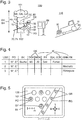
- the method comprises the steps of dividing the tree 101 and / or the environment 110 into one of at least two, in particular deposited, groups GF, GR of the information category IK based on the categorized information Info. Displaying the detected position PO in a, in particular digital, card 120, as in Fig. 5 to recognize, with the group division, in particular by means of the smartphone 80, the tablet computer, if available, and / or the output device 85th
- the trees 101 which require a rope assisted precipitation, are classified into the group GF, as in FIG Fig. 5 represented by hatching.
- the other trees 101 of the felling tool information category FK are grouped into another group, not shown.
- additionally or alternatively may be divided into other groups.
- the method comprises the steps of: dividing the tree 101 and / or the environment 110 into the one of at least two groups GF, GR of the information category IK based on the categorized information Info. Selecting one of the groups GF, in particular by means of the smartphone 80, of the tablet computer, if present and / or of the user-operable operating element 70. outputting a not shown route guidance to the, in particular at least one, detected position PO of the selected group GF, in particular by means of the smartphone 80, of the tablet computer, if any, and / or the output device 85.
- the group GF can be selected for rope-assisted precipitation.
- the information that a rope-assisted precipitation is required can be output.
- the invention provides an advantageous method for documenting at least one piece of information about at least one tree and / or environment of the tree and an advantageous documentation system for documenting at least one piece of information about at least one tree and / or environment of the tree ready to document each facilitated, in particular user-friendly, and allows easy use of the document.
Landscapes
- Engineering & Computer Science (AREA)
- Physics & Mathematics (AREA)
- Business, Economics & Management (AREA)
- Health & Medical Sciences (AREA)
- Mining & Mineral Resources (AREA)
- General Health & Medical Sciences (AREA)
- Acoustics & Sound (AREA)
- Multimedia (AREA)
- Life Sciences & Earth Sciences (AREA)
- Agronomy & Crop Science (AREA)
- Animal Husbandry (AREA)
- Marine Sciences & Fisheries (AREA)
- Audiology, Speech & Language Pathology (AREA)
- Computational Linguistics (AREA)
- Economics (AREA)
- Human Computer Interaction (AREA)
- Human Resources & Organizations (AREA)
- Marketing (AREA)
- Primary Health Care (AREA)
- Strategic Management (AREA)
- Tourism & Hospitality (AREA)
- General Business, Economics & Management (AREA)
- General Physics & Mathematics (AREA)
- Theoretical Computer Science (AREA)
- Telephone Function (AREA)
Abstract
Description
- Die Erfindung bezieht sich auf ein Verfahren zum Dokumentieren mindestens einer Information über mindestens einen Baum und/oder eine Umgebung des Baums und ein Dokumentationssystem zum Dokumentieren mindestens einer Information über mindestens einen Baum und/oder eine Umgebung des Baums.
- Ein Verfahren zum Dokumentieren mindestens einer Information über mindestens einen Baum und/oder eine Umgebung des Baums und ein Dokumentationssystem zum Dokumentieren mindestens einer Information über mindestens einen Baum und/oder eine Umgebung des Baums sind bekannt.
- Der Erfindung liegt als Aufgabe die Bereitstellung eines Verfahrens zum Dokumentieren mindestens einer Information über mindestens einen Baum und/oder eine Umgebung des Baums und eines Dokumentationssystems zum Dokumentieren mindestens einer Information über mindestens einen Baum und/oder eine Umgebung des Baums zugrunde, das jeweils das Dokumentieren erleichtert, insbesondere benutzerfreundlich ist, und ein einfaches Nutzen des Dokumentierten ermöglicht.
- Die Erfindung löst diese Aufgabe durch die Bereitstellung eines Verfahrens mit den Merkmalen des Anspruchs 1. Des Weiteren wird die der Erfindung zugrundeliegende Aufgabe durch ein Dokumentationssystem mit den Merkmalen des Anspruchs 9 gelöst. Vorteilhafte Weiterbildungen und/oder Ausgestaltungen der Erfindung sind in den abhängigen Ansprüchen beschrieben.
- Das erfindungsgemäße, insbesondere automatische, Verfahren zum Dokumentieren mindestens einer Information über mindestens einen Baum, insbesondere seinen Baumstamm, und/oder eine Umgebung, insbesondere ein Umgebungsobjekt, des Baums weist die Schritte auf: a) Erfassen, insbesondere automatisches Erfassen, einer Spracheingabe aufweisend die mindestens eine Information über den Baum und/oder die Umgebung des Baums mit mindestens einem, insbesondere hinterlegten, Forstbegriff. b) Erfassen, insbesondere automatisches Erfassen, einer Position des Baums und/oder der Umgebung mit der Spracheingabe. c) Erkennen, insbesondere automatisches Erkennen, des Forstbegriffs in der erfassten Spracheingabe. d) Zuordnen, insbesondere automatisches Zuordnen, der Information in der erfassten Spracheneingabe einer, insbesondere nur einer einzigen, von mindestens zwei, insbesondere hinterlegten, Informationskategorien basierend auf dem erkannten Forstbegriff. e) Speichern, insbesondere automatisches Speichern, der kategorisierten Information mit der erfassten Position.
- Das Verfahren ermöglicht ein einfaches Dokumentieren. Insbesondere ermöglicht das Erfassen der Spracheingabe, dass ein Benutzer, insbesondere ein Forstarbeiter, seine Hände nicht zum Eingeben der Information braucht. Der Benutzer kann seine Hände für anderes frei haben. Somit ist das Verfahren benutzerfreundlich. Des Weiteren ermöglicht das Verfahren, dass das Dokumentierte, insbesondere die kategorisierte Information mit der erfassten Position, einfach genutzt werden kann, insbesondere für eine Arbeitsplanung bezüglich des Baums und/oder seiner Umgebung oder für eine Zertifizierung des Baums und/oder seiner Umgebung.
- Insbesondere kann das Dokumentieren ein Auszeichnen des mindestens einen Baums aufweisen oder sein.
- Der Baum kann stehend sein, insbesondere lebend. Die Umgebung sich in einem Umkreis von maximal 500 Meter (m) Entfernung von dem Baum erstrecken, insbesondere von maximal 200 m, insbesondere von maximal 100 m, insbesondere von maximal 50 m, insbesondere von maximal 20 m. Der Baum kann ein Baum eines Forsts oder eines Walds sein. Alternativ kann der Baum ein Baum eines Gartens, eines Parks, einer Allee oder etwas anderen sein.
- Unabhängig davon kann zum Dokumentieren für den Baum und/oder die Umgebung des Baums der mindestens eine Forstbegriff verwendet werden. Der Forstbegriff kann als Forstschlüsselbegriff oder Forstwirtschaftsbegriff bezeichnet werden. Der Forstbegriff selbst kann die Information sein. Die Information kann als Forstinformation bezeichnet werden. Die Information kann einen Wert und/oder einen Betrag aufweisen oder sein.
- Die Spracheingabe kann mehrere Informationen mit mehreren zugehörigen Forstbegriffen aufweisen. Jede der mehreren Informationen kann basierend auf dem zugehörigen Forstbegriff der entsprechenden Informationskategorie zugeordnet werden. Beispielsweise kann eine erste Information einer ersten Informationskategorie zugeordnet werden und eine zweite, von der ersten verschiedene Information kann einer zweiten, von der ersten verschiedenen Informationskategorie zugeordnet werden. Die Spracheingabe kann von dem Benutzer gesprochen werden oder sein.
- Die Position kann Koordinaten beziehungsweise einen Wert und/oder einen Betrag der Koordinaten aufweisen oder sein. Insbesondere kann die Position eine Position des Benutzers an dem Baum und/oder in der Umgebung sein.
- Insbesondere kann die Spracheingabe die Position aufweisen. In anderen Worten: der Benutzer kann die Position sprechen, wobei die gesprochene Position erfasst werden kann. Zuvor kann eine Positionsbestimmungseinrichtung die Position an den Benutzer ausgegeben haben.
- Zusätzlich oder alternativ kann die Position getrennt von der Spracheingabe erfasst werden. Anders formuliert: die Spracheingabe braucht nicht die Position aufzuweisen. Insbesondere kann das Erfassen der Position ein Bestimmen, insbesondere ein automatisches Bestimmen, der Position aufweisen oder sein, insbesondere mittels einer mobilen Positionsbestimmungseinrichtung. Das Erfassen der Spracheingabe und das Erfassen der Position kann miteinander zeitnah oder zeitsynchronisiert, insbesondere zeitgleich oder währenddessen, ausgeführt werden. Zeitnah kann bedeuten, dass das Erfassen der Position in einem Zeitraum von maximal 30 Sekunden (s), insbesondere von maximal 10 s, insbesondere von maximal 5 s, insbesondere von maximal 1 s, vor bis nach dem Erfassen der Spracheingabe ausgeführt werden kann. Zeitgleich kann bedeuten, dass das Erfassen der Position zu Beginn, in der Mitte oder zu Ende des Erfassens der Spracheingabe ausgeführt werden kann.
- Der Schritt c) kann zeitgleich mit dem Schritt a) und/oder dem Schritt b) und/oder zeitlich nach diesen/m ausgeführt werden. Der Schritt d) kann zeitgleich mit dem Schritt c) und/oder zeitlich nach diesem ausgeführt werden. Der Schritt e) kann zeitgleich mit dem Schritt d) und/oder zeitlich nach diesem ausgeführt werden.
- Das Verfahren kann für mindestens einen weiteren Baum und/oder eine weitere Umgebung des weiteren Baums, insbesondere mehrfach, wiederholt werden.
- In einer Weiterbildung der Erfindung weist das Verfahren den Schritt auf: Messen mindestens einer Geometrie, insbesondere eines Werts und/oder eines Betrags der Geometrie, des Baums und/oder der Umgebung, insbesondere mittels eines handgeführten Messgeräts. Die Information weist die gemessene Geometrie auf. Der Forstbegriff ist ein geometrischer Forstbegriff beziehungsweise ein Forstbegriff für die Geometrie. Mindestens eine der Informationskategorien ist eine geometrische Informationskategorie. Die Spracheingabe kann ermöglichen, dass der Benutzer seine Hände zum Messen frei hat, insbesondere für das handgeführte Messgerät, soweit vorhanden. Insbesondere kann die Geometrie des Baums einen Durchmesser, insbesondere einen Brusthöhendurchmesser, und/oder eine Höhe und/oder eine Krümmung und/oder eine Neigung und/oder eine Kontur und/oder eine Form und/oder eine Astverteilung und/oder eine Kronenlast des Baums oder seines Baumstamms aufweisen oder sein. Zusätzlich oder alternativ zum Messen kann mindestens ein Teil der Geometrie, wie die Höhe, insbesondere von dem Benutzer, geschätzt oder sogar gezählt werden. Die Forstinformation kann die geschätzte oder gezählte Geometrie aufweisen.
- In einer Weiterbildung der Erfindung weist die Information eine Fällinformation, insbesondere über ein Fällwerkzeug, zum Fällen des Baums auf. Der Forstbegriff ist ein Forstbegriff für die Fällinformation, insbesondere das Fällwerkzeug. Mindestens eine der Informationskategorien ist eine Fäll-Informationskategorie, insbesondere eine Fällwerkzeug-Informationskategorie. Das Fällwerkzeug kann ein Spezial-Fällwerkzeug sein, dass nicht zur Standardausrüstung eines Forstwirts zu gehören braucht, welche er typischerweise immer dabei haben kann, wie eine Axt, eine Säge und/oder Keile. Insbesondere kann das Spezial-Fällwerkzeug eine Seilwinde mit Seil zum seilunterstützten Fällen des Baums sein.
- In einer Weiterbildung der Erfindung weist die Information eine Baumart des Baums auf. Der Forstbegriff ist ein Forstbegriff für die Baumart. Mindestens eine der Informationskategorien ist eine Baumart-Informationskategorie. Insbesondere kann die Baumart Buche, Lärche, Eiche, Fichte oder Kiefer sein. Zusätzlich oder alternativ kann die Baumart Zukunftsbaum beziehungsweise Z-Baum, Samenbaum, Habitatbaum, Höhlenbaum, Horstbaum, Käferbaum, Mahlbaum, Erntebaum, Totholz oder Gassenbaum sein. Ein Gassenbaum kann ein Baum sein, welcher zum Anlegen einer zukünftigen Rückegasse gefällt werden soll.
- In einer Weiterbildung der Erfindung weist die Information eine Qualität und/oder einen Gesundheitszustand des Baums auf. Der Forstbegriff ist ein Forstbegriff für die Qualität und/oder den Gesundheitszustand. Mindestens eine der Informationskategorien ist eine Qualitäts-Informationskategorie und/oder eine Gesundheitszustands-Informationskategorie. Insbesondere kann die Qualität eine Qualitätsklasse wie A, B, C oder 1, 2, 3 oder Furnier oder Wertholz sein. Der Gesundheitszustand kann Schäden, insbesondere Holzschäden und/oder einen Schädlingsbefall, und/oder eine Fäule aufweisen oder durch diese beeinträchtigt beziehungsweise verschlechtert sein.
- In einer Weiterbildung der Erfindung weist die Information ein Gefahren- und/oder Hindernisobjekt und/oder eine Rückegasse der Umgebung auf. Der Forstbegriff ist ein Forstbegriff für das Gefahren- und/oder Hindernisobjekt und/oder die Rückegasse. Mindestens eine der Informationskategorien ist eine Gefahren- und/oder Hindernis-Informationskategorie und/oder eine Rückegassen-Informationskategorie. Insbesondere kann das Gefahren- und/oder Hindernisobjekt einen Hochsitz beziehungsweise ein Drückjagdbock oder ein Biotop aufweisen oder sein. Die Rückegasse kann zum Holen des, insbesondere gefällten, Baums dienen.
- In einer Weiterbildung der Erfindung weist das Verfahren die Schritte auf: Einteilen, insbesondere automatisches Einteilen, des Baums und/oder der Umgebung in eine, insbesondere nur in eine einzige, von mindestens zwei, insbesondere hinterlegten, Gruppen der Informationskategorie basierend auf der kategorisierten Information. Anzeigen, insbesondere automatisches Anzeigen, der erfassten Position in oder auf einer, insbesondere digitalen, Karte mit der Gruppeneinteilung. Die Gruppe kann durch ein spezifisches Gruppenkriterium gekennzeichnet sein. Beispielsweise kann das Einteilen basierend auf dem Erfordernis oder dem Nicht-Erfordernis eines Spezial-Fällwerkzeugs erfolgen. Zusätzlich oder alternativ kann das Einteilen basierend auf der kategorisierten Information einer speziellen Baumart, wie Gassenbaum, erfolgen. Weiter zusätzlich oder alternativ kann das Einteilen basierend auf der kategorisierten Information einer speziellen Qualität und/oder eines speziellen Gesundheitszustands erfolgen. Weiter zusätzlich oder alternativ kann das Einteilen basierend auf der kategorisierten Information eines speziellen Gefahren- und/oder Hindernisobjekts erfolgen. Weiter zusätzlich oder alternativ kann das Einteilen basierend auf dem Erfüllen oder Nicht-Erfüllen Rückegasse erfolgen.
- In einer Weiterbildung der Erfindung weist das Verfahren die Schritte auf: Einteilen, insbesondere automatisches Einteilen, des Baums und/oder der Umgebung in eine, insbesondere nur in eine einzige, von mindestens zwei, insbesondere hinterlegten, Gruppen der Informationskategorie basierend auf der kategorisierten Information. Auswählen, insbesondere automatisches Auswählen, einer der Gruppen. Ausgeben, insbesondere automatisches Ausgeben, einer Routenführung zu der, insbesondere mindestens einen, erfassten Position der ausgewählten Gruppe. Die Gruppe kann durch ein spezifisches Gruppenkriterium gekennzeichnet sein. Beispielsweise kann das Einteilen basierend auf dem Erfordernis oder dem Nicht-Erfordernis eines Spezial-Fällwerkzeugs erfolgen. Zusätzlich oder alternativ kann das Einteilen basierend auf der kategorisierten Information einer speziellen Baumart, wie Gassenbaum, erfolgen. Weiter zusätzlich oder alternativ kann das Einteilen basierend auf der kategorisierten Information einer speziellen Qualität und/oder eines speziellen Gesundheitszustands erfolgen. Weiter zusätzlich oder alternativ kann das Einteilen basierend auf der kategorisierten Information eines speziellen Gefahren- und/oder Hindernisobjekts erfolgen. Weiter zusätzlich oder alternativ kann das Einteilen basierend auf dem Erfüllen oder Nicht-Erfüllen Rückegasse erfolgen. Zusätzlich kann die kategorisierte Information und/oder das Gruppenkriterium, soweit vorhanden, ausgegeben werden. Die Routenführung kann optisch, akustisch und/oder haptisch ausgegeben werden. Insbesondere kann das optische Ausgeben ein Anzeigen aufweisen. Das haptische Ausgeben kann ein Vibrieren aufweisen.
- Des Weiteren bezieht sich die Erfindung auf ein Dokumentationssystem zum Dokumentieren der mindestens einen Information über den mindestens einen Baum und/oder die Umgebung des Baums. Das Dokumentationssystem kann insbesondere zum Ausführen des zuvor beschriebenen Verfahrens ausgebildet sein. Das erfindungsgemäße Dokumentationssystem weist eine mobile, insbesondere elektrische, Erfassungseinrichtung, eine mobile, insbesondere elektrische, Positionserfassungseinrichtung, eine, insbesondere elektrische, Erkennungseinrichtung, eine, insbesondere elektrische, Zuordnungseinrichtung und eine, insbesondere elektrische, Speichereinrichtung auf. Die mobile Erfassungseinrichtung ist zum Erfassen der Spracheingabe aufweisend die mindestens eine Information über den Baum und/oder die Umgebung des Baums mit dem mindestens einen Forstbegriff ausgebildet. Die mobile Positionserfassungseinrichtung ist zum Erfassen der Position des Baums und/oder der Umgebung mit der Spracheingabe ausgebildet. Die Erkennungseinrichtung ist zum Erkennen des Forstbegriffs in der erfassten Spracheingabe ausgebildet. Die Zuordnungseinrichtung ist zum Zuordnen der Information in der erfassten Spracheneingabe einer von den mindestens zwei Informationskategorien basierend auf dem erkannten Forstbegriff ausgebildet. Die Speichereinrichtung ist zum Speichern der kategorisierten Information mit der erfassten Position ausgebildet.
- Das Dokumentationssystem kann die gleichen Vorteile ermöglichen wie das zuvor beschriebene Verfahren.
- Mobil kann als portabel oder handgeführt, insbesondere handgetragen, bezeichnet werden.
- Die mobile Erfassungseinrichtung kann ein Mikrophon aufweisen. Insbesondere kann das Dokumentationssystem ein Headset, insbesondere ein Bluetooth-Headset, mit dem Mikrophon aufweisen.
- Die mobile Erfassungseinrichtung und die mobile Positionserfassungseinrichtung können dieselbe Einrichtung sein, insbesondere zum Erfassen der Spracheingabe aufweisend die Position. Zusätzlich oder alternativ kann die mobile Positionserfassungseinrichtung getrennt von der mobilen Erfassungseinrichtung ausgebildet sein, insbesondere zum Erfassen der Position getrennt von der Spracheingabe. Die mobile Erfassungseinrichtung und/oder die mobile Positionserfassungseinrichtung können/kann dazu ausgebildet sein oder miteinander derart zusammen wirken beziehungsweise derart gekoppelt sein, das Erfassen der Spracheingabe und das Erfassen der Position miteinander zeitnah oder zeitsynchronisiert auszuführen. Insbesondere kann die Positionserfassungseinrichtung die mobile Positionsbestimmungseinrichtung zum Bestimmen der Position aufweisen oder sein. Die mobile Positionsbestimmungseinrichtung kann einen Satelliten-Positionsbestimmungsempfänger aufweisen oder sein. Der Satelliten-Positionsbestimmungsempfänger kann für eines oder mehrere Satelliten-Positionsbestimmungssysteme wie NAVSTAR GPS, GLONASS, Galileo und/oder BeiDou ausgebildet sein.
- Die Erkennungseinrichtung und/oder die Zuordnungseinrichtung können/kann einen Prozessor, insbesondere eine CPU, aufweisen oder sein.
- Die Speichereinrichtung kann eine Festplatte und/oder ein Wechselspeichermedium aufweisen oder sein. Zusätzlich kann die Speichereinrichtung eine elektronische Speichereinrichtung, insbesondere eine Halbleiterspeichereinrichtung, und/oder eine magnetische Speichereinrichtung und/oder eine optische Speichereinrichtung aufweisen oder sein.
- In einer Weiterbildung der Erfindung weist das Dokumentationssystem das handgeführte, insbesondere handgetragene, Messgerät auf. Das Messgerät ist zum Messen der mindestens einen Geometrie des Baums und/oder der Umgebung ausgebildet. Die Information weist die gemessene Geometrie auf. Der Forstbegriff ist der geometrische Forstbegriff. Mindestens eine der Informationskategorien ist die geometrische Informationskategorie. Handgeführtes, insbesondere handgetragenes, Messgerät kann bedeuten, dass das Messgerät eine maximale Masse von 50 Kilogramm (kg), insbesondere von 20 kg, insbesondere von 10 kg, aufweisen kann.
- In einer Ausgestaltung der Erfindung ist das handgeführte Messgerät eine Kluppe. Die Kluppe ist zum Messen eines Durchmessers des Baums ausgebildet. Die Information weist den gemessenen Durchmesser auf. Der Forstbegriff ist ein Forstbegriff für den Durchmesser. Die Informationskategorie ist eine Durchmesser-Informationskategorie.
- In einer Weiterbildung der Erfindung weist das Dokumentationssystem ein mobiles benutzerbetätigbares, insbesondere elektrisches, Auslöserelement auf. Das Auslöserelement ist zur, insbesondere lösbaren, Befestigung an einem mobilen Gerät ausgebildet, insbesondere an dem handgeführten Messgerät, soweit vorhanden. Das Auslöserelement ist zur kabellosen Verbindung mit der mobilen Erfassungseinrichtung zum Auslösen des Erfassens der Spracheingabe und/oder mit der mobilen Positionserfassungseinrichtung zum Auslösen des Erfassens der Position ausgebildet. Insbesondere kann das mobile benutzerbetätigbare Auslöserelement getrennt von der mobilen Erfassungseinrichtung und/oder der mobilen Positionserfassungseinrichtung ausgebildet sein. Das mobile benutzerbetätigbare Auslöserelement kann einen Taster beziehungsweise einen Druckknopf aufweisen oder sein. Die kabellose Verbindung kann eine Bluetooth- und/oder eine WLAN-Verbindung sein. Zusätzlich oder alternativ kann das Dokumentationssystem beziehungsweise seine mobile Erfassungseinrichtung zur Sprachsteuerung ausgebildet sein, insbesondere zum Auslösen des Erfassens der Spracheingabe und/oder des Erfassens der Position in Abhängigkeit von einem Sprachbefehl.
- In einer Weiterbildung der Erfindung weist das Dokumentationssystem ein Smartphone auf. Die mobile Positionserfassungseinrichtung ist getrennt von dem Smartphone ausgebildet. Zusätzlich oder alternativ weist das Dokumentationssystem einen Tabletcomputer auf. Die mobile Positionserfassungseinrichtung ist getrennt von dem Tabletcomputer ausgebildet. Typischerweise können/kann das Smartphone und/oder der Tabletcomputer selbst eine integrierte Positionserfassungseinrichtung, insbesondere einen integrierten Satelliten-Positionsbestimmungsempfänger, aufweisen, welche in der Regel relativ ungenau in der Position sein kann oder ist. Die getrennte Ausbildung kann eine genauere Positionserfassung, insbesondere Positionsbestimmung, ermöglichen. Die mobile Positionserfassungseinrichtung kann als GPS-Verstärker bezeichnet werden. Die mobile Positionserfassungseinrichtung kann zur, insbesondere lösbaren, Verbindung oder Kopplung mit dem Smartphone und/oder dem Tabletcomputer ausgebildet sein.
- In einer Weiterbildung der Erfindung weist das Dokumentationssystem eine mobile, insbesondere elektrische, Zwischenspeichereinrichtung auf. Die mobile Zwischenspeichereinrichtung ist zum Zwischenspeichern der erfassten Spracheingabe und/oder der erfassten Position ausgebildet. Die mobile Zwischenspeichereinrichtung ist zur Übertragung der zwischengespeicherten Spracheingabe an die Erkennungseinrichtung und/oder der zwischengespeicherten Position an die Speichereinrichtung ausgebildet. Insbesondere kann die mobile Zwischenspeichereinrichtung getrennt von der Erkennungseinrichtung, der Zuordnungseinrichtung und/oder der Speichereinrichtung ausgebildet sein. Die mobile Zwischenspeichereinrichtung und zusätzlich die Erkennungseinrichtung, die Zuordnungseinrichtung und/oder die Speichereinrichtung können jeweils eine Übertragungseinrichtung zur Übertragung aufweisen. Die Übertragung kann eine UMTS-, WLAN-, und/oder Bluetooth-Übertragung sein. Das Dokumentationssystem kann ein Smartphone und/oder einen Tabletcomputer aufweisen, welches/r die Zwischenspeichereinrichtung aufweisen kann. Die Zwischenspeichereinrichtung kann eine Festplatte und/oder ein Wechselspeichermedium aufweisen oder sein. Zusätzlich kann die Zwischenspeichereinrichtung eine elektronische Speichereinrichtung, insbesondere eine Halbleiterspeichereinrichtung, und/oder eine magnetische Speichereinrichtung und/oder eine optische Speichereinrichtung aufweisen oder sein.
- In einer Weiterbildung der Erfindung weist das Dokumentationssystem eine, insbesondere elektrische, Ausgabeeinrichtung auf. Die Ausgabeeinrichtung ist zum Ausgeben, insbesondere zum Anzeigen, der kategorisierten Information mit der erfassten Position ausgebildet. Insbesondere kann die Ausgabeeinrichtung eine Anzeige und/oder einen Schallerzeuger und/oder eine Vibrationseinrichtung aufweisen oder sein.
- Weitere Vorteile und Aspekte der Erfindung ergeben sich aus den Ansprüchen und aus der nachfolgenden Beschreibung von bevorzugten Ausführungsbeispielen der Erfindung, die nachfolgend anhand der Figuren erläutert sind. Dabei zeigen:
- Fig. 1
- ein Ablaufdiagramm eines erfindungsgemäßen Verfahrens,
- Fig. 2
- ein erfindungsgemäßes Dokumentationssystem,
- Fig. 3
- einen Baum und eine Umgebung des Baums beim Dokumentieren mittels des Verfahrens der
Fig. 1 und des Dokumentationssystems derFig. 2 , - Fig. 4
- eine Tabelle mit mindestens einer kategorisierten Information und mindestens einer erfassten Position und
- Fig. 5
- eine Karte mit einer erfassten Position und einer Gruppeneinteilung.
-
Fig. 1 zeigt ein erfindungsgemäßes Verfahren zum Dokumentieren mindestens einer Information Info über mindestens einen Baum 101 und/oder eine Umgebung 110 des Baums 101, insbesondere eines Forsts 100, wie inFig. 3 zu erkennen. Das Verfahren weist die Schritte auf: a) Erfassen einer Spracheingabe SE aufweisend die mindestens eine Information Info über den Baum 101 und/oder die Umgebung 110 des Baums 101 mit mindestens einem Forstbegriff FB. b) Erfassen einer Position PO des Baums 101 und/oder der Umgebung 110 mit der Spracheingabe SE. c) Erkennen des Forstbegriffs FB in der erfassten Spracheingabe SE. d) Zuordnen der Information Info in der erfassten Spracheneingabe SE einer von mindestens zwei Informationskategorien IK basierend auf dem erkannten Forstbegriff FB. e) Speichern der kategorisierten Information Info mit der erfassten Position PO. -
Fig. 2 zeigt ein erfindungsgemäßes Dokumentationssystem 10 zum Dokumentieren der mindestens einen Information Info über den mindestens einen Baum 101 und/oder die Umgebung 110 des Baums 101. Das Dokumentationssystem 10 ist insbesondere zum Ausführen des zuvor beschriebenen Verfahrens ausgebildet. Das Dokumentationssystem 10 weist eine mobile Erfassungseinrichtung 20, eine mobile Positionserfassungseinrichtung 30, eine Erkennungseinrichtung 40, eine Zuordnungseinrichtung 50 und eine Speichereinrichtung 60 auf. Die mobile Erfassungseinrichtung 20 ist zum Erfassen der Spracheingabe SE aufweisend die mindestens eine Information Info über den Baum 101 und/oder die Umgebung 110 des Baums 101 mit dem mindestens einen Forstbegriff FB ausgebildet. Die mobile Positionserfassungseinrichtung 30 ist zum Erfassen der Position PO des Baums 101 und/oder der Umgebung 110 mit der Spracheingabe SE ausgebildet. Die Erkennungseinrichtung 40 ist zum Erkennen des Forstbegriffs FB in der erfassten Spracheingabe SE ausgebildet. Die Zuordnungseinrichtung 50 ist zum Zuordnen der Information Info in der erfassten Spracheneingabe SE einer von den mindestens zwei Informationskategorien IK basierend auf dem erkannten Forstbegriff FB ausgebildet. Die Speichereinrichtung 60 ist zum Speichern der kategorisierten Information Info mit der erfassten Position PO ausgebildet. - Im gezeigten Ausführungsbeispiel ist die mobile Positionserfassungseinrichtung 30 getrennt von der mobilen Erfassungseinrichtung 20 ausgebildet. Die mobile Positionserfassungseinrichtung 30 ist eine mobile Positionsbestimmungseinrichtung in Form eines Satelliten-Positionsbestimmungsempfängers 31 zum Bestimmen der Position PO. Das Erfassen der Position PO ist ein Bestimmen der Position, insbesondere mittels der mobilen Positionsbestimmungseinrichtung 30.
- In alternativen Ausführungsbeispielen kann die Spracheingabe die Position aufweisen. Die mobile Erfassungseinrichtung und die mobile Positionserfassungseinrichtung können dieselbe Einrichtung sein, insbesondere zum Erfassen der Spracheingabe aufweisend die Position.
- Im Detail weist das Dokumentationssystem 10 ein Smartphone 80 auf. In alternativen Ausführungsbeispielen kann das Dokumentationssystem zusätzlich oder alternativ einen Tabletcomputer aufweisen. Die mobile Positionserfassungseinrichtung 30 ist getrennt von dem Smartphone 80 ausgebildet. Die mobile Positionserfassungseinrichtung 30 ist zur, insbesondere lösbaren, Verbindung mit dem Smartphone 80 ausgebildet, beispielsweise mittels einer Mikro-USB-Schnittstelle.
- Im gezeigten Ausführungsbeispiel ist die mobile Erfassungseinrichtung 20 ein Bluetooth-Headset mit einem Mikrophon. Die mobile Erfassungseinrichtung 20 und das Smartphone 80 sind zu einer Bluetooth-Verbindung miteinander ausgebildet. In alternativen Ausführungsformen kann ein Mikrophon des Smartphones als mobile Erfassungseinrichtung dienen.
- Des Weiteren weist das Dokumentationssystem 10 eine mobile Zwischenspeichereinrichtung 81 auf. Im gezeigten Ausführungsbeispiel weist das Smartphone 80 die mobile Zwischenspeichereinrichtung 81 auf. Die mobile Zwischenspeichereinrichtung 81 ist zum Zwischenspeichern der erfassten Spracheingabe SE und der erfassten Position PO ausgebildet. Die mobile Zwischenspeichereinrichtung 81 ist zur Übertragung der zwischengespeicherten Spracheingabe SE an die Erkennungseinrichtung 40 und der zwischengespeicherten Position PO an die Speichereinrichtung 60 ausgebildet.
- Außerdem weist das Dokumentationssystem 10 ein mobiles benutzerbetätigbares Auslöserelement 75 in Form eines Tasters auf. Das Auslöserelement 75 ist zur, insbesondere lösbaren, Befestigung an einem mobilen Gerät 70, 71 ausgebildet. Das Auslöserelement 75 ist zur kabellosen Verbindung mit der mobilen Erfassungseinrichtung 20 zum Auslösen des Erfassens der Spracheingabe SE und mit der mobilen Positionserfassungseinrichtung 30 zum Auslösen des Erfassens der Position PO ausgebildet.
- Im Detail sind das mobile benutzerbetätigbare Auslöserelement 75 und das Smartphone 80 zu einer Bluetooth-Verbindung miteinander ausgebildet. Bei einem Betätigen des Auslöserelements 75 wird mittels des Smartphones 80 oder über dieses das Erfassen der Spracheingabe SE und das Erfassen der Position PO ausgelöst. Somit wird das Erfassen der Spracheingabe SE und das Erfassen der Position PO miteinander zeitnah ausgeführt.
- Insbesondere wird mit dem Betätigen des Auslöserelements 75 die Position PO bestimmt. Gleichzeitig wird mit dem Erfassen der Spracheingabe SE begonnen. Das Erfassen der Spracheingabe SE wird durch ein erneutes Betätigen des Auslöserelements 75 beendet. Zusätzlich oder alternativ kann das Erfassen der Spracheingabe, insbesondere automatisch, beendet werden, nach einem bestimmten Zeitraum ohne Spracheingabe, beispielsweise nach zehn Sekunden (s), insbesondere nach fünf s, insbesondere nach zwei s.
- In alternativen Ausführungsbeispielen kann das Dokumentationssystem beziehungsweise seine mobile Erfassungseinrichtung zusätzlich oder alternativ zur Sprachsteuerung ausgebildet sein, insbesondere zum Auslösen des Erfassens der Spracheingabe und/oder des Erfassens der Position in Abhängigkeit von einem Sprachbefehl.
- Weiter weist das Dokumentationssystem 10 eine Ausgabeeinrichtung 85 in Form eines in einen Desktopcomputer 86 integrierten Bildschirms auf. Die Ausgabeeinrichtung 85 ist zum Ausgeben, insbesondere zum Anzeigen, der kategorisierten Information Info mit der erfassten Position PO ausgebildet, wie in
Fig. 4 und 5 zu erkennen. Zusätzlich weist das Dokumentationssystem 10 ein benutzerbetätigbares Bedienelement 87 in Form einer Computertastatur und einer Computermaus zum Bedienen der Ausgabeeinrichtung 85 beziehungsweise des Desktopcomputers 86 auf. - Im gezeigten Ausführungsbeispiel sind die Erkennungseinrichtung 40, die Zuordnungseinrichtung 50 und die Speichereinrichtung 60 als mindestens ein Server beziehungsweise ein Netzwerk ausgebildet, insbesondere einer Cloud. In alternativen Ausführungsbeispielen können/kann das Smartphone, der Tabletcomputer, soweit vorhanden, und/oder der Desktopcomputer zusätzlich oder alternativ die Erkennungseinrichtung, die Zuordnungseinrichtung und/oder die Speichereinrichtung aufweisen.
- Das Smartphone 80 beziehungsweise seine mobile Zwischenspeichereinrichtung 81 und der Desktopcomputer 86 sind zur Übertragung der zwischengespeicherten Spracheingabe SE und der zwischengespeicherten Position PO und der kategorisierten Information Info mit der erfassten Position PO miteinander ausgebildet, insbesondere mittels WLAN-, und/oder Bluetooth-Übertragung. Der Desktopcomputer 86 und die Erkennungseinrichtung 40, die Zuordnungseinrichtung 50 und die Speichereinrichtung 60 sind zur Übertragung der Spracheingabe SE und der Position PO und der kategorisierten Information Info mit der erfassten Position PO ausgebildet, insbesondere mittels Internet-Übertragung. Zusätzlich sind das Smartphone 80 beziehungsweise seine mobile Zwischenspeichereinrichtung 81 und die Erkennungseinrichtung 40, die Zuordnungseinrichtung 50 und die Speichereinrichtung 60 zur Übertragung der Spracheingabe SE und der Position PO und der kategorisierten Information Info mit der erfassten Position PO ausgebildet, insbesondere mittels UMTS-Übertragung.
- In der Erkennungseinrichtung 40 und zusätzlich in der Zuordnungseinrichtung 50 ist der mindestens eine Forstbegriff FB hinterlegt. In der Zuordnungseinrichtung 50 sind die mindestens zwei Informationskategorien IK hinterlegt. Mittels des Smartphones 80, des Tabletcomputers, soweit vorhanden, und /oder des Desktopcomputers 86 beziehungsweise des benutzerbetätigbaren Bedienelements 87 kann mindestens ein weiterer Forstbegriff FB und/oder mindestens eine weiter Informationskategorie angelegt beziehungsweise hinterlegt oder editiert werden, insbesondere durch einen Benutzer 200.
- Zudem weist das Dokumentationssystem ein handgeführtes, insbesondere handgetragenes, Messgerät 70 auf. Das Messgerät 70 ist zum Messen mindestens einer Geometrie GE, BD des Baums 101 ausgebildet, insbesondere durch den Benutzer 200, wie in
Fig. 3 zu erkennen. In alternativen Ausführungsbeispielen kann das Messgerät zusätzlich oder alternativ zum Messen mindestens einer Geometrie der Umgebung ausgebildet sein. Die Information Info weist die gemessene Geometrie GE, BD auf. Der Forstbegriff FB ist ein geometrischer Forstbegriff GB. Mindestens eine der Informationskategorien IK ist eine geometrische Informationskategorie GK. - Im Detail ist das handgeführte Messgerät 70 eine Kluppe 71. Die Kluppe 71 ist zum Messen eines Durchmessers BD des Baums 101 beziehungsweise seines Baumstamms 102 ausgebildet. Die Information Info weist den gemessenen Durchmesser BD auf. Der Forstbegriff FB, GB ist ein Forstbegriff für den Durchmesser BD, beispielsweise Durchmesser, Baumdurchmesser oder Brusthöhendurchmesser beziehungsweise jeweils eine Abkürzung dafür. Die Informationskategorie IK, GK ist eine Durchmesser-Informationskategorie DGK.
- Im gezeigten Ausführungsbeispiel ist das mobile benutzerbetätigbare Auslöserelement 75 an dem handgeführten Messgerät 70 in Form der Kluppe 71 befestigt. In alternativen Ausführungsbeispielen kann das mobile benutzerbetätigbare Auslöserelement an einem anderen mobilen Gerät befestigt sein, beispielsweise einer Farbspraydose zum Markieren des Baums und/oder der Umgebung.
- Das Verfahren weist den Schritt auf: Messen der mindestens einen Geometrie GE, BD des Baums 101, insbesondere mittels des handgeführten Messgeräts 70. In alternativen Ausführungsbeispielen kann das Verfahren zusätzlich oder alternativ den Schritt aufweisen: messen mindestens einer Geometrie der Umgebung.
- Im Detail weist das Verfahren den Schritt auf: Messen des Durchmessers BD des Baums 101 beziehungsweise seines Baumstamms 102, insbesondere mittels der Kluppe 71.
- Zusätzlich zum Messen wird mindestens ein Teil der Geometrie GE geschätzt, insbesondere durch den Benutzer 200. Im gezeigten Ausführungsbeispiel wird die Höhe BH des Baums 101 geschätzt. Die Information Info weist die geschätzte Geometrie GE beziehungsweise die Baumhöhe BH auf. Der Forstbegriff ist ein Forstbegriff für die Geometrie GE beziehungsweise die Baumhöhe BH, beispielsweise Höhe oder Baumhöhe beziehungsweise jeweils eine Abkürzung dafür. Mindestens eine der Informationskategorien IK ist eine geometrische Informationskategorie GK beziehungsweise eine Höhen-Informationskategorie HGK.
- Des Weiteren weist die Information Info eine Fällinformation, insbesondere über ein Fällwerkzeug 90, zum Fällen des Baums 101 auf. Der Forstbegriff FB ist ein Forstbegriff für die Fällinformation, insbesondere das Fällwerkzeug 90, beispielsweise Seilwinde oder seilunterstütze Fällung beziehungsweise jeweils eine Abkürzung dafür. Mindestens eine der Informationskategorien IK ist eine Fäll-Informationskategorie, insbesondere eine Fällwerkzeug-Informationskategorie FK. Im gezeigten Ausführungsbeispiel ist das Fällwerkzeug 90 in Form der Seilwinde an einem Holfahrzeug 91 in Form eines Traktors angeordnet.
- Außerdem weist die Information Info eine Baumart BA des Baums 101 auf. Der Forstbegriff FB ist ein Forstbegriff für die Baumart BA, beispielsweise Gassenbaum, Zukunftsbaum, Buche, Lärche oder Totholz beziehungsweise jeweils eine Abkürzung dafür. Mindestens eine der Informationskategorien IK ist eine Baumart-Informationskategorie BK.
- Weiter weist die Information eine Qualität QA und/oder einen Gesundheitszustand GZ des Baums 101 auf. Der Forstbegriff FB ist ein Forstbegriff für die Qualität QA und/oder den Gesundheitszustand GZ, beispielsweise Furnier oder Wertholz und/oder Schäden oder Fäule beziehungsweise jeweils eine Abkürzung dafür. Mindestens eine der Informationskategorien IK ist eine Qualitäts-Informationskategorie QK und/oder eine Gesundheitszustands-Informationskategorie GZK.
- Zudem weist die Information Info ein Gefahren- und/oder Hindernisobjekt GH und/oder eine Rückegasse RG der Umgebung 110 auf. Der Forstbegriff FB ist ein Forstbegriff für das Gefahren- und/oder Hindernisobjekt GH und/oder die Rückegasse RG, beispielsweise Hochsitz und/oder Rückegasse beziehungsweise jeweils eine Abkürzung dafür. Mindestens eine der Informationskategorien IK ist eine Gefahren- und/oder Hindernis-Informationskategorie GHK und/oder eine Rückegassen-Informationskategorie RK.
- Im gezeigten Ausführungsbeispiel sind mehr als zwei Informationskategorien IK vorhanden, insbesondere sechs, wie in den Spalten der Tabelle der
Fig. 4 zu erkennen. Die Informationskategorien IK sind die Baumart-Informationskategorie BK, die Durchmesser-Informationskategorie DGK, die Höhen-Informationskategorie HGK, die Fällwerkzeug-Informationskategorie FK, die Qualitäts- und Gesundheitszustands-Informationskategorie QK/GZK und die Gefahren- und/oder Hindernis- und Rückegassen-Informationskategorie GHK/RK. In alternativen Ausführungsbeispielen kann zusätzlich oder alternativ mindestens eine andere Informationskategorie vorgesehen oder vorhanden sein. Weiter können in alternativen Ausführungsbeispielen zwei, drei, vier, fünf, sieben, acht, neun, zehn oder mehr als zehn Informationskategorien vorgesehen oder vorhanden sein. Zusätzlich weist die Tabelle eine Spalte zur Nummerierung der Spracheingaben SE auf. Weiter zusätzlich weist die Tabelle eine Spalte für die jeweils erfasste Position PO beziehungsweise ihre Koordinaten auf. - Zum Dokumentieren des in
Fig. 3 gezeigten Baums 101 geht der Benutzer 200 zu dem Baum 101 mit der mobilen Erfassungseinrichtung 20, der mobilen Positionserfassungseinrichtung 30, dem handgeführten Messgerät 70 in Form der Kluppe 71, dem daran befestigten mobilen benutzerbetätigbaren Auslöserelement 75 und dem Smartphone 80. Dort misst er die mindestens eine Geometrie GE des Baums 101 in Form des Durchmessers BD. Des Weiteren schätzt er die Höhe BH des Baums 101. Außerdem beurteilt er, ob das Fällwerkzeug 90 zum Fällen erforderlich ist, die Baumart BA, die Qualität QA und/oder den Gesundheitszustand GZ. Dabei betätigt er das mobile benutzerbetätigbare Auslöserelement 75 und spricht beispielsweise die Spracheingabe SE: Buche, BHD 65, Höhe 20, seilunterstütze Fällung, Furnier. Dabei kann mit 65 die Einheit Zentimeter und/oder mit 20 die Einheit Meter implizit eingeschlossen sein. - Dann kann das Verfahren für die Umgebung 110 des Baums 101, mindestens einen weiteren Baum 101 und/oder eine weitere Umgebung 110 des weiteren Baums 101 wiederholt werden.
- Zum Dokumentieren des Gefahren- und/oder Hindernisobjekts GH in Form des Hochsitzes der Umgebung 110 geht der Benutzer 200 zu dem Gefahren- und/oder Hindernisobjekt GH und spricht dort beispielsweise die weitere Spracheingabe SE: Hochsitz.
- Zum Dokumentieren der Rückegasse RG in der Umgebung 110 geht der Benutzer 200 zu der Rückegasse RG, und diese insbesondere entlang, und spricht dort beispielsweise die weitere/n Spracheingabe/n SE: Rückegasse.
- Des Weiteren weist das Verfahren die Schritte auf: Einteilen des Baums 101 und/oder der Umgebung 110 in eine von mindestens zwei, insbesondere hinterlegten, Gruppen GF, GR der Informationskategorie IK basierend auf der kategorisierten Information Info. Anzeigen der erfassten Position PO in einer, insbesondere digitalen, Karte 120, wie in
Fig. 5 zu erkennen, mit der Gruppeneinteilung, insbesondere mittels des Smartphone 80, des Tabletcomputers, soweit vorhanden, und/oder der Ausgabeeinrichtung 85. - Im gezeigten Ausführungsbeispiel werden die Bäume 101, welche eine seilunterstütze Fällung erfordern, in die Gruppe GF eingeteilt, wie in
Fig. 5 durch Schraffur dargestellt. Die anderen Bäume 101 der Fällwerkzeug-Informationskategorie FK werden in eine andere, nicht dargestellte Gruppe eingeteilt. Des Weiteren werden die Rückegassen RG beziehungsweise ihre Zeilen der Tabelle derFig. 4 mit einem Eintrag Rückegasse in der Rückegassen-Informationskategorie RK in die Gruppe GR eingeteilt, wie inFig. 5 durch Kreuze dargestellt. In alternativen Ausführungsbeispielen kann zusätzlich oder alternativ in andere Gruppen eingeteilt werden. - Außerdem weist das Verfahren die Schritte auf: das Einteilen des Baums 101 und/oder der Umgebung 110 in die eine von mindestens zwei Gruppen GF, GR der Informationskategorie IK basierend auf der kategorisierten Information Info. Auswählen einer der Gruppen GF insbesondere mittels des Smartphones 80, des Tabletcomputers, soweit vorhanden und/oder des benutzerbetätigbaren Bedienelements 70. Ausgeben einer nicht dargestellten Routenführung zu der, insbesondere mindestens einen, erfassten Position PO der ausgewählten Gruppe GF, insbesondere mittels des Smartphones 80, des Tabletcomputers, soweit vorhanden, und/oder der Ausgabeeinrichtung 85. Beispielsweise kann die Gruppe GF für seilunterstütze Fällung ausgewählt werden. Zusätzlich kann die Information, dass eine seilunterstütze Fällung erforderlich ist, ausgegeben werden.
- Wie die gezeigten und oben erläuterten Ausführungsbeispiele deutlich machen, stellt die Erfindung ein vorteilhaftes Verfahren zum Dokumentieren mindestens einer Information über mindestens einen Baum und/oder eine Umgebung des Baums und ein vorteilhaftes Dokumentationssystem zum Dokumentieren mindestens einer Information über mindestens einen Baum und/oder eine Umgebung des Baums bereit, das jeweils das Dokumentieren erleichtert, insbesondere benutzerfreundlich ist, und ein einfaches Nutzen des Dokumentierten ermöglicht.
Claims (15)
- Verfahren zum Dokumentieren mindestens einer Information (Info) über mindestens einen Baum (101) und/oder eine Umgebung (110) des Baums (101), wobei das Verfahren die Schritte aufweist:a) Erfassen einer Spracheingabe (SE) aufweisend die mindestens eine Information (Info) über den Baum (101) und/oder die Umgebung (110) des Baums (101) mit mindestens einem Forstbegriff (FB),b) Erfassen einer Position (PO) des Baums (101) und/oder der Umgebung (110) mit der Spracheingabe (SE),c) Erkennen des Forstbegriffs (FB) in der erfassten Spracheingabe (SE),d) Zuordnen der Information (Info) in der erfassten Spracheneingabe (SE) einer von mindestens zwei Informationskategorien (IK) basierend auf dem erkannten Forstbegriff (FB) unde) Speichern der kategorisierten Information (Info) mit der erfassten Position (PO).
- Verfahren nach Anspruch 1,- aufweisend den Schritt: Messen mindestens einer Geometrie (GE, BD) des Baums (101) und/oder der Umgebung,- wobei die Information (Info) die gemessene Geometrie (GE, BD) aufweist,- wobei der Forstbegriff (FB) ein geometrischer Forstbegriff (GB) ist und- wobei mindestens eine der Informationskategorien (IK) eine geometrische Informationskategorie (GK) ist.
- Verfahren nach einem der vorhergehenden Ansprüche,- wobei die Information (Info) eine Fällinformation, insbesondere über ein Fällwerkzeug (90), zum Fällen des Baums (101) aufweist,- wobei der Forstbegriff (FB) ein Forstbegriff für die Fällinformation, insbesondere das Fällwerkzeug (90), ist und- wobei mindestens eine der Informationskategorien (IK) eine Fäll-Informationskategorie, insbesondere eine Fällwerkzeug-Informationskategorie (FK), ist.
- Verfahren nach einem der vorhergehenden Ansprüche,- wobei die Information (Info) eine Baumart (BA) des Baums (101) aufweist,- wobei der Forstbegriff (FB) ein Forstbegriff für die Baumart (BA) ist und- wobei mindestens eine der Informationskategorien (IK) eine Baumart-Informationskategorie (BK) ist.
- Verfahren nach einem der vorhergehenden Ansprüche,- wobei die Information (Info) eine Qualität (QA) und/oder einen Gesundheitszustand (GZ) des Baums (101) aufweist,- wobei der Forstbegriff (FB) ein Forstbegriff für die Qualität (QA) und/oder den Gesundheitszustand (GZ) ist und- wobei mindestens eine der Informationskategorien (IK) eine Qualitäts-Informationskategorie (QK) und/oder eine Gesundheitszustands-Informationskategorie (GZK) ist.
- Verfahren nach einem der vorhergehenden Ansprüche,- wobei die Information (Info) ein Gefahren- und/oder Hindernisobjekt (GH) und/oder eine Rückegasse (RG) der Umgebung (110) aufweist,- wobei der Forstbegriff (FB) ein Forstbegriff für das Gefahren- und/oder Hindernisobjekt (GH) und/oder die Rückegasse (RG) ist und- wobei mindestens eine der Informationskategorien (IK) eine Gefahren- und/oder Hindernis-Informationskategorie (GHK) und/oder eine Rückegassen-Informationskategorie (RK) ist.
- Verfahren nach einem der vorhergehenden Ansprüche, aufweisend die Schritte:- Einteilen des Baums (101) und/oder der Umgebung (110) in eine von mindestens zwei Gruppen (GF, GR) der Informationskategorie (IK) basierend auf der kategorisierten Information (Info) und- Anzeigen der erfassten Position (PO) in einer Karte (120) mit der Gruppeneinteilung.
- Verfahren nach einem der vorhergehenden Ansprüche, aufweisend die Schritte:- Einteilen des Baums (101) und/oder der Umgebung (110) in eine von mindestens zwei Gruppen (GF, GR) der Informationskategorie (IK) basierend auf der kategorisierten Information (Info),- Auswählen einer der Gruppen (GF) und- Ausgeben einer Routenführung zu der erfassten Position (PO) der ausgewählten Gruppe (GF).
- Dokumentationssystem (10) zum Dokumentieren mindestens einer Information (Info) über mindestens einen Baum (101) und/oder eine Umgebung (110) des Baums (101), wobei das Dokumentationssystem (10) aufweist:- ein mobile Erfassungseinrichtung (20), welche zum Erfassen einer Spracheingabe (SE) aufweisend die mindestens eine Information (Info) über den Baum (101) und/oder die Umgebung (110) des Baums (101) mit mindestens einem Forstbegriff (FB) ausgebildet ist,- eine mobile Positionserfassungseinrichtung (30), welche zum Erfassen einer Position (PO) des Baums (101) und/oder der Umgebung (110) mit der Spracheingabe (SE) ausgebildet ist,- eine Erkennungseinrichtung (40), welche zum Erkennen des Forstbegriffs (FB) in der erfassten Spracheingabe (SE) ausgebildet ist,- eine Zuordnungseinrichtung (50), welche zum Zuordnen der Information (Info) in der erfassten Spracheneingabe (SE) einer von mindestens zwei Informationskategorien (IK) basierend auf dem erkannten Forstbegriff (FB) ausgebildet ist, und- eine Speichereinrichtung (60), welche zum Speichern der kategorisierten Information (Info) mit der erfassten Position (PO) ausgebildet ist.
- Dokumentationssystem (10) nach Anspruch 9, aufweisend:- ein handgeführtes Messgerät (70), welches zum Messen mindestens einer Geometrie (GE, BD) des Baums (101) und/oder der Umgebung ausgebildet ist,- wobei die Information (Info) die gemessene Geometrie (GE, BD) aufweist,- wobei der Forstbegriff (FB) ein geometrischer Forstbegriff (GB) ist und- wobei mindestens eine der Informationskategorien (IK) eine geometrische Informationskategorie (GK) ist.
- Dokumentationssystem (10) nach Anspruch 10,- wobei das handgeführte Messgerät (70) eine Kluppe (71) ist, welche zum Messen eines Durchmessers (BD) des Baums (101) ausgebildet ist,- wobei die Information (Info) den gemessenen Durchmesser (BD) aufweist,- wobei der Forstbegriff (FB, GB) ein Forstbegriff für den Durchmesser (BD) ist und- wobei die Informationskategorie (IK, GK) eine Durchmesser-Informationskategorie (DGK) ist.
- Dokumentationssystem (10) nach einem der Ansprüche 9 bis 11, aufweisend:- ein mobiles benutzerbetätigbares Auslöserelement (75), welches zur Befestigung an einem mobilen Gerät (70, 71) ausgebildet ist und welches zur kabellosen Verbindung mit der mobilen Erfassungseinrichtung (20) zum Auslösen des Erfassens der Spracheingabe (SE) und/oder mit der mobilen Positionserfassungseinrichtung (30) zum Auslösen des Erfassens der Position (PO) ausgebildet ist.
- Dokumentationssystem (10) nach einem der Ansprüche 9 bis 12, aufweisend:- ein Smartphone (80), wobei die mobile Positionserfassungseinrichtung (30) getrennt von dem Smartphone (80) ausgebildet ist, und/oder- einen Tabletcomputer, wobei die mobile Positionserfassungseinrichtung (30) getrennt von dem Tabletcomputer ausgebildet ist.
- Dokumentationssystem (10) nach einem der Ansprüche 9 bis 13, aufweisend:- eine mobile Zwischenspeichereinrichtung (81), welche zum Zwischenspeichern der erfassten Spracheingabe (SE) und/oder der erfassten Position (PO) ausgebildet ist und welche zur Übertragung der zwischengespeicherten Spracheingabe (SE) an die Erkennungseinrichtung (40) und/oder der zwischengespeicherten Position (PO) an die Speichereinrichtung (60) ausgebildet ist
- Dokumentationssystem (10) nach einem der Ansprüche 9 bis 14, aufweisend:- eine Ausgabeeinrichtung (85), welche zum Ausgeben der kategorisierten Information (Info) mit der erfassten Position (PO) ausgebildet ist.
Priority Applications (1)
| Application Number | Priority Date | Filing Date | Title |
|---|---|---|---|
| EP17188837.3A EP3451255A1 (de) | 2017-08-31 | 2017-08-31 | Verfahren zum dokumentieren mindestens einer information über mindestens einen baum und/oder eine umgebung des baums und dokumentationssystem |
Applications Claiming Priority (1)
| Application Number | Priority Date | Filing Date | Title |
|---|---|---|---|
| EP17188837.3A EP3451255A1 (de) | 2017-08-31 | 2017-08-31 | Verfahren zum dokumentieren mindestens einer information über mindestens einen baum und/oder eine umgebung des baums und dokumentationssystem |
Publications (1)
| Publication Number | Publication Date |
|---|---|
| EP3451255A1 true EP3451255A1 (de) | 2019-03-06 |
Family
ID=59745829
Family Applications (1)
| Application Number | Title | Priority Date | Filing Date |
|---|---|---|---|
| EP17188837.3A Withdrawn EP3451255A1 (de) | 2017-08-31 | 2017-08-31 | Verfahren zum dokumentieren mindestens einer information über mindestens einen baum und/oder eine umgebung des baums und dokumentationssystem |
Country Status (1)
| Country | Link |
|---|---|
| EP (1) | EP3451255A1 (de) |
Cited By (1)
| Publication number | Priority date | Publication date | Assignee | Title |
|---|---|---|---|---|
| DE102023135992A1 (de) | 2023-12-20 | 2025-06-26 | Andreas Stihl Ag & Co. Kg | Verfahren und System zum Assistieren bei einer motormanuellen Holzernte |
Citations (2)
| Publication number | Priority date | Publication date | Assignee | Title |
|---|---|---|---|---|
| US6272457B1 (en) * | 1996-09-16 | 2001-08-07 | Datria Systems, Inc. | Spatial asset management system that time-tags and combines captured speech data and captured location data using a predifed reference grammar with a semantic relationship structure |
| WO2013048880A1 (en) * | 2011-09-30 | 2013-04-04 | Apple Inc. | Automatically adapting user interfaces for hands-free interaction |
-
2017
- 2017-08-31 EP EP17188837.3A patent/EP3451255A1/de not_active Withdrawn
Patent Citations (2)
| Publication number | Priority date | Publication date | Assignee | Title |
|---|---|---|---|---|
| US6272457B1 (en) * | 1996-09-16 | 2001-08-07 | Datria Systems, Inc. | Spatial asset management system that time-tags and combines captured speech data and captured location data using a predifed reference grammar with a semantic relationship structure |
| WO2013048880A1 (en) * | 2011-09-30 | 2013-04-04 | Apple Inc. | Automatically adapting user interfaces for hands-free interaction |
Non-Patent Citations (3)
| Title |
|---|
| ANONYMOUS: "Flic - World's Smartest Button Modelle & UPC Code", 21 July 2017 (2017-07-21), XP055410900, Retrieved from the Internet <URL:https://web.archive.org/web/20170721030603if_/http://picscdn.redblue.de/doi/msh-pixelboxx-592751810/> [retrieved on 20170928] * |
| ANONYMOUS: "Kluppe (Forstwirtschaft) - Wikipedia", 30 April 2015 (2015-04-30), INTERNET, XP055410800, Retrieved from the Internet <URL:https://de.wikipedia.org/wiki/Kluppe_(Forstwirtschaft)> [retrieved on 20170927] * |
| JENS CZAJA: "Ein sensorgestütztes mobiles GIS am Beispiel des Nationalparks "Bayerischer Wald"", 26 April 2007 (2007-04-26), INTERNET, XP055409799, Retrieved from the Internet <URL:https://mediatum.ub.tum.de/doc/621088/file.pdf> [retrieved on 20170925] * |
Cited By (1)
| Publication number | Priority date | Publication date | Assignee | Title |
|---|---|---|---|---|
| DE102023135992A1 (de) | 2023-12-20 | 2025-06-26 | Andreas Stihl Ag & Co. Kg | Verfahren und System zum Assistieren bei einer motormanuellen Holzernte |
Similar Documents
| Publication | Publication Date | Title |
|---|---|---|
| EP3424305B1 (de) | Verfahren zum assistieren beim fällen eines baums und system zum assistieren beim fällen eines baums | |
| Ganzeboom et al. | Three internationally standardised measures for comparative research on occupational status | |
| US20190250882A1 (en) | Systems, methods, and apparatuses for agricultural data collection, analysis, and management via a mobile device | |
| WO2010006303A3 (en) | Methods and apparatus related to management of experiments | |
| DE102009017176A1 (de) | Navigationsanordnung für ein Kraftfahrzeug | |
| DE112007003024T5 (de) | Fahrzeugmontierte Spracherkennungsvorrichtung | |
| Labelle et al. | The effect of quality bucking and automatic bucking on harvesting productivity and product recovery in a pine-dominated stand | |
| EP2954798A1 (de) | Fußscanner | |
| DE112012002190T5 (de) | Informationsgerät | |
| Böhm et al. | A review on cable yarding operation performance and its assessment | |
| EP3516580B1 (de) | Bekämpfung von schadorganismen | |
| CN107990835A (zh) | 一种树木外径测量装置及其使用方法 | |
| EP2250464A1 (de) | Verfahren zum betrieb eines navigationssystems | |
| WO2019081593A1 (de) | Bestimmen von un/günstigen zeiträumen zur applikation von pflanzenschutzmitteln | |
| WO2018022301A1 (en) | Systems, methods, and apparatuses for agricultural data collection, analysis, and management via a mobile device | |
| DE102019006814A1 (de) | Messdaten-sammelvorrichtung, computerprogrammprodukt und messdatensammlungs-bearbeitungsverfahren | |
| Eberhard et al. | Tree marking versus tree selection by harvester operator: are there any differences in the development of thinned Norway spruce forests? | |
| EP3588994B1 (de) | Verfahren zum begriffsabhängigen ausgeben einer auf einer spracheingabe basierenden information und system | |
| EP2762878A1 (de) | Verfahren und Vorrichtung zur gesteuerten Beschaffenheitsuntersuchung von säulenförmigen oder zylindrischen Abschnitten von Körpern | |
| Skovsgaard et al. | High-pruning of silver birch (Betula pendula Roth): work efficiency as a function of pruning method, pole saw type, slash removal, operator, pruning height and branch characteristics | |
| Grace et al. | Branch development in Pinus radiata-model outline and data collection | |
| EP3424302A1 (de) | Verfahren zum ermitteln einer orientierung mindestens eines abschnitts eines gefällten baums und forstsystem zum ermitteln einer orientierung mindestens eines abschnitts eines gefällten baums | |
| DE102009047696A1 (de) | Assistenzsystem mit Schnittstelle zur Synchronisierung mit einem Planungsgerät | |
| DE102005028134A1 (de) | Handwerksmessgerät | |
| DE102008047267B4 (de) | Verfahren und Vorrichtung zur Erfassung von Bestimmungsmerkmalen für ein Landvermessungsverfahren |
Legal Events
| Date | Code | Title | Description |
|---|---|---|---|
| PUAI | Public reference made under article 153(3) epc to a published international application that has entered the european phase |
Free format text: ORIGINAL CODE: 0009012 |
|
| STAA | Information on the status of an ep patent application or granted ep patent |
Free format text: STATUS: THE APPLICATION HAS BEEN PUBLISHED |
|
| AK | Designated contracting states |
Kind code of ref document: A1 Designated state(s): AL AT BE BG CH CY CZ DE DK EE ES FI FR GB GR HR HU IE IS IT LI LT LU LV MC MK MT NL NO PL PT RO RS SE SI SK SM TR |
|
| AX | Request for extension of the european patent |
Extension state: BA ME |
|
| STAA | Information on the status of an ep patent application or granted ep patent |
Free format text: STATUS: REQUEST FOR EXAMINATION WAS MADE |
|
| 17P | Request for examination filed |
Effective date: 20190904 |
|
| RBV | Designated contracting states (corrected) |
Designated state(s): AL AT BE BG CH CY CZ DE DK EE ES FI FR GB GR HR HU IE IS IT LI LT LU LV MC MK MT NL NO PL PT RO RS SE SI SK SM TR |
|
| STAA | Information on the status of an ep patent application or granted ep patent |
Free format text: STATUS: EXAMINATION IS IN PROGRESS |
|
| 17Q | First examination report despatched |
Effective date: 20201130 |
|
| STAA | Information on the status of an ep patent application or granted ep patent |
Free format text: STATUS: THE APPLICATION IS DEEMED TO BE WITHDRAWN |
|
| 18D | Application deemed to be withdrawn |
Effective date: 20210413 |