EP3333545B1 - System und verfahren zur abbildung von geodätischen referenzdatenabweichungen von regionen, flughäfen und flugplanungselementen auf avionikbasierten anzeigen - Google Patents
System und verfahren zur abbildung von geodätischen referenzdatenabweichungen von regionen, flughäfen und flugplanungselementen auf avionikbasierten anzeigen Download PDFInfo
- Publication number
- EP3333545B1 EP3333545B1 EP17204234.3A EP17204234A EP3333545B1 EP 3333545 B1 EP3333545 B1 EP 3333545B1 EP 17204234 A EP17204234 A EP 17204234A EP 3333545 B1 EP3333545 B1 EP 3333545B1
- Authority
- EP
- European Patent Office
- Prior art keywords
- route
- compliant
- coverage map
- aircraft
- airport
- Prior art date
- Legal status (The legal status is an assumption and is not a legal conclusion. Google has not performed a legal analysis and makes no representation as to the accuracy of the status listed.)
- Not-in-force
Links
- 238000000034 method Methods 0.000 title claims description 38
- 230000000007 visual effect Effects 0.000 claims description 36
- 238000013459 approach Methods 0.000 claims description 24
- 238000007726 management method Methods 0.000 claims description 9
- 238000004891 communication Methods 0.000 description 19
- 230000008901 benefit Effects 0.000 description 6
- 230000006870 function Effects 0.000 description 6
- 230000009471 action Effects 0.000 description 4
- 238000010586 diagram Methods 0.000 description 3
- 230000004069 differentiation Effects 0.000 description 3
- 230000008569 process Effects 0.000 description 3
- 238000012545 processing Methods 0.000 description 2
- 230000003416 augmentation Effects 0.000 description 1
- 230000008859 change Effects 0.000 description 1
- 239000003086 colorant Substances 0.000 description 1
- 230000008878 coupling Effects 0.000 description 1
- 238000010168 coupling process Methods 0.000 description 1
- 238000005859 coupling reaction Methods 0.000 description 1
- 238000013461 design Methods 0.000 description 1
- 230000007246 mechanism Effects 0.000 description 1
- 238000012986 modification Methods 0.000 description 1
- 230000004048 modification Effects 0.000 description 1
- 239000007787 solid Substances 0.000 description 1
- 230000002123 temporal effect Effects 0.000 description 1
Images

Classifications
-
- G—PHYSICS
- G08—SIGNALLING
- G08G—TRAFFIC CONTROL SYSTEMS
- G08G5/00—Traffic control systems for aircraft
- G08G5/30—Flight plan management
- G08G5/32—Flight plan management for flight plan preparation
-
- G—PHYSICS
- G01—MEASURING; TESTING
- G01S—RADIO DIRECTION-FINDING; RADIO NAVIGATION; DETERMINING DISTANCE OR VELOCITY BY USE OF RADIO WAVES; LOCATING OR PRESENCE-DETECTING BY USE OF THE REFLECTION OR RERADIATION OF RADIO WAVES; ANALOGOUS ARRANGEMENTS USING OTHER WAVES
- G01S19/00—Satellite radio beacon positioning systems; Determining position, velocity or attitude using signals transmitted by such systems
- G01S19/01—Satellite radio beacon positioning systems transmitting time-stamped messages, e.g. GPS [Global Positioning System], GLONASS [Global Orbiting Navigation Satellite System] or GALILEO
- G01S19/13—Receivers
- G01S19/14—Receivers specially adapted for specific applications
- G01S19/15—Aircraft landing systems
-
- B—PERFORMING OPERATIONS; TRANSPORTING
- B64—AIRCRAFT; AVIATION; COSMONAUTICS
- B64D—EQUIPMENT FOR FITTING IN OR TO AIRCRAFT; FLIGHT SUITS; PARACHUTES; ARRANGEMENT OR MOUNTING OF POWER PLANTS OR PROPULSION TRANSMISSIONS IN AIRCRAFT
- B64D43/00—Arrangements or adaptations of instruments
-
- B—PERFORMING OPERATIONS; TRANSPORTING
- B64—AIRCRAFT; AVIATION; COSMONAUTICS
- B64D—EQUIPMENT FOR FITTING IN OR TO AIRCRAFT; FLIGHT SUITS; PARACHUTES; ARRANGEMENT OR MOUNTING OF POWER PLANTS OR PROPULSION TRANSMISSIONS IN AIRCRAFT
- B64D45/00—Aircraft indicators or protectors not otherwise provided for
- B64D45/04—Landing aids; Safety measures to prevent collision with earth's surface
- B64D45/08—Landing aids; Safety measures to prevent collision with earth's surface optical
-
- G—PHYSICS
- G01—MEASURING; TESTING
- G01C—MEASURING DISTANCES, LEVELS OR BEARINGS; SURVEYING; NAVIGATION; GYROSCOPIC INSTRUMENTS; PHOTOGRAMMETRY OR VIDEOGRAMMETRY
- G01C21/00—Navigation; Navigational instruments not provided for in groups G01C1/00 - G01C19/00
- G01C21/20—Instruments for performing navigational calculations
-
- G—PHYSICS
- G01—MEASURING; TESTING
- G01C—MEASURING DISTANCES, LEVELS OR BEARINGS; SURVEYING; NAVIGATION; GYROSCOPIC INSTRUMENTS; PHOTOGRAMMETRY OR VIDEOGRAMMETRY
- G01C23/00—Combined instruments indicating more than one navigational value, e.g. for aircraft; Combined measuring devices for measuring two or more variables of movement, e.g. distance, speed or acceleration
- G01C23/005—Flight directors
-
- G—PHYSICS
- G08—SIGNALLING
- G08G—TRAFFIC CONTROL SYSTEMS
- G08G5/00—Traffic control systems for aircraft
- G08G5/20—Arrangements for acquiring, generating, sharing or displaying traffic information
- G08G5/21—Arrangements for acquiring, generating, sharing or displaying traffic information located onboard the aircraft
-
- G—PHYSICS
- G08—SIGNALLING
- G08G—TRAFFIC CONTROL SYSTEMS
- G08G5/00—Traffic control systems for aircraft
- G08G5/50—Navigation or guidance aids
-
- G—PHYSICS
- G08—SIGNALLING
- G08G—TRAFFIC CONTROL SYSTEMS
- G08G5/00—Traffic control systems for aircraft
- G08G5/50—Navigation or guidance aids
- G08G5/53—Navigation or guidance aids for cruising
-
- G—PHYSICS
- G08—SIGNALLING
- G08G—TRAFFIC CONTROL SYSTEMS
- G08G5/00—Traffic control systems for aircraft
- G08G5/50—Navigation or guidance aids
- G08G5/54—Navigation or guidance aids for approach or landing
-
- G—PHYSICS
- G08—SIGNALLING
- G08G—TRAFFIC CONTROL SYSTEMS
- G08G5/00—Traffic control systems for aircraft
- G08G5/50—Navigation or guidance aids
- G08G5/55—Navigation or guidance aids for a single aircraft
Definitions
- the exemplary embodiments described herein generally relate to displaying aircraft navigation information and more particularly to displaying regions on a coverage map that are non-compliant for an Global Navigation Satellite System (GNSS) navigation system in an aircraft.
- GNSS Global Navigation Satellite System
- GNSS Global Navigation Satellite System
- GLONASS Global Navigation Satellite System
- WAAS Wide Area Augmentation System
- GSS-84 World Geodetic System
- the navigation database used with aircraft navigation systems like flight management systems (FMS) detail waypoints and their positions. These positions are either surveyed per WGS-84 or based on a nonstandard local reference, and the compliance information is available in the navigation database. Since GPS uses WGS-84, when operating in countries that do not use WGS-84 (e.g., Russia, China), pilots should exercise caution because the surveyed latitude & longitude of the airport and other navigation database references are not consistent with positions provided by the WGS-84 based GPS. The use of local radio aides stored in the navigation database will be consistent with the surveyed locations. Continuing with a GPS based navigation in geographical areas like this would lead to inaccurate GPS data.
- FMS flight management systems
- a system for displaying portions of a route on a coverage map that are non-compliant for a GNSS navigation system in an aircraft includes a route compliance module that is configured to define a geodetic reference datum standard based on the GNSS navigation system.
- the system further includes a navigation system database that has compliance information corresponding to each of a plurality of airports.
- the system further includes a flight management system that is configured to determine the route of the aircraft and a visual display that is configured to display the route and the coverage map.
- the route compliance module is further configured to query the navigation system database to identify a non-compliant region of the coverage map that is not compliant with the geodetic reference datum standard based on the compliance information, and adjust the visual display to differentiate a non-compliant portion of the route extending within the non-compliant region of the coverage map.
- a system for displaying regions on a coverage map that are non-compliant for a GNSS navigation system in an aircraft includes a route compliance module that is configured to define a geodetic reference datum standard based on the GNSS navigation system.
- the system further includes a navigation system database having compliance information corresponding to each of a plurality of airports.
- the system further includes a flight management system configured to determine the route of the aircraft and a visual display configured to display the route and the coverage map.
- the route compliance module is further configured to query the navigation system database to identify a non-compliant region of the coverage map that is not compliant with the geodetic reference datum standard based on the compliance information and the route, and adjust the visual display to differentiate the non-compliant region on the coverage map.
- a method for displaying portions of a route on a coverage map that are non-compliant for a GNSS navigation system in an aircraft includes defining a geodetic reference datum standard based on the GNSS navigation system.
- the coverage map is displayed on a visual display.
- a navigation system database is queried to identify a compliant region of the coverage map that is compliant with the geodetic reference datum standard.
- the navigation system database is queried to identify a non-compliant region of the coverage map that is not compliant with the geodetic reference datum standard.
- a flight management system is queried for a route of the aircraft and displays the route on the coverage map.
- the visual display is adjusted to differentiate a compliant portion of the route and a non-compliant portion of the route.
- Skilled artisans may implement the described functionality in varying ways for each particular application, but such implementation decisions should not be interpreted as causing a departure from the scope of the present invention.
- an embodiment of a system or a component may employ various integrated circuit components, e.g., memory elements, digital signal processing elements, logic elements, look-up tables, or the like, which may carry out a variety of functions under the control of one or more microprocessors or other control devices.
- integrated circuit components e.g., memory elements, digital signal processing elements, logic elements, look-up tables, or the like, which may carry out a variety of functions under the control of one or more microprocessors or other control devices.
- DSP digital signal processor
- ASIC application specific integrated circuit
- FPGA field programmable gate array
- a general-purpose processor may be a microprocessor, but in the alternative, the processor may be any conventional processor, controller, microcontroller, or state machine.
- a processor may also be implemented as a combination of computing devices, e.g., a combination of a DSP and a microprocessor, a plurality of microprocessors, one or more microprocessors in conjunction with a DSP core, or any other such configuration.
- the word "exemplary” is used exclusively herein to mean “serving as an example, instance, or illustration.” Any embodiment described herein as "exemplary” is not necessarily to be construed as preferred or advantageous over other embodiments. Any of the above devices are exemplary, non-limiting examples of a computer readable storage medium.
- a software module may reside in RAM memory, flash memory, ROM memory, EPROM memory, EEPROM memory, registers, hard disk, a removable disk, a CD-ROM, or any other form of storage medium known in the art.
- An exemplary storage medium is coupled to the processor such the processor can read information from, and write information to, the storage medium.
- the storage medium may be integral to the processor.
- the processor and the storage medium may reside in an ASIC.
- the ASIC may reside in a user terminal.
- a system 10 for displaying portions of a route 20 on a coverage map 30 that are non-compliant for a GNSS navigation system 40 in an aircraft 12 is shown herein.
- the system 10 is generally implemented in the aircraft 12.
- the system 10 includes a route compliance module 50, a navigation system database 60, a flight management system or FMS 70, and a visual display 80.
- the components of the system are generally in electronic communication with a communications bus 90.
- the coverage map 30 generally refers to a top-down map that shows an area surrounding the aircraft 12, the route 20, airports, or other features relevant to aircraft navigation. Additional information may be displayed on the coverage map 30, however, in a non-limiting embodiment of the system 10, the display 80 displays the coverage map 30 and the route 20. Further features of the coverage map 30 will be discussed below.
- the route compliance module 50 generally includes a processor 52 and a memory 54 to allow the compliance module 50 to process information.
- the route compliance module 50 is in communication with the communications bus 90 and is configured to define a geodetic reference datum standard based on the GNSS navigation system 40.
- the GNSS navigation system 40 precisely locates the aircraft 12 and.
- the GNSS navigation system 40 uses a geodetic reference datum and in a non-limiting embodiment the geodetic reference datum is World Geodetic System (WGS-84), however other GNSS navigation systems 40 and corresponding geodetic reference data may be used without departing from the spirit of the disclosed subject matter.
- the route compliance module 50 is configured to define a geodetic reference datum standard based on the geodetic reference datum used by the GNSS navigation system 40.
- the GNSS navigation system 40 is an approach landing system.
- the navigation system database 60 has compliance information 62 corresponding to a plurality of airports 64, 65, 66.
- the navigation system database is generally a part of a navigation system 68 that is in communication with the communications bus 90. The operation of the navigation system 68 beyond the navigation system database 60, while contemplated, is not further described herein.
- the each airport 64, 65, 66, stored in the navigation system database 60 has corresponding compliance information 62 that identifies whether the airport is compliant with the geodetic reference datum standard or whether the airport is not compliant with the geodetic reference datum standard. While only a limited number of airport compliance information 62 is shown in the navigation system database 60 for simplicity, one skilled in the art will understand that any number of airports and additional airport information may be stored in the navigation system database 60.
- the navigation system database 60 may also be regularly updated to ensure that the compliance information 62 is current and accurate.
- the communications bus 90 allows the route compliance module 50 to communicate with other systems and components connected to the communications bus 90.
- the communications bus 90 is a CAN network, however one skilled in the art will appreciate that various communication networks such as FlexRay, A2B, Switched Ethernet, or other known communication networks may be implemented as the communications bus 90.
- the present disclosure is not limited to any specific type of communication bus 90 or protocol.
- the components of the system 10 are depicted in communication through a direct connection for simplicity, one skilled in the art will appreciate that the system 10 may be implemented over the communications bus 90 in various arrangements and electrical connections.
- the communications bus 90 may include wireless connections (not shown) along with direct wired connections.
- the Flight Management System or FMS 70 is also in communication with the communications bus 90.
- the FMS 70 on modern aircraft handle any number of aircraft functions such as route planning, flight plan modifications, position determination, guidance, vertical navigation, et cetera, which are not the subject of the present disclosure.
- the FMS 70 is configured to determine the route 20 of the aircraft 12 based on a flight plan, pilot inputs, et cetera.
- the route 20 is the path the aircraft 12 is projected to travel along and generally follows along or is calculated with reference to waypoints or airports.
- the visual display 80 is configured to display the route 20 and the coverage map 30.
- the visual display 80 is a Multi-Function Display (MFD).
- MFD may be a touch screen display and include soft keys and configurable buttons to display information to a flight crew and allow pilots to enter information and interact with the MFD.
- the visual display 80 may display additional information beyond the route 20 and the coverage map 30 including speed, altitude, nearby aircraft, radar weather information, et cetera.
- the route compliance module 50 is configured to query the navigation system database 60 to identify a compliant region 32 of the coverage map 30 that is compliant with the geodetic reference datum standard based on the compliance information 62.
- the route compliance module 50 is further configured to identify a non-compliant region 34 of the coverage map 30 that is not compliant with the geodetic reference datum standard based on the compliance information 62.
- the route compliance module 50 is further configured to adjust the visual display 80 to differentiate a compliant portion 22 of the route 20 and a non-compliant portion 24 of the route 20.
- the compliant region 32 of the coverage map 30 is shown as a solid line, while the non-compliant region 34 of the coverage map 30 is shown as a dashed line.
- the compliant portion 22 of the route 20 is shown as a solid line, while the non-compliant 24 portion of the route 20 is shown as a dashed line.
- the route compliance module 50 may differentiate the compliant and non-compliant portions on the display 80 by using different colors, sizes, shapes, fonts, or flashing the compliant and non-compliant portions relative to one another.
- the system 10 provides the flight crew of an aircraft 12 with a visual differentiation between the compliant portion 22 of the route 20 and the non-compliant 24 portion of the route 20. Furthermore, the compliant region 32 of the coverage map 30 is differentiated from the non-compliant region 34 of the coverage map 30. This is turn allows the flight crew to identify airports that are not compliant with the GNSS navigation system 40 and take the appropriate action.
- the components of the system 10 have been shown as discrete blocks in the representation of Figure 1 to aid in understanding how the system 10 displays portions of a route on a coverage map that are non-compliant for a GNSS navigation system.
- the components including the GNSS navigation system 40, the route compliance module 50, the navigation system 68, the FMS 70, and the display 80 may be combined with one another in various forms without departing from the spirit of the present disclosure.
- the GNSS navigation system 40 is a localizer performance with vertical guidance (LPV) GNSS navigation system.
- LDV localizer performance with vertical guidance
- An LPV GNSS navigation system is a high precision Global Positioning System (GPS) aviation instrument approach procedure that uses geodetic reference data to provide precision lateral and vertical guidance to an aircraft 12 approaching and landing on a runway.
- GPS Global Positioning System
- the route compliance module 50 is configured to disable the LPV approach when the aircraft 12 is in the non-compliant region 34. In a non-limiting embodiment, the route compliance module 50 is configured to disable the LPV approach when the aircraft 12 is traveling on the non-compliant portion 24 of the route 20. In a non-limiting embodiment, the route compliance module 50 is configured to disable the LPV approach when a non-compliant airport is selected as a destination airport of the route 20. In this way, the system 10 disables LPV approach when the geodetic reference datum standard necessary for an effective LPV approach is unavailable.
- the route compliance module 50 is configured to display that an LPV approach is not available for a non-compliant airport. In a non-limiting embodiment, the route compliance module 50 is configured to display on an airport information screen that a selected airport is a non-compliant airport. As detailed above, the route compliance module 50 identifies compliant regions 32 and non-compliant regions 34 based on the geodetic reference datum standard from the GNSS navigation system 40 and the compliance information 62 from the navigation system database 60 corresponding to the plurality of airports 64, 65, 66. Accordingly, the route compliance module 50 identifies airports that are compliant and non-compliant and displays this information to the flight crew on the display 80.
- the route compliance module 50 is configured to adjust the visual display 80 to differentiate between a compliant airport 36 and a non-compliant airport 38.
- the compliant airport 36 of the coverage map 30 is shown as a solid circle while the non-compliant airport 38 of the coverage map 30 is shown as a hollow circle.
- the route compliance module 50 is configured to adjust the visual display 80 to differentiate when the compliant portion 22 of the route 20 or the non-compliant portion 24 of the route 20 is outside a field of view of the coverage map 30. For example, if the coverage map 30 is zoomed in and only a limited portion of the route 20 is displayed on the visual display 80, a non-compliance symbol may be used where the route 20 goes off screen to indicate that the route 20 not shown on the screen is a non-compliant portion 24 of the route 20. Similarly, a compliance symbol may be used where the route 20 goes off screen to indicate that the route 20 not shown on the screen is a compliant portion 22 of the route 20.
- the route compliance module 50 is configured to adjust the visual display 80 to differentiate the compliant portion 22 of the route 20 and the non-compliant portion 24 of the route 20 prior to a takeoff of the aircraft 12. As detailed above, pilots generally enter the flight plan into the FMS 70 prior to takeoff. Accordingly, the route 20 is available from the FMS 70 for the route compliance module to use in identifying the compliant portions 22 and the non-compliant portions 24 of the route 20.
- the route compliance module 50 is configured to display the compliant portion 22 of the route 22 and the non-compliant portion 24 of the route 20 during a planning phase of the route 20. Displaying this information to the pilot prior to takeoff will provide the pilot with the information to adjust the route 20 as necessary to avoid or minimize non-compliant portions 24 of the route 20.
- Figure 1 is a simplified representation of a system 10 for purposes of explanation and ease of description, and Figure 1 is not intended to limit the application or scope of the subject matter in any way.
- the system 10 and/or aircraft 12 will include numerous other devices and components for providing additional functions and features, as will be appreciated in the art.
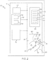
- system 11 for displaying regions on a coverage map 30 that are non-compliant 34 for a GNSS navigation system 40 in an aircraft is shown herein.
- system 11 includes many of the same components from system 10 from Figure 1 , the same reference numbers will be used and referenced when appropriate. Accordingly, the discussion of system 11 will relate to the features that differ relative in system 10.
- the system 11 is generally implemented in an aircraft 13.
- the aircraft 13 from system 11 includes the GNSS navigation system 40, the route compliance module 50, the navigation system database 60, the FMS 70, the display 80, and the communications bus 90.
- the route compliance module 50 from the system 11 is configured to adjust the visual display to differentiate the compliant region 32 and the non-compliant region 34 on the coverage map. Stated differently, while the route compliance module 50 is configured to identify a compliant region 32 of the coverage map 30 that is compliant with the geodetic reference datum standard and identify a non-compliant region 34 of the coverage map 30 that is not compliant with the geodetic reference datum standard based on the compliance information 62 and the route 20, the display of the route 20 does not change.
- the route compliance module 50 is configured to disable the LPV approach when the aircraft 13 is in the non-compliant region 34. In a non-limiting embodiment, the route compliance module 50 is configured to disable the LPV approach when a non-compliant airport is selected as a destination airport.
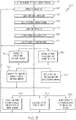
- FIG. 3 a flowchart illustrates a method 100 performed by the systems 10, 11 of Figures 1-2 in accordance with the present disclosure.
- the order of operation within the method 100 is not limited to the sequential execution as illustrated in Figure 3 , but may be performed in one or more varying orders as applicable and in accordance with the requirements of a given application.
- the systems 10, 11 method 100 are operated based on predetermined events, such as attempting to start up the aircraft 12, 13.
- Method 100 may be performed by the systems 10, 11 or may be performed by any other suitable device or system configured in a manner consistent with the teachings of the present disclosure. Unless otherwise noted, the method 100 may be performed by any of the embodiments of the systems 10, 11 previously described above.
- the method 100 starts at block 110 defining a geodetic reference datum standard based on the GNSS navigation system.
- the route compliance module 50 defines the geodetic reference datum standard based on the GNSS navigation system 40.
- the method 100 displays the coverage map on a visual display.
- the visual display 80 displays the coverage map 30.
- the method 100 queries a navigation system database to identify a compliant region of the coverage map that is compliant with the geodetic reference datum standard.
- the route compliance module 50 queries the navigation system database 60 to identify the compliant region 32 of the coverage map 30 that is compliant with the geodetic reference datum standard.
- the method 100 queries the navigation system database to identify a non-compliant region of the coverage map that is not compliant with the geodetic reference datum standard.
- the route compliance module 50 queries the navigation system database 60 to identify the non-compliant region 34 of the coverage map 30 that is not compliant with the geodetic reference datum standard.
- the method 100 queries a flight management system for a route of the aircraft.
- the route compliance module 50 queries the FMS 70 for the route 20 of the aircraft 12, 13.
- the method 100 displays the route on the coverage map.
- the visual display 80 displays the route 20 on the coverage map 30.
- the method 100 adjusts the visual display to differentiate a compliant portion of the route and a non-compliant portion of the route.
- the route compliance module 50 adjusts the visual display 80 to differentiate a compliant portion 22 of the route 20 and a non-compliant portion 24 of the route 20.
- the method 100 returns to block 120 and displays the coverage map. In this way, the method 100 displays portions of a route on a coverage map that are non-compliant for a GNSS navigation system in an aircraft.
- the method 100 further disables an LPV approach (block 180) when the aircraft is in the non-compliant region.
- the route compliance module 50 disables the LPV approach when the aircraft 12, 13, is in the non-compliant region 34.
- the method 100 further disables an LPV approach (block 190) when a non-compliant airport is selected as a destination airport.
- the route compliance module 50 disables the LPV approach when a non-compliant airport is selected as a destination airport.
- the method 100 further displays an LPV approach (block 200) that is not available for non-compliant airports.
- the visual display 80 displays that the LPV approach for the aircraft 12, 13, is not available for non-compliant airports.
- the method 100 further displays on an airport information screen (block 210) that a selected airport is a non-compliant airport.
- the visual display 80 displays on an airport information screen that the selected airport is a non-compliant airport.
- the method 100 further adjusts the visual display (block 220) to differentiate when the compliant portion of the route or the non-compliant portion of the route is outside a field of view of the coverage map.
- the route compliance module 50 adjusts the visual display 80 to differentiate when the compliant portion 22 of the route or the non-compliant portion 24 of the route 20 is outside a field of view of the coverage map 30.
- the method 100 further adjusts the visual display (block 230) prior to a takeoff of the aircraft.
- the route compliance module 50 adjusts the visual display 80 prior to a takeoff of the aircraft 12, 13.
- the method 100 further displays (block 24) the compliant portion of the route and the non-compliant portion of the route during a planning phase of the route.
- the visual display 80 displays the compliant portion 22 of the route 20 and the non-compliant portion 24 of the route 20 during a planning phase of the route 20.
Landscapes
- Engineering & Computer Science (AREA)
- Aviation & Aerospace Engineering (AREA)
- Physics & Mathematics (AREA)
- General Physics & Mathematics (AREA)
- Radar, Positioning & Navigation (AREA)
- Remote Sensing (AREA)
- Automation & Control Theory (AREA)
- Computer Networks & Wireless Communication (AREA)
- Navigation (AREA)
- Traffic Control Systems (AREA)
Claims (10)
- System zum Anzeigen von Abschnitten einer Route auf einer Abdeckungsbereichskarte, die nicht mit einem GNSS-Navigationssystem (globales Navigationssatellitensystem) in einem Flugzeug konform sind, wobei das System umfasst:ein Routenkonformitätsmodul, das dafür ausgelegt ist, einen Standard für geodätische Referenzdaten basierend auf dem GNSS-Navigationssystem zu definieren;eine Navigationssystem-Datenbank mit Konformitätsinformationen entsprechend jedem von mehreren Flughäfen;ein Flugmanagementsystem, das dafür ausgelegt ist, die Route des Flugzeugs zu bestimmen; undeine visuelle Anzeige, die dafür ausgelegt ist, die Route und die Abdeckungsbereichskarte anzuzeigen,wobei das Routenkonformitätsmodul ferner dafür ausgelegt ist, die Navigationssystem-Datenbank abzufragen, einen nicht konformen Bereich der Abdeckungsbereichskarte, der nicht mit dem Standard für geodätische Referenzdaten übereinstimmt, basierend auf den Konformitätsinformationen zu identifizieren und die visuelle Anzeige derart anzupassen, dass sie einen nicht konformen Abschnitt der Route, der sich innerhalb des nicht konformen Bereichs der Abdeckungsbereichskarte erstreckt, zu unterscheiden.
- System nach Anspruch 1, wobei das Routenkonformitätsmodul ferner ausgelegt ist zum:
Deaktivieren eines Anflugs mithilfe eines Landekursgebers mit Höhenführung (Localizer Performance With Vertical Guidance, LPV), wenn sich das Flugzeug im nicht konformen Bereich befindet. - System nach Anspruch 1, wobei das Routenkonformitätsmodul ferner ausgelegt ist zum:
Deaktivieren des Anflugs mithilfe eines Landekursgebers mit Höhenführung (LPV), wenn ein nicht konformer Flughafen als Zielflughafen der Route ausgewählt ist. - System nach Anspruch 1, wobei das Routenkonformitätsmodul ferner ausgelegt ist zum:
Anzeigen, dass ein Anflug mithilfe eines Landekursgebers mit Höhenführung (LPV) für den nicht konformen Flughafen nicht zur Verfügung steht. - System nach Anspruch 1, ferner einen Flughafeninformationsbildschirm umfassend, wobei das Routenkonformitätsmodul ferner dafür ausgelegt ist, auf dem Flughafeninformationsbildschirm anzuzeigen, dass ein ausgewählter Flughafen ein nicht konformer Flughafen ist.
- System nach Anspruch 1, wobei das Routenkonformitätsmodul ferner ausgelegt ist zum:
Anpassen der visuellen Anzeige derart, dass sie zwischen einem konformen und einem nicht konformen Flughafen unterscheidet. - System nach Anspruch 1, wobei das Routenkonformitätsmodul ferner ausgelegt ist zum:
Anpassen der visuellen Anzeige derart, dass sie unterscheidet, wenn der nicht konforme Abschnitt der Route außerhalb des Gesichtsfeldes der Abdeckungsbereichskarte liegt. - System nach Anspruch 1, wobei das Routenkonformitätsmodul ferner ausgelegt ist zum:
Anpassen der visuellen Anzeige vor einem Start des Flugzeugs. - System nach Anspruch 1, wobei das Routenkonformitätsmodul ferner ausgelegt ist zum:
Anzeigen des nicht konformen Abschnitts der Route während einer Routenplanungsphase. - Verfahren zum Anzeigen von Abschnitten einer Route auf einer Abdeckungsbereichskarte, die nicht mit einem GNSS-Navigationssystem (globale Navigationssatellitensystem) in einem Flugzeug konform sind, wobei das Verfahren umfasst:Definieren eines Standards für geodätische Referenzdaten basierend auf dem GNSS-Navigationssystem;Anzeigen der Abdeckungsbereichskarte auf einer visuellen Anzeige;Abfragen einer Navigationssystem-Datenbank mit Konformitätsinformationen entsprechend jedem von mehreren Flughäfen, um einen nicht konformen Bereich der Abdeckungsbereichskarte, der nicht mit dem Standard für geodätische Referenzdaten übereinstimmt, zu identifizieren;Abfragen eines Flugmanagementsystems für eine Route des Flugzeugs;Anzeige der Route auf der Abdeckungsbereichskarte; undAnpassen der visuellen Anzeige, um einen nicht konformen Abschnitt der Route, der sich innerhalb des nicht konformen Bereichs der Abdeckungsbereichskarte erstreckt, zu unterscheiden.
Applications Claiming Priority (1)
| Application Number | Priority Date | Filing Date | Title |
|---|---|---|---|
| US15/370,029 US10176721B2 (en) | 2016-12-06 | 2016-12-06 | System and method to depict geodetic reference datum non-compliance regions, airports, and flight planning elements on avionics based displays |
Publications (2)
| Publication Number | Publication Date |
|---|---|
| EP3333545A1 EP3333545A1 (de) | 2018-06-13 |
| EP3333545B1 true EP3333545B1 (de) | 2019-03-06 |
Family
ID=60484240
Family Applications (1)
| Application Number | Title | Priority Date | Filing Date |
|---|---|---|---|
| EP17204234.3A Not-in-force EP3333545B1 (de) | 2016-12-06 | 2017-11-28 | System und verfahren zur abbildung von geodätischen referenzdatenabweichungen von regionen, flughäfen und flugplanungselementen auf avionikbasierten anzeigen |
Country Status (3)
| Country | Link |
|---|---|
| US (1) | US10176721B2 (de) |
| EP (1) | EP3333545B1 (de) |
| CN (1) | CN108152834B (de) |
Families Citing this family (1)
| Publication number | Priority date | Publication date | Assignee | Title |
|---|---|---|---|---|
| US10909865B2 (en) * | 2019-02-06 | 2021-02-02 | Honeywell International Inc. | System and method to identify, depict and alert distress and special traffic based on at least squawk codes |
Family Cites Families (34)
| Publication number | Priority date | Publication date | Assignee | Title |
|---|---|---|---|---|
| US6195609B1 (en) * | 1993-09-07 | 2001-02-27 | Harold Robert Pilley | Method and system for the control and management of an airport |
| US5216611A (en) * | 1991-02-08 | 1993-06-01 | Rockwell International Corporation | Integrated enroute and approach guidance system for aircraft |
| US5361212A (en) * | 1992-11-02 | 1994-11-01 | Honeywell Inc. | Differential GPS landing assistance system |
| DE60011996T2 (de) * | 1999-02-01 | 2005-07-21 | Honeywell International Inc. | Vorrichtung, verfahren und computerprogramm zur erzeugung einer geländehindernis-bodenhüllkurve für eine ausgewährte landebahn |
| US6480789B2 (en) * | 2000-12-04 | 2002-11-12 | American Gnc Corporation | Positioning and proximity warning method and system thereof for vehicle |
| US6528855B2 (en) | 2001-07-24 | 2003-03-04 | Infineon Technologies Ag | MOSFET having a low aspect ratio between the gate and the source/drain |
| US6675095B1 (en) * | 2001-12-15 | 2004-01-06 | Trimble Navigation, Ltd | On-board apparatus for avoiding restricted air space in non-overriding mode |
| US7373223B2 (en) * | 2004-02-13 | 2008-05-13 | The Boeing Company | Global navigation satellite system landing systems and methods |
| US7650232B1 (en) * | 2005-09-22 | 2010-01-19 | The United States Of America As Represented By The Administrator Of The National Aeronautics And Space Administration (Nasa) | Trajectory specification for high capacity air traffic control |
| US7693621B1 (en) * | 2006-06-27 | 2010-04-06 | Toyota Motor Sales, U.S.A., Inc. | Apparatus and methods for displaying arrival, approach, and departure information on a display device in an aircraft |
| US8165087B2 (en) | 2007-06-30 | 2012-04-24 | Microsoft Corporation | Location context service handoff |
| US8094154B1 (en) * | 2007-12-20 | 2012-01-10 | The United States Of America As Represented By The Secretary Of The Navy | Intelligent leading indicator display |
| US8035547B1 (en) * | 2008-03-17 | 2011-10-11 | Garmin Switzerland Gmbh | System and method of assisted aerial navigation |
| US8620306B2 (en) * | 2008-06-24 | 2013-12-31 | Qualcomm Incorporated | Location specific search for regional satellite vehicles |
| US8718915B1 (en) * | 2008-09-08 | 2014-05-06 | Rockwell Collins, Inc. | System, module, and method for generating an image of a flight route corridor on a display unit |
| US8234058B1 (en) * | 2008-09-08 | 2012-07-31 | Rockwell Collins, Inc. | System, module, and method for generating procedure data used in an avionics system |
| US9746336B2 (en) * | 2010-09-13 | 2017-08-29 | Tomtom Navigation B.V. | Navigation device and method |
| WO2012057256A1 (ja) | 2010-10-28 | 2012-05-03 | 株式会社ゼンリンデータコム | ナビゲーション端末、ナビゲーション方法およびナビゲーションプログラム |
| FR2980618A1 (fr) * | 2011-09-22 | 2013-03-29 | Airbus Operations Sas | Procede et systeme de determination d'une information de position d'un aeronef lors d'une approche d'une piste d'atterrissage. |
| US20130300587A1 (en) * | 2012-05-14 | 2013-11-14 | Honeywell International Inc. | System and method for displaying runway approach texture objects |
| US20130345905A1 (en) * | 2012-06-25 | 2013-12-26 | Honeywell International Inc. | Avionics display system providing enhanced flight-plan management |
| US9168859B2 (en) * | 2013-02-25 | 2015-10-27 | Honeywell International Inc. | System and method for displaying visual flight reference points |
| US9377325B2 (en) * | 2013-03-18 | 2016-06-28 | Honeywell International Inc. | System and method for graphically displaying airspace speed data |
| FR3004250B1 (fr) * | 2013-04-03 | 2015-03-27 | Thales Sa | Procede de determination d'un chemin de roulage d'un aeronef sur une zone aeroportuaire. |
| US20160086497A1 (en) * | 2013-04-16 | 2016-03-24 | Bae Systems Australia Limited | Landing site tracker |
| US9098999B2 (en) * | 2013-09-13 | 2015-08-04 | The Boeing Company | Systems and methods for assuring the accuracy of a synthetic runway presentation |
| CN103714719B (zh) * | 2014-01-16 | 2016-02-10 | 天津天航创力科技有限公司 | 基于北斗卫星导航的通航飞行导航系统 |
| US9193442B1 (en) * | 2014-05-21 | 2015-11-24 | Rockwell Collins, Inc. | Predictable and required time of arrival compliant optimized profile descents with four dimensional flight management system and related method |
| US9335917B2 (en) * | 2014-06-09 | 2016-05-10 | Honeywell International Inc. | System and method for providing enhanced HMI navigation |
| US9746562B2 (en) * | 2014-06-30 | 2017-08-29 | The Boeing Company | Portable ground based augmentation system |
| US9593961B2 (en) * | 2014-08-13 | 2017-03-14 | Honeywell International Inc. | System and method for integrated time based notification for improved situational awareness |
| US9495879B2 (en) * | 2014-12-10 | 2016-11-15 | Airbus Operations Sas | Systems and methods for providing optimized taxiing path operation for an aircraft |
| US9672747B2 (en) * | 2015-06-15 | 2017-06-06 | WxOps, Inc. | Common operating environment for aircraft operations |
| US9818305B2 (en) * | 2015-09-18 | 2017-11-14 | The Boeing Company | Method and apparatus for monitoring compliance with a non-transgression zone between aircraft approach corridors |
-
2016
- 2016-12-06 US US15/370,029 patent/US10176721B2/en active Active
-
2017
- 2017-10-26 CN CN201711012643.8A patent/CN108152834B/zh active Active
- 2017-11-28 EP EP17204234.3A patent/EP3333545B1/de not_active Not-in-force
Non-Patent Citations (1)
| Title |
|---|
| None * |
Also Published As
| Publication number | Publication date |
|---|---|
| EP3333545A1 (de) | 2018-06-13 |
| US10176721B2 (en) | 2019-01-08 |
| CN108152834B (zh) | 2022-12-06 |
| CN108152834A (zh) | 2018-06-12 |
| US20180158343A1 (en) | 2018-06-07 |
Similar Documents
| Publication | Publication Date | Title |
|---|---|---|
| US9335917B2 (en) | System and method for providing enhanced HMI navigation | |
| US11270593B2 (en) | Advisory method and system for flight trajectory optimization | |
| EP2763124B1 (de) | Verfahren und Vorrichtung zur Erzeugung eines virtuellen inneren Markers für einen Flugzeuglandeanflug | |
| US9851219B2 (en) | Methods and systems for route-based scrolling of a navigational map | |
| US9046369B2 (en) | Methods and systems for updating a map in response to selection of content for display on the map | |
| US9470528B1 (en) | Aircraft synthetic vision systems utilizing data from local area augmentation systems, and methods for operating such aircraft synthetic vision systems | |
| US9260199B2 (en) | Aircraft data processing and transmission system | |
| EP3933807A1 (de) | Cockpit-anzeigesysteme und verfahren zur anzeige der rollroute auf einer flughafenbewegungskarte | |
| US9377325B2 (en) | System and method for graphically displaying airspace speed data | |
| EP2980772B1 (de) | System und verfahren zur automatischen identifizierung von angezeigtem, von der flugsicherung erwähntem verkehr | |
| CN111311966A (zh) | 用于对飞行器任务提醒进行提示的方法和系统 | |
| US10290217B1 (en) | Systems and methods for evaluation of runway changes | |
| CN105608932A (zh) | 用于显示跑道进场信息的系统和方法 | |
| EP3611473A1 (de) | Systeme und verfahren zur auswahl von genauen landebahnaufzeichnungen für den einsatz in cockpitanzeigesystemen | |
| US9168859B2 (en) | System and method for displaying visual flight reference points | |
| US20220388674A1 (en) | Methods and systems for alerting dynamic changes in flight rules | |
| US10176721B2 (en) | System and method to depict geodetic reference datum non-compliance regions, airports, and flight planning elements on avionics based displays | |
| US20160041001A1 (en) | System and method for enhancing altitude situational awareness on a vertical situation display | |
| EP4099301B1 (de) | Verfahren und systeme zum warnen vor dynamischen änderungen in flugregeln | |
| US12609036B2 (en) | Methods and systems for providing conditional estimated arrival times | |
| EP4531021A1 (de) | Verfahren und systeme zur bereitstellung bedingter geschätzter ankunftszeiten | |
| EP4242593A1 (de) | Auf kommunikationsverwaltungseinheit (cmu) basierende unterstützung für automatische erfüllung von abhängigem überwachungskontrakt (ads-c) | |
| EP2911121A1 (de) | Flugzeugdatenverarbeitung und Übertragungssystem |
Legal Events
| Date | Code | Title | Description |
|---|---|---|---|
| PUAI | Public reference made under article 153(3) epc to a published international application that has entered the european phase |
Free format text: ORIGINAL CODE: 0009012 |
|
| STAA | Information on the status of an ep patent application or granted ep patent |
Free format text: STATUS: REQUEST FOR EXAMINATION WAS MADE |
|
| 17P | Request for examination filed |
Effective date: 20171128 |
|
| AK | Designated contracting states |
Kind code of ref document: A1 Designated state(s): AL AT BE BG CH CY CZ DE DK EE ES FI FR GB GR HR HU IE IS IT LI LT LU LV MC MK MT NL NO PL PT RO RS SE SI SK SM TR |
|
| AX | Request for extension of the european patent |
Extension state: BA ME |
|
| GRAP | Despatch of communication of intention to grant a patent |
Free format text: ORIGINAL CODE: EPIDOSNIGR1 |
|
| STAA | Information on the status of an ep patent application or granted ep patent |
Free format text: STATUS: GRANT OF PATENT IS INTENDED |
|
| INTG | Intention to grant announced |
Effective date: 20181016 |
|
| GRAS | Grant fee paid |
Free format text: ORIGINAL CODE: EPIDOSNIGR3 |
|
| GRAA | (expected) grant |
Free format text: ORIGINAL CODE: 0009210 |
|
| STAA | Information on the status of an ep patent application or granted ep patent |
Free format text: STATUS: THE PATENT HAS BEEN GRANTED |
|
| AK | Designated contracting states |
Kind code of ref document: B1 Designated state(s): AL AT BE BG CH CY CZ DE DK EE ES FI FR GB GR HR HU IE IS IT LI LT LU LV MC MK MT NL NO PL PT RO RS SE SI SK SM TR |
|
| REG | Reference to a national code |
Ref country code: GB Ref legal event code: FG4D |
|
| REG | Reference to a national code |
Ref country code: CH Ref legal event code: EP Ref country code: AT Ref legal event code: REF Ref document number: 1105162 Country of ref document: AT Kind code of ref document: T Effective date: 20190315 |
|
| REG | Reference to a national code |
Ref country code: DE Ref legal event code: R096 Ref document number: 602017002532 Country of ref document: DE |
|
| REG | Reference to a national code |
Ref country code: IE Ref legal event code: FG4D |
|
| REG | Reference to a national code |
Ref country code: NL Ref legal event code: MP Effective date: 20190306 |
|
| REG | Reference to a national code |
Ref country code: LT Ref legal event code: MG4D |
|
| PG25 | Lapsed in a contracting state [announced via postgrant information from national office to epo] |
Ref country code: LT Free format text: LAPSE BECAUSE OF FAILURE TO SUBMIT A TRANSLATION OF THE DESCRIPTION OR TO PAY THE FEE WITHIN THE PRESCRIBED TIME-LIMIT Effective date: 20190306 Ref country code: SE Free format text: LAPSE BECAUSE OF FAILURE TO SUBMIT A TRANSLATION OF THE DESCRIPTION OR TO PAY THE FEE WITHIN THE PRESCRIBED TIME-LIMIT Effective date: 20190306 Ref country code: NO Free format text: LAPSE BECAUSE OF FAILURE TO SUBMIT A TRANSLATION OF THE DESCRIPTION OR TO PAY THE FEE WITHIN THE PRESCRIBED TIME-LIMIT Effective date: 20190606 Ref country code: FI Free format text: LAPSE BECAUSE OF FAILURE TO SUBMIT A TRANSLATION OF THE DESCRIPTION OR TO PAY THE FEE WITHIN THE PRESCRIBED TIME-LIMIT Effective date: 20190306 |
|
| PG25 | Lapsed in a contracting state [announced via postgrant information from national office to epo] |
Ref country code: LV Free format text: LAPSE BECAUSE OF FAILURE TO SUBMIT A TRANSLATION OF THE DESCRIPTION OR TO PAY THE FEE WITHIN THE PRESCRIBED TIME-LIMIT Effective date: 20190306 Ref country code: NL Free format text: LAPSE BECAUSE OF FAILURE TO SUBMIT A TRANSLATION OF THE DESCRIPTION OR TO PAY THE FEE WITHIN THE PRESCRIBED TIME-LIMIT Effective date: 20190306 Ref country code: RS Free format text: LAPSE BECAUSE OF FAILURE TO SUBMIT A TRANSLATION OF THE DESCRIPTION OR TO PAY THE FEE WITHIN THE PRESCRIBED TIME-LIMIT Effective date: 20190306 Ref country code: BG Free format text: LAPSE BECAUSE OF FAILURE TO SUBMIT A TRANSLATION OF THE DESCRIPTION OR TO PAY THE FEE WITHIN THE PRESCRIBED TIME-LIMIT Effective date: 20190606 Ref country code: HR Free format text: LAPSE BECAUSE OF FAILURE TO SUBMIT A TRANSLATION OF THE DESCRIPTION OR TO PAY THE FEE WITHIN THE PRESCRIBED TIME-LIMIT Effective date: 20190306 Ref country code: GR Free format text: LAPSE BECAUSE OF FAILURE TO SUBMIT A TRANSLATION OF THE DESCRIPTION OR TO PAY THE FEE WITHIN THE PRESCRIBED TIME-LIMIT Effective date: 20190607 |
|
| REG | Reference to a national code |
Ref country code: AT Ref legal event code: MK05 Ref document number: 1105162 Country of ref document: AT Kind code of ref document: T Effective date: 20190306 |
|
| PG25 | Lapsed in a contracting state [announced via postgrant information from national office to epo] |
Ref country code: PT Free format text: LAPSE BECAUSE OF FAILURE TO SUBMIT A TRANSLATION OF THE DESCRIPTION OR TO PAY THE FEE WITHIN THE PRESCRIBED TIME-LIMIT Effective date: 20190706 Ref country code: ES Free format text: LAPSE BECAUSE OF FAILURE TO SUBMIT A TRANSLATION OF THE DESCRIPTION OR TO PAY THE FEE WITHIN THE PRESCRIBED TIME-LIMIT Effective date: 20190306 Ref country code: AL Free format text: LAPSE BECAUSE OF FAILURE TO SUBMIT A TRANSLATION OF THE DESCRIPTION OR TO PAY THE FEE WITHIN THE PRESCRIBED TIME-LIMIT Effective date: 20190306 Ref country code: CZ Free format text: LAPSE BECAUSE OF FAILURE TO SUBMIT A TRANSLATION OF THE DESCRIPTION OR TO PAY THE FEE WITHIN THE PRESCRIBED TIME-LIMIT Effective date: 20190306 Ref country code: IT Free format text: LAPSE BECAUSE OF FAILURE TO SUBMIT A TRANSLATION OF THE DESCRIPTION OR TO PAY THE FEE WITHIN THE PRESCRIBED TIME-LIMIT Effective date: 20190306 Ref country code: EE Free format text: LAPSE BECAUSE OF FAILURE TO SUBMIT A TRANSLATION OF THE DESCRIPTION OR TO PAY THE FEE WITHIN THE PRESCRIBED TIME-LIMIT Effective date: 20190306 Ref country code: SK Free format text: LAPSE BECAUSE OF FAILURE TO SUBMIT A TRANSLATION OF THE DESCRIPTION OR TO PAY THE FEE WITHIN THE PRESCRIBED TIME-LIMIT Effective date: 20190306 Ref country code: RO Free format text: LAPSE BECAUSE OF FAILURE TO SUBMIT A TRANSLATION OF THE DESCRIPTION OR TO PAY THE FEE WITHIN THE PRESCRIBED TIME-LIMIT Effective date: 20190306 |
|
| PG25 | Lapsed in a contracting state [announced via postgrant information from national office to epo] |
Ref country code: PL Free format text: LAPSE BECAUSE OF FAILURE TO SUBMIT A TRANSLATION OF THE DESCRIPTION OR TO PAY THE FEE WITHIN THE PRESCRIBED TIME-LIMIT Effective date: 20190306 Ref country code: SM Free format text: LAPSE BECAUSE OF FAILURE TO SUBMIT A TRANSLATION OF THE DESCRIPTION OR TO PAY THE FEE WITHIN THE PRESCRIBED TIME-LIMIT Effective date: 20190306 |
|
| REG | Reference to a national code |
Ref country code: DE Ref legal event code: R097 Ref document number: 602017002532 Country of ref document: DE |
|
| PG25 | Lapsed in a contracting state [announced via postgrant information from national office to epo] |
Ref country code: AT Free format text: LAPSE BECAUSE OF FAILURE TO SUBMIT A TRANSLATION OF THE DESCRIPTION OR TO PAY THE FEE WITHIN THE PRESCRIBED TIME-LIMIT Effective date: 20190306 Ref country code: IS Free format text: LAPSE BECAUSE OF FAILURE TO SUBMIT A TRANSLATION OF THE DESCRIPTION OR TO PAY THE FEE WITHIN THE PRESCRIBED TIME-LIMIT Effective date: 20190706 |
|
| PLBE | No opposition filed within time limit |
Free format text: ORIGINAL CODE: 0009261 |
|
| STAA | Information on the status of an ep patent application or granted ep patent |
Free format text: STATUS: NO OPPOSITION FILED WITHIN TIME LIMIT |
|
| PG25 | Lapsed in a contracting state [announced via postgrant information from national office to epo] |
Ref country code: DK Free format text: LAPSE BECAUSE OF FAILURE TO SUBMIT A TRANSLATION OF THE DESCRIPTION OR TO PAY THE FEE WITHIN THE PRESCRIBED TIME-LIMIT Effective date: 20190306 |
|
| 26N | No opposition filed |
Effective date: 20191209 |
|
| PG25 | Lapsed in a contracting state [announced via postgrant information from national office to epo] |
Ref country code: TR Free format text: LAPSE BECAUSE OF FAILURE TO SUBMIT A TRANSLATION OF THE DESCRIPTION OR TO PAY THE FEE WITHIN THE PRESCRIBED TIME-LIMIT Effective date: 20190306 |
|
| PG25 | Lapsed in a contracting state [announced via postgrant information from national office to epo] |
Ref country code: LU Free format text: LAPSE BECAUSE OF NON-PAYMENT OF DUE FEES Effective date: 20191128 Ref country code: MC Free format text: LAPSE BECAUSE OF FAILURE TO SUBMIT A TRANSLATION OF THE DESCRIPTION OR TO PAY THE FEE WITHIN THE PRESCRIBED TIME-LIMIT Effective date: 20190306 |
|
| REG | Reference to a national code |
Ref country code: BE Ref legal event code: MM Effective date: 20191130 |
|
| PG25 | Lapsed in a contracting state [announced via postgrant information from national office to epo] |
Ref country code: IE Free format text: LAPSE BECAUSE OF NON-PAYMENT OF DUE FEES Effective date: 20191128 |
|
| PG25 | Lapsed in a contracting state [announced via postgrant information from national office to epo] |
Ref country code: BE Free format text: LAPSE BECAUSE OF NON-PAYMENT OF DUE FEES Effective date: 20191130 |
|
| PG25 | Lapsed in a contracting state [announced via postgrant information from national office to epo] |
Ref country code: CY Free format text: LAPSE BECAUSE OF FAILURE TO SUBMIT A TRANSLATION OF THE DESCRIPTION OR TO PAY THE FEE WITHIN THE PRESCRIBED TIME-LIMIT Effective date: 20190306 |
|
| REG | Reference to a national code |
Ref country code: CH Ref legal event code: PL |
|
| PG25 | Lapsed in a contracting state [announced via postgrant information from national office to epo] |
Ref country code: HU Free format text: LAPSE BECAUSE OF FAILURE TO SUBMIT A TRANSLATION OF THE DESCRIPTION OR TO PAY THE FEE WITHIN THE PRESCRIBED TIME-LIMIT; INVALID AB INITIO Effective date: 20171128 Ref country code: MT Free format text: LAPSE BECAUSE OF FAILURE TO SUBMIT A TRANSLATION OF THE DESCRIPTION OR TO PAY THE FEE WITHIN THE PRESCRIBED TIME-LIMIT Effective date: 20190306 |
|
| PG25 | Lapsed in a contracting state [announced via postgrant information from national office to epo] |
Ref country code: LI Free format text: LAPSE BECAUSE OF NON-PAYMENT OF DUE FEES Effective date: 20201130 Ref country code: CH Free format text: LAPSE BECAUSE OF NON-PAYMENT OF DUE FEES Effective date: 20201130 |
|
| PG25 | Lapsed in a contracting state [announced via postgrant information from national office to epo] |
Ref country code: SI Free format text: LAPSE BECAUSE OF FAILURE TO SUBMIT A TRANSLATION OF THE DESCRIPTION OR TO PAY THE FEE WITHIN THE PRESCRIBED TIME-LIMIT Effective date: 20190306 |
|
| PGFP | Annual fee paid to national office [announced via postgrant information from national office to epo] |
Ref country code: GB Payment date: 20220222 Year of fee payment: 5 Ref country code: DE Payment date: 20220225 Year of fee payment: 5 |
|
| PGFP | Annual fee paid to national office [announced via postgrant information from national office to epo] |
Ref country code: FR Payment date: 20220224 Year of fee payment: 5 |
|
| PG25 | Lapsed in a contracting state [announced via postgrant information from national office to epo] |
Ref country code: MK Free format text: LAPSE BECAUSE OF FAILURE TO SUBMIT A TRANSLATION OF THE DESCRIPTION OR TO PAY THE FEE WITHIN THE PRESCRIBED TIME-LIMIT Effective date: 20190306 |
|
| REG | Reference to a national code |
Ref country code: DE Ref legal event code: R119 Ref document number: 602017002532 Country of ref document: DE |
|
| P01 | Opt-out of the competence of the unified patent court (upc) registered |
Effective date: 20230525 |
|
| GBPC | Gb: european patent ceased through non-payment of renewal fee |
Effective date: 20221128 |
|
| PG25 | Lapsed in a contracting state [announced via postgrant information from national office to epo] |
Ref country code: GB Free format text: LAPSE BECAUSE OF NON-PAYMENT OF DUE FEES Effective date: 20221128 Ref country code: DE Free format text: LAPSE BECAUSE OF NON-PAYMENT OF DUE FEES Effective date: 20230601 |
|
| PG25 | Lapsed in a contracting state [announced via postgrant information from national office to epo] |
Ref country code: FR Free format text: LAPSE BECAUSE OF NON-PAYMENT OF DUE FEES Effective date: 20221130 |