EP3156767A2 - Method and device for navigating and method and device for generating a navigation video - Google Patents
Method and device for navigating and method and device for generating a navigation video Download PDFInfo
- Publication number
- EP3156767A2 EP3156767A2 EP16188955.5A EP16188955A EP3156767A2 EP 3156767 A2 EP3156767 A2 EP 3156767A2 EP 16188955 A EP16188955 A EP 16188955A EP 3156767 A2 EP3156767 A2 EP 3156767A2
- Authority
- EP
- European Patent Office
- Prior art keywords
- navigation
- video
- module
- matching
- request information
- Prior art date
- Legal status (The legal status is an assumption and is not a legal conclusion. Google has not performed a legal analysis and makes no representation as to the accuracy of the status listed.)
- Granted
Links
- 238000000034 method Methods 0.000 title claims abstract description 73
- 238000010586 diagram Methods 0.000 description 42
- 238000004891 communication Methods 0.000 description 11
- 230000000694 effects Effects 0.000 description 6
- 238000005516 engineering process Methods 0.000 description 6
- 230000035484 reaction time Effects 0.000 description 5
- 230000003287 optical effect Effects 0.000 description 4
- 230000005236 sound signal Effects 0.000 description 4
- 230000006870 function Effects 0.000 description 3
- 238000007726 management method Methods 0.000 description 3
- 230000009471 action Effects 0.000 description 2
- 230000008859 change Effects 0.000 description 2
- 238000001914 filtration Methods 0.000 description 2
- 230000003993 interaction Effects 0.000 description 2
- 230000000737 periodic effect Effects 0.000 description 2
- 230000002093 peripheral effect Effects 0.000 description 2
- 101150104012 TOP2 gene Proteins 0.000 description 1
- 230000001133 acceleration Effects 0.000 description 1
- 230000006978 adaptation Effects 0.000 description 1
- 238000003491 array Methods 0.000 description 1
- 230000009286 beneficial effect Effects 0.000 description 1
- 238000010276 construction Methods 0.000 description 1
- 238000013500 data storage Methods 0.000 description 1
- 238000003384 imaging method Methods 0.000 description 1
- 239000004973 liquid crystal related substance Substances 0.000 description 1
- 238000012986 modification Methods 0.000 description 1
- 230000004048 modification Effects 0.000 description 1
- 230000003068 static effect Effects 0.000 description 1
Images


Classifications
-
- G—PHYSICS
- G01—MEASURING; TESTING
- G01C—MEASURING DISTANCES, LEVELS OR BEARINGS; SURVEYING; NAVIGATION; GYROSCOPIC INSTRUMENTS; PHOTOGRAMMETRY OR VIDEOGRAMMETRY
- G01C21/00—Navigation; Navigational instruments not provided for in groups G01C1/00 - G01C19/00
- G01C21/26—Navigation; Navigational instruments not provided for in groups G01C1/00 - G01C19/00 specially adapted for navigation in a road network
- G01C21/34—Route searching; Route guidance
- G01C21/36—Input/output arrangements for on-board computers
- G01C21/3626—Details of the output of route guidance instructions
- G01C21/3647—Guidance involving output of stored or live camera images or video streams
-
- G—PHYSICS
- G01—MEASURING; TESTING
- G01C—MEASURING DISTANCES, LEVELS OR BEARINGS; SURVEYING; NAVIGATION; GYROSCOPIC INSTRUMENTS; PHOTOGRAMMETRY OR VIDEOGRAMMETRY
- G01C21/00—Navigation; Navigational instruments not provided for in groups G01C1/00 - G01C19/00
- G01C21/26—Navigation; Navigational instruments not provided for in groups G01C1/00 - G01C19/00 specially adapted for navigation in a road network
- G01C21/34—Route searching; Route guidance
- G01C21/3453—Special cost functions, i.e. other than distance or default speed limit of road segments
- G01C21/3492—Special cost functions, i.e. other than distance or default speed limit of road segments employing speed data or traffic data, e.g. real-time or historical
-
- G—PHYSICS
- G01—MEASURING; TESTING
- G01C—MEASURING DISTANCES, LEVELS OR BEARINGS; SURVEYING; NAVIGATION; GYROSCOPIC INSTRUMENTS; PHOTOGRAMMETRY OR VIDEOGRAMMETRY
- G01C21/00—Navigation; Navigational instruments not provided for in groups G01C1/00 - G01C19/00
- G01C21/26—Navigation; Navigational instruments not provided for in groups G01C1/00 - G01C19/00 specially adapted for navigation in a road network
- G01C21/34—Route searching; Route guidance
- G01C21/36—Input/output arrangements for on-board computers
- G01C21/3605—Destination input or retrieval
- G01C21/3623—Destination input or retrieval using a camera or code reader, e.g. for optical or magnetic codes
-
- G—PHYSICS
- G06—COMPUTING; CALCULATING OR COUNTING
- G06V—IMAGE OR VIDEO RECOGNITION OR UNDERSTANDING
- G06V20/00—Scenes; Scene-specific elements
- G06V20/40—Scenes; Scene-specific elements in video content
- G06V20/48—Matching video sequences
-
- G—PHYSICS
- G11—INFORMATION STORAGE
- G11B—INFORMATION STORAGE BASED ON RELATIVE MOVEMENT BETWEEN RECORD CARRIER AND TRANSDUCER
- G11B27/00—Editing; Indexing; Addressing; Timing or synchronising; Monitoring; Measuring tape travel
- G11B27/02—Editing, e.g. varying the order of information signals recorded on, or reproduced from, record carriers
- G11B27/031—Electronic editing of digitised analogue information signals, e.g. audio or video signals
-
- G—PHYSICS
- G11—INFORMATION STORAGE
- G11B—INFORMATION STORAGE BASED ON RELATIVE MOVEMENT BETWEEN RECORD CARRIER AND TRANSDUCER
- G11B27/00—Editing; Indexing; Addressing; Timing or synchronising; Monitoring; Measuring tape travel
- G11B27/10—Indexing; Addressing; Timing or synchronising; Measuring tape travel
- G11B27/102—Programmed access in sequence to addressed parts of tracks of operating record carriers
-
- G—PHYSICS
- G11—INFORMATION STORAGE
- G11B—INFORMATION STORAGE BASED ON RELATIVE MOVEMENT BETWEEN RECORD CARRIER AND TRANSDUCER
- G11B27/00—Editing; Indexing; Addressing; Timing or synchronising; Monitoring; Measuring tape travel
- G11B27/10—Indexing; Addressing; Timing or synchronising; Measuring tape travel
- G11B27/34—Indicating arrangements
-
- G—PHYSICS
- G01—MEASURING; TESTING
- G01C—MEASURING DISTANCES, LEVELS OR BEARINGS; SURVEYING; NAVIGATION; GYROSCOPIC INSTRUMENTS; PHOTOGRAMMETRY OR VIDEOGRAMMETRY
- G01C21/00—Navigation; Navigational instruments not provided for in groups G01C1/00 - G01C19/00
- G01C21/26—Navigation; Navigational instruments not provided for in groups G01C1/00 - G01C19/00 specially adapted for navigation in a road network
- G01C21/34—Route searching; Route guidance
- G01C21/36—Input/output arrangements for on-board computers
Definitions
- the present disclosure generally relates to the field of wireless communication technology, and more particularly to a method and device for navigating and a method and device for generating a navigation video.
- Embodiments of the present disclosure provide a method and device for navigation and generating a navigation video.
- the technical solutions are as follows.
- a method for navigating including: obtaining navigation request information; determining a navigation video matching with the navigation request information, wherein the navigation video is the video obtained from the location shooting of a road; navigating based on the navigation video.
- the navigation request information includes navigation parameters of a navigation starting point and a navigation ending point
- the processing of determining the navigation video matching with the navigation request information includes: obtaining the navigation starting point and navigation ending point of the navigation video; determining a navigation video, both the navigation starting point and the navigation ending point of which are the same as those of the navigation request information as the navigation video matching with the navigation starting point and the navigation ending point.
- the navigation request information includes navigation parameters of a navigation starting point and a navigation ending point
- the processing of determining the navigation video matching with the navigation request information includes: calculating a navigation route based on the navigation starting point and the navigation ending point; querying for a navigation video comprising the navigation route; cutting out a navigation video corresponding to the navigation route from the navigation video comprising the navigation route, and determining the navigation video corresponding to the navigation route as the navigation video matching with the navigation starting point and the navigation ending point.
- the navigation request information includes navigation parameters of a navigation starting point and a navigation ending point
- the processing of determining the navigation video matching with the navigation request information includes: calculating a navigation route based on the navigation starting point and the navigation ending point; dividing the navigation route into at least two navigation sub-routes; inquiring the navigation videos corresponding to the navigation sub-routes respectively; splicing the navigation videos corresponding to the navigation sub-routes to obtain the navigation video matching with the navigation starting point and the navigation ending point.
- the navigation request information further includes at least one of the following navigation parameters: a region name, a road name, a season, weather, an average driving speed, and a driving distance; in case that at least two navigation videos matching with the navigation starting point and the navigation ending point are obtained by querying, the processing of determining a navigation video matching with the navigation request information includes: obtaining the navigation parameters of the navigation videos; calculating matching degrees of the navigation parameters of the navigation request information with respect to the navigation parameters of the navigation videos; determining a navigation video whose matching degree is the largest as the navigation video matching with the navigation request information, or determining navigation videos whose matching degrees are larger than a preset threshold as navigation videos matching with the navigation request information, or determining a predetermined number of navigation videos whose matching degrees are relatively high as navigation videos matching with the navigation request information.
- navigating according to the navigation video when the method is applied to a network including: sending the navigation video to a terminal, for playing.
- navigating according to the navigation video when the method is applied to a terminal including: playing the navigation video.
- the processing of navigating based on the navigation video includes: arranging and displaying the navigation videos matching with the navigation request information; receiving an operation for selecting one of the navigation videos from a user; playing the navigation video.
- the processing of navigating based on the navigation video includes: obtaining a present driving speed; determining a playing speed of the navigation video based on the present driving speed; playing the navigation video at the playing speed.
- the method when the method is applied to terminal, including: synchronizing navigation data from the a network, wherein the navigation data include the navigation video; storing the navigation data in a local navigation database; the processing of determining the navigation video matching with the navigation request information includes: querying for the navigation video matching with the navigation request information from the local navigation database.
- a method for generating a navigation video including: obtaining navigation parameters entered by a user, wherein the navigation parameters comprise a navigation starting point and a navigation ending point; location shooting a road to obtain a shot video, wherein the shooting is stopped when the navigation ending point is reached; associating the navigation parameters with the shot video to obtain the navigation video; uploading the navigation video to a network.
- the method further includes: recording driving speed; calculating an average driving speed based on the driving speed; the processing of associating the navigation parameters with the shooting video includes: taking the average driving speed as a navigation parameter to associate it with the shot video.
- a device for navigating including: an obtaining module configured to obtain navigation request information; a determining module configured to determine a navigation video matching with the navigation request information, wherein the navigation video is a video obtained from location shooting of a road; a navigating module configured to navigate based on the navigation video.
- the navigation request information includes navigation parameters of a navigation starting point and a navigation ending point
- the determining module includes: a first obtaining sub-module configured to obtain navigation starting points and navigation ending points of navigation videos; a determining sub-module configured to determine a navigation video, both the navigation starting point and the navigation ending point of which are the same as those of the navigation request information as the navigation video matching with the navigation starting point and the navigation ending point.
- the navigation request information includes navigation parameters of a navigation starting point and a navigation ending point
- the determining module includes: a first computing sub-module configured to calculate a navigation route based on the navigation starting point and the navigation ending point; a querying sub-module configured to query for a navigation video comprising the navigation route; a cutting-out sub-module configured to cut out a navigation video corresponding to the navigation route from the navigation video comprising the navigation route, and determining the navigation video corresponding to the navigation route as the navigation video matching with the navigation starting point and the navigation ending point.
- the navigation request information includes navigation parameters of a navigation starting point and a navigation ending point
- the determining module includes: a first computing sub-module configured to calculate a navigation route based on the navigation starting point and the navigation ending point; a dividing sub-module configured to divide the navigation route into at least two navigation sub-routes; an inquiring sub-module configured to query for navigation videos corresponding to the navigation sub-routes respectively; a splicing sub-module configured to splice the navigation videos corresponding to the navigation sub-routes to obtain the navigation video matching with the navigation starting point and the navigation ending point.
- the navigation request information further comprises at least one of the following navigation parameters: a regional name, a road name, a season, weather, an average driving speed, and a driving distance; and the determining module includes: a second obtaining sub-module configured to, in case that at least two navigation videos matching with the navigation starting point and the navigation ending point are obtained by querying; configured to calculate matching degrees of the navigation parameters of the navigation request information with respect to the navigation parameters of the navigation videos; wherein the determining sub-module for determining a navigation video whose matching degree is the largest as the navigation video matching with the navigation request information, or determining navigation videos whose matching degrees are larger than a preset threshold as navigation videos matching with the navigation request information, or determining a predetermined number of navigation videos whose matching degrees are relatively high as navigation videos matching with the navigation request information.
- the navigating module is configured to send the navigation video to a terminal for playing when the device is applied to a network.
- the navigating module is configured to play the navigation video when the device is applied to a terminal.
- the navigating module includes: a displaying sub-module configured to, when at least two navigation videos matching with the navigation request information are determined, arrange and display the navigation videos matching with the navigation request information; a receiving sub-module configured to receive an operation for selecting one of the navigation videos from a user; a playing sub-module configured to play the selected navigation video.
- the navigation module includes: an obtaining sub-module configured to obtain a present driving speed; a determining sub-module configured to determine a playing speed of the navigation video based on the present driving speed; a playing sub-module configured to play the navigation video at the playing speed.
- the device further includes: a synchronizing module configured to synchronize navigation data from a network when the device is applied to a terminal, wherein the navigation data comprises the navigation video; a storing module configured to store the navigation data in a local navigation database; wherein the determining module is configured to query for the navigation video matching with the navigation request information from the local navigation database.
- a synchronizing module configured to synchronize navigation data from a network when the device is applied to a terminal, wherein the navigation data comprises the navigation video
- a storing module configured to store the navigation data in a local navigation database
- the determining module is configured to query for the navigation video matching with the navigation request information from the local navigation database.
- a device for generating a navigation video including: an obtaining module configured to obtain navigation parameters entered by a user, wherein the navigation parameters comprise a navigation starting point and a navigation ending point; a shooting module configured to location shoot a road to obtain a shot video, wherein the shooting is stopped when the navigation ending point is reached; an associating module configured to associate the navigation parameters with the shot video to obtain the navigation video; an uploading module configured to upload the navigation video to a network.
- the device further includes: a recording module configured to record driving speeds; a computing module configured to calculate an average driving speed based on the driving speeds; wherein the associating module is configured to take the average driving speed as a navigation parameter to associate it with the shot video.
- a device for navigating including: a processor; a memory for storing instructions executable by the processor; wherein the processor is configured to: obtain navigation request information; determine a navigation video matching with the navigation request information, wherein the navigation video is a video obtained from location shooting of a road; navigate based on the navigation video.
- a device for generating a navigation video including: a processor; a memory for storing instructions executable by the processor; wherein the processor is configured to: obtain navigation parameters entered by a user, wherein the navigation parameters comprise a navigation starting point and a navigation ending point; location shoot a road to obtain a shot video, wherein the shooting is stopped when the navigation ending point is reached; associate the navigation parameters with the shot video to obtain the navigation video; upload the navigation video to a network.
- Embodiments of the disclosure may provide at least some of the following beneficial effects: in the navigating technical solution above, navigating with the real video, it will reduce the reaction time for maps and various simplify identification for the user during driving, and with more sensitive for the road conditions and directions, it will navigate for the user more directly to avoid missing in complicated built environment or multi-intersections environment, so that improve the accuracy for navigation and also improve the user experience.
- querying the corresponding navigation video according the navigation starting point and the navigation ending point of the navigation request information that can compare it with the navigation starting point and the navigation ending point of the navigation video directly, so it will get the navigation video which the user want query accurately.
- the starting point which queried is close to the ending point, it may have no navigation video entirely matching the user requirement, but there may be the navigation videos which include the navigation route, it can cut out the navigation video which is corresponding to the queried route from these navigation video. So it will match the navigation video that is needed accurately for the user to improve the accuracy for navigation.
- the server need to push the navigation video which has been matched to the terminal which used to request. So it can store the navigation video data without plenty of storage space but consume certain data traffic.
- the terminal pre-store a lot of navigation video data, it will consume the storage space of the terminal but save the data traffic of the terminal, since the querying is finished in local, the speed of processing is quicker.
- the queried navigation videos are displayed for the user, and the user select to use which of the navigation videos, to enable the more intelligent navigation and the better user experience.
- adjusting the playing speed of the navigation video based on the present driving speed during driving so the playing speed is matched with the present driving speed.
- the picture that the user has viewed is the picture of the present road, it enable the more accurate effects of the navigation and the better user experience.
- it can synchronize the navigation data from the network in advance, so when navigating in real-time, it will not have to consume the data traffic anymore.
- the processing of synchronizing the navigation data from the network may be periodic, for example, synchronizing per week.
- the terminal is used to local shoot for the live-action, associate the navigation parameters to generate navigation video and send it to the server on network. So when the other user is driving on the same road, this navigation video can be used to navigate, it will reduce the reaction time for maps and various simplify identification for the user during driving, and it will more sensitive for the road conditions and directions, so that improve the accuracy for navigation and also improve the user experience.
- it can increase the average driving speed in navigation parameters, so when matching the navigation video in subsequent, the accuracy of matching is higher, so that the accuracy for navigation is improved.
- the embodiments of the present disclosure that navigate for user with the navigation video.
- the navigation video is the video which get from the location shooting for the road. Every navigation video has the corresponding navigation parameters, at least including: navigation starting point and navigation ending point, and further including: a regional name, a road name, a season, a weather, an average driving speed and the like.
- the user queries the corresponding navigation video by entering the navigation parameters of the navigation request, and the navigation video is played on the terminal.
- it will reduce the reaction time for maps and various simplify identification for the user during driving, and it will more sensitive for the road conditions and directions, so that improve the accuracy for navigation and also improve the user experience.
- navigation starting point and the navigation ending point may be entered by the user, or GPS may locate the current position as the navigation starting point automatically.
- the navigation parameters bellowing may be entered by the user, or obtaining the navigation parameters by GPS, detecting automatically, the navigation parameters may include at least one of: regional name, road name, season, weather, average driving speed, driving distance.
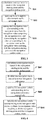
- Fig. 1 is a flow diagram illustrating a method for navigating according to an exemplary embodiment, as shown in Fig.1 , the method for navigating is used to the terminal or the network, the method includes step S11-S13 as follow:
- step S12 may be implement with three manners as follow:
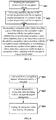
- Fig. 2 is a flow diagram illustrating a method for navigating according to another exemplary embodiment, as shown in Fig. 2 , step 12 includes:
- Fig. 3 is a flow diagram illustrating a method for navigating according to another exemplary embodiment, as shown in Fig. 3 , step 12 includes:
- the navigation starting point and the navigation ending point which the user inquired are A and B
- the corresponding navigation route is AB.
- There is navigation video CD shot for the navigation route CD (the navigation starting point is C and the navigation ending point is D)
- the navigation route AB is one section of the navigation route CD, so it can cut out the navigation video AB which is corresponding to the navigation route AB from the navigation video CD.
- the navigation parameter which is corresponding to the navigation video CD include the road name which is corresponding to the navigation route AB or identification of place A and place B, and the driving direction between place A and place B is A to B in the navigation video CD. So it can cut out the navigation video AB which is corresponding to the navigation route AB from the navigation video CD according to the road name which is corresponding to the navigation route AB or identification of place A and place B.
- the starting point which inquired is close to the ending point, it may have no navigation video entirely matching the user requirement, but there may be the navigation videos which include the navigation route, it can cut out the navigation video which is corresponding to the inquired route from these navigation video. So it will match the navigation video that is needed accurately for the user to improve the accuracy for navigation.
- Fig. 4 is a flow diagram illustrating a method for navigating according to another exemplary embodiment, as shown in Fig. 4 , step 12 includes:
- the starting point which inquired is far away from the ending point, it may have no navigation video entirely matching the user requirement, but there may be the navigation videos corresponding to the certain route between the navigation starting point and the navigation ending point respectively. So it can splice these navigation videos to obtain the navigation video which the user queried.
- the starting point and the ending point which the user queried are A and B
- the corresponding navigation route is AB. Dividing the navigation route AB into three navigation sub-routes AE, EF, EB.
- the navigation video AE, video EF, video EB which are corresponding to the navigation sub-routes have been queried respectively, splicing the three navigation videos to obtain the navigation video AB corresponding to the navigation route AB.
- the terminal may determine the parameters such as season and the like based on current date, and inquire the current weather parameter from the network, detect the current driving speed of the vehicle and so on. The more navigation parameters in the navigation request, the more accurate the navigation video which queried at last is.
- Fig. 5 is a flow diagram illustrating a method for navigating according to another exemplary embodiment, alternatively, the navigation request information further includes at least one of the following navigation parameters: a regional name, a road name, a season, a weather, an average driving speed, and a driving distance; in case that there are at least two navigation videos matching with the navigation starting point and the navigation ending point have been are obtained by querying, step S12 further includes:
- navigation videos there are three navigation videos matching with the navigation starting point A and the navigation ending point B, they are Video, Video2, and Video3 respectively.
- the navigation request information further includes:
- the navigation parameters of Video1, Video2, and Video3 as shown in Table 1 Table 1 Season Weather Average driving speed (km/h) Road name The matching degree with the navigation parameters of the navigation request information Video1 summer rainy 30 RoadA 75% Video2 spring sunny 60 RoadA 25% Video3 summer sunny 40 RoadB 50%
- the matching degree for Video1 and the navigation parameters of the navigation request information is highest, determining Video 1 as the navigation video which the user has queried. And it may also predetermine that pushing the navigation video which the matching degree is over 50%, or the navigation videos which the matching degree are top2 to the user and let the user select which navigation video to be used.
- the effects of shooting video is closely related to the factors such as season, weather, driving speed and the like. For example, when shooting the video at 6:00 PM, if shooting in summer, the effects is more clear due to the day is still bright, if shooting in winter, only the building with lighting or road markings can be shot clearly due to the day is already dark. Similarly, the effects of video which shot in weather such as rainy, snowy, fog and the like have much difference with the video which shot in sunny day. Moreover, since there may be difference in the roads between the same staring point and ending point, so the navigation video which has been shot is also different. In order to match the navigation video more accurate for the user, it need to consider the navigation parameters as many as possible.
- the method for navigating is provided in embodiments of the present disclosure, the executive bodies for practicing the method are server for navigating and terminal with navigate function.
- the method of the present disclosure may either be applied to the server on network or to the terminal.
- the terminal of the present embodiment may be any one of the devices with the function of playing video, such as mobile phone, computer, digital broadcasting terminal, message transceiver device, game console, tablet device, personal digital assistant and the like.
- the present embodiment arrange two implementations for navigating according to the different executive bodies, as follow:
- Fig. 6 is a flow diagram illustrating a method for navigating according to another exemplary embodiment, as shown in Fig.6 , the method includes steps as follow:
- the server need to push the navigation video which has been matched to the terminal which used to request. So it can store the navigation video data without plenty of storage space but consume certain data traffic.
- Fig. 7 is a flow diagram illustrating a method for navigating according to another exemplary embodiment, as shown in Fig.7 , the method includes steps as follow:
- the terminal pre-store a lot of navigation video data, it will consume the storage space of the terminal but save the data traffic of the terminal, since the querying is finished in local, the speed of processing is quicker.
- the server or the terminal is matching the navigation video, if there are many hours in the navigation video which has matched, the user can select when the terminal plays the navigation video.
- Fig. 8 is a flow diagram illustrating a method for navigating according to another exemplary embodiment, as shown in Fig.8 , alternatively, wherein when at least two navigation videos matching with the navigation request information are determined, executing the steps as follow:
- step S81 arranging and displaying the navigation video matching with the navigation request information ;
- the queried navigation videos are displayed for the user, and the user select to use which of the navigation videos, to enable the more intelligent navigation and the better user experience.
- Fig. 9 is a flow diagram illustrating a method for navigating according to another exemplary embodiment, as shown in Fig.9 , alternatively, executing the steps as follow:
- adjusting the playing speed of the navigation video based on the present driving speed during driving for example, when the user slows down, the playing speed of the navigation video is also speed down; when the user stops, the navigation video is stop playing; when the user accelerates, the playing speed of the navigation video is also speed up. So the playing speed is matched with the present driving speed.
- the picture that the user has viewed is the picture of the present road, it enable the more accurate effects of the navigation and the better user experience.
- the method further includes: synchronizing navigation data from a network, wherein the navigation data include the navigation video; storing the navigation data in a local navigation database.
- step S72 querying for the navigation video matching with the navigation request information from the local navigation database.
- it can synchronize the navigation data from the network in advance, for example, in WiFi, the user download the navigation video of current city or the region that needed, so when navigating in real-time, it will not have to consume the data traffic anymore.
- the processing of synchronizing the navigation data from the network may be periodic, for example, synchronizing per week.
- the method for generating a navigation video is provided in embodiments of the present disclosure, the method is applied to a terminal.
- the terminal of the present embodiment may be any one of the devices with the function of recording video, such as mobile phone, computer, digital broadcasting terminal, message transceiver device, game console, tablet device, personal digital assistant, tachograph and the like.
- Fig. 10 is a flow diagram illustrating a method for generating a navigation video according to an exemplary embodiment, as shown in Fig.10 , the method includes the steps as follow:
- the terminal is used to local shoot for the live-action, associate the navigation parameters to generate navigation video and send it to the server on network. So when the other user is driving on the same road, this navigation video can be used to navigate, it will reduce the reaction time for maps and various simplify identification for the user during driving, and it will more sensitive for the road conditions and directions, so that improve the accuracy for navigation and also improve the user experience.
- the method further includes:
- it can increase the average driving speed in navigation parameters, so when matching the navigation video in subsequent, the accuracy of matching is higher, so that the accuracy for navigation is improved.
- the terminal can record the navigation parameters like driving distance corresponding to the navigation video, in order to inquire the matching accurately in subsequent.
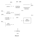
- Fig. 11 is a block diagram illustrating a device for navigating according to an exemplary embodiment.
- the device may be implemented as entire or a part of an electrical device by using hardware, software or any combination thereof.
- the device for navigating may include:
- Fig. 12 is a block diagram illustrating a determining module according to an exemplary embodiment, as shown in Fig. 12 , alternatively the navigation request information includes navigation parameters of a navigation starting point and a navigation ending point, the determining module 112 includes:
- Fig. 13 is a block diagram illustrating a determining module according to an exemplary embodiment, as shown in Fig. 13 , alternatively the navigation request information includes navigation parameters of a navigation starting point and a navigation ending point, the determining module 112 includes:
- Fig. 14 is a block diagram illustrating a determining module according to an exemplary embodiment, as shown in Fig. 14 , alternatively the navigation request information includes navigation parameters of a navigation starting point and a navigation ending point, the determining module 112 includes:
- Fig. 15 is a block diagram illustrating a determining module according to an exemplary embodiment, as shown in Fig. 15 , alternatively, the navigation request information further includes at least one of the following navigation parameters: a regional name, a road name, a season, a weather, an average driving speed, and a driving distance; and the determining module further includes:
- the navigating module is configured to send the navigation video to a terminal for playing when the device is applied to a network.
- the navigating module is configured to play the navigation video when the device is applied to a terminal.
- Fig. 16 is a block diagram illustrating a navigating module according to an exemplary embodiment, as shown in Fig. 16 , alternatively, the navigating module 113 includes:
- Fig. 17 is a block diagram illustrating a navigating module according to an exemplary embodiment, as shown in Fig. 17 , alternatively, the navigating module 113 includes:
- Fig. 18 is a block diagram illustrating a device for navigating according to another exemplary embodiment. As shown in Fig.18 , alternatively, the device further includes:
- Fig. 19 is a block diagram illustrating a device for generating a navigation video according to an exemplary embodiment. As shown in Fig.19 , the device includes:
- the method further includes:
- the embodiments of the present disclosure also provide a device for navigating, including:
- the embodiments of the present disclosure also provide a device for generating a navigation video, including:
- Fig. 20 is a block diagram illustrating a device for navigating or generating a navigation video according to an exemplary embodiment, the device is suitable for the terminal device.
- the device 2000 may be the video camera, recording device, mobile phone, computer, digital broadcasting terminal, message transceiver device, game console, tablet device, medical facility, fitness facility, personal digital assistant and the like.
- the device 2000 may include one or more of the following components: a processing component 2002, a memory 2004, a power component 2006, a multimedia component 2008, an audio component 2010, an input/output (I/O) interface 2012, a sensor component 2014, and a communication component 2016.
- the processing component 2002 typically controls overall operations of the device 2000, such as the operations associated with display, telephone calls, data communications, camera operations, and recording operations.
- the processing component 2002 may include one or more processors 2020 to execute instructions to perform all or part of the steps in the above described methods.
- the processing component 2002 may include one or more modules which facilitate the interaction between the processing component 2002 and other components.
- the processing component 2002 may include a multimedia module to facilitate the interaction between the multimedia component 2008 and the processing component 2002.
- the memory 2004 is configured to store various types of data to support the operation of the device 2000. Examples of such data include instructions for any applications or methods operated on the device 2000, contact data, phonebook data, messages, pictures, video, etc.
- the memory 2004 may be implemented using any type of volatile or non-volatile memory devices, or a combination thereof, such as a static random access memory (SRAM), an electrically erasable programmable read-only memory (EEPROM), an erasable programmable read-only memory (EPROM), a programmable read-only memory (PROM), a read-only memory (ROM), a magnetic memory, a flash memory, a magnetic or optical disk.
- SRAM static random access memory
- EEPROM electrically erasable programmable read-only memory
- EPROM erasable programmable read-only memory
- PROM programmable read-only memory
- ROM read-only memory
- magnetic memory a magnetic memory
- flash memory a flash memory
- magnetic or optical disk a magnetic or optical disk.
- the power component 2006 provides power to various components of the device 2000.
- the power component 2006 may include a power management system, one or more power sources, and any other components associated with the generation, management, and distribution of power for the device 2000.
- the multimedia component 2008 includes a screen providing an output interface between the device 2000 and the user.
- the screen may include a liquid crystal display (LCD) and a touch panel (TP). If the screen includes the touch panel, the screen may be implemented as a touch screen to receive input signals from the user.
- the touch panel includes one or more touch sensors to sense touches, swipes, and gestures on the touch panel. The touch sensors may not only sense a boundary of a touch or swipe action, but also sense a period of time and a pressure associated with the touch or swipe action.
- the multimedia component 2008 includes a front camera and/or a rear camera.
- the front camera and the rear camera may receive an external multimedia datum while the device 2000 is in an operation mode, such as a photographing mode or a video mode.
- an operation mode such as a photographing mode or a video mode.
- Each of the front camera and the rear camera may be a fixed optical lens system or have optical focusing and zooming capability.
- the audio component 2010 is configured to output and/or input audio signals.
- the audio component 2010 includes a microphone ("MIC") configured to receive an external audio signal when the device 2000 is in an operation mode, such as a call mode, a recording mode, and a voice recognition mode.
- the received audio signal may be further stored in the memory 2004 or transmitted via the communication component 2016.
- the audio component 2010 further includes a speaker to output audio signals.
- the I/O interface 2012 provides an interface between the processing component 2002 and peripheral interface modules, the peripheral interface modules being, for example, a keyboard, a click wheel, buttons, and the like.
- the buttons may include, but are not limited to, a home button, a volume button, a starting button, and a locking button.
- the sensor component 2014 includes one or more sensors to provide status assessments of various aspects of the device 2000. For instance, the sensor component 2014 may detect an open/closed status of the device 2000, relative positioning of components (e.g., the display and the keypad, of the device 2000), a change in position of the device 2000 or a component of the device 2000, a presence or absence of user contact with the device 2000, an orientation or an acceleration/deceleration of the device 2000, and a change in temperature of the device 2000.
- the sensor component 2014 may include a proximity sensor configured to detect the presence of a nearby object without any physical contact.
- the sensor component 2014 may also include a light sensor, such as a CMOS or CCD image sensor, for use in imaging applications.
- the sensor component 2014 may also include an accelerometer sensor, a gyroscope sensor, a magnetic sensor, a pressure sensor, or a temperature sensor.
- the communication component 2016 is configured to facilitate communication, wired or wirelessly, between the device 2000 and other devices.
- the device 2000 can access a wireless network based on a communication standard, such as WiFi, 2G, or 3G, or a combination thereof.
- the communication component 2016 receives a broadcast signal or broadcast associated information from an external broadcast management system via a broadcast channel.
- the communication component 2016 further includes a near field communication (NFC) module to facilitate short-range communications.
- the NFC module may be implemented based on a radio frequency identification (RFID) technology, an infrared data association (IrDA) technology, an ultra-wideband (UWB) technology, a Bluetooth (BT) technology, and other technologies.
- RFID radio frequency identification
- IrDA infrared data association
- UWB ultra-wideband
- BT Bluetooth
- the device 2000 may be implemented with one or more application specific integrated circuits (ASICs), digital signal processors (DSPs), digital signal processing devices (DSPDs), programmable logic devices (PLDs), field programmable gate arrays (FPGAs), controllers, micro-controllers, microprocessors, or other electronic components, for performing the above described methods.
- ASICs application specific integrated circuits
- DSPs digital signal processors
- DSPDs digital signal processing devices
- PLDs programmable logic devices
- FPGAs field programmable gate arrays
- controllers micro-controllers, microprocessors, or other electronic components, for performing the above described methods.
- non-transitory computer-readable storage medium including instructions, such as included in the memory 2004, executable by the processor 2020 in the device 2000, for performing the above-described methods.
- the non-transitory computer-readable storage medium may be a ROM, a RAM, a CD-ROM, a magnetic tape, a floppy disc, an optical data storage device, and the like.
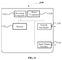
- FIG. 21 is a block diagram of a device for navigating according to an exemplary embodiment.
- the device 2100 may be a server.
- the device 2100 may include a processing component 2122 (e.g. one or more processors), and the memory resource represented by a memory 2132, which used to store the instructions executable by the processing component 2122, such as application.
- the application stored in memory 2132 includes one or more modules corresponding to the instructions.
- the processing component 2122 is configured to execute instructions, in order to execute the method above.
- the device 2100 may also include a power supply 2126 which configured to execute the power manager of the device 2100, a wired or wireless network interfaces 908 which configured to connect the apparatus 900 to network, and an input/output interface 2158.
- the device 2100 can be operated based on the operating systems stored in the memory 2132, such as Windows ServerTM, Mac OS XTM, UnixTM, LinuxTM, FreeBSDTM, or the like.
- the method further includes:
- the navigation request information includes navigation parameters of a navigation starting point and a navigation ending point
- the processing of determining the navigation video matching with the navigation request information includes:
- the navigation request information includes navigation parameters of a navigation starting point and a navigation ending point
- the processing of determining the navigation video matching with the navigation request information includes:
- the navigation request information includes navigation parameters of a navigation starting point and a navigation ending point
- the processing of determining the navigation video that matches the navigation request information includes:
- the navigation request information further includes at least one of the following navigation parameters: a regional name, a road name, a season, a weather, an average driving speed, a driving distance; in case that at least two navigation videos matching with the navigation starting point and the navigation ending point are obtained by querying, the processing of determining a navigation video matching with the navigation request information further includes:
- navigating according to the navigation video when the method is applied to a network including:
- navigating according to the navigation video when the method is applied to a terminal including:
- the processing of navigating based on the navigation video includes:
- the processing of navigating based on the navigation video includes:
Landscapes
- Engineering & Computer Science (AREA)
- Radar, Positioning & Navigation (AREA)
- Remote Sensing (AREA)
- Automation & Control Theory (AREA)
- Physics & Mathematics (AREA)
- General Physics & Mathematics (AREA)
- Multimedia (AREA)
- Theoretical Computer Science (AREA)
- Navigation (AREA)
- Instructional Devices (AREA)
- Traffic Control Systems (AREA)
Abstract
Description
- The present disclosure generally relates to the field of wireless communication technology, and more particularly to a method and device for navigating and a method and device for generating a navigation video.
- Currently, all the navigation systems are based on maps, the user need to identify the abstract maps and simplify identification during driving. Since some users aware of the maps slowly inborn, they are easily missed in complicated built environment or multi-intersections environment.
- Embodiments of the present disclosure provide a method and device for navigation and generating a navigation video. The technical solutions are as follows.
- According to a first aspect of the present disclosure, a method for navigating is provided, including: obtaining navigation request information; determining a navigation video matching with the navigation request information, wherein the navigation video is the video obtained from the location shooting of a road; navigating based on the navigation video.
- Alternatively, the navigation request information includes navigation parameters of a navigation starting point and a navigation ending point, the processing of determining the navigation video matching with the navigation request information includes: obtaining the navigation starting point and navigation ending point of the navigation video; determining a navigation video, both the navigation starting point and the navigation ending point of which are the same as those of the navigation request information as the navigation video matching with the navigation starting point and the navigation ending point.
- Alternatively, the navigation request information includes navigation parameters of a navigation starting point and a navigation ending point, the processing of determining the navigation video matching with the navigation request information includes: calculating a navigation route based on the navigation starting point and the navigation ending point; querying for a navigation video comprising the navigation route; cutting out a navigation video corresponding to the navigation route from the navigation video comprising the navigation route, and determining the navigation video corresponding to the navigation route as the navigation video matching with the navigation starting point and the navigation ending point.
- Alternatively, the navigation request information includes navigation parameters of a navigation starting point and a navigation ending point, the processing of determining the navigation video matching with the navigation request information includes: calculating a navigation route based on the navigation starting point and the navigation ending point; dividing the navigation route into at least two navigation sub-routes; inquiring the navigation videos corresponding to the navigation sub-routes respectively; splicing the navigation videos corresponding to the navigation sub-routes to obtain the navigation video matching with the navigation starting point and the navigation ending point.
- Alternatively, the navigation request information further includes at least one of the following navigation parameters: a region name, a road name, a season, weather, an average driving speed, and a driving distance; in case that at least two navigation videos matching with the navigation starting point and the navigation ending point are obtained by querying, the processing of determining a navigation video matching with the navigation request information includes: obtaining the navigation parameters of the navigation videos; calculating matching degrees of the navigation parameters of the navigation request information with respect to the navigation parameters of the navigation videos; determining a navigation video whose matching degree is the largest as the navigation video matching with the navigation request information, or determining navigation videos whose matching degrees are larger than a preset threshold as navigation videos matching with the navigation request information, or determining a predetermined number of navigation videos whose matching degrees are relatively high as navigation videos matching with the navigation request information.
- Alternatively, navigating according to the navigation video when the method is applied to a network, including: sending the navigation video to a terminal, for playing.
- Alternatively, navigating according to the navigation video when the method is applied to a terminal, including: playing the navigation video.
- Alternatively, wherein when at least two navigation videos matching with the navigation request information are determined, the processing of navigating based on the navigation video includes: arranging and displaying the navigation videos matching with the navigation request information; receiving an operation for selecting one of the navigation videos from a user; playing the navigation video.
- Alternatively, the processing of navigating based on the navigation video includes: obtaining a present driving speed; determining a playing speed of the navigation video based on the present driving speed; playing the navigation video at the playing speed.
- Alternatively, when the method is applied to terminal, including: synchronizing navigation data from the a network, wherein the navigation data include the navigation video; storing the navigation data in a local navigation database; the processing of determining the navigation video matching with the navigation request information includes: querying for the navigation video matching with the navigation request information from the local navigation database.
- According to a second aspect of embodiments of the present disclosure, a method for generating a navigation video is provided, including: obtaining navigation parameters entered by a user, wherein the navigation parameters comprise a navigation starting point and a navigation ending point; location shooting a road to obtain a shot video, wherein the shooting is stopped when the navigation ending point is reached; associating the navigation parameters with the shot video to obtain the navigation video; uploading the navigation video to a network.
- Alternatively, the method further includes: recording driving speed; calculating an average driving speed based on the driving speed; the processing of associating the navigation parameters with the shooting video includes: taking the average driving speed as a navigation parameter to associate it with the shot video.
- According to a third aspect of embodiments of the present disclosure, a device for navigating is provided, including: an obtaining module configured to obtain navigation request information; a determining module configured to determine a navigation video matching with the navigation request information, wherein the navigation video is a video obtained from location shooting of a road; a navigating module configured to navigate based on the navigation video.
- Alternatively, the navigation request information includes navigation parameters of a navigation starting point and a navigation ending point, the determining module includes: a first obtaining sub-module configured to obtain navigation starting points and navigation ending points of navigation videos; a determining sub-module configured to determine a navigation video, both the navigation starting point and the navigation ending point of which are the same as those of the navigation request information as the navigation video matching with the navigation starting point and the navigation ending point.
- Alternatively, the navigation request information includes navigation parameters of a navigation starting point and a navigation ending point, the determining module includes: a first computing sub-module configured to calculate a navigation route based on the navigation starting point and the navigation ending point; a querying sub-module configured to query for a navigation video comprising the navigation route; a cutting-out sub-module configured to cut out a navigation video corresponding to the navigation route from the navigation video comprising the navigation route, and determining the navigation video corresponding to the navigation route as the navigation video matching with the navigation starting point and the navigation ending point.
- Alternatively, the navigation request information includes navigation parameters of a navigation starting point and a navigation ending point, the determining module includes: a first computing sub-module configured to calculate a navigation route based on the navigation starting point and the navigation ending point; a dividing sub-module configured to divide the navigation route into at least two navigation sub-routes; an inquiring sub-module configured to query for navigation videos corresponding to the navigation sub-routes respectively; a splicing sub-module configured to splice the navigation videos corresponding to the navigation sub-routes to obtain the navigation video matching with the navigation starting point and the navigation ending point.
- Alternatively, wherein the navigation request information further comprises at least one of the following navigation parameters: a regional name, a road name, a season, weather, an average driving speed, and a driving distance; and the determining module includes: a second obtaining sub-module configured to, in case that at least two navigation videos matching with the navigation starting point and the navigation ending point are obtained by querying; configured to calculate matching degrees of the navigation parameters of the navigation request information with respect to the navigation parameters of the navigation videos; wherein the determining sub-module for determining a navigation video whose matching degree is the largest as the navigation video matching with the navigation request information, or determining navigation videos whose matching degrees are larger than a preset threshold as navigation videos matching with the navigation request information, or determining a predetermined number of navigation videos whose matching degrees are relatively high as navigation videos matching with the navigation request information.
- Alternatively, the navigating module is configured to send the navigation video to a terminal for playing when the device is applied to a network.
- Alternatively, the navigating module is configured to play the navigation video when the device is applied to a terminal.
- Alternatively, the navigating module includes: a displaying sub-module configured to, when at least two navigation videos matching with the navigation request information are determined, arrange and display the navigation videos matching with the navigation request information; a receiving sub-module configured to receive an operation for selecting one of the navigation videos from a user; a playing sub-module configured to play the selected navigation video.
- Alternatively, the navigation module includes: an obtaining sub-module configured to obtain a present driving speed; a determining sub-module configured to determine a playing speed of the navigation video based on the present driving speed; a playing sub-module configured to play the navigation video at the playing speed.
- Alternatively, the device further includes: a synchronizing module configured to synchronize navigation data from a network when the device is applied to a terminal, wherein the navigation data comprises the navigation video; a storing module configured to store the navigation data in a local navigation database; wherein the determining module is configured to query for the navigation video matching with the navigation request information from the local navigation database.
- According to a forth aspect of embodiments of the present disclosure, a device for generating a navigation video is provided, including: an obtaining module configured to obtain navigation parameters entered by a user, wherein the navigation parameters comprise a navigation starting point and a navigation ending point; a shooting module configured to location shoot a road to obtain a shot video, wherein the shooting is stopped when the navigation ending point is reached; an associating module configured to associate the navigation parameters with the shot video to obtain the navigation video; an uploading module configured to upload the navigation video to a network.
- Alternatively, the device further includes: a recording module configured to record driving speeds; a computing module configured to calculate an average driving speed based on the driving speeds; wherein the associating module is configured to take the average driving speed as a navigation parameter to associate it with the shot video.
- According to a fifth aspect of embodiments of the present disclosure, a device for navigating is provided, including: a processor; a memory for storing instructions executable by the processor; wherein the processor is configured to: obtain navigation request information; determine a navigation video matching with the navigation request information, wherein the navigation video is a video obtained from location shooting of a road; navigate based on the navigation video.
- According to a sixth aspect of embodiments of the present disclosure, a device for generating a navigation video is provided, including: a processor; a memory for storing instructions executable by the processor; wherein the processor is configured to: obtain navigation parameters entered by a user, wherein the navigation parameters comprise a navigation starting point and a navigation ending point; location shoot a road to obtain a shot video, wherein the shooting is stopped when the navigation ending point is reached; associate the navigation parameters with the shot video to obtain the navigation video; upload the navigation video to a network.
- Embodiments of the disclosure may provide at least some of the following beneficial effects: in the navigating technical solution above, navigating with the real video, it will reduce the reaction time for maps and various simplify identification for the user during driving, and with more sensitive for the road conditions and directions, it will navigate for the user more directly to avoid missing in complicated built environment or multi-intersections environment, so that improve the accuracy for navigation and also improve the user experience.
- In an exemplary embodiment, querying the corresponding navigation video according the navigation starting point and the navigation ending point of the navigation request information that can compare it with the navigation starting point and the navigation ending point of the navigation video directly, so it will get the navigation video which the user want query accurately.
- In an exemplary embodiment, if the starting point which queried is close to the ending point, it may have no navigation video entirely matching the user requirement, but there may be the navigation videos which include the navigation route, it can cut out the navigation video which is corresponding to the queried route from these navigation video. So it will match the navigation video that is needed accurately for the user to improve the accuracy for navigation.
- In an exemplary embodiment, by splicing the navigation video which needed for the user, it will match the navigation video that is needed accurately for the user to improve the accuracy for navigation.
- In an exemplary embodiment, by filtering the queried navigation videos with the parameters, it will provide more accurate navigation video whose matching degree is the largest which needed for the user to improve the accuracy for navigation and the user experience.
- In an exemplary embodiment, if the operation of matching the navigation video based on the navigation request information is finished by the server on the network, the server need to push the navigation video which has been matched to the terminal which used to request. So it can store the navigation video data without plenty of storage space but consume certain data traffic.
- In an exemplary embodiment, if the operation of matching the navigation video based on the navigation request information is finished by the terminal, the terminal pre-store a lot of navigation video data, it will consume the storage space of the terminal but save the data traffic of the terminal, since the querying is finished in local, the speed of processing is quicker.
- In an exemplary embodiment, the queried navigation videos are displayed for the user, and the user select to use which of the navigation videos, to enable the more intelligent navigation and the better user experience.
- In an exemplary embodiment, adjusting the playing speed of the navigation video based on the present driving speed during driving, so the playing speed is matched with the present driving speed. The picture that the user has viewed is the picture of the present road, it enable the more accurate effects of the navigation and the better user experience.
- In an exemplary embodiment, it can synchronize the navigation data from the network in advance, so when navigating in real-time, it will not have to consume the data traffic anymore. The processing of synchronizing the navigation data from the network may be periodic, for example, synchronizing per week.
- In the technical solution of generating a navigation video above, the terminal is used to local shoot for the live-action, associate the navigation parameters to generate navigation video and send it to the server on network. So when the other user is driving on the same road, this navigation video can be used to navigate, it will reduce the reaction time for maps and various simplify identification for the user during driving, and it will more sensitive for the road conditions and directions, so that improve the accuracy for navigation and also improve the user experience.
- In an exemplary embodiment, it can increase the average driving speed in navigation parameters, so when matching the navigation video in subsequent, the accuracy of matching is higher, so that the accuracy for navigation is improved.
- It is to be understood that both the forgoing general description and the following detailed description are exemplary only, and are not restrictive of the present disclosure.
- The accompanying drawings, which are incorporated in and constitute a part of this specification, illustrate embodiments consistent with the invention and, together with the description, serve to explain the principles of the invention.
-
Fig. 1 is a flow diagram illustrating a method for navigating according to an exemplary embodiment. -
Fig. 2 is a flow diagram illustrating a method for navigating according to another exemplary embodiment. -
Fig. 3 is a flow diagram illustrating a method for navigating according to another exemplary embodiment. -
Fig. 4 is a flow diagram illustrating a method for navigating according to another exemplary embodiment. -
Fig. 5 is a flow diagram illustrating a method for navigating according to another exemplary embodiment. -
Fig. 6 is a flow diagram illustrating a method for navigating according to another exemplary embodiment. -
Fig. 7 is a flow diagram illustrating a method for navigating according to another exemplary embodiment. -
Fig. 8 is a flow diagram illustrating a method for navigating according to another exemplary embodiment. -
Fig. 9 is a flow diagram illustrating a method for navigating according to another exemplary embodiment. -
Fig. 10 is a flow diagram illustrating a method for generating a navigation video according to an exemplary embodiment. -
Fig. 11 is a block diagram illustrating a device for navigating according to an exemplary embodiment. -
Fig. 12 is a block diagram illustrating a determining module according to an exemplary embodiment. -
Fig. 13 is a block diagram illustrating a determining module according to another exemplary embodiment. -
Fig. 14 is a block diagram illustrating a determining module according to another exemplary embodiment. -
Fig. 15 is a block diagram illustrating a determining module according to another exemplary embodiment. -
Fig. 16 is a block diagram illustrating a navigating module according to an exemplary embodiment. -
Fig. 17 is a block diagram illustrating a navigating module according to an exemplary embodiment. -
Fig. 18 is a block diagram illustrating a device for navigating according to another exemplary embodiment. -
Fig. 19 is a block diagram illustrating a device for generating a navigation video according to an exemplary embodiment. -
Fig. 20 is a block diagram illustrating a device for navigating or generating a navigation video according to an exemplary embodiment. -
Fig. 21 is a block diagram illustrating a device for navigating according to an exemplary embodiment. - Reference will now be made in detail to exemplary embodiments, examples of which are illustrated in the accompanying drawings. The following description refers to the accompanying drawings in which same numbers in different drawings represent same or similar elements unless otherwise described. The implementations set forth in the following description of exemplary embodiments do not represent all implementations consistent with the invention. Instead, they are merely examples of apparatuses and methods consistent with aspects related to the invention as recited in the appended claims.
- The embodiments of the present disclosure that navigate for user with the navigation video. The navigation video is the video which get from the location shooting for the road. Every navigation video has the corresponding navigation parameters, at least including: navigation starting point and navigation ending point, and further including: a regional name, a road name, a season, a weather, an average driving speed and the like. The user queries the corresponding navigation video by entering the navigation parameters of the navigation request, and the navigation video is played on the terminal. With navigating by the real video, it will reduce the reaction time for maps and various simplify identification for the user during driving, and it will more sensitive for the road conditions and directions, so that improve the accuracy for navigation and also improve the user experience.
- Wherein the navigation starting point and the navigation ending point may be entered by the user, or GPS may locate the current position as the navigation starting point automatically. The navigation parameters bellowing may be entered by the user, or obtaining the navigation parameters by GPS, detecting automatically, the navigation parameters may include at least one of: regional name, road name, season, weather, average driving speed, driving distance.
-
Fig. 1 is a flow diagram illustrating a method for navigating according to an exemplary embodiment, as shown inFig.1 , the method for navigating is used to the terminal or the network, the method includes step S11-S13 as follow: - in step S11, obtaining navigation request information;
- in step S12, determining a navigation video matching with the navigation request information, wherein the navigation video is the video obtained from the location shooting of the road;
- in step S13, navigating based on the navigation video.
- In the present embodiment, by navigating with the real video, it will reduce the reaction time for maps and various simplify identification for the user during driving, and with more sensitive for the road conditions and directions, it will navigate for the user more directly to avoid missing in complicated built environment or multi-intersections environment, so that improve the accuracy for navigation and also improve the user experience.
- Alternatively, the navigation request information includes navigation parameters of a navigation starting point and a navigation ending point, step S12 may be implement with three manners as follow:
-
Fig. 2 is a flow diagram illustrating a method for navigating according to another exemplary embodiment, as shown inFig. 2 , step 12 includes: - in step S21, obtaining navigation starting points and navigation ending points of the navigation videos;
- in step S22, determining a navigation video, both the navigation starting point and the navigation ending point of which are the same as those of the navigation request information as the navigation video matching with the navigation starting point and the navigation ending point.
- In an alternative solution, querying for the corresponding navigation video according the navigation starting point and the navigation ending point of the navigation request information that can compare it with the navigation starting point and the navigation ending point of the navigation video directly, so it will get the navigation video which the user want inquire accurately.
-
Fig. 3 is a flow diagram illustrating a method for navigating according to another exemplary embodiment, as shown inFig. 3 , step 12 includes: - in step S31, calculating a navigation route based on the navigation starting point and the navigation ending point;
- in step S32, querying for a navigation video comprising the navigation route;
- in step S33, cutting out a navigation video corresponding to the navigation route from the navigation video comprising the navigation route, and determining the navigation video corresponding to the navigation route as the navigation video matching with the navigation starting point and the navigation ending point.
- For example, the navigation starting point and the navigation ending point which the user inquired are A and B, the corresponding navigation route is AB. There is navigation video CD shot for the navigation route CD (the navigation starting point is C and the navigation ending point is D), and the navigation route AB is one section of the navigation route CD, so it can cut out the navigation video AB which is corresponding to the navigation route AB from the navigation video CD.
- Wherein, the navigation parameter which is corresponding to the navigation video CD include the road name which is corresponding to the navigation route AB or identification of place A and place B, and the driving direction between place A and place B is A to B in the navigation video CD. So it can cut out the navigation video AB which is corresponding to the navigation route AB from the navigation video CD according to the road name which is corresponding to the navigation route AB or identification of place A and place B.
- In an alternative solution, if the starting point which inquired is close to the ending point, it may have no navigation video entirely matching the user requirement, but there may be the navigation videos which include the navigation route, it can cut out the navigation video which is corresponding to the inquired route from these navigation video. So it will match the navigation video that is needed accurately for the user to improve the accuracy for navigation.
-
Fig. 4 is a flow diagram illustrating a method for navigating according to another exemplary embodiment, as shown inFig. 4 , step 12 includes: - in step S41, calculating a navigation route based on the navigation starting point and the navigation ending point;
- in step S42, dividing the navigation route into at least two navigation sub-routes;
- in step S43, querying for the navigation videos corresponding to the navigation sub-routes respectively;
- in step S44, splicing the navigation videos corresponding to the navigation sub-routes to obtain the navigation video matching with the navigation starting point and the navigation ending point.
- In an alternative solution, if the starting point which inquired is far away from the ending point, it may have no navigation video entirely matching the user requirement, but there may be the navigation videos corresponding to the certain route between the navigation starting point and the navigation ending point respectively. So it can splice these navigation videos to obtain the navigation video which the user queried. For example, the starting point and the ending point which the user queried are A and B, the corresponding navigation route is AB. Dividing the navigation route AB into three navigation sub-routes AE, EF, EB. The navigation video AE, video EF, video EB which are corresponding to the navigation sub-routes have been queried respectively, splicing the three navigation videos to obtain the navigation video AB corresponding to the navigation route AB.
- In an alternative solution, by splicing the navigation video which needed for the user, it will match the navigation video that is needed accurately for the user to improve the accuracy for navigation.
- In order to improve the accuracy for matching the navigation video, it can increase the terms of the parameters that entered, for example, entering regional name, road name and the like, the terminal may determine the parameters such as season and the like based on current date, and inquire the current weather parameter from the network, detect the current driving speed of the vehicle and so on. The more navigation parameters in the navigation request, the more accurate the navigation video which queried at last is.
-
Fig. 5 is a flow diagram illustrating a method for navigating according to another exemplary embodiment, alternatively, the navigation request information further includes at least one of the following navigation parameters: a regional name, a road name, a season, a weather, an average driving speed, and a driving distance; in case that there are at least two navigation videos matching with the navigation starting point and the navigation ending point have been are obtained by querying, step S12 further includes: - in step S51, obtaining the navigation parameters of the navigation videos;
- in step S52, calculating the matching degrees of the navigation parameters of the navigation request information with respect to the navigation parameters of the navigation videos;
- in step S53, determining a navigation video whose matching degree is the largest as the navigation video matching with the navigation request information, or determining navigation videos whose matching degrees are larger than a preset threshold as navigation videos matching with the navigation request information, or determining a predetermined number of navigation videos whose matching degrees are relatively high as navigation videos matching with the navigation request information.
- For example, there are three navigation videos matching with the navigation starting point A and the navigation ending point B, they are Video, Video2, and Video3 respectively.
- The navigation request information further includes:
- The navigation parameters of Video1, Video2, and Video3 as shown in Table 1:
Table 1 Season Weather Average driving speed (km/h) Road name The matching degree with the navigation parameters of the navigation request information Video1 summer rainy 30 RoadA 75% Video2 spring sunny 60 RoadA 25% Video3 summer sunny 40 RoadB 50% - From Table 1, the matching degree for Video1 and the navigation parameters of the navigation request information is highest, determining Video 1 as the navigation video which the user has queried. And it may also predetermine that pushing the navigation video which the matching degree is over 50%, or the navigation videos which the matching degree are top2 to the user and let the user select which navigation video to be used.
- Since the effects of shooting video is closely related to the factors such as season, weather, driving speed and the like. For example, when shooting the video at 6:00 PM, if shooting in summer, the effects is more clear due to the day is still bright, if shooting in winter, only the building with lighting or road markings can be shot clearly due to the day is already dark. Similarly, the effects of video which shot in weather such as rainy, snowy, fog and the like have much difference with the video which shot in sunny day. Moreover, since there may be difference in the roads between the same staring point and ending point, so the navigation video which has been shot is also different. In order to match the navigation video more accurate for the user, it need to consider the navigation parameters as many as possible.
- In an alternative solution, by filtering the queried navigation videos with the parameters, it will provide more accurate navigation video whose matching degree is the largest which needed for the user, to improve the accuracy for navigation and the user experience.
- The method for navigating is provided in embodiments of the present disclosure, the executive bodies for practicing the method are server for navigating and terminal with navigate function. The method of the present disclosure may either be applied to the server on network or to the terminal. The terminal of the present embodiment may be any one of the devices with the function of playing video, such as mobile phone, computer, digital broadcasting terminal, message transceiver device, game console, tablet device, personal digital assistant and the like.
- The present embodiment arrange two implementations for navigating according to the different executive bodies, as follow:
-
Fig. 6 is a flow diagram illustrating a method for navigating according to another exemplary embodiment, as shown inFig.6 , the method includes steps as follow: - in step S61, the server receives navigation request information sent by a terminal;
- in step S62, the server determines a navigation video matching with the navigation request information;
- in step S63, the server sends the navigation video to the terminal, and the terminal plays the navigation video for the user to navigate.
- In an alternative solution, if the operation of matching the navigation video based on the navigation request information is finished by the server on the network, the server need to push the navigation video which has been matched to the terminal which used to request. So it can store the navigation video data without plenty of storage space but consume certain data traffic.
-
Fig. 7 is a flow diagram illustrating a method for navigating according to another exemplary embodiment, as shown inFig.7 , the method includes steps as follow: - in step S71, the terminal receives a navigation request information entered by the user;
- in step S72, the terminal determines the navigation video matching with the navigation request information;
- in step S73, the terminal plays the navigation video for navigating.
- In an alternative solution, if the operation of matching the navigation video based on the navigation request information is finished by the terminal, the terminal pre-store a lot of navigation video data, it will consume the storage space of the terminal but save the data traffic of the terminal, since the querying is finished in local, the speed of processing is quicker.
- No matter the server or the terminal is matching the navigation video, if there are many hours in the navigation video which has matched, the user can select when the terminal plays the navigation video.
-
Fig. 8 is a flow diagram illustrating a method for navigating according to another exemplary embodiment, as shown inFig.8 , alternatively, wherein when at least two navigation videos matching with the navigation request information are determined, executing the steps as follow: - in step S81, arranging and displaying the navigation video matching with the navigation request information ;
- in step S82, receiving an operation for selecting one of the navigation videos from a user;
- in step S83, playing the selected navigation video.
- In an alternative solution, the queried navigation videos are displayed for the user, and the user select to use which of the navigation videos, to enable the more intelligent navigation and the better user experience.
- In order to improve the effects of navigation, adjusting the playing speed of the navigation video based on the driving speed during driving.
-
Fig. 9 is a flow diagram illustrating a method for navigating according to another exemplary embodiment, as shown inFig.9 , alternatively, executing the steps as follow: - in step S91, obtaining a present driving speed;
- in step S92, determining a playing speed of the navigation video based on the present driving speed;
- in step S93, playing the navigation video at the playing speed.
- In an alternative solution, adjusting the playing speed of the navigation video based on the present driving speed during driving, for example, when the user slows down, the playing speed of the navigation video is also speed down; when the user stops, the navigation video is stop playing; when the user accelerates, the playing speed of the navigation video is also speed up. So the playing speed is matched with the present driving speed. The picture that the user has viewed is the picture of the present road, it enable the more accurate effects of the navigation and the better user experience.
- Alternatively, the method further includes: synchronizing navigation data from a network, wherein the navigation data include the navigation video; storing the navigation data in a local navigation database. In step S72 described above, querying for the navigation video matching with the navigation request information from the local navigation database.
- In an alternative solution, it can synchronize the navigation data from the network in advance, for example, in WiFi, the user download the navigation video of current city or the region that needed, so when navigating in real-time, it will not have to consume the data traffic anymore. The processing of synchronizing the navigation data from the network may be periodic, for example, synchronizing per week.
- The method for generating a navigation video is provided in embodiments of the present disclosure, the method is applied to a terminal. The terminal of the present embodiment may be any one of the devices with the function of recording video, such as mobile phone, computer, digital broadcasting terminal, message transceiver device, game console, tablet device, personal digital assistant, tachograph and the like.
-
Fig. 10 is a flow diagram illustrating a method for generating a navigation video according to an exemplary embodiment, as shown inFig.10 , the method includes the steps as follow: - in step S101, obtaining navigation parameters entered by a user, wherein the navigation parameters include navigation starting point and navigation ending point;
- in step S102, location shooting a road to obtain a shot video, wherein the shooting is stopped when the navigation ending point is reached;
- in step S103, associating the navigation parameters with the shot video to obtain the navigation video;
- in step S104, uploading the navigation video to a network.
- In the present embodiment, the terminal is used to local shoot for the live-action, associate the navigation parameters to generate navigation video and send it to the server on network. So when the other user is driving on the same road, this navigation video can be used to navigate, it will reduce the reaction time for maps and various simplify identification for the user during driving, and it will more sensitive for the road conditions and directions, so that improve the accuracy for navigation and also improve the user experience.
- Alternatively, the method further includes:
- recording driving speeds; calculating an average driving speed based on the driving speeds;
- the step S103 further includes: taking the average driving speed as a navigation parameter to associate it with the shot video.
- In an alternative solution, it can increase the average driving speed in navigation parameters, so when matching the navigation video in subsequent, the accuracy of matching is higher, so that the accuracy for navigation is improved.
- Additionally, the terminal can record the navigation parameters like driving distance corresponding to the navigation video, in order to inquire the matching accurately in subsequent.
- The following is the embodiments of a device which can execute the embodiments of the method of the present disclosure.
-
Fig. 11 is a block diagram illustrating a device for navigating according to an exemplary embodiment. The device may be implemented as entire or a part of an electrical device by using hardware, software or any combination thereof. As shown inFig. 11 , the device for navigating may include: - an obtaining
module 111 configured to obtain navigation request information; - a determining
module 112 configured to determine a navigation video matching with the navigation request information, wherein the navigation video is the video obtained from location shooting of a road; - a navigating
module 113 configured to navigate based on the navigation video. -
Fig. 12 is a block diagram illustrating a determining module according to an exemplary embodiment, as shown inFig. 12 , alternatively the navigation request information includes navigation parameters of a navigation starting point and a navigation ending point, the determiningmodule 112 includes: - a first obtaining sub-module 121 configured to obtain the navigation starting points and navigation ending points of the navigation videos;
- a determining sub-module 122 configured to determine a navigation video, both the navigation starting point and the navigation ending point of which are the same as those of the navigation request information as the navigation video matching with the navigation starting point and the navigation ending point.
-
Fig. 13 is a block diagram illustrating a determining module according to an exemplary embodiment, as shown inFig. 13 , alternatively the navigation request information includes navigation parameters of a navigation starting point and a navigation ending point, the determiningmodule 112 includes: - a first calculating sub-module 131 configured to calculate a navigation route based on the navigation starting point and the navigation ending point;
- an querying sub-module 132 configured to query for the navigation video which includes the navigation route;
- a cutting-out sub-module 133 configured to cut out a navigation video corresponding to the navigation route from the navigation video which includes the navigation route, and determining the navigation video corresponding to the navigation route as the navigation video matching with the navigation starting point and the navigation ending point.
-
Fig. 14 is a block diagram illustrating a determining module according to an exemplary embodiment, as shown inFig. 14 , alternatively the navigation request information includes navigation parameters of a navigation starting point and a navigation ending point, the determiningmodule 112 includes: - a first calculating 131 sub-module configured to calculate a navigation route based on the navigation starting point and the navigation ending point;
- a dividing sub-module 142 configured to divide the navigation route into at least two navigation sub-routes;
- an querying sub-module 143 configured to query for the navigation videos corresponding to the navigation sub-routes respectively;
- a
splicing sub-module 144 configured to splice the navigation videos corresponding to the navigation sub-routes to obtain the navigation video matching with the navigation starting point and the navigation ending point. -
Fig. 15 is a block diagram illustrating a determining module according to an exemplary embodiment, as shown inFig. 15 , alternatively, the navigation request information further includes at least one of the following navigation parameters: a regional name, a road name, a season, a weather, an average driving speed, and a driving distance; and the determining module further includes: - a second obtaining sub-module 151 configured to, in case that at least two navigation videos matching with the navigation starting point and the navigation ending point are obtained by querying;
- a second calculating sub-module 152 configured to calculate the matching degrees for the navigation parameters of the navigation request information with respect to the navigation parameters of the navigation videos;
- the determining sub-module 122 configured to determine a navigation video whose matching degree is the largest as the navigation video matching with the navigation request information, or determining navigation videos whose matching degrees are larger than a preset threshold as navigation videos matching with the navigation request information, or determining a predetermined number of navigation videos whose matching degrees are relatively high as navigation videos matching with the navigation request information.
- Alternatively, the navigating module is configured to send the navigation video to a terminal for playing when the device is applied to a network.
- Alternatively, the navigating module is configured to play the navigation video when the device is applied to a terminal.
-
Fig. 16 is a block diagram illustrating a navigating module according to an exemplary embodiment, as shown inFig. 16 , alternatively, the navigatingmodule 113 includes: - a displaying sub-module 161 configured to arrange and display the navigation videos matching with the navigation request information when at least two navigation videos matching with the navigation request information are determined;
- a receiving sub-module 162 configured to receive an operation for selecting one of the navigation video from a user;
- a playing sub-module 163 configured to play the selected navigation video.
-
Fig. 17 is a block diagram illustrating a navigating module according to an exemplary embodiment, as shown inFig. 17 , alternatively, the navigatingmodule 113 includes: - an obtaining sub-module 171 configured to obtain a present driving speed;
- a determining sub-module 172 configured to determine a playing speed of the navigation video based on the present driving speed;
- a playing sub-module 173 configured to play the navigation video at the playing speed.
-
Fig. 18 is a block diagram illustrating a device for navigating according to another exemplary embodiment. As shown inFig.18 , alternatively, the device further includes: - a
synchronizing module 114 configured to synchronize navigation data from the a network when the device is applied to a terminal, the navigation data include the navigation video; - a
storing module 115 configured to store the navigation data in a local navigation database; - wherein the determining
module 112 is configured to query for the navigation video matching with the navigation request information from the local navigation database. -
Fig. 19 is a block diagram illustrating a device for generating a navigation video according to an exemplary embodiment. As shown inFig.19 , the device includes: - an obtaining
module 191 configured to obtain navigation parameters entered by a user, the navigation parameters include a navigation starting point and a navigation ending point; - a
shooting module 192 configured to location shoot a road to obtain a shot video, wherein the shooting is stopped when the navigation ending point is reached; - an associating
module 193 configured to associate the navigation parameters with the shot video to obtain the navigation video; - an
uploading module 194 configured to upload the navigation video to a network. - As shown in
Fig. 19 , alternatively, the method further includes: - a
recording module 195 configured to record driving speeds; - a calculating
module 196 configured to calculate an average driving speed based on the driving speeds; - the associating
module 193 configured to take the average driving speed as a navigation parameter to associate it with the shot video. - The embodiments of the present disclosure also provide a device for navigating, including:
- a processor;
- a memory for storing instructions executable by the processor;
- wherein the processor is configured to:
- obtain navigation request information;
- determine a navigation video matching with the navigation request information, wherein the navigation video is the video obtained from the location shooting of the road;
- navigate based on the navigation video.
- The embodiments of the present disclosure also provide a device for generating a navigation video, including:
- a processor;
- a memory for storing instructions executable by the processor;
- wherein the processor is configured to:
- obtain navigation parameters entered by a user, wherein the navigation parameters include a navigation starting point and a navigation ending point;
- location shoot a road to obtain a shot video, wherein the shooting is stopped when the navigation ending point is reached;
- associate the navigation parameters with the shot video to obtain the navigation video;
- upload the navigation video to a network.
- With respect to the devices in the above embodiments, the specific manners that the respective modules perform operations have been described in detail in the embodiments regarding the relevant methods, and will not be elaborated herein.
-
Fig. 20 is a block diagram illustrating a device for navigating or generating a navigation video according to an exemplary embodiment, the device is suitable for the terminal device. For example, thedevice 2000 may be the video camera, recording device, mobile phone, computer, digital broadcasting terminal, message transceiver device, game console, tablet device, medical facility, fitness facility, personal digital assistant and the like. - The
device 2000 may include one or more of the following components: aprocessing component 2002, amemory 2004, apower component 2006, amultimedia component 2008, anaudio component 2010, an input/output (I/O)interface 2012, asensor component 2014, and acommunication component 2016. - The
processing component 2002 typically controls overall operations of thedevice 2000, such as the operations associated with display, telephone calls, data communications, camera operations, and recording operations. Theprocessing component 2002 may include one ormore processors 2020 to execute instructions to perform all or part of the steps in the above described methods. Moreover, theprocessing component 2002 may include one or more modules which facilitate the interaction between theprocessing component 2002 and other components. For instance, theprocessing component 2002 may include a multimedia module to facilitate the interaction between themultimedia component 2008 and theprocessing component 2002. - The
memory 2004 is configured to store various types of data to support the operation of thedevice 2000. Examples of such data include instructions for any applications or methods operated on thedevice 2000, contact data, phonebook data, messages, pictures, video, etc. Thememory 2004 may be implemented using any type of volatile or non-volatile memory devices, or a combination thereof, such as a static random access memory (SRAM), an electrically erasable programmable read-only memory (EEPROM), an erasable programmable read-only memory (EPROM), a programmable read-only memory (PROM), a read-only memory (ROM), a magnetic memory, a flash memory, a magnetic or optical disk. - The
power component 2006 provides power to various components of thedevice 2000. Thepower component 2006 may include a power management system, one or more power sources, and any other components associated with the generation, management, and distribution of power for thedevice 2000. - The
multimedia component 2008 includes a screen providing an output interface between thedevice 2000 and the user. In some embodiments, the screen may include a liquid crystal display (LCD) and a touch panel (TP). If the screen includes the touch panel, the screen may be implemented as a touch screen to receive input signals from the user. The touch panel includes one or more touch sensors to sense touches, swipes, and gestures on the touch panel. The touch sensors may not only sense a boundary of a touch or swipe action, but also sense a period of time and a pressure associated with the touch or swipe action. In some embodiments, themultimedia component 2008 includes a front camera and/or a rear camera. The front camera and the rear camera may receive an external multimedia datum while thedevice 2000 is in an operation mode, such as a photographing mode or a video mode. Each of the front camera and the rear camera may be a fixed optical lens system or have optical focusing and zooming capability. - The
audio component 2010 is configured to output and/or input audio signals. For example, theaudio component 2010 includes a microphone ("MIC") configured to receive an external audio signal when thedevice 2000 is in an operation mode, such as a call mode, a recording mode, and a voice recognition mode. The received audio signal may be further stored in thememory 2004 or transmitted via thecommunication component 2016. In some embodiments, theaudio component 2010 further includes a speaker to output audio signals. - The I/
O interface 2012 provides an interface between theprocessing component 2002 and peripheral interface modules, the peripheral interface modules being, for example, a keyboard, a click wheel, buttons, and the like. The buttons may include, but are not limited to, a home button, a volume button, a starting button, and a locking button. - The
sensor component 2014 includes one or more sensors to provide status assessments of various aspects of thedevice 2000. For instance, thesensor component 2014 may detect an open/closed status of thedevice 2000, relative positioning of components (e.g., the display and the keypad, of the device 2000), a change in position of thedevice 2000 or a component of thedevice 2000, a presence or absence of user contact with thedevice 2000, an orientation or an acceleration/deceleration of thedevice 2000, and a change in temperature of thedevice 2000. Thesensor component 2014 may include a proximity sensor configured to detect the presence of a nearby object without any physical contact. Thesensor component 2014 may also include a light sensor, such as a CMOS or CCD image sensor, for use in imaging applications. In some embodiments, thesensor component 2014 may also include an accelerometer sensor, a gyroscope sensor, a magnetic sensor, a pressure sensor, or a temperature sensor. - The
communication component 2016 is configured to facilitate communication, wired or wirelessly, between thedevice 2000 and other devices. Thedevice 2000 can access a wireless network based on a communication standard, such as WiFi, 2G, or 3G, or a combination thereof. In an exemplary embodiment, thecommunication component 2016 receives a broadcast signal or broadcast associated information from an external broadcast management system via a broadcast channel. In an exemplary embodiment, thecommunication component 2016 further includes a near field communication (NFC) module to facilitate short-range communications. For example, the NFC module may be implemented based on a radio frequency identification (RFID) technology, an infrared data association (IrDA) technology, an ultra-wideband (UWB) technology, a Bluetooth (BT) technology, and other technologies. - In exemplary embodiments, the
device 2000 may be implemented with one or more application specific integrated circuits (ASICs), digital signal processors (DSPs), digital signal processing devices (DSPDs), programmable logic devices (PLDs), field programmable gate arrays (FPGAs), controllers, micro-controllers, microprocessors, or other electronic components, for performing the above described methods. - In exemplary embodiments, there is also provided a non-transitory computer-readable storage medium including instructions, such as included in the
memory 2004, executable by theprocessor 2020 in thedevice 2000, for performing the above-described methods. For example, the non-transitory computer-readable storage medium may be a ROM, a RAM, a CD-ROM, a magnetic tape, a floppy disc, an optical data storage device, and the like. -
FIG. 21 is a block diagram of a device for navigating according to an exemplary embodiment. For example, thedevice 2100 may be a server. Thedevice 2100 may include a processing component 2122 (e.g. one or more processors), and the memory resource represented by amemory 2132, which used to store the instructions executable by theprocessing component 2122, such as application. The application stored inmemory 2132 includes one or more modules corresponding to the instructions. Additionally, theprocessing component 2122 is configured to execute instructions, in order to execute the method above. - The
device 2100 may also include apower supply 2126 which configured to execute the power manager of thedevice 2100, a wired or wireless network interfaces 908 which configured to connect the apparatus 900 to network, and an input/output interface 2158. Thedevice 2100 can be operated based on the operating systems stored in thememory 2132, such as Windows Server™, Mac OS X™, Unix™, Linux™, FreeBSD™, or the like. - A non-transitory computer readable storage medium having stored therein instructions that, when executed by the processor of the
device 2000, causes thedevice 2000 to perform the above described method for generating a navigation video, including: - obtaining navigation parameters entered by a user, the navigation parameters include navigation starting point and navigation ending point;
- location shooting for road, stop shooting when arrived the navigation ending point to obtain a shooting video;
- associating the navigation parameters with the shooting video to obtain a navigation video;
- uploading the navigation video to network.
- Alternatively, the method further includes:
- recording driving speed;
- calculating an average driving speed based on the driving speed;
- the processing of associating the navigation parameters with the shooting video includes: taking the average driving speed as a navigation parameter to associate it with the shot video.
- A non-transitory computer readable storage medium having stored therein instructions that, when executed by the processor of the
device 2000 or thedevice 2100, causes thedevice 2000 or thedevice 2100 to perform the above described method for navigating, including: - obtaining navigation request information;
- determining a navigation video matching with the navigation request information, wherein the navigation video is a video obtained from location shooting of a road;
- navigating based on the navigation video.
- Alternatively, the navigation request information includes navigation parameters of a navigation starting point and a navigation ending point, the processing of determining the navigation video matching with the navigation request information includes:
- obtaining navigation starting points and navigation ending points of navigation videos;
- determining a navigation video, both the navigation starting point and the navigation ending point of which are the same as those of the navigation request information as the navigation video matching with the navigation starting point and the navigation ending point.
- Alternatively, the navigation request information includes navigation parameters of a navigation starting point and a navigation ending point, the processing of determining the navigation video matching with the navigation request information includes:
- calculating a navigation route based on the navigation starting point and the navigation ending point;
- querying for the navigation video which including the navigation route;
- cutting out a navigation video corresponding to the navigation route from the navigation video including the navigation route, and determining the navigation video corresponding to the navigation route as the navigation video matching with the navigation starting point and the navigation ending point.
- Alternatively, the navigation request information includes navigation parameters of a navigation starting point and a navigation ending point, the processing of determining the navigation video that matches the navigation request information includes:
- calculating a navigation route based on the navigation starting point and the navigation ending point;
- dividing the navigation route into at least two navigation sub-routes;
- querying for the navigation videos corresponding to the navigation sub-routes respectively;
- splicing the navigation videos corresponding to the navigation sub-routes to obtain the navigation video matching with the navigation starting point and the navigation ending point.
- Alternatively, the navigation request information further includes at least one of the following navigation parameters: a regional name, a road name, a season, a weather, an average driving speed, a driving distance;
in case that at least two navigation videos matching with the navigation starting point and the navigation ending point are obtained by querying, the processing of determining a navigation video matching with the navigation request information further includes: - obtaining the navigation parameters of the navigation videos;
- calculating the matching degrees of the navigation parameters of the navigation request information with respect to the navigation parameters of the navigation videos;
- determining a navigation video whose matching degree is the largest as the navigation video matching with the navigation request information, or determining navigation videos whose matching degrees are larger than a preset threshold as navigation videos matching with the navigation request information, or determining a predetermined number of navigation videos whose matching degrees are relatively high as navigation videos matching with the navigation request information.
- Alternatively, navigating according to the navigation video when the method is applied to a network, including:
- sending the navigation video to a terminal for playing.
- Alternatively, navigating according to the navigation video when the method is applied to a terminal, including:
- playing the navigation video.
- Alternatively, wherein when at least two navigation videos matching with the navigation request information are determined, the processing of navigating based on the navigation video includes:
- arranging and displaying the navigation videos matching with the navigation request information;
- receiving an operation for selecting one of the navigation videos from a user;
- playing the navigation video.
- Alternatively, the processing of navigating based on the navigation video includes:
- obtaining a present driving speed;
- determining a playing speed of the navigation video based on the present driving speed;
- playing the navigation video at the playing speed.
- Alternatively, when the method is applied to terminal, including:
- synchronizing navigation data from the a network, wherein the navigation data include the navigation video; storing the navigation data in a local navigation database;
- the processing of determining the navigation video matching with the navigation request information includes:
- querying for the navigation video matching with the navigation request information from the local navigation database.
- Other embodiments of the invention will be apparent to those skilled in the art from consideration of the specification and practice of the disclosures herein. This application is intended to cover any variations, uses, or adaptations of the disclosure following the general principles thereof and including such departures from the present disclosure as come within known or customary practice in the art. It is intended that the specification and examples be considered as exemplary only, with a true scope of the invention being indicated by the following claims.
- It will be appreciated that the inventive concept is not limited to the exact construction that has been described above and illustrated in the accompanying drawings, and that various modifications and changes can be made without departing from the scope thereof. It is intended that the scope of the invention only be limited by the appended claims.
Claims (16)
- A method for navigating, characterized by the steps of:obtaining (S11) navigation request information;determining (S12) a navigation video matching with the navigation request information, wherein the navigation video is a video obtained from location shooting of a road;navigating (S13) based on the navigation video.
- The method of claim 1, wherein the navigation request information comprises navigation parameters of a navigation starting point and a navigation ending point, and the processing of determining a navigation video matching with the navigation request information comprises:obtaining (S21) navigation starting points and navigation ending points of navigation videos;determining (S22) a navigation video, both the navigation starting point and the navigation ending point of which are the same as those of the navigation request information, as the navigation video matching the navigation starting point and the navigation ending point;or the processing of determining a navigation video matching with the navigation request information comprises:calculating (S31) a navigation route based on the navigation starting point and the navigation ending point;querying (S32) for a navigation video comprising the navigation route;cutting out (S33) a navigation video corresponding to the navigation route from the navigation video comprising the navigation route, and determining the navigation video corresponding to the navigation route as the navigation video matching with the navigation starting point and the navigation ending point;or the processing of determining a navigation video matching with the navigation request information comprises:calculating (S41) a navigation route based on the navigation starting point and the navigation ending point;dividing (S42) the navigation route into at least two navigation sub-routes;querying (S43) for navigation videos corresponding to the navigation sub-routes respectively;splicing (S44) the navigation videos corresponding to the navigation sub-routes to obtain the navigation video matching with the navigation starting point and the navigation ending point.
- The method of claim 2, wherein the navigation request information further comprises at least one of the following navigation parameters: a region name, a road name, a season, weather, an average driving speed, and a driving distance;
when at least two navigation videos matching with the navigation starting point and the navigation ending point are obtained by querying, the processing of determining a navigation video matching with the navigation request information further comprises:obtaining (S51) the navigation parameters of the navigation videos;calculating (S52) matching degrees of the navigation parameters of the navigation request information with respect to the navigation parameters of the navigation videos;determining (S53) a navigation video whose matching degree is the largest as the navigation video matching with the navigation request information, or determining navigation videos whose matching degrees are larger than a preset threshold as navigation videos matching with the navigation request information, or determining a predetermined number of navigation videos whose matching degrees are relatively high as navigation videos matching with the navigation request information. - The method of claim 1, wherein when the method is applied to a network, the processing of navigating based on the navigation video comprises:sending (S63) the navigation video to a terminal for playing.
- The method of claim 1, wherein when the method is applied to a terminal, the processing of navigating based on the navigation video comprises:playing (S73) the navigation video;or when at least two navigation videos matching with the navigation request information are determined, the processing of navigating based on the navigation video comprises:arranging and displaying (S81) the navigation videos matching with the navigation request information;receiving (S82) an operation for selecting one of the navigation videos from a user;playing (S83) the selected navigation video;or the processing of navigating based on the navigation video comprises:obtaining (S91) a present driving speed;determining (S92) a playing speed of the navigation video based on the present driving speed;playing (S93) the navigation video at the playing speed.
- The method of claim 1, when the method is applied to a terminal, the method comprising:synchronizing navigation data from a network, wherein the navigation data comprises the navigation video;storing the navigation data in a local navigation database;the processing of determining a navigation video matching with the navigation request information comprises:querying for the navigation video matching with the navigation request information from the local navigation database.
- A method for generating a navigation video, characterized by the steps of:obtaining (S101) navigation parameters entered by a user, wherein the navigation parameters comprise a navigation starting point and a navigation ending point;location shooting (S102) a road to obtain a shot video, wherein the shooting is stopped when the navigation ending point is reached;associating (S103) the navigation parameters with the shot video to obtain the navigation video;uploading (S104) the navigation video to a network.
- The method of claim 7, further comprising:recording driving speeds;calculating an average driving speed based on the driving speeds;the processing of associating the navigation parameters with the shot video comprises:taking the average driving speed as a navigation parameter to associate it with the shot video.
- A device for navigating, characterized by:an obtaining module (111) configured to obtain navigation request information;a determining module (112) configured to determine a navigation video matching with the navigation request information, wherein the navigation video is a video obtained from location shooting of a road;a navigating module (113) configured to navigate based on the navigation video.
- The device of claim 9, wherein the navigation request information comprises navigation parameters of a navigation starting point and a navigation ending point, and the determining module (112) comprises:a first obtaining sub-module (121) configured to obtain navigation starting points and navigation ending points of navigation videos;a determining sub-module (122) configured to determine a navigation video, both the navigation starting point and the navigation ending point of which are the same as those of the navigation request information, as the navigation video matching with the navigation starting point and the navigation ending point;or the determining module (112) comprises:a first calculating sub-module (131) configured to calculate a navigation route based on the navigation starting point and the navigation ending point;an querying sub-module (132) configured to query for a navigation video comprising the navigation route;a cutting-out sub-module (133) configured to cut out a navigation video corresponding to the navigation route from the navigation video comprising the navigation route, and determining the navigation video corresponding to the navigation route as the navigation video matching with the navigation starting point and the navigation ending point;or the determining module (112) comprises:a first calculating sub-module (141) configured to calculate a navigation route based on the navigation starting point and the navigation ending point;a dividing sub-module (142) configured to divide the navigation route into at least two navigation sub-routes;a querying sub-module (143) configured to query for navigation videos corresponding to the navigation sub-routes respectively;a splicing sub-module (144) configured to splice the navigation videos corresponding to the navigation sub-routes to obtain the navigation video matching with the navigation starting point and the navigation ending point.
- The device of claim 10, wherein the navigation request information further comprises at least one of the following navigation parameters: a regional name, a road name, a season, weather, an average driving speed, and a driving distance; and the determining module (112) comprises:a second obtaining sub-module (151) configured to, in case that at least two navigation videos matching with the navigation starting point and the navigation ending point are obtained by querying, obtain the navigation parameters of the navigation videos;a second calculating sub-module (152) configured to calculate matching degrees of the navigation parameters of the navigation request information with respect to the navigation parameters of the navigation videos; whereinthe determining sub-module (122) is configured to determine a navigation video whose matching degree is the largest as the navigation video matching with the navigation request information, or determine navigation videos whose matching degree are larger than a preset threshold as navigation videos matching with the navigation request information, or determine a predetermined number of navigation videos whose matching degrees are relatively high as navigation videos matching with the navigation request information.
- The device of claim 9, wherein the navigating module (113) is configured to send the navigation video to a terminal for playing when the device is applied to a network.
- The device of claim 9, wherein the navigating module (113) is configured to play the navigation video when the device is applied to a terminal, and
the navigating module (113) comprises:a displaying sub-module (161) configured to, when at least two navigation videos matching with the navigation request information are determined, arrange and display the navigation videos matching with the navigation request information;a receiving sub-module (162) configured to receive an operation for selecting one of the navigation videos from a user;a playing sub-module (163) configured to play the selected navigation video;or the navigating module (113) comprises:an obtaining sub-module (171) configured to obtain a present driving speed;a determining sub-module (172) configured to determine a playing speed of the navigation video based on the present driving speed;a playing sub-module (173) configured to play the navigation video at the playing speed. - The device of claim 9, further comprising:a synchronizing module (114) configured to synchronize navigation data from a network when the device is applied to a terminal, wherein the navigation data comprises the navigation video;a storing module (115) configured to store the navigation data in a local navigation database;wherein the determining module (112) is configured to query for the navigation video matching with the navigation request information from the local navigation database.
- A device for generating a navigation video, characterized by:an obtaining module (191) configured to obtain navigation parameters entered by a user, wherein the navigation parameters comprise a navigation starting point and a navigation ending point;a shooting module (192) configured to location shoot a road to obtain a shot video, wherein the shooting is stopped when the navigation ending point is reached;an associating module (193) configured to associate the navigation parameters with the shot video to obtain the navigation video;an uploading module (194) configured to upload the navigation video to a network.
- The device of claim 15, further comprising:a recording module (195) configured to record driving speeds;a calculating module (196) configured to calculate an average driving speed based on the driving speeds;wherein the associating module (193) is configured to take the average driving speed as a navigation parameter to associate it with the shot video.
Applications Claiming Priority (1)
| Application Number | Priority Date | Filing Date | Title |
|---|---|---|---|
| CN201510609516.0A CN105222802A (en) | 2015-09-22 | 2015-09-22 | navigation, navigation video generation method and device |
Publications (3)
| Publication Number | Publication Date |
|---|---|
| EP3156767A2 true EP3156767A2 (en) | 2017-04-19 |
| EP3156767A3 EP3156767A3 (en) | 2017-07-05 |
| EP3156767B1 EP3156767B1 (en) | 2020-11-04 |
Family
ID=54991890
Family Applications (1)
| Application Number | Title | Priority Date | Filing Date |
|---|---|---|---|
| EP16188955.5A Active EP3156767B1 (en) | 2015-09-22 | 2016-09-15 | Method and device for navigating and method and device for generating a navigation video |
Country Status (8)
| Country | Link |
|---|---|
| US (1) | US20170082451A1 (en) |
| EP (1) | EP3156767B1 (en) |
| JP (1) | JP2017538948A (en) |
| KR (1) | KR20180048221A (en) |
| CN (1) | CN105222802A (en) |
| MX (1) | MX2016004211A (en) |
| RU (1) | RU2630709C1 (en) |
| WO (1) | WO2017049796A1 (en) |
Cited By (3)
| Publication number | Priority date | Publication date | Assignee | Title |
|---|---|---|---|---|
| DE102018003249A1 (en) | 2018-04-20 | 2018-09-27 | Daimler Ag | Method for integrated video image display on a display device of a navigation system |
| DE102018008560A1 (en) | 2018-10-30 | 2019-03-28 | Daimler Ag | navigation system |
| US20220276068A1 (en) * | 2021-09-30 | 2022-09-01 | Beijing Baidu Netcom Science Technology Co., Ltd. | Navigation method, navigation apparatus, device and storage medium |
Families Citing this family (15)
| Publication number | Priority date | Publication date | Assignee | Title |
|---|---|---|---|---|
| CN105222773B (en) * | 2015-09-29 | 2018-09-21 | 小米科技有限责任公司 | Air navigation aid and device |
| CN105828288A (en) * | 2016-03-21 | 2016-08-03 | 乐视网信息技术(北京)股份有限公司 | Multimedia control method and device |
| CN107402019A (en) * | 2016-05-19 | 2017-11-28 | 北京搜狗科技发展有限公司 | The method, apparatus and server of a kind of video navigation |
| CN105973227A (en) * | 2016-06-21 | 2016-09-28 | 上海磐导智能科技有限公司 | Visual live navigation method |
| CN107576332B (en) * | 2016-07-04 | 2020-08-04 | 百度在线网络技术(北京)有限公司 | Transfer navigation method and device |
| CN107621265A (en) * | 2016-07-14 | 2018-01-23 | 百度在线网络技术(北京)有限公司 | A kind of method and apparatus for carrying out indoor navigation |
| CN108020231A (en) * | 2016-10-28 | 2018-05-11 | 大辅科技(北京)有限公司 | A kind of map system and air navigation aid based on video |
| CN109983760B (en) * | 2016-11-22 | 2021-12-21 | 大众汽车(中国)投资有限公司 | Video processing method and device |
| CN107588782A (en) * | 2017-08-25 | 2018-01-16 | 上海与德科技有限公司 | The drive manner and system of a kind of virtual navigation |
| CN110646002B (en) * | 2018-06-27 | 2021-07-06 | 百度在线网络技术(北京)有限公司 | Method and apparatus for processing information |
| JP7275556B2 (en) * | 2018-12-14 | 2023-05-18 | トヨタ自動車株式会社 | Information processing system, program, and information processing method |
| DE102019206250A1 (en) * | 2019-05-01 | 2020-11-05 | Siemens Schweiz Ag | Regulation and control of the running speed of a video |
| CN111735473B (en) * | 2020-07-06 | 2022-04-19 | 无锡广盈集团有限公司 | Beidou navigation system capable of uploading navigation information |
| CN114370884A (en) * | 2021-12-16 | 2022-04-19 | 北京三快在线科技有限公司 | Navigation method and device, electronic equipment and readable storage medium |
| CN114844987B (en) * | 2022-04-02 | 2024-09-10 | 咪咕音乐有限公司 | Panoramic navigation method, device, equipment and storage medium |
Family Cites Families (25)
| Publication number | Priority date | Publication date | Assignee | Title |
|---|---|---|---|---|
| US5982298A (en) * | 1996-11-14 | 1999-11-09 | Microsoft Corporation | Interactive traffic display and trip planner |
| US6133853A (en) * | 1998-07-30 | 2000-10-17 | American Calcar, Inc. | Personal communication and positioning system |
| AUPP152098A0 (en) * | 1998-01-28 | 1998-02-19 | Joyce Russ Advertising Pty Ltd | Navigational apparatus using visual description of the route |
| JP2003046969A (en) * | 2001-07-30 | 2003-02-14 | Sony Corp | Information processing device and method therefor, recording medium, and program |
| DE10151354A1 (en) * | 2001-10-22 | 2003-05-08 | Andreas Berger | Information and navigation system for motor vehicle provides information containing image and/or video sequences of vehicle route that are output to information device |
| JP2004005493A (en) * | 2002-04-24 | 2004-01-08 | Vehicle Information & Communication System Center | Driver assist information transmitter, driver assist information receiver and driver assist information providing system |
| US20030210806A1 (en) * | 2002-05-07 | 2003-11-13 | Hitachi, Ltd. | Navigational information service with image capturing and sharing |
| GB0215217D0 (en) * | 2002-06-29 | 2002-08-14 | Spenwill Ltd | Position referenced multimedia authoring and playback |
| JP2005140638A (en) * | 2003-11-06 | 2005-06-02 | Mitsubishi Electric Corp | Navigation system, road image information preparation device, road image information using system using the same, and recording medium |
| JP4503393B2 (en) * | 2004-08-10 | 2010-07-14 | 省吾 吉村 | Destination guide device, program and recording medium thereof |
| US7177761B2 (en) * | 2004-10-27 | 2007-02-13 | Navteq North America, Llc | Map display for a navigation system |
| US20070150188A1 (en) * | 2005-05-27 | 2007-06-28 | Outland Research, Llc | First-person video-based travel planning system |
| DE102006056874B4 (en) * | 2006-12-01 | 2015-02-12 | Siemens Aktiengesellschaft | navigation device |
| CN101459808A (en) * | 2007-12-10 | 2009-06-17 | 英业达股份有限公司 | Video recording method for combined positioning system |
| US20090254265A1 (en) * | 2008-04-08 | 2009-10-08 | Thimmannagari Chandra Reddy | Video map technology for navigation |
| US20110102637A1 (en) * | 2009-11-03 | 2011-05-05 | Sony Ericsson Mobile Communications Ab | Travel videos |
| CN101719130A (en) * | 2009-11-25 | 2010-06-02 | 中兴通讯股份有限公司 | Implementation method of Street View and implementation system thereof |
| JP2013134225A (en) * | 2011-12-27 | 2013-07-08 | Nomura Research Institute Ltd | Navigation device, system, method, and computer program |
| CN102679989A (en) * | 2012-05-23 | 2012-09-19 | 李杰波 | Navigation method for logistics distribution and logistics distribution truck applied by same |
| US8666655B2 (en) * | 2012-07-30 | 2014-03-04 | Aleksandr Shtukater | Systems and methods for navigation |
| JP5958228B2 (en) * | 2012-09-21 | 2016-07-27 | 株式会社Jvcケンウッド | Video information providing apparatus and method |
| CN104180814A (en) * | 2013-05-22 | 2014-12-03 | 北京百度网讯科技有限公司 | Navigation method in live-action function on mobile terminal, and electronic map client |
| CN104897164A (en) * | 2014-03-06 | 2015-09-09 | 宇龙计算机通信科技(深圳)有限公司 | Video map sharing method, and apparatus and system thereof |
| CN104266654A (en) * | 2014-09-26 | 2015-01-07 | 广东好帮手电子科技股份有限公司 | Vehicle real scene navigation system and method |
| CN104729520B (en) * | 2015-03-18 | 2018-08-07 | 广东好帮手电子科技股份有限公司 | A kind of navigation recorder and method based on track record and time search |
-
2015
- 2015-09-22 CN CN201510609516.0A patent/CN105222802A/en active Pending
- 2015-12-29 RU RU2016112333A patent/RU2630709C1/en active
- 2015-12-29 MX MX2016004211A patent/MX2016004211A/en unknown
- 2015-12-29 JP JP2017541156A patent/JP2017538948A/en active Pending
- 2015-12-29 KR KR1020167005586A patent/KR20180048221A/en not_active Application Discontinuation
- 2015-12-29 WO PCT/CN2015/099304 patent/WO2017049796A1/en active Application Filing
-
2016
- 2016-09-14 US US15/265,621 patent/US20170082451A1/en not_active Abandoned
- 2016-09-15 EP EP16188955.5A patent/EP3156767B1/en active Active
Non-Patent Citations (1)
| Title |
|---|
| None |
Cited By (4)
| Publication number | Priority date | Publication date | Assignee | Title |
|---|---|---|---|---|
| DE102018003249A1 (en) | 2018-04-20 | 2018-09-27 | Daimler Ag | Method for integrated video image display on a display device of a navigation system |
| DE102018008560A1 (en) | 2018-10-30 | 2019-03-28 | Daimler Ag | navigation system |
| US20220276068A1 (en) * | 2021-09-30 | 2022-09-01 | Beijing Baidu Netcom Science Technology Co., Ltd. | Navigation method, navigation apparatus, device and storage medium |
| US12078502B2 (en) * | 2021-09-30 | 2024-09-03 | Beijing Baidu Netcom Science Technology Co., Ltd. | Navigation method, navigation apparatus, device and storage medium |
Also Published As
| Publication number | Publication date |
|---|---|
| KR20180048221A (en) | 2018-05-10 |
| MX2016004211A (en) | 2017-11-15 |
| RU2630709C1 (en) | 2017-09-12 |
| EP3156767A3 (en) | 2017-07-05 |
| CN105222802A (en) | 2016-01-06 |
| JP2017538948A (en) | 2017-12-28 |
| US20170082451A1 (en) | 2017-03-23 |
| EP3156767B1 (en) | 2020-11-04 |
| WO2017049796A1 (en) | 2017-03-30 |
Similar Documents
| Publication | Publication Date | Title |
|---|---|---|
| EP3156767B1 (en) | Method and device for navigating and method and device for generating a navigation video | |
| CN107957266B (en) | Positioning method, positioning device and storage medium | |
| KR101712301B1 (en) | Method and device for shooting a picture | |
| US10292004B2 (en) | Method, device and medium for acquiring location information | |
| US20170155958A1 (en) | Method, Apparatus and System for Playing Multimedia Data, and Storage Medium | |
| EP3173970A1 (en) | Image processing method and apparatus | |
| US10110800B2 (en) | Method and apparatus for setting image capturing parameters | |
| CN106250430B (en) | Method and device for sorting intelligent device list | |
| CN109029479B (en) | Navigation reminding method and device, electronic equipment and computer readable storage medium | |
| EP3128774A1 (en) | Methods, devices and system for accessing network | |
| US20170171706A1 (en) | Device displaying method, apparatus, and storage medium | |
| CN104065878A (en) | Method, device and terminal for controlling shooting | |
| CN104902086A (en) | Alarm clock ringing method and device | |
| US10248855B2 (en) | Method and apparatus for identifying gesture | |
| EP3352453B1 (en) | Photographing method for intelligent flight device and intelligent flight device | |
| EP3599581A1 (en) | Method and apparatus for displaying a commodity | |
| CN105911573A (en) | Aerial device retrieving method and device | |
| CN110536012A (en) | The method and device of the outer playback amount of controlling terminal | |
| US20180122421A1 (en) | Method, apparatus and computer-readable medium for video editing and video shooting | |
| CN105488074B (en) | Photo clustering method and device | |
| CN108133181B (en) | Method for acquiring indication information, AR device and storage medium | |
| CN105049899B (en) | television projection control method, device and terminal device | |
| US20180062934A1 (en) | Method and apparatus for device identification | |
| CN110996047A (en) | Pet tracking shooting method, device and system and computer readable storage medium | |
| CN109961646B (en) | Road condition information error correction method and device |
Legal Events
| Date | Code | Title | Description |
|---|---|---|---|
| PUAI | Public reference made under article 153(3) epc to a published international application that has entered the european phase |
Free format text: ORIGINAL CODE: 0009012 |
|
| STAA | Information on the status of an ep patent application or granted ep patent |
Free format text: STATUS: THE APPLICATION HAS BEEN PUBLISHED |
|
| AK | Designated contracting states |
Kind code of ref document: A2 Designated state(s): AL AT BE BG CH CY CZ DE DK EE ES FI FR GB GR HR HU IE IS IT LI LT LU LV MC MK MT NL NO PL PT RO RS SE SI SK SM TR |
|
| AX | Request for extension of the european patent |
Extension state: BA ME |
|
| PUAL | Search report despatched |
Free format text: ORIGINAL CODE: 0009013 |
|
| AK | Designated contracting states |
Kind code of ref document: A3 Designated state(s): AL AT BE BG CH CY CZ DE DK EE ES FI FR GB GR HR HU IE IS IT LI LT LU LV MC MK MT NL NO PL PT RO RS SE SI SK SM TR |
|
| AX | Request for extension of the european patent |
Extension state: BA ME |
|
| RIC1 | Information provided on ipc code assigned before grant |
Ipc: G01C 21/36 20060101AFI20170601BHEP |
|
| STAA | Information on the status of an ep patent application or granted ep patent |
Free format text: STATUS: REQUEST FOR EXAMINATION WAS MADE |
|
| 17P | Request for examination filed |
Effective date: 20180105 |
|
| RBV | Designated contracting states (corrected) |
Designated state(s): AL AT BE BG CH CY CZ DE DK EE ES FI FR GB GR HR HU IE IS IT LI LT LU LV MC MK MT NL NO PL PT RO RS SE SI SK SM TR |
|
| STAA | Information on the status of an ep patent application or granted ep patent |
Free format text: STATUS: EXAMINATION IS IN PROGRESS |
|
| 17Q | First examination report despatched |
Effective date: 20180308 |
|
| GRAP | Despatch of communication of intention to grant a patent |
Free format text: ORIGINAL CODE: EPIDOSNIGR1 |
|
| STAA | Information on the status of an ep patent application or granted ep patent |
Free format text: STATUS: GRANT OF PATENT IS INTENDED |
|
| INTG | Intention to grant announced |
Effective date: 20200612 |
|
| RIN1 | Information on inventor provided before grant (corrected) |
Inventor name: ZHENG, ZHIGUANG Inventor name: XIE, LONG Inventor name: LIU, GUOMING |
|
| GRAS | Grant fee paid |
Free format text: ORIGINAL CODE: EPIDOSNIGR3 |
|
| GRAA | (expected) grant |
Free format text: ORIGINAL CODE: 0009210 |
|
| STAA | Information on the status of an ep patent application or granted ep patent |
Free format text: STATUS: THE PATENT HAS BEEN GRANTED |
|
| AK | Designated contracting states |
Kind code of ref document: B1 Designated state(s): AL AT BE BG CH CY CZ DE DK EE ES FI FR GB GR HR HU IE IS IT LI LT LU LV MC MK MT NL NO PL PT RO RS SE SI SK SM TR |
|
| REG | Reference to a national code |
Ref country code: GB Ref legal event code: FG4D |
|
| REG | Reference to a national code |
Ref country code: CH Ref legal event code: EP |
|
| REG | Reference to a national code |
Ref country code: AT Ref legal event code: REF Ref document number: 1331410 Country of ref document: AT Kind code of ref document: T Effective date: 20201115 |
|
| REG | Reference to a national code |
Ref country code: IE Ref legal event code: FG4D |
|
| REG | Reference to a national code |
Ref country code: DE Ref legal event code: R096 Ref document number: 602016047031 Country of ref document: DE |
|
| REG | Reference to a national code |
Ref country code: NL Ref legal event code: MP Effective date: 20201104 |
|
| REG | Reference to a national code |
Ref country code: AT Ref legal event code: MK05 Ref document number: 1331410 Country of ref document: AT Kind code of ref document: T Effective date: 20201104 |
|
| PG25 | Lapsed in a contracting state [announced via postgrant information from national office to epo] |
Ref country code: NO Free format text: LAPSE BECAUSE OF FAILURE TO SUBMIT A TRANSLATION OF THE DESCRIPTION OR TO PAY THE FEE WITHIN THE PRESCRIBED TIME-LIMIT Effective date: 20210204 Ref country code: PT Free format text: LAPSE BECAUSE OF FAILURE TO SUBMIT A TRANSLATION OF THE DESCRIPTION OR TO PAY THE FEE WITHIN THE PRESCRIBED TIME-LIMIT Effective date: 20210304 Ref country code: RS Free format text: LAPSE BECAUSE OF FAILURE TO SUBMIT A TRANSLATION OF THE DESCRIPTION OR TO PAY THE FEE WITHIN THE PRESCRIBED TIME-LIMIT Effective date: 20201104 Ref country code: GR Free format text: LAPSE BECAUSE OF FAILURE TO SUBMIT A TRANSLATION OF THE DESCRIPTION OR TO PAY THE FEE WITHIN THE PRESCRIBED TIME-LIMIT Effective date: 20210205 Ref country code: FI Free format text: LAPSE BECAUSE OF FAILURE TO SUBMIT A TRANSLATION OF THE DESCRIPTION OR TO PAY THE FEE WITHIN THE PRESCRIBED TIME-LIMIT Effective date: 20201104 |
|
| PG25 | Lapsed in a contracting state [announced via postgrant information from national office to epo] |
Ref country code: PL Free format text: LAPSE BECAUSE OF FAILURE TO SUBMIT A TRANSLATION OF THE DESCRIPTION OR TO PAY THE FEE WITHIN THE PRESCRIBED TIME-LIMIT Effective date: 20201104 Ref country code: IS Free format text: LAPSE BECAUSE OF FAILURE TO SUBMIT A TRANSLATION OF THE DESCRIPTION OR TO PAY THE FEE WITHIN THE PRESCRIBED TIME-LIMIT Effective date: 20210304 Ref country code: LV Free format text: LAPSE BECAUSE OF FAILURE TO SUBMIT A TRANSLATION OF THE DESCRIPTION OR TO PAY THE FEE WITHIN THE PRESCRIBED TIME-LIMIT Effective date: 20201104 Ref country code: BG Free format text: LAPSE BECAUSE OF FAILURE TO SUBMIT A TRANSLATION OF THE DESCRIPTION OR TO PAY THE FEE WITHIN THE PRESCRIBED TIME-LIMIT Effective date: 20210204 Ref country code: AT Free format text: LAPSE BECAUSE OF FAILURE TO SUBMIT A TRANSLATION OF THE DESCRIPTION OR TO PAY THE FEE WITHIN THE PRESCRIBED TIME-LIMIT Effective date: 20201104 Ref country code: ES Free format text: LAPSE BECAUSE OF FAILURE TO SUBMIT A TRANSLATION OF THE DESCRIPTION OR TO PAY THE FEE WITHIN THE PRESCRIBED TIME-LIMIT Effective date: 20201104 Ref country code: SE Free format text: LAPSE BECAUSE OF FAILURE TO SUBMIT A TRANSLATION OF THE DESCRIPTION OR TO PAY THE FEE WITHIN THE PRESCRIBED TIME-LIMIT Effective date: 20201104 |
|
| REG | Reference to a national code |
Ref country code: LT Ref legal event code: MG9D |
|
| PG25 | Lapsed in a contracting state [announced via postgrant information from national office to epo] |
Ref country code: HR Free format text: LAPSE BECAUSE OF FAILURE TO SUBMIT A TRANSLATION OF THE DESCRIPTION OR TO PAY THE FEE WITHIN THE PRESCRIBED TIME-LIMIT Effective date: 20201104 |
|
| PG25 | Lapsed in a contracting state [announced via postgrant information from national office to epo] |
Ref country code: RO Free format text: LAPSE BECAUSE OF FAILURE TO SUBMIT A TRANSLATION OF THE DESCRIPTION OR TO PAY THE FEE WITHIN THE PRESCRIBED TIME-LIMIT Effective date: 20201104 Ref country code: SK Free format text: LAPSE BECAUSE OF FAILURE TO SUBMIT A TRANSLATION OF THE DESCRIPTION OR TO PAY THE FEE WITHIN THE PRESCRIBED TIME-LIMIT Effective date: 20201104 Ref country code: EE Free format text: LAPSE BECAUSE OF FAILURE TO SUBMIT A TRANSLATION OF THE DESCRIPTION OR TO PAY THE FEE WITHIN THE PRESCRIBED TIME-LIMIT Effective date: 20201104 Ref country code: CZ Free format text: LAPSE BECAUSE OF FAILURE TO SUBMIT A TRANSLATION OF THE DESCRIPTION OR TO PAY THE FEE WITHIN THE PRESCRIBED TIME-LIMIT Effective date: 20201104 Ref country code: LT Free format text: LAPSE BECAUSE OF FAILURE TO SUBMIT A TRANSLATION OF THE DESCRIPTION OR TO PAY THE FEE WITHIN THE PRESCRIBED TIME-LIMIT Effective date: 20201104 Ref country code: SM Free format text: LAPSE BECAUSE OF FAILURE TO SUBMIT A TRANSLATION OF THE DESCRIPTION OR TO PAY THE FEE WITHIN THE PRESCRIBED TIME-LIMIT Effective date: 20201104 |
|
| REG | Reference to a national code |
Ref country code: DE Ref legal event code: R097 Ref document number: 602016047031 Country of ref document: DE |
|
| PG25 | Lapsed in a contracting state [announced via postgrant information from national office to epo] |
Ref country code: DK Free format text: LAPSE BECAUSE OF FAILURE TO SUBMIT A TRANSLATION OF THE DESCRIPTION OR TO PAY THE FEE WITHIN THE PRESCRIBED TIME-LIMIT Effective date: 20201104 |
|
| PLBE | No opposition filed within time limit |
Free format text: ORIGINAL CODE: 0009261 |
|
| STAA | Information on the status of an ep patent application or granted ep patent |
Free format text: STATUS: NO OPPOSITION FILED WITHIN TIME LIMIT |
|
| 26N | No opposition filed |
Effective date: 20210805 |
|
| PG25 | Lapsed in a contracting state [announced via postgrant information from national office to epo] |
Ref country code: NL Free format text: LAPSE BECAUSE OF FAILURE TO SUBMIT A TRANSLATION OF THE DESCRIPTION OR TO PAY THE FEE WITHIN THE PRESCRIBED TIME-LIMIT Effective date: 20201104 Ref country code: IT Free format text: LAPSE BECAUSE OF FAILURE TO SUBMIT A TRANSLATION OF THE DESCRIPTION OR TO PAY THE FEE WITHIN THE PRESCRIBED TIME-LIMIT Effective date: 20201104 Ref country code: AL Free format text: LAPSE BECAUSE OF FAILURE TO SUBMIT A TRANSLATION OF THE DESCRIPTION OR TO PAY THE FEE WITHIN THE PRESCRIBED TIME-LIMIT Effective date: 20201104 |
|
| PG25 | Lapsed in a contracting state [announced via postgrant information from national office to epo] |
Ref country code: SI Free format text: LAPSE BECAUSE OF FAILURE TO SUBMIT A TRANSLATION OF THE DESCRIPTION OR TO PAY THE FEE WITHIN THE PRESCRIBED TIME-LIMIT Effective date: 20201104 |
|
| REG | Reference to a national code |
Ref country code: CH Ref legal event code: PL |
|
| REG | Reference to a national code |
Ref country code: BE Ref legal event code: MM Effective date: 20210930 |
|
| PG25 | Lapsed in a contracting state [announced via postgrant information from national office to epo] |
Ref country code: IS Free format text: LAPSE BECAUSE OF FAILURE TO SUBMIT A TRANSLATION OF THE DESCRIPTION OR TO PAY THE FEE WITHIN THE PRESCRIBED TIME-LIMIT Effective date: 20210304 Ref country code: MC Free format text: LAPSE BECAUSE OF FAILURE TO SUBMIT A TRANSLATION OF THE DESCRIPTION OR TO PAY THE FEE WITHIN THE PRESCRIBED TIME-LIMIT Effective date: 20201104 |
|
| PG25 | Lapsed in a contracting state [announced via postgrant information from national office to epo] |
Ref country code: LU Free format text: LAPSE BECAUSE OF NON-PAYMENT OF DUE FEES Effective date: 20210915 Ref country code: IE Free format text: LAPSE BECAUSE OF NON-PAYMENT OF DUE FEES Effective date: 20210915 Ref country code: BE Free format text: LAPSE BECAUSE OF NON-PAYMENT OF DUE FEES Effective date: 20210930 |
|
| PG25 | Lapsed in a contracting state [announced via postgrant information from national office to epo] |
Ref country code: LI Free format text: LAPSE BECAUSE OF NON-PAYMENT OF DUE FEES Effective date: 20210930 Ref country code: CH Free format text: LAPSE BECAUSE OF NON-PAYMENT OF DUE FEES Effective date: 20210930 |
|
| PG25 | Lapsed in a contracting state [announced via postgrant information from national office to epo] |
Ref country code: HU Free format text: LAPSE BECAUSE OF FAILURE TO SUBMIT A TRANSLATION OF THE DESCRIPTION OR TO PAY THE FEE WITHIN THE PRESCRIBED TIME-LIMIT; INVALID AB INITIO Effective date: 20160915 |
|
| P01 | Opt-out of the competence of the unified patent court (upc) registered |
Effective date: 20230523 |
|
| PG25 | Lapsed in a contracting state [announced via postgrant information from national office to epo] |
Ref country code: CY Free format text: LAPSE BECAUSE OF FAILURE TO SUBMIT A TRANSLATION OF THE DESCRIPTION OR TO PAY THE FEE WITHIN THE PRESCRIBED TIME-LIMIT Effective date: 20201104 |
|
| PGFP | Annual fee paid to national office [announced via postgrant information from national office to epo] |
Ref country code: GB Payment date: 20230920 Year of fee payment: 8 |
|
| PGFP | Annual fee paid to national office [announced via postgrant information from national office to epo] |
Ref country code: FR Payment date: 20230928 Year of fee payment: 8 Ref country code: DE Payment date: 20230920 Year of fee payment: 8 |
|
| PG25 | Lapsed in a contracting state [announced via postgrant information from national office to epo] |
Ref country code: MK Free format text: LAPSE BECAUSE OF FAILURE TO SUBMIT A TRANSLATION OF THE DESCRIPTION OR TO PAY THE FEE WITHIN THE PRESCRIBED TIME-LIMIT Effective date: 20201104 |
|
| PG25 | Lapsed in a contracting state [announced via postgrant information from national office to epo] |
Ref country code: TR Free format text: LAPSE BECAUSE OF FAILURE TO SUBMIT A TRANSLATION OF THE DESCRIPTION OR TO PAY THE FEE WITHIN THE PRESCRIBED TIME-LIMIT Effective date: 20201104 |