EP3131020B1 - System and method of a two-step object data processing by a vehicle and a server database for generating, updating and delivering a precision road property database - Google Patents
System and method of a two-step object data processing by a vehicle and a server database for generating, updating and delivering a precision road property database Download PDFInfo
- Publication number
- EP3131020B1 EP3131020B1 EP15180617.1A EP15180617A EP3131020B1 EP 3131020 B1 EP3131020 B1 EP 3131020B1 EP 15180617 A EP15180617 A EP 15180617A EP 3131020 B1 EP3131020 B1 EP 3131020B1
- Authority
- EP
- European Patent Office
- Prior art keywords
- data
- data sets
- vehicle
- road
- server database
- Prior art date
- Legal status (The legal status is an assumption and is not a legal conclusion. Google has not performed a legal analysis and makes no representation as to the accuracy of the status listed.)
- Active
Links
- 238000012545 processing Methods 0.000 title claims description 118
- 238000000034 method Methods 0.000 title claims description 67
- 230000007613 environmental effect Effects 0.000 claims description 27
- 238000011156 evaluation Methods 0.000 claims description 12
- 238000005070 sampling Methods 0.000 claims description 9
- 238000001514 detection method Methods 0.000 claims description 6
- 238000010972 statistical evaluation Methods 0.000 claims description 6
- 238000012805 post-processing Methods 0.000 claims description 4
- 238000012546 transfer Methods 0.000 claims description 3
- 238000002604 ultrasonography Methods 0.000 claims description 2
- 238000004891 communication Methods 0.000 description 35
- 230000006870 function Effects 0.000 description 16
- 230000009466 transformation Effects 0.000 description 13
- 230000008569 process Effects 0.000 description 9
- 238000010586 diagram Methods 0.000 description 6
- 238000010295 mobile communication Methods 0.000 description 6
- 230000008859 change Effects 0.000 description 5
- 230000000875 corresponding effect Effects 0.000 description 5
- 230000001419 dependent effect Effects 0.000 description 5
- 239000004575 stone Substances 0.000 description 4
- 238000013459 approach Methods 0.000 description 3
- 238000012790 confirmation Methods 0.000 description 3
- 230000002596 correlated effect Effects 0.000 description 3
- 238000013500 data storage Methods 0.000 description 3
- 230000007423 decrease Effects 0.000 description 3
- 230000001771 impaired effect Effects 0.000 description 3
- 238000005259 measurement Methods 0.000 description 3
- 238000009877 rendering Methods 0.000 description 3
- 238000012552 review Methods 0.000 description 3
- 238000003860 storage Methods 0.000 description 3
- 238000013519 translation Methods 0.000 description 3
- 230000001960 triggered effect Effects 0.000 description 3
- 230000004888 barrier function Effects 0.000 description 2
- 230000000295 complement effect Effects 0.000 description 2
- 238000004590 computer program Methods 0.000 description 2
- 238000010276 construction Methods 0.000 description 2
- 238000013480 data collection Methods 0.000 description 2
- 238000006073 displacement reaction Methods 0.000 description 2
- 238000009826 distribution Methods 0.000 description 2
- 238000003384 imaging method Methods 0.000 description 2
- 238000007726 management method Methods 0.000 description 2
- 238000004519 manufacturing process Methods 0.000 description 2
- 230000003287 optical effect Effects 0.000 description 2
- 230000000737 periodic effect Effects 0.000 description 2
- 230000001902 propagating effect Effects 0.000 description 2
- 238000002310 reflectometry Methods 0.000 description 2
- 239000002699 waste material Substances 0.000 description 2
- 238000012935 Averaging Methods 0.000 description 1
- 230000003044 adaptive effect Effects 0.000 description 1
- 230000009286 beneficial effect Effects 0.000 description 1
- 230000005540 biological transmission Effects 0.000 description 1
- 230000000903 blocking effect Effects 0.000 description 1
- 238000004364 calculation method Methods 0.000 description 1
- 238000006243 chemical reaction Methods 0.000 description 1
- 230000006835 compression Effects 0.000 description 1
- 238000007906 compression Methods 0.000 description 1
- 230000001276 controlling effect Effects 0.000 description 1
- 238000001816 cooling Methods 0.000 description 1
- 238000013016 damping Methods 0.000 description 1
- 238000005516 engineering process Methods 0.000 description 1
- 230000002708 enhancing effect Effects 0.000 description 1
- 238000013507 mapping Methods 0.000 description 1
- 239000003550 marker Substances 0.000 description 1
- 238000010606 normalization Methods 0.000 description 1
- 238000004088 simulation Methods 0.000 description 1
- 238000012360 testing method Methods 0.000 description 1
- 238000000844 transformation Methods 0.000 description 1
- 238000005303 weighing Methods 0.000 description 1
Images


Classifications
-
- G—PHYSICS
- G06—COMPUTING; CALCULATING OR COUNTING
- G06F—ELECTRIC DIGITAL DATA PROCESSING
- G06F16/00—Information retrieval; Database structures therefor; File system structures therefor
- G06F16/20—Information retrieval; Database structures therefor; File system structures therefor of structured data, e.g. relational data
- G06F16/29—Geographical information databases
-
- G—PHYSICS
- G06—COMPUTING; CALCULATING OR COUNTING
- G06V—IMAGE OR VIDEO RECOGNITION OR UNDERSTANDING
- G06V20/00—Scenes; Scene-specific elements
- G06V20/50—Context or environment of the image
- G06V20/56—Context or environment of the image exterior to a vehicle by using sensors mounted on the vehicle
- G06V20/58—Recognition of moving objects or obstacles, e.g. vehicles or pedestrians; Recognition of traffic objects, e.g. traffic signs, traffic lights or roads
-
- H—ELECTRICITY
- H04—ELECTRIC COMMUNICATION TECHNIQUE
- H04W—WIRELESS COMMUNICATION NETWORKS
- H04W4/00—Services specially adapted for wireless communication networks; Facilities therefor
- H04W4/30—Services specially adapted for particular environments, situations or purposes
- H04W4/40—Services specially adapted for particular environments, situations or purposes for vehicles, e.g. vehicle-to-pedestrians [V2P]
- H04W4/44—Services specially adapted for particular environments, situations or purposes for vehicles, e.g. vehicle-to-pedestrians [V2P] for communication between vehicles and infrastructures, e.g. vehicle-to-cloud [V2C] or vehicle-to-home [V2H]
Definitions
- the invention relates to a method and a system for collecting road data and environmental data of the vicinity of a road.
- the computing architecture includes a data network comprised of a plurality of interconnected processors, a first group of sensors responsive to environmental conditions around the vehicle, a second group of sensors responsive to the vehicle's hardware systems, and a map database containing data that represent geographic features in the geographic area around the vehicle.
- the vehicle operations programming applications may include adaptive cruise control, automated mayday, and obstacle and collision warning systems, among others.
- the vehicle needs a continuous communication over a data network which may sometimes be interrupted under real road conditions. Furthermore, a precise map database is required.
- US 2012/135745 A1 discloses a system for generating and updating digital map data using a backend server ("map developer") and a mobile device, which mobile device captures images of an environment.
- D1 is notably concerned with various ways of distributing the processing of the images amongst the mobile device and the "map developer".
- US 2007/124064 A1 discloses a map information updating system with a central apparatus and multiple terminal apparatuses, in which system map information to be updated must be confirmed by different information sources. Manual inputs are required at the terminal apparatuses for adding data related to an object.
- US 2010/014712 A1 discloses a method for updating a geographic database based on comparing images captured at a location with photorealistic images for that location stored in a database.
- a vehicle When a vehicle is driving on a new road that is not represented in the database it either checks with a server if an update for the vehicle's database is available or provides data pertaining to the new road to the server.
- EP 1 219 928 A1 shows a method for generating road segments for a digital map.
- a vehicle equipped with a camera is driving over a road section.
- the captured images are correlated with GPS information to produce a digital map.
- the problem to be solved by the invention is to improve the known vehicles, databases and methods for building databases which further provide sufficient information to vehicles to enable Highly Automated Driving (HAD), or autonomous driving, or self-driving, or other vehicle control applications, or precision vehicle positioning.
- HADA Highly Automated Driving
- autonomous driving or self-driving, or other vehicle control applications, or precision vehicle positioning.
- Tests and simulations with HAD and self-driving vehicles have shown that a very detailed knowledge of the vehicle's environment and specifically of the road is required. Such data may be used for a plurality of other applications like high-beam assist, speed advisor, bump/pothole warning, economic driving, smart cruise control, advanced shifting, accelerator force feedback pedal, smart energy management, damping control, advanced retarder control, cooling strategy, emergency steering assist, preview ESC, intelligent parking, traffic light assist and curve speed warning. Therefore, it is desirable to provide fresh and up-to date data of the road and other driving-relevant objects at moderate or low cost.
- Such data is preferably based on data acquired by sensors in the vehicle. But it would be desirable to have road information beyond the reach of the sensors, for example in a long distance or behind a curve. Such information may allow a proactive control of the vehicle. If for example, the vehicle is approaching an intersection behind a curve, the speed of the vehicle may be reduced, or a different gear may be selected prior to an inclining road.
- sensors may be impaired by internal errors or by environmental conditions.
- a camera tracking the road may be impaired by fog or heavy rain.
- the field of use of the above mentioned vehicle applications may be broadened or the requirements on the vehicles' sensors may be lowered and vehicles may be equipped with less or cheaper sensors. Furthermore, driving may be possible with failed or impaired sensors.
- the basic concept of a preferred embodiment of generating and updating a precision road property database is a two-step object data processing, whereby a first object data processing step is done by a vehicle and a second object data processing step is done by a server database.
- a standard production vehicle uses its sensors to collect a plurality of ambient data sets, processes them and communicates with a precision road property database on a server to improve the quality of its collected data and to provide the server database updated ambient information.
- the information is mostly object-based and related to driving-relevant objects like a road object, a road furniture object, a geographic object or a further object.
- a road object preferably is related to a road itself. It may describe basic characteristics of a road like the width, the direction, the curvature, the number of lanes in each direction, the width of lanes, the surface structure.
- a road furniture object is related to road furniture, also called street furniture.
- Road furniture may comprise objects and pieces of equipment installed on streets and roads for various purposes. It may include benches, traffic barriers, bollards, post boxes, phone boxes, streetlamps, traffic lights, traffic signs, bus stops, tram stops, taxi stands, public sculptures, and waste receptacles.
- a geographic object may be any stationary object like but not limited to a building, a river, a lake or a mountain. Further objects may be objects which are not falling into one of the above categories, but are also relevant for driving. Such objects may be trees, stones, walls or other obstacles close to a road. They may also comprise structures like trenches, plane surfaces and others which may be considered for planning alternate, emergency exit or collision avoidance paths.
- the vehicle may be a car, a truck, a motorbike or any other means for traveling on a road along a path.
- the embodiments are described herein by example of a vehicle, but they are generally applicable to a plurality of vehicles.
- a vehicle preferably has a number of sensors like, but not limited to a camera system like a CCD camera which may be suitable for capturing visible and/or infrared images.
- a simple mono- camera is provided.
- a stereo camera which may have two imaging sensors mounted distant from each other may be used.
- the sensors are oriented to the driving direction, they may be oriented to other directions like sideward or to the rear of the vehicle. It is further preferred, if the vehicle has at least one computer or a plurality of computers, together with memory and software for performing the methods described herein. Most preferably a computer has enough processing power and memory for processing the sensor signals. Furthermore, it is preferred, if the vehicle has communication means for communicating over a communication network which may be, for example but is not limited to, a mobile communications network, Wi-Fi, satellite radio or any other type of network, which may even be a cable network. In general, communication between the vehicle and the server database is established by such communication means. The vehicle may use different communication means dependent on availability or cost, like a mobile communications network on route and Wi-Fi close to hotspots or at home.
- the precision road property database further referred to as server database if not otherwise mentioned, preferably is provided by a service provider and preferably is hosted on a plurality of host computer systems. It may be a central database, but preferably it is split into a plurality of sub databases, which for example are divided by geographic regions.
- a database manager is connected to the server database. Most preferably, the database manager comprises a plurality of sub- managers connected to sub databases.
- the server database has a suitable network connection like an Internet connection to communicate with the vehicle.
- the communication with the vehicles may be performed via third party communication systems like back ends of vehicle manufacturers. The bandwidth should be large enough to communicate with a large number of vehicles simultaneously. It is preferred, if the communication is compressed and/or encrypted.
- the server database comprises a physical data storage which may be in specific server locations, in a cloud based shared infrastructure, a combination of approaches or similar embodiment, together with a software for managing data storage and data flow.
- server database is used meaning all related systems in a broad sense. This may include a computer system, a physical storage or a cloud based shared infrastructure, a database engine, a database manager and further software for processing data in the database or similar embodiment.
- the vehicle gets road property data before driving autonomously and stores it in a vehicle database.
- An initial data set may be supplied by a vehicle manufacturer during a manufacturing or initial initialization procedure of the vehicle, by a data storage medium like a CD, DVD, hard disk, portable memory, or by download from the server database.
- the initial data set may be comparatively large, it is preferred to have a high-speed data connection available for an initial download from the server database. It is preferred, if the initial data set covers an area or region in which the vehicle may operate in the near future.
- the vehicle may require further updates. Such updates may provide new information about changed objects and/or an extension or change of the previously covered area.
- the vehicle may request such updates from the server database in certain intervals and/or if a high speed network connection is available and/or if an extension of coverage is required, which may be the case after a new route has been planned or even during driving.
- the server database may also trigger a data transfer to the vehicle based on its knowledge, which data may be required by the vehicle. Such data preferably is updated and/or urgent data which may include warnings of dangerous road conditions.
- the server database For providing initial or ongoing data sets to a vehicle, the server database generates at least one first data set from fourth data sets stored in the server database.
- the at least one first data set is related to the request by the vehicle or the trigger by the server database.
- the first data set covers an area of interest for the vehicle.
- Such an area of interest may be modified by the server database or the vehicle over the time of the vehicle's use.
- the path driven by the vehicle is part of its area of interest.
- the server database has stored information about the status of the vehicle database. Such information may comprise a copy of the first data sets stored in the vehicle or at least one identifier for identifying the first data sets stored in the vehicle. This status information is preferably updated after the vehicle has confirmed reception of first data sets.
- the first data set may only comprise amended data sets and/or new data sets. There may be data sets which the vehicle does not have, data sets, which the vehicle has, but which are updated, data sets, which the vehicle has, but which are retransmitted, or data sets which the server database wants the vehicle to delete. If triggered by the server database, the at least one first data set may contain updated data and/or warning data and/or data which should be verified by the vehicle. It is preferred, if each first data set comprises at least one location information and detailed object-based information. The location information specifies a position, an area or region to which the detailed object based information is applicable.
- a data set may comprise one location information and a plurality of object-based information which preferably relate to the same or adjacent locations.
- the object based information may comprise detailed information about at least one driving-relevant object like a road object, a road furniture object and a geographic object.
- the data sets provided by the server database to vehicles and from vehicles to the server database comprise an object-based 3D vector format.
- the first, second, third and fourth data sets comprise such a vector format.
- Such a vector format may be a vector graphics format, preferably like a standard vector graphics format as used in computer game or CAD drawing technologies or a derivative thereof. It is preferred, if detailed objects of a road like limits of the road, markings of the road, intersections and exits as well as street furniture are represented in a 3D vector graphics format. Due to a vector graphics format, only low volumes of data have to be transferred between a vehicle and a server database and back. Also, a vector graphics format allows to render the road property data in different ways, to represent different viewing angles or sensor styles such as camera-like or radar-like.
- auxiliary information may be a server database generated confidence level or other confidence related information, herein called confidence level, and importance level, and urgency level or statistical information like average values and standard deviations.
- This auxiliary information may be supplied for each individual data set or for a group of data sets.
- the vehicle After the first data sets have been generated, they are forwarded to the vehicle and stored in the vehicle database. From the vehicle database, the vehicle can derive driving-relevant data for its driving control applications like highly automated driving.
- vehicles are not only consumers of road property data. They also generate road property data by analysing ambient data sets collected by their sensors. Under normal road and driving conditions, it may be preferred, if vehicles sample or collect information by their sensors, preferably also by their image sensors while driving, while participating in traffic or at least while being on the road or in proximity to a road and compare and/or correlate the sampled information with the previously downloaded or stored information on a regular or periodic base.
- the frequency or time intervals between such collections which may also be called sampling rate, may be determined by the sensors in the vehicle, their resolution and/or the processing power in the vehicle. Instead of periodic sampling, random sampling may be chosen.
- the frequency of sampling may also be adapted to the environment. In the case of a curvy road, a higher sampling rate may be desired compared to a straight road. Different sapling rates may also be requested by the server database.
- the sampled ambient data sets may be recorded and stored over a certain time as a sequence of ambient data sets. This allows to process the stored ambient data sets as a background task and to move back and forth through the stored data sets for more sophisticated processing in contrast to real-time processing which has to follow the vehicle at speed. Storage of a sequence of sampled ambient data sets allows the vehicle specifically when driving, to monitor for the objects appearance over time and/or distance.
- a traffic sign may be a small spot on an image taken by a camera from a large distance. When approaching the traffic sign, this spot increases and starts to show a characteristic pattern until it can be seen clearly in a close up view shortly before passing the traffic sign.
- a continuous recording of ambient data sets at least over a certain time interval may also allow a view-back.
- the vehicle may have identified the traffic sign just before passing the traffic sign. It is now possible to roll back the ambient data sets, such as images, when approaching the traffic sign and to generate further information how such a traffic sign looks like from a distant approach or where it is exactly located. This data may also be used as part of the driving-relevant data to enable vehicles to detect the traffic sign from a larger distance.
- the server database may transmit a sampling request message, which preferably specifies the time and/or location of which information should be sampled. Furthermore, the server database may request a special processing of a specific object or area. For example, it may request text or language processing of a traffic sign. It may further request a high resolution image of an unknown area, for example a traffic sign, such that the server database itself may do additional processing such as text recognition in a foreign language. Special requests may preferably be addressed to specific vehicles which may have specific equipment for example like a stereo camera or a laser scanner or which move in a certain region. The server database may also upload specific processing instructions or specific program code. Such special processing requests may be contained within at least one first data set, either as implicit instructions or by means of parameters or data. For example, a low confidence level would trigger a rescan of an object to get better information and therefore to increase the confidence level.
- Sampling may also be triggered based on confidence and/or importance and/or urgency levels. If a first data set in the vehicle database shows a comparatively low confidence level or a high importance and/or urgency level at a certain location, it would be preferred, if a large number or almost all vehicles passing or staying at that location would collect information by their sensors and forward updates to the server database. Over time, an increasing number of data is collected which leads to a higher confidence level. As it may not be necessary to rescan objects with a higher confidence level, the number of rescanned objects decreases with time. Accordingly, the network traffic and the required processing power in the vehicle and the server database may decrease.
- the vehicle may record such data. If the confidence level is very high, only a low number of differences may be recorded. In such a case, the server database may further increase the confidence level. If the data already has a maximum confidence level, the vehicle will not record further data in that area. Instead it may generate at least one confirmation data set or send a confirmation message to the server database about passing a certain road section without having identified any differences. This way, the communication volume and thus communication cost may decrease with growing confidence in the data.
- the processing power in some vehicles may not be sufficient to do a real-time comparison of data provided by the vehicle database and the data acquired by the vehicle's sensors for the complete vehicle path driven, at least with high frame rates, which may be adequate for high speed driving vehicles.
- a vehicle which is driving at 120 km/h proceeds with 33.3 m/s.
- 33.3 ambient data sets must be processed per second. Comparing the vehicle database information with the ambient data sets in parallel to other driving-related tasks, may overburden most vehicle's computers, in particular as a single ambient data set may comprise a large number of information of a plurality of sensors like cameras, radar sensors, infrared or RF sensors and more, like other environmental sensors.
- the comparison is preferably done in larger, discontinuous sections of the vehicle's path, as can be handled by each vehicle.
- the length of the vehicle path sections may be in a range from a few metres to some hundred metres and follow each other with a gap of a few metres to some hundred metres, which may further depend on a vehicle's speed or the currently available processing power.
- the evaluation of different information may be made independently. For example, visible camera images may be evaluated in real time, while laser scanned images may be evaluated at a later time.
- a certain level of evaluation of information may be done close to real-time, following the vehicle at speed, while a more detailed evaluation of information may only be done if differences are detected.
- All or at least a selection as mentioned above of the road ambient data sets collected by the sensors are further evaluated to generate at least one second data set by the vehicle, each second data set comprising at least location information and detailed object-based information about at least one of a road object, a road furniture object and a geographic object.
- the stored ambient data sets are evaluated.
- the vehicle identifies driving-relevant objects either by the stored ambient data sets alone or by correlation of the stored ambient data sets with the information from at least one first data set as stored in the vehicle database. Such a correlation may be useful, if an object is hard to identify, which may for example be caused by a poor viewing angle, poor weather conditions or if the object is at least partially hidden.
- the second data sets represent the current view of the driving-relevant objects by the vehicle.
- Generating at least one second data set and/or generating at least one third data set is the first object data processing step which is done by the vehicle.
- the vehicle After generating the second data sets, the vehicle generates third data sets containing differences between the object-based information of the second data sets and the object-based information of the first data sets as stored in the vehicle database. Additionally or instead, at least one third data set may comprise a second data set without a calculated difference. Furthermore, third data sets may contain partial ambient data sets, complete ambient data sets, sequences of ambient data sets and other auxiliary information from sensors and the vehicle status as well as intermediate processing results. Preferably, the area of coverage of the third data sets is limited as requested by the server database or as determined by the vehicle. This selection has been described above in detail.
- third data sets when there are at least a minimum of differences between the object-based information of the second data sets and the object-based information of the first data sets, except such data sets have been expressly requested by the server database.
- the data sets may still be generated but marked that no transmission to the server database should be made. If the vehicle has identified important data and generated at least one second data set without a corresponding first data set, it may be assumed, that the vehicle has identified a new object. Preferably, third data sets are always generated for such new objects.
- the third data sets may contain auxiliary data which may give further information like a vehicle generated confidence level.
- Such a vehicle generated confidence level may be determined by the vehicle based on the equipment of the vehicle, traveling speed, number of measurements or images or on a signal to noise ratio or any other measurement parameter. There may be further parameters to influence the vehicle generated confidence level like weather conditions, visibility conditions, light conditions, shadow, blinding and others.
- the vehicle forwards the third data sets to the server database.
- Communication with the server database may be done according to the availability of a communication network. So communication may, for example, be done when a vehicle is parked or stops at a traffic light and Wi-Fi is available. Important and/or urgent data may always be exchanged via a mobile communications network, while other data may be exchanged at a later time when Wi-Fi is available.
- the third data sets mainly comprise object data of driving-relevant objects, they are comparatively compact and require less size than images taken from the road or the objects. This significantly simplifies communication and reduces network load. Only in very special cases, larger image data may be transferred to the server database. For example, if a traffic sign is not readable, an image of this traffic sign may be forwarded to the server database for further evaluation.
- the steps mentioned above may either be performed in sequence, processing a certain quantity of data sets step by step or by processing individual data sets.
- data of a certain section of the vehicle's path may be collected and processed step by step after the path section has been passed by the vehicle.
- data processing may be made continuously while the vehicle is passing a certain section of its path.
- data may be continuously forwarded to the server database or in bursts.
- a combination may be possible. For example there may be a continuous real-time processing when the vehicle is passing a certain section of its path, while recording all relevant sensor data, allowing a view back as described above, if the vehicle detects an important object.
- a selection of the received third data sets are stored by the server database.
- all received third data sets are stored by the server database.
- the server database has at least fourth and third data sets available for further evaluation.
- the server database or a database manager which may be part thereof may review the third data sets received from the vehicles about differences to the fourth data sets.
- the server database tries to fit the third data sets to the fourth data sets. Normally, the location information of the objects of third data sets should be in close proximity to the fourth data sets. There may be a deviation in an order of the maximum GNSS tolerance defining a maximum tolerance window. Therefore, the server database only has to compare data sets within this maximum tolerance window.
- This processing performed by the server database is the second object data processing step for generating and updating a precision road property database. It may further be complemented by the following steps and methods.
- the database preferably generates an object reference point for objects.
- object reference points may later be used for aligning objects or groups of objects.
- the object reference point preferably is assigned to a part or feature of an object, which may be identified easily and with comparatively high precision. It may for example be the geometric centre of a traffic sign or a specific light of a traffic light.
- the server database makes a statistical evaluation of the information received from the vehicles. If a significant number of vehicles report the same differences, there is a certain probability, that the real road has changed compared to the server database. Therefore, the server database may be updated.
- a very important aspect is improving the object description accuracy of the third data sets when generating the fourth data sets.
- the object modelling in the third data sets as done by the vehicles might not be optimal for the fourth data sets and may be changed by the server database when the fourth data sets are generated.
- GNSS position information is prone to errors, not all of which have a normal distribution, which could be dealt with by averaging.
- a first number of third data sets originating from a first vehicle may have a certain position offset over a second number of third data sets originating from a second vehicle.
- remaining errors in the third data sets, resulting from a lack of calibration and normalisation of the vehicle sensors, such as optical distortions need to be dealt with.
- the information, and especially the position information of a plurality of data sets, preferably third data sets may be evaluated and/or aligned.
- a preferred embodiment relates to a method of precision aligning of vehicle path data as follows to improve the collected data by matching and aligning certain collections of data related to the same part of the road.
- the server database receives third data sets from a plurality of vehicles which are based on at least one ambient data set related to each of the sections of the vehicle path, which the vehicle decides to report.
- Such ambient data sets preferably relate to at least one of driving-relevant objects, road furniture and geographic objects.
- object data processing is performed in the vehicle by evaluating the at least one ambient data sets and generating at least one second data set of driving-relevant object data based on the evaluation result and/or partial ambient data and/or intermediate processing results, and by comparing the at least one second data set of driving-relevant object data with at least one first data set of driving-relevant object data as stored in the vehicle database.
- the server database identifies a first plurality of vehicle path sections related to a part of the road at least partially overlapping each other, each based on at least one third data set. There may be a preselection of such data sets based on location information about the data set, which may be a GNSS position information. This is followed by a first coarse alignment step of the third data sets in the first plurality of vehicle path sections relating to the same part of the road based on the location information contained in the at least one third data sets in each vehicle path section. For precision alignment, a plurality of object reference points and/or the related objects is identified in at least two vehicle path section.
- the reference points are and/or the related objects are grouped such, that at least two vehicle path sections of the first plurality of the vehicle path sections comprise at least one of the same group of object reference points and/or the related objects.
- alignment functions for matching and/or aligning the at least one group of object reference points and/or the related objects in the at least two vehicle path sections of the first plurality of vehicle path sections relating to the same part of the road are generated or calculated.
- the same alignment functions are applied to at least a selection of the other third data sets of the same at least two vehicle path sections for generating or updating fourth data sets containing driving-relevant object data.
- Such alignment functions may comprise any of a linear translation and/or a rotation or even a more complex transformation.
- server database uses fourth data sets from the server database together with the third data sets as a basis for alignment.
- the third data sets may be statistically processed by preferably calculating average values and/or standard deviations of the aligned third data sets.
- a server database has the necessary means to perform the method of precision alignment of vehicle path data related to the same part of the road.
- the method is performed by a computer having a computer program in memory.
- the same method may be performed by a vehicle to improve accuracy of the second data sets, using the first and second data sets available in the vehicle. But it is preferred to perform the precision alignment of vehicle path data related to the same part of the road within the server database instead of the vehicle, as the server database has a significantly higher processing power and further has access to a large number of data provided by a large number of vehicles.
- grouping may be performed by the vehicle for another purpose. Grouping of object reference points and/or the related objects may be beneficial for precise vehicle positioning.
- object reference points and/or the related objects may be beneficial for precise vehicle positioning.
- the dashes may be useful for determining the position of the vehicle orthogonally to the road, relative to the road borders.
- Such references may be traffic signs or special marks on or besides the road. But special objects might not occur very often and not often enough for precise and continuous vehicle positioning. Therefore it is further preferred, if a plurality of objects is grouped together. Even if the individual types of objects in the group may have many occurrences along the road and are not very distinguishable, such a group of objects, and especially the constellation it forms in 3D space may be unique for a long section of the road. An example is the constellation that two dashes form with the pole of a fence. Their position relative to each other has not been planned and therefore is very likely to be unique. Grouping of objects or object reference points allows to determine the vehicle's precise position on the road even if no really unique individual objects can be identified.
- the vehicle's precise position may be expressed as an offset to the position provided by a GNSS system. It may further be expressed by a position value within the position-world of the first data sets, meaning in relation to the driving-relevant objects and/or groups of driving-relevant objects as contained in the first data sets.
- the object reference points are identified within the first data sets.
- the vehicle While driving, the vehicle generates second data sets from collected ambient data sets. In the second data sets, the vehicle tries to identify the same objects and/or object reference points and preferably groups of objects and/or object reference points as are contained in the first data sets.
- a vehicle's second data sets will usually only contain a selection of the data contained in the first data sets.
- the first, second, third and fourth data sets may have attached further information, for example a confidence level, providing information about the confidence or reliability of the information. If a high number of vehicles reported the same differences, the confidence level is high. If only one vehicle or a low number of vehicles reported the difference, the confidence level is low.
- the confidence level may also be dependent on the vehicle generated confidence level. Therefore, data sets with a higher vehicle generated confidence level may have a higher weighing factor. Another factor may be the sensor equipment grade of a vehicle. A better equipped vehicle may have a higher weight than a lower equipped vehicle when determining the confidence level. Generally, two different confidence level values like a high level and a low level may be sufficient.
- the confidence level may be low, but it may be an important or urgent information.
- the database manager therefore preferably generates at least a further tag, which may indicate the importance and/or urgency of an information.
- the confidence level may be set to a higher value to indicate a higher importance or urgency of the information.
- a dynamically changed speed limit may be an urgent information, as a vehicle driving exceeding the limit would be subject to prosecution.
- a change in road marking may be less urgent, as the process of changing road markings takes hours or days, but it may also be an important information.
- Construction of a new building besides the road would neither be important nor urgent. But having information about the building may increase positioning accuracy. Generally, two different importance and/or urgency levels like a high level and a low level may be sufficient. It may be desirable to have a higher number of levels like three levels or nine levels which allow more detailed distinguishing.
- the server database may assign a higher confidence level. Furthermore, it is preferred, if the vehicles also provide a vehicle generated confidence level of difference information. The server database may further alter the confidence level based on knowledge about the vehicle or the environment, like the sensor quality, for example, if it is a low resolution or a high-resolution camera, and the data quality itself. In another example, a clear image with a high-resolution camera on a clear day would provide a higher confidence level than a low resolution image during a snowstorm.
- data of further data providers like digital maps, satellite images or traffic information may be used to increase position precision of the data sets and/or to complement the data sets.
- a further embodiment relates to a method which uses the first data sets to reduce the overall image processing load in a vehicle and to extend the usage range of highly automated driving (HAD) and other vehicle control applications, for example towards bad weather conditions.
- HAD highly automated driving
- HAD Vehicle control applications such as HAD heavily rely on processing of image data from image sensors.
- Image processing requires a lot of processing power in a vehicle.
- Each type of image sensors typically has a limited usage range and its specific strengths and weaknesses. For example cameras provide high resolution images in colour but have a low dynamic range. They have difficulties with scenes with bright and dark areas. Cameras also don't work well in fog or rain. Radar, on the other hand, functions well under those conditions, but only provides low resolution monochrome images with reflectivity information.
- various sensor types and multiple image sensors are combined in a vehicle to extend the usage range of HAD and other vehicle control applications. The need to evaluate and fuse the image data from multiple image sensors, results in a lot of processing power needed. Nonetheless, the usage range of HAD and other vehicle control applications is rather restricted because bad weather conditions still impose challenges despite expensive sensor equipment.
- the method of generating and updating the precision road database adds additional image processing needs in the vehicle in order to process the ambient data sets, to generate second data sets, to compare second data sets with first data sets and to generate third data sets which are sent to the server database. Even more processing power is added for precision vehicle positioning by comparing the ambient data sets to the first data sets. At least the latter must always work in real-time at vehicle speed.
- this embodiment comprises two phases of processing and usage of data sets in vehicles.
- a first phase confidence in the fourth data sets is built up by the server database collecting third data sets of sections of the vehicles' paths and evaluating them to generate the fourth data sets which further serve as a basis for the first data sets.
- the first data sets may be provided to vehicles by the server database and used by the vehicles in the generation of the second data sets for guiding the vehicle-side processing on the modelling approach of driving-relevant objects.
- first data sets with low confidence level are not used by the vehicles for the processing of ambient data sets.
- first data sets generated from fourth data sets has reached a high confidence level because a sufficient number of third data sets have been collected by the server database in order to evaluate them and generate fourth data sets with precision results and with a high level of confidence.
- the server database Out of the fourth data sets, the server database generates first data sets and sends them to the vehicles.
- First data sets with a high confidence level may be used for the processing of ambient data sets and for vehicle control applications. The type of use may be determined by the confidence level value. For example first data sets with a very high confidence level may be used for highly automated driving in fog while this function is deactivated if the confidence level of the respective first data sets is not very high. Driving in light rain, on the other hand, where the cameras 'see' more, may still be allowed if the confidence level in the first data sets is high but not very high.
- the limit value may be adapted to environmental and/or driving conditions.
- the processing load on a vehicle is limited by sampling ambient data sets for a segment of the road and by processing the resulting sequence of ambient data sets off-line, meaning not following the vehicle at its speed by leaving segments of the road out between segments of the road that are processed.
- This restriction is not a disadvantage for the collection of third data sets by the server database.
- the collection of third data sets can rely on many vehicles providing third data sets for segments of their path. It is not necessary that one vehicle provides complete information about its complete path. Each vehicle can sample and store a sequence of ambient data sets and process it off-line with as much processing power as it has and take as long as it needs for that. If that vehicle misses parts of its path in between segments of its path that it processes, these gaps will be filled by other vehicles.
- the method of generating second data sets and/or information for vehicle control and/or information for vehicle positioning and/or storing of sequences of ambient data sets and off-line processing has various options, which mostly have been described before but are summarized below. Any one or a plurality of these options may be selected to complement off-line processing:
- the generation of third data sets in this first phase mainly is done if the processing conditions are good, meaning at good weather and in good light conditions. Not having to generate third data sets under bad conditions, leads to being able to mainly rely on cameras only as image sensors for the ambient data sets and low processing power needed, even for good processing results. Because processing of ambient data sets can be done under good conditions and no real-time processing is needed in this first phase, the available processing power can be used for generation of third data sets with many driving-relevant objects, fully populated data and precision results as is needed in this first phase for good third data sets for segments of the vehicles' paths.
- At least one of the first data sets generated from fourth data sets has reached a high confidence level.
- First data sets with a high confidence level just need to be probed and confirmed by vehicles passing the respective objects. It is preferred if vehicles actively confirm the data in the first data sets within the third data sets until a very high confidence level has been reached. It is preferred if the vehicles mainly report their path driven only within third data sets, once the data in the first data sets has reached a very high confidence level. By reporting their path driven without reporting a difference, the vehicles indirectly confirm the data of the first data sets along the path. This reduces communication volume.
- the path driven information of a vehicle is neutralized such that it cannot be tracked down to the driver and raise privacy concerns. It is preferred if the server database monitors how many vehicles and when have directly or indirectly confirmed which parts of data in first data sets. If there have not been enough confirmations, it is preferred for the server database to change the confidence level of the respective data in the fourth data sets to a respectively lower value.
- each vehicle preferably is able to confirm all first data sets along its path or to detect differences. This requirement means real-time processing of all ambient data sets, at least to a certain extent, is required.
- first data sets are used to support the processing of ambient data sets.
- This support may be provided for the generation of driving-relevant objects for the second data sets and it may be provided by two fundamentally different methods:
- Method 1 and method 2 may also be used in a mixed form. For example, first, the object description of the empty road in the first data sets may be checked for the driving-relevant objects to be detected, before a comparison on image level takes place for detailed and fast detection. The processing may also jump back and forth between object description and image representation of the empty road to iterate towards good processing results.
- the first data sets may be used to support the generation of the second data sets. This lowers the necessary processing power and allows the processing to follow the vehicle at speed, without gaps, in order to confirm the complete content of the first data sets along the vehicle's path to the server database or to report differences between first and second data sets in third data sets.
- the task of ambient data set processing moves from segment processing in the first phase to at least partial real-time processing in the second phase.
- first data sets may also be used to support the evaluation of the ambient data sets and comparison to the first data sets for precision vehicle positioning, which also is a real-time task.
- Objects and/or object reference points and/or groups of objects and/or groups of object reference points can be identified and compared quickly and/or with lower processing power that without the help of the first data sets.
- the first data sets can also support the real-time processing of ambient data sets done by the HAD function or other vehicle control applications. This reduces the necessary processing power in order to do HAD, precise vehicle positioning and update of the precision road database in parallel.
- the support of image processing by the first data sets, especially through method 2, also increases the usage range of HAD and other vehicle control applications towards bad weather conditions.
- Methods 1 and 2 for support of ambient data processing through the first data sets can also be used for the vehicle control applications.
- the example of the partly snow-covered stop-sign was discussed before. Another example is automated driving at night time. The cameras only 'see' as far as the headlights shine. Radar may see further, but is not able to 'see' the road markings.
- First data sets can help to 'see' the road markings further ahead of the vehicle by providing an expectation where they will be or go as soon as the camera starts to identify them at the edge of its range of vision. These were only a few examples of a broad variety of possibilities how first data sets help HAD and other vehicle control applications.
- the embodiments described above relate to a method for generating and updating a precision road property database comprising driving-relevant objects by using a vehicle, a server database handling, processing, storing data sets comprising driving-relevant road object data, and communicating with a vehicle, as well as a vehicle having means for collecting driving-relevant data, evaluating such data and communicating with the server database.
- the method is performed by a computer or a plurality of computers having a computer program in memory.
- a road network 100 comprises a plurality of roads 101.
- the roads have specific properties like the width, the direction, the curvature, the number of lanes in each direction, the width of lanes, or the surface structure. There may be further specific details like a kerb stone, a centreline, even a single dash of a dashed centreline or other markings like a crosswalk.
- Close to the roads are driving-relevant geographic objects 140.
- a geographic object may be any stationary object like but not limited to a building, a tree, a river, a lake or a mountain.
- road furniture objects 150 may comprise objects and pieces of equipment installed on streets and roads for various purposes, such as benches, traffic barriers, bollards, post boxes, phone boxes, streetlamps, traffic lights, traffic signs, bus stops, tram stops, taxi stands, public sculptures, and waste receptacles.
- objects which are not falling into one of the above categories, but are also relevant for driving.
- Such objects may be green-belts, trees, stones, walls or other obstacles close to a road. They may also comprise structures like trenches, plane surfaces and others which may be considered for planning alternate, emergency exit or collision avoidance paths.
- a service provider 120 preferably has at least a database hub 121 connected to a server database 122.
- a communication network 130 is provided for the communication between the service provider 120 and the vehicles 110.
- a communication network may be a mobile communications network, Wi-Fi or any other type of network.
- this network is based on an Internet protocol.
- the embodiments generally relate to vehicles, which may be cars, trucks, motorbikes or any other means for traveling on a road. For simplicity in the figures cars are shown.
- a vehicle comprises at least one of environmental sensors 210, vehicle status sensors 220, position sensors 230 and a communication system 240. These are preferably connected by at least one communication bus 259 to a processor system 250.
- This communication bus may comprise a single bus or a plurality of buses.
- the processor system 250 may comprise a plurality of individual processors 251 which preferably are connected to each other by a bus 252. Furthermore they are preferably connected to a vehicle database or storage 253.
- Environmental sensors 210 collect information about the environment of the vehicle. They may comprise a camera system like a CCD camera which may be suitable for capturing visible and/or infrared images. Preferably a simple mono- camera is provided. Alternatively, a stereo camera, which may have two imaging sensors mounted distant from each other may be used. There may be further sensors like at least one radar sensor or at least one laser sensor or at least one RF channel sensor or at least one infrared sensor or another environmental sensor. The sensors may be used for scanning and detecting outside objects.
- a camera system like a CCD camera which may be suitable for capturing visible and/or infrared images.
- a simple mono- camera is provided.
- a stereo camera which may have two imaging sensors mounted distant from each other may be used.
- the status sensors 220 collect information about the vehicle and its internal states. Such sensors may detect the status of driving, driving speed and steering direction.
- the position sensors 230 collect information about the vehicle's position.
- Such position sensors preferably comprise a GNSS system. Any positioning system like GPS, GLONASS or Galileo may be used. Herein only the term GPS or GNSS is used indicating any positioning system.
- ABS Anti Blocking System
- the position sensors 230 may at least partially interact with or use signals from the status sensors 220.
- the communication system 240 is used for communication with devices outside of the vehicle.
- the communication system is based on a communication network, which may be a mobile communications network, Wi-Fi or any other type of network.
- the communication system may use different communication networks and/or communication protocols dependent on their availability. For example in a parking position of the vehicle Wi-Fi may be available. Therefore in such positions Wi-Fi may be the preferred communication network.
- Wi-Fi may be made available at intersections, close to traffic lights and close to road sections with low traffic speeds or regular congestion. If Wi-Fi is not available, any other communication network like a mobile communications network may be used for communication.
- the communication system 240 may have a buffer to delay communication until a suitable network is available. For example, road property data which has been allocated during driving may be forwarded to a service provider, when the vehicle has arrived in a parking position and Wi-Fi is available.
- the processor system 250 may be a processor system which is already available in a large number of vehicles. In modern vehicles, many processors are used for controlling different tasks like engine management, driving control, automated driver assistance, navigation, and entertainment. Generally, there is significant processor power already available. Such already available processors or additional processors may be used for performing the tasks described herein.
- the processors preferably are connected by a bus system which may comprise a plurality of different buses like CAN, MOST, Ethernet or FlexRay.
- FIG 3 the basic data flow of precision vehicle position detection is shown.
- the position accuracy which may be achieved by positioning systems like GNSS is not sufficient for self-driving vehicles.
- a standard position tolerance of 10 m is more than the width of normal roads. To enable self-driving it is necessary to achieve a much more precise determination of a vehicle position.
- the best estimate of the vehicle's position 501 is used. This may for example be a GNSS determined position. It may also be the last known position of the vehicle.
- This information is forwarded to a vehicle database 253 which contains a local environment description 504.
- This local environment description may contain data about the road, like but not limited to the road furniture and/or the geographic environment.
- This data is correlated 505 preferably in a data correlator unit with environmental sensor data 502 which may have been acquired by environmental sensors 210. It is further preferred, if further position sensor data 503 which may have been acquired by the vehicle position sensors 230 may be used for further correlation.
- an updated vehicle position information 506 may be obtained.
- the data flow of road property data difference detection is shown.
- the best estimate of the vehicle's position 501 may be used. This may for example be a GNSS determined position. It may also be the last known position of the vehicle or an updated vehicle position from step 506.
- This information is forwarded to a vehicle database 253 which preferably delivers at least road property data 513, road furniture data 514 and environmental data 515.
- environmental sensor data 512 may be acquired by environmental sensors 210.
- the environmental sensor data passes a specific data processing or image processing 523 to generate data required for the data correlation steps.
- Road property data correlation 516 using road property data 513 of the vehicle database and environmental sensor data 512 preferably generates data containing road property data differences 519.
- Road furniture data correlation 517 using road furniture data 514 of the vehicle database and environmental sensor data 512 preferably generates data containing road furniture data differences 520.
- environmental data correlation 518 using environmental data 515 of the vehicle database and environmental sensor data 512 preferably generates data containing environmental data differences 521.
- the generated difference data may contain more or less information depending on the amount of differences detected. For the case, no differences have been detected, the differences may contain no further information or only a marker indicating that that no further information is available.
- the vehicle database 253 did not deliver any specific data like roads data 513, road furniture data 514 or environmental data 515, the differences may contain a full data set as provided by the environmental sensor data 512.
- the environmental sensor data is further compressed by a data compressor or compression procedure in a computer. Upon request by the server database, the vehicle may provide full data sets or even additional data like images or partial images.
- the term ambient data set is used herein for a data set generated by a plurality of sensors which may comprise at least one optical image sensor and/or radar sensor and/or infrared sensor and/or other environmental sensor. From the combination and/or correlation of these sensor signals, an ambient data set from the perspective of a vehicle is collected, out of which a set of road objects is generated.
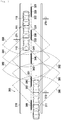
- a vehicle 110 is driving on a road 300.
- the road has the right limit 310 and the left limit 311 which may be marked by limit lines, a kerb or any other limitation or marking means.
- a centreline which is a dashed line in this embodiment, having a plurality of dashes 320, 330, 340, 350 and 360.
- Each dash has a beginning and an end. The beginnings are marked 321, 331, 341, and 351 whereas the ends are marked 322, 332, 342 and 352.
- road furniture which may be traffic signs 370, 371, 372. From the captured ambient data set the vehicle preferably identifies the above mentioned road objects and most preferably generates respective second data sets.
- an ambient data set may give a 360 degree representation of the vehicle's environment
- a viewing sector 380 which may correspond to a front camera, having an approximately 90° viewing angle.
- the corresponding front image is shown in figure 6a .
- the left side of the image shows centreline dash 330 and part of the following centreline dash 340. It is obvious, that this view gives a clear image of the road objects related to the right lane of the road, where the vehicle is driving, but cannot provide too much information about the road objects at the left lane from which parts can be seen in the left top corner of the image.
- the vehicle proceeds along the road through positions 111 and 112, it captures images according to the image sectors 381 and 382.
- the corresponding images together with the identified road objects are shown in figures 6b and 6c .
- a first set of ambient data 380, 381 and 382 is captured by a first vehicle propagating in a first direction on the right lane which is from the right to the left on the top lane in this figure, and converted to driving-relevant object data sets.
- a second set of ambient data is captured by a second vehicle propagating in the opposite direction on the left lane which is from the left to the right on the bottom lane in this figure, and converted to driving-relevant object data sets.
- the driving-relevant object data sets generated by the second vehicle may be similar as shown in figures 6a, 6b and 6c . The main difference is that the driving-relevant object data sets now mainly contain the road objects at the second lane and therefore provide information about the second lane.
- the server database may fit together the information provided by the vehicles to get the full set of all road objects provided so far.
- the vehicles generate object-based information about the individual road objects like right limit 310, left limit 311, centreline dashes 320, 330, 340, 350, 360 and traffic signs 370, 371, 372.
- This object-based information is collected and evaluated by the server database to generate a full driving-relevant object data set of the road in the second object data processing step of the two-step processing for generating and updating a precision road property database.
- This example is not limited to two vehicles, but may be extended to any number of vehicles.
- the object-based information relating to the first ambient data set as shown in figure 6a may be provided by a first vehicle
- the object-based information relating to the second ambient data set of figure 6b may be provided by a second vehicle, passing the same road at a later time
- the third ambient data set of figure 6c may be captured by a third vehicle, again passing the same road later.
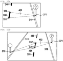
- FIG 8 an example of grouping of objects is shown.
- Grouping of objects may be used to provide a simplified and better matching of adjacent ambient data sets by the vehicle or of driving-relevant object data sets by the vehicle or by the server database.
- a vehicle may use grouping for the first object data processing step.
- the server database uses grouping for the second object data processing step.
- a first group 401 comprises centreline dash 350 and traffic sign 372.
- a second group 402 comprises the centreline dash 330 and the traffic sign 370 as well as the traffic sign 371 at the opposite side of the road.
- the traffic sign 372 would only be at the outmost corner of the corresponding driving-relevant object data set of the vehicle driving in the opposite direction, but the corresponding centreline dash may also be well identified by the vehicle driving in the opposite direction. This is further shown in more detail in the next figures.
- FIG. 9a shows the view from a vehicle at the bottom lane of figure 5 passing from the left to the right.
- the traffic sign 372 is well visible and can easily be grouped together with centreline dash 350 to form a first group of objects 401.
- the traffic sign is in the main field of view, its position can be determined precisely.
- the relative position of centreline dash 350 can also be determined precisely.
- Figure 9b shows the view from a vehicle on the top lane passing from the right to the left. Traffic sign 372 is only at the outmost corner of the image and far away.
- this matching may be used for precision position determination.
- the vehicle driving from right to left in figure 5 cannot use traffic sign 372 as it is in the outmost periphery of its view.
- By identifying the centreline dash 350 of the first group of objects 401 a comparatively precise location can be done. Based on the information determined by a vehicle previously driving from left to right, the vehicle driving in the opposite direction knows the precise location of centreline dash 350 which is associated with traffic sign 372.
- Figures 10a and 10b show a second example of matching by grouping objects.
- a second group 402 of objects comprising the centreline dash 330 and the traffic sign 371 is shown.
- the contour of this group is defined by the first end 331 and the second end 332 of the centreline dash 330 together with the base of traffic sign 370 and the base of traffic sign 371.
- a first driving-relevant object data set generated by a vehicle driving the road of figure 5 from right to left on the top lane is shown.
- only part of the group 402 is shown.
- a different driving-relevant object data set taken by a different vehicle and/or by a different camera is shown.
- This driving-relevant object data set has been captured with image sensors with a larger viewing angle and therefore also shows traffic sign 370.
- all the members of the second group 402 of objects are shown.
- At least the first section of group 402 comprising centreline dash 330 and traffic sign 371 can be correlated with the previous driving-relevant object data set.
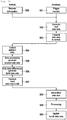
- FIG 11 the basic flow of data collection, distribution and processing is shown. Specifically the combination of the first object data processing step 555 in the vehicle and the second object data processing step 559 in the server database result in data sets having a high accuracy and precise position information.
- a precision road property database comprising driving-relevant objects is updated by using a vehicle which is communicating with the server database.
- the figure has two columns. The left column shows the actions related to the vehicle, while the right column shows actions related to the server database.
- the server database preferably stores driving-relevant object data.
- driving-relevant object data may further comprise at least location information and detailed object-based information about at least one of a road object, a road furniture object, a geographic object and a further object related to driving.
- the vehicle requests information 550 from the server database, for example based on a planned route or an area of interest.
- the server database may trigger a transfer 551, for example for updating specific information.
- the server database After such a request or trigger, the server database generates 552 at least one first data set which is related to the request or trigger. These first data sets are based on fourth data sets stored in the server database.
- each first data set comprises driving-relevant object data.
- the server database has stored information about the status of the vehicle database. Such information may comprise a copy of the data sets stored in the vehicle or at least one identifier for identifying data sets stored in the vehicle. This status information is preferably updated after the vehicle has confirmed reception of first data sets.
- the first data set may only comprise amended data sets and/or new data sets. There may be data sets which the vehicle does not have, data sets, which the vehicle has, but which are updated, data sets, which the vehicle has, but which are retransmitted, or data sets which the vehicle should delete. Therefore, if requested by the vehicle, the at least one first data set may contain data about the required coverage. If triggered by the server database, the at least one first data set may contain updated data and/or warning data and/or data which should be verified by the vehicle. It is preferred, if each first data set comprises at least one location information and detailed object-based information. The location information specifies a position, an area or region to which the detailed object based information is applicable.
- the first data sets are forwarded to the vehicle 553 and stored in the vehicle database.
- the vehicle collects ambient data 554 by at least one sensor as described above. This collection may take place along at least a specific section of its path and/or at a specific time and/or a specific object.
- the ambient data sets are relating to at least one of driving-relevant objects, road furniture and geographic objects.
- Such ambient data is processed in the first object data processing step 555 to generate second data sets comprising object-based information. This processing may include statistical evaluation based on the ambient data and/or at least one of the first data sets. It may further include grouping, matching and transformation of data as described above.
- the differences between the third and first data sets are calculated to generate third data sets containing differences between the object-based information of the second data sets and the object-based information of the first data sets related to the section of the vehicle path.
- at least one third data set may comprise object-based information of at least one second data set instead of a difference to a first data set. If necessary and/or requested by the server database, such third data sets may also contain new data and/or data independently of existing first data sets.
- the third data sets are forwarded to the server database.
- the server database stores the received third data sets 558 and starts processing them in the second object data processing step 559.
- Such processing preferably comprises statistical evaluation and further post processing of the third data sets.
- the fourth data sets stored in the server database may be used.
- Such post processing may include object grouping, object matching, group matching, transformation, statistical calculations, and other processes. Later, the fourth data sets may be updated 560 by using the results thereof.
- step 570 the vehicle identifies a first plurality of vehicle path sections relating to the same part of the road and at least partially overlapping each other based on at least one second data set. Then, in step 571, a plurality of object reference points is identified in each vehicle path section.
- a reference point preferably is a point which can easily and precisely be identified.
- the reference points are grouped in step 572 such, that in at least two of the vehicle path sections of the first plurality of vehicle path sections, each group comprises the same object reference points.
- alignment functions for matching and/or aligning the at least one group of object reference points in at least two of the vehicle path sections of the first plurality of vehicle path sections relating to the same part of the road are generated or calculated in step 573.
- Such an alignment function may comprise any of a linear translation and/or a rotation or even a more complex transformation.
- the same alignment functions are applied in step 574 to all other second data sets of the same at least two vehicle path sections for generating or updating fourth data sets containing driving-relevant object data.
- the second data sets may be statistically processed by preferably calculating average values and/or standard deviations of the third or second data sets.
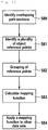
- step 13 a detailed flow diagram of precision alignment of vehicle path data related to the same part of the road by the server database as part of step 559 is shown.
- the server database identifies a first plurality of vehicle path sections relating to the same part of the road and at least partially overlapping each other based on at least one third data set.
- a plurality of object reference points is identified in each vehicle path section.
- a reference point preferably is a point which can easily and precisely be identified.
- the reference points are grouped in step 582 such, that in at least two of the vehicle path sections of the first plurality of vehicle path sections, each group comprises the same object reference points.
- alignment functions for matching and/or aligning the at least one group of object reference points in at least two of the vehicle path sections of the first plurality of vehicle path sections relating to the same part of the road are generated or calculated in step 583.
- Such an alignment function may comprise any of a linear translation and/or a rotation or even a more complex transformation.
- the same alignment functions are applied in step 584 to all other third data sets of the same at least two vehicle path sections for generating or updating fourth data sets containing driving-relevant object data.
- the third data sets may be statistically processed by preferably calculating average values and/or standard deviations of the fourth or third data sets.
- FIG 14 a detailed flow diagram of precision positioning is shown.
- Precision positioning of a vehicle is done by using data from a database and data collected by the vehicle when traveling along a path.
- the vehicle receives first data sets from the database, which are based on fourth data sets comprising driving-relevant object data.
- driving-relevant object data may comprise at least location information, an optional object reference point and detailed object-based information about at least one driving-relevant object like a road object, a road furniture object, a geographic object or a further object related to driving.
- the vehicle When driving, in step 591, the vehicle generates a plurality of ambient data sets along at least sections of its path by at least one sensor of the vehicle.
- the ambient data sets relate to at least one of driving-relevant objects, road furniture and geographic objects.
- the vehicle performs object data processing by evaluating the at least one ambient data sets and generates at least one second data set of driving-relevant object data based on the evaluation results.
- the vehicle tries to identify in the second data sets the same driving-relevant objects and/or object reference points and/or groups of driving-relevant objects and/or object reference points as are contained in the first data sets.
- step 594 the vehicle aligns the same driving-relevant objects and/or object reference points and/or groups of driving-relevant objects and/or object reference points between the second data sets and the first data sets, and calculates or derives a position value for its own position in step 595.
- Figure 15 shows the basic 2-Phase method of building up a road database while reducing the overall image processing load in a vehicle and extending the usage range of highly automated driving (HAD) and other vehicle control applications.
- a vehicle has received first data sets in step 600.
- the comparison step 601 the confidence level of individual first data sets is compared with a limit value. If the confidence level exceeds the limit value, the second phase, phase 2 is initiated for the first data set. Else phase 1 starts with said first data set.
- FIG 16 shows Phase 1 in more detail.
- further ambient data is collected in step 610 as may be shown in more detail in figure 4 .
- off-line data processing is started in step 611, using the ambient data.
- processing may be done on-line if sufficient processing power is available.
- a processing option is selected. Such processing options have been disclosed in more detail above and may comprise:
- Close-up 614 Selecting an ambient data set which is close to the object of interest, in each ambient data set.
- Moving back and forth 615 Moving back and forth through the ambient data sets in order to determine objects of interest from a close distance or from different viewing angles and distances.
- Sequence 616 Running a sequence of ambient data sets in series through different sets of algorithms.
- third data sets are generated in step 618.
- FIG 17 shows Phase 2 in more detail.
- ambient data are collected in step 620.
- step 621 the method of generation of driving-relevant objects for the second data sets is selected.
- Steps 620 and 621 may be exchanged in their order. So either the method may be selected on the kind of ambient data or other parameters or the data may be collected as required by the method.
- the decision on the method is mainly based on the type of first data sets. If the first data sets comprise object descriptions of the driving-relevant objects of the empty road, the first method is selected. If the first data sets comprise a vector graphics format, which allows rendering as an image in different ways and from different viewing angles, the second method is selected.
- method 1 the object descriptions of the first data sets are processed. If method 2 has been selected, a comparison on image level is made. Details of this method are disclosed above. By using either method, second data sets are generated 624 based on first data sets. Furthermore, both methods may be used for the same data sets.
- the first data sets may be probed and confirmed by the vehicle. Differences may be reported via third data sets.
- the selection of the method may be made starting to collect ambient data. In such a case the selector 621 is not required.
- Figure 18 shows an image of an exemplary road having a plurality of driving relevant objects.
- Figure 19 shows the driving relevant object in the previous image.
- roads 701 - 704 street markings 710 - 717, traffic lights 720 and 721 and traffic signs 730 - 733.
- First data sets which may be stored in a vehicle preferably comprise driving-relevant object data.
- driving-relevant object data may further comprise at least location information, an optional object reference point and detailed object-based information about at least one driving-relevant object like a road object, a road furniture object, a geographic object or a further object related to driving and data comprising a vector graphics format, which allows rendering as an image.
- a first data set may further comprise confidence level information.
- Figure 20 shows an image rendered from objects related to driving and data comprising a vector graphics format of the first data sets preferably relating to the objects of the previous figure.
- Such rendered images may be used for generating information for vehicle control and/or information for vehicle positioning and/or second data sets for generating and updating first data sets by comparing the at least one ambient data set on an image level to an image or partial image.
- the ambient data sets may have been previously collected along its path by at least one sensor of the vehicle, the ambient data sets preferably relate to at least one of driving-relevant objects, road furniture and geographic objects.
- the information may be generated by comparing the at least one ambient data set with the object descriptions of the at least one first data set comprising object descriptions of the driving-relevant objects of the empty road.
Description
- The invention relates to a method and a system for collecting road data and environmental data of the vicinity of a road. There is a two-step object data generation and processing shared between a vehicle and a server database for generating data sets comprising driving-relevant object data. It further relates to a database containing such data, a method for building such a database and a method for distributing such data to vehicles.
- For enhancing the operation of vehicles and for providing new features and functions an increasing number of sensors and processors or computers are integrated in modern vehicles. In
US 6,353,785 B1 , a method and system for in-vehicle computer architecture is disclosed. The computing architecture includes a data network comprised of a plurality of interconnected processors, a first group of sensors responsive to environmental conditions around the vehicle, a second group of sensors responsive to the vehicle's hardware systems, and a map database containing data that represent geographic features in the geographic area around the vehicle. The vehicle operations programming applications may include adaptive cruise control, automated mayday, and obstacle and collision warning systems, among others. In this embodiment, the vehicle needs a continuous communication over a data network which may sometimes be interrupted under real road conditions. Furthermore, a precise map database is required. -
US 2012/135745 A1 discloses a system for generating and updating digital map data using a backend server ("map developer") and a mobile device, which mobile device captures images of an environment. D1 is notably concerned with various ways of distributing the processing of the images amongst the mobile device and the "map developer". -
US 2007/124064 A1 discloses a map information updating system with a central apparatus and multiple terminal apparatuses, in which system map information to be updated must be confirmed by different information sources. Manual inputs are required at the terminal apparatuses for adding data related to an object. -
US 2010/014712 A1 discloses a method for updating a geographic database based on comparing images captured at a location with photorealistic images for that location stored in a database. When a vehicle is driving on a new road that is not represented in the database it either checks with a server if an update for the vehicle's database is available or provides data pertaining to the new road to the server. - Jaejun Yoo et al., in "Vehicular image based geographic information system for telematics environments - integrating map world into real world", Geoscience and Remote Sensing Symposium, Seoul, Korea, 25-29 July 2005, IGARSS '05 PROCEEDINGS, vol. 2, pp. 1206-1209, disclose a system for mapping vehicular images to geographic information, in which spatial attributes captured by cameras are assigned to ground coordinate values in geographic data.
-
EP 1 219 928 A1 - To generate road maps, highly specialized vehicles are used. They have expensive equipment for scanning roads which may cost significantly more than the vehicle itself. After scanning the roads, manual processing of the acquired information is required. This is expensive, labour intensive and prone to errors. Therefore, only comparatively long update cycles can be achieved.
- The problem to be solved by the invention is to improve the known vehicles, databases and methods for building databases which further provide sufficient information to vehicles to enable Highly Automated Driving (HAD), or autonomous driving, or self-driving, or other vehicle control applications, or precision vehicle positioning.
- Solutions of the problem are described in the independent claims. The dependent claims relate to further improvements of the invention.
- Tests and simulations with HAD and self-driving vehicles have shown that a very detailed knowledge of the vehicle's environment and specifically of the road is required. Such data may be used for a plurality of other applications like high-beam assist, speed advisor, bump/pothole warning, economic driving, smart cruise control, advanced shifting, accelerator force feedback pedal, smart energy management, damping control, advanced retarder control, cooling strategy, emergency steering assist, preview ESC, intelligent parking, traffic light assist and curve speed warning. Therefore, it is desirable to provide fresh and up-to date data of the road and other driving-relevant objects at moderate or low cost.
- Such data is preferably based on data acquired by sensors in the vehicle. But it would be desirable to have road information beyond the reach of the sensors, for example in a long distance or behind a curve. Such information may allow a proactive control of the vehicle. If for example, the vehicle is approaching an intersection behind a curve, the speed of the vehicle may be reduced, or a different gear may be selected prior to an inclining road.
- Furthermore, such sensors may be impaired by internal errors or by environmental conditions. For example, a camera tracking the road, may be impaired by fog or heavy rain. In such a case, it would be desirable to have detailed information about the road which allows to correlate the captured camera image with the known information. This way it may be possible to interpret information in a correct way, which otherwise would be hard to recognize. If, for example, the vehicle knows precisely the positions of each dash of a dashed centreline and its exact distance to the border of the road, a positioning may still be possible, even if the camera image is extremely noisy and the centreline dashes are hard to detect.
- If sufficiently detailed, fresh and reliable information about the road and other driving-relevant objects is available, the field of use of the above mentioned vehicle applications may be broadened or the requirements on the vehicles' sensors may be lowered and vehicles may be equipped with less or cheaper sensors. Furthermore, driving may be possible with failed or impaired sensors.
- Conventional digital maps of the road, which are used today in conjunction with GNSS tracking of vehicle movements may be sufficient for navigation, but they are not detailed enough for self-driving vehicles. Scanning the roads with specialized scanning vehicles provides much more details, but is extremely complex, time-consuming and expensive. Therefore, there are large update intervals which may reach an order of years. From a global view, the road infrastructure itself does not change quickly, as road construction is expensive and time-consuming. A road between any two points will remain for a long period, but road details may change quickly. Therefore, it is desired to provide sufficiently detailed and precise road information or road property data in a timely manner.
- The basic concept of a preferred embodiment of generating and updating a precision road property database is a two-step object data processing, whereby a first object data processing step is done by a vehicle and a second object data processing step is done by a server database.
- In a first embodiment, a standard production vehicle uses its sensors to collect a plurality of ambient data sets, processes them and communicates with a precision road property database on a server to improve the quality of its collected data and to provide the server database updated ambient information. Generally, the information is mostly object-based and related to driving-relevant objects like a road object, a road furniture object, a geographic object or a further object. A road object preferably is related to a road itself. It may describe basic characteristics of a road like the width, the direction, the curvature, the number of lanes in each direction, the width of lanes, the surface structure. It may further describe specific details like a kerb stone, a centreline, even a single dash of a dashed centreline or other markings like a crosswalk or a stop line. A road furniture object is related to road furniture, also called street furniture. Road furniture may comprise objects and pieces of equipment installed on streets and roads for various purposes. It may include benches, traffic barriers, bollards, post boxes, phone boxes, streetlamps, traffic lights, traffic signs, bus stops, tram stops, taxi stands, public sculptures, and waste receptacles. A geographic object may be any stationary object like but not limited to a building, a river, a lake or a mountain. Further objects may be objects which are not falling into one of the above categories, but are also relevant for driving. Such objects may be trees, stones, walls or other obstacles close to a road. They may also comprise structures like trenches, plane surfaces and others which may be considered for planning alternate, emergency exit or collision avoidance paths.
- The vehicle may be a car, a truck, a motorbike or any other means for traveling on a road along a path. The embodiments are described herein by example of a vehicle, but they are generally applicable to a plurality of vehicles. A vehicle preferably has a number of sensors like, but not limited to a camera system like a CCD camera which may be suitable for capturing visible and/or infrared images. Preferably a simple mono- camera is provided. Alternatively, a stereo camera, which may have two imaging sensors mounted distant from each other may be used. There may be further sensors like radar sensors, laser sensors, infrared sensors, ultrasound transducers or other environmental sensors. Although it is preferred, that the sensors are oriented to the driving direction, they may be oriented to other directions like sideward or to the rear of the vehicle. It is further preferred, if the vehicle has at least one computer or a plurality of computers, together with memory and software for performing the methods described herein. Most preferably a computer has enough processing power and memory for processing the sensor signals. Furthermore, it is preferred, if the vehicle has communication means for communicating over a communication network which may be, for example but is not limited to, a mobile communications network, Wi-Fi, satellite radio or any other type of network, which may even be a cable network. In general, communication between the vehicle and the server database is established by such communication means. The vehicle may use different communication means dependent on availability or cost, like a mobile communications network on route and Wi-Fi close to hotspots or at home.
- The precision road property database further referred to as server database if not otherwise mentioned, preferably is provided by a service provider and preferably is hosted on a plurality of host computer systems. It may be a central database, but preferably it is split into a plurality of sub databases, which for example are divided by geographic regions. Preferably, a database manager is connected to the server database. Most preferably, the database manager comprises a plurality of sub- managers connected to sub databases. Preferably, the server database has a suitable network connection like an Internet connection to communicate with the vehicle. In an alternate embodiment, the communication with the vehicles may be performed via third party communication systems like back ends of vehicle manufacturers. The bandwidth should be large enough to communicate with a large number of vehicles simultaneously. It is preferred, if the communication is compressed and/or encrypted. Preferably, the server database comprises a physical data storage which may be in specific server locations, in a cloud based shared infrastructure, a combination of approaches or similar embodiment, together with a software for managing data storage and data flow. Herein, the term server database is used meaning all related systems in a broad sense. This may include a computer system, a physical storage or a cloud based shared infrastructure, a database engine, a database manager and further software for processing data in the database or similar embodiment.
- Preferably, the vehicle gets road property data before driving autonomously and stores it in a vehicle database. An initial data set may be supplied by a vehicle manufacturer during a manufacturing or initial initialization procedure of the vehicle, by a data storage medium like a CD, DVD, hard disk, portable memory, or by download from the server database. As the initial data set may be comparatively large, it is preferred to have a high-speed data connection available for an initial download from the server database. It is preferred, if the initial data set covers an area or region in which the vehicle may operate in the near future. After the initial data set has been received, the vehicle may require further updates. Such updates may provide new information about changed objects and/or an extension or change of the previously covered area. The vehicle may request such updates from the server database in certain intervals and/or if a high speed network connection is available and/or if an extension of coverage is required, which may be the case after a new route has been planned or even during driving. The server database may also trigger a data transfer to the vehicle based on its knowledge, which data may be required by the vehicle. Such data preferably is updated and/or urgent data which may include warnings of dangerous road conditions.
- For providing initial or ongoing data sets to a vehicle, the server database generates at least one first data set from fourth data sets stored in the server database. The at least one first data set is related to the request by the vehicle or the trigger by the server database. Preferably, the first data set covers an area of interest for the vehicle. Such an area of interest may be modified by the server database or the vehicle over the time of the vehicle's use. Preferably, the path driven by the vehicle is part of its area of interest. It is preferred, if the server database has stored information about the status of the vehicle database. Such information may comprise a copy of the first data sets stored in the vehicle or at least one identifier for identifying the first data sets stored in the vehicle. This status information is preferably updated after the vehicle has confirmed reception of first data sets. By using this status information, the first data set may only comprise amended data sets and/or new data sets. There may be data sets which the vehicle does not have, data sets, which the vehicle has, but which are updated, data sets, which the vehicle has, but which are retransmitted, or data sets which the server database wants the vehicle to delete. If triggered by the server database, the at least one first data set may contain updated data and/or warning data and/or data which should be verified by the vehicle. It is preferred, if each first data set comprises at least one location information and detailed object-based information. The location information specifies a position, an area or region to which the detailed object based information is applicable. This includes, that a data set may comprise one location information and a plurality of object-based information which preferably relate to the same or adjacent locations. The object based information may comprise detailed information about at least one driving-relevant object like a road object, a road furniture object and a geographic object.
- Preferably, the data sets provided by the server database to vehicles and from vehicles to the server database comprise an object-based 3D vector format. Most preferably, the first, second, third and fourth data sets comprise such a vector format. Such a vector format may be a vector graphics format, preferably like a standard vector graphics format as used in computer game or CAD drawing technologies or a derivative thereof. It is preferred, if detailed objects of a road like limits of the road, markings of the road, intersections and exits as well as street furniture are represented in a 3D vector graphics format. Due to a vector graphics format, only low volumes of data have to be transferred between a vehicle and a server database and back. Also, a vector graphics format allows to render the road property data in different ways, to represent different viewing angles or sensor styles such as camera-like or radar-like.
- It is preferred, if the server database supplies auxiliary information to the vehicle as part of the first data sets. Such auxiliary information may be a server database generated confidence level or other confidence related information, herein called confidence level, and importance level, and urgency level or statistical information like average values and standard deviations. This auxiliary information may be supplied for each individual data set or for a group of data sets.
- After the first data sets have been generated, they are forwarded to the vehicle and stored in the vehicle database. From the vehicle database, the vehicle can derive driving-relevant data for its driving control applications like highly automated driving.
- But vehicles are not only consumers of road property data. They also generate road property data by analysing ambient data sets collected by their sensors. Under normal road and driving conditions, it may be preferred, if vehicles sample or collect information by their sensors, preferably also by their image sensors while driving, while participating in traffic or at least while being on the road or in proximity to a road and compare and/or correlate the sampled information with the previously downloaded or stored information on a regular or periodic base. The frequency or time intervals between such collections, which may also be called sampling rate, may be determined by the sensors in the vehicle, their resolution and/or the processing power in the vehicle. Instead of periodic sampling, random sampling may be chosen. The frequency of sampling may also be adapted to the environment. In the case of a curvy road, a higher sampling rate may be desired compared to a straight road. Different sapling rates may also be requested by the server database.
- The sampled ambient data sets may be recorded and stored over a certain time as a sequence of ambient data sets. This allows to process the stored ambient data sets as a background task and to move back and forth through the stored data sets for more sophisticated processing in contrast to real-time processing which has to follow the vehicle at speed. Storage of a sequence of sampled ambient data sets allows the vehicle specifically when driving, to monitor for the objects appearance over time and/or distance. For example, a traffic sign may be a small spot on an image taken by a camera from a large distance. When approaching the traffic sign, this spot increases and starts to show a characteristic pattern until it can be seen clearly in a close up view shortly before passing the traffic sign.
- A continuous recording of ambient data sets at least over a certain time interval may also allow a view-back. In the above example, the vehicle may have identified the traffic sign just before passing the traffic sign. It is now possible to roll back the ambient data sets, such as images, when approaching the traffic sign and to generate further information how such a traffic sign looks like from a distant approach or where it is exactly located. This data may also be used as part of the driving-relevant data to enable vehicles to detect the traffic sign from a larger distance.
- The server database may transmit a sampling request message, which preferably specifies the time and/or location of which information should be sampled. Furthermore, the server database may request a special processing of a specific object or area. For example, it may request text or language processing of a traffic sign. It may further request a high resolution image of an unknown area, for example a traffic sign, such that the server database itself may do additional processing such as text recognition in a foreign language. Special requests may preferably be addressed to specific vehicles which may have specific equipment for example like a stereo camera or a laser scanner or which move in a certain region. The server database may also upload specific processing instructions or specific program code. Such special processing requests may be contained within at least one first data set, either as implicit instructions or by means of parameters or data. For example, a low confidence level would trigger a rescan of an object to get better information and therefore to increase the confidence level.
- Sampling may also be triggered based on confidence and/or importance and/or urgency levels. If a first data set in the vehicle database shows a comparatively low confidence level or a high importance and/or urgency level at a certain location, it would be preferred, if a large number or almost all vehicles passing or staying at that location would collect information by their sensors and forward updates to the server database. Over time, an increasing number of data is collected which leads to a higher confidence level. As it may not be necessary to rescan objects with a higher confidence level, the number of rescanned objects decreases with time. Accordingly, the network traffic and the required processing power in the vehicle and the server database may decrease.
- Furthermore, there may be a priority scheme to better utilize less-expensive communication networks if a high number of vehicles are transmitting updates at the same time. If for example, the confidence level of a data set is comparatively low and the sensors deliver improved data, the vehicle may record such data. If the confidence level is very high, only a low number of differences may be recorded. In such a case, the server database may further increase the confidence level. If the data already has a maximum confidence level, the vehicle will not record further data in that area. Instead it may generate at least one confirmation data set or send a confirmation message to the server database about passing a certain road section without having identified any differences. This way, the communication volume and thus communication cost may decrease with growing confidence in the data.
- The processing power in some vehicles may not be sufficient to do a real-time comparison of data provided by the vehicle database and the data acquired by the vehicle's sensors for the complete vehicle path driven, at least with high frame rates, which may be adequate for high speed driving vehicles. A vehicle, which is driving at 120 km/h proceeds with 33.3 m/s. To get a spatial resolution of a sequence of ambient data sets of about 1m, 33.3 ambient data sets must be processed per second. Comparing the vehicle database information with the ambient data sets in parallel to other driving-related tasks, may overburden most vehicle's computers, in particular as a single ambient data set may comprise a large number of information of a plurality of sensors like cameras, radar sensors, infrared or RF sensors and more, like other environmental sensors. Therefore, the comparison is preferably done in larger, discontinuous sections of the vehicle's path, as can be handled by each vehicle. The length of the vehicle path sections may be in a range from a few metres to some hundred metres and follow each other with a gap of a few metres to some hundred metres, which may further depend on a vehicle's speed or the currently available processing power. In a further embodiment, the evaluation of different information may be made independently. For example, visible camera images may be evaluated in real time, while laser scanned images may be evaluated at a later time. In a further embodiment, a certain level of evaluation of information may be done close to real-time, following the vehicle at speed, while a more detailed evaluation of information may only be done if differences are detected.
- All or at least a selection as mentioned above of the road ambient data sets collected by the sensors are further evaluated to generate at least one second data set by the vehicle, each second data set comprising at least location information and detailed object-based information about at least one of a road object, a road furniture object and a geographic object. To generate such second data sets, the stored ambient data sets are evaluated. Preferably, the vehicle identifies driving-relevant objects either by the stored ambient data sets alone or by correlation of the stored ambient data sets with the information from at least one first data set as stored in the vehicle database. Such a correlation may be useful, if an object is hard to identify, which may for example be caused by a poor viewing angle, poor weather conditions or if the object is at least partially hidden. It is preferred, if the vehicle uses advanced techniques for increasing the object description accuracy like statistical evaluation or grouping of objects which will be described later in more detail. The second data sets represent the current view of the driving-relevant objects by the vehicle. Generating at least one second data set and/or generating at least one third data set is the first object data processing step which is done by the vehicle.
- After generating the second data sets, the vehicle generates third data sets containing differences between the object-based information of the second data sets and the object-based information of the first data sets as stored in the vehicle database. Additionally or instead, at least one third data set may comprise a second data set without a calculated difference. Furthermore, third data sets may contain partial ambient data sets, complete ambient data sets, sequences of ambient data sets and other auxiliary information from sensors and the vehicle status as well as intermediate processing results. Preferably, the area of coverage of the third data sets is limited as requested by the server database or as determined by the vehicle. This selection has been described above in detail. It is further preferred to generate only such third data sets, when there are at least a minimum of differences between the object-based information of the second data sets and the object-based information of the first data sets, except such data sets have been expressly requested by the server database. As an alternative to not generating certain data sets, the data sets may still be generated but marked that no transmission to the server database should be made. If the vehicle has identified important data and generated at least one second data set without a corresponding first data set, it may be assumed, that the vehicle has identified a new object. Preferably, third data sets are always generated for such new objects. The third data sets may contain auxiliary data which may give further information like a vehicle generated confidence level. Such a vehicle generated confidence level may be determined by the vehicle based on the equipment of the vehicle, traveling speed, number of measurements or images or on a signal to noise ratio or any other measurement parameter. There may be further parameters to influence the vehicle generated confidence level like weather conditions, visibility conditions, light conditions, shadow, blinding and others.
- Finally, the vehicle forwards the third data sets to the server database. Communication with the server database may be done according to the availability of a communication network. So communication may, for example, be done when a vehicle is parked or stops at a traffic light and Wi-Fi is available. Important and/or urgent data may always be exchanged via a mobile communications network, while other data may be exchanged at a later time when Wi-Fi is available. As the third data sets mainly comprise object data of driving-relevant objects, they are comparatively compact and require less size than images taken from the road or the objects. This significantly simplifies communication and reduces network load. Only in very special cases, larger image data may be transferred to the server database. For example, if a traffic sign is not readable, an image of this traffic sign may be forwarded to the server database for further evaluation.
- The steps mentioned above may either be performed in sequence, processing a certain quantity of data sets step by step or by processing individual data sets. For example, data of a certain section of the vehicle's path may be collected and processed step by step after the path section has been passed by the vehicle. Instead, data processing may be made continuously while the vehicle is passing a certain section of its path. Furthermore, data may be continuously forwarded to the server database or in bursts. Also a combination may be possible. For example there may be a continuous real-time processing when the vehicle is passing a certain section of its path, while recording all relevant sensor data, allowing a view back as described above, if the vehicle detects an important object.
- Preferably, a selection of the received third data sets are stored by the server database. Alternatively, all received third data sets are stored by the server database. Preferably, there is a large number of third data sets for each road stored in the server database. This may be like a history showing the results of previous third data sets from different vehicles for the road. The server database has at least fourth and third data sets available for further evaluation. The server database or a database manager which may be part thereof may review the third data sets received from the vehicles about differences to the fourth data sets. The server database tries to fit the third data sets to the fourth data sets. Normally, the location information of the objects of third data sets should be in close proximity to the fourth data sets. There may be a deviation in an order of the maximum GNSS tolerance defining a maximum tolerance window. Therefore, the server database only has to compare data sets within this maximum tolerance window. This processing performed by the server database is the second object data processing step for generating and updating a precision road property database. It may further be complemented by the following steps and methods.
- The database preferably generates an object reference point for objects. Such object reference points may later be used for aligning objects or groups of objects. The object reference point preferably is assigned to a part or feature of an object, which may be identified easily and with comparatively high precision. It may for example be the geometric centre of a traffic sign or a specific light of a traffic light.
- Preferably, the server database makes a statistical evaluation of the information received from the vehicles. If a significant number of vehicles report the same differences, there is a certain probability, that the real road has changed compared to the server database. Therefore, the server database may be updated.
- A very important aspect is improving the object description accuracy of the third data sets when generating the fourth data sets. For example the object modelling in the third data sets as done by the vehicles might not be optimal for the fourth data sets and may be changed by the server database when the fourth data sets are generated. Also, GNSS position information is prone to errors, not all of which have a normal distribution, which could be dealt with by averaging. For example, a first number of third data sets originating from a first vehicle may have a certain position offset over a second number of third data sets originating from a second vehicle. Or, remaining errors in the third data sets, resulting from a lack of calibration and normalisation of the vehicle sensors, such as optical distortions, need to be dealt with. In order to improve the object description accuracy, the information, and especially the position information of a plurality of data sets, preferably third data sets, may be evaluated and/or aligned.
- A preferred embodiment relates to a method of precision aligning of vehicle path data as follows to improve the collected data by matching and aligning certain collections of data related to the same part of the road. Preferably, the server database receives third data sets from a plurality of vehicles which are based on at least one ambient data set related to each of the sections of the vehicle path, which the vehicle decides to report. Such ambient data sets preferably relate to at least one of driving-relevant objects, road furniture and geographic objects. For generating such third data sets, object data processing is performed in the vehicle by evaluating the at least one ambient data sets and generating at least one second data set of driving-relevant object data based on the evaluation result and/or partial ambient data and/or intermediate processing results, and by comparing the at least one second data set of driving-relevant object data with at least one first data set of driving-relevant object data as stored in the vehicle database.
- The server database identifies a first plurality of vehicle path sections related to a part of the road at least partially overlapping each other, each based on at least one third data set. There may be a preselection of such data sets based on location information about the data set, which may be a GNSS position information. This is followed by a first coarse alignment step of the third data sets in the first plurality of vehicle path sections relating to the same part of the road based on the location information contained in the at least one third data sets in each vehicle path section. For precision alignment, a plurality of object reference points and/or the related objects is identified in at least two vehicle path section. The reference points are and/or the related objects are grouped such, that at least two vehicle path sections of the first plurality of the vehicle path sections comprise at least one of the same group of object reference points and/or the related objects. Finally, alignment functions for matching and/or aligning the at least one group of object reference points and/or the related objects in the at least two vehicle path sections of the first plurality of vehicle path sections relating to the same part of the road are generated or calculated. The same alignment functions are applied to at least a selection of the other third data sets of the same at least two vehicle path sections for generating or updating fourth data sets containing driving-relevant object data. Such alignment functions may comprise any of a linear translation and/or a rotation or even a more complex transformation.
- It is further preferred, if the server database uses fourth data sets from the server database together with the third data sets as a basis for alignment.
- After generating and applying the alignment functions, the third data sets may be statistically processed by preferably calculating average values and/or standard deviations of the aligned third data sets.
- It is also preferred to do additional alignment and/or alignment by using reference points at the road intersections and/or positions known from satellite images and/or fixed geographical reference points.
- According to a further embodiment, a server database has the necessary means to perform the method of precision alignment of vehicle path data related to the same part of the road. Preferably, the method is performed by a computer having a computer program in memory.
- The same method may be performed by a vehicle to improve accuracy of the second data sets, using the first and second data sets available in the vehicle. But it is preferred to perform the precision alignment of vehicle path data related to the same part of the road within the server database instead of the vehicle, as the server database has a significantly higher processing power and further has access to a large number of data provided by a large number of vehicles.
- But even then, grouping may be performed by the vehicle for another purpose. Grouping of object reference points and/or the related objects may be beneficial for precise vehicle positioning. Along roads, there may be a significant number of objects with relative location references like centreline dashes. As there are many dashes which essentially look alike, it would be difficult to distinguish between the individual dashes and to get an absolute location reference longitudinally along the road. Anyway, even so, the dashes may be useful for determining the position of the vehicle orthogonally to the road, relative to the road borders. For verifying and correcting GNSS position information and/or for precise positioning of the vehicle relative to the objects of the road and also longitudinally along the road, further position references are required. Such position references may be unique objects or objects which rarely occur. Such references may be traffic signs or special marks on or besides the road. But special objects might not occur very often and not often enough for precise and continuous vehicle positioning. Therefore it is further preferred, if a plurality of objects is grouped together. Even if the individual types of objects in the group may have many occurrences along the road and are not very distinguishable, such a group of objects, and especially the constellation it forms in 3D space may be unique for a long section of the road. An example is the constellation that two dashes form with the pole of a fence. Their position relative to each other has not been planned and therefore is very likely to be unique. Grouping of objects or object reference points allows to determine the vehicle's precise position on the road even if no really unique individual objects can be identified. The vehicle's precise position may be expressed as an offset to the position provided by a GNSS system. It may further be expressed by a position value within the position-world of the first data sets, meaning in relation to the driving-relevant objects and/or groups of driving-relevant objects as contained in the first data sets.
- The following method describes a preferred embodiment of precise vehicle positioning. Preferably, the object reference points are identified within the first data sets. While driving, the vehicle generates second data sets from collected ambient data sets. In the second data sets, the vehicle tries to identify the same objects and/or object reference points and preferably groups of objects and/or object reference points as are contained in the first data sets. A vehicle's second data sets will usually only contain a selection of the data contained in the first data sets. By aligning the same objects or object reference points of preferably groups of objects and/or object reference points between the second data sets and the first data sets, the vehicle can derive a position value for its own position and this way position itself precisely on the road.
- According to a further embodiment, the first, second, third and fourth data sets may have attached further information, for example a confidence level, providing information about the confidence or reliability of the information. If a high number of vehicles reported the same differences, the confidence level is high. If only one vehicle or a low number of vehicles reported the difference, the confidence level is low. The confidence level may also be dependent on the vehicle generated confidence level. Therefore, data sets with a higher vehicle generated confidence level may have a higher weighing factor. Another factor may be the sensor equipment grade of a vehicle. A better equipped vehicle may have a higher weight than a lower equipped vehicle when determining the confidence level. Generally, two different confidence level values like a high level and a low level may be sufficient. It may be desirable to have a higher number of confidence levels like three levels or nine levels which allow more detailed distinguishing. If a significant new information has been reported the first time by a vehicle, the confidence level may be low, but it may be an important or urgent information. The database manager therefore preferably generates at least a further tag, which may indicate the importance and/or urgency of an information. Alternatively, the confidence level may be set to a higher value to indicate a higher importance or urgency of the information. For example, a dynamically changed speed limit may be an urgent information, as a vehicle driving exceeding the limit would be subject to prosecution. Whereas a change in road marking may be less urgent, as the process of changing road markings takes hours or days, but it may also be an important information. Construction of a new building besides the road would neither be important nor urgent. But having information about the building may increase positioning accuracy. Generally, two different importance and/or urgency levels like a high level and a low level may be sufficient. It may be desirable to have a higher number of levels like three levels or nine levels which allow more detailed distinguishing.
- If the server database knows that certain changes occur often at certain locations, for example there may be frequent speed changes at a certain location due to an electronic speed display, it may assign a higher confidence level. Furthermore, it is preferred, if the vehicles also provide a vehicle generated confidence level of difference information. The server database may further alter the confidence level based on knowledge about the vehicle or the environment, like the sensor quality, for example, if it is a low resolution or a high-resolution camera, and the data quality itself. In another example, a clear image with a high-resolution camera on a clear day would provide a higher confidence level than a low resolution image during a snowstorm.
- Generally, data of further data providers like digital maps, satellite images or traffic information may be used to increase position precision of the data sets and/or to complement the data sets.
- A further embodiment relates to a method which uses the first data sets to reduce the overall image processing load in a vehicle and to extend the usage range of highly automated driving (HAD) and other vehicle control applications, for example towards bad weather conditions.
- Vehicle control applications such as HAD heavily rely on processing of image data from image sensors. Image processing requires a lot of processing power in a vehicle. Each type of image sensors typically has a limited usage range and its specific strengths and weaknesses. For example cameras provide high resolution images in colour but have a low dynamic range. They have difficulties with scenes with bright and dark areas. Cameras also don't work well in fog or rain. Radar, on the other hand, functions well under those conditions, but only provides low resolution monochrome images with reflectivity information. In order to compensate the weaknesses of the different types of sensors, various sensor types and multiple image sensors are combined in a vehicle to extend the usage range of HAD and other vehicle control applications. The need to evaluate and fuse the image data from multiple image sensors, results in a lot of processing power needed. Nonetheless, the usage range of HAD and other vehicle control applications is rather restricted because bad weather conditions still impose challenges despite expensive sensor equipment.
- As described above, the method of generating and updating the precision road database adds additional image processing needs in the vehicle in order to process the ambient data sets, to generate second data sets, to compare second data sets with first data sets and to generate third data sets which are sent to the server database. Even more processing power is added for precision vehicle positioning by comparing the ambient data sets to the first data sets. At least the latter must always work in real-time at vehicle speed.
- It is preferred, if this embodiment comprises two phases of processing and usage of data sets in vehicles. In a first phase, confidence in the fourth data sets is built up by the server database collecting third data sets of sections of the vehicles' paths and evaluating them to generate the fourth data sets which further serve as a basis for the first data sets. Already in this first phase the first data sets may be provided to vehicles by the server database and used by the vehicles in the generation of the second data sets for guiding the vehicle-side processing on the modelling approach of driving-relevant objects. But it is preferred if, in this first phase with lack of confidence in the object data, first data sets with low confidence level are not used by the vehicles for the processing of ambient data sets.
- In a second phase, at least one of the first data sets generated from fourth data sets has reached a high confidence level because a sufficient number of third data sets have been collected by the server database in order to evaluate them and generate fourth data sets with precision results and with a high level of confidence. Out of the fourth data sets, the server database generates first data sets and sends them to the vehicles. First data sets with a high confidence level may be used for the processing of ambient data sets and for vehicle control applications. The type of use may be determined by the confidence level value. For example first data sets with a very high confidence level may be used for highly automated driving in fog while this function is deactivated if the confidence level of the respective first data sets is not very high. Driving in light rain, on the other hand, where the cameras 'see' more, may still be allowed if the confidence level in the first data sets is high but not very high. The limit value may be adapted to environmental and/or driving conditions.
- In the following, the first phase and the second phase are explained in detail.
- It is preferred, if in the first phase of building up confidence, the processing load on a vehicle is limited by sampling ambient data sets for a segment of the road and by processing the resulting sequence of ambient data sets off-line, meaning not following the vehicle at its speed by leaving segments of the road out between segments of the road that are processed. This restriction is not a disadvantage for the collection of third data sets by the server database. The collection of third data sets can rely on many vehicles providing third data sets for segments of their path. It is not necessary that one vehicle provides complete information about its complete path. Each vehicle can sample and store a sequence of ambient data sets and process it off-line with as much processing power as it has and take as long as it needs for that. If that vehicle misses parts of its path in between segments of its path that it processes, these gaps will be filled by other vehicles.
- The method of generating second data sets and/or information for vehicle control and/or information for vehicle positioning and/or storing of sequences of ambient data sets and off-line processing has various options, which mostly have been described before but are summarized below. Any one or a plurality of these options may be selected to complement off-line processing:
- Zoom option: Selecting an ambient data set, which has been taken close to an object to be processed and shows it large and clear for good recognition results. More distant ambient data sets may be used for step-wise triangulation and positioning of the object relative to other objects. This results in good recognition and precise positioning results with lean processing algorithms.
- Close-up option: Selecting an ambient data set which is close to the object of interest, in each ambient data set. As only the near-field is of interest, where recognition and relative measurements work well and/or lean processing algorithms can be used.
- Moving back and forth option: Moving back and forth through the ambient data sets in order to determine objects of interest from a close distance or from different viewing angles and distances and thus with lower processing power.
- Sequence option: Running a sequence of ambient data sets in series through different sets of algorithms. It is not necessary to process and recognise all objects in parallel as real-time processing would require. This increases the possibilities for applied overall processing while reducing the requirement on processing power significantly.
- Review option: Processing backwards from the latest ambient data set into the past. In contrast to real-time processing, as for example the HAD control application does, there is no need to look forward from the latest ambient data set into its far-field and thus into the future of what will be coming towards the vehicle. Also this results in lean algorithms and low processing power needed.
- Overall, the fact that off-line processing of sequences of ambient data sets is possible in this first phase, results in good processing results with lean algorithms and a low burden on the processing power needed.
- It is also preferred if the generation of third data sets in this first phase mainly is done if the processing conditions are good, meaning at good weather and in good light conditions. Not having to generate third data sets under bad conditions, leads to being able to mainly rely on cameras only as image sensors for the ambient data sets and low processing power needed, even for good processing results. Because processing of ambient data sets can be done under good conditions and no real-time processing is needed in this first phase, the available processing power can be used for generation of third data sets with many driving-relevant objects, fully populated data and precision results as is needed in this first phase for good third data sets for segments of the vehicles' paths.
- In the second phase, at least one of the first data sets generated from fourth data sets has reached a high confidence level. There may still be further first data sets having a low confidence level. First data sets with a high confidence level just need to be probed and confirmed by vehicles passing the respective objects. It is preferred if vehicles actively confirm the data in the first data sets within the third data sets until a very high confidence level has been reached. It is preferred if the vehicles mainly report their path driven only within third data sets, once the data in the first data sets has reached a very high confidence level. By reporting their path driven without reporting a difference, the vehicles indirectly confirm the data of the first data sets along the path. This reduces communication volume. It is also preferred if the path driven information of a vehicle is neutralized such that it cannot be tracked down to the driver and raise privacy concerns. It is preferred if the server database monitors how many vehicles and when have directly or indirectly confirmed which parts of data in first data sets. If there have not been enough confirmations, it is preferred for the server database to change the confidence level of the respective data in the fourth data sets to a respectively lower value.
- If a vehicle could only confirm parts of first data sets along its path actively or indirectly or report differences, the server database would need to track, which vehicle confirmed which part of data of first data sets. For this, the server database would need to know more specifically, which vehicle moved on which path at what time. This may cause privacy concerns. In order to avoid that, each vehicle preferably is able to confirm all first data sets along its path or to detect differences. This requirement means real-time processing of all ambient data sets, at least to a certain extent, is required.
- In order to realize that with low burden on the processing power, it is preferred, if, from a high confidence level on, first data sets are used to support the processing of ambient data sets. This support may be provided for the generation of driving-relevant objects for the second data sets and it may be provided by two fundamentally different methods:
- Method 1: As described before, the first data sets comprise object descriptions of the driving-relevant objects of the empty road. It can be used to quickly detect and check for the same objects in the ambient data sets. However, for this, the ambient data sets have to be processed at least up to a certain object level first, before such comparison is possible. If, for example, a stop sign is partly covered with snow, it is most likely not possible to recognize it as an object for comparison with the object data of the first data sets.
- Method 2: As described before, the first data sets, preferably, comprise a vector graphics format, which allows rendering as an image in different ways and from different viewing angles. For each of the images in an ambient data set, a respective image of the empty road or parts thereof can be rendered, which shows the view of the empty road and of the driving-relevant objects in the expected places and in the way a respective sensor 'sees' the empty road. This allows comparison already on image level. For example to compare an image from a camera sensor, a respective image can be rendered from the first data sets in the way, also humans see and from the viewing angle of the respective camera. For an image from a radar sensor, a respective image can be rendered from the first data sets in the way, a radar sensor sees the world, with reflectivity and run-time information. Comparing ambient data sets already on an image level to first data sets, allows to reach the right conclusions faster and with a higher level of certainty and/or with lower processing power. The partly snow-covered stop sign can now be recognized by comparing the ambient data sets already on an image level to images of the empty road under good conditions and by identifying the shape of the stop sign in the right place and maybe some blob of red colour, where a part of the sign is not covered by snow.
Method 2 helps object recognition in a similar way as humans do image processing by using images generated from the first data sets as a kind of experience ground-truth for comparison. -
Method 1 andmethod 2 may also be used in a mixed form. For example, first, the object description of the empty road in the first data sets may be checked for the driving-relevant objects to be detected, before a comparison on image level takes place for detailed and fast detection. The processing may also jump back and forth between object description and image representation of the empty road to iterate towards good processing results. - In this way, the first data sets may be used to support the generation of the second data sets. This lowers the necessary processing power and allows the processing to follow the vehicle at speed, without gaps, in order to confirm the complete content of the first data sets along the vehicle's path to the server database or to report differences between first and second data sets in third data sets. The task of ambient data set processing moves from segment processing in the first phase to at least partial real-time processing in the second phase.
- In addition to the update of the server database in third data sets, first data sets may also be used to support the evaluation of the ambient data sets and comparison to the first data sets for precision vehicle positioning, which also is a real-time task. Objects and/or object reference points and/or groups of objects and/or groups of object reference points can be identified and compared quickly and/or with lower processing power that without the help of the first data sets.
- In the same way, the first data sets can also support the real-time processing of ambient data sets done by the HAD function or other vehicle control applications. This reduces the necessary processing power in order to do HAD, precise vehicle positioning and update of the precision road database in parallel.
- The support of image processing by the first data sets, especially through
method 2, also increases the usage range of HAD and other vehicle control applications towards bad weather conditions.Methods - It is obvious that the sequence of some of these steps may be changed, assumed that any of the previous steps has provided data required in a later step.
- The embodiments described above relate to a method for generating and updating a precision road property database comprising driving-relevant objects by using a vehicle, a server database handling, processing, storing data sets comprising driving-relevant road object data, and communicating with a vehicle, as well as a vehicle having means for collecting driving-relevant data, evaluating such data and communicating with the server database. Preferably, the method is performed by a computer or a plurality of computers having a computer program in memory.
- In the following, the invention will be described by way of example, without limitation of the general inventive concept, on examples of embodiment with reference to the drawings.
-
Figure 1 shows a general scenario with self-driving vehicles driving on roads. -
Figure 2 shows basic vehicle components. -
Figure 3 shows a precision vehicle position detection. -
Figure 4 shows road property data updating. -
Figure 5 shows basic ambient data set acquisition. -
Figures 6a, 6b and 6c show different images taken by a vehicle proceeding along a road. -
Figure 7 shows a full ambient data set acquisition. -
Figure 8 shows an example of grouping of objects. -
Figures 9a and 9b show a first example of matching by grouping objects. -
Figures 10a and 10b show a second example of matching by grouping objects. -
Figure 11 shows the basic flow of data collection. -
Figure 12 shows a detailed flow diagram of precision alignment of vehicle path data related to the same part of the road by the vehicle -
Figure 13 shows a detailed flow diagram of precision alignment of vehicle path data related to the same part of the road by the server database. -
Figure 14 shows a detailed flow diagram of precision positioning. -
Figure 15 shows the basic 2-Phase method of building up a road database. -
Figure 16 showsphase 1 in detail. -
Figure 17 showsphase 2 in detail. -
Figure 18 shows an image of an exemplary road. -
Figure 19 shows the driving relevant objects ofFig. 18 . -
Figure 20 shows an image rendered from objects. - In
figure 1 , a general scenario with self-driving vehicles driving on roads is shown. Aroad network 100 comprises a plurality ofroads 101. The roads have specific properties like the width, the direction, the curvature, the number of lanes in each direction, the width of lanes, or the surface structure. There may be further specific details like a kerb stone, a centreline, even a single dash of a dashed centreline or other markings like a crosswalk. Close to the roads are driving-relevantgeographic objects 140. A geographic object may be any stationary object like but not limited to a building, a tree, a river, a lake or a mountain. Furthermore, there is plurality of road furniture objects 150 which may comprise objects and pieces of equipment installed on streets and roads for various purposes, such as benches, traffic barriers, bollards, post boxes, phone boxes, streetlamps, traffic lights, traffic signs, bus stops, tram stops, taxi stands, public sculptures, and waste receptacles. There may be further objects which are not falling into one of the above categories, but are also relevant for driving. Such objects may be green-belts, trees, stones, walls or other obstacles close to a road. They may also comprise structures like trenches, plane surfaces and others which may be considered for planning alternate, emergency exit or collision avoidance paths. - Furthermore a
service provider 120 preferably has at least adatabase hub 121 connected to aserver database 122. For the communication between theservice provider 120 and thevehicles 110, acommunication network 130 is provided. Such a communication network may be a mobile communications network, Wi-Fi or any other type of network. Preferably, this network is based on an Internet protocol. The embodiments generally relate to vehicles, which may be cars, trucks, motorbikes or any other means for traveling on a road. For simplicity in the figures cars are shown. - In
figure 2 ,basic vehicle components 200 are shown. Preferably a vehicle comprises at least one ofenvironmental sensors 210,vehicle status sensors 220,position sensors 230 and acommunication system 240. These are preferably connected by at least onecommunication bus 259 to aprocessor system 250. This communication bus may comprise a single bus or a plurality of buses. Theprocessor system 250 may comprise a plurality ofindividual processors 251 which preferably are connected to each other by abus 252. Furthermore they are preferably connected to a vehicle database orstorage 253. -
Environmental sensors 210 collect information about the environment of the vehicle. They may comprise a camera system like a CCD camera which may be suitable for capturing visible and/or infrared images. Preferably a simple mono- camera is provided. Alternatively, a stereo camera, which may have two imaging sensors mounted distant from each other may be used. There may be further sensors like at least one radar sensor or at least one laser sensor or at least one RF channel sensor or at least one infrared sensor or another environmental sensor. The sensors may be used for scanning and detecting outside objects. - The
status sensors 220 collect information about the vehicle and its internal states. Such sensors may detect the status of driving, driving speed and steering direction. - The
position sensors 230 collect information about the vehicle's position. Such position sensors preferably comprise a GNSS system. Any positioning system like GPS, GLONASS or Galileo may be used. Herein only the term GPS or GNSS is used indicating any positioning system. There may further be a Gyro, a yaw sensor and/or an accelerometer for determining movements of the vehicle. It is further preferred to have a wheel dependent distance sensor like a rotation sensor which may be used for further systems like antilocking systems or Anti Blocking System (ABS) for measuring driven distances and/or a steering sensor for detecting driving direction. There may be further sensors like an altimeter or other altitude or slope sensors for precision detection of altitude changes. Theposition sensors 230 may at least partially interact with or use signals from thestatus sensors 220. - The
communication system 240 is used for communication with devices outside of the vehicle. Preferably, the communication system is based on a communication network, which may be a mobile communications network, Wi-Fi or any other type of network. The communication system may use different communication networks and/or communication protocols dependent on their availability. For example in a parking position of the vehicle Wi-Fi may be available. Therefore in such positions Wi-Fi may be the preferred communication network. Furthermore, Wi-Fi may be made available at intersections, close to traffic lights and close to road sections with low traffic speeds or regular congestion. If Wi-Fi is not available, any other communication network like a mobile communications network may be used for communication. Furthermore, thecommunication system 240 may have a buffer to delay communication until a suitable network is available. For example, road property data which has been allocated during driving may be forwarded to a service provider, when the vehicle has arrived in a parking position and Wi-Fi is available. - The
processor system 250 may be a processor system which is already available in a large number of vehicles. In modern vehicles, many processors are used for controlling different tasks like engine management, driving control, automated driver assistance, navigation, and entertainment. Generally, there is significant processor power already available. Such already available processors or additional processors may be used for performing the tasks described herein. The processors preferably are connected by a bus system which may comprise a plurality of different buses like CAN, MOST, Ethernet or FlexRay. - In
figure 3 , the basic data flow of precision vehicle position detection is shown. The position accuracy which may be achieved by positioning systems like GNSS is not sufficient for self-driving vehicles. A standard position tolerance of 10 m is more than the width of normal roads. To enable self-driving it is necessary to achieve a much more precise determination of a vehicle position. - As a starting point preferably the best estimate of the vehicle's
position 501 is used. This may for example be a GNSS determined position. It may also be the last known position of the vehicle. This information is forwarded to avehicle database 253 which contains alocal environment description 504. This local environment description may contain data about the road, like but not limited to the road furniture and/or the geographic environment. This data is correlated 505 preferably in a data correlator unit withenvironmental sensor data 502 which may have been acquired byenvironmental sensors 210. It is further preferred, if furtherposition sensor data 503 which may have been acquired by thevehicle position sensors 230 may be used for further correlation. By at least correlating thelocal environment description 504 withenvironmental sensor data 502 an updatedvehicle position information 506 may be obtained. - In
figure 4 , the data flow of road property data difference detection is shown. Again, as a starting point preferably the best estimate of the vehicle'sposition 501 may be used. This may for example be a GNSS determined position. It may also be the last known position of the vehicle or an updated vehicle position fromstep 506. This information is forwarded to avehicle database 253 which preferably delivers at leastroad property data 513,road furniture data 514 andenvironmental data 515. Furthermore,environmental sensor data 512 may be acquired byenvironmental sensors 210. Preferably, the environmental sensor data passes a specific data processing orimage processing 523 to generate data required for the data correlation steps. Roadproperty data correlation 516 usingroad property data 513 of the vehicle database andenvironmental sensor data 512 preferably generates data containing roadproperty data differences 519. Roadfurniture data correlation 517 usingroad furniture data 514 of the vehicle database andenvironmental sensor data 512 preferably generates data containing roadfurniture data differences 520. Furthermore,environmental data correlation 518 usingenvironmental data 515 of the vehicle database andenvironmental sensor data 512 preferably generates data containingenvironmental data differences 521. The generated difference data may contain more or less information depending on the amount of differences detected. For the case, no differences have been detected, the differences may contain no further information or only a marker indicating that that no further information is available. For the case, thevehicle database 253 did not deliver any specific data likeroads data 513,road furniture data 514 orenvironmental data 515, the differences may contain a full data set as provided by theenvironmental sensor data 512. Alternatively, the environmental sensor data is further compressed by a data compressor or compression procedure in a computer. Upon request by the server database, the vehicle may provide full data sets or even additional data like images or partial images. - In
figure 5 basic acquisition of an ambient data set and generation / evaluation of road objects is shown in more detail together withfigures 6a, 6b and 6c . Generally, the term ambient data set is used herein for a data set generated by a plurality of sensors which may comprise at least one optical image sensor and/or radar sensor and/or infrared sensor and/or other environmental sensor. From the combination and/or correlation of these sensor signals, an ambient data set from the perspective of a vehicle is collected, out of which a set of road objects is generated. Avehicle 110 is driving on aroad 300. The road has theright limit 310 and theleft limit 311 which may be marked by limit lines, a kerb or any other limitation or marking means. At the centre of the road there is a centreline which is a dashed line in this embodiment, having a plurality ofdashes traffic signs - Although an ambient data set may give a 360 degree representation of the vehicle's environment, here a more limited view is shown by referring to a
viewing sector 380 which may correspond to a front camera, having an approximately 90° viewing angle. The corresponding front image is shown infigure 6a . Here only part of the road objects, theright limit 310 and thetraffic sign 380 can be seen at the right side of the image. The left side of the image showscentreline dash 330 and part of thefollowing centreline dash 340. It is obvious, that this view gives a clear image of the road objects related to the right lane of the road, where the vehicle is driving, but cannot provide too much information about the road objects at the left lane from which parts can be seen in the left top corner of the image. When the vehicle proceeds along the road throughpositions image sectors figures 6b and 6c . - Matching this sequence of road objects will give a continuous representation of the road. This matching cannot be compared to image stitching which is known from panorama cameras or panorama software. There, only matching marks in adjacent images have to be identified and the images must be scaled accordingly. For matching of road objects a spatial transformation of the driving-relevant object data sets must be done. Such a transformation may be a linear displacement, a scaling or even a complex nonlinear transformation to align captured data. Details of such transformation will be explained later. These transformations will be partially facilitated by the road objects themselves, which may allow automatic recalibration of sensors when consistent errors are found between detected road objects in second data sets and first data sets. In
figure 7 , an acquisition and evaluation of a driving-relevant object data set for a full road is shown. As explained with respect tofigure 5 , a first set ofambient data figures 6a, 6b and 6c . The main difference is that the driving-relevant object data sets now mainly contain the road objects at the second lane and therefore provide information about the second lane. So far, none of the vehicles has a full set of the road objects of the full road, but the server database may fit together the information provided by the vehicles to get the full set of all road objects provided so far. For this purpose, the vehicles generate object-based information about the individual road objects likeright limit 310,left limit 311, centreline dashes 320, 330, 340, 350, 360 andtraffic signs figure 6a may be provided by a first vehicle, whereas the object-based information relating to the second ambient data set offigure 6b may be provided by a second vehicle, passing the same road at a later time, and the third ambient data set offigure 6c may be captured by a third vehicle, again passing the same road later. - In
figure 8 an example of grouping of objects is shown. Grouping of objects may be used to provide a simplified and better matching of adjacent ambient data sets by the vehicle or of driving-relevant object data sets by the vehicle or by the server database. Basically, a vehicle may use grouping for the first object data processing step. Most preferably, the server database uses grouping for the second object data processing step. - Along roads, there may be a significant number of relative location references like centreline dashes. As there are many dashes which essentially look alike, it would be difficult to distinguish between the individual dashes and to get an absolute location reference. Anyway, the dashes may be useful for determining the position of the vehicle relative to the road. For verifying and correcting GNSS position information, further absolute position references are required. Such position references may be objects which rarely occur or which at least occur only once within a GNSS tolerance interval. Such references may be traffic signs, gullies, man-holes or just characteristic markings on the road. They may be grouped together with road markings like dashed centrelines. A
first group 401 comprisescentreline dash 350 andtraffic sign 372. Asecond group 402 comprises thecentreline dash 330 and thetraffic sign 370 as well as thetraffic sign 371 at the opposite side of the road. By referencing to such groups of objects, it is possible to calculate the correct transformation of driving-relevant object data sets or further sensor data having the group or at least parts thereof. Such a transformation may be a linear displacement, a scaling or even a complex nonlinear transformation to match a captured driving-relevant object data set. This allows a better matching of driving-relevant object data sets being taken of the road, even if there are errors in the three-dimensional conversion of the taken images or measured parameters from which the driving-relevant object data sets of a vehicle have been generated. Consequently, the precision of the generated object models is improved. For example, if a driving-relevant object data sets is available of the secondvehicle showing group 401, thetraffic sign 372 would only be at the outmost corner of the corresponding driving-relevant object data set of the vehicle driving in the opposite direction, but the corresponding centreline dash may also be well identified by the vehicle driving in the opposite direction. This is further shown in more detail in the next figures. - In
figures 9a and 9b a first example of matching by grouping objects is shown.Figure 9a shows the view from a vehicle at the bottom lane offigure 5 passing from the left to the right. Here, thetraffic sign 372 is well visible and can easily be grouped together withcentreline dash 350 to form a first group ofobjects 401. As the traffic sign is in the main field of view, its position can be determined precisely. Furthermore, the relative position ofcentreline dash 350 can also be determined precisely.Figure 9b shows the view from a vehicle on the top lane passing from the right to the left.Traffic sign 372 is only at the outmost corner of the image and far away. By aligning the grouped objects and/or by aligning the pattern formed by the grouped objects like the triangle, an easy matching of driving-relevant object data sets taken by different vehicles driving in different directions can be achieved. Object grouping and matching may be improved by determining characteristic points and/or edges of the objects. In this embodiment, thefirst end 351 and thesecond end 352 of thecentreline dash 350 are used together with the base oftraffic sign 372 to generate a characteristic pattern of the first group ofobjects 401. Matching of this pattern allows precise fitting of individual driving-relevant object data set pieces and/or object positions together to generate a precise total object description. As infigure 9a and figure 9b basically the same triangular pattern is identified, the two driving-relevant object data sets and/or object positions may easily be matched together, although they have been made from different views. - Furthermore, this matching may be used for precision position determination. The vehicle driving from right to left in
figure 5 cannot usetraffic sign 372 as it is in the outmost periphery of its view. By identifying thecentreline dash 350 of the first group of objects 401 a comparatively precise location can be done. Based on the information determined by a vehicle previously driving from left to right, the vehicle driving in the opposite direction knows the precise location ofcentreline dash 350 which is associated withtraffic sign 372. -
Figures 10a and 10b show a second example of matching by grouping objects. Here, asecond group 402 of objects, comprising thecentreline dash 330 and thetraffic sign 371 is shown. The contour of this group is defined by thefirst end 331 and thesecond end 332 of thecentreline dash 330 together with the base oftraffic sign 370 and the base oftraffic sign 371. Infigure 10a a first driving-relevant object data set generated by a vehicle driving the road offigure 5 from right to left on the top lane is shown. Here, only part of thegroup 402 is shown. Infigure 10b , a different driving-relevant object data set taken by a different vehicle and/or by a different camera is shown. This driving-relevant object data set has been captured with image sensors with a larger viewing angle and therefore also showstraffic sign 370. Here, all the members of thesecond group 402 of objects are shown. At least the first section ofgroup 402 comprisingcentreline dash 330 andtraffic sign 371 can be correlated with the previous driving-relevant object data set. By referring to thetraffic sign 371 at the other side of the road further alignment with objects detected by a vehicle driving in the opposite direction may be made. - In
figure 11 the basic flow of data collection, distribution and processing is shown. Specifically the combination of the first objectdata processing step 555 in the vehicle and the second objectdata processing step 559 in the server database result in data sets having a high accuracy and precise position information. According to the method, a precision road property database comprising driving-relevant objects is updated by using a vehicle which is communicating with the server database. The figure has two columns. The left column shows the actions related to the vehicle, while the right column shows actions related to the server database. The server database preferably stores driving-relevant object data. Such driving-relevant object data may further comprise at least location information and detailed object-based information about at least one of a road object, a road furniture object, a geographic object and a further object related to driving. - In a first step, the vehicle requests
information 550 from the server database, for example based on a planned route or an area of interest. Alternatively, the server database may trigger atransfer 551, for example for updating specific information. After such a request or trigger, the server database generates 552 at least one first data set which is related to the request or trigger. These first data sets are based on fourth data sets stored in the server database. Preferably, each first data set comprises driving-relevant object data. It is preferred, if the server database has stored information about the status of the vehicle database. Such information may comprise a copy of the data sets stored in the vehicle or at least one identifier for identifying data sets stored in the vehicle. This status information is preferably updated after the vehicle has confirmed reception of first data sets. By using this status information, the first data set may only comprise amended data sets and/or new data sets. There may be data sets which the vehicle does not have, data sets, which the vehicle has, but which are updated, data sets, which the vehicle has, but which are retransmitted, or data sets which the vehicle should delete. Therefore, if requested by the vehicle, the at least one first data set may contain data about the required coverage. If triggered by the server database, the at least one first data set may contain updated data and/or warning data and/or data which should be verified by the vehicle. It is preferred, if each first data set comprises at least one location information and detailed object-based information. The location information specifies a position, an area or region to which the detailed object based information is applicable. - In a next step, the first data sets are forwarded to the
vehicle 553 and stored in the vehicle database. Following, the vehicle collectsambient data 554 by at least one sensor as described above. This collection may take place along at least a specific section of its path and/or at a specific time and/or a specific object. Preferably, the ambient data sets are relating to at least one of driving-relevant objects, road furniture and geographic objects. Such ambient data is processed in the first objectdata processing step 555 to generate second data sets comprising object-based information. This processing may include statistical evaluation based on the ambient data and/or at least one of the first data sets. It may further include grouping, matching and transformation of data as described above. In afurther step 556, it is preferred, if the differences between the third and first data sets are calculated to generate third data sets containing differences between the object-based information of the second data sets and the object-based information of the first data sets related to the section of the vehicle path. Furthermore, at least one third data set may comprise object-based information of at least one second data set instead of a difference to a first data set. If necessary and/or requested by the server database, such third data sets may also contain new data and/or data independently of existing first data sets. In anext step 557, the third data sets are forwarded to the server database. The server database stores the receivedthird data sets 558 and starts processing them in the second objectdata processing step 559. Such processing preferably comprises statistical evaluation and further post processing of the third data sets. Additionally, the fourth data sets stored in the server database may be used. Such post processing may include object grouping, object matching, group matching, transformation, statistical calculations, and other processes. Later, the fourth data sets may be updated 560 by using the results thereof. - In
figure 12 a detailed flow diagram of precision alignment of vehicle path data related to the same part of the road as part ofstep 555 by the vehicle is shown. Instep 570 the vehicle identifies a first plurality of vehicle path sections relating to the same part of the road and at least partially overlapping each other based on at least one second data set. Then, instep 571, a plurality of object reference points is identified in each vehicle path section. A reference point preferably is a point which can easily and precisely be identified. The reference points are grouped instep 572 such, that in at least two of the vehicle path sections of the first plurality of vehicle path sections, each group comprises the same object reference points. Later, alignment functions for matching and/or aligning the at least one group of object reference points in at least two of the vehicle path sections of the first plurality of vehicle path sections relating to the same part of the road are generated or calculated instep 573. Such an alignment function may comprise any of a linear translation and/or a rotation or even a more complex transformation. The same alignment functions are applied instep 574 to all other second data sets of the same at least two vehicle path sections for generating or updating fourth data sets containing driving-relevant object data. - After generating the alignment functions, the second data sets may be statistically processed by preferably calculating average values and/or standard deviations of the third or second data sets.
- In
figure 13 a detailed flow diagram of precision alignment of vehicle path data related to the same part of the road by the server database as part ofstep 559 is shown. Instep 580 the server database identifies a first plurality of vehicle path sections relating to the same part of the road and at least partially overlapping each other based on at least one third data set. Then, instep 581, a plurality of object reference points is identified in each vehicle path section. A reference point preferably is a point which can easily and precisely be identified. The reference points are grouped instep 582 such, that in at least two of the vehicle path sections of the first plurality of vehicle path sections, each group comprises the same object reference points. Later, alignment functions for matching and/or aligning the at least one group of object reference points in at least two of the vehicle path sections of the first plurality of vehicle path sections relating to the same part of the road are generated or calculated instep 583. Such an alignment function may comprise any of a linear translation and/or a rotation or even a more complex transformation. The same alignment functions are applied instep 584 to all other third data sets of the same at least two vehicle path sections for generating or updating fourth data sets containing driving-relevant object data. - After generating the alignment functions, the third data sets may be statistically processed by preferably calculating average values and/or standard deviations of the fourth or third data sets.
- In
figure 14 , a detailed flow diagram of precision positioning is shown. Precision positioning of a vehicle is done by using data from a database and data collected by the vehicle when traveling along a path. In afirst step 590, the vehicle receives first data sets from the database, which are based on fourth data sets comprising driving-relevant object data. Such driving-relevant object data may comprise at least location information, an optional object reference point and detailed object-based information about at least one driving-relevant object like a road object, a road furniture object, a geographic object or a further object related to driving. When driving, instep 591, the vehicle generates a plurality of ambient data sets along at least sections of its path by at least one sensor of the vehicle. The ambient data sets relate to at least one of driving-relevant objects, road furniture and geographic objects. Instep 592, the vehicle performs object data processing by evaluating the at least one ambient data sets and generates at least one second data set of driving-relevant object data based on the evaluation results. Instep 593, during driving and after generating second data sets, the vehicle tries to identify in the second data sets the same driving-relevant objects and/or object reference points and/or groups of driving-relevant objects and/or object reference points as are contained in the first data sets. Instep 594, the vehicle aligns the same driving-relevant objects and/or object reference points and/or groups of driving-relevant objects and/or object reference points between the second data sets and the first data sets, and calculates or derives a position value for its own position instep 595. -
Figure 15 shows the basic 2-Phase method of building up a road database while reducing the overall image processing load in a vehicle and extending the usage range of highly automated driving (HAD) and other vehicle control applications. Afterstep 553 offigure 11 , a vehicle has received first data sets instep 600. In thecomparison step 601, the confidence level of individual first data sets is compared with a limit value. If the confidence level exceeds the limit value, the second phase,phase 2 is initiated for the first data set.Else phase 1 starts with said first data set. -
Figure 16 showsPhase 1 in more detail. Here, further ambient data is collected instep 610 as may be shown in more detail infigure 4 . Later, off-line data processing is started instep 611, using the ambient data. Although it is preferred, to process the collected ambient data off-line, e.g. after driving or when driving on a road segment where no data is sampled for further processing, processing may be done on-line if sufficient processing power is available. In step 612 a processing option is selected. Such processing options have been disclosed in more detail above and may comprise: - Zoom 613: Selecting an ambient data set, which has been taken close to an object together with more distant ambient data sets for step-wise triangulation and positioning of the object relative to other objects. This results in good recognition and precise positioning results with lean processing algorithms.
- Close-up 614: Selecting an ambient data set which is close to the object of interest, in each ambient data set.
- Moving back and forth 615: Moving back and forth through the ambient data sets in order to determine objects of interest from a close distance or from different viewing angles and distances.
- Sequence 616: Running a sequence of ambient data sets in series through different sets of algorithms.
- Review 617: Processing backwards from the latest ambient data set into the past.
- After selecting one or a plurality of these options, third data sets are generated in
step 618. -
Figure 17 showsPhase 2 in more detail. First, ambient data are collected instep 620. Instep 621 the method of generation of driving-relevant objects for the second data sets is selected.Steps - If
method 1 has been selected, the object descriptions of the first data sets are processed. Ifmethod 2 has been selected, a comparison on image level is made. Details of this method are disclosed above. By using either method, second data sets are generated 624 based on first data sets. Furthermore, both methods may be used for the same data sets. - In addition to the steps shown here, the first data sets may be probed and confirmed by the vehicle. Differences may be reported via third data sets.
- The selection of the method may be made starting to collect ambient data. In such a case the
selector 621 is not required. -
Figure 18 shows an image of an exemplary road having a plurality of driving relevant objects. -
Figure 19 shows the driving relevant object in the previous image. There are roads 701 - 704, street markings 710 - 717,traffic lights -
Figure 20 shows an image rendered from objects related to driving and data comprising a vector graphics format of the first data sets preferably relating to the objects of the previous figure. Such rendered images may be used for generating information for vehicle control and/or information for vehicle positioning and/or second data sets for generating and updating first data sets by comparing the at least one ambient data set on an image level to an image or partial image. The ambient data sets may have been previously collected along its path by at least one sensor of the vehicle, the ambient data sets preferably relate to at least one of driving-relevant objects, road furniture and geographic objects. Alternatively, the information may be generated by comparing the at least one ambient data set with the object descriptions of the at least one first data set comprising object descriptions of the driving-relevant objects of the empty road.
Claims (13)
- A method of generating and updating a precision road property database comprising driving-relevant objects by a two-step object data processing comprising a first step of object data processing by one or more vehicles (110) and a second step of object data processing by a server database (122), the server database (122) storing fourth data sets comprising driving-relevant object data, the driving-relevant object data further comprising at least location information and detailed object-based information about at least one of a road object (310, 311), a road furniture object (370, 371, 372), a geographic object or a further object related to driving, the server data base (122) collecting third data sets from the one or more vehicles and evaluating the third data sets to generate fourth data sets in order to build up confidence in the fourth data sets, the method comprising: for each of the one or more vehicles performing the steps of:a) a vehicle (110) requesting (550) information about an area of interest or an area from the server database (122), or the server database (122) triggering (551) a data transfer,b) the server database (122) generating (522) at least one first data set related to the request or trigger from fourth data sets stored in the server database (122), each first data set comprising driving-relevant object data,c) the server database (122) forwarding (553) the at least one first data set to the vehicle (110) which stores the first data sets in a vehicle database (253), wherein the at least one first data set further comprises auxiliary data comprising at least one of a confidence level or a standard deviation parameter of the at least one first data set,d) the vehicle (110) collecting (554) at least one ambient data set along at least a specific section of its path, the ambient data sets relating to at least one of driving-relevant objects, road furniture and geographic objects, wherein the vehicle (110) selects the at least one specific section of the path based on the auxiliary data to cover sections of the path having data with at least one of a low confidence level, a large standard deviation or no data,e) the vehicle (110) performing the first step of object data processing by evaluating the at least one ambient data sets and generating (555) at least one second data set based on the evaluation result, each second data set comprising driving-relevant object data,f) the vehicle (110) generating (556) third data sets containing differences between the object-based information of the second data sets and the object-based information of the first data sets,g) the vehicle (110) forwarding (557) the third data sets to the server database (122),h) the server database (122) storing (558) a selection of the third data sets,i) the server database (122) performing (559) the second step of object data processing comprising at least statistical evaluation and post processing of the selected third data sets and the fourth data sets by the server database to determine the confidence level or the standard deviation parameter of the fourth data sets,
andj) the server database (122) updating (560) of the fourth data sets in the server database (122) based on the third data sets. - The method according to claim 1,
characterized in, that
in the first step of object data processing (555) the vehicle is generating at least partial object data of at least parts of driving-relevant objects within a detection range of the at least one sensor (210) of the vehicle. - The method according to any one of the preceding claims, characterized in, that
the second processing step of object data processing (559) of the server database comprises assembling object data of the third and fourth data sets to updated fourth data sets providing a consolidated model of the road network further providing driving-relevant information. - The method according to any one of the preceding claims, characterized in, that
before the step of updating of the fourth data sets (560), the server database (122) collects data of a plurality of path sections at least partially overlapping each other, generates at least one group of objects in each path section by grouping selected objects together and matches the location information with the location information of groups comprising the same objects of other data sets. - The method according to any one of the preceding claims, characterized in, that
before the step of updating of the fourth data sets (560), the server database (122) collects a plurality of path sections at least partially overlapping each other, generates at least one group of objects in each path section by grouping selected objects together and matches the path sections by aligning the groups of objects between the path sections. - The method according to any one of the claims 4 or 5, characterized in, that
at least one group comprises a road object and at least one of a road furniture object and a geographic object. - The method according to any one of the preceding claims, characterized in, that
the server database (122) transmits at least one of the following to the vehicle:a) a sampling request, which preferably specifies the time and/or location of which information should be sampled by the vehicle,b) a special processing request of a specific object or area,c) a request for a high resolution image preferably of an unknown area, ord) specific processing instructions or specific program code. - The method according to any one of the preceding claims, characterized in, that
the third data sets comprise auxiliary data further comprising at least one of a confidence level or a statistical parameter like an average value or a standard deviation parameter related to the object based data in the data set. - The method according to any one of the preceding claims, characterized in, that
the server database (122) is hosted by at least one stationary server or a cloud based infrastructure or a combination of both or another embodiment, external to the vehicle (110). - The method according to any one of the preceding claims, characterized in, that
the vehicle (110) collects (554) at least one ambient data set by using at least one of an image sensor like a CCD sensor, an infrared sensor, a laser scanner, an ultrasound transducer, a radar sensor, an RF channel sensor or other environmental sensor. - The method according to any one of the preceding claims, characterized in, that
before the step of updating of the fourth data sets (560), the server database (122) correlates the location information of the stored data with satellite image information and/or further precision position information available for at least some of the road objects specified by the driving-relevant object data. - A server database (122) storing fourth data sets comprising driving-relevant object data, the driving-relevant object data further comprising at least location information and detailed object-based information about at least one of a road object (310, 311), a road furniture object (370, 371, 372), a geographic object, or a further object related to driving
the server database (122) having means for generating first data sets from the fourth data sets being a subset of the fourth data sets, wherein at least one first data set further comprises auxiliary data comprising at least one of a confidence level or a standard deviation parameter of the at least one first data set, the at least one first data set further corresponding to specific section of a vehicle's (110) path and having further means for forwarding the first data sets to one or more vehicles , each first data set comprising driving-relevant object data,
the server database (122) having further means for receiving of third data sets from the vehicle (110), the third data sets containing differences between second data sets having object-based information collected by the vehicle (110) and the object-based information of the first data sets,
the server database (122) having means for statistical evaluation and post processing of the third and fourth data sets to determine the confidence level or the standard deviation parameter of the fourth data sets and for updating (560) the fourth data sets by using the results thereof. - A vehicle (110) having means for transferring information about an area of interest and/or a path to a remote server database (122) and for receiving at least one first data set comprising driving-relevant object data, the driving-relevant object data further comprising at least location information and detailed object-based information about at least one of a road object (310, 311), a road furniture object (370, 371, 372) and a geographic object, within the area of interest and/or the path wherein the at least one first data set further comprises auxiliary data comprising at least one of a confidence level or a standard deviation parameter of the at least first data set,
the vehicle (110) having at least one sensor (210) for collecting at least one ambient data set along at least a specific section of its path, the ambient data sets relating to at least one of road objects (310, 311), road furniture (370, 371, 372) and geographic objects, wherein the vehicle (110) selects the at least one specific section of the path based on the auxiliary data to cover sections of the path having data with at least one of a low confidence level, a large standard deviation or no data,
the vehicle (110) further having means for evaluating the at least one ambient data sets and generating at least one second data set based on the evaluation result, each second data set comprising driving-relevant object data and
means for generating third data sets containing differences between the object-based information of the second data sets and the object-based information of the first data sets, and
the vehicle having means for forwarding the third data sets to the server database (122).
Priority Applications (6)
| Application Number | Priority Date | Filing Date | Title |
|---|---|---|---|
| EP15180617.1A EP3131020B1 (en) | 2015-08-11 | 2015-08-11 | System and method of a two-step object data processing by a vehicle and a server database for generating, updating and delivering a precision road property database |
| US15/751,850 US10970317B2 (en) | 2015-08-11 | 2016-07-28 | System and method of a two-step object data processing by a vehicle and a server database for generating, updating and delivering a precision road property database |
| PCT/EP2016/068003 WO2017025341A1 (en) | 2015-08-11 | 2016-07-28 | System and method of a two-step object data processing by a vehicle and a server database for generating, updating and delivering a precision road property database |
| JP2018506842A JP6605707B2 (en) | 2015-08-11 | 2016-07-28 | System and method for two-stage object data processing with vehicle and server databases for generating, updating and supplying accurate road characteristic databases |
| CN202211317068.3A CN115658829A (en) | 2015-08-11 | 2016-07-28 | Vehicle and method for vehicle |
| CN201680043855.XA CN107851125B9 (en) | 2015-08-11 | 2016-07-28 | System and method for two-step object data processing through vehicle and server databases to generate, update and transmit accurate road characteristics databases |
Applications Claiming Priority (1)
| Application Number | Priority Date | Filing Date | Title |
|---|---|---|---|
| EP15180617.1A EP3131020B1 (en) | 2015-08-11 | 2015-08-11 | System and method of a two-step object data processing by a vehicle and a server database for generating, updating and delivering a precision road property database |
Publications (2)
| Publication Number | Publication Date |
|---|---|
| EP3131020A1 EP3131020A1 (en) | 2017-02-15 |
| EP3131020B1 true EP3131020B1 (en) | 2017-12-13 |
Family
ID=53835333
Family Applications (1)
| Application Number | Title | Priority Date | Filing Date |
|---|---|---|---|
| EP15180617.1A Active EP3131020B1 (en) | 2015-08-11 | 2015-08-11 | System and method of a two-step object data processing by a vehicle and a server database for generating, updating and delivering a precision road property database |
Country Status (5)
| Country | Link |
|---|---|
| US (1) | US10970317B2 (en) |
| EP (1) | EP3131020B1 (en) |
| JP (1) | JP6605707B2 (en) |
| CN (2) | CN107851125B9 (en) |
| WO (1) | WO2017025341A1 (en) |
Families Citing this family (36)
| Publication number | Priority date | Publication date | Assignee | Title |
|---|---|---|---|---|
| KR102057532B1 (en) * | 2016-10-12 | 2019-12-20 | 한국전자통신연구원 | Device for sharing and learning driving environment data for improving the intelligence judgments of autonomous vehicle and method thereof |
| DE102017202255A1 (en) | 2017-02-13 | 2018-08-16 | Audi Ag | A method of updating a digital map of an off-board server device |
| US20180300341A1 (en) * | 2017-04-18 | 2018-10-18 | International Business Machines Corporation | Systems and methods for identification of establishments captured in street-level images |
| US10929829B1 (en) * | 2017-05-04 | 2021-02-23 | Amazon Technologies, Inc. | User identification and account access using gait analysis |
| DE102017210070A1 (en) * | 2017-06-14 | 2018-12-20 | Robert Bosch Gmbh | Method for creating a digital map for an automated vehicle |
| JP6747405B2 (en) * | 2017-08-25 | 2020-08-26 | トヨタ自動車株式会社 | Own vehicle position confidence calculator |
| JP6674430B2 (en) * | 2017-10-10 | 2020-04-01 | 本田技研工業株式会社 | Driving support device |
| KR102333033B1 (en) * | 2017-12-07 | 2021-12-01 | 삼성전자주식회사 | Vehicle and control method thereof |
| DE102018204500A1 (en) * | 2018-03-23 | 2019-09-26 | Continental Automotive Gmbh | System for generating confidence values in the backend |
| DE102018204501B3 (en) | 2018-03-23 | 2019-07-04 | Continental Automotive Gmbh | System for generating confidence values in the backend |
| JP6881369B2 (en) * | 2018-03-26 | 2021-06-02 | トヨタ自動車株式会社 | Vehicle position estimation device |
| US10420051B2 (en) * | 2018-03-27 | 2019-09-17 | Intel Corporation | Context aware synchronization methods for decentralized V2V networks |
| US11650059B2 (en) * | 2018-06-06 | 2023-05-16 | Toyota Research Institute, Inc. | Systems and methods for localizing a vehicle using an accuracy specification |
| JP2020527761A (en) * | 2018-06-22 | 2020-09-10 | ベイジン ディディ インフィニティ テクノロジー アンド ディベロップメント カンパニー リミティッド | Systems and methods for updating highly autonomous driving maps |
| JP6914229B2 (en) * | 2018-07-09 | 2021-08-04 | 株式会社日立製作所 | Automatic driving support device and its method |
| JP7147712B2 (en) * | 2018-08-31 | 2022-10-05 | 株式会社デンソー | VEHICLE-SIDE DEVICE, METHOD AND STORAGE MEDIUM |
| CN110896530A (en) * | 2018-09-12 | 2020-03-20 | 百度在线网络技术(北京)有限公司 | Method, apparatus, device and storage medium for transmitting and receiving data |
| US20200110817A1 (en) * | 2018-10-04 | 2020-04-09 | Here Global B.V. | Method, apparatus, and system for providing quality assurance for map feature localization |
| KR20200069084A (en) * | 2018-12-06 | 2020-06-16 | 팅크웨어(주) | Method, apparatus, electronic device, computer program and computer readable recording medium for determining road speed limit |
| JP2022513830A (en) * | 2018-12-13 | 2022-02-09 | コンチネンタル オートモーティヴ ゲゼルシャフト ミット ベシュレンクテル ハフツング | How to detect and model an object on the surface of a road |
| US11030898B2 (en) * | 2018-12-13 | 2021-06-08 | Here Global B.V. | Methods and systems for map database update based on road sign presence |
| CN109782364B (en) * | 2018-12-26 | 2021-08-24 | 华设设计集团股份有限公司 | Traffic sign board missing detection method based on machine vision |
| CN109857002B (en) * | 2019-01-15 | 2021-07-20 | 北京百度网讯科技有限公司 | Data acquisition method, device, equipment and computer readable storage medium |
| CN113793550B (en) * | 2019-01-16 | 2023-06-20 | 北京百度网讯科技有限公司 | Method, device, equipment and storage medium for collecting map data |
| US10838418B2 (en) * | 2019-01-31 | 2020-11-17 | StradVision, Inc. | Method for providing autonomous driving service platform to be used for supporting autonomous driving of vehicles by using competitive computing and information fusion, and server using the same |
| GB2621499A (en) * | 2019-02-25 | 2024-02-14 | Mobileye Vision Technologies Ltd | Systems and methods for vehicle navigation |
| CN110182213A (en) * | 2019-05-28 | 2019-08-30 | 径卫视觉科技(上海)有限公司 | A kind of road condition detection method and corresponding system |
| CN110533941B (en) * | 2019-07-09 | 2022-07-19 | 平安科技(深圳)有限公司 | Vehicle communication method, device, electronic equipment and computer medium |
| US11125575B2 (en) * | 2019-11-20 | 2021-09-21 | Here Global B.V. | Method and apparatus for estimating a location of a vehicle |
| JP2021165910A (en) * | 2020-04-06 | 2021-10-14 | トヨタ自動車株式会社 | Data transmission device and data transmission method |
| CN111586606B (en) * | 2020-04-10 | 2021-08-31 | 腾讯科技(深圳)有限公司 | Regional environment assessment method and device |
| JP7422029B2 (en) * | 2020-07-29 | 2024-01-25 | 本田技研工業株式会社 | Communication system, information processing device, information processing method, mobile object, method for controlling a mobile object, and program |
| US11568621B2 (en) * | 2020-12-31 | 2023-01-31 | Blizzard Entertainment, Inc. | Dynamic character model fitting of three-dimensional digital items |
| CN112965963B (en) * | 2021-02-05 | 2023-07-21 | 同盾科技有限公司 | Information processing method |
| CN116303866B (en) * | 2023-05-18 | 2023-09-22 | 北京明立测绘科技有限公司 | Data processing method, device, electronic equipment and storage medium |
| CN117278637B (en) * | 2023-11-23 | 2024-02-09 | 成都秦川物联网科技股份有限公司 | Distributed data feedback processing system based on industrial Internet of things main service platform |
Family Cites Families (75)
| Publication number | Priority date | Publication date | Assignee | Title |
|---|---|---|---|---|
| US4796191A (en) * | 1984-06-07 | 1989-01-03 | Etak, Inc. | Vehicle navigational system and method |
| DE19604084A1 (en) | 1995-03-23 | 1996-10-02 | Deutsche Telekom Mobil | Method and device for determining dynamic traffic information |
| JP3564547B2 (en) | 1995-04-17 | 2004-09-15 | 本田技研工業株式会社 | Automatic driving guidance device |
| US6047234A (en) * | 1997-10-16 | 2000-04-04 | Navigation Technologies Corporation | System and method for updating, enhancing or refining a geographic database using feedback |
| US6161071A (en) | 1999-03-12 | 2000-12-12 | Navigation Technologies Corporation | Method and system for an in-vehicle computing architecture |
| US6674434B1 (en) | 1999-10-25 | 2004-01-06 | Navigation Technologies Corp. | Method and system for automatic generation of shape and curvature data for a geographic database |
| US6366851B1 (en) | 1999-10-25 | 2002-04-02 | Navigation Technologies Corp. | Method and system for automatic centerline adjustment of shape point data for a geographic database |
| ES2321907T3 (en) | 1999-12-20 | 2009-06-15 | Navteq North America, Llc | MAP DATA ARCHITECTURE FOR VEHICLE COMPUTER. |
| US6173231B1 (en) | 2000-01-31 | 2001-01-09 | Navigation Technologies Corp. | Method and system for collecting data concerning thermal properties of roads for a geographic database and use thereof in a vehicle safety system |
| DE10030932A1 (en) | 2000-06-24 | 2002-01-03 | Bosch Gmbh Robert | Method for generating, testing and updating digital street maps in which vehicles travelling through a map area record their positions using a positioning system and memory with the data used to test and update a digital map |
| DE10055287B4 (en) | 2000-11-08 | 2005-09-29 | Mobiworx Telematik Gmbh | Method and device for detecting and processing status data recorded on board a road service or agricultural vehicle |
| DE10065593A1 (en) | 2000-12-28 | 2002-07-04 | Bosch Gmbh Robert | Method and device for generating road segment data for a digital map |
| JP3849435B2 (en) | 2001-02-23 | 2006-11-22 | 株式会社日立製作所 | Traffic situation estimation method and traffic situation estimation / provision system using probe information |
| DE10131800A1 (en) | 2001-06-30 | 2003-01-16 | Bosch Gmbh Robert | Method for operating a navigation system for a vehicle, in particular a motor vehicle, and navigation system |
| US7552008B2 (en) | 2001-07-18 | 2009-06-23 | Regents Of The University Of Minnesota | Populating geospatial database for onboard intelligent vehicle applications |
| US7440842B1 (en) | 2003-05-09 | 2008-10-21 | Dimitri Vorona | System for transmitting, processing, receiving, and displaying traffic information |
| US9286795B2 (en) | 2003-05-09 | 2016-03-15 | Dimitri Vorona | System for transmitting, processing, receiving, and displaying traffic information |
| JP3928962B2 (en) | 2003-08-21 | 2007-06-13 | 株式会社日立製作所 | Server device and in-vehicle terminal device for communication type vehicle navigation system |
| US20050174217A1 (en) | 2004-01-29 | 2005-08-11 | Basir Otman A. | Recording and reporting of driving characteristics |
| EP1566665B1 (en) | 2004-02-20 | 2010-08-11 | Harman Becker Automotive Systems GmbH | Apparatus and method for providing ambient parameter data and for determining weather information |
| JP2005337871A (en) | 2004-05-26 | 2005-12-08 | Matsushita Electric Ind Co Ltd | Positional information receiving device and shape matching method |
| DE102004047122A1 (en) | 2004-09-27 | 2006-04-13 | Daimlerchrysler Ag | Sensor and guidance system for road vehicle has four different types of sensor in front of vehicle, building up picture of environment in front of vehicle, including IR and video sensors |
| DE102004050597B4 (en) | 2004-10-15 | 2009-02-12 | Daimler Ag | Wildlife warning device and method of warning live objects on a traffic route |
| US7355509B2 (en) | 2005-02-25 | 2008-04-08 | Iwapi Inc. | Smart modem device for vehicular and roadside applications |
| US20060271286A1 (en) | 2005-05-27 | 2006-11-30 | Outland Research, Llc | Image-enhanced vehicle navigation systems and methods |
| NZ564319A (en) | 2005-06-06 | 2009-05-31 | Tomtom Int Bv | Navigation device with camera-info |
| JP4735179B2 (en) | 2005-10-12 | 2011-07-27 | 株式会社デンソー | Vehicle control device |
| JP4812415B2 (en) * | 2005-11-30 | 2011-11-09 | 富士通株式会社 | Map information update system, central device, map information update method, and computer program |
| US8417442B2 (en) | 2006-09-19 | 2013-04-09 | Intuitive Control Systems, Llc | Collection, monitoring, analyzing and reporting of traffic data via vehicle sensor devices placed at multiple remote locations |
| FR2907582A1 (en) | 2006-10-23 | 2008-04-25 | Nodbox Sarl | Localized and adaptive road algorithm determining method for e.g. management of road, involves determining dynamic road information by calculation unit for managing roads and cartographies of navigation |
| DE102006053484A1 (en) | 2006-11-14 | 2008-05-15 | Robert Bosch Gmbh | Data e.g. traffic-relevant sensor data, recording method for road network, involves installing communication unit for communication with mobile network, and providing information about cell group, where unit stands in contact with group |
| JP4663620B2 (en) | 2006-12-07 | 2011-04-06 | 日立オートモティブシステムズ株式会社 | In-vehicle information terminal, map server, and in-vehicle system |
| CN101641610A (en) * | 2007-02-21 | 2010-02-03 | 电子地图北美公司 | System and method for vehicle navigation and piloting including absolute and relative coordinates |
| US20080243378A1 (en) | 2007-02-21 | 2008-10-02 | Tele Atlas North America, Inc. | System and method for vehicle navigation and piloting including absolute and relative coordinates |
| US8275522B1 (en) | 2007-06-29 | 2012-09-25 | Concaten, Inc. | Information delivery and maintenance system for dynamically generated and updated data pertaining to road maintenance vehicles and other related information |
| US7382244B1 (en) | 2007-10-04 | 2008-06-03 | Kd Secure | Video surveillance, storage, and alerting system having network management, hierarchical data storage, video tip processing, and vehicle plate analysis |
| JP2011503639A (en) | 2007-11-06 | 2011-01-27 | テレ アトラス ノース アメリカ インコーポレイテッド | Method and system for using probe data from multiple vehicles to detect real-world changes used in map updates |
| CN101952688A (en) * | 2008-02-04 | 2011-01-19 | 电子地图北美公司 | Method for map matching with sensor detected objects |
| CA2661569A1 (en) | 2008-04-04 | 2009-10-04 | Otman A. Basir | System and method for collecting data from many vehicles |
| DE102009017731A1 (en) | 2008-04-30 | 2009-11-05 | Continental Teves Ag & Co. Ohg | Self-learning map based on environmental sensors |
| US20090276153A1 (en) | 2008-05-01 | 2009-11-05 | Chun-Huang Lee | Navigating method and navigation apparatus using road image identification |
| EP2535883B1 (en) | 2008-07-10 | 2014-03-19 | Mitsubishi Electric Corporation | Train-of-vehicle travel support device |
| US8284995B2 (en) * | 2008-07-16 | 2012-10-09 | Volkswagen Of America, Inc. | Method for updating a geographic database for an in-vehicle navigation system |
| KR20110063823A (en) | 2008-10-08 | 2011-06-14 | 톰톰 인터내셔날 비.브이. | Improvements relating to navigation apparatus used in-vehicle |
| WO2010055509A1 (en) | 2008-11-13 | 2010-05-20 | Aser Rich Limited. | System and method for improved vehicle safety through enhanced situation awareness of a driver of a vehicle |
| WO2010068185A1 (en) | 2008-12-09 | 2010-06-17 | Tele Atlas B.V. | Method of generating a geodetic reference database product |
| CN101436211B (en) * | 2008-12-19 | 2010-07-21 | 北京交通发展研究中心 | City road network data increment recognizing method and increment updating method based on buffer zone analysis |
| JP5216665B2 (en) * | 2009-03-31 | 2013-06-19 | アイシン・エィ・ダブリュ株式会社 | MAP DATA UPDATE SYSTEM, MAP DATA UPDATE PROGRAM, NAVIGATION DEVICE AND VEHICLE CONTROL DEVICE USING THE SAME |
| GB2472969B (en) | 2009-05-20 | 2011-06-29 | Modulprodukter As | Driving assistance device and vehicle system |
| US20100138142A1 (en) | 2009-07-17 | 2010-06-03 | Karen Pease | Vehicle Range Finder |
| KR101291067B1 (en) | 2009-11-26 | 2013-08-07 | 한국전자통신연구원 | Car control apparatus and its autonomous driving method, local sever apparatus and its autonomous driving service method, whole region sever apparatus and its autonomous driving service method |
| FI122084B (en) | 2009-12-03 | 2011-08-15 | Teconer Oy | Procedure and system for terminal-based mapping of road conditions |
| JP2012002595A (en) | 2010-06-15 | 2012-01-05 | Sony Corp | Information processing device, information processing method, information processing system, and program |
| GB201018815D0 (en) | 2010-11-08 | 2010-12-22 | Tomtom Int Bv | High-definition weather for improved routing and navigation systems |
| US8467810B2 (en) * | 2010-11-29 | 2013-06-18 | Navteq B.V. | Method and system for reporting errors in a geographic database |
| US20120203428A1 (en) | 2011-02-08 | 2012-08-09 | Honda Motor Co., Ltd | Road profile scanning method and vehicle using side facing sensors |
| US20120245817A1 (en) | 2011-03-23 | 2012-09-27 | Tk Holdings Inc. | Driver assistance system |
| DE102011083378B4 (en) | 2011-09-26 | 2015-07-16 | Robert Bosch Gmbh | Device and method for checking route data |
| DE102011083965A1 (en) | 2011-10-04 | 2013-04-04 | Robert Bosch Gmbh | Device and method for geometrically calibrating sensor data formed by means of a sensor system of a vehicle |
| DE102011085287A1 (en) | 2011-10-27 | 2013-05-02 | Robert Bosch Gmbh | Method for determining texture of roadway, involves detecting continuously road surface by ultrasonic sensor system built in vehicle, where road surface is classified based on reflected frequency spectrum |
| US20130147661A1 (en) | 2011-12-07 | 2013-06-13 | International Business Machines Corporation | System and method for optical landmark identification for gps error correction |
| TWI455073B (en) | 2011-12-14 | 2014-10-01 | Ind Tech Res Inst | Road-condition warning device, system and method for a vehicle |
| WO2013173911A1 (en) | 2012-05-23 | 2013-11-28 | Omer Raqib | Road surface condition classification method and system |
| US20140160295A1 (en) | 2012-12-06 | 2014-06-12 | Honda Motor Co., Ltd. | Road condition detection |
| US20140163768A1 (en) | 2012-12-11 | 2014-06-12 | At&T Intellectual Property I, L.P. | Event and condition determination based on sensor data |
| ES2812627T3 (en) | 2013-01-22 | 2021-03-17 | Klimator Ab | Method and arrangement for collecting and processing data related to road conditions |
| US9224293B2 (en) | 2013-03-16 | 2015-12-29 | Donald Warren Taylor | Apparatus and system for monitoring and managing traffic flow |
| US9070290B2 (en) | 2013-03-16 | 2015-06-30 | Donald Warren Taylor | Apparatus and system for monitoring and managing traffic flow |
| CN104884898B (en) | 2013-04-10 | 2018-03-23 | 哈曼贝克自动系统股份有限公司 | Determine the navigation system and method for vehicle location |
| DE102013007171A1 (en) | 2013-04-24 | 2013-12-19 | Daimler Ag | Traffic information system for providing traffic information indicating traffic state in road traffic network, comprises motor vehicle with sensor unit and communication unit for exchanging data with server and with another motor vehicle |
| CN104215251A (en) * | 2013-05-31 | 2014-12-17 | 北京图盟科技有限公司 | Updating method for navigation topological data in navigation electronic map and related apparatus |
| EP2821307B1 (en) | 2013-07-03 | 2016-09-28 | Volvo Car Corporation | A vehicle system, a vehicle and a method for autonomous road irregularity avoidance |
| WO2015020687A1 (en) | 2013-08-08 | 2015-02-12 | Iteris, Inc. | Pavement condition analysis from modeling impact of traffic characteristics, weather data and road conditions |
| JP2015052548A (en) | 2013-09-09 | 2015-03-19 | 富士重工業株式会社 | Vehicle exterior environment recognition device |
| US9346400B2 (en) * | 2013-12-20 | 2016-05-24 | Ford Global Technologies, Llc | Affective user interface in an autonomous vehicle |
-
2015
- 2015-08-11 EP EP15180617.1A patent/EP3131020B1/en active Active
-
2016
- 2016-07-28 WO PCT/EP2016/068003 patent/WO2017025341A1/en active Application Filing
- 2016-07-28 US US15/751,850 patent/US10970317B2/en active Active
- 2016-07-28 CN CN201680043855.XA patent/CN107851125B9/en active Active
- 2016-07-28 CN CN202211317068.3A patent/CN115658829A/en active Pending
- 2016-07-28 JP JP2018506842A patent/JP6605707B2/en active Active
Non-Patent Citations (1)
| Title |
|---|
| None * |
Also Published As
| Publication number | Publication date |
|---|---|
| CN107851125B9 (en) | 2023-10-17 |
| JP2018526634A (en) | 2018-09-13 |
| JP6605707B2 (en) | 2019-11-13 |
| WO2017025341A1 (en) | 2017-02-16 |
| CN115658829A (en) | 2023-01-31 |
| CN107851125A (en) | 2018-03-27 |
| US10970317B2 (en) | 2021-04-06 |
| CN107851125B (en) | 2022-09-23 |
| US20180246907A1 (en) | 2018-08-30 |
| EP3131020A1 (en) | 2017-02-15 |
Similar Documents
| Publication | Publication Date | Title |
|---|---|---|
| EP3131020B1 (en) | System and method of a two-step object data processing by a vehicle and a server database for generating, updating and delivering a precision road property database | |
| US11085774B2 (en) | System and method of matching of road data objects for generating and updating a precision road database | |
| EP3130945B1 (en) | System and method for precision vehicle positioning | |
| JP7280465B2 (en) | Method for processing navigation information, map server computer program for processing navigation information, vehicle system for assisting navigation of autonomous vehicle, and autonomous vehicle | |
| JP7467365B2 (en) | Navigation system for a vehicle, vehicle navigation method, and computer program product |
Legal Events
| Date | Code | Title | Description |
|---|---|---|---|
| PUAI | Public reference made under article 153(3) epc to a published international application that has entered the european phase |
Free format text: ORIGINAL CODE: 0009012 |
|
| 17P | Request for examination filed |
Effective date: 20150811 |
|
| AK | Designated contracting states |
Kind code of ref document: A1 Designated state(s): AL AT BE BG CH CY CZ DE DK EE ES FI FR GB GR HR HU IE IS IT LI LT LU LV MC MK MT NL NO PL PT RO RS SE SI SK SM TR |
|
| AX | Request for extension of the european patent |
Extension state: BA ME |
|
| GRAJ | Information related to disapproval of communication of intention to grant by the applicant or resumption of examination proceedings by the epo deleted |
Free format text: ORIGINAL CODE: EPIDOSDIGR1 |
|
| GRAP | Despatch of communication of intention to grant a patent |
Free format text: ORIGINAL CODE: EPIDOSNIGR1 |
|
| INTG | Intention to grant announced |
Effective date: 20170706 |
|
| RBV | Designated contracting states (corrected) |
Designated state(s): AL AT BE BG CH CY CZ DE DK EE ES FI FR GB GR HR HU IE IS IT LI LT LU LV MC MK MT NL NO PL PT RO RS SE SI SK SM TR |
|
| GRAS | Grant fee paid |
Free format text: ORIGINAL CODE: EPIDOSNIGR3 |
|
| GRAA | (expected) grant |
Free format text: ORIGINAL CODE: 0009210 |
|
| REG | Reference to a national code |
Ref country code: GB Ref legal event code: FG4D |
|
| REG | Reference to a national code |
Ref country code: AT Ref legal event code: REF Ref document number: 955038 Country of ref document: AT Kind code of ref document: T Effective date: 20171215 Ref country code: CH Ref legal event code: EP |
|
| REG | Reference to a national code |
Ref country code: IE Ref legal event code: FG4D |
|
| REG | Reference to a national code |
Ref country code: DE Ref legal event code: R096 Ref document number: 602015006592 Country of ref document: DE |
|
| REG | Reference to a national code |
Ref country code: NL Ref legal event code: FP |
|
| PG25 | Lapsed in a contracting state [announced via postgrant information from national office to epo] |
Ref country code: FI Free format text: LAPSE BECAUSE OF FAILURE TO SUBMIT A TRANSLATION OF THE DESCRIPTION OR TO PAY THE FEE WITHIN THE PRESCRIBED TIME-LIMIT Effective date: 20171213 Ref country code: SE Free format text: LAPSE BECAUSE OF FAILURE TO SUBMIT A TRANSLATION OF THE DESCRIPTION OR TO PAY THE FEE WITHIN THE PRESCRIBED TIME-LIMIT Effective date: 20171213 Ref country code: NO Free format text: LAPSE BECAUSE OF FAILURE TO SUBMIT A TRANSLATION OF THE DESCRIPTION OR TO PAY THE FEE WITHIN THE PRESCRIBED TIME-LIMIT Effective date: 20180313 |
|
| REG | Reference to a national code |
Ref country code: AT Ref legal event code: MK05 Ref document number: 955038 Country of ref document: AT Kind code of ref document: T Effective date: 20171213 |
|
| PG25 | Lapsed in a contracting state [announced via postgrant information from national office to epo] |
Ref country code: RS Free format text: LAPSE BECAUSE OF FAILURE TO SUBMIT A TRANSLATION OF THE DESCRIPTION OR TO PAY THE FEE WITHIN THE PRESCRIBED TIME-LIMIT Effective date: 20171213 Ref country code: HR Free format text: LAPSE BECAUSE OF FAILURE TO SUBMIT A TRANSLATION OF THE DESCRIPTION OR TO PAY THE FEE WITHIN THE PRESCRIBED TIME-LIMIT Effective date: 20171213 Ref country code: BG Free format text: LAPSE BECAUSE OF FAILURE TO SUBMIT A TRANSLATION OF THE DESCRIPTION OR TO PAY THE FEE WITHIN THE PRESCRIBED TIME-LIMIT Effective date: 20180313 Ref country code: LV Free format text: LAPSE BECAUSE OF FAILURE TO SUBMIT A TRANSLATION OF THE DESCRIPTION OR TO PAY THE FEE WITHIN THE PRESCRIBED TIME-LIMIT Effective date: 20171213 Ref country code: GR Free format text: LAPSE BECAUSE OF FAILURE TO SUBMIT A TRANSLATION OF THE DESCRIPTION OR TO PAY THE FEE WITHIN THE PRESCRIBED TIME-LIMIT Effective date: 20180314 |
|
| PG25 | Lapsed in a contracting state [announced via postgrant information from national office to epo] |
Ref country code: EE Free format text: LAPSE BECAUSE OF FAILURE TO SUBMIT A TRANSLATION OF THE DESCRIPTION OR TO PAY THE FEE WITHIN THE PRESCRIBED TIME-LIMIT Effective date: 20171213 Ref country code: CZ Free format text: LAPSE BECAUSE OF FAILURE TO SUBMIT A TRANSLATION OF THE DESCRIPTION OR TO PAY THE FEE WITHIN THE PRESCRIBED TIME-LIMIT Effective date: 20171213 Ref country code: CY Free format text: LAPSE BECAUSE OF FAILURE TO SUBMIT A TRANSLATION OF THE DESCRIPTION OR TO PAY THE FEE WITHIN THE PRESCRIBED TIME-LIMIT Effective date: 20171213 Ref country code: ES Free format text: LAPSE BECAUSE OF FAILURE TO SUBMIT A TRANSLATION OF THE DESCRIPTION OR TO PAY THE FEE WITHIN THE PRESCRIBED TIME-LIMIT Effective date: 20171213 Ref country code: SK Free format text: LAPSE BECAUSE OF FAILURE TO SUBMIT A TRANSLATION OF THE DESCRIPTION OR TO PAY THE FEE WITHIN THE PRESCRIBED TIME-LIMIT Effective date: 20171213 |
|
| REG | Reference to a national code |
Ref country code: FR Ref legal event code: PLFP Year of fee payment: 4 |
|
| PG25 | Lapsed in a contracting state [announced via postgrant information from national office to epo] |
Ref country code: PL Free format text: LAPSE BECAUSE OF FAILURE TO SUBMIT A TRANSLATION OF THE DESCRIPTION OR TO PAY THE FEE WITHIN THE PRESCRIBED TIME-LIMIT Effective date: 20171213 Ref country code: SM Free format text: LAPSE BECAUSE OF FAILURE TO SUBMIT A TRANSLATION OF THE DESCRIPTION OR TO PAY THE FEE WITHIN THE PRESCRIBED TIME-LIMIT Effective date: 20171213 Ref country code: AT Free format text: LAPSE BECAUSE OF FAILURE TO SUBMIT A TRANSLATION OF THE DESCRIPTION OR TO PAY THE FEE WITHIN THE PRESCRIBED TIME-LIMIT Effective date: 20171213 Ref country code: IS Free format text: LAPSE BECAUSE OF FAILURE TO SUBMIT A TRANSLATION OF THE DESCRIPTION OR TO PAY THE FEE WITHIN THE PRESCRIBED TIME-LIMIT Effective date: 20180413 Ref country code: RO Free format text: LAPSE BECAUSE OF FAILURE TO SUBMIT A TRANSLATION OF THE DESCRIPTION OR TO PAY THE FEE WITHIN THE PRESCRIBED TIME-LIMIT Effective date: 20171213 Ref country code: IT Free format text: LAPSE BECAUSE OF FAILURE TO SUBMIT A TRANSLATION OF THE DESCRIPTION OR TO PAY THE FEE WITHIN THE PRESCRIBED TIME-LIMIT Effective date: 20171213 |
|
| REG | Reference to a national code |
Ref country code: DE Ref legal event code: R097 Ref document number: 602015006592 Country of ref document: DE |
|
| PLBE | No opposition filed within time limit |
Free format text: ORIGINAL CODE: 0009261 |
|
| STAA | Information on the status of an ep patent application or granted ep patent |
Free format text: STATUS: NO OPPOSITION FILED WITHIN TIME LIMIT |
|
| 26N | No opposition filed |
Effective date: 20180914 |
|
| REG | Reference to a national code |
Ref country code: DE Ref legal event code: R079 Ref document number: 602015006592 Country of ref document: DE Free format text: PREVIOUS MAIN CLASS: G06F0017300000 Ipc: G06F0016000000 |
|
| PG25 | Lapsed in a contracting state [announced via postgrant information from national office to epo] |
Ref country code: DK Free format text: LAPSE BECAUSE OF FAILURE TO SUBMIT A TRANSLATION OF THE DESCRIPTION OR TO PAY THE FEE WITHIN THE PRESCRIBED TIME-LIMIT Effective date: 20171213 |
|
| PG25 | Lapsed in a contracting state [announced via postgrant information from national office to epo] |
Ref country code: SI Free format text: LAPSE BECAUSE OF FAILURE TO SUBMIT A TRANSLATION OF THE DESCRIPTION OR TO PAY THE FEE WITHIN THE PRESCRIBED TIME-LIMIT Effective date: 20171213 |
|
| PG25 | Lapsed in a contracting state [announced via postgrant information from national office to epo] |
Ref country code: MC Free format text: LAPSE BECAUSE OF FAILURE TO SUBMIT A TRANSLATION OF THE DESCRIPTION OR TO PAY THE FEE WITHIN THE PRESCRIBED TIME-LIMIT Effective date: 20171213 |
|
| REG | Reference to a national code |
Ref country code: CH Ref legal event code: PL |
|
| PG25 | Lapsed in a contracting state [announced via postgrant information from national office to epo] |
Ref country code: LU Free format text: LAPSE BECAUSE OF NON-PAYMENT OF DUE FEES Effective date: 20180811 Ref country code: LI Free format text: LAPSE BECAUSE OF NON-PAYMENT OF DUE FEES Effective date: 20180831 Ref country code: CH Free format text: LAPSE BECAUSE OF NON-PAYMENT OF DUE FEES Effective date: 20180831 |
|
| REG | Reference to a national code |
Ref country code: BE Ref legal event code: MM Effective date: 20180831 |
|
| REG | Reference to a national code |
Ref country code: IE Ref legal event code: MM4A |
|
| PG25 | Lapsed in a contracting state [announced via postgrant information from national office to epo] |
Ref country code: IE Free format text: LAPSE BECAUSE OF NON-PAYMENT OF DUE FEES Effective date: 20180811 |
|
| PG25 | Lapsed in a contracting state [announced via postgrant information from national office to epo] |
Ref country code: BE Free format text: LAPSE BECAUSE OF NON-PAYMENT OF DUE FEES Effective date: 20180831 |
|
| PG25 | Lapsed in a contracting state [announced via postgrant information from national office to epo] |
Ref country code: MT Free format text: LAPSE BECAUSE OF NON-PAYMENT OF DUE FEES Effective date: 20180811 |
|
| PG25 | Lapsed in a contracting state [announced via postgrant information from national office to epo] |
Ref country code: TR Free format text: LAPSE BECAUSE OF FAILURE TO SUBMIT A TRANSLATION OF THE DESCRIPTION OR TO PAY THE FEE WITHIN THE PRESCRIBED TIME-LIMIT Effective date: 20171213 |
|
| PG25 | Lapsed in a contracting state [announced via postgrant information from national office to epo] |
Ref country code: PT Free format text: LAPSE BECAUSE OF FAILURE TO SUBMIT A TRANSLATION OF THE DESCRIPTION OR TO PAY THE FEE WITHIN THE PRESCRIBED TIME-LIMIT Effective date: 20171213 |
|
| PG25 | Lapsed in a contracting state [announced via postgrant information from national office to epo] |
Ref country code: MK Free format text: LAPSE BECAUSE OF NON-PAYMENT OF DUE FEES Effective date: 20171213 Ref country code: HU Free format text: LAPSE BECAUSE OF FAILURE TO SUBMIT A TRANSLATION OF THE DESCRIPTION OR TO PAY THE FEE WITHIN THE PRESCRIBED TIME-LIMIT; INVALID AB INITIO Effective date: 20150811 Ref country code: LT Free format text: LAPSE BECAUSE OF FAILURE TO SUBMIT A TRANSLATION OF THE DESCRIPTION OR TO PAY THE FEE WITHIN THE PRESCRIBED TIME-LIMIT Effective date: 20171213 |
|
| PG25 | Lapsed in a contracting state [announced via postgrant information from national office to epo] |
Ref country code: AL Free format text: LAPSE BECAUSE OF FAILURE TO SUBMIT A TRANSLATION OF THE DESCRIPTION OR TO PAY THE FEE WITHIN THE PRESCRIBED TIME-LIMIT Effective date: 20171213 |
|
| REG | Reference to a national code |
Ref country code: DE Ref legal event code: R082 Ref document number: 602015006592 Country of ref document: DE Representative=s name: BARDEHLE PAGENBERG PARTNERSCHAFT MBB PATENTANW, DE |
|
| REG | Reference to a national code |
Ref country code: DE Ref legal event code: R088 Ref document number: 602015006592 Country of ref document: DE |
|
| PGFP | Annual fee paid to national office [announced via postgrant information from national office to epo] |
Ref country code: NL Payment date: 20230720 Year of fee payment: 9 |
|
| PGFP | Annual fee paid to national office [announced via postgrant information from national office to epo] |
Ref country code: GB Payment date: 20230712 Year of fee payment: 9 |
|
| REG | Reference to a national code |
Ref country code: GB Ref legal event code: 732E Free format text: REGISTERED BETWEEN 20231005 AND 20231011 |
|
| PGFP | Annual fee paid to national office [announced via postgrant information from national office to epo] |
Ref country code: FR Payment date: 20230710 Year of fee payment: 9 Ref country code: DE Payment date: 20230711 Year of fee payment: 9 |