EP3040933A1 - Remote-server - Google Patents
Remote-server Download PDFInfo
- Publication number
- EP3040933A1 EP3040933A1 EP14839369.7A EP14839369A EP3040933A1 EP 3040933 A1 EP3040933 A1 EP 3040933A1 EP 14839369 A EP14839369 A EP 14839369A EP 3040933 A1 EP3040933 A1 EP 3040933A1
- Authority
- EP
- European Patent Office
- Prior art keywords
- income
- remote server
- distribution
- spot
- fuel consumption
- Prior art date
- Legal status (The legal status is an assumption and is not a legal conclusion. Google has not performed a legal analysis and makes no representation as to the accuracy of the status listed.)
- Ceased
Links
Images




Classifications
-
- G—PHYSICS
- G06—COMPUTING OR CALCULATING; COUNTING
- G06Q—INFORMATION AND COMMUNICATION TECHNOLOGY [ICT] SPECIALLY ADAPTED FOR ADMINISTRATIVE, COMMERCIAL, FINANCIAL, MANAGERIAL OR SUPERVISORY PURPOSES; SYSTEMS OR METHODS SPECIALLY ADAPTED FOR ADMINISTRATIVE, COMMERCIAL, FINANCIAL, MANAGERIAL OR SUPERVISORY PURPOSES, NOT OTHERWISE PROVIDED FOR
- G06Q10/00—Administration; Management
- G06Q10/06—Resources, workflows, human or project management; Enterprise or organisation planning; Enterprise or organisation modelling
- G06Q10/063—Operations research, analysis or management
- G06Q10/0639—Performance analysis of employees; Performance analysis of enterprise or organisation operations
- G06Q10/06393—Score-carding, benchmarking or key performance indicator [KPI] analysis
-
- G—PHYSICS
- G06—COMPUTING OR CALCULATING; COUNTING
- G06F—ELECTRIC DIGITAL DATA PROCESSING
- G06F16/00—Information retrieval; Database structures therefor; File system structures therefor
- G06F16/20—Information retrieval; Database structures therefor; File system structures therefor of structured data, e.g. relational data
- G06F16/29—Geographical information databases
-
- G—PHYSICS
- G06—COMPUTING OR CALCULATING; COUNTING
- G06Q—INFORMATION AND COMMUNICATION TECHNOLOGY [ICT] SPECIALLY ADAPTED FOR ADMINISTRATIVE, COMMERCIAL, FINANCIAL, MANAGERIAL OR SUPERVISORY PURPOSES; SYSTEMS OR METHODS SPECIALLY ADAPTED FOR ADMINISTRATIVE, COMMERCIAL, FINANCIAL, MANAGERIAL OR SUPERVISORY PURPOSES, NOT OTHERWISE PROVIDED FOR
- G06Q10/00—Administration; Management
- G06Q10/06—Resources, workflows, human or project management; Enterprise or organisation planning; Enterprise or organisation modelling
-
- G—PHYSICS
- G06—COMPUTING OR CALCULATING; COUNTING
- G06Q—INFORMATION AND COMMUNICATION TECHNOLOGY [ICT] SPECIALLY ADAPTED FOR ADMINISTRATIVE, COMMERCIAL, FINANCIAL, MANAGERIAL OR SUPERVISORY PURPOSES; SYSTEMS OR METHODS SPECIALLY ADAPTED FOR ADMINISTRATIVE, COMMERCIAL, FINANCIAL, MANAGERIAL OR SUPERVISORY PURPOSES, NOT OTHERWISE PROVIDED FOR
- G06Q50/00—Information and communication technology [ICT] specially adapted for implementation of business processes of specific business sectors, e.g. utilities or tourism
- G06Q50/02—Agriculture; Fishing; Forestry; Mining
Definitions
- the present invention relates to a remote server acquiring an income distribution of a fishing ground.
- a remote server provides a distant user with some service.
- a global positioning system GPS as one of remote servers acquires present location information on a ship.
- JP 10-197622 A discloses that the remote server acquires the location information on the ship and makes a track chat by displaying the information on a map.
- a ship in a field of longshore fishery for collecting shellfishes and seaweeds, a ship is often anchored at a spot to be operated.
- a fishing ground for example, the sea near the shore, or the lake
- income distribution of the fishing ground is acquired by obtaining the information on the ship operating in the fishing ground including operating days, anchor spots, and the catch of fish.
- the object of the present invention is to provide a remote server acquiring income distribution of a fishing ground.
- the present invention is a remote server receiving information on positions of ships, information on operating days of the ships, and income and fuel consumption of the ships on each operating day or at each position of the operating day.
- the remote server outputs the income and the fuel consumption for each operating day and outputs the number of times of receipt of the information on the positions on each operating day.
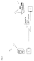
- a remote server system 100 is explained using Fig. 1 .
- Fig. 1 schematically shows the remote server system 100.
- the remote server system 100 is a system according to an embodiment according to the present invention.
- the remote server system 100 provides a distance user with some service.
- the remote server system 100 in the present embodiment provides some service to a user using a fishing boat 4 operating in a lake A (see Fig. 3 ) from a remote information center 110 through overseas communication companies 130 in countries of the world and domestic communication companies 120.
- the remote server system 100 is further explained using Fig. 2 .
- Fig. 2 schematically shows the remote server system 100.
- the remote server system 100 in the present embodiment provides the user using the fishing boat 4 operating in the lake A with a collection spot distribution map 55 and an income distribution map 56 described below.
- the fishing boat 4 operates to collect corbiculae.
- the remote server system 100 is configured such that a remote server 5 disposed in the remote information center 110 (see Fig. 1 ) can communicates with a terminal server 6 disposed in the operating fishing boat 4.
- the remote server 5 is configured to communicate with many terminal servers 6 at the same time.
- the remote server 5 is configured to communicate with a terminal server 6 disposed in a fishing boat operating in the lake A and a terminal server 6 disposed in a fishing boat operating in another fishing ground (a river, a lake or the like).
- the terminal servers 6 of the fishing boat 4 operating in the lake A sends at least operating days, positions and a catch (weight) of the corbiculae of the fishing boat 4 to the remote server 5.
- the remote server 5 makes the collection spot distribution map 55 and the income distribution map 56 described below based on information of the lake A, sent by the terminal servers 6, on the operating days, the positions and the catch of the corbiculae of the fishing boat 4.
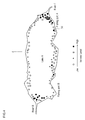
- the collection spot distribution map 55 is explained using Fig. 3 .
- Fig. 3 schematically shows the collection spot distribution map 55.
- the collection spot distribution map 55 expresses, for example, distribution of the collection spot by the fishing boat 4 in the lake A in a fishing season of the corbiculae.
- the collection spot is a spot where the fishing boat 4 is at anchor for a long time in order to collect the corbiculae.
- the collection spot distribution map 55 expresses distribution of the collection spot in the lake A in a planar view.
- the collection spot distribution map 55 according to the present embodiment classifies spots in the lake A depending on an anchor time level.
- the anchor time level is divided into four levels indicated by circles having shading depending on the time at each spot in the lake A when the fishing boat is at anchor.
- the income distribution map 56 is explained using Fig. 4 .
- Fig. 4 schematically shows the income distribution map 56.
- the income distribution map 56 expresses, for example, distribution of income of the lake A in the fishing season of the corbiculae.
- the income is the catch (weight) of the corbiculae which the fishing boat 4 collects.
- the income distribution map 56 expresses distribution of the income in the lake A in a planar view.
- the income distribution map 56 according to the present embodiment classifies spots in the lake A depending on to an income level.
- the income level is divided into four levels indicated by an open circle, a triangle, a square and a filled circle in descending order of the income at each spot in the lake A.
- a fuel consumption map 57 is explained using Fig. 5 .
- Fig. 5 schematically shows the fuel consumption map 57.
- the fuel consumption map 57 expresses, for example, distribution of fuel consumption of the operating fishing boat 4.
- the fuel consumption map 57 expresses the distribution of fuel consumption of the operating fishing boat 4 in a planar view.
- the fuel consumption map 57 according to the present embodiment classifies anchor spots (collection spots) in the lake A depending on a fuel consumption level.
- the fuel consumption level is divided into four levels indicated by an open circle, a triangle, a square and a filled circle in descending order of the fuel consumption of the fishing boat 4 operating in the lake A.
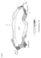
- An income-expenditure distribution map 58 is explained using Fig. 6 .
- Fig. 6 schematically shows the income-expenditure distribution map 58.
- the income-expenditure distribution map 58 expresses, for example, distribution of income and expenditure of the lake A.
- the income and expenditure indicates the sum of income and expenditure in the fishery production.
- the income is the catch of corbiculae by the fishing boat 4.
- the expenditure is the fuel consumption of the fishing boat 4.
- the catch and the fuel consumption are converted into the market price in order to sum up the income and the expenditure.
- the income-expenditure distribution map 58 expresses the distribution of the income and the expenditure of the lake A in a planar view.
- the income-expenditure distribution map 58 according to the present embodiment classifies spots in the lake A depending on income-expenditure level.
- the income-expenditure level is divided into four levels indicated by A, B, C and D in descending order of a ratio of the income to the expenditure.
- the income-expenditure level of each spot is expressed by shading.
- a flow of income distribution acquisition control S100 is explained using Fig. 7 .
- Fig. 7 shows the flow of the income distribution acquisition control S100 using a flowchart.
- the above-mentioned collection spot distribution map 55 and income distribution map 56 are acquired based on operation result of the fishing boat 4 in the lake A in the fishing season.
- a step S110 and a step S120 the above-mentioned collection spot distribution map 55 is acquired.
- the remote server 5 acquires the operating day and position of the fishing boat 4. Specifically, the remote server 5 acquires an average position of the fishing ship 4 in a predetermined period of the operating day. The remote server 5 considers a spot having most average positions in acquired average positions of the fishing ship 4 as a collection spot in the operation.
- the remote server 5 converts anchor time at the collection spot acquired in the step S110 into the anchor time level and then plots the anchor time level on the collection spot distribution map 55.
- step S130 and a step S140 the income distribution map 56 is acquired.
- the remote server 5 acquires the catch of corbiculae in the operating day. Specifically, the remote server 5 acquires the catch (weight) of corbiculae input by an operator after the operation.
- the weight is not limited as a unit of the catch of corbiculae inputted by the operator after the operation.
- the catch of corbiculae may be converted into the market price.
- the remote server 5 converts the catch of corbiculae acquired in the S130 into the income level and then plots the income-expenditure level at the collection spot acquired in the S110 of the income distribution map 56.
- step S150 and a step S160 the fuel consumption map 57 is acquired.
- the remote server 5 acquires the operating day, the position and the fuel consumption of the fishing boat 4. Specifically, the remote server 5 acquires the fuel consumption at the anchor spot of the operating day.
- the remote server 5 converts the fuel consumption acquired in the S150 into the fuel consumption level at the anchor spot and then plots the fuel consumption level on the fuel consumption map 57.
- the remote server 5 repeats the steps S110 to S160 with respect to each operating day and each fishing season.
- step S170 the remote server 5 makes the above-mentioned income-expenditure distribution map 58 based on the collection spot distribution map 55, the income distribution map 56 and the fuel consumption map 57.
- the remote server 5 can make the collection spot distribution map 55 and the income distribution map 56 of the lake A.
- the collection spot distribution map 55 and the income distribution map 56 is provided for users and is used for, for example, a fishery plan of the lake A of next year and beyond.
- the remote server system 100 and the income distribution acquisition control S100 make it possible to acquire income and operating time at each spot on each operating day, thus enabling to acquire the income distribution of the lake A.
- the present invention is not limited to acquire the income distribution of the lake A of the present embodiment.
- instantaneous fuel consumption of the fishing boat 4 may be acquired and an income-expenditure distribution map may be made such that the income is the catch of corbiculae and the expense is the instantaneous fuel consumption.
- An income rate map may be made, expressing the income for investment such that the income is the catch of corbiculae and the expense is the instantaneous fuel consumption.
- the present invention is not limited to acquire the collection spot distribution and the income distribution of the lake A focusing on one fishing boat 4 of the present embodiment.
- the collection spot distribution and the income distribution of the lake A are acquired focusing on a plurality of fishing boat 4 belonging to a fisheries union or the like.
- the present invention is applicable to a remote server.
Landscapes
- Engineering & Computer Science (AREA)
- Business, Economics & Management (AREA)
- Human Resources & Organizations (AREA)
- Economics (AREA)
- Strategic Management (AREA)
- Theoretical Computer Science (AREA)
- Entrepreneurship & Innovation (AREA)
- General Physics & Mathematics (AREA)
- Physics & Mathematics (AREA)
- Marketing (AREA)
- Tourism & Hospitality (AREA)
- General Business, Economics & Management (AREA)
- Development Economics (AREA)
- Educational Administration (AREA)
- Game Theory and Decision Science (AREA)
- Quality & Reliability (AREA)
- Operations Research (AREA)
- Databases & Information Systems (AREA)
- General Health & Medical Sciences (AREA)
- Life Sciences & Earth Sciences (AREA)
- Agronomy & Crop Science (AREA)
- Animal Husbandry (AREA)
- Marine Sciences & Fisheries (AREA)
- Mining & Mineral Resources (AREA)
- Health & Medical Sciences (AREA)
- Primary Health Care (AREA)
- Remote Sensing (AREA)
- Data Mining & Analysis (AREA)
- General Engineering & Computer Science (AREA)
- Management, Administration, Business Operations System, And Electronic Commerce (AREA)
- Navigation (AREA)
Applications Claiming Priority (2)
| Application Number | Priority Date | Filing Date | Title |
|---|---|---|---|
| JP2013176843A JP6178168B2 (ja) | 2013-08-28 | 2013-08-28 | 遠隔サーバ |
| PCT/JP2014/071314 WO2015029773A1 (ja) | 2013-08-28 | 2014-08-12 | 遠隔サーバ |
Publications (2)
| Publication Number | Publication Date |
|---|---|
| EP3040933A1 true EP3040933A1 (de) | 2016-07-06 |
| EP3040933A4 EP3040933A4 (de) | 2017-01-11 |
Family
ID=52586342
Family Applications (1)
| Application Number | Title | Priority Date | Filing Date |
|---|---|---|---|
| EP14839369.7A Ceased EP3040933A4 (de) | 2013-08-28 | 2014-08-12 | Remote-server |
Country Status (6)
| Country | Link |
|---|---|
| US (1) | US10223660B2 (de) |
| EP (1) | EP3040933A4 (de) |
| JP (1) | JP6178168B2 (de) |
| KR (1) | KR20160046789A (de) |
| CN (1) | CN105474251A (de) |
| WO (1) | WO2015029773A1 (de) |
Families Citing this family (3)
| Publication number | Priority date | Publication date | Assignee | Title |
|---|---|---|---|---|
| JP2016189083A (ja) * | 2015-03-30 | 2016-11-04 | ヤンマー株式会社 | 管理サーバ及び遠隔監視システム |
| CN105005943A (zh) * | 2015-07-10 | 2015-10-28 | 国家电网公司 | 电网资产组每万元售电量效益地图的绘制方法 |
| CN105005855A (zh) * | 2015-07-10 | 2015-10-28 | 国家电网公司 | 电网资产组每万元售电收入效益地图的绘制方法 |
Family Cites Families (10)
| Publication number | Priority date | Publication date | Assignee | Title |
|---|---|---|---|---|
| JPH10197622A (ja) | 1997-01-14 | 1998-07-31 | Kaijo Corp | 魚群探知機の表示方法 |
| US7904337B2 (en) * | 2004-10-19 | 2011-03-08 | Steve Morsa | Match engine marketing |
| JP2006320203A (ja) | 2005-05-17 | 2006-11-30 | Mori Kikai Seisakusho:Kk | 栽培漁業支援システム |
| JP4859433B2 (ja) * | 2005-10-12 | 2012-01-25 | 任天堂株式会社 | 位置検出システムおよび位置検出プログラム |
| CN101415015B (zh) * | 2007-10-19 | 2014-06-04 | 神达电脑股份有限公司 | 提供终端使用者内容的导航系统及架构 |
| KR20090066808A (ko) * | 2007-12-20 | 2009-06-24 | 이상준 | 무선통신수단을 이용한 엔진의 연료소비량 계측 시스템 |
| JP2008226259A (ja) * | 2008-04-04 | 2008-09-25 | Toa Harbor Works Co Ltd | 船舶運航管理システム |
| KR20100130822A (ko) * | 2009-06-04 | 2010-12-14 | 삼성중공업 주식회사 | 선박의 오염물질 모니터링 장치 및 방법 |
| JP5419622B2 (ja) * | 2009-10-01 | 2014-02-19 | 古野電気株式会社 | 船舶表示装置 |
| US8682888B2 (en) | 2011-12-14 | 2014-03-25 | Joseph Smith | System and methods for tasking, collecting, and dispatching information reports |
-
2013
- 2013-08-28 JP JP2013176843A patent/JP6178168B2/ja active Active
-
2014
- 2014-08-12 WO PCT/JP2014/071314 patent/WO2015029773A1/ja not_active Ceased
- 2014-08-12 CN CN201480046787.3A patent/CN105474251A/zh active Pending
- 2014-08-12 EP EP14839369.7A patent/EP3040933A4/de not_active Ceased
- 2014-08-12 KR KR1020167001516A patent/KR20160046789A/ko not_active Ceased
- 2014-08-12 US US14/913,506 patent/US10223660B2/en not_active Expired - Fee Related
Also Published As
| Publication number | Publication date |
|---|---|
| KR20160046789A (ko) | 2016-04-29 |
| JP6178168B2 (ja) | 2017-08-09 |
| US20160210579A1 (en) | 2016-07-21 |
| WO2015029773A1 (ja) | 2015-03-05 |
| JP2015046008A (ja) | 2015-03-12 |
| CN105474251A (zh) | 2016-04-06 |
| EP3040933A4 (de) | 2017-01-11 |
| US10223660B2 (en) | 2019-03-05 |
Similar Documents
| Publication | Publication Date | Title |
|---|---|---|
| Graham et al. | Upwelling shadows as nearshore retention sites: the example of northern Monterey Bay | |
| Filbee-Dexter et al. | Sea ice and substratum shape extensive kelp forests in the Canadian Arctic | |
| Guttridge et al. | Occurrence and habitat use of the critically endangered smalltooth sawfish Pristis pectinata in the Bahamas | |
| Azuz-Adeath et al. | Current demographic conditions and future scenarios in Mexico’s coastal zone | |
| KR101044243B1 (ko) | 스마트폰을 기반으로 하는 피싱인포맵 어플 장치 | |
| US20160210579A1 (en) | Remote server | |
| Nichol | Distribution, movements and habitat fidelity patterns of Fin Whales (Balaenoptera physalus) in Canadian Pacific Waters | |
| Feij et al. | Distribution of Arnoux's beaked whales (Berardius arnuxii) | |
| Jawad | Halicampus zavorensis Dawson, 1984 (Syngnathidae): new record for Iraqi marine waters and for the Arabian Gulf area | |
| KR102111636B1 (ko) | 해황정보 제공시스템 및 이를 이용한 해황정보 제공방법 | |
| Dosell et al. | Using evidence from voluntary fisheries data collection programmes to support marine spatial planning and resolve multiple-use conflicts | |
| Tummala et al. | Benefits derived by the fisherman using Potential Fishing Zone (PFZ) advisories | |
| Carlson et al. | Habitat use and movement patterns of oceanic whitetip, bigeye thresher and dusky sharks based on archival satellite tags | |
| Howe et al. | Participatory science and directed survey methods: A case study with odontocetes in the Maui Nui region of the Hawaiian Islands | |
| Roshan | Study on cyclone ockhi: Disaster risk management and sea safety in the Indian marine fisheries sector | |
| Ferguson | Cetacean population density in the eastern Pacific Ocean: analyzing patterns with predictive spatial models | |
| Callaghan et al. | The unusual inter-tidal niche of the rare moss Bryum marratii Wilson | |
| Balasubramanian | Satellite data aid India’s fishermen for better livelihood | |
| Whiting | Movements and distribution of dugongs (Dugong dugon) in a macro-tidal environment in northern Australia | |
| Singh et al. | mKRISHI® Fisheries-A Blue Ocean Innovation | |
| Nayak | From ocean science to sustainable blue economy | |
| KR101901416B1 (ko) | 바다의 환경에 대한 요소별 가중치 알고리즘을 이용한 낚시지수 시스템 | |
| Hart et al. | Seabird responses to altered marine vessel activity during the COVID-19 anthropause: insights from citizen science | |
| Aram et al. | Mobile advisory information to reduce coastal risks and to enhance livelihood activities in the South East coast of India | |
| Bolong et al. | ICT utilisation and its impact on the income of young fishermen in Malaysia |
Legal Events
| Date | Code | Title | Description |
|---|---|---|---|
| PUAI | Public reference made under article 153(3) epc to a published international application that has entered the european phase |
Free format text: ORIGINAL CODE: 0009012 |
|
| 17P | Request for examination filed |
Effective date: 20160329 |
|
| AK | Designated contracting states |
Kind code of ref document: A1 Designated state(s): AL AT BE BG CH CY CZ DE DK EE ES FI FR GB GR HR HU IE IS IT LI LT LU LV MC MK MT NL NO PL PT RO RS SE SI SK SM TR |
|
| AX | Request for extension of the european patent |
Extension state: BA ME |
|
| DAX | Request for extension of the european patent (deleted) | ||
| A4 | Supplementary search report drawn up and despatched |
Effective date: 20161212 |
|
| RIC1 | Information provided on ipc code assigned before grant |
Ipc: G06Q 50/02 20120101AFI20161206BHEP Ipc: G06Q 10/06 20120101ALI20161206BHEP Ipc: G06F 17/30 20060101ALI20161206BHEP |
|
| STAA | Information on the status of an ep patent application or granted ep patent |
Free format text: STATUS: EXAMINATION IS IN PROGRESS |
|
| 17Q | First examination report despatched |
Effective date: 20180703 |
|
| REG | Reference to a national code |
Ref country code: DE Ref legal event code: R003 |
|
| STAA | Information on the status of an ep patent application or granted ep patent |
Free format text: STATUS: THE APPLICATION HAS BEEN REFUSED |
|
| 18R | Application refused |
Effective date: 20190629 |