EP3036508B1 - Navigation using dynamic speed limits - Google Patents
Navigation using dynamic speed limits Download PDFInfo
- Publication number
- EP3036508B1 EP3036508B1 EP14747775.6A EP14747775A EP3036508B1 EP 3036508 B1 EP3036508 B1 EP 3036508B1 EP 14747775 A EP14747775 A EP 14747775A EP 3036508 B1 EP3036508 B1 EP 3036508B1
- Authority
- EP
- European Patent Office
- Prior art keywords
- speed limit
- vehicle
- road segment
- dynamic speed
- location
- Prior art date
- Legal status (The legal status is an assumption and is not a legal conclusion. Google has not performed a legal analysis and makes no representation as to the accuracy of the status listed.)
- Not-in-force
Links
Images


Classifications
-
- G—PHYSICS
- G01—MEASURING; TESTING
- G01C—MEASURING DISTANCES, LEVELS OR BEARINGS; SURVEYING; NAVIGATION; GYROSCOPIC INSTRUMENTS; PHOTOGRAMMETRY OR VIDEOGRAMMETRY
- G01C21/00—Navigation; Navigational instruments not provided for in groups G01C1/00 - G01C19/00
- G01C21/26—Navigation; Navigational instruments not provided for in groups G01C1/00 - G01C19/00 specially adapted for navigation in a road network
- G01C21/34—Route searching; Route guidance
- G01C21/36—Input/output arrangements for on-board computers
- G01C21/3697—Output of additional, non-guidance related information, e.g. low fuel level
-
- G—PHYSICS
- G08—SIGNALLING
- G08G—TRAFFIC CONTROL SYSTEMS
- G08G1/00—Traffic control systems for road vehicles
- G08G1/09—Arrangements for giving variable traffic instructions
- G08G1/0962—Arrangements for giving variable traffic instructions having an indicator mounted inside the vehicle, e.g. giving voice messages
- G08G1/09626—Arrangements for giving variable traffic instructions having an indicator mounted inside the vehicle, e.g. giving voice messages where the origin of the information is within the own vehicle, e.g. a local storage device, digital map
-
- G—PHYSICS
- G08—SIGNALLING
- G08G—TRAFFIC CONTROL SYSTEMS
- G08G1/00—Traffic control systems for road vehicles
- G08G1/09—Arrangements for giving variable traffic instructions
- G08G1/0962—Arrangements for giving variable traffic instructions having an indicator mounted inside the vehicle, e.g. giving voice messages
- G08G1/0967—Systems involving transmission of highway information, e.g. weather, speed limits
- G08G1/096708—Systems involving transmission of highway information, e.g. weather, speed limits where the received information might be used to generate an automatic action on the vehicle control
- G08G1/096716—Systems involving transmission of highway information, e.g. weather, speed limits where the received information might be used to generate an automatic action on the vehicle control where the received information does not generate an automatic action on the vehicle control
-
- G—PHYSICS
- G08—SIGNALLING
- G08G—TRAFFIC CONTROL SYSTEMS
- G08G1/00—Traffic control systems for road vehicles
- G08G1/09—Arrangements for giving variable traffic instructions
- G08G1/0962—Arrangements for giving variable traffic instructions having an indicator mounted inside the vehicle, e.g. giving voice messages
- G08G1/0967—Systems involving transmission of highway information, e.g. weather, speed limits
- G08G1/096733—Systems involving transmission of highway information, e.g. weather, speed limits where a selection of the information might take place
- G08G1/096758—Systems involving transmission of highway information, e.g. weather, speed limits where a selection of the information might take place where no selection takes place on the transmitted or the received information
-
- G—PHYSICS
- G08—SIGNALLING
- G08G—TRAFFIC CONTROL SYSTEMS
- G08G1/00—Traffic control systems for road vehicles
- G08G1/09—Arrangements for giving variable traffic instructions
- G08G1/0962—Arrangements for giving variable traffic instructions having an indicator mounted inside the vehicle, e.g. giving voice messages
- G08G1/0967—Systems involving transmission of highway information, e.g. weather, speed limits
- G08G1/096766—Systems involving transmission of highway information, e.g. weather, speed limits where the system is characterised by the origin of the information transmission
- G08G1/096775—Systems involving transmission of highway information, e.g. weather, speed limits where the system is characterised by the origin of the information transmission where the origin of the information is a central station
Definitions
- the present disclosure relates to the field of wireless communications.
- the present disclosure relates to providing navigation guidance to vehicles.
- PNDs personal navigation devices
- Conventional personal navigation devices such as TomTom Go, Mio Moov, and Google Navigate
- a driver would have to mentally compute the speed limits of certain roads in some situations in order to drive within the speed limits of such roads.
- KM/H 20 Kilometers per hour
- electric speed limit sign may be provided, where the speed limit sign may indicate 80 KMPH between 8AM and 5PM, but may indicate 100 KM/H the rest of the time.
- the conventional PNDs have failed to cope with the situations of variable speed limits described above.
- US 2012/059574 A1 relates to a traffic control system that includes a vehicle unit associated with a vehicle on a highway, one or more roadside units proximate the highway, and a traffic controller.
- the vehicle unit transmits a vehicle speed to the roadside unit, when in wireless communication range.
- the roadside unit transmits the vehicle speed to the traffic controller.
- the traffic controller receives vehicle speed data from a plurality of vehicles, and determines a suggested speed for each vehicle. The suggested speed may be correlated with an average speed of vehicles on a portion of the highway.
- a method and a navigation device as set forth in the independent claims are provided. Embodiments of the invention are claimed in the dependent claims.
- the present disclosure relates to providing navigation guidance to vehicles.
- a method may include determining a location of a vehicle in a road segment by a navigation device, where the location of the vehicle in the road segment includes a lane the vehicle is in, determining a dynamic speed limit in accordance with the location of the vehicle in the road segment, and displaying the dynamic speed limit in a display of the navigation device.
- a navigation device comprises a control unit including processing logic, and the processing logic comprises logic configured to determine a location of a vehicle in a road segment by a navigation device, where the location of the vehicle in the road segment includes a lane the vehicle is in, logic configured to determine a dynamic speed limit in accordance with the location of the vehicle in the road segment, and logic configured to display the dynamic speed limit in a display of the navigation device.
- a non-transitory medium storing instructions for execution by one or more computer systems, the instructions comprise instructions for determining a location of a vehicle in a road segment by a navigation device, where the location of the vehicle in the road segment includes a lane the vehicle is in, instructions for determining a dynamic speed limit in accordance with the location of the vehicle in the road segment, and instructions for displaying the dynamic speed limit in a display of the navigation device.
- an apparatus comprises means for determining a location of a vehicle in a road segment by a navigation device, where the location of the vehicle in the road segment includes a lane the vehicle is in, means for determining a dynamic speed limit in accordance with the location of the vehicle in the road segment, and means for displaying the dynamic speed limit in a display of the navigation device.
- FIG. 1 illustrates examples of various road segments of an area according to some aspects of the present disclosure.
- a section of a map may be split into road segments, connecting a Start location 102 and an End location 104.
- a line connecting two circles indicates a road segment, such as road segments A1 through A3, B1 through B3, C1 through C3, D1 and D2.
- a circle indicates an intersection between two or more road segments.
- the speed limit of a road segment may be changing based on various conditions. Such change of speed limit for a road segment is also referred to as dynamic speed limit of a road segment.
- the conditions for such dynamic speed limit may include, but not limited to: 1) current time and date; 2) current weather condition; 3) current road condition; and 4) a vehicle class, where the vehicle class may include a weight of the vehicle.
- the dynamic speed limit may further include, but not limited to: 1) the dynamic speed limit for the lane the vehicle is in at the current time and date; 2) the dynamic speed limit for a vehicle class at the current time and date; 3) the dynamic speed limit for the road segment for day time traffic; 4) the dynamic speed limit for the road segment for night time traffic; 5) the dynamic speed limit for the road segment for rush hour traffic; 6) the dynamic speed limit for the road segment for non-rush hour traffic; and 7) the dynamic speed limit for the road segment in one of Spring, Summer, Autumn, and Winter.
- FIG. 2 illustrates an example of dynamic speed limits for the various road segments of FIG. 1 based at least in part on time of the day according to some aspects of the present disclosure.
- road segment A1 may have a default speed limit of 100 kilometer per hour (KM/H), a day time speed limit of 100 KM/H, and an evening or night speed limit of 80 KM/H.
- road segment B2 may have a default speed limit of 50 KM/H, a day time speed limit of 50 KM/H, and an evening or night speed limit of 50 KM/H.
- Road segment C3 may have a default speed limit of 40 KM/H, a day time speed limit of 40 KM/H, and an evening or night speed limit of 40 KM/H.
- Road segment D2 may have a default speed limit of 80 KM/H, a day time speed limit of 80 KM/H, and an evening or night speed limit of 60 KM/H. Note that some road segments may have different speed limits for different times of a day, for example different speed limits for day time and evening; while other road segments may have the same speed limit for both the day time and evening. To accurately inform users the correct speed limit for the road segments they may travel, the methods of the current disclosure take such changes in speed limit for different road segments into account in determining the dynamic speed limit of a road segment to the users.
- FIG. 3 illustrates another example of dynamic speed limits for the various road segments of FIG. 1 based at least in part on rush hour and non-rush hour according to some aspects of the present disclosure.
- road segment A2 may have a default speed limit of 45 KM/H, a rush hour speed limit of 45 KM/H, and a non-rush hour speed limit of 50 KM/H.
- road segment B1 may have a default speed limit of 60 KM/H, a rush hour speed limit of 60 KM/H, and a non-rush hour speed limit of 70 KM/H.
- Road segment C1 may have a default speed limit of 100 KM/H, a rush hour speed limit of 100 KM/H, and a non-rush hour speed limit of 120 KM/H.
- Road segment D1 may have a default speed limit of 100 KM/H, a rush hour speed limit of 100 KM/H, and a non-rush hour speed limit of 100 KM/H.
- some road segments may have different speed limits for rush hour and for non-rush hour traffic; while other road segments may have the same speed limit for both the rush hour and non-rush hour traffic.
- the methods of the current disclosure take such conditions for the road segments into account and provide navigation guidance to the users that include such dynamic speed limits.
- FIG. 4 illustrates yet another example of dynamic speed limits for the various road segments of FIG. 1 based at least in part on different seasons in a year according to some aspects of the present disclosure.
- road segment A3 may have a speed limit of 90 KM/H for Spring, which is kept the same for Summer and Autumn, and the speed limits drops to 80 KM/H for Winter.
- Road segment B2 may have a speed limit of 45 KM/H for Spring, which is increased to 50 KM/H for Summer and Autumn, and drops to 40 KM/H for Winter.
- Road segment C3 may have the same speed limit of 40 KM/H for all four seasons.
- Road segment D2 may have a speed limit of 70 KM/H for Spring, which increases to 80 KM/H in Summer and Autumn, and decreases to 60 KM/H in Winter. According to aspects of the present disclosure, some road segments may have different speed limits for different seasons of the year; while other road segments may have the same speed limit for all four seasons. To accurately inform users the correct speed limit for the road segments, the methods of the current disclosure take such seasonal changes in speed limit for different road segments into account in determining the dynamic speed limit of a road segment to the users.
- FIG. 5A and FIG. 5B illustrate yet another example of dynamic speed limits for the various road segments of FIG. 1 based at least in part on different lanes in a road segment according to some aspects of the present disclosure.
- a plurality of vehicles may travel in various lanes of a road segment.
- vehicle 502 may be in Lane 1
- vehicle 504 may be in Lane 2
- vehicle 506 may be in Lane 3
- vehicle 508 may be in Lane 4.
- vehicle 510 may be in the process of changing lanes from Lane 2 to Lane 1
- vehicle 512 may be in the process of changing lanes from Lane 3 to Lane 4.
- one or more lanes such as Lane 1 in FIG.
- 5A may be express lanes or toll lanes, where vehicles in these lanes may travel at a different speed limit than the speed limit in other lanes in the road segment.
- Methods of the current disclosure take such different speed limits for different lanes into account and provide such information to the users in order to accurately inform users the correct speed limit for each lane of the road segments they may be in.
- the dynamic speed limit may be updated as a result of the vehicle has moved from one lane to another lane in the road segment.
- FIG. 5B examples of different speed limits for the various road segments of FIG. 1 are shown.
- the speed limit for Lane 1 may be 100 KM/H
- the speed limit for Lanes 2-4 may be 90 KM/H.
- the speed limit for Lanes 1-2 may be 70 KM/H
- the speed limit for Lanes 3-4 is labeled as not applicable (NA).
- the speed limit for Lane 1 may be 120 KM/H
- the speed limit for Lanes 2-4 may be 110 KM/H.
- the speed limit for Lanes 1-3 may be 80 KM/H, and assuming road segment D2 has only three lanes, the speed limit for Lane 4 is labeled as not applicable. According to aspects of the present disclosure, disclosed methods take such different speed limits for different lanes into account and provide such information to the users in order to accurately inform users the correct speed limit for each lane of the road segments they may be in.
- FIG. 6A and FIG. 6B illustrate yet another example of dynamic speed limits for the various road segments of FIG. 1 based at least in part on different vehicle classes according to some aspects of the present disclosure.
- a plurality of vehicles may travel in various lanes of a road segment.
- vehicles 602, 604, and 608 may belong to one vehicle class, such as the class of cars; vehicles 606 and 610 may belong to another vehicle class, such as the class of commercial passenger minivans; vehicle 612 may belong to yet another vehicle class, such as the class of light trucks; and vehicle 614 may belong to yet another vehicle class, such as the class of heavy trucks.
- different classes of vehicles may be required to travel in different lanes (such as heavy trucks may be required to travel in Lane 5 in the example of FIG. 6A ) and to travel at different speed limits.
- Methods of the current disclosure take such vehicle classes and their corresponding different speed limits into account and provide such information to the users in order to accurately inform users the correct speed limit for each vehicle class for the road segments they may be in.
- FIG. 6B examples of different speed limits for different classes of vehicles for the various road segments of FIG. 1 are shown.
- the speed limit for vehicles having weight less than 5 tons may be 50 KM/H
- the speed limit for vehicles having weight between 5 tons to 10 tons may be 45 KM/H
- the speed limit for vehicles having weight over 10 tons may be 40 KM/H.
- the speed limit for vehicles having weight less than 5 tons and for vehicles having weight between 5 tons to 10 tons may be 120 KM/H
- the speed limit for vehicles having weight over 10 tons may be 100 KM/H.
- the speed limit for vehicles having weight less than 5 tons may be 80 KM/H
- the speed limit for vehicles having weight between 5 tons to 10 tons may be 70 KM/H
- the speed limit for vehicles having weight over 10 tons may be 60 KM/H
- the speed limit for vehicles of all classes may be 100 KM/H. According to aspects of the present disclosure, disclosed methods take such vehicle classes and their corresponding different speed limits into account and provide such information to the users in order to accurately inform users the correct speed limit for each vehicle class for the road segments they may be in.
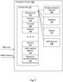
- FIG. 7 illustrates a block diagram of an exemplary navigation device configured to provide navigation according to some aspects of the present disclosure.
- the navigation device 702 includes a control unit 720.
- the control unit 720 may include one or more processor(s) 722 and associated memory/storage 724.
- the control unit 720 may also include software 726, hardware 728, and firmware 730.
- the control unit 720 includes an on-board diagnostic (OBD) interface module 732 configured to interface and collect data from an OBD module of the vehicle.
- the control unit 720 further includes a navigation guidance module 734 configured to provide navigation guidance to the user.
- the navigation device 702 may further include a wireless network interface 740, a database 742, a display 744, and a GPS receiver 746 communicatively coupled to the control unit 720. Note that the GPS receiver 746 is optional as the navigation device 702 can be configured to receive GNSS readings from an external source.
- the wireless network interface 740 can be configured to enable the navigation device 702 to communicate with other servers, computers, navigation devices, and vehicles via one or more communication networks. In addition, the wireless network interface 740 can be configured to enable the navigation device 702 to communicate with one or more crowdsourcing databases.
- an on board diagnostics (OBD) module of the vehicle may be configured to collect OBD data, including but not limited to: vehicle model/class, manufacture year, fuel system status, engine load value, engine revolutions per minute (RPM), speed, intake air temperature, run time since engine start, fuel level, barometric pressure, accelerator pedal position, cruise control, brake pressed, park/neutral position, motion sensor readings, odometer readings, and steering angle readings.
- OBD data including but not limited to: vehicle model/class, manufacture year, fuel system status, engine load value, engine revolutions per minute (RPM), speed, intake air temperature, run time since engine start, fuel level, barometric pressure, accelerator pedal position, cruise control, brake pressed, park/neutral position, motion sensor readings, odometer readings, and steering angle readings.
- the navigation device 702 may be configured to receive GNSS data from an external GPS receiver. The GNSS data received may include, but not limited to: latitude, longitude, altitude, and time of the vehicle.
- the OBD module may send the OBD data collected to the navigation device 702 via the OBD interface module 732.
- the control unit 720 may be configured to use the OBD data collected by the OBD interface module 732, GNSS readings collected by the GPS receiver 746 (or by an external GPS receiver), and map data stored in database 742 to determine the location of the vehicle in a road segment, such as which lane in a road segment the vehicle may be in.
- the navigation device 702 may use the OBD data (angle of heading, odometer readings, speedometer readings, etc.), GNSS readings (latitude, longitude, time, etc.), and the map data to determine when a vehicle first enters a road segment.
- the navigation device 702 may use the OBD data, GNSS readings, and the map data to determine when the vehicle performs a lane change.
- OBD interface module 732 and navigation guidance module 734 are illustrated separately from processor(s) 722 and/or hardware 728 for clarity, but may be combined and/or implemented in the processor(s) 722 and/or hardware 728 based on instructions in the software 726 and the firmware 730.
- control unit 720 can be configured to implement methods of providing navigation guidance to vehicles.
- the control unit 720 can be configured to implement functions of the navigation device 702 described in FIG. 1 through FIG. 6B .
- FIG. 8 illustrates a flow diagram of exemplary logical operations performed by the control unit of FIG. 7 to provide navigation guidance according to some aspects of the present disclosure.
- the navigation device determines a location of a vehicle in a road segment, where the location of the vehicle in the road segment includes a lane the vehicle is in.
- the navigation device 702 may determine the location of the vehicle in a road segment using GNSS readings as well as using the OBD information received via the OBD module interface 732.
- the navigation device determines a dynamic speed limit in accordance with the location of the vehicle in the road segment.
- the navigation device displays the dynamic speed limit in a display.
- the methods performed in block 804 may further include methods performed in blocks 808, 810 and 812.
- the navigation device 702 retrieves a set of rules for deriving the dynamic speed limit, and determines the dynamic speed limit based on the location of the vehicle in the road segment and the set of rules for deriving the dynamic speed limit.
- the set of rules for deriving the dynamic speed limit comprises at least one of: current time and date, current weather condition, current road condition, and a vehicle class, wherein the vehicle class includes a weight of the vehicle.
- the navigation device 702 may be configured to obtain a current time and date, and retrieve the dynamic speed limit from a database of the navigation device based on the current time and date, and the location of the vehicle in the road segment.
- the dynamic speed limit may comprise at least one of: the dynamic speed limit for the lane the vehicle is in at the current time and date, the dynamic speed limit for a vehicle class at the current time and date, the dynamic speed limit for the road segment for day time traffic, the dynamic speed limit for the road segment for night time traffic, the dynamic speed limit for the road segment for rush hour traffic, the dynamic speed limit for the road segment for non-rush hour traffic, and the dynamic speed limit for the road segment in one of Spring, Summer, Autumn, and Winter.
- the navigation device 702 may determine the dynamic speed limit based on one or more of the above information in combination.
- the navigation device 702 may be configured to receive crowdsourcing data from a server based on a speed limit posted for the road segment, where the crowdsourcing data may be gathered from a plurality of vehicles, and where the crowdsourcing data may include on board diagnostics data (OBD) correlated with time stamps and GPS locations reported by the plurality of vehicles, and determine the dynamic speed limit based on the speed limit posted for the road segment.
- OBD on board diagnostics data
- the navigation device 702 may be configured to detect a current speed of the vehicle, compare the current speed of the vehicle to the dynamic speed limit of the road segment, and generate a warning to a driver in response to the current speed exceeds the dynamic speed limit of the road segment.
- FIG. 7 and FIG. 8 provide means for determining a location of a vehicle in a road segment by a navigation device; means for determining a dynamic speed limit in accordance with the location of the vehicle in the road segment; means for displaying the dynamic speed limit in a display of the navigation device; means for retrieving a set of rules for deriving the dynamic speed limit; means for determining the dynamic speed limit based on the location of the vehicle in the road segment and the set of rules for deriving the dynamic speed limit; means for obtaining a current time and date; means for retrieving the dynamic speed limit from a database of the navigation device based on the current time and date, and the location of the vehicle in the road segment; means for receiving crowdsourcing data from a server based on a speed limit posted for the road segment; means for determining the dynamic speed limit based on the speed limit posted for the road segment; means for detecting a current speed of the vehicle; means for comparing the current speed of the vehicle to
- the methodologies and navigation device described herein can be implemented by various means depending upon the application. For example, these methodologies can be implemented in hardware, firmware, software, or a combination thereof.
- the processing units can be implemented within one or more application specific integrated circuits (ASICs), digital signal processors (DSPs), digital signal processing devices (DSPDs), programmable logic devices (PLDs), field programmable gate arrays (FPGAs), processors, controllers, micro-controllers, microprocessors, electronic devices, other electronic units designed to perform the functions described herein, or a combination thereof.
- ASICs application specific integrated circuits
- DSPs digital signal processors
- DSPDs digital signal processing devices
- PLDs programmable logic devices
- FPGAs field programmable gate arrays
- processors controllers, micro-controllers, microprocessors, electronic devices, other electronic units designed to perform the functions described herein, or a combination thereof.
- control logic encompasses logic implemented by software, hardware, firmware, or a combination.
- the methodologies can be implemented with modules (e.g., procedures, functions, and so on) that perform the functions described herein.
- Any machine readable medium tangibly embodying instructions can be used in implementing the methodologies described herein.
- software codes can be stored in a memory and executed by a processing unit.
- Memory can be implemented within the processing unit or external to the processing unit.
- memory refers to any type of long term, short term, volatile, nonvolatile, or other storage devices and is not to be limited to any particular type of memory or number of memories, or type of media upon which memory is stored.
- the functions may be stored as one or more instructions or code on a computer-readable medium. Examples include computer-readable media encoded with a data structure and computer-readable media encoded with a computer program. Computer-readable media may take the form of an article of manufacturer. Computer-readable media includes physical computer storage media and/or other non-transitory media. A storage medium may be any available medium that can be accessed by a computer.
- such computer-readable media can comprise RAM, ROM, EEPROM, CD-ROM or other optical disk storage, magnetic disk storage or other magnetic storage devices, or any other medium that can be used to store desired program code in the form of instructions or data structures and that can be accessed by a computer; disk and disc, as used herein, includes compact disc (CD), laser disc, optical disc, digital versatile disc (DVD), floppy disk and Blu-ray disc where disks usually reproduce data magnetically, while discs reproduce data optically with lasers. Combinations of the above should also be included within the scope of computer-readable media.
- a communication apparatus may include a transceiver having signals indicative of instructions and data.
- the instructions and data are configured to cause one or more processors to implement the functions outlined in the claims. That is, the communication apparatus includes transmission media with signals indicative of information to perform disclosed functions. At a first time, the transmission media included in the communication apparatus may include a first portion of the information to perform the disclosed functions, while at a second time the transmission media included in the communication apparatus may include a second portion of the information to perform the disclosed functions.
- a WWAN may be a Code Division Multiple Access (CDMA) network, a Time Division Multiple Access (TDMA) network, a Frequency Division Multiple Access (FDMA) network, an Orthogonal Frequency Division Multiple Access (OFDMA) network, a Single-Carrier Frequency Division Multiple Access (SC-FDMA) network, a Long Term Evolution (LTE) network, a WiMAX (IEEE 802.16) network and so on.
- CDMA Code Division Multiple Access
- TDMA Time Division Multiple Access
- FDMA Frequency Division Multiple Access
- OFDMA Orthogonal Frequency Division Multiple Access
- SC-FDMA Single-Carrier Frequency Division Multiple Access
- LTE Long Term Evolution
- WiMAX IEEE 802.16
- a CDMA network may implement one or more radio access technologies (RATs) such as cdma2000, Wideband-CDMA (W-CDMA), and so on.
- Cdma2000 includes IS-95, IS2000, and IS-856 standards.
- a TDMA network may implement Global System for Mobile Communications (GSM), Digital Advanced Mobile Phone System (D-AMPS), or some other RAT.
- GSM and W-CDMA are described in documents from a consortium named "3rd Generation Partnership Project" (3GPP).
- Cdma2000 is described in documents from a consortium named "3rd Generation Partnership Project 2" (3GPP2).
- 3GPP and 3GPP2 documents are publicly available.
- a WLAN may be an IEEE 802.11x network
- a WPAN may be a Bluetooth network, an IEEE 802.15x, or some other type of network.
- the techniques may also be implemented in conjunction with any combination of WWAN, WLAN and/or WPAN.
- a server which are capable of communication with a server, such as via the Internet, Wi-Fi, or other network, and regardless of whether satellite signal reception, assistance data reception, and/or position-related processing occurs at the device, at a server, or at another device associated with the network. Any operable combination of the above are also considered a "mobile station.”
Landscapes
- Physics & Mathematics (AREA)
- General Physics & Mathematics (AREA)
- Engineering & Computer Science (AREA)
- Radar, Positioning & Navigation (AREA)
- Remote Sensing (AREA)
- Life Sciences & Earth Sciences (AREA)
- Atmospheric Sciences (AREA)
- Automation & Control Theory (AREA)
- Navigation (AREA)
- Traffic Control Systems (AREA)
Description
- This application claims the benefit of
U.S. Application Number 13/971,589 - The present disclosure relates to the field of wireless communications. In particular, the present disclosure relates to providing navigation guidance to vehicles.
- Conventional personal navigation devices (PDNs), such as TomTom Go, Mio Moov, and Google Navigate, typically show the summer speed limits all year around. With these conventional PNDs, a driver would have to mentally compute the speed limits of certain roads in some situations in order to drive within the speed limits of such roads. For example, a user may have to subtract 20 Kilometers per hour (KM/H) from the speed limits displayed by the PNDs in winter in order to drive within the speed limits, especially in situations when the user has missed the speed limit signs. For some other roads for example, electric speed limit sign may be provided, where the speed limit sign may indicate 80 KMPH between 8AM and 5PM, but may indicate 100 KM/H the rest of the time. The conventional PNDs have failed to cope with the situations of variable speed limits described above.
- Therefore, there is a need for method, device, computer program product, and apparatus that can address the above issues of the conventional methods and devices.
Attention is drawn toUS 2012/059574 A1 which relates to a traffic control system that includes a vehicle unit associated with a vehicle on a highway, one or more roadside units proximate the highway, and a traffic controller. The vehicle unit transmits a vehicle speed to the roadside unit, when in wireless communication range. The roadside unit transmits the vehicle speed to the traffic controller.
The traffic controller receives vehicle speed data from a plurality of vehicles, and determines a suggested speed for each vehicle. The suggested speed may be correlated with an average speed of vehicles on a portion of the highway. - In accordance with the present invention, a method and a navigation device, as set forth in the independent claims are provided. Embodiments of the invention are claimed in the dependent claims.
The present disclosure relates to providing navigation guidance to vehicles. According to embodiments of the present disclosure, a method may include determining a location of a vehicle in a road segment by a navigation device, where the location of the vehicle in the road segment includes a lane the vehicle is in, determining
a dynamic speed limit in accordance with the location of the vehicle in the road segment, and displaying the dynamic speed limit in a display of the navigation device. - In yet another embodiment, a navigation device comprises a control unit including processing logic, and the processing logic comprises logic configured to determine a location of a vehicle in a road segment by a navigation device, where the location of the vehicle in the road segment includes a lane the vehicle is in, logic configured to determine a dynamic speed limit in accordance with the location of the vehicle in the road segment, and logic configured to display the dynamic speed limit in a display of the navigation device.
- In yet another embodiment, a non-transitory medium storing instructions for execution by one or more computer systems, the instructions comprise instructions for determining a location of a vehicle in a road segment by a navigation device, where the location of the vehicle in the road segment includes a lane the vehicle is in, instructions for determining a dynamic speed limit in accordance with the location of the vehicle in the road segment, and instructions for displaying the dynamic speed limit in a display of the navigation device.
- In yet another embodiment, an apparatus comprises means for determining a location of a vehicle in a road segment by a navigation device, where the location of the vehicle in the road segment includes a lane the vehicle is in, means for determining a dynamic speed limit in accordance with the location of the vehicle in the road segment, and means for displaying the dynamic speed limit in a display of the navigation device.
- The aforementioned features and advantages of the disclosure, as well as additional features and advantages thereof, will be more clearly understandable after reading detailed descriptions of embodiments of the disclosure in conjunction with the following drawings.
-
FIG. 1 illustrates examples of various road segments of an area according to some aspects of the present disclosure. -
FIG. 2 illustrates an example of dynamic speed limits for the various road segments ofFIG. 1 based at least in part on time of the day according to some aspects of the present disclosure. -
FIG. 3 illustrates another example of dynamic speed limits for the various road segments ofFIG. 1 based at least in part on rush hour and non-rush hour according to some aspects of the present disclosure. -
FIG. 4 illustrates yet another example of dynamic speed limits for the various road segments ofFIG. 1 based at least in part on different seasons in a year according to some aspects of the present disclosure. -
FIG. 5A andFIG. 5B illustrate yet another example of dynamic speed limits for the various road segments ofFIG. 1 based at least in part on different lanes in a road segment according to some aspects of the present disclosure. -
FIG. 6A andFIG. 6B illustrate yet another example of dynamic speed limits for the various road segments ofFIG. 1 based at least in part on different vehicle classes according to some aspects of the present disclosure. -
FIG. 7 illustrates a block diagram of an exemplary navigation device configured to provide navigation according to some aspects of the present disclosure. -
FIG. 8 illustrates a flow diagram of exemplary logical operations performed by the control unit ofFIG. 7 to provide navigation guidance according to some aspects of the present disclosure. - Like numbers are used throughout the figures.
- Embodiments of method, device, computer program product, and apparatus for providing navigation guidance to vehicles are disclosed. The following descriptions are presented to enable any person skilled in the art to make and use the disclosure. Descriptions of specific embodiments and applications are provided only as examples. Various modifications and combinations of the examples described herein will be readily apparent to those skilled in the art, and the general principles defined herein may be applied to other examples and applications without departing from the scope of the disclosure. Thus, the present disclosure is not intended to be limited to the examples described and shown, but is to be accorded the widest scope consistent with the principles and features disclosed herein. The word "exemplary" or "example" is used herein to mean "serving as an example, instance, or illustration." Any aspect or embodiment described herein as "exemplary" or as an "example" in not necessarily to be construed as preferred or advantageous over other aspects or embodiments.
-
FIG. 1 illustrates examples of various road segments of an area according to some aspects of the present disclosure. In the example shown inFIG. 1 , a section of a map may be split into road segments, connecting aStart location 102 and anEnd location 104. A line connecting two circles indicates a road segment, such as road segments A1 through A3, B1 through B3, C1 through C3, D1 and D2. A circle indicates an intersection between two or more road segments. According to aspects of the present disclosure, the speed limit of a road segment may be changing based on various conditions. Such change of speed limit for a road segment is also referred to as dynamic speed limit of a road segment. The conditions for such dynamic speed limit may include, but not limited to: 1) current time and date; 2) current weather condition; 3) current road condition; and 4) a vehicle class, where the vehicle class may include a weight of the vehicle. In addition, the dynamic speed limit may further include, but not limited to: 1) the dynamic speed limit for the lane the vehicle is in at the current time and date; 2) the dynamic speed limit for a vehicle class at the current time and date; 3) the dynamic speed limit for the road segment for day time traffic; 4) the dynamic speed limit for the road segment for night time traffic; 5) the dynamic speed limit for the road segment for rush hour traffic; 6) the dynamic speed limit for the road segment for non-rush hour traffic; and 7) the dynamic speed limit for the road segment in one of Spring, Summer, Autumn, and Winter. -
FIG. 2 illustrates an example of dynamic speed limits for the various road segments ofFIG. 1 based at least in part on time of the day according to some aspects of the present disclosure. In the example shown inFIG. 2 , road segment A1 may have a default speed limit of 100 kilometer per hour (KM/H), a day time speed limit of 100 KM/H, and an evening or night speed limit of 80 KM/H. Similarly, road segment B2 may have a default speed limit of 50 KM/H, a day time speed limit of 50 KM/H, and an evening or night speed limit of 50 KM/H. Road segment C3 may have a default speed limit of 40 KM/H, a day time speed limit of 40 KM/H, and an evening or night speed limit of 40 KM/H. Road segment D2 may have a default speed limit of 80 KM/H, a day time speed limit of 80 KM/H, and an evening or night speed limit of 60 KM/H. Note that some road segments may have different speed limits for different times of a day, for example different speed limits for day time and evening; while other road segments may have the same speed limit for both the day time and evening. To accurately inform users the correct speed limit for the road segments they may travel, the methods of the current disclosure take such changes in speed limit for different road segments into account in determining the dynamic speed limit of a road segment to the users. -
FIG. 3 illustrates another example of dynamic speed limits for the various road segments ofFIG. 1 based at least in part on rush hour and non-rush hour according to some aspects of the present disclosure. As shown inFIG. 3 , road segment A2 may have a default speed limit of 45 KM/H, a rush hour speed limit of 45 KM/H, and a non-rush hour speed limit of 50 KM/H. Similarly, road segment B1 may have a default speed limit of 60 KM/H, a rush hour speed limit of 60 KM/H, and a non-rush hour speed limit of 70 KM/H. Road segment C1 may have a default speed limit of 100 KM/H, a rush hour speed limit of 100 KM/H, and a non-rush hour speed limit of 120 KM/H. Road segment D1 may have a default speed limit of 100 KM/H, a rush hour speed limit of 100 KM/H, and a non-rush hour speed limit of 100 KM/H. According to aspects of the present disclosure, some road segments may have different speed limits for rush hour and for non-rush hour traffic; while other road segments may have the same speed limit for both the rush hour and non-rush hour traffic. To accurately inform users the correct speed limit for the road segments they may travel, the methods of the current disclosure take such conditions for the road segments into account and provide navigation guidance to the users that include such dynamic speed limits. -
FIG. 4 illustrates yet another example of dynamic speed limits for the various road segments ofFIG. 1 based at least in part on different seasons in a year according to some aspects of the present disclosure. As shown in the example ofFIG. 4 , road segment A3 may have a speed limit of 90 KM/H for Spring, which is kept the same for Summer and Autumn, and the speed limits drops to 80 KM/H for Winter. Road segment B2 may have a speed limit of 45 KM/H for Spring, which is increased to 50 KM/H for Summer and Autumn, and drops to 40 KM/H for Winter. Road segment C3 may have the same speed limit of 40 KM/H for all four seasons. Road segment D2 may have a speed limit of 70 KM/H for Spring, which increases to 80 KM/H in Summer and Autumn, and decreases to 60 KM/H in Winter. According to aspects of the present disclosure, some road segments may have different speed limits for different seasons of the year; while other road segments may have the same speed limit for all four seasons. To accurately inform users the correct speed limit for the road segments, the methods of the current disclosure take such seasonal changes in speed limit for different road segments into account in determining the dynamic speed limit of a road segment to the users. -
FIG. 5A andFIG. 5B illustrate yet another example of dynamic speed limits for the various road segments ofFIG. 1 based at least in part on different lanes in a road segment according to some aspects of the present disclosure. As shown inFIG. 5A , a plurality of vehicles may travel in various lanes of a road segment. For example,vehicle 502 may be inLane 1,vehicle 504 may be inLane 2,vehicle 506 may be inLane 3, andvehicle 508 may be inLane 4. In addition,vehicle 510 may be in the process of changing lanes fromLane 2 toLane 1, andvehicle 512 may be in the process of changing lanes fromLane 3 toLane 4. According to aspects of the present disclosure, in some road segments, one or more lanes (such asLane 1 inFIG. 5A ) may be express lanes or toll lanes, where vehicles in these lanes may travel at a different speed limit than the speed limit in other lanes in the road segment. Methods of the current disclosure take such different speed limits for different lanes into account and provide such information to the users in order to accurately inform users the correct speed limit for each lane of the road segments they may be in. According to aspects of the present disclosure, as a vehicle changes lanes, the dynamic speed limit may be updated as a result of the vehicle has moved from one lane to another lane in the road segment. - In
FIG. 5B , examples of different speed limits for the various road segments ofFIG. 1 are shown. For example, for road segment A1, the speed limit forLane 1 may be 100 KM/H, for Lanes 2-4 may be 90 KM/H. For road segment B1, the speed limit for Lanes 1-2 may be 70 KM/H, and assuming road segment B1 has only two lanes, thus the speed limit for Lanes 3-4 is labeled as not applicable (NA). For road segment C1, the speed limit forLane 1 may be 120 KM/H, and the speed limit for Lanes 2-4 may be 110 KM/H. For road segment D2, the speed limit for Lanes 1-3 may be 80 KM/H, and assuming road segment D2 has only three lanes, the speed limit forLane 4 is labeled as not applicable. According to aspects of the present disclosure, disclosed methods take such different speed limits for different lanes into account and provide such information to the users in order to accurately inform users the correct speed limit for each lane of the road segments they may be in. -
FIG. 6A andFIG. 6B illustrate yet another example of dynamic speed limits for the various road segments ofFIG. 1 based at least in part on different vehicle classes according to some aspects of the present disclosure. In the example shown inFIG. 6A , a plurality of vehicles may travel in various lanes of a road segment. For example,vehicles vehicles 606 and 610 may belong to another vehicle class, such as the class of commercial passenger minivans;vehicle 612 may belong to yet another vehicle class, such as the class of light trucks; andvehicle 614 may belong to yet another vehicle class, such as the class of heavy trucks. According to aspects of the present disclosure, in some road segments, different classes of vehicles may be required to travel in different lanes (such as heavy trucks may be required to travel inLane 5 in the example ofFIG. 6A ) and to travel at different speed limits. Methods of the current disclosure take such vehicle classes and their corresponding different speed limits into account and provide such information to the users in order to accurately inform users the correct speed limit for each vehicle class for the road segments they may be in. - In
FIG. 6B , examples of different speed limits for different classes of vehicles for the various road segments ofFIG. 1 are shown. For example, for road segment A2, the speed limit for vehicles having weight less than 5 tons may be 50 KM/H, the speed limit for vehicles having weight between 5 tons to 10 tons may be 45 KM/H, and the speed limit for vehicles having weight over 10 tons may be 40 KM/H. For road segment B3, the speed limit for vehicles having weight less than 5 tons and for vehicles having weight between 5 tons to 10 tons may be 120 KM/H, and the speed limit for vehicles having weight over 10 tons may be 100 KM/H. For road segment C2, the speed limit for vehicles having weight less than 5 tons may be 80 KM/H, the speed limit for vehicles having weight between 5 tons to 10 tons may be 70 KM/H, and the speed limit for vehicles having weight over 10 tons may be 60 KM/H. For road segment D1, the speed limit for vehicles of all classes may be 100 KM/H. According to aspects of the present disclosure, disclosed methods take such vehicle classes and their corresponding different speed limits into account and provide such information to the users in order to accurately inform users the correct speed limit for each vehicle class for the road segments they may be in. - According to aspects of the present disclosure, the functions described in
FIG. 1 through FIG. 6B may be implemented by the navigation device ofFIG. 7 . In some implementations, the functions may be performed by processor(s), software, hardware, and firmware, or a combination of these blocks to perform various functions of thenavigation device 702 described herein.FIG. 7 illustrates a block diagram of an exemplary navigation device configured to provide navigation according to some aspects of the present disclosure. In the exemplary block diagram shown inFIG. 7 , thenavigation device 702 includes acontrol unit 720. Thecontrol unit 720 may include one or more processor(s) 722 and associated memory/storage 724. Thecontrol unit 720 may also includesoftware 726,hardware 728, andfirmware 730. Thecontrol unit 720 includes an on-board diagnostic (OBD)interface module 732 configured to interface and collect data from an OBD module of the vehicle. Thecontrol unit 720 further includes anavigation guidance module 734 configured to provide navigation guidance to the user. Thenavigation device 702 may further include awireless network interface 740, adatabase 742, adisplay 744, and aGPS receiver 746 communicatively coupled to thecontrol unit 720. Note that theGPS receiver 746 is optional as thenavigation device 702 can be configured to receive GNSS readings from an external source. Thewireless network interface 740 can be configured to enable thenavigation device 702 to communicate with other servers, computers, navigation devices, and vehicles via one or more communication networks. In addition, thewireless network interface 740 can be configured to enable thenavigation device 702 to communicate with one or more crowdsourcing databases. - In some implementations, an on board diagnostics (OBD) module of the vehicle may be configured to collect OBD data, including but not limited to: vehicle model/class, manufacture year, fuel system status, engine load value, engine revolutions per minute (RPM), speed, intake air temperature, run time since engine start, fuel level, barometric pressure, accelerator pedal position, cruise control, brake pressed, park/neutral position, motion sensor readings, odometer readings, and steering angle readings. In addition, the
navigation device 702 may be configured to receive GNSS data from an external GPS receiver. The GNSS data received may include, but not limited to: latitude, longitude, altitude, and time of the vehicle. - According to aspects of the present disclosure, the OBD module may send the OBD data collected to the
navigation device 702 via theOBD interface module 732. Thecontrol unit 720 may be configured to use the OBD data collected by theOBD interface module 732, GNSS readings collected by the GPS receiver 746 (or by an external GPS receiver), and map data stored indatabase 742 to determine the location of the vehicle in a road segment, such as which lane in a road segment the vehicle may be in. For example, thenavigation device 702 may use the OBD data (angle of heading, odometer readings, speedometer readings, etc.), GNSS readings (latitude, longitude, time, etc.), and the map data to determine when a vehicle first enters a road segment. Similarly, thenavigation device 702 may use the OBD data, GNSS readings, and the map data to determine when the vehicle performs a lane change. - In the example shown in
FIG. 7 ,OBD interface module 732 andnavigation guidance module 734 are illustrated separately from processor(s) 722 and/orhardware 728 for clarity, but may be combined and/or implemented in the processor(s) 722 and/orhardware 728 based on instructions in thesoftware 726 and thefirmware 730. Note thatcontrol unit 720 can be configured to implement methods of providing navigation guidance to vehicles. For example, thecontrol unit 720 can be configured to implement functions of thenavigation device 702 described inFIG. 1 through FIG. 6B . -
FIG. 8 illustrates a flow diagram of exemplary logical operations performed by the control unit ofFIG. 7 to provide navigation guidance according to some aspects of the present disclosure. In the exemplary controller shown inFIG. 8 , inblock 802, the navigation device determines a location of a vehicle in a road segment, where the location of the vehicle in the road segment includes a lane the vehicle is in. According to aspects of the present disclosure, thenavigation device 702 may determine the location of the vehicle in a road segment using GNSS readings as well as using the OBD information received via theOBD module interface 732. Inblock 804, the navigation device determines a dynamic speed limit in accordance with the location of the vehicle in the road segment. Inblock 806, the navigation device displays the dynamic speed limit in a display. - According to some aspects of the present disclosure, the methods performed in
block 804 may further include methods performed inblocks block 808, thenavigation device 702 retrieves a set of rules for deriving the dynamic speed limit, and determines the dynamic speed limit based on the location of the vehicle in the road segment and the set of rules for deriving the dynamic speed limit. According to aspects of the present disclosure, the set of rules for deriving the dynamic speed limit comprises at least one of: current time and date, current weather condition, current road condition, and a vehicle class, wherein the vehicle class includes a weight of the vehicle. - In
block 810, thenavigation device 702 may be configured to obtain a current time and date, and retrieve the dynamic speed limit from a database of the navigation device based on the current time and date, and the location of the vehicle in the road segment. According to aspects of the present disclosure, the dynamic speed limit may comprise at least one of: the dynamic speed limit for the lane the vehicle is in at the current time and date, the dynamic speed limit for a vehicle class at the current time and date, the dynamic speed limit for the road segment for day time traffic, the dynamic speed limit for the road segment for night time traffic, the dynamic speed limit for the road segment for rush hour traffic, the dynamic speed limit for the road segment for non-rush hour traffic, and the dynamic speed limit for the road segment in one of Spring, Summer, Autumn, and Winter. Thenavigation device 702 may determine the dynamic speed limit based on one or more of the above information in combination. - In
block 812, thenavigation device 702 may be configured to receive crowdsourcing data from a server based on a speed limit posted for the road segment, where the crowdsourcing data may be gathered from a plurality of vehicles, and where the crowdsourcing data may include on board diagnostics data (OBD) correlated with time stamps and GPS locations reported by the plurality of vehicles, and determine the dynamic speed limit based on the speed limit posted for the road segment. - In
block 814, thenavigation device 702 may be configured to detect a current speed of the vehicle, compare the current speed of the vehicle to the dynamic speed limit of the road segment, and generate a warning to a driver in response to the current speed exceeds the dynamic speed limit of the road segment. - Note that at least paragraphs [0037]-[0039],
FIG. 7 andFIG. 8 and their corresponding descriptions provide means for determining a location of a vehicle in a road segment by a navigation device; means for determining a dynamic speed limit in accordance with the location of the vehicle in the road segment; means for displaying the dynamic speed limit in a display of the navigation device; means for retrieving a set of rules for deriving the dynamic speed limit; means for determining the dynamic speed limit based on the location of the vehicle in the road segment and the set of rules for deriving the dynamic speed limit; means for obtaining a current time and date; means for retrieving the dynamic speed limit from a database of the navigation device based on the current time and date, and the location of the vehicle in the road segment; means for receiving crowdsourcing data from a server based on a speed limit posted for the road segment; means for determining the dynamic speed limit based on the speed limit posted for the road segment; means for detecting a current speed of the vehicle; means for comparing the current speed of the vehicle to the dynamic speed limit of the road segment; and means for generating a warning to a driver in response to the current speed exceeds the dynamic speed limit of the road segment. - The methodologies and navigation device described herein can be implemented by various means depending upon the application. For example, these methodologies can be implemented in hardware, firmware, software, or a combination thereof. For a hardware implementation, the processing units can be implemented within one or more application specific integrated circuits (ASICs), digital signal processors (DSPs), digital signal processing devices (DSPDs), programmable logic devices (PLDs), field programmable gate arrays (FPGAs), processors, controllers, micro-controllers, microprocessors, electronic devices, other electronic units designed to perform the functions described herein, or a combination thereof. Herein, the term "control logic" encompasses logic implemented by software, hardware, firmware, or a combination.
- For a firmware and/or software implementation, the methodologies can be implemented with modules (e.g., procedures, functions, and so on) that perform the functions described herein. Any machine readable medium tangibly embodying instructions can be used in implementing the methodologies described herein. For example, software codes can be stored in a memory and executed by a processing unit. Memory can be implemented within the processing unit or external to the processing unit. As used herein the term "memory" refers to any type of long term, short term, volatile, nonvolatile, or other storage devices and is not to be limited to any particular type of memory or number of memories, or type of media upon which memory is stored.
- If implemented in firmware and/or software, the functions may be stored as one or more instructions or code on a computer-readable medium. Examples include computer-readable media encoded with a data structure and computer-readable media encoded with a computer program. Computer-readable media may take the form of an article of manufacturer. Computer-readable media includes physical computer storage media and/or other non-transitory media. A storage medium may be any available medium that can be accessed by a computer. By way of example, and not limitation, such computer-readable media can comprise RAM, ROM, EEPROM, CD-ROM or other optical disk storage, magnetic disk storage or other magnetic storage devices, or any other medium that can be used to store desired program code in the form of instructions or data structures and that can be accessed by a computer; disk and disc, as used herein, includes compact disc (CD), laser disc, optical disc, digital versatile disc (DVD), floppy disk and Blu-ray disc where disks usually reproduce data magnetically, while discs reproduce data optically with lasers. Combinations of the above should also be included within the scope of computer-readable media.
- In addition to storage on computer readable medium, instructions and/or data may be provided as signals on transmission media included in a communication apparatus. For example, a communication apparatus may include a transceiver having signals indicative of instructions and data. The instructions and data are configured to cause one or more processors to implement the functions outlined in the claims. That is, the communication apparatus includes transmission media with signals indicative of information to perform disclosed functions. At a first time, the transmission media included in the communication apparatus may include a first portion of the information to perform the disclosed functions, while at a second time the transmission media included in the communication apparatus may include a second portion of the information to perform the disclosed functions.
- The disclosure may be implemented in conjunction with various wireless communication networks such as a wireless wide area network (WWAN), a wireless local area network (WLAN), a wireless personal area network (WPAN), and so on. The terms "network" and "system" are often used interchangeably. The terms "position" and "location" are often used interchangeably. A WWAN may be a Code Division Multiple Access (CDMA) network, a Time Division Multiple Access (TDMA) network, a Frequency Division Multiple Access (FDMA) network, an Orthogonal Frequency Division Multiple Access (OFDMA) network, a Single-Carrier Frequency Division Multiple Access (SC-FDMA) network, a Long Term Evolution (LTE) network, a WiMAX (IEEE 802.16) network and so on. A CDMA network may implement one or more radio access technologies (RATs) such as cdma2000, Wideband-CDMA (W-CDMA), and so on. Cdma2000 includes IS-95, IS2000, and IS-856 standards. A TDMA network may implement Global System for Mobile Communications (GSM), Digital Advanced Mobile Phone System (D-AMPS), or some other RAT. GSM and W-CDMA are described in documents from a consortium named "3rd Generation Partnership Project" (3GPP). Cdma2000 is described in documents from a consortium named "3rd
Generation Partnership Project 2" (3GPP2). 3GPP and 3GPP2 documents are publicly available. A WLAN may be an IEEE 802.11x network, and a WPAN may be a Bluetooth network, an IEEE 802.15x, or some other type of network. The techniques may also be implemented in conjunction with any combination of WWAN, WLAN and/or WPAN. - A mobile station refers to a device such as a cellular or other wireless communication device, personal communication system (PCS) device, personal navigation device (PND), Personal Information Manager (PIM), Personal Digital Assistant (PDA), laptop or other suitable navigation device which is capable of receiving wireless communication and/or navigation signals. The term "mobile station" is also intended to include devices which communicate with a personal navigation device (PND), such as by short-range wireless, infrared, wire line connection, or other connection - regardless of whether satellite signal reception, assistance data reception, and/or position-related processing occurs at the device or at the PND. Also, "mobile station" is intended to include all devices, including wireless communication devices, computers, laptops, etc. which are capable of communication with a server, such as via the Internet, Wi-Fi, or other network, and regardless of whether satellite signal reception, assistance data reception, and/or position-related processing occurs at the device, at a server, or at another device associated with the network. Any operable combination of the above are also considered a "mobile station."
- Designation that something is "optimized," "required" or other designation does not indicate that the current disclosure applies only to systems that are optimized, or systems in which the "required" elements are present (or other limitation due to other designations). These designations refer only to the particular described implementation. Of course, many implementations are possible. The techniques can be used with protocols other than those discussed herein, including protocols that are in development or to be developed.
- One skilled in the relevant art will recognize that many possible modifications and combinations of the disclosed embodiments may be used, while still employing the same basic underlying mechanisms and methodologies. The foregoing description, for purposes of explanation, has been written with references to specific embodiments. However, the illustrative discussions above are not intended to be exhaustive or to limit the disclosure to the precise forms disclosed. Many modifications and variations are possible in view of the above teachings. The embodiments were chosen and described to explain the principles of the disclosure and their practical applications, and to enable others skilled in the art to best utilize the disclosure and various embodiments with various modifications as suited to the particular use contemplated.
Claims (11)
- A method of providing navigation guidance by a navigation device (702), comprising:determining (802) a location of a vehicle in a road segment, wherein the location of the vehicle in the road segment includes a lane the vehicle is in;determining (804) a dynamic speed limit in accordance with the location of the vehicle in the road segment, wherein the determining the dynamic speed limit in accordance with the location of the vehicle in the road segment comprises receiving crowdsourcing data from a server based on a speed limit posted for the road segment, and determining the dynamic speed limit based on the received crowdsourcing data; anddisplaying (806) the dynamic speed limit in a display of the navigation device (702), wherein, at any point of time, the dynamic speed limit reflects the posted speed limit at the time of displaying,wherein the determining a dynamic speed limit in accordance with the location of the vehicle in the road segment further comprises:retrieving (808) a set of rules for deriving the dynamic speed limit; anddetermining (808) the dynamic speed limit further based on the location of the vehicle in the road segment and the set of rules for deriving the dynamic speed limit.
- The method of claim 1, wherein the set of rules for deriving the dynamic speed limit comprises at least one of:current time and date;current weather condition;current road condition; anda vehicle class, wherein the vehicle class includes a weight of the vehicle.
- The method of claim 1, wherein the determining a dynamic speed limit in accordance with the location of the vehicle in the road segment further comprises:obtaining a current time and date;retrieving a speed limit from a database of the navigation device (702) based on at least one of the current time and date, a vehicle class of the vehicle, and the location of the vehicle in the road segment; anddetermining the dynamic speed limit further based on the speed limit from the database.
- The method of claim 1, wherein the speed limit posted for the road segment comprises at least one of:the dynamic speed limit for the lane the vehicle is in at the current time and date;the dynamic speed limit for a vehicle class at the current time and date;the dynamic speed limit for the road segment for day time traffic;the dynamic speed limit for the road segment for night time traffic;the dynamic speed limit for the road segment for rush hour traffic;the dynamic speed limit for the road segment for non-rush hour traffic; andthe dynamic speed limit for the road segment in one of Spring, Summer, Autumn, and Winter.
- The method of claim 1,
wherein the crowdsourcing data is gathered from a plurality of vehicles, and wherein the crowdsourcing data includes on board diagnostics data (OBD) correlated with time stamps and GPS locations reported by the plurality of vehicles. - The method of claim 1, further comprises:detecting a current speed of the vehicle;comparing the current speed of the vehicle to the dynamic speed limit of the road segment; andgenerating a warning to a driver in response to the current speed exceeds the dynamic speed limit of the road segment.
- A computer program product comprising non-transitory medium storing instructions for a navigation device (702) to execute the method of claims 1 to 6.
- A navigation device (702), comprising:means for determining a location of a vehicle in a road segment, wherein the location of the vehicle in the road segment includes a lane the vehicle is in;means for determining a dynamic speed limit in accordance with the location of the vehicle in the road segment, wherein the means for determining the dynamic speed limit in accordance with the location of the vehicle in the road segment comprises means for receiving crowdsourcing data from a server based on a speed limit posted for the road segment, and means for determining the dynamic speed limit based on the received crowdsourcing data; andmeans for displaying the dynamic speed limit in a display of the navigation device (702), wherein, at any point of time, the dynamic speed limit reflects the posted speed limit at the time of displaying,wherein the means for determining a dynamic speed limit in accordance with the location of the vehicle in the road segment further comprises:means for retrieving a set of rules for deriving the dynamic speed limit; andmeans for determining the dynamic speed limit further based on the location of the vehicle in the road segment and the set of rules for deriving the dynamic speed limit.
- The navigation device (702) of claim 8, wherein the means for determining a dynamic speed limit in accordance with the location of the vehicle in the road segment further comprises:means for obtaining a current time and date;means for retrieving a speed limit from a database of the navigation device (702) based on at least one of the current time and date, a vehicle class of the vehicle, and the location of the vehicle in the road segment; andmeans for determining the dynamic speed limit further based on the speed limit from the database.
- The navigation device (702) of claim 8,
wherein the crowdsourcing data is gathered from a plurality of vehicles, and wherein the crowdsourcing data includes on board diagnostics data (OBD) correlated with time stamps and GPS locations reported by the plurality of vehicles. - The navigation device (702) of claim 8, further comprises:means for detecting a current speed of the vehicle;means for comparing the current speed of the vehicle to the dynamic speed limit of the road segment; andmeans for generating a warning to a driver in response to the current speed exceeds the dynamic speed limit of the road segment.
Applications Claiming Priority (2)
| Application Number | Priority Date | Filing Date | Title |
|---|---|---|---|
| US13/971,589 US9557179B2 (en) | 2013-08-20 | 2013-08-20 | Navigation using dynamic speed limits |
| PCT/US2014/046975 WO2015026458A1 (en) | 2013-08-20 | 2014-07-17 | Navigation using dynamic speed limits |
Publications (2)
| Publication Number | Publication Date |
|---|---|
| EP3036508A1 EP3036508A1 (en) | 2016-06-29 |
| EP3036508B1 true EP3036508B1 (en) | 2018-10-17 |
Family
ID=51266442
Family Applications (1)
| Application Number | Title | Priority Date | Filing Date |
|---|---|---|---|
| EP14747775.6A Not-in-force EP3036508B1 (en) | 2013-08-20 | 2014-07-17 | Navigation using dynamic speed limits |
Country Status (6)
| Country | Link |
|---|---|
| US (1) | US9557179B2 (en) |
| EP (1) | EP3036508B1 (en) |
| JP (1) | JP2016528649A (en) |
| KR (1) | KR20160045741A (en) |
| CN (1) | CN105473985A (en) |
| WO (1) | WO2015026458A1 (en) |
Families Citing this family (17)
| Publication number | Priority date | Publication date | Assignee | Title |
|---|---|---|---|---|
| US9557179B2 (en) * | 2013-08-20 | 2017-01-31 | Qualcomm Incorporated | Navigation using dynamic speed limits |
| US20150345971A1 (en) * | 2014-06-03 | 2015-12-03 | Nissan North America, Inc. | Synchronously updated vehicle transportation network information for autonomous vehicle routing and navigation |
| SE541108C2 (en) * | 2015-07-02 | 2019-04-09 | Scania Cv Ab | A speed supervision module |
| US10332392B2 (en) * | 2015-07-16 | 2019-06-25 | Streamax Technology Co., Ltd. | Method and system for segmentally limiting speed of vehicle |
| EP4246094A3 (en) | 2015-09-25 | 2023-12-27 | Apple Inc. | Augmented reality display system |
| US9851205B2 (en) | 2016-01-05 | 2017-12-26 | Here Global B.V. | Road segments with multi-modal traffic patterns |
| US10234568B2 (en) * | 2016-05-12 | 2019-03-19 | GM Global Technology Operations LLC | GNSS vehicle location involving overlapping roads |
| US10184800B2 (en) * | 2016-05-17 | 2019-01-22 | Here Global B.V. | Sharing safety driving metrics for navigable segments |
| WO2017219228A1 (en) * | 2016-06-21 | 2017-12-28 | 马玉琴 | Vehicle speed control method and device |
| US11036239B1 (en) * | 2016-09-08 | 2021-06-15 | Janice H. Nickel | Object identification for autonomous road vehicles |
| US10262530B2 (en) * | 2016-12-20 | 2019-04-16 | Cambridge Mobile Telematics | Determining customized safe speeds for vehicles |
| US10809741B2 (en) | 2017-11-17 | 2020-10-20 | Polaris Industries Inc. | Method and system for controlling the speed of a vehicle |
| US10535261B2 (en) | 2018-05-29 | 2020-01-14 | MUTAEB Alqahtani | GPS-based vehicular speed limiting system |
| US10838423B2 (en) * | 2018-08-07 | 2020-11-17 | GM Global Technology Operations LLC | Intelligent vehicle navigation systems, methods, and control logic for deriving road segment speed limits |
| DE102019114595B4 (en) | 2018-08-07 | 2023-09-07 | GM Global Technology Operations LLC | Method for controlling the operation of a motor vehicle and for deriving road segment speed limits |
| US11731645B2 (en) * | 2019-05-22 | 2023-08-22 | Haim DANIEL | Driver warning system |
| DE102022002337B3 (en) | 2022-06-28 | 2023-11-02 | Mercedes-Benz Group AG | Method for determining and providing a maximum permissible speed for vehicles and use of the method |
Family Cites Families (63)
| Publication number | Priority date | Publication date | Assignee | Title |
|---|---|---|---|---|
| CA2158500C (en) * | 1994-11-04 | 1999-03-30 | Ender Ayanoglu | Navigation system for an automotive vehicle |
| US7042345B2 (en) * | 1996-09-25 | 2006-05-09 | Christ G Ellis | Intelligent vehicle apparatus and method for using the apparatus |
| US6161072A (en) * | 1999-01-21 | 2000-12-12 | Intel Corporation | Automatic cruise control |
| JP2001067594A (en) * | 1999-08-31 | 2001-03-16 | Hitachi Ltd | Broadcast method, broadcast device, traffic information compiling device and traffic information display system |
| US7167796B2 (en) * | 2000-03-09 | 2007-01-23 | Donnelly Corporation | Vehicle navigation system for use with a telematics system |
| US6462675B1 (en) * | 2000-10-13 | 2002-10-08 | International Business Machines Corporation | Method, system, and program for auditing driver compliance to a current speed limit |
| ES2287266T3 (en) * | 2001-01-23 | 2007-12-16 | Donnelly Corporation | IMPROVED VEHICLE LIGHTING SYSTEM. |
| JP2002362184A (en) * | 2001-06-11 | 2002-12-18 | Honda Motor Co Ltd | Display device for vehicle |
| US7042347B2 (en) * | 2001-06-19 | 2006-05-09 | Cherouny Peter H | Electronic programmable speed limiter |
| US6693555B1 (en) * | 2001-12-11 | 2004-02-17 | Koninklijke Philips Electronics N.V. | Automatic setting of variable speed limit |
| US6807464B2 (en) | 2002-01-02 | 2004-10-19 | International Business Machines Corporation | Systems and methods for distributing information to an operator of a vehicle |
| US6778074B1 (en) * | 2002-03-18 | 2004-08-17 | Giuseppe A. Cuozzo | Speed limit indicator and method for displaying speed and the relevant speed limit |
| US6825778B2 (en) * | 2002-10-21 | 2004-11-30 | International Road Dynamics Inc. | Variable speed limit system |
| US20040236474A1 (en) | 2003-02-27 | 2004-11-25 | Mahesh Chowdhary | Vehicle management system |
| US7440842B1 (en) * | 2003-05-09 | 2008-10-21 | Dimitri Vorona | System for transmitting, processing, receiving, and displaying traffic information |
| CA2531662C (en) * | 2003-07-07 | 2016-04-26 | Sensomatix Ltd. | Traffic information system |
| US7526103B2 (en) * | 2004-04-15 | 2009-04-28 | Donnelly Corporation | Imaging system for vehicle |
| US20050267658A1 (en) * | 2004-05-13 | 2005-12-01 | Yong Yuan | Intelligent and efficient system and/or method for automatic notification and/or enforcement of legal traffic speed limits and spots |
| US7327239B2 (en) * | 2004-08-06 | 2008-02-05 | Invision Systems, Llc | Heads-up speed display for vehicles |
| US7990286B2 (en) * | 2005-02-14 | 2011-08-02 | Regents Of The University Of Minnesota | Vehicle positioning system using location codes in passive tags |
| JP4413835B2 (en) * | 2005-08-24 | 2010-02-10 | 日産自動車株式会社 | VEHICLE DRIVE OPERATION ASSISTANCE DEVICE AND VEHICLE HAVING VEHICLE DRIVE OPERATION ASSISTANCE DEVICE |
| US7739036B2 (en) | 2005-08-26 | 2010-06-15 | Gm Global Technology Operations, Inc. | Speed limit advisor |
| FR2902909A1 (en) * | 2006-06-23 | 2007-12-28 | Nodbox Sarl | METHOD FOR DETERMINING THE RUNNING LIMITS OF A VEHICLE |
| US9251703B1 (en) * | 2006-09-18 | 2016-02-02 | Here Global B.V. | Methods of providing traffic information and supporting apparatus, readable medium, and memory |
| FR2906362B1 (en) * | 2006-09-26 | 2009-01-02 | Valeo Vision Sa | METHOD FOR ANTICIPATED DETERMINATION OF A TURN ON A ROAD PORTION AND ASSOCIATED SYSTEM. |
| JP4265646B2 (en) * | 2006-11-14 | 2009-05-20 | トヨタ自動車株式会社 | Cruise control control vehicle speed change device |
| US7783417B2 (en) * | 2007-03-09 | 2010-08-24 | Mitac International Corporation | Methods and apparatus for determining a route having an estimated minimum fuel usage for a vehicle |
| US20090079555A1 (en) * | 2007-05-17 | 2009-03-26 | Giadha Aguirre De Carcer | Systems and methods for remotely configuring vehicle alerts and/or controls |
| KR100910114B1 (en) * | 2007-07-09 | 2009-08-03 | 팅크웨어(주) | Navigation system and method for guiding speed limiting informaion by block |
| US8725394B2 (en) * | 2007-10-09 | 2014-05-13 | Siemens Corporation | Multi-modal speed limit assistant |
| US7711468B1 (en) * | 2008-01-07 | 2010-05-04 | David Levy | System and method for controlling speed of a moving vehicle |
| JP2009217376A (en) * | 2008-03-07 | 2009-09-24 | Nissan Motor Co Ltd | System, device, and method of traffic information generation |
| US7907063B2 (en) * | 2008-03-26 | 2011-03-15 | Kenneth Lenard Simon | Speed limit enforcer |
| US8248223B2 (en) * | 2008-08-25 | 2012-08-21 | Neeraj Periwal | Speed reporting for providing conditional driver treatment |
| CN101750069B (en) * | 2008-11-28 | 2014-02-05 | 阿尔派株式会社 | Navigation device and limitation information promoting method thereof |
| WO2010081836A1 (en) * | 2009-01-16 | 2010-07-22 | Tele Atlas B.V. | Method for computing an energy efficient route |
| WO2010096919A1 (en) * | 2009-02-24 | 2010-09-02 | Gestion Andre & Paquerette Ltee | Method and system for limiting a dynamic parameter of a vehicle |
| WO2010105712A1 (en) | 2009-03-16 | 2010-09-23 | Tele Atlas B.V. | System and method for verifying map update reports using probe data |
| EP2462411B1 (en) * | 2009-08-03 | 2015-07-29 | TomTom North America Inc. | Method of verifying attribute information of a digital transport network database using interpolation and probe traces |
| US9688286B2 (en) * | 2009-09-29 | 2017-06-27 | Omnitracs, Llc | System and method for integrating smartphone technology into a safety management platform to improve driver safety |
| US8364392B2 (en) * | 2009-12-29 | 2013-01-29 | Telenav, Inc. | Navigation system with speed monitoring mechanism and method of operation thereof |
| US20110213628A1 (en) * | 2009-12-31 | 2011-09-01 | Peak David F | Systems and methods for providing a safety score associated with a user location |
| US8805707B2 (en) * | 2009-12-31 | 2014-08-12 | Hartford Fire Insurance Company | Systems and methods for providing a safety score associated with a user location |
| US9558520B2 (en) * | 2009-12-31 | 2017-01-31 | Hartford Fire Insurance Company | System and method for geocoded insurance processing using mobile devices |
| US8350723B2 (en) | 2010-01-29 | 2013-01-08 | Guesswhat, Llc | Method and system for improved traffic signage |
| US20110190972A1 (en) * | 2010-02-02 | 2011-08-04 | Gm Global Technology Operations, Inc. | Grid unlock |
| US8494759B2 (en) * | 2010-09-08 | 2013-07-23 | Toyota Motor Engineering & Manufacturing North America, Inc. | Vehicle speed indication using vehicle-infrastructure wireless communication |
| US8930123B2 (en) | 2010-11-19 | 2015-01-06 | International Business Machines Corporation | Systems and methods for determining traffic intensity using information obtained through crowdsourcing |
| JP2012133725A (en) * | 2010-12-24 | 2012-07-12 | Nissan Motor Co Ltd | Congestion determining device and congestion determining method |
| US8711005B2 (en) * | 2010-12-27 | 2014-04-29 | Nicholas R. Musachio | Variable speed traffic control system |
| CN103348392B (en) | 2010-12-31 | 2016-06-29 | 通腾比利时公司 | Air navigation aid and system |
| JP5263312B2 (en) * | 2011-02-03 | 2013-08-14 | トヨタ自動車株式会社 | Traffic jam judging device and vehicle control device |
| JP5474254B2 (en) * | 2011-02-24 | 2014-04-16 | 三菱電機株式会社 | Navigation device, recommended speed calculation device, and recommended speed presentation device |
| US20120245756A1 (en) * | 2011-03-23 | 2012-09-27 | Tk Holdings Inc. | Driver assistance system |
| US9014888B2 (en) * | 2011-07-21 | 2015-04-21 | Saturna Green Systems Inc. | Vehicle communication, analysis and operation system |
| US20130099914A1 (en) * | 2011-10-19 | 2013-04-25 | Electronics And Elecommunications Research Institute | Apparatus and method for controlling speedometer for vehicle |
| US8620515B2 (en) * | 2012-05-01 | 2013-12-31 | Hana Micron America, Inc. | Intelligent fleet management system and method |
| US9053636B2 (en) * | 2012-12-30 | 2015-06-09 | Robert Gordon | Management center module for advanced lane management assist for automated vehicles and conventionally driven vehicles |
| US9081651B2 (en) * | 2013-03-13 | 2015-07-14 | Ford Global Technologies, Llc | Route navigation with optimal speed profile |
| US20140304635A1 (en) * | 2013-04-03 | 2014-10-09 | Ford Global Technologies, Llc | System architecture for contextual hmi detectors |
| DE112013007344T5 (en) * | 2013-08-19 | 2016-05-04 | Mitsubishi Electric Corporation | Vehicle mounted display control device |
| US9557179B2 (en) * | 2013-08-20 | 2017-01-31 | Qualcomm Incorporated | Navigation using dynamic speed limits |
| US9336448B2 (en) * | 2014-08-11 | 2016-05-10 | Here Global B.V. | Variable speed sign value prediction and confidence modeling |
-
2013
- 2013-08-20 US US13/971,589 patent/US9557179B2/en active Active
-
2014
- 2014-07-17 KR KR1020167005932A patent/KR20160045741A/en not_active Application Discontinuation
- 2014-07-17 JP JP2016536094A patent/JP2016528649A/en active Pending
- 2014-07-17 EP EP14747775.6A patent/EP3036508B1/en not_active Not-in-force
- 2014-07-17 CN CN201480045479.9A patent/CN105473985A/en active Pending
- 2014-07-17 WO PCT/US2014/046975 patent/WO2015026458A1/en active Application Filing
Non-Patent Citations (1)
| Title |
|---|
| None * |
Also Published As
| Publication number | Publication date |
|---|---|
| KR20160045741A (en) | 2016-04-27 |
| EP3036508A1 (en) | 2016-06-29 |
| US20150057831A1 (en) | 2015-02-26 |
| JP2016528649A (en) | 2016-09-15 |
| WO2015026458A1 (en) | 2015-02-26 |
| US9557179B2 (en) | 2017-01-31 |
| CN105473985A (en) | 2016-04-06 |
Similar Documents
| Publication | Publication Date | Title |
|---|---|---|
| EP3036508B1 (en) | Navigation using dynamic speed limits | |
| US10311728B2 (en) | Method and apparatus for providing a confidence-based road event message | |
| EP3441724B1 (en) | Method and apparatus for detecting false positive slippery road reports using mapping data | |
| EP3496064B1 (en) | Method and apparatus for publishing road event messages | |
| US10001380B2 (en) | Navigation using crowdsourcing data | |
| EP3037314B1 (en) | Method and apparatus for providing road surface friction data for a response action | |
| US20220074758A1 (en) | Method, apparatus, and system for providing lane-level routing or mapping based on vehicle or user health status data | |
| US20210404818A1 (en) | Method, apparatus, and system for providing hybrid traffic incident identification for autonomous driving | |
| US11568750B2 (en) | Method and apparatus for estimating false positive reports of detectable road events | |
| US20220207996A1 (en) | Method, apparatus, and system for real-time traffic based location referencing with offsets for road incident reporting | |
| CN105702067B (en) | Traffic control device detection | |
| US20230150551A1 (en) | Systems and methods for determining an attention level of an occupant of a vehicle | |
| US20230096065A1 (en) | System and method for identifying redundant road lane detections | |
| US20220252424A1 (en) | System and computer-implemented method for validating a road object | |
| US20220203973A1 (en) | Methods and systems for generating navigation information in a region | |
| US20240144812A1 (en) | System and method for verification of traffic incidents | |
| CN111354207A (en) | Display method, display system, storage medium and vehicle-mounted terminal for front road condition | |
| US11796323B2 (en) | System and method for generating feature line data for a map | |
| US20220185338A1 (en) | Mixed mode vehicle | |
| US20230099999A1 (en) | System and method for filtering linear feature detections associated with road lanes | |
| US11391598B2 (en) | Map-based traffic situation detecting method and device and non-transitory computer-readable medium | |
| US20230206752A1 (en) | Method and apparatus for collecting and maintaining road event data | |
| US20230073956A1 (en) | Systems and methods for evaluating user reviews | |
| EP4202363A1 (en) | Method and apparatus for generating speed profile data given a road attribute using machine learning | |
| US20230051155A1 (en) | System and method for generating linear feature data associated with road lanes |
Legal Events
| Date | Code | Title | Description |
|---|---|---|---|
| PUAI | Public reference made under article 153(3) epc to a published international application that has entered the european phase |
Free format text: ORIGINAL CODE: 0009012 |
|
| 17P | Request for examination filed |
Effective date: 20160112 |
|
| AK | Designated contracting states |
Kind code of ref document: A1 Designated state(s): AL AT BE BG CH CY CZ DE DK EE ES FI FR GB GR HR HU IE IS IT LI LT LU LV MC MK MT NL NO PL PT RO RS SE SI SK SM TR |
|
| AX | Request for extension of the european patent |
Extension state: BA ME |
|
| DAX | Request for extension of the european patent (deleted) | ||
| GRAP | Despatch of communication of intention to grant a patent |
Free format text: ORIGINAL CODE: EPIDOSNIGR1 |
|
| STAA | Information on the status of an ep patent application or granted ep patent |
Free format text: STATUS: GRANT OF PATENT IS INTENDED |
|
| INTG | Intention to grant announced |
Effective date: 20180507 |
|
| GRAS | Grant fee paid |
Free format text: ORIGINAL CODE: EPIDOSNIGR3 |
|
| GRAA | (expected) grant |
Free format text: ORIGINAL CODE: 0009210 |
|
| STAA | Information on the status of an ep patent application or granted ep patent |
Free format text: STATUS: THE PATENT HAS BEEN GRANTED |
|
| AK | Designated contracting states |
Kind code of ref document: B1 Designated state(s): AL AT BE BG CH CY CZ DE DK EE ES FI FR GB GR HR HU IE IS IT LI LT LU LV MC MK MT NL NO PL PT RO RS SE SI SK SM TR |
|
| REG | Reference to a national code |
Ref country code: GB Ref legal event code: FG4D |
|
| REG | Reference to a national code |
Ref country code: CH Ref legal event code: EP |
|
| REG | Reference to a national code |
Ref country code: IE Ref legal event code: FG4D |
|
| REG | Reference to a national code |
Ref country code: DE Ref legal event code: R096 Ref document number: 602014034260 Country of ref document: DE Ref country code: AT Ref legal event code: REF Ref document number: 1054601 Country of ref document: AT Kind code of ref document: T Effective date: 20181115 |
|
| REG | Reference to a national code |
Ref country code: NL Ref legal event code: MP Effective date: 20181017 |
|
| REG | Reference to a national code |
Ref country code: LT Ref legal event code: MG4D |
|
| REG | Reference to a national code |
Ref country code: AT Ref legal event code: MK05 Ref document number: 1054601 Country of ref document: AT Kind code of ref document: T Effective date: 20181017 |
|
| PG25 | Lapsed in a contracting state [announced via postgrant information from national office to epo] |
Ref country code: NL Free format text: LAPSE BECAUSE OF FAILURE TO SUBMIT A TRANSLATION OF THE DESCRIPTION OR TO PAY THE FEE WITHIN THE PRESCRIBED TIME-LIMIT Effective date: 20181017 |
|
| PG25 | Lapsed in a contracting state [announced via postgrant information from national office to epo] |
Ref country code: NO Free format text: LAPSE BECAUSE OF FAILURE TO SUBMIT A TRANSLATION OF THE DESCRIPTION OR TO PAY THE FEE WITHIN THE PRESCRIBED TIME-LIMIT Effective date: 20190117 Ref country code: BG Free format text: LAPSE BECAUSE OF FAILURE TO SUBMIT A TRANSLATION OF THE DESCRIPTION OR TO PAY THE FEE WITHIN THE PRESCRIBED TIME-LIMIT Effective date: 20190117 Ref country code: HR Free format text: LAPSE BECAUSE OF FAILURE TO SUBMIT A TRANSLATION OF THE DESCRIPTION OR TO PAY THE FEE WITHIN THE PRESCRIBED TIME-LIMIT Effective date: 20181017 Ref country code: PL Free format text: LAPSE BECAUSE OF FAILURE TO SUBMIT A TRANSLATION OF THE DESCRIPTION OR TO PAY THE FEE WITHIN THE PRESCRIBED TIME-LIMIT Effective date: 20181017 Ref country code: IS Free format text: LAPSE BECAUSE OF FAILURE TO SUBMIT A TRANSLATION OF THE DESCRIPTION OR TO PAY THE FEE WITHIN THE PRESCRIBED TIME-LIMIT Effective date: 20190217 Ref country code: LT Free format text: LAPSE BECAUSE OF FAILURE TO SUBMIT A TRANSLATION OF THE DESCRIPTION OR TO PAY THE FEE WITHIN THE PRESCRIBED TIME-LIMIT Effective date: 20181017 Ref country code: ES Free format text: LAPSE BECAUSE OF FAILURE TO SUBMIT A TRANSLATION OF THE DESCRIPTION OR TO PAY THE FEE WITHIN THE PRESCRIBED TIME-LIMIT Effective date: 20181017 Ref country code: LV Free format text: LAPSE BECAUSE OF FAILURE TO SUBMIT A TRANSLATION OF THE DESCRIPTION OR TO PAY THE FEE WITHIN THE PRESCRIBED TIME-LIMIT Effective date: 20181017 Ref country code: AT Free format text: LAPSE BECAUSE OF FAILURE TO SUBMIT A TRANSLATION OF THE DESCRIPTION OR TO PAY THE FEE WITHIN THE PRESCRIBED TIME-LIMIT Effective date: 20181017 Ref country code: FI Free format text: LAPSE BECAUSE OF FAILURE TO SUBMIT A TRANSLATION OF THE DESCRIPTION OR TO PAY THE FEE WITHIN THE PRESCRIBED TIME-LIMIT Effective date: 20181017 |
|
| PG25 | Lapsed in a contracting state [announced via postgrant information from national office to epo] |
Ref country code: AL Free format text: LAPSE BECAUSE OF FAILURE TO SUBMIT A TRANSLATION OF THE DESCRIPTION OR TO PAY THE FEE WITHIN THE PRESCRIBED TIME-LIMIT Effective date: 20181017 Ref country code: RS Free format text: LAPSE BECAUSE OF FAILURE TO SUBMIT A TRANSLATION OF THE DESCRIPTION OR TO PAY THE FEE WITHIN THE PRESCRIBED TIME-LIMIT Effective date: 20181017 Ref country code: SE Free format text: LAPSE BECAUSE OF FAILURE TO SUBMIT A TRANSLATION OF THE DESCRIPTION OR TO PAY THE FEE WITHIN THE PRESCRIBED TIME-LIMIT Effective date: 20181017 Ref country code: GR Free format text: LAPSE BECAUSE OF FAILURE TO SUBMIT A TRANSLATION OF THE DESCRIPTION OR TO PAY THE FEE WITHIN THE PRESCRIBED TIME-LIMIT Effective date: 20190118 Ref country code: PT Free format text: LAPSE BECAUSE OF FAILURE TO SUBMIT A TRANSLATION OF THE DESCRIPTION OR TO PAY THE FEE WITHIN THE PRESCRIBED TIME-LIMIT Effective date: 20190217 |
|
| REG | Reference to a national code |
Ref country code: DE Ref legal event code: R097 Ref document number: 602014034260 Country of ref document: DE |
|
| PG25 | Lapsed in a contracting state [announced via postgrant information from national office to epo] |
Ref country code: IT Free format text: LAPSE BECAUSE OF FAILURE TO SUBMIT A TRANSLATION OF THE DESCRIPTION OR TO PAY THE FEE WITHIN THE PRESCRIBED TIME-LIMIT Effective date: 20181017 Ref country code: DK Free format text: LAPSE BECAUSE OF FAILURE TO SUBMIT A TRANSLATION OF THE DESCRIPTION OR TO PAY THE FEE WITHIN THE PRESCRIBED TIME-LIMIT Effective date: 20181017 Ref country code: CZ Free format text: LAPSE BECAUSE OF FAILURE TO SUBMIT A TRANSLATION OF THE DESCRIPTION OR TO PAY THE FEE WITHIN THE PRESCRIBED TIME-LIMIT Effective date: 20181017 |
|
| PLBE | No opposition filed within time limit |
Free format text: ORIGINAL CODE: 0009261 |
|
| STAA | Information on the status of an ep patent application or granted ep patent |
Free format text: STATUS: NO OPPOSITION FILED WITHIN TIME LIMIT |
|
| PG25 | Lapsed in a contracting state [announced via postgrant information from national office to epo] |
Ref country code: SM Free format text: LAPSE BECAUSE OF FAILURE TO SUBMIT A TRANSLATION OF THE DESCRIPTION OR TO PAY THE FEE WITHIN THE PRESCRIBED TIME-LIMIT Effective date: 20181017 Ref country code: RO Free format text: LAPSE BECAUSE OF FAILURE TO SUBMIT A TRANSLATION OF THE DESCRIPTION OR TO PAY THE FEE WITHIN THE PRESCRIBED TIME-LIMIT Effective date: 20181017 Ref country code: SK Free format text: LAPSE BECAUSE OF FAILURE TO SUBMIT A TRANSLATION OF THE DESCRIPTION OR TO PAY THE FEE WITHIN THE PRESCRIBED TIME-LIMIT Effective date: 20181017 Ref country code: EE Free format text: LAPSE BECAUSE OF FAILURE TO SUBMIT A TRANSLATION OF THE DESCRIPTION OR TO PAY THE FEE WITHIN THE PRESCRIBED TIME-LIMIT Effective date: 20181017 |
|
| 26N | No opposition filed |
Effective date: 20190718 |
|
| PG25 | Lapsed in a contracting state [announced via postgrant information from national office to epo] |
Ref country code: SI Free format text: LAPSE BECAUSE OF FAILURE TO SUBMIT A TRANSLATION OF THE DESCRIPTION OR TO PAY THE FEE WITHIN THE PRESCRIBED TIME-LIMIT Effective date: 20181017 |
|
| REG | Reference to a national code |
Ref country code: DE Ref legal event code: R119 Ref document number: 602014034260 Country of ref document: DE |
|
| PG25 | Lapsed in a contracting state [announced via postgrant information from national office to epo] |
Ref country code: MC Free format text: LAPSE BECAUSE OF FAILURE TO SUBMIT A TRANSLATION OF THE DESCRIPTION OR TO PAY THE FEE WITHIN THE PRESCRIBED TIME-LIMIT Effective date: 20181017 |
|
| REG | Reference to a national code |
Ref country code: CH Ref legal event code: PL |
|
| GBPC | Gb: european patent ceased through non-payment of renewal fee |
Effective date: 20190717 |
|
| PG25 | Lapsed in a contracting state [announced via postgrant information from national office to epo] |
Ref country code: TR Free format text: LAPSE BECAUSE OF FAILURE TO SUBMIT A TRANSLATION OF THE DESCRIPTION OR TO PAY THE FEE WITHIN THE PRESCRIBED TIME-LIMIT Effective date: 20181017 |
|
| REG | Reference to a national code |
Ref country code: BE Ref legal event code: MM Effective date: 20190731 |
|
| PG25 | Lapsed in a contracting state [announced via postgrant information from national office to epo] |
Ref country code: DE Free format text: LAPSE BECAUSE OF NON-PAYMENT OF DUE FEES Effective date: 20200201 Ref country code: GB Free format text: LAPSE BECAUSE OF NON-PAYMENT OF DUE FEES Effective date: 20190717 |
|
| PG25 | Lapsed in a contracting state [announced via postgrant information from national office to epo] |
Ref country code: CH Free format text: LAPSE BECAUSE OF NON-PAYMENT OF DUE FEES Effective date: 20190731 Ref country code: BE Free format text: LAPSE BECAUSE OF NON-PAYMENT OF DUE FEES Effective date: 20190731 Ref country code: LU Free format text: LAPSE BECAUSE OF NON-PAYMENT OF DUE FEES Effective date: 20190717 Ref country code: LI Free format text: LAPSE BECAUSE OF NON-PAYMENT OF DUE FEES Effective date: 20190731 |
|
| PG25 | Lapsed in a contracting state [announced via postgrant information from national office to epo] |
Ref country code: FR Free format text: LAPSE BECAUSE OF NON-PAYMENT OF DUE FEES Effective date: 20190731 |
|
| PG25 | Lapsed in a contracting state [announced via postgrant information from national office to epo] |
Ref country code: IE Free format text: LAPSE BECAUSE OF NON-PAYMENT OF DUE FEES Effective date: 20190717 |
|
| PG25 | Lapsed in a contracting state [announced via postgrant information from national office to epo] |
Ref country code: CY Free format text: LAPSE BECAUSE OF FAILURE TO SUBMIT A TRANSLATION OF THE DESCRIPTION OR TO PAY THE FEE WITHIN THE PRESCRIBED TIME-LIMIT Effective date: 20181017 |
|
| PG25 | Lapsed in a contracting state [announced via postgrant information from national office to epo] |
Ref country code: HU Free format text: LAPSE BECAUSE OF FAILURE TO SUBMIT A TRANSLATION OF THE DESCRIPTION OR TO PAY THE FEE WITHIN THE PRESCRIBED TIME-LIMIT; INVALID AB INITIO Effective date: 20140717 Ref country code: MT Free format text: LAPSE BECAUSE OF FAILURE TO SUBMIT A TRANSLATION OF THE DESCRIPTION OR TO PAY THE FEE WITHIN THE PRESCRIBED TIME-LIMIT Effective date: 20181017 |
|
| PG25 | Lapsed in a contracting state [announced via postgrant information from national office to epo] |
Ref country code: MK Free format text: LAPSE BECAUSE OF FAILURE TO SUBMIT A TRANSLATION OF THE DESCRIPTION OR TO PAY THE FEE WITHIN THE PRESCRIBED TIME-LIMIT Effective date: 20181017 |