EP2846133A1 - Procede de representation synthetique tridimensionnelle conforme d une cartographie de terrain en fonction de la visibilite - Google Patents
Procede de representation synthetique tridimensionnelle conforme d une cartographie de terrain en fonction de la visibilite Download PDFInfo
- Publication number
- EP2846133A1 EP2846133A1 EP14180904.6A EP14180904A EP2846133A1 EP 2846133 A1 EP2846133 A1 EP 2846133A1 EP 14180904 A EP14180904 A EP 14180904A EP 2846133 A1 EP2846133 A1 EP 2846133A1
- Authority
- EP
- European Patent Office
- Prior art keywords
- terrain
- representation
- conformal
- cartographic
- navigation
- Prior art date
- Legal status (The legal status is an assumption and is not a legal conclusion. Google has not performed a legal analysis and makes no representation as to the accuracy of the status listed.)
- Granted
Links
Images



Classifications
-
- G—PHYSICS
- G01—MEASURING; TESTING
- G01C—MEASURING DISTANCES, LEVELS OR BEARINGS; SURVEYING; NAVIGATION; GYROSCOPIC INSTRUMENTS; PHOTOGRAMMETRY OR VIDEOGRAMMETRY
- G01C21/00—Navigation; Navigational instruments not provided for in groups G01C1/00 - G01C19/00
- G01C21/20—Instruments for performing navigational calculations
-
- G—PHYSICS
- G01—MEASURING; TESTING
- G01C—MEASURING DISTANCES, LEVELS OR BEARINGS; SURVEYING; NAVIGATION; GYROSCOPIC INSTRUMENTS; PHOTOGRAMMETRY OR VIDEOGRAMMETRY
- G01C23/00—Combined instruments indicating more than one navigational value, e.g. for aircraft; Combined measuring devices for measuring two or more variables of movement, e.g. distance, speed or acceleration
-
- G—PHYSICS
- G06—COMPUTING OR CALCULATING; COUNTING
- G06T—IMAGE DATA PROCESSING OR GENERATION, IN GENERAL
- G06T17/00—Three-dimensional [3D] modelling for computer graphics
- G06T17/05—Geographic models
Definitions
- the field of the invention is that of the synthetic and three-dimensional cartographic representation represented in a conformal view.
- a conformal representation is understood to mean a cartographic representation superimposed perfectly on the terrain actually seen by the observer.
- Optical superposition is provided by an optical system that projects the synthetic image to the observer's eye. This optical system comprises an optical mixer or combiner which ensures the superimposition of the image on the external landscape. This type of representation is particularly used in aeronautics to ensure steering in poor visibility or night.
- a cartographic representation system is represented on the figure 1 .
- This system comprises a database B D representative of the terrain overflown, S N means for determining the position and orientation of the optical system displaying the map image, a CE image generator and the optical projection system D.
- the CE Image Generator provides three main functions which are the calculation of the point of view, the selection of the field area to be displayed and the calculation of the image to be displayed according to the point of view.
- patents US 8,264,498 entitled “System, apparatus, and method for presenting a monochrome image of a field on a head-up display unit” and US 7,098,913 entitled “Method and system for providing depth by attenuating distant displayed field” propose various approaches to this representation.
- a conventional approach is to represent the terrain overflown as a simple grid C as shown in FIG. figure 2 where the grid is represented by white lines on a black background.
- the perception of distance is done only by the size of the geometric elements of the grid that are delimited by the white lines on the figure 2 . Indeed, under the effect of perspective, the greater their distance from the point of view displayed, the smaller the geometric elements on the screen.
- this type of display has a natural tendency to saturate with lines the furthest parts of the observer while, under certain meteorological conditions, the distant parts of the terrain can be perfectly identifiable by the observer, especially on a clear day.
- the cartographic representation method according to the invention does not have these disadvantages. Indeed, it makes it possible to display a cartographic representation only where it is necessary, that is to say in the zones with reduced visibility, under or above the clouds.
- the conformal cartographic representation is calculated for a part of the terrain situated under a maximum altitude or above a minimum altitude.
- the compliant cartographic representation is calculated for a portion of the land located from a minimum distance.
- the help system comprises a meteorological database comprising at least the altitudes of the base and the top of the cloud layer, if it exists, above the perceptible terrain through the visualization system, the conformal cartographic representation being calculated for the hidden part of the terrain between the base and the top of the cloud layer.
- the conformal cartographic representation is a grid composed of level lines in two perpendicular directions.
- the invention also relates to a system for assisting the piloting and navigation of an aircraft comprising at least one navigation system, a cartographic database, a display system allowing the superposition of synthetic images on the outside of the aircraft.
- vehicle and electronic calculation means arranged so as to implement the method of three-dimensional conformal synthetic representation of a terrain described above.
- Step 2 is the new and important step of the process according to the invention.
- the selection of the terrain on which a conformal cartographic representation is displayed is essentially based on a terrain visibility criterion.
- the cartographic representation is displayed where the terrain is hardly visible or completely hidden.
- the terrain above the visibility distance is selected.
- This visibility distance can be automatically determined from meteorological data and flight conditions. It can be chosen by the pilot.
- the computer determines the thickness of the cloud layer from meteorological information.
- This cloud layer has a minimum altitude BN which can correspond to the surface of the terrain and a maximum altitude HN.
- the aircraft may be under the cloud layer. In this case, the selected terrain is above the minimum altitude BN.
- the aircraft may be in the cloud layer. In this case, all the terrain is selected.
- the aircraft may be above the cloud layer. In the latter case, the selected terrain is below a maximum altitude HN.
- this selection the selection of the terrain is performed automatically from meteorological information by the computer.
- the calculator calculates a three-dimensional conformal cartographic representation of said part of the selected terrain.
- this representation is a grid, the terrain being represented in the form of a projection of regular tiles that follow the shape of the ground.
- this first representation such as the representation of ridges.
- the Figures 4 and 5 represent an illustration of the process according to the invention. They represent, with the constraints inherent to the patent figures, a landscape seen through the semi-transparent screen of a visualization system.
- a landscape seen through the semi-transparent screen of a visualization system.
- the mountain is represented in dashed lines and the cloud layer is shown in white on the figure 4 .
- the aircraft is above the cloud layer and the portion of the terrain below is invisible.
- the meteorological data allow to know the maximum altitude of this cloud layer.
- the calculator calculates the cartographic representation of the ground masked by the cloud layer and displays it on the screen.
- this display is made in the form of a grid represented in black lines on the white background of the cloud layer.
- the grid is represented in bright colored lines, generally monochrome. The luminance of the lines is chosen sufficient so that the grid is clearly visible on the bottom of the clouds.
- the pilot can thus appreciate the terrain elements concealed by the cloud layer without unnecessarily overloading the clearly visible foreground elements.
Landscapes
- Engineering & Computer Science (AREA)
- Remote Sensing (AREA)
- Radar, Positioning & Navigation (AREA)
- Physics & Mathematics (AREA)
- General Physics & Mathematics (AREA)
- Software Systems (AREA)
- Geometry (AREA)
- Aviation & Aerospace Engineering (AREA)
- Automation & Control Theory (AREA)
- Computer Graphics (AREA)
- Theoretical Computer Science (AREA)
- Instructional Devices (AREA)
- Navigation (AREA)
- Processing Or Creating Images (AREA)
Abstract
Description
- Le domaine de l'invention est celui de la représentation cartographique synthétique et tridimensionnelle représentée en vue conforme. On entend par représentation conforme une représentation cartographique qui se superpose parfaitement au terrain effectivement vu par l'observateur. La superposition optique est assurée par un système optique qui projette l'image synthétique vers l'oeil de l'observateur. Ce système optique comporte un mélangeur ou combineur optique qui assure la superposition de l'image sur le paysage extérieur. Ce type de représentation est particulièrement utilisé en aéronautique de façon à assurer le pilotage par mauvaise visibilité ou de nuit.
- Un système de représentation cartographique est représenté sur la
figure 1 . Ce système comporte une base BD de données représentative du terrain survolé, des moyens SN permettant de déterminer la position et l'orientation du système optique affichant l'image cartographique, un générateur d'images CE et le système optique de projection D. Le générateur d'images CE assure trois fonctions principales qui sont le calcul du point de vue, la sélection de la zone de terrain à afficher et le calcul de l'image à afficher en fonction du point de vue. - Un des points délicats de cette représentation tridimensionnelle est qu'elle doit être suffisamment complète et précise pour donner une bonne représentation du terrain survolé qui puisse être utile au pilotage et à la navigation et suffisamment discrète pour ne pas saturer l'image naturelle du paysage.
- Différentes solutions ont été proposées. A titre d'exemples, les brevets
US 8 264 498 intitulé « System, apparatus, and method for presenting a monochrome image of terrain on a head-up display unit » etUS 7 098 913 intitulé «Method and system for providing depth cues by attenuating distant displayed terrain » proposent diverses approches de cette représentation. Une approche classique consiste à représenter le terrain survolé sous forme d'un carroyage simple C comme représenté enfigure 2 où le carroyage est représenté par des lignes blanches sur fond noir. La perception de la distance se fait uniquement par la taille des éléments géométriques du carroyage qui sont délimités par les traits blancs sur lafigure 2 . En effet, sous l'effet de la perspective, plus leur distance est grande par rapport au point de vue affiché, plus les éléments géométriques sont petits à l'écran. Comme on le voit sur lafigure 2 , ce type d'affichage a naturellement tendance à saturer de lignes les parties les plus éloignées de l'observateur alors que, sous certaines conditions météorologiques, les parties lointaines du terrain peuvent être parfaitement identifiables par l'observateur, notamment par temps clair. - Le procédé de représentation cartographique selon l'invention ne présente pas ces inconvénients. En effet, il permet de n'afficher une représentation cartographique que là où elle est nécessaire, c'est-à-dire dans les zones à visibilité réduite, sous ou au dessus des nuages.
- Plus précisément, l'invention concerne un procédé de représentation synthétique tridimensionnelle conforme d'un terrain, ledit procédé étant mis en oeuvre dans un système d'aide au pilotage et à la navigation d'un aéronef, ledit système d'aide comprenant au moins un système de navigation, une base de données cartographiques, des moyens de calcul électronique et un système de visualisation permettant la superposition d'images synthétiques sur l'extérieur, caractérisé en ce que le dit procédé comporte les étapes suivantes :
- Etape 1 : Calcul, pour une position déterminée du véhicule, du terrain perceptible à travers le système de visualisation ;
- Etape 2 : Sélection d'une partie dudit terrain en fonction d'une distance ou d'une altitude ou d'une gamme d'altitudes ;
- Etape 3 : Calcul d'une représentation cartographique conforme tridimensionnelle de la dite partie du terrain sélectionnée ;
- Etape 4 : Affichage par le système de visualisation de la dite représentation cartographique.
- Avantageusement, la représentation cartographique conforme est calculée pour une partie du terrain située sous une altitude maximale ou au dessus d'une altitude minimale.
- Avantageusement, la représentation cartographique conforme est calculée pour une partie du terrain située à partir d'une distance minimale.
- Avantageusement, le système d'aide comprend une base de données météorologiques comportant au moins les altitudes de la base et du sommet de la couche nuageuse, si elle existe, au dessus du terrain perceptible à travers le système de visualisation, la représentation cartographique conforme étant calculée pour la partie cachée du terrain située entre la base et le sommet de la couche nuageuse.
- Avantageusement, la représentation cartographique conforme est un carroyage composé de lignes de niveaux selon deux directions perpendiculaires.
- L'invention concerne également un système d'aide au pilotage et à la navigation d'un aéronef comprenant au moins un système de navigation, une base de données cartographiques, un système de visualisation permettant la superposition d'images synthétiques sur l'extérieur du véhicule et des moyens de calcul électroniques agencés de façon à mettre en oeuvre le procédé de représentation synthétique tridimensionnelle conforme d'un terrain décrit ci-dessus.
- L'invention sera mieux comprise et d'autres avantages apparaîtront à la lecture de la description qui va suivre donnée à titre non limitatif et grâce aux figures annexées parmi lesquelles :
- La
figure 1 représente le synoptique d'un système d'aide au pilotage et à la navigation selon l'art antérieur ; - La
figure 2 représente une représentation cartographique conforme sous forme de carroyage selon l'art antérieur ; - La
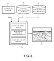
figure 3 représente le synoptique d'un système d'aide au pilotage et à la navigation selon l'invention ; - La
figure 4 représente un paysage sans représentation cartographique ; - La
figure 5 représente une représentation cartographique conforme sous forme de carroyage selon l'invention appliquée au paysage précédent. - Pour être mis en oeuvre, le procédé de représentation graphique selon l'invention nécessite un système d'aide au pilotage et à la navigation d'un véhicule. Dans son application principale, le procédé est mis en oeuvre dans un aéronef de façon à fournir au pilote la meilleure représentation possible du paysage extérieur. Le système d'aide au pilotage est le système avionique embarqué de l'appareil. De tels systèmes existent aujourd'hui sur tous les aéronefs modernes et sont connus de l'homme du métier. Ils sont également connus sous l'acronyme « SVS », signifiant « Système de Vision Synthétique ». Un tel système est représenté sur la
figure 3 . Il comporte au moins : - Un système de navigation SN permettant de déterminer la position et l'attitude de l'aéronef. A titre d'exemples, ces systèmes de navigation comportent des centrales inertielles et/ou des systèmes de type « GPS », acronyme signifiant « Global Positioning System »;
- Une base BC de données cartographiques du terrain survolé ;
- Un calculateur électronique CE permettant de faire, entre autres, du traitement de données et des calculs de représentation graphique et mettant en oeuvre le procédé d'affichage selon l'invention ;
- Un système de visualisation D comportant préférentiellement un dispositif de visualisation dit « See-Through Displays». Ces dispositifs peuvent être des écrans transparents affichant la représentation cartographique tels des écrans à cristaux liquides ou des viseurs « Tête Haute », encore appelés « Head-Up Displays » qui projettent une image collimatée de la représentation cartographique ;
- Un système d'informations météorologiques SM, les données lui étant fournies par le radar météorologique de l'appareil ou par des stations météorologiques au sol.
- Le procédé selon l'invention comporte les étapes suivantes :
- Etape 1 : Calcul, pour une position déterminée de l'aéronef, du terrain perceptible à travers le système de visualisation ;
- Etape 2 : Sélection d'une partie dudit terrain en fonction d'une distance ou d'une altitude ou d'une gamme d'altitudes ;
- Etape 3 : Calcul d'une représentation cartographique conforme tridimensionnelle de la dite partie du terrain sélectionnée ;
- Etape 4 : Affichage par le système de visualisation de la dite représentation cartographique.
- L'étape 2 est l'étape nouvelle et importante du procédé selon l'invention. La sélection du terrain sur lequel une représentation cartographique conforme est affichée se fait essentiellement sur un critère de visibilité du terrain. On affiche la représentation cartographique là où le terrain est difficilement visible ou complètement masqué.
- Dans un premier mode de sélection, on sélectionne le terrain situé au-delà de la distance de visibilité. Cette distance de visibilité peut être déterminée automatiquement à partir de données météorologiques et des conditions de vol. Elle peut être choisie par le pilote.
- Dans un second mode de sélection, le calculateur détermine l'épaisseur de la couche nuageuse à partir d'informations météorologiques. Cette couche nuageuse a une altitude minimale BN qui peut correspondre à la surface du terrain et une altitude maximale HN. L'aéronef peut se trouver sous la couche nuageuse. Dans ce cas, le terrain sélectionné se situe au-dessus de l'altitude minimale BN. L'aéronef peut se trouver dans la couche nuageuse. Dans ce cas, tout le terrain est sélectionné. L'aéronef peut se situer au-dessus de la couche nuageuse. Dans ce dernier cas, le terrain sélectionné est situé en dessous d'une altitude maximale HN.
- Dans un troisième mode ce sélection, la sélection du terrain est réalisée automatiquement à partir d'informations météorologiques par le calculateur.
- Une fois la sélection du terrain effectuée, le calculateur calcule une représentation cartographique conforme tridimensionnelle de la dite partie du terrain sélectionnée. A titre d'exemple, cette représentation est un carroyage, le terrain étant représenté sous forme d'une projection de carreaux réguliers qui épousent la forme du terrain. Il existe de nombreuses variantes à cette première représentation, comme la représentation des lignes de crêtes.
- Les
figures 4 et 5 représentent une illustration du procédé selon l'invention. Elles représentent, avec les contraintes inhérentes aux figures de brevet, un paysage vu à travers l'écran semi-transparent d'un système de visualisation. On aperçoit une montagne au premier plan à droite de lafigure 4 et une couche nuageuse qui masque tout l'arrière du paysage. La montagne est représentée en traits pointillés et la couche nuageuse est représentée en blanc sur lafigure 4 . L'aéronef se situe au-dessus de la couche nuageuse et la partie du terrain située dessous est invisible. Les données météorologiques permettent de connaître l'altitude maximale de cette couche nuageuse. Dans ce cas, le calculateur calcule la représentation cartographique du terrain masqué par la couche nuageuse et l'affiche sur l'écran. - Dans le cas de la
figure 5 , cet affichage est fait sous forme d'un carroyage représenté en traits noirs sur le fond blanc de la couche nuageuse. Dans l'image réelle, le carroyage est représenté en traits colorés lumineux, généralement monochromes. La luminance des traits est choisie suffisante pour que le carroyage soit bien visible sur le fond des nuages. - Le pilote peut ainsi apprécier les éléments de terrain dissimulés par la couche de nuages sans surcharger inutilement les éléments au premier plan clairement visibles.
Claims (6)
- Procédé de représentation synthétique tridimensionnelle conforme d'un terrain, ledit procédé étant mis en oeuvre dans un système d'aide au pilotage et à la navigation d'un aéronef, ledit système d'aide comprenant au moins un système de navigation (SN), une base de données cartographiques (BC), des moyens de calcul électronique (CE) et un système de visualisation (D) permettant la superposition d'images synthétiques sur l'extérieur, caractérisé en ce que ledit procédé comporte les étapes suivantes :Etape 1 : Calcul, pour une position déterminée du véhicule, du terrain perceptible à travers le système de visualisation ;Etape 2 : Sélection d'une partie dudit terrain en fonction d'une distance ou d'une altitude ou d'une gamme d'altitudes ;Etape 3 : Calcul d'une représentation cartographique (C) conforme tridimensionnelle de la dite partie du terrain sélectionnée ;Etape 4 : Affichage par le système de visualisation de la dite représentation cartographique.
- Procédé de représentation d'un terrain selon la revendication 1, caractérisé en ce que la représentation cartographique conforme est calculée pour une partie du terrain située sous une altitude maximale et/ou au dessus d'une altitude minimale.
- Procédé de représentation d'un terrain selon la revendication 1, caractérisé en ce que la représentation cartographique conforme est calculée pour une partie du terrain située à partir d'une distance minimale.
- Procédé de représentation d'un terrain selon la revendication 1, caractérisé en ce que le système d'aide comprend une base de données météorologiques (SM) comportant au moins les altitudes de la base et du sommet de la couche nuageuse, si elle existe, au dessus du terrain perceptible à travers le système de visualisation, la représentation cartographique conforme étant calculée pour la partie cachée du terrain située entre la base et le sommet de la couche nuageuse.
- Procédé de représentation d'un terrain selon l'une des revendications précédentes, caractérisé en ce que la représentation cartographique conforme est un carroyage (C) composé de lignes de niveaux selon deux directions perpendiculaires.
- Système d'aide au pilotage et à la navigation d'un aéronef, ledit système d'aide comprenant au moins un système de navigation, une base de données cartographiques et un système de visualisation permettant la superposition d'images synthétiques sur l'extérieur du véhicule, caractérisé en ce que ledit système comporte des moyens de calcul électroniques agencés de façon à mettre en oeuvre le procédé de représentation synthétique tridimensionnelle conforme d'un terrain selon l'une des revendications précédentes.
Applications Claiming Priority (1)
| Application Number | Priority Date | Filing Date | Title |
|---|---|---|---|
| FR1302074A FR3010516B1 (fr) | 2013-09-06 | 2013-09-06 | Procede de representation synthetique tridimensionnelle conforme d'une cartographie de terrain en fonction de la visibilite |
Publications (2)
| Publication Number | Publication Date |
|---|---|
| EP2846133A1 true EP2846133A1 (fr) | 2015-03-11 |
| EP2846133B1 EP2846133B1 (fr) | 2016-04-20 |
Family
ID=50137685
Family Applications (1)
| Application Number | Title | Priority Date | Filing Date |
|---|---|---|---|
| EP14180904.6A Active EP2846133B1 (fr) | 2013-09-06 | 2014-08-14 | Procédé de représentation synthétique tridimensionnelle conforme d'une cartographie de terrain en fonction de la visibilité |
Country Status (3)
| Country | Link |
|---|---|
| US (1) | US9557176B2 (fr) |
| EP (1) | EP2846133B1 (fr) |
| FR (1) | FR3010516B1 (fr) |
Cited By (3)
| Publication number | Priority date | Publication date | Assignee | Title |
|---|---|---|---|---|
| CN106184785A (zh) * | 2016-06-30 | 2016-12-07 | 西安电子科技大学 | 一种用于无人直升机的辅助着陆指示方法 |
| CN107168516A (zh) * | 2017-03-31 | 2017-09-15 | 浙江工业大学 | 基于vr及手势交互技术的全球气候矢量场数据可视化方法 |
| FR3090168A1 (fr) | 2018-12-17 | 2020-06-19 | Thales | Procédé d’élaboration d’une représentation tridimensionnelle d’un terrain survolé par un aéronef, produit programme d’ordinateur et dispositif électronique associés |
Families Citing this family (5)
| Publication number | Priority date | Publication date | Assignee | Title |
|---|---|---|---|---|
| FR3012618B1 (fr) * | 2013-10-30 | 2018-08-31 | Thales | Terminal d'operateur a affichage de zones de qualite de prises de vues |
| US10308371B1 (en) * | 2016-03-18 | 2019-06-04 | Rockwell Collins, Inc. | Spatially modulated and temporally sequenced multi-stream vision system |
| FR3065831B1 (fr) * | 2017-04-26 | 2019-06-28 | Thales | Procede de visualisation du trafic aux environs d'un aeronef de reference dans une zone d'affichage non-conforme, produit programme d'ordinateur et systeme de visualisation associes |
| US11151782B1 (en) * | 2018-12-18 | 2021-10-19 | B+T Group Holdings, Inc. | System and process of generating digital images of a site having a structure with superimposed intersecting grid lines and annotations |
| US20250384780A1 (en) * | 2024-06-12 | 2025-12-18 | Rockwell Collins, Inc. | Aircraft based cloud ceiling detection |
Citations (5)
| Publication number | Priority date | Publication date | Assignee | Title |
|---|---|---|---|---|
| US7098913B1 (en) | 2002-07-30 | 2006-08-29 | Rockwell Collins, Inc. | Method and system for providing depth cues by attenuating distant displayed terrain |
| US20070171094A1 (en) * | 2006-01-20 | 2007-07-26 | Keith Alter | Real-time, three-dimensional synthetic vision display of sensor-validated terrain data |
| US7262713B1 (en) * | 2004-09-30 | 2007-08-28 | Rockwell Collins, Inc. | System and method for a safe depiction of terrain, airport and other dimensional data on a perspective flight display with limited bandwidth of data presentation |
| US8049644B1 (en) * | 2007-04-17 | 2011-11-01 | Rcokwell Collins, Inc. | Method for TAWS depiction on SVS perspective displays |
| US8264498B1 (en) | 2008-04-01 | 2012-09-11 | Rockwell Collins, Inc. | System, apparatus, and method for presenting a monochrome image of terrain on a head-up display unit |
Family Cites Families (6)
| Publication number | Priority date | Publication date | Assignee | Title |
|---|---|---|---|---|
| US8185301B1 (en) * | 2006-07-26 | 2012-05-22 | Honeywell International Inc. | Aircraft traffic awareness system and methods |
| US8232910B1 (en) * | 2007-08-31 | 2012-07-31 | Rockwell Collins, Inc. | RTAWS active tower hazard detection system |
| US7825831B2 (en) * | 2007-11-14 | 2010-11-02 | Universal Avionics Systems Corp. | Aircraft flight display with a non-linear pitch scale |
| FR2935793B1 (fr) * | 2008-09-05 | 2010-12-10 | Thales Sa | Dispositif de visualisation pour aeronef comprenant des moyens d'affichage de la destination finale et procede d'affichage associe |
| FR2935824B1 (fr) * | 2008-09-09 | 2010-09-03 | Thales Sa | Dispositif de visualisation pour aeronef comprenant des moyens d'affichage d'aeronefs presentant un risque de collision |
| US9146132B2 (en) * | 2008-09-29 | 2015-09-29 | Honeywell International Inc. | Systems and methods for displaying images of terrain data |
-
2013
- 2013-09-06 FR FR1302074A patent/FR3010516B1/fr not_active Expired - Fee Related
-
2014
- 2014-08-14 EP EP14180904.6A patent/EP2846133B1/fr active Active
- 2014-09-05 US US14/479,243 patent/US9557176B2/en active Active
Patent Citations (5)
| Publication number | Priority date | Publication date | Assignee | Title |
|---|---|---|---|---|
| US7098913B1 (en) | 2002-07-30 | 2006-08-29 | Rockwell Collins, Inc. | Method and system for providing depth cues by attenuating distant displayed terrain |
| US7262713B1 (en) * | 2004-09-30 | 2007-08-28 | Rockwell Collins, Inc. | System and method for a safe depiction of terrain, airport and other dimensional data on a perspective flight display with limited bandwidth of data presentation |
| US20070171094A1 (en) * | 2006-01-20 | 2007-07-26 | Keith Alter | Real-time, three-dimensional synthetic vision display of sensor-validated terrain data |
| US8049644B1 (en) * | 2007-04-17 | 2011-11-01 | Rcokwell Collins, Inc. | Method for TAWS depiction on SVS perspective displays |
| US8264498B1 (en) | 2008-04-01 | 2012-09-11 | Rockwell Collins, Inc. | System, apparatus, and method for presenting a monochrome image of terrain on a head-up display unit |
Non-Patent Citations (1)
| Title |
|---|
| BENNETT P J: "Enhanced navigation and displays from passive terrain referenced avionics", 19880523; 19880523 - 19880527, 23 May 1988 (1988-05-23), pages 209 - 216, XP010076893 * |
Cited By (5)
| Publication number | Priority date | Publication date | Assignee | Title |
|---|---|---|---|---|
| CN106184785A (zh) * | 2016-06-30 | 2016-12-07 | 西安电子科技大学 | 一种用于无人直升机的辅助着陆指示方法 |
| CN107168516A (zh) * | 2017-03-31 | 2017-09-15 | 浙江工业大学 | 基于vr及手势交互技术的全球气候矢量场数据可视化方法 |
| CN107168516B (zh) * | 2017-03-31 | 2019-10-11 | 浙江工业大学 | 基于vr及手势交互技术的全球气候矢量场数据可视化方法 |
| FR3090168A1 (fr) | 2018-12-17 | 2020-06-19 | Thales | Procédé d’élaboration d’une représentation tridimensionnelle d’un terrain survolé par un aéronef, produit programme d’ordinateur et dispositif électronique associés |
| US11386796B2 (en) | 2018-12-17 | 2022-07-12 | Thales | Method for generating a three-dimensional representation of a terrain overflown by an aircraft and associated computer program product and electronic device |
Also Published As
| Publication number | Publication date |
|---|---|
| US20150073696A1 (en) | 2015-03-12 |
| EP2846133B1 (fr) | 2016-04-20 |
| FR3010516B1 (fr) | 2015-09-25 |
| FR3010516A1 (fr) | 2015-03-13 |
| US9557176B2 (en) | 2017-01-31 |
Similar Documents
| Publication | Publication Date | Title |
|---|---|---|
| EP2846133B1 (fr) | Procédé de représentation synthétique tridimensionnelle conforme d'une cartographie de terrain en fonction de la visibilité | |
| EP2296129B1 (fr) | Dispositif et procédé d'aide à l'atterrissage avec indications aidant à la visibilité du monde extérieur | |
| US20120140070A1 (en) | Near-to-eye head display system and method | |
| EP2793070A1 (fr) | Systeme de visualisation hybride affichant des informations en superposition sur l'exterieur | |
| US9864194B2 (en) | Systems and methods for displaying FOV boundaries on HUDs | |
| FR2996670A1 (fr) | Systeme de visualisation pour aeronef, et procede de visualisation associe | |
| FR3030092A1 (fr) | Procede de representation tridimensionnelle d'une scene | |
| CA2934851A1 (fr) | Procede et systeme d'affichage de contraintes verticales d'un aeronef, produit programme d'ordinateur et aeronef associes | |
| FR3110728A1 (fr) | Dispositif électronique d'affichage de symboles exocentrés, procédé d'affichage et produit programme d'ordinateur associés | |
| FR3065831B1 (fr) | Procede de visualisation du trafic aux environs d'un aeronef de reference dans une zone d'affichage non-conforme, produit programme d'ordinateur et systeme de visualisation associes | |
| FR3046282A1 (fr) | Procede de representation graphique d'une image issue d'un capteur d'image en superposition sur une seconde image synthetique du paysage exterieur | |
| EP4198947A1 (fr) | Procédé d'identification d'une zone de poser, programme d ordinateur et dispositif électronique associés | |
| FR3057685B1 (fr) | Procede de designation et d'affichage d'informations dans un systeme de visualisation comportant une pluralite d'ecrans | |
| FR3020457B1 (fr) | Procede d'affichage des attitudes d'un aeronef en vol et systeme de visualisation associe | |
| FR3018119A1 (fr) | Systeme de visualisation de casque comportant des moyens d'affichage et de gestion de documentation | |
| EP3029420B1 (fr) | Systeme de visualisation synthetique comprenant des moyens d'adaptation du paysage affiche | |
| EP3187829B1 (fr) | Procede de representation graphique d'une vue synthetique tridimensionnelle du paysage exterieur dans un systeme de visualisation de bord pour aeronef | |
| FR3009414A1 (fr) | Procede de representation synthetique tridimensionnelle conforme d'une cartographie de terrain | |
| CN107591031B (zh) | 自动调整外部景观的三维合成表示中的可见范围的方法 | |
| FR3090168A1 (fr) | Procédé d’élaboration d’une représentation tridimensionnelle d’un terrain survolé par un aéronef, produit programme d’ordinateur et dispositif électronique associés | |
| WO2007065806A1 (fr) | Procede de synthese d'images d'intervisibilite | |
| EP3184966A1 (fr) | Procede de representation graphique tridimensionnelle d'un axe de piste d'atterrissage | |
| FR3071624B1 (fr) | Systeme d'affichage, procede d'affichage et programme d'ordinateur associes | |
| FR3037645A1 (fr) | Systeme de visualisation comportant une representation graphique des distances dans une vue cartographique en perspective et procede associe | |
| EP3018450B1 (fr) | Procede de representation d'une image cartographique dans un systeme de visualisation geolocalise prenant en compte la precision de geolocalisation |
Legal Events
| Date | Code | Title | Description |
|---|---|---|---|
| 17P | Request for examination filed |
Effective date: 20140814 |
|
| AK | Designated contracting states |
Kind code of ref document: A1 Designated state(s): AL AT BE BG CH CY CZ DE DK EE ES FI FR GB GR HR HU IE IS IT LI LT LU LV MC MK MT NL NO PL PT RO RS SE SI SK SM TR |
|
| AX | Request for extension of the european patent |
Extension state: BA ME |
|
| PUAI | Public reference made under article 153(3) epc to a published international application that has entered the european phase |
Free format text: ORIGINAL CODE: 0009012 |
|
| R17P | Request for examination filed (corrected) |
Effective date: 20150826 |
|
| RBV | Designated contracting states (corrected) |
Designated state(s): AL AT BE BG CH CY CZ DE DK EE ES FI FR GB GR HR HU IE IS IT LI LT LU LV MC MK MT NL NO PL PT RO RS SE SI SK SM TR |
|
| GRAP | Despatch of communication of intention to grant a patent |
Free format text: ORIGINAL CODE: EPIDOSNIGR1 |
|
| RIC1 | Information provided on ipc code assigned before grant |
Ipc: G01C 21/20 20060101ALI20151008BHEP Ipc: G01C 23/00 20060101AFI20151008BHEP Ipc: G06T 17/05 20110101ALI20151008BHEP |
|
| INTG | Intention to grant announced |
Effective date: 20151103 |
|
| GRAS | Grant fee paid |
Free format text: ORIGINAL CODE: EPIDOSNIGR3 |
|
| GRAA | (expected) grant |
Free format text: ORIGINAL CODE: 0009210 |
|
| RAP1 | Party data changed (applicant data changed or rights of an application transferred) |
Owner name: THALES |
|
| AK | Designated contracting states |
Kind code of ref document: B1 Designated state(s): AL AT BE BG CH CY CZ DE DK EE ES FI FR GB GR HR HU IE IS IT LI LT LU LV MC MK MT NL NO PL PT RO RS SE SI SK SM TR |
|
| REG | Reference to a national code |
Ref country code: GB Ref legal event code: FG4D Free format text: NOT ENGLISH |
|
| REG | Reference to a national code |
Ref country code: CH Ref legal event code: EP |
|
| REG | Reference to a national code |
Ref country code: AT Ref legal event code: REF Ref document number: 792951 Country of ref document: AT Kind code of ref document: T Effective date: 20160515 |
|
| REG | Reference to a national code |
Ref country code: IE Ref legal event code: FG4D Free format text: LANGUAGE OF EP DOCUMENT: FRENCH |
|
| REG | Reference to a national code |
Ref country code: DE Ref legal event code: R096 Ref document number: 602014001567 Country of ref document: DE |
|
| REG | Reference to a national code |
Ref country code: FR Ref legal event code: PLFP Year of fee payment: 3 |
|
| REG | Reference to a national code |
Ref country code: LT Ref legal event code: MG4D |
|
| REG | Reference to a national code |
Ref country code: AT Ref legal event code: MK05 Ref document number: 792951 Country of ref document: AT Kind code of ref document: T Effective date: 20160420 |
|
| REG | Reference to a national code |
Ref country code: NL Ref legal event code: MP Effective date: 20160420 |
|
| PG25 | Lapsed in a contracting state [announced via postgrant information from national office to epo] |
Ref country code: NO Free format text: LAPSE BECAUSE OF FAILURE TO SUBMIT A TRANSLATION OF THE DESCRIPTION OR TO PAY THE FEE WITHIN THE PRESCRIBED TIME-LIMIT Effective date: 20160720 Ref country code: NL Free format text: LAPSE BECAUSE OF FAILURE TO SUBMIT A TRANSLATION OF THE DESCRIPTION OR TO PAY THE FEE WITHIN THE PRESCRIBED TIME-LIMIT Effective date: 20160420 Ref country code: PL Free format text: LAPSE BECAUSE OF FAILURE TO SUBMIT A TRANSLATION OF THE DESCRIPTION OR TO PAY THE FEE WITHIN THE PRESCRIBED TIME-LIMIT Effective date: 20160420 Ref country code: FI Free format text: LAPSE BECAUSE OF FAILURE TO SUBMIT A TRANSLATION OF THE DESCRIPTION OR TO PAY THE FEE WITHIN THE PRESCRIBED TIME-LIMIT Effective date: 20160420 Ref country code: LT Free format text: LAPSE BECAUSE OF FAILURE TO SUBMIT A TRANSLATION OF THE DESCRIPTION OR TO PAY THE FEE WITHIN THE PRESCRIBED TIME-LIMIT Effective date: 20160420 |
|
| PG25 | Lapsed in a contracting state [announced via postgrant information from national office to epo] |
Ref country code: GR Free format text: LAPSE BECAUSE OF FAILURE TO SUBMIT A TRANSLATION OF THE DESCRIPTION OR TO PAY THE FEE WITHIN THE PRESCRIBED TIME-LIMIT Effective date: 20160721 Ref country code: PT Free format text: LAPSE BECAUSE OF FAILURE TO SUBMIT A TRANSLATION OF THE DESCRIPTION OR TO PAY THE FEE WITHIN THE PRESCRIBED TIME-LIMIT Effective date: 20160822 Ref country code: LV Free format text: LAPSE BECAUSE OF FAILURE TO SUBMIT A TRANSLATION OF THE DESCRIPTION OR TO PAY THE FEE WITHIN THE PRESCRIBED TIME-LIMIT Effective date: 20160420 Ref country code: SE Free format text: LAPSE BECAUSE OF FAILURE TO SUBMIT A TRANSLATION OF THE DESCRIPTION OR TO PAY THE FEE WITHIN THE PRESCRIBED TIME-LIMIT Effective date: 20160420 Ref country code: RS Free format text: LAPSE BECAUSE OF FAILURE TO SUBMIT A TRANSLATION OF THE DESCRIPTION OR TO PAY THE FEE WITHIN THE PRESCRIBED TIME-LIMIT Effective date: 20160420 Ref country code: AT Free format text: LAPSE BECAUSE OF FAILURE TO SUBMIT A TRANSLATION OF THE DESCRIPTION OR TO PAY THE FEE WITHIN THE PRESCRIBED TIME-LIMIT Effective date: 20160420 Ref country code: HR Free format text: LAPSE BECAUSE OF FAILURE TO SUBMIT A TRANSLATION OF THE DESCRIPTION OR TO PAY THE FEE WITHIN THE PRESCRIBED TIME-LIMIT Effective date: 20160420 Ref country code: ES Free format text: LAPSE BECAUSE OF FAILURE TO SUBMIT A TRANSLATION OF THE DESCRIPTION OR TO PAY THE FEE WITHIN THE PRESCRIBED TIME-LIMIT Effective date: 20160420 |
|
| PG25 | Lapsed in a contracting state [announced via postgrant information from national office to epo] |
Ref country code: BE Free format text: LAPSE BECAUSE OF NON-PAYMENT OF DUE FEES Effective date: 20160831 Ref country code: IT Free format text: LAPSE BECAUSE OF FAILURE TO SUBMIT A TRANSLATION OF THE DESCRIPTION OR TO PAY THE FEE WITHIN THE PRESCRIBED TIME-LIMIT Effective date: 20160420 |
|
| REG | Reference to a national code |
Ref country code: DE Ref legal event code: R097 Ref document number: 602014001567 Country of ref document: DE |
|
| PG25 | Lapsed in a contracting state [announced via postgrant information from national office to epo] |
Ref country code: SK Free format text: LAPSE BECAUSE OF FAILURE TO SUBMIT A TRANSLATION OF THE DESCRIPTION OR TO PAY THE FEE WITHIN THE PRESCRIBED TIME-LIMIT Effective date: 20160420 Ref country code: DK Free format text: LAPSE BECAUSE OF FAILURE TO SUBMIT A TRANSLATION OF THE DESCRIPTION OR TO PAY THE FEE WITHIN THE PRESCRIBED TIME-LIMIT Effective date: 20160420 Ref country code: EE Free format text: LAPSE BECAUSE OF FAILURE TO SUBMIT A TRANSLATION OF THE DESCRIPTION OR TO PAY THE FEE WITHIN THE PRESCRIBED TIME-LIMIT Effective date: 20160420 Ref country code: RO Free format text: LAPSE BECAUSE OF FAILURE TO SUBMIT A TRANSLATION OF THE DESCRIPTION OR TO PAY THE FEE WITHIN THE PRESCRIBED TIME-LIMIT Effective date: 20160420 Ref country code: CZ Free format text: LAPSE BECAUSE OF FAILURE TO SUBMIT A TRANSLATION OF THE DESCRIPTION OR TO PAY THE FEE WITHIN THE PRESCRIBED TIME-LIMIT Effective date: 20160420 |
|
| PLBE | No opposition filed within time limit |
Free format text: ORIGINAL CODE: 0009261 |
|
| STAA | Information on the status of an ep patent application or granted ep patent |
Free format text: STATUS: NO OPPOSITION FILED WITHIN TIME LIMIT |
|
| PG25 | Lapsed in a contracting state [announced via postgrant information from national office to epo] |
Ref country code: SM Free format text: LAPSE BECAUSE OF FAILURE TO SUBMIT A TRANSLATION OF THE DESCRIPTION OR TO PAY THE FEE WITHIN THE PRESCRIBED TIME-LIMIT Effective date: 20160420 |
|
| 26N | No opposition filed |
Effective date: 20170123 |
|
| PG25 | Lapsed in a contracting state [announced via postgrant information from national office to epo] |
Ref country code: MC Free format text: LAPSE BECAUSE OF FAILURE TO SUBMIT A TRANSLATION OF THE DESCRIPTION OR TO PAY THE FEE WITHIN THE PRESCRIBED TIME-LIMIT Effective date: 20160420 |
|
| PG25 | Lapsed in a contracting state [announced via postgrant information from national office to epo] |
Ref country code: SI Free format text: LAPSE BECAUSE OF FAILURE TO SUBMIT A TRANSLATION OF THE DESCRIPTION OR TO PAY THE FEE WITHIN THE PRESCRIBED TIME-LIMIT Effective date: 20160420 |
|
| REG | Reference to a national code |
Ref country code: IE Ref legal event code: MM4A |
|
| REG | Reference to a national code |
Ref country code: FR Ref legal event code: PLFP Year of fee payment: 4 |
|
| PG25 | Lapsed in a contracting state [announced via postgrant information from national office to epo] |
Ref country code: IE Free format text: LAPSE BECAUSE OF NON-PAYMENT OF DUE FEES Effective date: 20160814 |
|
| PG25 | Lapsed in a contracting state [announced via postgrant information from national office to epo] |
Ref country code: LU Free format text: LAPSE BECAUSE OF NON-PAYMENT OF DUE FEES Effective date: 20160814 |
|
| REG | Reference to a national code |
Ref country code: CH Ref legal event code: PL |
|
| PG25 | Lapsed in a contracting state [announced via postgrant information from national office to epo] |
Ref country code: CH Free format text: LAPSE BECAUSE OF NON-PAYMENT OF DUE FEES Effective date: 20170831 Ref country code: LI Free format text: LAPSE BECAUSE OF NON-PAYMENT OF DUE FEES Effective date: 20170831 |
|
| PG25 | Lapsed in a contracting state [announced via postgrant information from national office to epo] |
Ref country code: HU Free format text: LAPSE BECAUSE OF FAILURE TO SUBMIT A TRANSLATION OF THE DESCRIPTION OR TO PAY THE FEE WITHIN THE PRESCRIBED TIME-LIMIT; INVALID AB INITIO Effective date: 20140814 |
|
| PG25 | Lapsed in a contracting state [announced via postgrant information from national office to epo] |
Ref country code: MK Free format text: LAPSE BECAUSE OF FAILURE TO SUBMIT A TRANSLATION OF THE DESCRIPTION OR TO PAY THE FEE WITHIN THE PRESCRIBED TIME-LIMIT Effective date: 20160420 Ref country code: CY Free format text: LAPSE BECAUSE OF FAILURE TO SUBMIT A TRANSLATION OF THE DESCRIPTION OR TO PAY THE FEE WITHIN THE PRESCRIBED TIME-LIMIT Effective date: 20160420 Ref country code: IS Free format text: LAPSE BECAUSE OF FAILURE TO SUBMIT A TRANSLATION OF THE DESCRIPTION OR TO PAY THE FEE WITHIN THE PRESCRIBED TIME-LIMIT Effective date: 20160420 Ref country code: MT Free format text: LAPSE BECAUSE OF FAILURE TO SUBMIT A TRANSLATION OF THE DESCRIPTION OR TO PAY THE FEE WITHIN THE PRESCRIBED TIME-LIMIT Effective date: 20160420 |
|
| REG | Reference to a national code |
Ref country code: FR Ref legal event code: PLFP Year of fee payment: 5 |
|
| PG25 | Lapsed in a contracting state [announced via postgrant information from national office to epo] |
Ref country code: BG Free format text: LAPSE BECAUSE OF FAILURE TO SUBMIT A TRANSLATION OF THE DESCRIPTION OR TO PAY THE FEE WITHIN THE PRESCRIBED TIME-LIMIT Effective date: 20160420 |
|
| PG25 | Lapsed in a contracting state [announced via postgrant information from national office to epo] |
Ref country code: TR Free format text: LAPSE BECAUSE OF FAILURE TO SUBMIT A TRANSLATION OF THE DESCRIPTION OR TO PAY THE FEE WITHIN THE PRESCRIBED TIME-LIMIT Effective date: 20160420 Ref country code: AL Free format text: LAPSE BECAUSE OF FAILURE TO SUBMIT A TRANSLATION OF THE DESCRIPTION OR TO PAY THE FEE WITHIN THE PRESCRIBED TIME-LIMIT Effective date: 20160420 |
|
| P01 | Opt-out of the competence of the unified patent court (upc) registered |
Effective date: 20230427 |
|
| PGFP | Annual fee paid to national office [announced via postgrant information from national office to epo] |
Ref country code: DE Payment date: 20250716 Year of fee payment: 12 |
|
| PGFP | Annual fee paid to national office [announced via postgrant information from national office to epo] |
Ref country code: GB Payment date: 20250717 Year of fee payment: 12 |
|
| PGFP | Annual fee paid to national office [announced via postgrant information from national office to epo] |
Ref country code: FR Payment date: 20250721 Year of fee payment: 12 |