EP2690409A2 - Procédé permettant d'afficher le caractère approprié d'emplacements de points de cheminement futurs - Google Patents
Procédé permettant d'afficher le caractère approprié d'emplacements de points de cheminement futurs Download PDFInfo
- Publication number
- EP2690409A2 EP2690409A2 EP13177956.3A EP13177956A EP2690409A2 EP 2690409 A2 EP2690409 A2 EP 2690409A2 EP 13177956 A EP13177956 A EP 13177956A EP 2690409 A2 EP2690409 A2 EP 2690409A2
- Authority
- EP
- European Patent Office
- Prior art keywords
- waypoint
- indicia
- future
- aircraft
- placement
- Prior art date
- Legal status (The legal status is an assumption and is not a legal conclusion. Google has not performed a legal analysis and makes no representation as to the accuracy of the status listed.)
- Granted
Links
- 238000000034 method Methods 0.000 title claims abstract description 44
- 230000006870 function Effects 0.000 description 2
- 238000004422 calculation algorithm Methods 0.000 description 1
- 238000004364 calculation method Methods 0.000 description 1
- 238000004590 computer program Methods 0.000 description 1
- 230000008014 freezing Effects 0.000 description 1
- 238000007710 freezing Methods 0.000 description 1
- 238000001556 precipitation Methods 0.000 description 1
- 230000035899 viability Effects 0.000 description 1
- 230000000007 visual effect Effects 0.000 description 1
Images


Classifications
-
- G—PHYSICS
- G01—MEASURING; TESTING
- G01C—MEASURING DISTANCES, LEVELS OR BEARINGS; SURVEYING; NAVIGATION; GYROSCOPIC INSTRUMENTS; PHOTOGRAMMETRY OR VIDEOGRAMMETRY
- G01C23/00—Combined instruments indicating more than one navigational value, e.g. for aircraft; Combined measuring devices for measuring two or more variables of movement, e.g. distance, speed or acceleration
- G01C23/005—Flight directors
-
- G—PHYSICS
- G01—MEASURING; TESTING
- G01C—MEASURING DISTANCES, LEVELS OR BEARINGS; SURVEYING; NAVIGATION; GYROSCOPIC INSTRUMENTS; PHOTOGRAMMETRY OR VIDEOGRAMMETRY
- G01C21/00—Navigation; Navigational instruments not provided for in groups G01C1/00 - G01C19/00
- G01C21/20—Instruments for performing navigational calculations
-
- G—PHYSICS
- G08—SIGNALLING
- G08G—TRAFFIC CONTROL SYSTEMS
- G08G5/00—Traffic control systems for aircraft, e.g. air-traffic control [ATC]
- G08G5/0017—Arrangements for implementing traffic-related aircraft activities, e.g. arrangements for generating, displaying, acquiring or managing traffic information
- G08G5/0021—Arrangements for implementing traffic-related aircraft activities, e.g. arrangements for generating, displaying, acquiring or managing traffic information located in the aircraft
-
- G—PHYSICS
- G08—SIGNALLING
- G08G—TRAFFIC CONTROL SYSTEMS
- G08G5/00—Traffic control systems for aircraft, e.g. air-traffic control [ATC]
- G08G5/003—Flight plan management
- G08G5/0034—Assembly of a flight plan
-
- G—PHYSICS
- G08—SIGNALLING
- G08G—TRAFFIC CONTROL SYSTEMS
- G08G5/00—Traffic control systems for aircraft, e.g. air-traffic control [ATC]
- G08G5/0073—Surveillance aids
- G08G5/0078—Surveillance aids for monitoring traffic from the aircraft
-
- G—PHYSICS
- G08—SIGNALLING
- G08G—TRAFFIC CONTROL SYSTEMS
- G08G5/00—Traffic control systems for aircraft, e.g. air-traffic control [ATC]
- G08G5/0073—Surveillance aids
- G08G5/0086—Surveillance aids for monitoring terrain
-
- G—PHYSICS
- G08—SIGNALLING
- G08G—TRAFFIC CONTROL SYSTEMS
- G08G5/00—Traffic control systems for aircraft, e.g. air-traffic control [ATC]
- G08G5/0073—Surveillance aids
- G08G5/0091—Surveillance aids for monitoring atmospheric conditions
-
- G—PHYSICS
- G01—MEASURING; TESTING
- G01C—MEASURING DISTANCES, LEVELS OR BEARINGS; SURVEYING; NAVIGATION; GYROSCOPIC INSTRUMENTS; PHOTOGRAMMETRY OR VIDEOGRAMMETRY
- G01C21/00—Navigation; Navigational instruments not provided for in groups G01C1/00 - G01C19/00
- G01C21/26—Navigation; Navigational instruments not provided for in groups G01C1/00 - G01C19/00 specially adapted for navigation in a road network
- G01C21/34—Route searching; Route guidance
-
- G—PHYSICS
- G06—COMPUTING; CALCULATING OR COUNTING
- G06F—ELECTRIC DIGITAL DATA PROCESSING
- G06F16/00—Information retrieval; Database structures therefor; File system structures therefor
-
- G—PHYSICS
- G08—SIGNALLING
- G08G—TRAFFIC CONTROL SYSTEMS
- G08G1/00—Traffic control systems for road vehicles
- G08G1/07—Controlling traffic signals
- G08G1/087—Override of traffic control, e.g. by signal transmitted by an emergency vehicle
-
- G—PHYSICS
- G16—INFORMATION AND COMMUNICATION TECHNOLOGY [ICT] SPECIALLY ADAPTED FOR SPECIFIC APPLICATION FIELDS
- G16Z—INFORMATION AND COMMUNICATION TECHNOLOGY [ICT] SPECIALLY ADAPTED FOR SPECIFIC APPLICATION FIELDS, NOT OTHERWISE PROVIDED FOR
- G16Z99/00—Subject matter not provided for in other main groups of this subclass
Definitions
- Contemporary aircraft may include a flight management system (FMS).
- FMS flight management system
- the FMS automates a wide variety of in-flight tasks and one of its primary functions is in-flight management of the flight plan.
- the flight plan may be modeled as a trajectory that can be comprised of a plurality of waypoints.
- the FMS may be capable of receiving input from a pilot regarding such waypoints but the pilot receives no information related to whether the waypoint added is viable or how the waypoint added may affect future waypoint selections for flight by the aircraft.
- the invention relates to a method of illustrating an aircraft flight plan includes displaying on the display a waypoint of the flight plan on a map and displaying on the display indicia, relative to the map, of suitable locations for a future waypoint based on the displayed waypoint.
- Figure 1 illustrates a portion of an aircraft 10 having a cockpit 12. While a commercial aircraft has been illustrated, it is contemplated that embodiments of the invention may be used in any type of aircraft allowing for a flight plan to be selected and displayed.
- a first user e.g., a pilot
- another user e.g., a co-pilot
- a cockpit instrument panel or flight deck 18 having various instruments 20 and multiple multifunction flight displays 22 may be located in front of the pilot and co-pilot and may provide the flight crew with information to aid in flying the aircraft 10.
- the flight displays 22 may include either primary flight displays or multi-function displays and may display a wide range of aircraft, flight, navigation, and other information used in the operation and control of the aircraft 10.
- the flight displays 22 may be capable of displaying color graphics and text to a user.
- the flight displays 22 may be laid out in any manner including having fewer or more displays and need not be coplanar or the same size.
- a touch screen display or touch screen surface 24 may be included in the flight display 22 and may be used by one or more flight crew members, including the pilot and co-pilot, to interact with the systems of the aircraft 10. It is contemplated that one or more cursor control devices 26, such as a mouse, and one or more multifunction keyboards 28 may be included in the cockpit 12 and may also be used by one or more flight crew members to interact with the systems of the aircraft 10.
- a controller 30 may be operably coupled to components of the aircraft 10 including the flight displays 22, touch screen surface 24, cursor control devices 26, and keyboards 28.
- the controller 30 may also be connected with other controllers (not shown) of the aircraft 10.
- the controller 30 may include memory, the memory may include random access memory (RAM), read-only memory (ROM), flash memory, or one or more different types of portable electronic memory, such as discs, DVDs, CD-ROMs, etc., or any suitable combination of these types of memory.
- the controller 30 may include processing units, which may be running any suitable programs to implement a graphical user interface (GUI) and operating system.
- GUI graphical user interface
- These programs typically include a device driver that allows the user to perform functions on the touch screen surface 24 such as selecting options, inputting commands and other data, selecting and opening files, and moving icons through the touch screen surface 24.
- the controller 30 may be a portion of an FMS or may be operably coupled to the FMS.
- the controller 30 may include a processor 32 and memory 34.
- a computer searchable database of information may be stored in the memory 34 and accessible by processor 32.
- the processor 32 may run a set of executable instructions to display the database or access the database.
- the controller 30 may be operably coupled to a database of information.
- a database may be stored on an alternative computer or controller.
- the database may be any suitable database, including a single database having multiple sets of data, multiple discrete databases linked together, or even a simple table of data.
- the database may store imagery data that may include geo-specific terrain, man-made objects including runway and airport layouts, and additional imagery including aircraft traffic information. It is contemplated that the database may incorporate a number of databases or that the database may actually be a number of separate databases including a terrain data base, man-made obstacle database, geo-political database, hydrological database, and other databases. It is contemplated that the controller 30 retrieves and displays an image on the display by generating an image from the information and imagery data obtained from the multiple databases.
- the database may also include runway data, aircraft performance data, engine performance data, current weather conditions, and historical performance data. This data may be stored as performance attributes of the aircraft, geographic constraints, and weather constraints.
- the database may be separate from the controller but may be in communication with the controller 30 such that it may be accessed by either the controller 30.
- the database may be contained on a portable memory device and in such a case, the flight deck 18 may include a port for receiving the portable memory device and such a port would be in electronic communication with controller 30 such that controller 30 may be able to read the contents of the portable memory device.
- the database may be updated through a communication link and that in this manner real time information such as information regarding air traffic imagery may be included in the database and may be included in image displayed by the controller 30.
- such a database may be located off the aircraft 10 at a location such as airline or flight operations department control (not shown) or another location and that the controller 30 may be operably coupled to a wireless network (not shown) over which the database information may be provided to the controller 30.
- the weather data may be obtained from a weather database which may contain real-time weather data or forecasted weather data.
- weather databases may contain information regarding certain weather-related phenomena (e.g., wind speed, wind direction, temperature, among others) and data pertaining to visibility (e.g., foggy, cloudy, etc.), precipitation (rain, hail, snow, freezing rain, etc.) and other meteorological information.
- the weather database may include 3-D real-time temperature and wind models of the local airspace as well as 4-D forecasted data.
- the weather database may store such real-time or forecasted weather data based at a specific latitude, longitude, and altitude.
- the controller 30 may utilize inputs from the pilot, the database, and/or information from airline control or flight operations department to present a graphical depiction of the surrounding of the aircraft 10 or a future surrounding of the aircraft 10 based on waypoint or flight plan information.
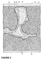
- a map 40 may be displayed on the flight display 22. It will be understood that the map 40 may be graphically illustrated in a variety of ways and that various objects, such as the runway, may be illustrated on the flight display 22 to better aid the pilot in making decisions. Further, the map 40 may take any variety of forms including a 2D map, a 3D map, a topographical map, etc.
- Portions of the flight plan including a waypoint 42 may be displayed on the map 40. Further, a current location of the aircraft 10 and/or a current trajectory of the aircraft 10 may be determined and the map 40 or the waypoint 42 may be based thereon. Indicia such as the indicia 50 may be displayed on the flight display 22, relative to the map 40. The indicia 50 may include indicia of suitable locations for a future waypoint based on the displayed waypoint 42.
- the suitability of future waypoint placement may be determined by the controller 30 based on at least one of weather, terrain, fixed obstacles, variable obstacles, and flight characteristics or performance attributes of the aircraft.
- the controller 30 may generate the indicia to be displayed on the flight display 22 taking into account such information.
- Embodiments of the invention may use a database of terrain, weather, and additional information to evaluate suitable locations for future waypoint placement.
- the controller 30 may determine the indicia based on the displayed waypoint 42 and at least one prior waypoint in the flight plan even if such prior waypoint is not illustrated on the flight display 22.
- the prior waypoint may be a user selected waypoint, a waypoint uploaded from the FMS or airline operations center, the prior waypoint may also include a current location of the aircraft 10. More specifically, the information related to both the displayed waypoint 42 and the prior waypoint may be utilized by the controller 30 to determine the suitability of future waypoint placement.
- the prior waypoint information may give additional information to the controller 30 to work with related to the heading of the aircraft 10 with respect to the displayed waypoint. More specifically, the controller 30 uses such information in determining the suitability of locations for future waypoint placement.
- the controller 30 may determine suitability of a future waypoint location by determining if aircraft or airspace parameters would be exceeded if the aircraft 10 traveled the flight plan including the future waypoint.
- a pilot's or airline's constraints may also be considered by the controller 30 in determining the suitability of locations for future waypoint placement and generating the indicia.
- a pilot's flight preferences may be one type of constraint. If the pilot prefers not to fly within a certain range of a mountain, then the controller 30 may utilize such information in determining the suitability of locations for future waypoint placement and generating the indicia. If the constraints would be exceeded for a particular location, then the indicia may indicate that such location is unsuitable.
- the information or one or more constraints may be converted to an algorithm, which may be converted to a computer program comprising a set of executable instructions, which may be executed by the controller 30, which has access to the waypoints entered into the FMS.
- one or more particular waypoints may be compared to the constraints and a determination may be made if the waypoint satisfies the constraints. If so, the waypoint may be considered suitable.
- the displayed indicia may define at least one potential area for future waypoint placement.
- the display indicium outlines multiple potential areas for future waypoint placement.
- a first potential area for future waypoint placement has been outlined as indicia 50.
- the indicia 50 of the first potential area may indicate that future waypoint placement therein is allowed.
- the second potential area for future waypoint placement has been outlined as indicia 60.
- the indicia 60 of the second potential area may indicate that while such a location is capable of being selected for future waypoint placement, the pilot may not want to select such a location for a waypoint.
- the location may be within a storm front, may intersect with flight plans of other aircraft in the area, may require a steep bank of the aircraft 10, may fall within specialized airspace, as well as other scenarios.
- the indicia 60 of the second potential area may indicate that the second potential area for future waypoint placement may require an elevation change or some other change in the operational parameters of the aircraft 10.
- the displayed indicia may include color-coded indicia to indicate the suitable locations for a future waypoint.
- red indicium may indicate a location that is not suitable for future waypoint placement and green indicium may indicate a location is suitable for future waypoint placement.
- yellow indicium may indicate a location that requires some change in the operation of the aircraft.
- the first potential area for future waypoint placement as indicated by indicia 50 includes indicia 52, which may represent a color such as green.
- the second potential area for future waypoint placement as indicated by indicia 60 includes indicia 62, which may represent a color such as yellow.
- the indicia may also be used to indicate the restrictiveness of the area for future waypoint placement.
- both the first potential area for future waypoint placement as indicated by indicia 50 and the second potential area for future waypoint placement as indicated by indicia 60 may include allowed areas for future waypoint placement.
- the indicia 50 and the indicia 60 may be differentiated by a restrictiveness of future waypoint placement.
- the indicia 50 may outline an area where future waypoint placement would be less restrictive than the area outlines by the indicia 60.
- the indicia may also indicate an area that is not suitable for future waypoint placement, such as the indicia 70.
- the indicia 70 may be generated because the area indicated by the indicia 70 may be restricted air space or the aircraft 10 may be incapable of reaching the area indicated by the indicia 70 because of terrain, weather, or the flight characteristics or performance attributes of the aircraft 10.
- Any suitable indicia may be used to indicate the unsuitable area including that the area may also be labeled as unsuitable on the flight display 22.
- the area may be greyed out or color coded, such as with the color red, to indicated the unsuitability of the area.
- the controller 30 may block out the area from future waypoint placement.
- emergency options for future waypoint placement may be indicated by indicia on the flight display 22. Such emergency options may be otherwise unsuitable for selection but may be indicated as suitable should an emergency occur.
- a user may select a waypoint, such as the illustrated waypoint 44 and that such selection may be received by the controller 30 and the controller 30 may then display such selected waypoint 44 on the flight display 22 and update the indicia based thereon. It is contemplated that the user may input the selected waypoint 44 by touching the location on the touchscreen 24 forming the flight display 22, by selecting the location using the cursor control devices 26, or by using the multifunction keyboards 28. When the waypoint is chosen, the controller 30 updates the indicia to provide the user with a visual representation of the suitability of those areas for future waypoints based upon the waypoint being entered.
- the indicia 50, 52, 60, 62, and 70 have all been updated based on the selection of the waypoint 44.
- the graphical display of the map 40 on the flight display 22 may also be updated.
- the graphical display of the map 40 may be shifted so that the pilot may see additional or alternative portions of the map 40.
- the user may select or input a waypoint and then move the waypoint with respect to the depiction on the flight display 22.
- the controller 30 may update the displayed indicia in accordance with the movement of the waypoint. This may allow the user to find the best suitable waypoint in terms of their future route choice.
- indicia may be included on the flight display 22. Further the indicia may include any number of graphical or illustrative methods while allowing the pilot to arrive at the same conclusion as to the suitability of future waypoint placement.
- the displayed information may provide the pilot foresight into what waypoints will allow them the most freedom in terms of a desired flight plan as the pilot is making the flight plan.
- the pilot is provided with waypoint information, map information, and indicia from which the pilot may assess the viability and rank the effectiveness of waypoint choices.
- Such a graphical representation may be based on the inputted waypoints as well as terrain, weather, and other information such as flight characteristics that may affect the suitability of future waypoint locations. This may allow the flight crew to recognize any issues with waypoints being selected in terms of terrain, weather, and other flight characteristics.
- the above embodiments simplify the pilot interface and allow for time savings in that the user does not have to manually account for this data in selecting a flight plan.
Landscapes
- Engineering & Computer Science (AREA)
- Radar, Positioning & Navigation (AREA)
- Remote Sensing (AREA)
- Physics & Mathematics (AREA)
- General Physics & Mathematics (AREA)
- Aviation & Aerospace Engineering (AREA)
- Life Sciences & Earth Sciences (AREA)
- Atmospheric Sciences (AREA)
- Automation & Control Theory (AREA)
- Traffic Control Systems (AREA)
- Navigation (AREA)
- Instructional Devices (AREA)
Applications Claiming Priority (1)
| Application Number | Priority Date | Filing Date | Title |
|---|---|---|---|
| US13/558,589 US9043136B2 (en) | 2012-07-26 | 2012-07-26 | Method for displaying suitability of future waypoint locations |
Publications (3)
| Publication Number | Publication Date |
|---|---|
| EP2690409A2 true EP2690409A2 (fr) | 2014-01-29 |
| EP2690409A3 EP2690409A3 (fr) | 2016-06-01 |
| EP2690409B1 EP2690409B1 (fr) | 2019-10-16 |
Family
ID=49035266
Family Applications (1)
| Application Number | Title | Priority Date | Filing Date |
|---|---|---|---|
| EP13177956.3A Active EP2690409B1 (fr) | 2012-07-26 | 2013-07-25 | Procédé permettant d'afficher le caractère approprié d'emplacements de points de cheminement futurs |
Country Status (6)
| Country | Link |
|---|---|
| US (1) | US9043136B2 (fr) |
| EP (1) | EP2690409B1 (fr) |
| JP (1) | JP2014025930A (fr) |
| CN (1) | CN103569371B (fr) |
| BR (1) | BR102013019087A2 (fr) |
| CA (1) | CA2821310C (fr) |
Families Citing this family (8)
| Publication number | Priority date | Publication date | Assignee | Title |
|---|---|---|---|---|
| US10347140B2 (en) | 2014-03-11 | 2019-07-09 | Textron Innovations Inc. | Flight planning and communication |
| US9428056B2 (en) | 2014-03-11 | 2016-08-30 | Textron Innovations, Inc. | Adjustable synthetic vision |
| US9772712B2 (en) | 2014-03-11 | 2017-09-26 | Textron Innovations, Inc. | Touch screen instrument panel |
| USD768052S1 (en) | 2015-03-05 | 2016-10-04 | Textron Innovations Inc. | Touch screen instrument panel for an aircraft cockpit |
| USD768557S1 (en) | 2015-03-05 | 2016-10-11 | Textron Innovations Inc. | Warning display for a touch screen panel in aircraft |
| CN109241465B (zh) * | 2018-07-19 | 2021-02-09 | 华为技术有限公司 | 界面显示方法、装置、终端及存储介质 |
| DE102018120675A1 (de) * | 2018-08-23 | 2020-02-27 | Autel Robotics Europe Gmbh | Verfahren, Vorrichtung und System zum Betreiben von Wegpunkt, Bodenstation und computerlesbarem Speichermedium |
| CN109375537A (zh) * | 2018-10-13 | 2019-02-22 | 南昌大学 | 一种无人机的海天实时分辨系统 |
Family Cites Families (22)
| Publication number | Priority date | Publication date | Assignee | Title |
|---|---|---|---|---|
| FR2749675B1 (fr) | 1996-06-07 | 1998-08-28 | Sextant Avionique | Procede de pilotage d'un aerodyne pour l'evitement vertical d'une zone |
| FR2789771B1 (fr) | 1999-02-12 | 2001-06-08 | Sextant Avionique | Procede pour la generation d'une trajectoire horizontale d'evitement de zones dangereuses pour un aeronef |
| US6289277B1 (en) * | 1999-10-07 | 2001-09-11 | Honeywell International Inc. | Interfaces for planning vehicle routes |
| US6691030B2 (en) * | 2001-04-02 | 2004-02-10 | Honeywell International Inc. | System and method for locating a waypoint |
| JP4507049B2 (ja) * | 2001-05-23 | 2010-07-21 | 本田技研工業株式会社 | 車両用ナビゲーションシステム |
| US6577947B1 (en) | 2002-03-01 | 2003-06-10 | Rockwell Collins, Inc. | Method and apparatus for identification of hazards along an intended travel route |
| US7848878B2 (en) | 2003-12-27 | 2010-12-07 | Electronics And Telecommunications Research Institute | Geographic information transceiving system and method thereof |
| US20100004798A1 (en) * | 2005-01-25 | 2010-01-07 | William Kress Bodin | Navigating a UAV to a next waypoint |
| US7899617B2 (en) * | 2005-02-17 | 2011-03-01 | Denso Corporation | Navigation system providing route guidance in multi-lane road according to vehicle lane position |
| US8164485B2 (en) * | 2006-04-13 | 2012-04-24 | The United States Of America As Represented By The Administrator Of The National Aeronautics And Space Administration | System and method for aiding pilot preview, rehearsal, review, and real-time visual acquisition of flight mission progress |
| US7865300B2 (en) * | 2006-11-15 | 2011-01-04 | International Business Machines Corporation | System and method for providing turn-by-turn directions to a moving waypoint |
| CN100567898C (zh) * | 2007-01-16 | 2009-12-09 | 北京航空航天大学 | 无人直升机着陆引导方法及其装置 |
| US7925393B2 (en) | 2007-08-01 | 2011-04-12 | Arinc Incorporated | Method and apparatus for generating a four-dimensional (4D) flight plan |
| US20090063032A1 (en) * | 2007-08-30 | 2009-03-05 | Honeywell International, Inc. | Methods, systems, and apparatus for routing a vehicle to avoid an adverse condition |
| FR2923008B1 (fr) | 2007-10-26 | 2010-01-08 | Thales Sa | Procede et dispositif d'affichage de previsions sur un plan de navigation |
| CN101424537B (zh) * | 2007-10-30 | 2012-02-08 | 联发科技(合肥)有限公司 | 航点代码创建方法、导航启动方法以及其相关装置 |
| US7903000B2 (en) * | 2008-04-29 | 2011-03-08 | The Boeing Company | Representing a holding pattern on a vertical situation display |
| US20100286859A1 (en) * | 2008-11-18 | 2010-11-11 | Honeywell International Inc. | Methods for generating a flight plan for an unmanned aerial vehicle based on a predicted camera path |
| US20100131126A1 (en) * | 2008-11-21 | 2010-05-27 | Honeywell International Inc. | System and display element for displaying waypoint markers with integrated altitude constraint information |
| US20100250119A1 (en) * | 2009-03-26 | 2010-09-30 | Honeywell International Inc. | Systems and methods for the display of informational waypoints |
| US8552889B2 (en) * | 2010-02-18 | 2013-10-08 | The Boeing Company | Aircraft charting system with multi-touch interaction gestures for managing a route of an aircraft |
| CN102288179B (zh) * | 2010-06-17 | 2015-06-17 | 昆达电脑科技(昆山)有限公司 | 导航系统与导航方法 |
-
2012
- 2012-07-26 US US13/558,589 patent/US9043136B2/en active Active
-
2013
- 2013-07-18 CA CA2821310A patent/CA2821310C/fr not_active Expired - Fee Related
- 2013-07-25 JP JP2013154071A patent/JP2014025930A/ja active Pending
- 2013-07-25 EP EP13177956.3A patent/EP2690409B1/fr active Active
- 2013-07-25 BR BRBR102013019087-0A patent/BR102013019087A2/pt not_active Application Discontinuation
- 2013-07-26 CN CN201310320048.6A patent/CN103569371B/zh active Active
Non-Patent Citations (1)
| Title |
|---|
| None |
Also Published As
| Publication number | Publication date |
|---|---|
| CN103569371A (zh) | 2014-02-12 |
| EP2690409B1 (fr) | 2019-10-16 |
| CA2821310A1 (fr) | 2014-01-26 |
| CN103569371B (zh) | 2018-08-07 |
| CA2821310C (fr) | 2020-08-11 |
| US20140032097A1 (en) | 2014-01-30 |
| BR102013019087A2 (pt) | 2014-12-23 |
| EP2690409A3 (fr) | 2016-06-01 |
| US9043136B2 (en) | 2015-05-26 |
| JP2014025930A (ja) | 2014-02-06 |
Similar Documents
| Publication | Publication Date | Title |
|---|---|---|
| US8965600B2 (en) | Method for displaying a flight plan | |
| US8797190B2 (en) | Method for displaying a user entered flight path | |
| EP2690613A2 (fr) | Procédé d'affichage d'un plan de vol | |
| EP2690409B1 (fr) | Procédé permettant d'afficher le caractère approprié d'emplacements de points de cheminement futurs | |
| US8412392B2 (en) | Methods and systems for displaying predicted downpath parameters in a vertical profile display | |
| US9460629B2 (en) | Flight trajectory optimization and visualization tool | |
| EP3208787A2 (fr) | Procédés et systèmes facilitant la descente stabilisée vers un aéroport de dégagement | |
| US9020664B2 (en) | Methods and systems for displaying procedure information on an aircraft display | |
| EP2741053A2 (fr) | Système et procédé de génération graphique de cours d'approche/départ | |
| EP3657131B1 (fr) | Système et procédé de présentation de liste de point de cheminement | |
| US20230249842A1 (en) | Energy constraint management methods and systems | |
| EP3104125B1 (fr) | Système et procédé de navigation d'un aéronef | |
| EP4250270A1 (fr) | Procédés et systèmes de gestion de contraintes d'énergie | |
| US11587447B2 (en) | Dynamically modifiable parameters in required time of arrival (RTA) regions of an assigned flight path | |
| BR102013018346A2 (pt) | Método para selecionar e exibir uma rota de voo para uma aeronave em um visor de uma cabine de voo da aeronave |
Legal Events
| Date | Code | Title | Description |
|---|---|---|---|
| PUAI | Public reference made under article 153(3) epc to a published international application that has entered the european phase |
Free format text: ORIGINAL CODE: 0009012 |
|
| AK | Designated contracting states |
Kind code of ref document: A2 Designated state(s): AL AT BE BG CH CY CZ DE DK EE ES FI FR GB GR HR HU IE IS IT LI LT LU LV MC MK MT NL NO PL PT RO RS SE SI SK SM TR |
|
| AX | Request for extension of the european patent |
Extension state: BA ME |
|
| PUAL | Search report despatched |
Free format text: ORIGINAL CODE: 0009013 |
|
| AK | Designated contracting states |
Kind code of ref document: A3 Designated state(s): AL AT BE BG CH CY CZ DE DK EE ES FI FR GB GR HR HU IE IS IT LI LT LU LV MC MK MT NL NO PL PT RO RS SE SI SK SM TR |
|
| AX | Request for extension of the european patent |
Extension state: BA ME |
|
| RIC1 | Information provided on ipc code assigned before grant |
Ipc: G08G 1/087 20060101ALN20160425BHEP Ipc: G01C 21/20 20060101ALI20160425BHEP Ipc: G08G 5/00 20060101ALI20160425BHEP Ipc: G01C 23/00 20060101AFI20160425BHEP |
|
| STAA | Information on the status of an ep patent application or granted ep patent |
Free format text: STATUS: REQUEST FOR EXAMINATION WAS MADE |
|
| 17P | Request for examination filed |
Effective date: 20161201 |
|
| RBV | Designated contracting states (corrected) |
Designated state(s): AL AT BE BG CH CY CZ DE DK EE ES FI FR GB GR HR HU IE IS IT LI LT LU LV MC MK MT NL NO PL PT RO RS SE SI SK SM TR |
|
| RIC1 | Information provided on ipc code assigned before grant |
Ipc: G08G 1/087 20060101ALN20190304BHEP Ipc: G08G 5/00 20060101ALI20190304BHEP Ipc: G01C 23/00 20060101AFI20190304BHEP Ipc: G01C 21/20 20060101ALI20190304BHEP |
|
| GRAP | Despatch of communication of intention to grant a patent |
Free format text: ORIGINAL CODE: EPIDOSNIGR1 |
|
| STAA | Information on the status of an ep patent application or granted ep patent |
Free format text: STATUS: GRANT OF PATENT IS INTENDED |
|
| INTG | Intention to grant announced |
Effective date: 20190424 |
|
| RIN1 | Information on inventor provided before grant (corrected) |
Inventor name: SUGIMOTO, PHILIP DEWING Inventor name: CONRARDY, PETERJACOB Inventor name: KOLBE, DASHIELL MATTHEWS |
|
| GRAS | Grant fee paid |
Free format text: ORIGINAL CODE: EPIDOSNIGR3 |
|
| GRAA | (expected) grant |
Free format text: ORIGINAL CODE: 0009210 |
|
| STAA | Information on the status of an ep patent application or granted ep patent |
Free format text: STATUS: THE PATENT HAS BEEN GRANTED |
|
| AK | Designated contracting states |
Kind code of ref document: B1 Designated state(s): AL AT BE BG CH CY CZ DE DK EE ES FI FR GB GR HR HU IE IS IT LI LT LU LV MC MK MT NL NO PL PT RO RS SE SI SK SM TR |
|
| REG | Reference to a national code |
Ref country code: GB Ref legal event code: FG4D |
|
| REG | Reference to a national code |
Ref country code: CH Ref legal event code: EP |
|
| REG | Reference to a national code |
Ref country code: DE Ref legal event code: R096 Ref document number: 602013061726 Country of ref document: DE |
|
| REG | Reference to a national code |
Ref country code: IE Ref legal event code: FG4D |
|
| REG | Reference to a national code |
Ref country code: AT Ref legal event code: REF Ref document number: 1191710 Country of ref document: AT Kind code of ref document: T Effective date: 20191115 |
|
| REG | Reference to a national code |
Ref country code: NL Ref legal event code: MP Effective date: 20191016 |
|
| REG | Reference to a national code |
Ref country code: LT Ref legal event code: MG4D |
|
| REG | Reference to a national code |
Ref country code: AT Ref legal event code: MK05 Ref document number: 1191710 Country of ref document: AT Kind code of ref document: T Effective date: 20191016 |
|
| PG25 | Lapsed in a contracting state [announced via postgrant information from national office to epo] |
Ref country code: PT Free format text: LAPSE BECAUSE OF FAILURE TO SUBMIT A TRANSLATION OF THE DESCRIPTION OR TO PAY THE FEE WITHIN THE PRESCRIBED TIME-LIMIT Effective date: 20200217 Ref country code: BG Free format text: LAPSE BECAUSE OF FAILURE TO SUBMIT A TRANSLATION OF THE DESCRIPTION OR TO PAY THE FEE WITHIN THE PRESCRIBED TIME-LIMIT Effective date: 20200116 Ref country code: FI Free format text: LAPSE BECAUSE OF FAILURE TO SUBMIT A TRANSLATION OF THE DESCRIPTION OR TO PAY THE FEE WITHIN THE PRESCRIBED TIME-LIMIT Effective date: 20191016 Ref country code: PL Free format text: LAPSE BECAUSE OF FAILURE TO SUBMIT A TRANSLATION OF THE DESCRIPTION OR TO PAY THE FEE WITHIN THE PRESCRIBED TIME-LIMIT Effective date: 20191016 Ref country code: LT Free format text: LAPSE BECAUSE OF FAILURE TO SUBMIT A TRANSLATION OF THE DESCRIPTION OR TO PAY THE FEE WITHIN THE PRESCRIBED TIME-LIMIT Effective date: 20191016 Ref country code: NO Free format text: LAPSE BECAUSE OF FAILURE TO SUBMIT A TRANSLATION OF THE DESCRIPTION OR TO PAY THE FEE WITHIN THE PRESCRIBED TIME-LIMIT Effective date: 20200116 Ref country code: GR Free format text: LAPSE BECAUSE OF FAILURE TO SUBMIT A TRANSLATION OF THE DESCRIPTION OR TO PAY THE FEE WITHIN THE PRESCRIBED TIME-LIMIT Effective date: 20200117 Ref country code: ES Free format text: LAPSE BECAUSE OF FAILURE TO SUBMIT A TRANSLATION OF THE DESCRIPTION OR TO PAY THE FEE WITHIN THE PRESCRIBED TIME-LIMIT Effective date: 20191016 Ref country code: LV Free format text: LAPSE BECAUSE OF FAILURE TO SUBMIT A TRANSLATION OF THE DESCRIPTION OR TO PAY THE FEE WITHIN THE PRESCRIBED TIME-LIMIT Effective date: 20191016 Ref country code: SE Free format text: LAPSE BECAUSE OF FAILURE TO SUBMIT A TRANSLATION OF THE DESCRIPTION OR TO PAY THE FEE WITHIN THE PRESCRIBED TIME-LIMIT Effective date: 20191016 Ref country code: NL Free format text: LAPSE BECAUSE OF FAILURE TO SUBMIT A TRANSLATION OF THE DESCRIPTION OR TO PAY THE FEE WITHIN THE PRESCRIBED TIME-LIMIT Effective date: 20191016 Ref country code: AT Free format text: LAPSE BECAUSE OF FAILURE TO SUBMIT A TRANSLATION OF THE DESCRIPTION OR TO PAY THE FEE WITHIN THE PRESCRIBED TIME-LIMIT Effective date: 20191016 |
|
| PG25 | Lapsed in a contracting state [announced via postgrant information from national office to epo] |
Ref country code: IS Free format text: LAPSE BECAUSE OF FAILURE TO SUBMIT A TRANSLATION OF THE DESCRIPTION OR TO PAY THE FEE WITHIN THE PRESCRIBED TIME-LIMIT Effective date: 20200224 Ref country code: HR Free format text: LAPSE BECAUSE OF FAILURE TO SUBMIT A TRANSLATION OF THE DESCRIPTION OR TO PAY THE FEE WITHIN THE PRESCRIBED TIME-LIMIT Effective date: 20191016 Ref country code: RS Free format text: LAPSE BECAUSE OF FAILURE TO SUBMIT A TRANSLATION OF THE DESCRIPTION OR TO PAY THE FEE WITHIN THE PRESCRIBED TIME-LIMIT Effective date: 20191016 |
|
| PG25 | Lapsed in a contracting state [announced via postgrant information from national office to epo] |
Ref country code: AL Free format text: LAPSE BECAUSE OF FAILURE TO SUBMIT A TRANSLATION OF THE DESCRIPTION OR TO PAY THE FEE WITHIN THE PRESCRIBED TIME-LIMIT Effective date: 20191016 |
|
| REG | Reference to a national code |
Ref country code: DE Ref legal event code: R097 Ref document number: 602013061726 Country of ref document: DE |
|
| PG2D | Information on lapse in contracting state deleted |
Ref country code: IS |
|
| PG25 | Lapsed in a contracting state [announced via postgrant information from national office to epo] |
Ref country code: EE Free format text: LAPSE BECAUSE OF FAILURE TO SUBMIT A TRANSLATION OF THE DESCRIPTION OR TO PAY THE FEE WITHIN THE PRESCRIBED TIME-LIMIT Effective date: 20191016 Ref country code: DK Free format text: LAPSE BECAUSE OF FAILURE TO SUBMIT A TRANSLATION OF THE DESCRIPTION OR TO PAY THE FEE WITHIN THE PRESCRIBED TIME-LIMIT Effective date: 20191016 Ref country code: RO Free format text: LAPSE BECAUSE OF FAILURE TO SUBMIT A TRANSLATION OF THE DESCRIPTION OR TO PAY THE FEE WITHIN THE PRESCRIBED TIME-LIMIT Effective date: 20191016 Ref country code: CZ Free format text: LAPSE BECAUSE OF FAILURE TO SUBMIT A TRANSLATION OF THE DESCRIPTION OR TO PAY THE FEE WITHIN THE PRESCRIBED TIME-LIMIT Effective date: 20191016 Ref country code: IS Free format text: LAPSE BECAUSE OF FAILURE TO SUBMIT A TRANSLATION OF THE DESCRIPTION OR TO PAY THE FEE WITHIN THE PRESCRIBED TIME-LIMIT Effective date: 20200216 |
|
| PLBE | No opposition filed within time limit |
Free format text: ORIGINAL CODE: 0009261 |
|
| STAA | Information on the status of an ep patent application or granted ep patent |
Free format text: STATUS: NO OPPOSITION FILED WITHIN TIME LIMIT |
|
| PG25 | Lapsed in a contracting state [announced via postgrant information from national office to epo] |
Ref country code: IT Free format text: LAPSE BECAUSE OF FAILURE TO SUBMIT A TRANSLATION OF THE DESCRIPTION OR TO PAY THE FEE WITHIN THE PRESCRIBED TIME-LIMIT Effective date: 20191016 Ref country code: SM Free format text: LAPSE BECAUSE OF FAILURE TO SUBMIT A TRANSLATION OF THE DESCRIPTION OR TO PAY THE FEE WITHIN THE PRESCRIBED TIME-LIMIT Effective date: 20191016 Ref country code: SK Free format text: LAPSE BECAUSE OF FAILURE TO SUBMIT A TRANSLATION OF THE DESCRIPTION OR TO PAY THE FEE WITHIN THE PRESCRIBED TIME-LIMIT Effective date: 20191016 |
|
| 26N | No opposition filed |
Effective date: 20200717 |
|
| PG25 | Lapsed in a contracting state [announced via postgrant information from national office to epo] |
Ref country code: SI Free format text: LAPSE BECAUSE OF FAILURE TO SUBMIT A TRANSLATION OF THE DESCRIPTION OR TO PAY THE FEE WITHIN THE PRESCRIBED TIME-LIMIT Effective date: 20191016 |
|
| PG25 | Lapsed in a contracting state [announced via postgrant information from national office to epo] |
Ref country code: MC Free format text: LAPSE BECAUSE OF FAILURE TO SUBMIT A TRANSLATION OF THE DESCRIPTION OR TO PAY THE FEE WITHIN THE PRESCRIBED TIME-LIMIT Effective date: 20191016 |
|
| REG | Reference to a national code |
Ref country code: CH Ref legal event code: PL |
|
| REG | Reference to a national code |
Ref country code: BE Ref legal event code: MM Effective date: 20200731 |
|
| PG25 | Lapsed in a contracting state [announced via postgrant information from national office to epo] |
Ref country code: LU Free format text: LAPSE BECAUSE OF NON-PAYMENT OF DUE FEES Effective date: 20200725 Ref country code: LI Free format text: LAPSE BECAUSE OF NON-PAYMENT OF DUE FEES Effective date: 20200731 Ref country code: CH Free format text: LAPSE BECAUSE OF NON-PAYMENT OF DUE FEES Effective date: 20200731 |
|
| PG25 | Lapsed in a contracting state [announced via postgrant information from national office to epo] |
Ref country code: BE Free format text: LAPSE BECAUSE OF NON-PAYMENT OF DUE FEES Effective date: 20200731 |
|
| PG25 | Lapsed in a contracting state [announced via postgrant information from national office to epo] |
Ref country code: IE Free format text: LAPSE BECAUSE OF NON-PAYMENT OF DUE FEES Effective date: 20200725 |
|
| PG25 | Lapsed in a contracting state [announced via postgrant information from national office to epo] |
Ref country code: TR Free format text: LAPSE BECAUSE OF FAILURE TO SUBMIT A TRANSLATION OF THE DESCRIPTION OR TO PAY THE FEE WITHIN THE PRESCRIBED TIME-LIMIT Effective date: 20191016 Ref country code: MT Free format text: LAPSE BECAUSE OF FAILURE TO SUBMIT A TRANSLATION OF THE DESCRIPTION OR TO PAY THE FEE WITHIN THE PRESCRIBED TIME-LIMIT Effective date: 20191016 Ref country code: CY Free format text: LAPSE BECAUSE OF FAILURE TO SUBMIT A TRANSLATION OF THE DESCRIPTION OR TO PAY THE FEE WITHIN THE PRESCRIBED TIME-LIMIT Effective date: 20191016 |
|
| PG25 | Lapsed in a contracting state [announced via postgrant information from national office to epo] |
Ref country code: MK Free format text: LAPSE BECAUSE OF FAILURE TO SUBMIT A TRANSLATION OF THE DESCRIPTION OR TO PAY THE FEE WITHIN THE PRESCRIBED TIME-LIMIT Effective date: 20191016 |
|
| P01 | Opt-out of the competence of the unified patent court (upc) registered |
Effective date: 20230414 |
|
| PGFP | Annual fee paid to national office [announced via postgrant information from national office to epo] |
Ref country code: DE Payment date: 20230620 Year of fee payment: 11 |
|
| PGFP | Annual fee paid to national office [announced via postgrant information from national office to epo] |
Ref country code: GB Payment date: 20240620 Year of fee payment: 12 |
|
| PGFP | Annual fee paid to national office [announced via postgrant information from national office to epo] |
Ref country code: FR Payment date: 20240619 Year of fee payment: 12 |