EP2618321A2 - System und Verfahren zum Anzeigen beeinträchtigter Verkehrsdaten auf einer ITP-Anzeige - Google Patents
System und Verfahren zum Anzeigen beeinträchtigter Verkehrsdaten auf einer ITP-Anzeige Download PDFInfo
- Publication number
- EP2618321A2 EP2618321A2 EP13150717.0A EP13150717A EP2618321A2 EP 2618321 A2 EP2618321 A2 EP 2618321A2 EP 13150717 A EP13150717 A EP 13150717A EP 2618321 A2 EP2618321 A2 EP 2618321A2
- Authority
- EP
- European Patent Office
- Prior art keywords
- display
- itp
- data
- traffic
- aircraft
- Prior art date
- Legal status (The legal status is an assumption and is not a legal conclusion. Google has not performed a legal analysis and makes no representation as to the accuracy of the status listed.)
- Withdrawn
Links
Images


Classifications
-
- G—PHYSICS
- G08—SIGNALLING
- G08G—TRAFFIC CONTROL SYSTEMS
- G08G5/00—Traffic control systems for aircraft, e.g. air-traffic control [ATC]
- G08G5/0017—Arrangements for implementing traffic-related aircraft activities, e.g. arrangements for generating, displaying, acquiring or managing traffic information
- G08G5/0021—Arrangements for implementing traffic-related aircraft activities, e.g. arrangements for generating, displaying, acquiring or managing traffic information located in the aircraft
-
- G—PHYSICS
- G08—SIGNALLING
- G08G—TRAFFIC CONTROL SYSTEMS
- G08G5/00—Traffic control systems for aircraft, e.g. air-traffic control [ATC]
- G08G5/0004—Transmission of traffic-related information to or from an aircraft
- G08G5/0008—Transmission of traffic-related information to or from an aircraft with other aircraft
-
- G—PHYSICS
- G08—SIGNALLING
- G08G—TRAFFIC CONTROL SYSTEMS
- G08G5/00—Traffic control systems for aircraft, e.g. air-traffic control [ATC]
- G08G5/0073—Surveillance aids
- G08G5/0078—Surveillance aids for monitoring traffic from the aircraft
Definitions
- Embodiments of the subject matter described herein relate generally to avionics display systems. More particularly, embodiments of the subject matter described herein relate to a system and method for displaying symbology on an In-Trail Procedure (ITP) display representative of intruder aircraft having navigational accuracy below current standards for display.
- ITP In-Trail Procedure
- ADS-B Automatic Dependent Surveillance Broadcast
- Aircraft traffic is displayed on a cockpit plan mode display and on a vertical profile display referred to as an ITP display.
- a pilot may plan an ITP clearance procedure (climb or descend) by viewing traffic intruders (blocking aircraft and candidate reference aircraft) on the ITP display.
- a blocking aircraft is one that is between the initial and desired flight levels that blocks a standard procedural level change.
- Reference aircraft may be one or two aircraft transmitting valid ADS-B data that meets ITP criteria and is identified to Air Traffic Control (ATC) by the aircraft considering a flight level change as part of the ITP clearance request.
- ATC Air Traffic Control
- the ITP display shows only similar track traffic intruders equipped with ADS-B OUT and transmitting ADS-B OUT data within prescribed navigational accuracy limits.
- the intruder will not be represented on the ITP vertical profile display and are considered as degraded traffic.
- pure TCAS Traffic Collision Avoidance System
- intruders that are either blocking (an aircraft that is between the initial and desired flight levels and blocks a standard procedural level change) or non-blocking will not be represented on the ITP display.
- a method for displaying degraded traffic data from an intruder aircraft on ITP display involves determining if the traffic data exhibits navigational accuracy insufficient for display on the ITP display and is considered as degraded. The method continues by analyzing the degraded traffic data to determine the ITP parameters for similar track traffic and to determine if the navigational accuracy of the degraded traffic data is within predefined bounds if the navigational accuracy of the degraded traffic is not sufficient for display on the ITP display.
- the method involves determining the accuracy and integrity of the TCAS data if the intruder aircraft is not ADS-B equipped, correlating TCAS data with previously received ADS-B data if the ADS-B data has dropped off, correlating TCAS data with degraded ADS-B data, and determining if the traffic data exhibits navigational accuracy insufficient for display on the ITP display.
- the method continues by analyzing the degraded traffic data to determine the ITP parameters for similar track traffic and to determine if the navigational accuracy of the degraded traffic data is within predefined bounds if the navigational accuracy of the degraded traffic is not sufficient for display on the ITP display.
- An aircraft display system configured to display degraded traffic data on an ITP display.
- the system comprises a monitor, and a processor coupled to the monitor and configured to determine if the traffic data exhibits navigational accuracy sufficient for display on the ITP display, and, if the navigational accuracy of the traffic data is not sufficient for display on the ITP display, analyze the degraded traffic data to determine the ITP parameters for similar track traffic and to determine if the navigational accuracy of the degraded traffic data is within predefined bounds if the navigational accuracy of the degraded traffic is not sufficient for display on the ITP display.
- FIG. 1 is a vertical view illustrating a basic ITP procedure
- FIG. 2 is a vertical view illustrating the situation when a blocking aircraft is not transmitting ADS-B data under current standards
- FIG. 3 is a block diagram of a generalized avionics display system in accordance with an exemplary embodiment
- FIG. 4 illustrates an embodiment of a first symbology scheme for graphically displaying degraded traffic data on an ITP display
- FIGS. 5 , 6 , 7 , and 8 are flowcharts illustrating a method for generating and displaying degraded traffic symbology on an ITP display.
- ITP is designed for oceanic and remote airspaces not covered by radar. It enables aircraft to achieve flight level changes on a more frequent basis because ITP climbs and descents are made using new reduced separation standards. This results in lower fuel consumption, fewer CO 2 emissions, and increased safety.
- FIG. 1 is a vertical profile view illustrating a basic ITP procedure.
- aircraft 20 i.e. the ITP aircraft
- FL340 initial flight level
- FL350 intervening flight level
- FL360 desired flight level
- all ITP criteria must be met. These criteria include, but are not limited to (1) a maximum of two reference aircraft 22, only one of which is identified in FIG. 1 (i.e.
- an aircraft other than the ITP or reference aircraft are met at all flight levels between the initial flight level and the desired flight level; and (8) the ITP aircraft must not be a reference aircraft in another ITP clearance request. Thus if the reference aircraft is not transmitting valid ADS-B data or does not satisfy other ITP criteria, the requested ITP maneuver will not be approved.
- Traffic is shown on a plan mode display (e.g. a traffic situational awareness display) and on the vertical profile ITP display.
- a pilot may plan for an ITP procedure.
- ADS-B OUT and transmitting ADS-B OUT data within prescribed navigational accuracy limits will be displayed on the ITP display. If an intruder aircraft's ADS-B OUT data has dropped off or its navigational accuracy (position, vertical velocity, etc.) parameters have fallen below prescribed limits, or if the intruder aircraft data is a pure TCAS intruder, these blocking or non-blocking aircraft are not represented on the ITP vertical display. For example, in FIG.
- blocking aircraft 26 flying at FL350 is unable to or not equipped to transmit valid ADS-B OUT data, it is not represented on the ITP vertical display.
- the pilot of the ownship 24 loses situational awareness of blocking aircraft 26, which may resulting in (1) the pilot of aircraft 24 initiating an ITP request that may result in a rejection form ATC; and (2) upon recovering the rejection, the pilot would only know that there is traffic on the desired flight level or intervening flight level that does not satisfy the standard longitudinal separation minima, but would not know the placement of traffic because it is not displayed on the ITP display.
- Embodiments disclosed herein relate to systems and methods for displaying on an ITP display (1) ADS-B equipped intruder aircraft whose ADS-B out has failed to transmit its data; (2) intruder aircraft exhibiting navigational uncertainty below standard prescribed limits; and/or (3) intruder aircraft equipped with TCAS but not ADS-B.
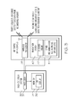
- FIG. 3 is functional block diagram that includes a generalized avionics display system 30 in accordance with an exemplary embodiment.
- Avionics display system 30 includes at least one processor 32 and at least one monitor 34, which is operatively coupled to processor 32.
- processor 32 drives monitor 34 to produce a graphical display 36 that visually provides a pilot and crew with navigational informational pertaining to the host aircraft and to neighboring aircraft within a predetermined vicinity of the host aircraft.
- Graphical display 36 may include visual representations of one or more of flight characteristics pertaining to a neighboring aircraft, as described more fully below.
- Processor 32 may generate display 36 in a two dimensional format (e.g., as a moving map display), in a three dimensional format (e.g., as a perspective display), or in a hybrid format (e.g., in a picture-in-picture or split screen arrangement). More specifically, display 36 maybe a vertical profile ITP display
- Processor 32 may comprise, or be associated with, any suitable number of individual microprocessors, flight control computers, navigational equipment, memories, power supplies, storage devices, interface cards, and other standard components known in the art.
- the processor 32 may include or cooperate with any number of software programs (e.g., avionics display programs) or instructions designed to carry out the various methods, process tasks, calculations, and control/display functions described below.
- Image-generating devices suitable for use as monitor 34 include various analog (e.g., cathode ray tube) and digital (e.g., liquid crystal, active matrix, plasma, etc.) display devices.
- Monitor 34 may be disposed at various locations throughout the cockpit, but preferably reside at a central location within the pilot's primary field-of-view. Alternately, monitor 34 may be mounted at a location for convenient observation by the aircraft crew.
- Processor 32 includes one or more inputs operatively coupled to one or more air traffic data sources.
- the air traffic data sources continually provide processor 32 with navigational data pertaining to neighboring aircraft.
- the air traffic data sources include a wireless transceiver 38 and a navigation system 40, which are operatively coupled to first and second inputs of processor 32, respectively.
- Navigation system 40 includes an onboard radar 42 and various other onboard instrumentation 44, such as a radio altimeter, a barometric altimeter, a global positioning system (GPS) unit, and the like.
- GPS global positioning system
- wireless transceiver 38 is considered an air traffic data source in that transceiver 38 receives navigational data from external sources and relays this data to processor 32.
- wireless transceiver 38 may receive Traffic Collision Avoidance System (TCAS) data and Automatic Dependent Surveillance-Broadcast (ADS-B) data from neighboring aircraft.
- TCAS data, ADS-B data, and other such external source data are preferably formatted to include air traffic state vector information, which may be utilized to determine a neighboring aircraft's current position and velocity.
- processor 32 is configured to determine if degraded traffic data meets predetermined minimum standards of navigational certainty and permit such traffic to be displayed on the vertical profile ITP display that is not displayed under current ITP standards, thus increasing a pilot's situational awareness.
- FIG. 4 illustrates a traffic display graphic that may be generated by processor 32 for display on ITP display 36 and visually represents an intruder aircraft having degraded navigational data and position uncertainty.
- the graphic illustrates (1) a traffic symbol 46 visually representing an intruder aircraft on flight level 48; (2) a graphical representation of uncertainty on the ITP scale (i.e.
- a shaded or transparent rectangle 50 having a length visually representative of plus or minus the radius of containment ( ⁇ Rc)) and wherein the height is visually representative of 200 feet; and (3) a textual representation of uncertainty 52 on the ITP scale represented by a maximum value equal to the ITP distance plus Rc and the minimum of which is the ITP distance minus Rc where Rc is mapped to the ITP distance scale and is derived from the containment mapping table discussed below. If two aircraft, A and B, have the same ground track, the ITP distance is the distance between A and B on their ground track.
- the ITP distance is the absolute value of the distance of aircraft A to common point X minus the distance of aircraft B to common point X , if the aircrafts are approaching point X. Otherwise, the ITP distance is the absolute value of the distance of aircraft A to common point X plus the distance of aircraft B to common point X , if the aircrafts are moving away from the common point X.
- the graphic for display on the ITP also includes a textual representation of ground speed 54 and a symbol 56 that provides a visual indication of whether the ownship and the intruder are separating or closing in the manner in which these parameters have been previously displayed in connection with ITP traffic displays.
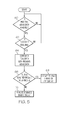
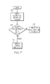
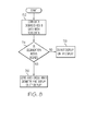
- FIGS. 5 , 6 , 7 and 8 are flowcharts corresponding to three scenarios for generating degraded traffic symbology in processor 32 for display by monitor 34 on ITP display 36.
- the first scenario corresponds to the presence of a traffic intruder that is not transmitting ADS-B data or whose ADS-B data has dropped off. This is accomplished by correlating the intruder's TCAS data received using secondary surveillance radar and previously received and stored ADS-B data. In this manner, the position, track, and velocity of the intruder can be extrapolated. The traffic intruder's navigational accuracy for the new values can thus be determined.
- the second scenario occurs when the intruder is not equipped with ADS-B OUT. In this case, navigational accuracy is determined using TCAS data.
- the third scenario involves aircraft equipped with older installations of ADS-B OUT (e.g. DO-260, DO-260A) having navigational accuracy less than that required to qualify for display on ITP vertical display 36.
- the traffic is considered degraded traffic. That is, if the navigational accuracy category for position (NACp) is less than five, or the navigation integrity category (NIC) is less than five, or the navigation accuracy category for velocity (NACv) is less than one, the intruder is considered degraded traffic and is not displayed on the ITP display.
- NACp navigational accuracy category for position
- NIC navigation integrity category
- NACv navigation accuracy category for velocity
- the representation of degraded traffic intruders is considered useful if they are on a similar track with respect to the ownship, their longitudinal separation is less than the default standard longitudinal separation limit, and their uncertainty is within predefined bounds. Information relating to the maximum and minimum uncertainty in ITP distance may be shown using vertical lines dropping onto the ITP distance scale.
- FIGS 5 and 6 are flowcharts describing a method that may be carried out by the system shown and described in connection with FIG. 3 that for displaying symbology on an ITP display representative of an intruder aircraft when the intruder's ADS-B data is not being transmitted or, for some reason, has dropped off.
- the process commences by determining if there is a history of ADS-B data previously received and stored (STEP 60). If such is the case, and the intruder aircraft is transmitting TCAS data (STEP 62), the TCAS data is correlated with the previously stored ADS-B data (STEP 64). That is, processor 32 utilizes the relationship between TCAS data and previously received ADS-B data to generate and store a table or other multi-dimensional representation of the database of information.
- Processor 32 compares the currently received TCAS data with previously stored ADS-B data to more accurately determine the navigational parameters, including averaging the TCAS data and previously received ADS-B data and associating the TCAS data with the previously received and stored ADS-B data.
- a technique of this type is described in more detail in US2008/0120032 Al published May 22, 2008 and entitled “Methods and Systems of Determining Bearing when ADS-B Data is Unavailable.”
- the ITP parameters such as ITP distance, relative track, and altitude for similar track traffic are determined (STEP 72) in processor 32 from ADS-B reports, TCAS data, or both.
- the ITP distance is described above.
- Similar track is defined as an instantaneous track that is identical, parallel, or one which converges or diverges at less than forty-five degrees or more than 315 degrees.
- An aircraft is considered a blocking aircraft only if the relative track of the ownship and traffic intruder meet this "similar track" criteria.
- the ITP distance of the traffic calculated above (STEP 72) can vary within the radius of containment. If the degradation is within bounds, the uncertainty geometry described above in connection with FIG. 4 will be generated and displayed on ITP display 36 (STEP 76). As previously stated, the information regarding maximum and minimum uncertainty is shown with vertical lines 51 dropping onto the ITP distance scale 53 in FIG. 4 . If the degradation is not within bounds, the data will not be displayed (STEP 78).
- the navigational accuracy and integrity of the TCAS data is computed by the TCAS system as is shown at STEP 80.
- the rest of the process for displaying degraded TCAS data is that shown in STEPS 66, 68, and 70 described in connection with FIG. 5 and STEPS 72, 74, 76, and 78 described in connection with FIG. 6 .
- a third scenario arises when an intruder is equipped with an older ADS-B system (e.g. DO-260, DO-260A) having navigational accuracy less than that required under current standards for qualifying to be displayed on the ITP vertical display.
- degraded ADS-B data is correlated with TCAS data in STEP 82 using techniques described above in connection with STEP 64 in FIG. 5 .
- the rest of the process for displaying degraded ADS-B data is the same as STEPS 66, 68, and 70 in FIG. 5 and thus, the STEPS 72, 74, 76, and 78 shown and described in connection with FIG 6 .
Landscapes
- Engineering & Computer Science (AREA)
- Aviation & Aerospace Engineering (AREA)
- Physics & Mathematics (AREA)
- General Physics & Mathematics (AREA)
- Computer Networks & Wireless Communication (AREA)
- Radar, Positioning & Navigation (AREA)
- Remote Sensing (AREA)
- Traffic Control Systems (AREA)
- Radar Systems Or Details Thereof (AREA)
Applications Claiming Priority (1)
| Application Number | Priority Date | Filing Date | Title |
|---|---|---|---|
| US13/354,777 US8478513B1 (en) | 2012-01-20 | 2012-01-20 | System and method for displaying degraded traffic data on an in-trail procedure (ITP) display |
Publications (2)
| Publication Number | Publication Date |
|---|---|
| EP2618321A2 true EP2618321A2 (de) | 2013-07-24 |
| EP2618321A3 EP2618321A3 (de) | 2014-01-01 |
Family
ID=47678572
Family Applications (1)
| Application Number | Title | Priority Date | Filing Date |
|---|---|---|---|
| EP13150717.0A Withdrawn EP2618321A3 (de) | 2012-01-20 | 2013-01-09 | System und Verfahren zum Anzeigen beeinträchtigter Verkehrsdaten auf einer ITP-Anzeige |
Country Status (2)
| Country | Link |
|---|---|
| US (1) | US8478513B1 (de) |
| EP (1) | EP2618321A3 (de) |
Families Citing this family (4)
| Publication number | Priority date | Publication date | Assignee | Title |
|---|---|---|---|---|
| US9330573B2 (en) | 2009-06-25 | 2016-05-03 | Honeywell International Inc. | Automated decision aid tool for prompting a pilot to request a flight level change |
| US9666080B2 (en) | 2014-07-09 | 2017-05-30 | Honeywell International Inc. | Systems and methods for displaying degraded intruder traffic data on an aircraft display |
| US20160049080A1 (en) * | 2014-08-13 | 2016-02-18 | Honeywell International Inc. | System and method for reducing in-trail procedure (itp) rejection ratio |
| US9530323B1 (en) * | 2015-07-15 | 2016-12-27 | Honeywell International Inc. | Aircraft systems and methods to monitor proximate traffic |
Citations (1)
| Publication number | Priority date | Publication date | Assignee | Title |
|---|---|---|---|---|
| US20080120032A1 (en) | 2004-10-01 | 2008-05-22 | Honeywell International Inc. | Methods and systems of determining bearing when ads-b data is unavailable |
Family Cites Families (77)
| Publication number | Priority date | Publication date | Assignee | Title |
|---|---|---|---|---|
| US3875379A (en) | 1971-05-03 | 1975-04-01 | Carl W Vietor | Terminal airways traffic control system |
| US5077673A (en) | 1990-01-09 | 1991-12-31 | Ryan International Corp. | Aircraft traffic alert and collision avoidance device |
| US6314366B1 (en) | 1993-05-14 | 2001-11-06 | Tom S. Farmakis | Satellite based collision avoidance system |
| US5574647A (en) | 1993-10-04 | 1996-11-12 | Honeywell Inc. | Apparatus and method for computing wind-sensitive optimum altitude steps in a flight management system |
| US6002347A (en) | 1996-04-23 | 1999-12-14 | Alliedsignal Inc. | Integrated hazard avoidance system |
| FR2754364B1 (fr) | 1996-10-03 | 1998-11-27 | Aerospatiale | Procede et dispositif de guidage vertical d'un aeronef |
| FR2761176B1 (fr) | 1997-03-18 | 1999-05-14 | Aerospatiale | Procede et dispositif pour determiner un trajet de vol optimal d'un aeronef |
| JP3406478B2 (ja) | 1997-06-06 | 2003-05-12 | 沖電気工業株式会社 | ターミナル管制用管制卓の航空機位置表示装置 |
| DE69918154T2 (de) | 1998-10-16 | 2005-06-09 | Universal Avionics Systems Corp., Tucson | Warnungsverfahren und -system für flugpläne |
| US6683541B2 (en) | 1999-01-21 | 2004-01-27 | Honeywell International Inc. | Vertical speed indicator and traffic alert collision avoidance system |
| US7411519B1 (en) | 1999-05-14 | 2008-08-12 | Honeywell International Inc. | System and method for predicting and displaying wake vortex turbulence |
| US6433729B1 (en) * | 1999-09-27 | 2002-08-13 | Honeywell International Inc. | System and method for displaying vertical profile of intruding traffic in two dimensions |
| US6469660B1 (en) * | 2000-04-13 | 2002-10-22 | United Parcel Service Inc | Method and system for displaying target icons correlated to target data integrity |
| US7471995B1 (en) | 2000-05-26 | 2008-12-30 | Aerotech Research (Usa), Inc. | Transmission, receipt, combination, sorting, and presentation of vehicle specific environmental conditions and hazards information |
| WO2002039058A2 (en) | 2000-11-08 | 2002-05-16 | Toyota Motor Sales, U.S.A., Inc. | Methods and apparatus for airspace navigation |
| WO2003005060A1 (en) | 2001-07-03 | 2003-01-16 | Honeywell International Inc. | Vertical profile display with arbitrary plane |
| US6683562B2 (en) * | 2001-07-20 | 2004-01-27 | Aviation Communications & Surveillance Systems, Llc | Integrated surveillance display |
| US6711479B1 (en) * | 2001-08-30 | 2004-03-23 | Honeywell International, Inc. | Avionics system for determining terminal flightpath |
| WO2003079136A2 (en) | 2001-10-10 | 2003-09-25 | Mcloughlin Pacific Corporation | Method and apparatus for tracking aircraft and securing against unauthorized access |
| US6799114B2 (en) | 2001-11-20 | 2004-09-28 | Garmin At, Inc. | Systems and methods for correlation in an air traffic control system of interrogation-based target positional data and GPS-based intruder positional data |
| US6828921B2 (en) | 2001-12-05 | 2004-12-07 | The Boeing Company | Data link clearance monitoring and pilot alert sub-system (compass) |
| US6720891B2 (en) | 2001-12-26 | 2004-04-13 | The Boeing Company | Vertical situation display terrain/waypoint swath, range to target speed, and blended airplane reference |
| US6690298B1 (en) | 2002-01-23 | 2004-02-10 | Rockwell Collins, Inc. | Enhanced vertical terrain profile display |
| US6696980B1 (en) | 2002-02-28 | 2004-02-24 | Garmin International, Inc. | Cockpit instrument panel systems and methods of presenting cockpit instrument data |
| US6946976B1 (en) | 2002-02-28 | 2005-09-20 | Garmin International, Inc. | Cockpit display systems and methods of presenting data on cockpit displays |
| US6963291B2 (en) | 2002-05-17 | 2005-11-08 | The Board Of Trustees Of The Leland Stanford Junior University | Dynamic wake prediction and visualization with uncertainty analysis |
| FR2844893B1 (fr) | 2002-09-20 | 2004-10-22 | Thales Sa | Interface homme-machine de commande du pilote automatique pour aerodyne pilote pourvu d'un terminal de reseau de transmission atn. |
| FR2847553B1 (fr) | 2002-11-27 | 2004-12-31 | Eurocopter France | Dispositif d'aide a l'interception par un aeronef d'un segment d'une trajectoire situee dans un plan horizontal et systeme d'aide a l'interception et au suivi d'un tel segment |
| US7386373B1 (en) | 2003-01-07 | 2008-06-10 | Garmin International, Inc. | System, method and apparatus for searching geographic area using prioritized spatial order |
| US6876906B1 (en) | 2003-06-06 | 2005-04-05 | Rockwell Collins | Graphical symbology for depicting traffic position, navigation uncertainty, and data quality on aircraft displays |
| US7366591B2 (en) | 2004-06-21 | 2008-04-29 | Honeywell International, Inc. | System and method for vertical flight planning |
| US7783393B2 (en) | 2004-06-30 | 2010-08-24 | The Boeing Company | Enhanced vertical situation display |
| US7148816B1 (en) * | 2004-08-30 | 2006-12-12 | Rockwell Collins, Inc. | Aircraft traffic source selection and display system and method |
| US7403843B2 (en) | 2004-12-13 | 2008-07-22 | Honeywell International Inc. | Systems and methods for automated deselection of flight plan information from a display |
| US20060290562A1 (en) | 2005-05-05 | 2006-12-28 | Ehresoft Technologies | Maritime contact management and collison avoidance systems and methods |
| US7746343B1 (en) | 2005-06-27 | 2010-06-29 | Google Inc. | Streaming and interactive visualization of filled polygon data in a geographic information system |
| US7375678B2 (en) | 2005-06-29 | 2008-05-20 | Honeywell International, Inc. | Displaying obstacles in perspective view |
| US7477985B2 (en) | 2005-08-10 | 2009-01-13 | Honeywell International Inc. | Method and apparatus for displaying TCAS information with enhanced vertical situational awareness |
| US7650232B1 (en) | 2005-09-22 | 2010-01-19 | The United States Of America As Represented By The Administrator Of The National Aeronautics And Space Administration (Nasa) | Trajectory specification for high capacity air traffic control |
| FR2898675B1 (fr) | 2006-03-14 | 2008-05-30 | Thales Sa | Procede d'amelioration de la securite aeronautique relative aux communications air/sol et a l'environnement des aeronefs |
| US7747382B2 (en) | 2006-07-10 | 2010-06-29 | The Boeing Company | Methods and systems for real-time enhanced situational awareness |
| FR2905505B1 (fr) | 2006-08-30 | 2014-08-15 | Thales Sa | Methode de guidage pour deviation temporaire d'un vehicule suivant initialement une trajectoire predefinie. |
| FR2910124B1 (fr) | 2006-12-15 | 2009-03-06 | Thales Sa | Procede de creation et de mise a jour d'un plan de vol atc en temps reel pour la prise en compte de consignes de vol et dispositif de mise en oeuvre |
| US7979199B2 (en) | 2007-01-10 | 2011-07-12 | Honeywell International Inc. | Method and system to automatically generate a clearance request to deviate from a flight plan |
| US7570178B1 (en) * | 2007-03-15 | 2009-08-04 | Rockwell Collins, Inc. | Traffic display |
| US7961135B2 (en) | 2007-05-02 | 2011-06-14 | Aviation Communication & Surveillance Systems Llc | Systems and methods for air traffic surveillance |
| US7877197B2 (en) | 2007-05-15 | 2011-01-25 | The Boeing Company | Systems and methods for real-time conflict-checked, operationally preferred flight trajectory revision recommendations |
| US7830276B2 (en) | 2007-06-18 | 2010-11-09 | Honeywell International Inc. | System and method for displaying required navigational performance corridor on aircraft map display |
| US7930097B2 (en) | 2007-07-16 | 2011-04-19 | The Boeing Company | Method and apparatus for displaying terrain elevation information |
| US8380424B2 (en) | 2007-09-28 | 2013-02-19 | The Boeing Company | Vehicle-based automatic traffic conflict and collision avoidance |
| US9257047B2 (en) | 2007-12-12 | 2016-02-09 | The Boeing Company | Computation of new aircraft trajectory using time factor |
| US8339284B2 (en) | 2008-03-11 | 2012-12-25 | Honeywell International Inc. | Method and apparatus for displaying flight path information in rotocraft |
| US7903000B2 (en) | 2008-04-29 | 2011-03-08 | The Boeing Company | Representing a holding pattern on a vertical situation display |
| US20100023187A1 (en) | 2008-07-28 | 2010-01-28 | Honeywell International Inc., | System and method for displaying constraint information on a graphical aircraft instrument tape element |
| US9842506B2 (en) | 2008-08-04 | 2017-12-12 | Aviation Communication & Surveillance Systems Llc | Systems and methods for conflict detection using dynamic thresholds |
| US10535275B2 (en) | 2008-08-04 | 2020-01-14 | Aviation Communication & Surveillance Systems Llc | Systems and methods for conflict detection using position uncertainty |
| US8626361B2 (en) | 2008-11-25 | 2014-01-07 | Honeywell International Inc. | System and methods for unmanned aerial vehicle navigation |
| US20100152932A1 (en) | 2008-12-17 | 2010-06-17 | Honeywell International Inc. | System and method for rendering aircraft traffic on a vertical situation display |
| US7965223B1 (en) | 2009-02-03 | 2011-06-21 | Rockwell Collins, Inc. | Forward-looking radar system, module, and method for generating and/or presenting airport surface traffic information |
| US8380367B2 (en) | 2009-03-26 | 2013-02-19 | The University Of North Dakota | Adaptive surveillance and guidance system for vehicle collision avoidance and interception |
| FR2945360B1 (fr) | 2009-05-07 | 2011-07-15 | Airbus France | Procede et dispositif pour faciliter la realisation d'une maneuvre de changement d'altitude avec espacements reduits d'un avion |
| US9330573B2 (en) | 2009-06-25 | 2016-05-03 | Honeywell International Inc. | Automated decision aid tool for prompting a pilot to request a flight level change |
| US8203465B2 (en) | 2009-07-13 | 2012-06-19 | The Boeing Company | Filtering aircraft traffic for display to a pilot |
| US8108133B2 (en) | 2009-09-14 | 2012-01-31 | Honeywell International Inc. | Vehicle position keeping system |
| US20110066362A1 (en) | 2009-09-17 | 2011-03-17 | Honeywell International Inc. | Method and system displaying aircraft in-trail traffic |
| US8892348B2 (en) | 2009-11-18 | 2014-11-18 | The Mitre Corporation | Method and system for aircraft conflict detection and resolution |
| US8514102B2 (en) | 2010-01-14 | 2013-08-20 | Honeywell International Inc. | Aircraft navigation accuracy display system |
| US8665133B2 (en) | 2010-02-04 | 2014-03-04 | Honeywell International Inc. | Methods and systems for presenting weather hazard information on an in-trail procedures display |
| US8271152B2 (en) | 2010-03-10 | 2012-09-18 | Honeywell International Inc. | System and method for rendering an onboard aircraft display for use with in-trail procedures |
| US10429844B2 (en) | 2010-04-29 | 2019-10-01 | Aviation Communication & Surveillance Systems Llc | Systems and methods for providing a vertical profile for an in-trail procedure |
| US9135829B2 (en) | 2010-04-30 | 2015-09-15 | The Boeing Company | Distance separation criteria indicator |
| US8417397B2 (en) | 2010-05-05 | 2013-04-09 | Honeywell International Inc. | Vertical profile display with variable display boundaries |
| US8660713B2 (en) | 2010-05-17 | 2014-02-25 | Honeywell International Inc. | Methods and systems for an improved in-trail procedures display |
| US9355565B2 (en) | 2010-06-23 | 2016-05-31 | Honeywell International Inc. | Crossing traffic depiction in an ITP display |
| FR2965087B1 (fr) * | 2010-09-21 | 2013-05-17 | Dassault Aviat | Dispositif d'assistance a l'equipage d'un aeronef lors de changements de niveau de vol de celui-ci |
| US20120203448A1 (en) * | 2011-02-07 | 2012-08-09 | Honeywell International Inc. | Systems and methods for providing itp clearance information |
| US8626428B2 (en) * | 2011-06-28 | 2014-01-07 | Honeywell International Inc. | Selectable display of aircraft traffic on tracks |
-
2012
- 2012-01-20 US US13/354,777 patent/US8478513B1/en not_active Expired - Fee Related
-
2013
- 2013-01-09 EP EP13150717.0A patent/EP2618321A3/de not_active Withdrawn
Patent Citations (1)
| Publication number | Priority date | Publication date | Assignee | Title |
|---|---|---|---|---|
| US20080120032A1 (en) | 2004-10-01 | 2008-05-22 | Honeywell International Inc. | Methods and systems of determining bearing when ads-b data is unavailable |
Also Published As
| Publication number | Publication date |
|---|---|
| EP2618321A3 (de) | 2014-01-01 |
| US20130191015A1 (en) | 2013-07-25 |
| US8478513B1 (en) | 2013-07-02 |
Similar Documents
| Publication | Publication Date | Title |
|---|---|---|
| EP2884478B1 (de) | System und Verfahren zur textuellen und grafischen Darstellung von Flugverkehrskontroll-Sprachinformationen | |
| CN105280025B (zh) | 用于提供供机场离场和到达程序使用的飞行器显示的飞行器显示系统和方法 | |
| EP3056864B1 (de) | Cockpitanzeigesysteme und verfahren zur erzeugung von navigationsanzeigen mit landungsumleitungssymbologie | |
| US8849477B2 (en) | Avionics display system and method for generating three dimensional display including error-compensated airspace | |
| EP3048424B1 (de) | Verfahren und systeme für route-basierte anzeige meteorologischer informationsvorhersage | |
| US9499279B2 (en) | System and method for displaying runway approach information | |
| US10543931B2 (en) | Method and system for contextually concatenating display, aural, and voice alerts | |
| US9354078B2 (en) | Methods and systems for indicating whether an aircraft is within distance and altitude criteria for an IFR procedure turn | |
| EP3166092A1 (de) | Flugzeugsysteme und verfahren mit verbesserter cpdlc-nachrichtenverwaltung | |
| EP2779140B1 (de) | System und Verfahren zur Alarmierung des Flugzeugpersonals vor Schwellenhöhen | |
| US9377325B2 (en) | System and method for graphically displaying airspace speed data | |
| US10157617B2 (en) | System and method for rendering an aircraft cockpit display for use with ATC conditional clearance instructions | |
| US9159241B1 (en) | Methods, systems, and apparatus for synthetic instrument landing system (SILS) | |
| US10407179B2 (en) | Aircraft systems and methods for displaying wind shear | |
| EP2980772B1 (de) | System und verfahren zur automatischen identifizierung von angezeigtem, von der flugsicherung erwähntem verkehr | |
| EP3023741B1 (de) | System und verfahren zur exozentrischen anzeige von integrierter navigation | |
| EP2790167A2 (de) | System und Verfahren zum Anzeigen der graphisch und textuell repräsentativen Symbologie auf einer ITP-Anzeige eines vertikalen Verkehrsszenarios und von Flugsicherungsverhandlung | |
| EP2940674A1 (de) | System und verfahren zur anzeige von kontextempfindlichen notizen | |
| US8478513B1 (en) | System and method for displaying degraded traffic data on an in-trail procedure (ITP) display | |
| EP3470791B1 (de) | Verfahren und system zur bereitstellung von kontextueller autokorrelation von vertikalen situativen anzeigeobjekten zu objekten, die auf einer lateralen kartenanzeige auf basis eines prioritätsschemas angezeigt werden | |
| EP2808857A1 (de) | Verfahren zur Erhöhung des situativen Bewusstseins durch Anzeige von Höhenfilter-Grenzlinien auf einer vertikalen Situationsanzeige |
Legal Events
| Date | Code | Title | Description |
|---|---|---|---|
| PUAI | Public reference made under article 153(3) epc to a published international application that has entered the european phase |
Free format text: ORIGINAL CODE: 0009012 |
|
| 17P | Request for examination filed |
Effective date: 20130109 |
|
| AK | Designated contracting states |
Kind code of ref document: A2 Designated state(s): AL AT BE BG CH CY CZ DE DK EE ES FI FR GB GR HR HU IE IS IT LI LT LU LV MC MK MT NL NO PL PT RO RS SE SI SK SM TR |
|
| AX | Request for extension of the european patent |
Extension state: BA ME |
|
| PUAL | Search report despatched |
Free format text: ORIGINAL CODE: 0009013 |
|
| AK | Designated contracting states |
Kind code of ref document: A3 Designated state(s): AL AT BE BG CH CY CZ DE DK EE ES FI FR GB GR HR HU IE IS IT LI LT LU LV MC MK MT NL NO PL PT RO RS SE SI SK SM TR |
|
| AX | Request for extension of the european patent |
Extension state: BA ME |
|
| RIC1 | Information provided on ipc code assigned before grant |
Ipc: G08G 5/00 20060101AFI20131127BHEP |
|
| 17Q | First examination report despatched |
Effective date: 20131213 |
|
| RAP1 | Party data changed (applicant data changed or rights of an application transferred) |
Owner name: HONEYWELL INTERNATIONAL INC. |
|
| STAA | Information on the status of an ep patent application or granted ep patent |
Free format text: STATUS: THE APPLICATION IS DEEMED TO BE WITHDRAWN |
|
| 18D | Application deemed to be withdrawn |
Effective date: 20160802 |