EP2374019B1 - Melden von positionsbestimmungsdaten - Google Patents
Melden von positionsbestimmungsdaten Download PDFInfo
- Publication number
- EP2374019B1 EP2374019B1 EP09779433.3A EP09779433A EP2374019B1 EP 2374019 B1 EP2374019 B1 EP 2374019B1 EP 09779433 A EP09779433 A EP 09779433A EP 2374019 B1 EP2374019 B1 EP 2374019B1
- Authority
- EP
- European Patent Office
- Prior art keywords
- polygon
- ellipsoid
- altitude
- calculating
- uncertainty
- Prior art date
- Legal status (The legal status is an assumption and is not a legal conclusion. Google has not performed a legal analysis and makes no representation as to the accuracy of the status listed.)
- Not-in-force
Links
Images



Classifications
-
- G—PHYSICS
- G01—MEASURING; TESTING
- G01S—RADIO DIRECTION-FINDING; RADIO NAVIGATION; DETERMINING DISTANCE OR VELOCITY BY USE OF RADIO WAVES; LOCATING OR PRESENCE-DETECTING BY USE OF THE REFLECTION OR RERADIATION OF RADIO WAVES; ANALOGOUS ARRANGEMENTS USING OTHER WAVES
- G01S5/00—Position-fixing by co-ordinating two or more direction or position line determinations; Position-fixing by co-ordinating two or more distance determinations
- G01S5/02—Position-fixing by co-ordinating two or more direction or position line determinations; Position-fixing by co-ordinating two or more distance determinations using radio waves
- G01S5/0252—Radio frequency fingerprinting
-
- G—PHYSICS
- G01—MEASURING; TESTING
- G01S—RADIO DIRECTION-FINDING; RADIO NAVIGATION; DETERMINING DISTANCE OR VELOCITY BY USE OF RADIO WAVES; LOCATING OR PRESENCE-DETECTING BY USE OF THE REFLECTION OR RERADIATION OF RADIO WAVES; ANALOGOUS ARRANGEMENTS USING OTHER WAVES
- G01S5/00—Position-fixing by co-ordinating two or more direction or position line determinations; Position-fixing by co-ordinating two or more distance determinations
- G01S5/0009—Transmission of position information to remote stations
-
- G—PHYSICS
- G06—COMPUTING OR CALCULATING; COUNTING
- G06T—IMAGE DATA PROCESSING OR GENERATION, IN GENERAL
- G06T17/00—Three-dimensional [3D] modelling for computer graphics
- G06T17/05—Geographic models
Definitions
- the present invention relates in general to positioning or location based services in different network architectures.
- AECID Adaptive Enhanced Cell ID
- An object of the present invention is to provide methods and devices that allows for reporting of information based on a polygon enhanced with altitude information utilizing standard compliant means.
- the above object is achieved by methods and arrangements according to the enclosed independent patent claims. Different preferred embodiments are achieved by methods and arrangements according to the enclosed dependent patent claims.
- a method for reporting of positioning data in a communication network comprises obtaining of positioning data comprising a definition of a polygon in a lateral plane with information of altitude associated to each polygon corner.
- the method further comprises approximating the polygon with an ellipsoid point having altitude and uncertainty ellipsoid and reporting of the ellipsoid point having altitude and uncertainty ellipsoid over an interface of the communication network as a representation of the positioning data.
- a node in a communication network comprises a report converter arranged for obtaining positioning data comprising a definition of a polygon in a lateral plane with information of altitude associated to each polygon corner.
- the report converter is further arranged for approximating the polygon with an ellipsoid point having altitude and uncertainty ellipsoid.
- the node further comprises a report unit connected to the report converter and to an interface of the communication network.
- the report unit is arranged for reporting the ellipsoid point having altitude and uncertainty ellipsoid over the interface as a representation of the positioning data.
- One advantage with the present invention is that only the reporting node has to be updated with new functionality. The receiving side is not affected.
- Another advantage with the present invention is that altitude information achieved e.g. by AECID can be utilized for positioning of user equipment that itself do not have any altitude measuring means.
- AECID is a fingerprinting positioning technology that refines the basic fingerprinting methods in a variety of ways.
- a first recent published international patent application WO 2007/043915 discloses the main ideas of the invention.
- the AECID gives rise to position determination assisting data constituted by an area definition in the shape of a polygon.
- FIG.1 The polygon format exploited by the basic two-dimensional AECID method is best described by Fig.1 .
- An area 12 is defined by a number of sides 14 of a polygon 16.
- the polygon is entirely defined by defining positions of a number of polygon corners 10A-E together with information how the polygon corners are connected.
- the selected number of polygon corners 10A-E must be between 3 and 15.
- the polygon 16 is not allowed to intersect itself. A special case of the latter conditions is that all polygon corners 10A-E need to be different.
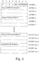
- Fig. 2 illustrates the 3GPP Polygon message IE (Information Element).
- This IE is present in the LOCATION REPORT message that is returned to the core network over the RANAP interface e.g. after a successful cell identity positioning.
- a polygon obtained by a standard two-dimensional AECID procedure can thus easily be reported using this standard polygon message.
- the polygon can also be complemented by altitude information associated to each polygon corner.
- altitude information is important e.g. in metropolitan areas with tall buildings, where the cell planning may be 3 dimensional.
- the addition of altitude to the corners of the polygon as achieved by e.g. AECID is straightforward. It is obtained by the following two steps. In the first step, for each corner, a predetermined number of reference points of the underlying cluster are determined. These reference points are the reference points closest to the corner. In the second step, for each polygon corner, the average of the altitudes of the closest reference points are used as an estimate of the altitude of the polygon corner.
- altitude parameter in the area description from AECID also gives terminals without altitude measurement capability, e.g. without A-GPS or without barometric altimeters, a possibility to be positioned also in altitude, by using the AECID position determination assisting data.
- altitude information gives rise to some problems.
- the positioning functionality for cellular systems known in prior art does not allow standard compliant reporting of altitude information, when the horizontal data is provided as a polygon. The consequence is that altitude information cannot be provided to the end user in case of fallback emergency positioning.
- terminals without altitude measurement capability e.g. without A-GPS or without barometric altimeters, cannot be provided with altitude information.
- One way to obtain a 2-dimensional ellipse from a polygon would be to first compute the covariance matrix in 2 dimensions, using the coordinates of the polygon corners. An eigenvalue analysis then gives the minor axis, the major axis and the angle with respect to north of the major axis.
- the main drawback is that scaling properties are not completely preserved since the confidence value of the polygon is not used to constrain the size of the computed polygon.
- the present invention is based on another conversion.
- a geographical shape conversion from polygons with altitude information to ellipsoid point with altitude and uncertainty ellipsoid is used.
- An ellipsoid point with altitude and uncertainty ellipsoid is compatible with 3GPP formats.
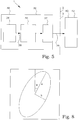
- Such a geometric shape is illustrated in Fig. 3 .
- An ellipsoid point 24 is encircled by an uncertainty ellipsoid 20.
- a projection point 26 of the ellipsoid point 24 onto a plane with zero height is illustrated and also a projection ellipse 22 corresponding to the uncertainty ellipsoid 20.
- FIG. 4 illustrates a 3GPP Ellipsoid Point with Altitude and Uncertainty Ellipsoid message IE (Information Element).
- This IE is present in the LOCATION REPORT message that is returned to the core network over the RANAP interface e.g. after a successful A-GPS positioning.
- a first node 30, in a wireless communication system 1 communicates with a second node 40.
- the first node is typically an RNC 32 and the second node is typically a MSC 42.
- the communication takes place over a communication interface 2, in this case a 3GPP interface 3.
- the first node comprises positioning unit 34 creating positioning data, typically arranged with an AECID arrangement, giving an output 38 comprising a polygon and altitudes for each polygon corner.
- a report converter 36 is arranged for obtaining the positioning data comprising a definition of a polygon in a lateral plane with information of altitude associated to each polygon corner and approximating the polygon with an ellipsoid point having altitude and uncertainty ellipsoid.
- the output 39 from the report converter 36 thereby comprises a definition of the ellipsoid point having altitude and uncertainty ellipsoid.
- This output 39 is supplied to a report unit 37, connected to the report converter 36 and to the communication interface 2.
- the report unit 37 is arranged for reporting the ellipsoid point having altitude and uncertainty ellipsoid over the interface as a representation of the positioning data.
- the transmission over the 3GPP interface 3 of the area information or positioning data, originally computed as a polygon 38 with associated corner altitudes is thus performed in the shape of an ellipsoid point 39 with altitude and uncertainty ellipsoid.
- the conversion is made in the same node as provides the polygon with altitude.
- the positioning unit 34 may alternatively be provided in another node connected to the node in which the report converter 36 is provided.
- the report converter 36 is then connected to a receiver, which receiver is arranged for receiving the positioning data from the external positioning unit 34.
- the area is assumed to be defined by the ellipsoid point with altitude and uncertainty ellipsoid.
- the node 30 responsible for providing the polygon 38 with altitude and the shape conversion is typically situated in the core network of the wireless communication system or in the RNC, while the receiving node 40 typically is another CN node, e.g. a MSC 42, since this type of information normally flows in that direction. However, also the opposite is possible.
- Fig. 6 illustrates a flow diagram of main steps of an embodiment of a method according to the present invention.
- the method for reporting of positioning data in a communication network starts in step 200.
- step 202 positioning data comprising a definition of a polygon in a lateral plane with information of altitude associated to each polygon corner is obtained.
- the polygon is in step 204 approximated with an ellipsoid point having altitude and uncertainty ellipsoid.
- the ellipsoid point having altitude and uncertainty ellipsoid is reported over an interface of the communication network as a representation of the positioning data.
- the method ends in step 209.
- the shape conversion from polygon with altitude to ellipsoid point with altitude and uncertainty ellipsoid can be performed in different ways. However, in a preferred embodiment, the conversion is made as follows. First the two-dimensional polygon information is shape conversed into an ellipse. This is basically made according to the lines as reproduced in Appendix A.
- the starting point for the construction of the ellipsoid point with altitude and uncertainty ellipsoid is to compute the ellipsoid point with altitude part.
- the ellipsoid point follows from (A3) and (A4) of Appendix A.
- a lateral centre of gravity of the polygon is calculated as lateral parameters of the ellipsoid point.
- z CG is the altitude of the ellipsoid point with altitude, being equal to the altitude center of gravity of the polygon corners.
- z ⁇ denote the altitudes of the polygon corners.
- the 3D covariance matrix corresponding to the polygon with altitude needs to be constructed. It is well known that the 2D principal axes of the covariance matrix correspond to the semi-major and semi-minor axes of the ellipse when a 38% (0.38) confidence C e is applied in the 2D algorithm described in Appendix A. A direction of a longest line segment through the centre of gravity with end points on a boundary of the polygon is searched for as an orientation of a major axis of the ellipsoid point.
- a scaling with a factor of ⁇ is applied to all axes of the covariance matrix in order to achieve the desired 3D confidence C 3D .
- the calculation of the uncertainty ellipsoid is thus based on a 3-dimensional covariance matrix of the polygon with altitude. Due to the Gaussian assumption, this means that the following equation needs to be fulfilled:
- the computed information is encoded, e.g. according to the 3GPP standard. This enables reporting of altitude over 3GPP interfaces.
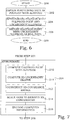
- Fig. 7 summarizes the presently preferred embodiment of the approximating step 204 ( Fig. 6 ).
- step 210 the ellipsoid point with altitude part is computed.
- a lateral centre of gravity of the polygon is calculated as lateral parameters of the ellipsoid point and a mean of the altitudes associated to each polygon corner is calculated as altitude parameters of the ellipsoid point.
- a search is performed, for a direction of a longest line segment through the centre of gravity with end points on a boundary of the polygon. This direction is selected as an orientation of a major axis of the ellipsoid point.
- step 211 a 2D uncertainty ellipse is computed.
- step 212 sizes of the horizontal semi-major and semi-minor axes corresponding to confidence values associated with the confidence of the polygon are calculated in a lateral plane with information of altitude associated to each polygon corner.
- the 3D covariance matrix corresponding to the polygon with altitude is constructed in step 212.
- a standard deviation of the altitude associated to each polygon corner in a lateral plane is calculated with information of altitude associated to each polygon corner.
- a scaling with a factor of ⁇ is in step 214 applied to all axes of the covariance matrix in order to achieve the desired 3D confidence C 3D . This is preferably performed by a table look-up.
- the computed information is encoded, e.g. according to the 3GPP standard.
- the invention relates to the fingerprinting positioning algorithm that is a part external positioning nodes for GSM, under consideration also for LTE and WCDMA.
- This fingerprinting algorithm has the ability to produce altitudes, of each of the corners of the polygons the algorithm computes.
- the invention provides means for transforming the polygon with altitudes to a point with altitude and uncertainty ellipsoid - a format that is available as a 3GPP standard format.
- the present invention makes it possible to provide altitude in addition to position, also to terminals that are not capable of measurement of altitude, e.g. terminals that are not A-GPS capable.
- the reporting problem is general in the sense that the 3GPP formats involved are used over RANAP, RNSAP, in the CN and in secure user plane localization (SUPL) for WCDMA, and probably for the corresponding LTE interfaces, when these are finalized in 3GPP R9.
- the advantages of the invention are significant for cellular systems with a large number of non-A-GPS capable terminals - i.e. the majority of the present cellular networks.
- the addition of altitude information is important e.g. in urban metropolitan areas with tall buildings, where the cell planning is 3 dimensional. There emergency positioning would benefit by an altitude providing positioning fallback method to A-GPS.
- the invention also provides an altimeter to terminals that are not equipped with A-GPS.
- the task in this part is to transform a confidence region described by the polygon format and a confidence value for the polygon, to a confidence region described by the ellipse format, and a (possibly different) confidence value for the ellipse.
- the ellipse does not carry altitude information since the polygon does not.
- the polygon format is illustrated by Fig. 2 .
- the polygon is defined by a list of 3-15 corners, in WGS 84 co-ordinates. No self-intersections are allowed. In the description that follows the corners are assumed to have been transformed to a local earth-tangential Cartesian co-ordinate system, with co-ordinate axes in the north and east directions.
- Step 1 Computation of the area of the polygon.
- the computation is performed by a division of the polygon into non-overlapping triangles. This step is well known in prior art.
- N P denotes the integer argument modulo the integer number of corners, N p .
- Step 2 Computation of the center of gravity of the polygon.
- the center of gravity is denoted ( x CG y CG ) .
- Standard results, based on a division of the polygon into non-overlapping triangles, then show that: x CG 1 6
- a p ⁇ i 1 N p x i y i N p + 1 ⁇ x i N p + 1 y i y i + y i N p + 1 .
- Step 3 Search for the longest line segment, through the center of gravity, with end points on polygon boundary.
- This step determines the orientation of the semi-major axis, in terms of the angle ⁇ .
- the idea is to search over a discretized set of lines that all pass through the center of gravity, in order to find the line with the longest line segment with end points on the boundary of the polygon. This search is performed by:
- x and y denote the x- and y-component of a vector, respectively.
- ⁇ the parameters ⁇ and ⁇ are determined. Obviously, in case ⁇ ⁇ [0,1] then the intersection falls between said corner points and is valid, otherwise it is discarded.
- the calculation of ⁇ and ⁇ are repeated for all line segments of the boundary of the polygon. Since the direction vector is of the line through the center of gravity is normalized, it follows that the length of the line segment between the center of gravity and the boundary is given by the corresponding ⁇ .
- This value of ⁇ determines the orientation of the semi-major axis.
- the lengths of the semi-major and semi-minor axes are determined in a subsequent optimization step.
- Step 4 Translation and rotation of the polygon.
- the polygon corners are transformed so that the center of gravity of the polygon is moved to the origin of the co-ordinate system and so the orientation of the semi-major axis coincides with the x-axis.
- r p ⁇ r p ⁇ r CG
- r p ⁇ cos ⁇ e sin ⁇ e ⁇ sin ⁇ e cos ⁇ e r p ⁇ .
- Step 5 Optimization of semi-major and semi-minor axes against polygon boundary.
- the confidence equals the probability that the terminal is actually located in the region that is determined and reported by the positioning method.
- the polygon regions are large and a reasonable assumption is that the distributions of users is uniform across the polygon.
- the reported ellipsoidal uncertainty are is related to a measurement error.
- the UE is distributed according to a multi-dimensional normal distribution over the uncertainty region.
- the confidence value of the polygon is denoted C p .
- Equation (A14) provides a constraint that can be used in order to eliminate one of a or b from the optimization problem below, thereby reducing this problem to a one dimensional one. Note that A p is available from step 1 (A2).
- the optimization is performed against the y-coordinate of the transformed polygon corner points, i.e. y i ".
- the x-coordinate could be used instead.
- the optimization could be performed in a non-Cartesian co-ordinate system, e.g. a polar co-ordinate system.
- the optimization can be extended to include also other points than corner points in the criterion, e.g. points taken on the boundary of the polygon. Note that all such points can be defined as corner points, by a division of the line segment on which the boundary point is located, into two pieces.
Landscapes
- Physics & Mathematics (AREA)
- Engineering & Computer Science (AREA)
- Remote Sensing (AREA)
- General Physics & Mathematics (AREA)
- Geometry (AREA)
- Software Systems (AREA)
- Radar, Positioning & Navigation (AREA)
- Computer Graphics (AREA)
- Theoretical Computer Science (AREA)
- Position Fixing By Use Of Radio Waves (AREA)
Claims (8)
- Verfahren zum Melden von Positionsbestimmungsdaten in einem Kommunikationsnetzwerk (1), umfassend die folgenden Schritte:Erlangen (202) von Positionsbestimmungsdaten umfassend eine Definition eines Polygons (16) auf einer lateralen Ebene mit Höhenlageninformation in Verbindung mit jeder Polygonecke (10A-E);Annähern (204) des Polygons (16) mit einem Ellipsoidpunkt (24), der laterale Parameter und Höhenlagenparameter hat, und mit einem Ungewissheitsellipsoid (20), der den Ellipsoidpunkt (24) einkreist;der Annäherungsschritt (204) umfassend die folgenden Schritte:Berechnen des Schwerpunkts des Polygons (16) definiert auf der lateralen Ebene als laterale Parameter des Ellipsoidpunkts;Berechnen des Mittelwerts der Höhenlagen in Verbindung mit jeder Polygonecke (10A-E) als Höhenlagenparameter des Ellipsoidpunkts; undBerechnen des Ungewissheitsellipsoids (20), das den Ellipsoidpunkt (24) einkreist; undMelden (206) des Ellipsoidpunkts (24) und Ungewissheitsellipsoids (20) über eine Schnittstelle (2) des Kommunikationsnetzwerks (1) als eine Darstellung der Positionsbestimmungsdaten.
- Verfahren nach Anspruch 1, dadurch gekennzeichnet, dass der Annäherungsschritt (204) ferner die folgenden Schritte umfasst:Suchen nach einer Richtung eines längsten Liniensegments durch den Schwerpunkt mit Endpunkten an einer Grenzlinie des Polygons (16) als eine Ausrichtung einer größten Achse des Ungewissheitsellipsoids.
- Verfahren nach Anspruch 1 oder 2, dadurch gekennzeichnet, dass der Annäherungsschritt (204) ferner die folgenden Schritte umfasst:Berechnen von Größen der horizontalen semi-größten und semi-kleinsten Achse entsprechend Konfidenzwerten in Verbindung mit der Konfidenz des Polygons (16) auf einer lateralen Ebene mit Höhenlageninformationen in Verbindung mit jeder Polygonecke (10A-E); undBerechnen einer Standardabweichung der Höhenlage in Verbindung mit jeder Polygonecke (10A-E) auf einer lateralen Ebene mit Höhenlageninformationen in Verbindung mit jeder Polygonecke (10A-E).
- Verfahren nach Anspruch 3, dadurch gekennzeichnet, dass der Annäherungsschritt (204) ferner die folgenden Schritte umfasst:Berechnen des Ungewissheitsellipsoids beruhend auf einer dreidimensionalen Kovarianzmatrix des Polygons mit Höhenlage.
- Verfahren nach Anspruch 4, dadurch gekennzeichnet, dass der Berechnungsschritt des Ungewissheitsellipsoids ein Entnehmen eines Skalenfaktors aus einer vorbestimmten Suchtabelle umfasst.
- Knoten (30) in einem Kommunikationsnetzwerk (1), umfassend:einen Meldungsumwandler (36), der angeordnet ist, um Positionsbestimmungsdaten umfassend eine Definition eines Polygons (16) auf einer lateralen Ebene mit Höhenlageninformationen in Verbindung mit jeder Polygonecke (10A-E) zu erlangen,wobei der Meldungsumwandler (36) ferner angeordnet ist, um das Polygon (16) an einen Ellipsoidpunkt (24), der laterale Parameter and Höhenlagenparameter hat, und an ein Ungewissheitsellipsoid (20), das den Ellipsoidpunkt (24) einkreist, durch Berechnen des Schwerpunkts des Polygons (16) als laterale Parameter des Ellipsoidpunkts, Berechnen des Mittelwerts der Höhenlagen in Verbindung mit jeder Polygonecke (10A-E) als Höhenlagenparameter des Ellipsoidpunkts und Berechnen des Ungewissheitsellipsoids (20), das den Ellipsoidpunkt (24) einkreist, anzunähern; undeine Meldungseinheit (37), die mit dem Meldungsumwandler (36) und einer Schnittstelle (2) des Kommunikationsnetzwerks (1) verbunden und angeordnet ist, um den Ellipsoidpunkt (24) und das Ungewissheitsellipsoid (20) über die Schnittstelle (2) als eine Darstellung der Positionsbestimmungsdaten zu melden.
- Knoten nach Anspruch 6, gekennzeichnet durch eine Positionierungseinheit (34), die mit dem Meldungsumwandler (36) verbunden ist, wobei die Positionierungseinheit (34) zum Erzeugen der Positionsbestimmungsdaten angeordnet ist.
- Knoten nach Anspruch 6, gekennzeichnet durch einen Empfänger, der mit dem Meldungsumwandler (36) verbunden ist, wobei der Empfänger angeordnet ist, um die Positionierungsdaten von einem externen Positionierungsknoten zu empfangen.
Applications Claiming Priority (2)
| Application Number | Priority Date | Filing Date | Title |
|---|---|---|---|
| US13825208P | 2008-12-17 | 2008-12-17 | |
| PCT/EP2009/055615 WO2010069614A1 (en) | 2008-12-17 | 2009-05-08 | Reporting of positioning data |
Publications (2)
| Publication Number | Publication Date |
|---|---|
| EP2374019A1 EP2374019A1 (de) | 2011-10-12 |
| EP2374019B1 true EP2374019B1 (de) | 2017-07-12 |
Family
ID=41050335
Family Applications (1)
| Application Number | Title | Priority Date | Filing Date |
|---|---|---|---|
| EP09779433.3A Not-in-force EP2374019B1 (de) | 2008-12-17 | 2009-05-08 | Melden von positionsbestimmungsdaten |
Country Status (3)
| Country | Link |
|---|---|
| US (1) | US9097786B2 (de) |
| EP (1) | EP2374019B1 (de) |
| WO (1) | WO2010069614A1 (de) |
Families Citing this family (10)
| Publication number | Priority date | Publication date | Assignee | Title |
|---|---|---|---|---|
| US8755816B2 (en) * | 2009-12-30 | 2014-06-17 | Telefonaktiebolaget L M Ericsson (Publ) | Method and apparatus for position determination in a cellular communications system |
| WO2012011855A1 (en) * | 2010-07-19 | 2012-01-26 | Telefonaktiebolaget L M Ericsson (Publ) | Pre-scaling of a-gps positioning accuracy data |
| CN103180753B (zh) * | 2010-11-05 | 2015-09-23 | 瑞典爱立信有限公司 | 用于定位信息报告的方法和装置 |
| US20140112201A1 (en) * | 2012-10-24 | 2014-04-24 | International Business Machines Corporation | Forming a Convex Polygon of Mobile Sensors |
| WO2014155151A1 (en) * | 2013-03-26 | 2014-10-02 | Nokia Corporation | Utilizing shortened derivatives of identifiers of entities of communication systems for retrieving positioning information |
| WO2015096164A1 (zh) * | 2013-12-27 | 2015-07-02 | 华为技术有限公司 | 一种无线通信方法及装置 |
| CN106096136B (zh) * | 2016-06-13 | 2019-03-26 | 湖南大学 | 一种车辆安全性设计的聚类-多椭球不确定性度量方法 |
| EP3756388A1 (de) | 2018-02-21 | 2020-12-30 | Telefonaktiebolaget Lm Ericsson (Publ) | Signalisierung von skalierten 3d-positionsinformation |
| EP3756026B1 (de) * | 2018-02-21 | 2024-10-02 | Telefonaktiebolaget Lm Ericsson (Publ) | Skalierte tdoa 3d-positionierung |
| CN112683265B (zh) * | 2021-01-20 | 2023-03-24 | 中国人民解放军火箭军工程大学 | 一种基于快速iss集员滤波的mimu/gps组合导航方法 |
Family Cites Families (7)
| Publication number | Priority date | Publication date | Assignee | Title |
|---|---|---|---|---|
| FR2814898B1 (fr) * | 2000-09-29 | 2002-11-29 | Sfr Sa | Procede et dispositif de calcul de la position d'une station mobile, programme informatique et support memoire correspondants |
| US7676232B2 (en) | 2002-05-16 | 2010-03-09 | Telefonaktiebolaget Lm Ericsson (Publ) | Altitude determination and distribution in cellular communication systems |
| CN1798983B (zh) * | 2003-04-25 | 2011-12-07 | 高通股份有限公司 | 获得信号捕获辅助数据的系统和方法 |
| US8315632B2 (en) | 2005-10-07 | 2012-11-20 | Telefonaktiebolaget Lm Ericsson (Publ) | Adaptive enhanced cell identity positioning |
| US8364164B2 (en) * | 2006-08-11 | 2013-01-29 | Csr Technology Inc. | Cell ID based positioning from cell intersections |
| JP5406031B2 (ja) * | 2006-10-30 | 2014-02-05 | テレフオンアクチーボラゲット エル エム エリクソン(パブル) | 拡張された位置決定報告 |
| US8200250B2 (en) * | 2007-04-11 | 2012-06-12 | Telefonaktiebolaget L M Ericsson (Publ) | Transformation of positioning reporting formats |
-
2009
- 2009-05-08 EP EP09779433.3A patent/EP2374019B1/de not_active Not-in-force
- 2009-05-08 WO PCT/EP2009/055615 patent/WO2010069614A1/en not_active Ceased
- 2009-05-08 US US13/140,250 patent/US9097786B2/en active Active
Non-Patent Citations (1)
| Title |
|---|
| TORBJÖRN WIGREN: "Adaptive Enhanced Cell-ID Fingerprinting Localization by Clustering of Precise Position Measurements", IEEE TRANSACTIONS ON VEHICULAR TECHNOLOGY., vol. 56, no. 5, 1 September 2007 (2007-09-01), US, pages 3199 - 3209, XP055272813, ISSN: 0018-9545, DOI: 10.1109/TVT.2007.900400 * |
Also Published As
| Publication number | Publication date |
|---|---|
| US9097786B2 (en) | 2015-08-04 |
| US20110244885A1 (en) | 2011-10-06 |
| WO2010069614A1 (en) | 2010-06-24 |
| EP2374019A1 (de) | 2011-10-12 |
Similar Documents
| Publication | Publication Date | Title |
|---|---|---|
| EP2374019B1 (de) | Melden von positionsbestimmungsdaten | |
| US8755816B2 (en) | Method and apparatus for position determination in a cellular communications system | |
| US8768378B2 (en) | Method and arrangement for improved positioning | |
| EP2620024B1 (de) | Erzeugung und verwendung von reichweitenmodellen | |
| JP5032586B2 (ja) | 改良セル識別およびセル測位のための方法および構成 | |
| EP4034948B1 (de) | Verfahren, vorrichtung und computerprogramm zur lokalisierung von benutzergeräten | |
| CN106455058B (zh) | 一种确定人口分布情况的方法及装置 | |
| EP2419753B1 (de) | Bestimmen einer position eines endgeräts | |
| CN103180753B (zh) | 用于定位信息报告的方法和装置 | |
| US9462424B2 (en) | Indoor positioning method and apparatus | |
| EP1506429B1 (de) | Höhenbestimmung und -verbreitung in zellularen kommunikationssystemen | |
| US20200145790A1 (en) | Positioning correction method and apparatus | |
| EP2404386B1 (de) | Prüfung von endgerätpositionen an einem endgerät | |
| US8200250B2 (en) | Transformation of positioning reporting formats | |
| EP3756026B1 (de) | Skalierte tdoa 3d-positionierung | |
| CN103404177B (zh) | 用于定位的节点和方法 | |
| EP2374021B1 (de) | Verfahren und anordnungen zur fingerabdruck-positionsbestimmung | |
| CN102257840B (zh) | 用于改进定位的方法和装置 | |
| Lin et al. | Mobile location estimation and tracking for GSM systems | |
| CN113676831A (zh) | 一种终端位置定位方法及设备 | |
| EP2596663B1 (de) | Vorskalierung von a-gps-positionierungspräzisionsdaten | |
| CN116915345A (zh) | 一种信号强度估计方法、装置、设备及可读存储介质 | |
| Horn et al. | Nonlinear set-theoretic position estimation of cellular phones | |
| WO2025236672A1 (zh) | 智能定位方法、通信装置、存储介质以及程序产品 |
Legal Events
| Date | Code | Title | Description |
|---|---|---|---|
| PUAI | Public reference made under article 153(3) epc to a published international application that has entered the european phase |
Free format text: ORIGINAL CODE: 0009012 |
|
| 17P | Request for examination filed |
Effective date: 20110704 |
|
| AK | Designated contracting states |
Kind code of ref document: A1 Designated state(s): AT BE BG CH CY CZ DE DK EE ES FI FR GB GR HR HU IE IS IT LI LT LU LV MC MK MT NL NO PL PT RO SE SI SK TR |
|
| DAX | Request for extension of the european patent (deleted) | ||
| 17Q | First examination report despatched |
Effective date: 20141128 |
|
| GRAP | Despatch of communication of intention to grant a patent |
Free format text: ORIGINAL CODE: EPIDOSNIGR1 |
|
| INTG | Intention to grant announced |
Effective date: 20161124 |
|
| RIC1 | Information provided on ipc code assigned before grant |
Ipc: G01S 5/00 20060101ALI20161111BHEP Ipc: G01S 5/02 20060101AFI20161111BHEP Ipc: G06T 17/05 20110101ALI20161111BHEP Ipc: H04W 64/00 20090101ALI20161111BHEP |
|
| GRAJ | Information related to disapproval of communication of intention to grant by the applicant or resumption of examination proceedings by the epo deleted |
Free format text: ORIGINAL CODE: EPIDOSDIGR1 |
|
| GRAP | Despatch of communication of intention to grant a patent |
Free format text: ORIGINAL CODE: EPIDOSNIGR1 |
|
| INTC | Intention to grant announced (deleted) | ||
| INTG | Intention to grant announced |
Effective date: 20170222 |
|
| GRAS | Grant fee paid |
Free format text: ORIGINAL CODE: EPIDOSNIGR3 |
|
| GRAA | (expected) grant |
Free format text: ORIGINAL CODE: 0009210 |
|
| AK | Designated contracting states |
Kind code of ref document: B1 Designated state(s): AT BE BG CH CY CZ DE DK EE ES FI FR GB GR HR HU IE IS IT LI LT LU LV MC MK MT NL NO PL PT RO SE SI SK TR |
|
| REG | Reference to a national code |
Ref country code: GB Ref legal event code: FG4D |
|
| REG | Reference to a national code |
Ref country code: CH Ref legal event code: EP |
|
| REG | Reference to a national code |
Ref country code: AT Ref legal event code: REF Ref document number: 908854 Country of ref document: AT Kind code of ref document: T Effective date: 20170715 |
|
| REG | Reference to a national code |
Ref country code: IE Ref legal event code: FG4D |
|
| REG | Reference to a national code |
Ref country code: DE Ref legal event code: R096 Ref document number: 602009047109 Country of ref document: DE |
|
| REG | Reference to a national code |
Ref country code: NL Ref legal event code: MP Effective date: 20170712 |
|
| REG | Reference to a national code |
Ref country code: LT Ref legal event code: MG4D |
|
| REG | Reference to a national code |
Ref country code: AT Ref legal event code: MK05 Ref document number: 908854 Country of ref document: AT Kind code of ref document: T Effective date: 20170712 |
|
| PG25 | Lapsed in a contracting state [announced via postgrant information from national office to epo] |
Ref country code: LT Free format text: LAPSE BECAUSE OF FAILURE TO SUBMIT A TRANSLATION OF THE DESCRIPTION OR TO PAY THE FEE WITHIN THE PRESCRIBED TIME-LIMIT Effective date: 20170712 Ref country code: HR Free format text: LAPSE BECAUSE OF FAILURE TO SUBMIT A TRANSLATION OF THE DESCRIPTION OR TO PAY THE FEE WITHIN THE PRESCRIBED TIME-LIMIT Effective date: 20170712 Ref country code: AT Free format text: LAPSE BECAUSE OF FAILURE TO SUBMIT A TRANSLATION OF THE DESCRIPTION OR TO PAY THE FEE WITHIN THE PRESCRIBED TIME-LIMIT Effective date: 20170712 Ref country code: NL Free format text: LAPSE BECAUSE OF FAILURE TO SUBMIT A TRANSLATION OF THE DESCRIPTION OR TO PAY THE FEE WITHIN THE PRESCRIBED TIME-LIMIT Effective date: 20170712 Ref country code: NO Free format text: LAPSE BECAUSE OF FAILURE TO SUBMIT A TRANSLATION OF THE DESCRIPTION OR TO PAY THE FEE WITHIN THE PRESCRIBED TIME-LIMIT Effective date: 20171012 Ref country code: FI Free format text: LAPSE BECAUSE OF FAILURE TO SUBMIT A TRANSLATION OF THE DESCRIPTION OR TO PAY THE FEE WITHIN THE PRESCRIBED TIME-LIMIT Effective date: 20170712 Ref country code: SE Free format text: LAPSE BECAUSE OF FAILURE TO SUBMIT A TRANSLATION OF THE DESCRIPTION OR TO PAY THE FEE WITHIN THE PRESCRIBED TIME-LIMIT Effective date: 20170712 |
|
| PG25 | Lapsed in a contracting state [announced via postgrant information from national office to epo] |
Ref country code: LV Free format text: LAPSE BECAUSE OF FAILURE TO SUBMIT A TRANSLATION OF THE DESCRIPTION OR TO PAY THE FEE WITHIN THE PRESCRIBED TIME-LIMIT Effective date: 20170712 Ref country code: IS Free format text: LAPSE BECAUSE OF FAILURE TO SUBMIT A TRANSLATION OF THE DESCRIPTION OR TO PAY THE FEE WITHIN THE PRESCRIBED TIME-LIMIT Effective date: 20171112 Ref country code: GR Free format text: LAPSE BECAUSE OF FAILURE TO SUBMIT A TRANSLATION OF THE DESCRIPTION OR TO PAY THE FEE WITHIN THE PRESCRIBED TIME-LIMIT Effective date: 20171013 Ref country code: ES Free format text: LAPSE BECAUSE OF FAILURE TO SUBMIT A TRANSLATION OF THE DESCRIPTION OR TO PAY THE FEE WITHIN THE PRESCRIBED TIME-LIMIT Effective date: 20170712 Ref country code: PL Free format text: LAPSE BECAUSE OF FAILURE TO SUBMIT A TRANSLATION OF THE DESCRIPTION OR TO PAY THE FEE WITHIN THE PRESCRIBED TIME-LIMIT Effective date: 20170712 Ref country code: BG Free format text: LAPSE BECAUSE OF FAILURE TO SUBMIT A TRANSLATION OF THE DESCRIPTION OR TO PAY THE FEE WITHIN THE PRESCRIBED TIME-LIMIT Effective date: 20171012 |
|
| REG | Reference to a national code |
Ref country code: DE Ref legal event code: R097 Ref document number: 602009047109 Country of ref document: DE |
|
| PG25 | Lapsed in a contracting state [announced via postgrant information from national office to epo] |
Ref country code: CZ Free format text: LAPSE BECAUSE OF FAILURE TO SUBMIT A TRANSLATION OF THE DESCRIPTION OR TO PAY THE FEE WITHIN THE PRESCRIBED TIME-LIMIT Effective date: 20170712 Ref country code: DK Free format text: LAPSE BECAUSE OF FAILURE TO SUBMIT A TRANSLATION OF THE DESCRIPTION OR TO PAY THE FEE WITHIN THE PRESCRIBED TIME-LIMIT Effective date: 20170712 Ref country code: RO Free format text: LAPSE BECAUSE OF FAILURE TO SUBMIT A TRANSLATION OF THE DESCRIPTION OR TO PAY THE FEE WITHIN THE PRESCRIBED TIME-LIMIT Effective date: 20170712 |
|
| PLBE | No opposition filed within time limit |
Free format text: ORIGINAL CODE: 0009261 |
|
| STAA | Information on the status of an ep patent application or granted ep patent |
Free format text: STATUS: NO OPPOSITION FILED WITHIN TIME LIMIT |
|
| REG | Reference to a national code |
Ref country code: FR Ref legal event code: PLFP Year of fee payment: 10 |
|
| PG25 | Lapsed in a contracting state [announced via postgrant information from national office to epo] |
Ref country code: SK Free format text: LAPSE BECAUSE OF FAILURE TO SUBMIT A TRANSLATION OF THE DESCRIPTION OR TO PAY THE FEE WITHIN THE PRESCRIBED TIME-LIMIT Effective date: 20170712 Ref country code: EE Free format text: LAPSE BECAUSE OF FAILURE TO SUBMIT A TRANSLATION OF THE DESCRIPTION OR TO PAY THE FEE WITHIN THE PRESCRIBED TIME-LIMIT Effective date: 20170712 Ref country code: IT Free format text: LAPSE BECAUSE OF FAILURE TO SUBMIT A TRANSLATION OF THE DESCRIPTION OR TO PAY THE FEE WITHIN THE PRESCRIBED TIME-LIMIT Effective date: 20170712 |
|
| 26N | No opposition filed |
Effective date: 20180413 |
|
| PG25 | Lapsed in a contracting state [announced via postgrant information from national office to epo] |
Ref country code: SI Free format text: LAPSE BECAUSE OF FAILURE TO SUBMIT A TRANSLATION OF THE DESCRIPTION OR TO PAY THE FEE WITHIN THE PRESCRIBED TIME-LIMIT Effective date: 20170712 |
|
| REG | Reference to a national code |
Ref country code: CH Ref legal event code: PL |
|
| REG | Reference to a national code |
Ref country code: BE Ref legal event code: MM Effective date: 20180531 |
|
| PG25 | Lapsed in a contracting state [announced via postgrant information from national office to epo] |
Ref country code: MC Free format text: LAPSE BECAUSE OF FAILURE TO SUBMIT A TRANSLATION OF THE DESCRIPTION OR TO PAY THE FEE WITHIN THE PRESCRIBED TIME-LIMIT Effective date: 20170712 |
|
| REG | Reference to a national code |
Ref country code: IE Ref legal event code: MM4A |
|
| PG25 | Lapsed in a contracting state [announced via postgrant information from national office to epo] |
Ref country code: LI Free format text: LAPSE BECAUSE OF NON-PAYMENT OF DUE FEES Effective date: 20180531 Ref country code: CH Free format text: LAPSE BECAUSE OF NON-PAYMENT OF DUE FEES Effective date: 20180531 |
|
| PG25 | Lapsed in a contracting state [announced via postgrant information from national office to epo] |
Ref country code: LU Free format text: LAPSE BECAUSE OF NON-PAYMENT OF DUE FEES Effective date: 20180508 |
|
| PG25 | Lapsed in a contracting state [announced via postgrant information from national office to epo] |
Ref country code: IE Free format text: LAPSE BECAUSE OF NON-PAYMENT OF DUE FEES Effective date: 20180508 |
|
| PG25 | Lapsed in a contracting state [announced via postgrant information from national office to epo] |
Ref country code: BE Free format text: LAPSE BECAUSE OF NON-PAYMENT OF DUE FEES Effective date: 20180531 |
|
| PG25 | Lapsed in a contracting state [announced via postgrant information from national office to epo] |
Ref country code: MT Free format text: LAPSE BECAUSE OF NON-PAYMENT OF DUE FEES Effective date: 20180508 |
|
| PG25 | Lapsed in a contracting state [announced via postgrant information from national office to epo] |
Ref country code: TR Free format text: LAPSE BECAUSE OF FAILURE TO SUBMIT A TRANSLATION OF THE DESCRIPTION OR TO PAY THE FEE WITHIN THE PRESCRIBED TIME-LIMIT Effective date: 20170712 |
|
| PG25 | Lapsed in a contracting state [announced via postgrant information from national office to epo] |
Ref country code: HU Free format text: LAPSE BECAUSE OF FAILURE TO SUBMIT A TRANSLATION OF THE DESCRIPTION OR TO PAY THE FEE WITHIN THE PRESCRIBED TIME-LIMIT; INVALID AB INITIO Effective date: 20090508 Ref country code: PT Free format text: LAPSE BECAUSE OF FAILURE TO SUBMIT A TRANSLATION OF THE DESCRIPTION OR TO PAY THE FEE WITHIN THE PRESCRIBED TIME-LIMIT Effective date: 20170712 |
|
| PG25 | Lapsed in a contracting state [announced via postgrant information from national office to epo] |
Ref country code: MK Free format text: LAPSE BECAUSE OF NON-PAYMENT OF DUE FEES Effective date: 20170712 Ref country code: CY Free format text: LAPSE BECAUSE OF FAILURE TO SUBMIT A TRANSLATION OF THE DESCRIPTION OR TO PAY THE FEE WITHIN THE PRESCRIBED TIME-LIMIT Effective date: 20170712 |
|
| PGFP | Annual fee paid to national office [announced via postgrant information from national office to epo] |
Ref country code: GB Payment date: 20220527 Year of fee payment: 14 Ref country code: FR Payment date: 20220525 Year of fee payment: 14 Ref country code: DE Payment date: 20220527 Year of fee payment: 14 |
|
| REG | Reference to a national code |
Ref country code: DE Ref legal event code: R119 Ref document number: 602009047109 Country of ref document: DE |
|
| GBPC | Gb: european patent ceased through non-payment of renewal fee |
Effective date: 20230508 |
|
| PG25 | Lapsed in a contracting state [announced via postgrant information from national office to epo] |
Ref country code: DE Free format text: LAPSE BECAUSE OF NON-PAYMENT OF DUE FEES Effective date: 20231201 Ref country code: GB Free format text: LAPSE BECAUSE OF NON-PAYMENT OF DUE FEES Effective date: 20230508 |
|
| PG25 | Lapsed in a contracting state [announced via postgrant information from national office to epo] |
Ref country code: FR Free format text: LAPSE BECAUSE OF NON-PAYMENT OF DUE FEES Effective date: 20230531 |