EP2318855B1 - Robust location estimation - Google Patents
Robust location estimation Download PDFInfo
- Publication number
- EP2318855B1 EP2318855B1 EP09785447.5A EP09785447A EP2318855B1 EP 2318855 B1 EP2318855 B1 EP 2318855B1 EP 09785447 A EP09785447 A EP 09785447A EP 2318855 B1 EP2318855 B1 EP 2318855B1
- Authority
- EP
- European Patent Office
- Prior art keywords
- estimate
- information
- gps
- indication
- satellite positioning
- Prior art date
- Legal status (The legal status is an assumption and is not a legal conclusion. Google has not performed a legal analysis and makes no representation as to the accuracy of the status listed.)
- Active
Links
Images


Classifications
-
- G—PHYSICS
- G01—MEASURING; TESTING
- G01S—RADIO DIRECTION-FINDING; RADIO NAVIGATION; DETERMINING DISTANCE OR VELOCITY BY USE OF RADIO WAVES; LOCATING OR PRESENCE-DETECTING BY USE OF THE REFLECTION OR RERADIATION OF RADIO WAVES; ANALOGOUS ARRANGEMENTS USING OTHER WAVES
- G01S19/00—Satellite radio beacon positioning systems; Determining position, velocity or attitude using signals transmitted by such systems
- G01S19/38—Determining a navigation solution using signals transmitted by a satellite radio beacon positioning system
- G01S19/39—Determining a navigation solution using signals transmitted by a satellite radio beacon positioning system the satellite radio beacon positioning system transmitting time-stamped messages, e.g. GPS [Global Positioning System], GLONASS [Global Orbiting Navigation Satellite System] or GALILEO
- G01S19/42—Determining position
- G01S19/48—Determining position by combining or switching between position solutions derived from the satellite radio beacon positioning system and position solutions derived from a further system
-
- H—ELECTRICITY
- H04—ELECTRIC COMMUNICATION TECHNIQUE
- H04W—WIRELESS COMMUNICATION NETWORKS
- H04W64/00—Locating users or terminals or network equipment for network management purposes, e.g. mobility management
-
- Y—GENERAL TAGGING OF NEW TECHNOLOGICAL DEVELOPMENTS; GENERAL TAGGING OF CROSS-SECTIONAL TECHNOLOGIES SPANNING OVER SEVERAL SECTIONS OF THE IPC; TECHNICAL SUBJECTS COVERED BY FORMER USPC CROSS-REFERENCE ART COLLECTIONS [XRACs] AND DIGESTS
- Y02—TECHNOLOGIES OR APPLICATIONS FOR MITIGATION OR ADAPTATION AGAINST CLIMATE CHANGE
- Y02D—CLIMATE CHANGE MITIGATION TECHNOLOGIES IN INFORMATION AND COMMUNICATION TECHNOLOGIES [ICT], I.E. INFORMATION AND COMMUNICATION TECHNOLOGIES AIMING AT THE REDUCTION OF THEIR OWN ENERGY USE
- Y02D30/00—Reducing energy consumption in communication networks
- Y02D30/70—Reducing energy consumption in communication networks in wireless communication networks
Definitions
- This invention relates to methods for combining location estimates from different sources to improve the robustness of the estimation. It is particularly relevant in the case where one of the location estimates is provided by a satellite positioning system, such as the Global Positioning System (GPS).
- GPS Global Positioning System
- GPS is an excellent means for determining location and its use is becoming increasingly widespread in domestic portable products. In theory, its availability is ubiquitous on the earth's surface; however, in built-up areas, there is often a poor view of the sky so that GPS signals cannot always be obtained. Furthermore, reflections from tall buildings can create multi-path interference, introducing errors even when it is apparently possible to calculate a position. Beyond urban areas, being indoors or under foliage also typically impedes reception of GPS signals.
- Triangulation based on mobile (cellular) telephony base station signals can be employed as a slightly less accurate temporary positioning system to provide additional robustness to the GPS system.
- Assisted GPS systems of this type were developed primarily for a scenario in which the GPS receiver is integrated in a mobile communications device.
- the mobile device uses its communications interface (e.g. GSM or GPRS) to access an assistance server, to which it sends measurements of the base station signals.
- the assistance server maintains a database of base station locations and uses these to triangulate the position of the mobile device, using the received measurements. The location estimate is then sent back to the device.
- Triangulation and database maintenance are computationally- and memory-intensive tasks, which could not easily be carried out by the mobile device.
- beacons are WiFi (WLAN) access points (APs)
- APs WiFi
- MAC addresses MAC addresses
- calculated estimated positions of the APs and possibly their power profiles - that is, what signal strength can be expected at various locations around the AP.
- the database is usually populated by carrying out so-called "war-drives", gathering at known locations the identities of APs sighted and measurements of the AP signal strengths, and possibly other signal data (e.g. Doppler, error rate).
- the locations of sightings of APs may be determined by a GPS system.
- the database is used when a user requires a position fix.
- the process of finding a fix is typically as follows, according to the prior art:
- This approach requires a large amount of data analysis, and either a connection to a central server, or a local copy of the database on the mobile device.
- US 7,397,424 discloses a system in which the population of the database and its use are carried out by a single device. That is, a device incorporating a GPS receiver and wireless scanner carries out the "war-drive" function when a GPS signal is available and uses the collected information to perform beacon-based positioning when GPS is unavailable.
- an improved method of collecting information for supplementing a trusted estimate of position according to claim 1.
- the measurement (sensing) of local wireless sources is adaptively targeted to instances where the information is likely to be useful, rather than relying on uniform, indiscriminate sampling. Observations (or their density) can be targeted intelligently if it is possible to predict when a position derivation is likely to be impeded. This can be achieved by triggering of the observation using certain leading indicators of signal loss.
- the "indication" that a supplementary estimate of position may be required is therefore a predictor of the likely usefulness of sampling the environment at any particular time and place. Put another way, the indication is a prediction that increased robustness will be desirable in a certain environment.
- the wireless beacon positioning supplements a trusted estimate of position.
- the means providing the trusted estimation may vary but will typically be of equal or greater accuracy than the resolution possible with the wireless beacon positioning. Note that it is not essential for the sensing of terrestrial wireless beacons to be carried out at precisely the first position. It is sufficient that each observation can be associated with its corresponding received first information and assumed to correspond to substantially the same location. The assumption underlying the method is that the same set of sensed wireless beacons would be visible at the first position, the second position and the point at which the beacon identities are sensed. The supplementary position estimate provided by the beacon positioning system will be accurate to the extent that this condition is satisfied.
- Satellite positioning is both highly accurate and autonomous (requiring no user input), when satellite signals are available. It also complements positioning via terrestrial wireless sources - satellite positioning is less reliable in dense urban environments, but such environments typically exhibit a high density of wireless sources which can be used as beacons. Satellite positioning may be carried out in "real time” in a portable navigation device, wherein satellite data is processed to derive position as it is received. However, the method is equally applicable in a “capture and process later" (hereinafter “capture and process”) scenario, in which satellite signals are stored and only later processed to extract position information.
- the first information described above consists of "raw" satellite signal data samples - such as intermediate frequency (IF) data samples. Both this data and the sensed wireless identity (or identities) are stored associated with the first position. The data samples are subsequently processed, to derive the trusted estimate of the first position, which is then available to estimate nearby second positions where a similar set of beacon identities have been sensed.
- IF intermediate frequency
- the indication may comprise at least one of: activation or deactivation of a portable device for receiving a satellite positioning signal; and detected weakening, loss or restoration of reception of a satellite positioning signal.
- a portable navigation device can, in itself, be an indication that the user is at a place of interest or importance.
- the primary positioning system is a satellite positioning system
- these events will also often be associated with loss of satellite signal: for example, due to being parked in a garage, or walking into a building.
- a supplementary estimate of position may be required for either reason.
- the weakening of a received satellite signal or its loss indicates that alternative position estimates will be required.
- Such weakening can be measured in terms of ability to compute a position estimate from the signal, signal-to-noise ratio, level of multipath interference or any other suitable method.
- reception of the satellite signal again after a period of unavailability indicates a useful place to sample the environment, since the user may repeat or reverse the journey in question, and so have need of the wireless observation.
- the indication may comprise a movement characteristic of a portable device for receiving a satellite positioning signal.
- Movement and movement patterns provide useful predictors of the need for supplementary positioning information.
- the movement information can be derived from any source - for example, in the case of satellite positioning, movement information is available as a history of position estimates or can be derived from Doppler measurements.
- the movement indication could alternatively be provided from an independent source, such as an accelerometer or vibration sensor.
- the indication may comprise at least one of: detected reducing speed or stopping of the portable device; and detected increasing speed of the portable device;
- Starting and stopping can indicate useful waypoints as well as the start and end of a journey.
- Slow or reducing speed may indicate entry into a dense urban area, in which satellite positioning signals may be degraded.
- increasing speed may indicate departure from a congested area, which may later be re-entered.
- sensing of the wireless sources in the vicinity may be prudent, to support supplementary positioning estimates on other occasions.
- the method may further comprise, after the initial sensing step in response to the indication, suppressing further sensing steps.
- the sensed information may comprise additional information about the environment at the first position.
- the observations may extend beyond simply recording the identity of local beacons, to include signal parameter measurements such as received signal power, direction of arrival or SNR.
- a portable navigation device according to claim 6, adapted to perform all the steps of any of claims 1 to 3.
- Prior art methods combining GPS and beacon-based positioning have relied on the concept of a dedicated "war-drive” in which an individual travels around an area of interest, collecting observations of all the visible WiFi access points and correlating them with measured GPS position.
- the current inventors have recognised that, while this approach works well for populating a large, shared database and for explicitly estimating AP locations, it is not appropriate for a single independent user.
- a portable device which needs to dynamically switch between position estimation by GPS and WiFi (when GPS is unavailable), it is much better to target the gathering of WiFi AP data intelligently. That is, WiFi observations are only taken when they are likely to be of use later on.
- the inventors have also recognised that there are a number of relevant cues readily available to a typical PND, which indicate when it might be useful to add an AP observation to the database.
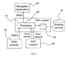
- Fig. 1 shows a system for robust position estimation according to an embodiment.
- the system will be described with the assumption that it relates to real-time GPS positioning; however, this does not exclude the possibility of implementing the system as a capture and process system.
- the system includes a WiFi locator device 10, which is intended to augment an existing GPS receiver 20 and navigation application 30. That is, in a conventional configuration, GPS receiver 20 would be connected directly to the navigation application 30. In the example, the communication between these two is via a NMEA (National Marine Electronics Association - NMEA 0183) interface.
- the WiFi locator 10 is designed to receive input from the GPS receiver 20 and output enhanced position data to the navigation application 10 via the existing NMEA interfaces of those respective devices.
- a WiFi modem 40 is also connected to the WiFi locator 10.
- the modem 40 can communicate with WiFi (WLAN) access points in the vicinity of the device. In particular, it can interrogate (either passively or actively) the APs to determine the identity (typically given by a MAC address) of each. Since each individual MAC address is unique, the set of APs visible at any given instant can be used to infer the location of the WiFi Locator device. The accuracy of this inference is fundamentally governed by the transmitter range of each AP as well as by the physical layout of the set of APs. However, the inference also depends on the availability of information cross-referencing or associating the AP identities with position. This information is collected by the device in a dynamic manner.
- the WiFi locator 10 includes a processor 50 and a memory 60.
- the processor receives data from both the WiFi modem 40 and the GPS receiver 20.
- the data received from the GPS receiver 20 consists of position information, such as geographic coordinates. It may also include additional information, such as the status of the GPS receiver 20 and the predicted error in the position estimates being provided.
- the position information provided by the GPS receiver comprises a primary, trusted position estimate. The GPS position will be used as a reference from which other estimates can be inferred (using WiFi positioning).
- the processor receives observations of WiFi APs from the WiFi modem 40. These consist of a list of MAC addresses of nearby wireless APs detected by the modem 40.
- the modem 40 may produce this list by an active or a passive scan. In an active scan, the APs are interrogated with a query by the modem 40. In a passive scan, the modem simply records broadcast AP identity information. Scans are initiated (requested) explicitly by the processor 50 in the WiFi Locator 10. By waiting until scans are explicitly triggered by the processor 50, rather than executing continual regular scans, the WiFi modem 40 saves power.
- the capacity of the memory 60 is also used more efficiently, since the triggered scans are chosen intelligently to correspond to the situations in which they are most useful to an individual user. That is, the scans are requested by the processor 50 in response to an indication that a WiFi position estimate is likely to be required subsequently. This indication can be derived from several sources, as will be described in greater detail below.
- the processor 50 stores the received position information and observations in the memory 60.
- the memory may comprise a simple buffer which stores as little as just one previous observation and position. Alternatively, it may store a longer history of recorded positions and observations.
- the processor 50 uses the stored history of GPS position estimates and WiFi AP observations to enhance the location estimates provided to the navigation application 30. By basing the estimates on the combined GPS and WiFi information, the WiFi locator 10 can offer more robust and/or faster position information than is available by using either alone. For example, if the GPS receiver 20 fails to provide a position estimate, but the WiFi modem nonetheless provides an observation, the processor can compare the current observation with a stored observation. If the comparison shows that a similar set of APs is visible, then the processor 50 provides the stored position information (corresponding to the stored AP observation) to the navigation application 30 as a location estimate.
- the content of the memory can be uploaded to a sharing service 70.
- This allows other devices or users to utilise the set of positions and observations collected by the device. This will be particularly beneficial where multiple devices are owned by the same user - the information stored by each device will be equally relevant to that user and can be used by each device as if collected by that device. If the information is shared among users, the individual relevance of the data may be reduced; however, it may be better to have the shared data of another user rather than none at all - for example when visiting a new location for the first time, before personally collected data are available in the database. Another possibility for users who own multiple location-aware devices will be to link all the devices to a single WiFi locator. That is, multiple navigation applications 30 can be enabled by a common WiFi locator 10.
- Fig. 2 shows a flowchart of a method according to a first embodiment of the invention. As before, this will be described in terms of a real-time GPS implementation.
- trusted that is, GPS
- the signal data comprises signals received from GPS satellites and is sufficient to enable a position to be calculated.
- the satellite signal data is received at a location A.
- an indication is received that a secondary position estimate is likely to be required in the vicinity of location A. This requirement could arise for various reasons: for example, because GPS signals are expected not to be available and/or because this location is of particular significance to the user.
- the indication can likewise be inferred from a number of sources.
- One useful indicator of the value of observations is the quality or possibility of the satellite position measurement itself.
- the indication might be a direct measurement of fading GPS reception, indicating that it will soon become impossible to compute a position fix. For example, when a position measurement via a GPS fix is no longer possible, the user is assumed to have moved from a good signal environment to a poor signal environment (for example walking through a doorway indoors). A sample observation of the sensed AP identities will give information about the environment in the vicinity of the doorway. Likewise, observations may be useful when the quality of the GPS fix is poor.
- the indication might be inferred from the activation or deactivation of the PND itself.
- a stage in the power down procedure of the PND could sample the signal environment, in order to recognise the environment and therefore likely location upon subsequent reactivation. For the same reasons, a sample can be triggered when switching on the device or location function.
- Detected movement patterns of the PND can also provide a valuable source of information. Movement can be detected as a result of measurements of position fix by GPS or by other means (for example, by an accelerometer).
- an observation may be sampled if the device is believed to have stopped moving. This is to gather a spot sample of the environment, in anticipation of possible movement into a difficult (for example, indoor) environment nearby. While the device remains stationary, further samples may be only taken at longer intervals (rather than continuously, or frequently), in case the environment changes. Sample observations may also be taken if the device is moving slowly, for example at walking speed.
- an observation of nearby WiFi beacons is obtained. It is not essential that this observation is carried out at the precise time or location of the reception of the satellite signal data; however, the reception and observation must be close enough together that there is a reasonably high confidence that the observed WiFi identities are the same as those that are observable from the actual location of reception of the satellite signals (location A). In practice, this will mean that - if the observation of WiFi beacons and reception of satellite signals is not synchronised - the latter occurs sufficiently frequently that it is still possible to establish a meaningful correspondence. This may depend on the expected dynamics of the user device. If the application is vehicle positioning, reception of GPS signals may need to be relatively frequent, compared to a pedestrian application, in order to work at the higher speeds involved.
- the result of the observation is a set of AP identities.
- the set of identities is stored in the memory 60, associated with the position of the corresponding GPS fix (location A).
- the accumulated data in the memory comprises a database, which can be used to support subsequent position estimation based on wireless AP visibility. That is, when the GPS signal is not available, the PND can once again sense the wireless environment and this time compare the observed APs with the entries in the accumulated database. Similarity between the new observation and one stored in the database (in terms of commonality between the sets of visible APs) implies that the user is at or near the previously visited location.
- the explicit position fix may not be available at the time the observation is entered (stored) in the database.
- the set of AP identities may be associated with the position by means of a label (such as: "unknown1").
- the IF signal data samples can then be stored associated with the same label, such that when they are later processed to extract explicit geographic coordinates, those coordinates can be associated with the corresponding stored observation.
- the steps of the method described above are re-ordered.
- the first step 110 is the receipt of the indication to sense the wireless environment and store an observation in the database.
- the sensing is executed, in response to the indication.
- the associated first information for the trusted (reference) estimate of position is obtained.
- the final step 130 consists of storing the observation result associated with the trusted position information. This sequence of steps is appropriate to the circumstances at the start of a journey, for example, before a first GPS fix has been achieved.
- step 120 of sensing the wireless AP identities is carried out in response to (and therefore after) the receipt of the indication to do so.
- step 120 of sensing the wireless AP identities is carried out in response to (and therefore after) the receipt of the indication to do so.
- step 120 of sensing the wireless AP identities is carried out in response to (and therefore after) the receipt of the indication to do so.
- Another obvious practical constraint is that the storage of the observation (identities) cannot take place until after they have been sensed.
- GPS positioning is just one example of the kind of trusted estimate from which the AP position database may be constructed.
- any available source of position information can be a valid trusted estimate.
- estimated positions based solely on WiFi AP sightings that is, position estimates exploiting previously stored observations
- This will, in effect, result in a "chain” of estimates, with "trusted” reference positions calculated from former estimates - which will invariably lead to reduced accuracy, the longer the chain.
- it may allow observation data to be created and associated with positions which are otherwise impossible to determine. This increases the coverage of the database. In many cases, this will be acceptable and certainly preferable to a complete inability to estimate a location.
- a user may arrive after a car journey at his destination and go inside a building.
- the PND senses wireless access point X just as it loses a GPS fix. Later, the user moves deeper into the building, where the PND observes AP-Y in addition to AP-X.
- the device is able to estimate its location as being that where AP-X was first seen and uses the last successful GPS fix (from the car-park) to derive this estimate. The observation of X+Y is stored associated with this estimate. Later still, sight of AP-X is lost but AP-Y is remains visible.
- the device can use the stored previous location estimate (derived when AP-Y and AP-X were both visible) as the basis for a secondary estimate.
- the accuracy of the estimate may be less than for the primary estimate (that is, the estimate directly associated with the GPS fix in the car park) but still places the user at the same street address. Thus, overall spatial coverage is increased.
- trusted position information is the use of manually input location as the trusted position data.
- manual input can take a variety of forms. For example a user could enter an address or postcode; this can then be used, together with a geographic information systems (GIS) database, to derive position coordinates. The user could also indicate their position graphically on a map - in its simplest form this might involve confirming to the PND that the position has not changed from the last available position fix.
- GIS geographic information systems
- the triggering of an observation may be followed by suppression of further observations.
- This additional step recognises that redundancy may be reintroduced if repeated samples of the environment are sensed in response to the same stimulus (that is, the trigger-indication). For example, once one observation has been made, it will be of limited value to take another WiFi sighting if the device is known to be stationary.
- a user switches on his personal navigation device (PND) at his home.
- the system samples the environment (in response to activation), making observations of nearby wireless APs, and starts up the GPS receiver.
- the user drives to a new destination (the system navigating on GPS). He arrives successfully and parks.
- the system samples the environment again (in response to having stopped), before the user turns the PND off.
- a further sample might be triggered by the power-off command, or this extra sample may be suppressed since a separate observation has already been taken very recently.
- the user turns on his PND indoors to find a route home. No GPS signal is available.
- the PND recognises the environment from a further AP observation - it is still the same as when it was last turned off - and so places him where he parked. He plans his journey to stop at a café down the road, goes to the car, and sets off.
- the GPS acquires the signals, and helps him complete his journey to the café. He goes inside, where the system picks up the new WiFi signals of another AP (the observation having been triggered as the GPS signal faded). His position is still shown on the PND - although the GPS signal has been lost, the system is now using the WiFi signals just found. Over a coffee, he works out his route home, and then drives home, turning off the PND once he is safely on the motorway.
- the next day he again gets in the car at home in his garage, ready to go to his next appointment. He switches on his PND.
- the system samples the environment to determine position since no GPS fix is yet available, recognises the home location (and not where he previously finished, on the motorway), and provides the coordinates to the navigation system, immediately ready to plan the day's route.
- This example scenario demonstrates the advantages of the current methods.
- the user has collected a small but highly relevant quantity of data relating AP observations with known positions. This can then be used to augment the GPS positioning system when conditions make it necessary. Since the stored information is related to the activity of the user, the information quality is higher than for a generically-surveyed database. Furthermore, all information is up-to-date (that is, current) and usable immediately. Observations are collected when they are most valuable or most likely to be needed. Moreover, such intelligent sampling can also eliminate or at least reduce the number of unnecessary observations - reducing power consumption and helping to prolong battery life.
- the invention is characterised by its lack of reliance on a previously populated or shared database. However, it is nonetheless possible to upload stored data to such a shared database for the benefit of other users. Data may also be downloaded from such a sharing service to augment the observations made by an individual PND itself. It may however be advantageous to use the individually collected data in preference to generic shared data, since the observations collected by the user's own device are likely to be more relevant to their usual navigation needs and habitual movements. In essence, the self-obtained data is personalised to a given user. When data are uploaded to a sharing service, the data may be labelled as corresponding to that user, both to protect privacy and to allow that data to later be prioritised (when re-used by the submitting user) over other data (submitted by strangers).
- the WiFi locator 10 of Fig. 1 becomes an intelligent logger.
- This device is operable to receive and store signal samples of the GPS satellite broadcast. It is also samples and stores observations of WiFi nodes nearby, in response to triggered scan requests. The logged data can then be provided to another device (including, but not limited to, a personal computer) for processing.
- the GPS receiver 20 comprises a GPS Radio Frequency (RF) front-end.
- RF Radio Frequency
- the WiFi modem 40 senses/interrogates the nearby access points to determine at least their identities, as before.
- the observations and IF data samples are stored in a memory 60, for later processing.
- the IF data and observations may be directly associated with one another, or may simply be stored with time-stamps to enable correspondence to be determined later.
- the stored information is transmitted to the device responsible for completing the processing (in the example of Fig. 1 , the navigation application 30).
- the offline processing may be carried out in the logger/locator 10, but at a convenient time - for example, processing only when logging has stopped, to normalise the power consumption of the device over time.
- the processing carried out is the same as that described above in the context of the real-time embodiments.
- a capture-and-process system is not limited to making causal inferences. That is, the observation and signal data or position information which forms the basis for a location estimate can come from any point in time - both prior and subsequent to the event/observation of interest.
- the observations may involve more detailed sampling of the environment than simply recording the identities of local wireless APs.
- Other parameters such as signal strength, direction of arrival and time delay could all be measured.
- Information relating to movement can also be useful - for example, velocity and time or distance and direction information can be combined in dead-reckoning navigation. This allows a (successful) position estimate to be projected into the future (or past).
- the scope of the invention is not limited exclusively to wireless LAN (WiFi) APs.
- Other terrestrial radio transmitters could fulfil the same function.
- analogue and digital broadcast radio and television transmissions can be observed, as can signals from cellular (mobile) telephony base stations.
- the identity of the transmitters can be used to infer connections between observations at different times and places.
- the beacons be fixed terrestrial transmitters (although processing and inference is likely to be more straightforward if they are).
- Bluetooth radio devices could be the observed wireless sources. Although many Bluetooth devices are portable, inferences will still be possible to a more limited extent. For example, one set of Bluetooth mobile devices may consistently be observed in the home environment and a second separate set may consistently be observed in the work environment. With longer historical storage of measurements and more advanced algorithms it will be possible to deduce with increasing certainty which sources are the most reliable or specific indicators.
- the embodiments of the invention rely on methods of computing similarity or "overlap" between different observations of wireless sources to establish associations and deduce the reference positions for estimating locations.
- methods of computing similarity or "overlap" between different observations of wireless sources to establish associations and deduce the reference positions for estimating locations.
- more advanced approaches to estimating reference positions in which multiple observations of wireless sources are combined to arrive at a position estimate will tend to be more accurate.
- the "similarity" of two sets of sensed sources could involve analysis of the size (strictly, the cardinality) of the intersection of the sets as compared to that of the set difference or symmetric difference. That is, a match is sought which has a large number of sources in common with the current observation and few extra or missing sources.
- set theory There are a wide variety of possible ways to define the similarity, using set theory, which will be readily apparent to the skilled person.
- moving signal sources such as WiFi nodes on trains
- sensed signals likely to be associated with a moving feature may be identified by detecting their appearance in many different "locations"; by detecting a high level of Doppler effect on some sensed signals; or by having the base-station announce that it is installed on a moving platform. Such signals may either be ignored for finding a stationary location or used to consider the hypothesis that the user is moving together with the signal source.
- GNSS Global Navigation Satellite Systems
Landscapes
- Engineering & Computer Science (AREA)
- Radar, Positioning & Navigation (AREA)
- Remote Sensing (AREA)
- Computer Networks & Wireless Communication (AREA)
- Signal Processing (AREA)
- Physics & Mathematics (AREA)
- General Physics & Mathematics (AREA)
- Position Fixing By Use Of Radio Waves (AREA)
- Navigation (AREA)
- Mobile Radio Communication Systems (AREA)
Applications Claiming Priority (2)
| Application Number | Priority Date | Filing Date | Title |
|---|---|---|---|
| GB0814355A GB2462592A (en) | 2008-08-06 | 2008-08-06 | Supplementing GPS position information adaptively with WiFi location data |
| PCT/GB2009/050977 WO2010015854A1 (en) | 2008-08-06 | 2009-08-05 | Robust location estimation |
Publications (2)
| Publication Number | Publication Date |
|---|---|
| EP2318855A1 EP2318855A1 (en) | 2011-05-11 |
| EP2318855B1 true EP2318855B1 (en) | 2013-10-02 |
Family
ID=39767583
Family Applications (1)
| Application Number | Title | Priority Date | Filing Date |
|---|---|---|---|
| EP09785447.5A Active EP2318855B1 (en) | 2008-08-06 | 2009-08-05 | Robust location estimation |
Country Status (7)
| Country | Link |
|---|---|
| US (1) | US9465095B2 (enExample) |
| EP (1) | EP2318855B1 (enExample) |
| JP (1) | JP5657539B2 (enExample) |
| CN (1) | CN102112891B (enExample) |
| GB (1) | GB2462592A (enExample) |
| TW (1) | TW201011327A (enExample) |
| WO (1) | WO2010015854A1 (enExample) |
Families Citing this family (35)
| Publication number | Priority date | Publication date | Assignee | Title |
|---|---|---|---|---|
| EP2469292B1 (en) | 2010-12-21 | 2017-02-08 | u-blox AG | Location estimation by observing wireless signals |
| EP2486423A1 (en) | 2009-10-05 | 2012-08-15 | BAE Systems Plc. | Improvements relating to navigation systems |
| US8295846B2 (en) * | 2010-03-02 | 2012-10-23 | Sony Corporation | GPS-based CE device wireless access point mapping |
| US8504061B2 (en) | 2010-04-07 | 2013-08-06 | Apple Inc. | Multi-tier geofence detection |
| DE102010029589B4 (de) | 2010-06-01 | 2024-08-22 | Bayerische Motoren Werke Aktiengesellschaft | Verfahren zur Bestimmung der Fahrzeugeigenposition eines Kraftfahrzeugs |
| CN101977423B (zh) * | 2010-10-19 | 2013-01-30 | 北京航空航天大学 | 一种车载WiFi设备选择访问点的方法 |
| US8396485B2 (en) | 2010-11-09 | 2013-03-12 | Apple Inc. | Beacon-based geofencing |
| CN102075297B (zh) * | 2011-01-25 | 2012-12-19 | 北京航空航天大学 | 一种基于移动预测的WiFi速率自适应选择方法 |
| DE102011006180A1 (de) * | 2011-03-25 | 2012-09-27 | Vodafone Holding Gmbh | Verfahren und System zum funkbasierten Lokalisieren eines Endgeräts |
| US8457882B2 (en) * | 2011-04-19 | 2013-06-04 | Honeywell International Inc. | Systems and methods for navigation in a GPS-denied environment |
| CN103649770B (zh) * | 2011-06-29 | 2016-08-24 | 皇家飞利浦有限公司 | 移动设备的位置估计 |
| US9432805B2 (en) * | 2011-09-28 | 2016-08-30 | Qualcomm Incorporated | Discovering and automatically sizing a place of relevance |
| US8682345B2 (en) * | 2011-09-28 | 2014-03-25 | Qualcomm Incorporated | Utilizing relationships between places of relevance |
| US9939264B2 (en) * | 2011-12-21 | 2018-04-10 | Verizon Telematics Inc. | Method and system for determining the height of a device above ground |
| US9143892B2 (en) * | 2012-03-09 | 2015-09-22 | Microsoft Technology Licensing, Llc | Wireless beacon filtering and untrusted data detection |
| US8914043B2 (en) * | 2012-04-18 | 2014-12-16 | Google Inc. | Creating and sharing private location databases |
| CN104350793B (zh) * | 2012-06-06 | 2019-04-19 | 脸谱公司 | 通常与位置跟踪有关的方法、一个或多个计算机可读非暂时性存储介质和装置 |
| US9088865B2 (en) * | 2012-06-06 | 2015-07-21 | Facebook, Inc. | Global-positioning system (GPS) update interval based on sensor |
| JP6067315B2 (ja) * | 2012-10-12 | 2017-01-25 | 富士通テン株式会社 | 車両制御装置、及び、車両制御方法 |
| US8838138B2 (en) * | 2012-12-28 | 2014-09-16 | Intel Corporation | Context aware geofencing |
| US9544741B2 (en) * | 2013-01-18 | 2017-01-10 | Panasonic Intellectual Property Management Co., Ltd. | Terminal |
| US9121711B2 (en) | 2013-03-15 | 2015-09-01 | Csr Technology Inc. | Environmental awareness for improved power consumption and responsiveness in positioning devices |
| EP2799909A1 (en) * | 2013-04-30 | 2014-11-05 | Thomson Licensing | Detection of a mobile device location |
| CN103308934B (zh) * | 2013-06-20 | 2015-05-13 | 上海无线电设备研究所 | 一种利用wifi反射信号实现室内移动人员定位的方法 |
| CN103686896B (zh) * | 2013-12-12 | 2016-06-15 | 广州市地下铁道总公司 | 无线接入点的切换方法和终端 |
| DE102014215570B4 (de) * | 2014-08-06 | 2021-12-30 | Elektrobit Automotive Gmbh | Fahrzeugnavigationssystem |
| DE102014014372A1 (de) | 2014-10-03 | 2016-04-07 | Iunera GmbH & Co. KG | System, Verfahren und Anordnungen zum Auffinden und Abspeichern von Dokumenten |
| CN107484118A (zh) * | 2016-06-07 | 2017-12-15 | 滴滴(中国)科技有限公司 | 一种基于建筑物WiFi指纹的室内场景定位方法及系统 |
| US10929081B1 (en) * | 2017-06-06 | 2021-02-23 | United Services Automobile Association (Usaa) | Context management for multiple devices |
| US10327103B2 (en) | 2017-10-20 | 2019-06-18 | Koninklijke Philips N.V. | Wireless location recognition for wearable device |
| CN109270566B (zh) * | 2018-09-17 | 2021-05-11 | 百度在线网络技术(北京)有限公司 | 导航方法、导航效果测试方法、装置、设备和介质 |
| CN111148216B (zh) * | 2019-03-27 | 2021-07-23 | 广东小天才科技有限公司 | 一种电子设备的定位方法及电子设备 |
| US11468760B2 (en) * | 2020-01-26 | 2022-10-11 | Instant Care, Inc. | Device for and method of sensing motion or lack-of-motion using data received from one or more sensors to turn on or off internal or external devices |
| CA3188303A1 (en) | 2020-06-26 | 2021-12-30 | Piper Networks, Inc. | Multi-sensor vehicle positioning system employing shared data protocol |
| CN116939500A (zh) * | 2022-03-31 | 2023-10-24 | 中兴通讯股份有限公司 | 一种追踪定位方法、装置、电子设备及存储介质 |
Family Cites Families (22)
| Publication number | Priority date | Publication date | Assignee | Title |
|---|---|---|---|---|
| FR501511A (fr) * | 1919-02-08 | 1920-04-16 | Edwin Howard Armstrong | Méthode de réception d'oscillations de haute fréquence |
| FI20030222L (fi) | 2003-02-13 | 2004-08-14 | Ekahau Oy | Paikannussovelluksia langattomia verkkoja varten |
| US7286609B2 (en) | 2003-08-08 | 2007-10-23 | Intel Corporation | Adaptive multicarrier wireless communication system, apparatus and associated methods |
| EP1673953A2 (en) * | 2003-10-01 | 2006-06-28 | LAIRD, Mark, D. | Wireless virtual campus escort system |
| DE112005001761T5 (de) | 2004-07-23 | 2007-05-24 | Wireless Valley Communications, Inc., Austin | System, Verfahren und Vorrichtung zum Bestimmen und Verwenden einer Position von drahtlosen Vorrichtungen oder einer Infrastruktur zur Verbesserung eines drahtlosen Netzes |
| KR101099151B1 (ko) | 2004-10-29 | 2011-12-27 | 스카이후크 와이어리스, 인크. | 위치 표지 데이터베이스와 서버, 위치 표지 데이터베이스구축 방법 및 이것을 이용한 위치 기반 서비스 |
| US7397424B2 (en) * | 2005-02-03 | 2008-07-08 | Mexens Intellectual Property Holding, Llc | System and method for enabling continuous geographic location estimation for wireless computing devices |
| US20060271517A1 (en) | 2005-05-25 | 2006-11-30 | Deloach James D Jr | User-driven calibration for location system |
| DE102005026788A1 (de) | 2005-06-10 | 2006-12-21 | Deutsche Telekom Ag | Verfahren und System zur Lokalisierung eines mobilen WLAN-Clients |
| US8099106B2 (en) * | 2005-08-24 | 2012-01-17 | Qualcomm Incorporated | Method and apparatus for classifying user morphology for efficient use of cell phone system resources |
| US7702821B2 (en) | 2005-09-15 | 2010-04-20 | Eye-Fi, Inc. | Content-aware digital media storage device and methods of using the same |
| KR101031205B1 (ko) | 2005-11-07 | 2011-04-27 | 퀄컴 인코포레이티드 | Wlan 네트워크 및 무선 네트워크에 대한 위치측정 |
| US7605752B2 (en) * | 2005-12-28 | 2009-10-20 | Gabriel Technologies Corp. | Apparatus and method for controlling autonomous and assisted GPS modes in a wireless mobile terminal |
| US7283095B2 (en) * | 2006-02-08 | 2007-10-16 | Northrop Grumman Corporation | Antenna assembly including z-pinning for electrical continuity |
| CA2657207A1 (en) * | 2006-07-07 | 2008-01-10 | Skyhook Wireless, Inc. | Systems and methods of gathering information from wlan-enabled access points to estimate position of a wlan positioning device |
| US7551126B2 (en) * | 2007-03-08 | 2009-06-23 | Trimble Navigation Limited | GNSS sample processor for determining the location of an event |
| US8331953B2 (en) | 2007-05-01 | 2012-12-11 | Andrew Llc | System and method for estimating the location of a mobile device |
| CN101311675A (zh) * | 2007-05-25 | 2008-11-26 | 佛山市顺德区汉达精密电子科技有限公司 | 可携式安全装置 |
| GB2460626A (en) | 2008-05-22 | 2009-12-09 | Geotate Bv | File creation system and method |
| US8804551B2 (en) | 2008-08-06 | 2014-08-12 | U-Blox Ag | Location estimation by observing wireless signals |
| US8965395B2 (en) | 2009-06-05 | 2015-02-24 | Qualcomm Incorporated | Positioning of user equipment in a wireless communication network |
| US8306552B2 (en) | 2009-12-10 | 2012-11-06 | Qualcomm Incorporated | Pattern filtering for mobile station position estimation |
-
2008
- 2008-08-06 GB GB0814355A patent/GB2462592A/en not_active Withdrawn
-
2009
- 2009-08-05 US US13/057,273 patent/US9465095B2/en active Active
- 2009-08-05 JP JP2011521644A patent/JP5657539B2/ja active Active
- 2009-08-05 CN CN200980130534.3A patent/CN102112891B/zh active Active
- 2009-08-05 TW TW098126357A patent/TW201011327A/zh unknown
- 2009-08-05 WO PCT/GB2009/050977 patent/WO2010015854A1/en not_active Ceased
- 2009-08-05 EP EP09785447.5A patent/EP2318855B1/en active Active
Also Published As
| Publication number | Publication date |
|---|---|
| GB0814355D0 (en) | 2008-09-10 |
| JP2011530079A (ja) | 2011-12-15 |
| US20110128183A1 (en) | 2011-06-02 |
| WO2010015854A1 (en) | 2010-02-11 |
| US9465095B2 (en) | 2016-10-11 |
| JP5657539B2 (ja) | 2015-01-21 |
| GB2462592A (en) | 2010-02-17 |
| CN102112891B (zh) | 2014-03-19 |
| TW201011327A (en) | 2010-03-16 |
| EP2318855A1 (en) | 2011-05-11 |
| CN102112891A (zh) | 2011-06-29 |
Similar Documents
| Publication | Publication Date | Title |
|---|---|---|
| EP2318855B1 (en) | Robust location estimation | |
| US8804551B2 (en) | Location estimation by observing wireless signals | |
| US10469983B2 (en) | System and method for device-centric location detection and geofencing | |
| US9395445B2 (en) | Intermittent tracking for GNSS | |
| EP2248120B1 (en) | Position source selection | |
| EP2449411B1 (en) | Trajectory-based location determination | |
| US9103917B2 (en) | Method and system for determining location within a building based on historical location information | |
| US20130116966A1 (en) | Determination of a location of an apparatus | |
| CN102223596A (zh) | 一种移动定位服务方法 | |
| CN102223706A (zh) | 一种移动定位服务系统 | |
| CN102223597A (zh) | 一种移动定位装置 | |
| AU2006225107A1 (en) | GPS position tracking method with variable updating rate for power conservation | |
| CN104040371A (zh) | 给移动站的位置估计辅助信息 | |
| CN102469500A (zh) | 一种基于无线传感技术的移动定位服务方法 | |
| CN102469580A (zh) | 一种基于无线传感技术的移动定位服务系统 | |
| CN102223707A (zh) | 一种移动定位信标装置 | |
| US7860517B1 (en) | Mobile device tracking using mobile agent location breadcrumbs | |
| CN102469581A (zh) | 一种基于无线传感技术的移动定位装置 | |
| JP2022180318A (ja) | 動的な位置データサンプリングによる信号損失及び方向の曖昧さの低減 |
Legal Events
| Date | Code | Title | Description |
|---|---|---|---|
| PUAI | Public reference made under article 153(3) epc to a published international application that has entered the european phase |
Free format text: ORIGINAL CODE: 0009012 |
|
| 17P | Request for examination filed |
Effective date: 20110302 |
|
| AK | Designated contracting states |
Kind code of ref document: A1 Designated state(s): AT BE BG CH CY CZ DE DK EE ES FI FR GB GR HR HU IE IS IT LI LT LU LV MC MK MT NL NO PL PT RO SE SI SK SM TR |
|
| AX | Request for extension of the european patent |
Extension state: AL BA RS |
|
| DAX | Request for extension of the european patent (deleted) | ||
| 17Q | First examination report despatched |
Effective date: 20120227 |
|
| REG | Reference to a national code |
Ref country code: DE Ref legal event code: R079 Ref document number: 602009019221 Country of ref document: DE Free format text: PREVIOUS MAIN CLASS: G01S0005020000 Ipc: G01S0019480000 |
|
| GRAP | Despatch of communication of intention to grant a patent |
Free format text: ORIGINAL CODE: EPIDOSNIGR1 |
|
| RIC1 | Information provided on ipc code assigned before grant |
Ipc: G01S 5/02 20100101ALI20130125BHEP Ipc: G01S 19/48 20100101AFI20130125BHEP |
|
| GRAS | Grant fee paid |
Free format text: ORIGINAL CODE: EPIDOSNIGR3 |
|
| GRAA | (expected) grant |
Free format text: ORIGINAL CODE: 0009210 |
|
| AK | Designated contracting states |
Kind code of ref document: B1 Designated state(s): AT BE BG CH CY CZ DE DK EE ES FI FR GB GR HR HU IE IS IT LI LT LU LV MC MK MT NL NO PL PT RO SE SI SK SM TR |
|
| REG | Reference to a national code |
Ref country code: GB Ref legal event code: FG4D |
|
| REG | Reference to a national code |
Ref country code: CH Ref legal event code: EP Ref country code: AT Ref legal event code: REF Ref document number: 634873 Country of ref document: AT Kind code of ref document: T Effective date: 20131015 |
|
| REG | Reference to a national code |
Ref country code: IE Ref legal event code: FG4D |
|
| REG | Reference to a national code |
Ref country code: NL Ref legal event code: T3 |
|
| REG | Reference to a national code |
Ref country code: DE Ref legal event code: R096 Ref document number: 602009019221 Country of ref document: DE Effective date: 20131128 |
|
| REG | Reference to a national code |
Ref country code: AT Ref legal event code: MK05 Ref document number: 634873 Country of ref document: AT Kind code of ref document: T Effective date: 20131002 |
|
| PG25 | Lapsed in a contracting state [announced via postgrant information from national office to epo] |
Ref country code: SI Free format text: LAPSE BECAUSE OF FAILURE TO SUBMIT A TRANSLATION OF THE DESCRIPTION OR TO PAY THE FEE WITHIN THE PRESCRIBED TIME-LIMIT Effective date: 20131002 |
|
| REG | Reference to a national code |
Ref country code: LT Ref legal event code: MG4D |
|
| PG25 | Lapsed in a contracting state [announced via postgrant information from national office to epo] |
Ref country code: HR Free format text: LAPSE BECAUSE OF FAILURE TO SUBMIT A TRANSLATION OF THE DESCRIPTION OR TO PAY THE FEE WITHIN THE PRESCRIBED TIME-LIMIT Effective date: 20131002 Ref country code: NO Free format text: LAPSE BECAUSE OF FAILURE TO SUBMIT A TRANSLATION OF THE DESCRIPTION OR TO PAY THE FEE WITHIN THE PRESCRIBED TIME-LIMIT Effective date: 20140102 Ref country code: CZ Free format text: LAPSE BECAUSE OF FAILURE TO SUBMIT A TRANSLATION OF THE DESCRIPTION OR TO PAY THE FEE WITHIN THE PRESCRIBED TIME-LIMIT Effective date: 20131002 Ref country code: SE Free format text: LAPSE BECAUSE OF FAILURE TO SUBMIT A TRANSLATION OF THE DESCRIPTION OR TO PAY THE FEE WITHIN THE PRESCRIBED TIME-LIMIT Effective date: 20131002 Ref country code: LT Free format text: LAPSE BECAUSE OF FAILURE TO SUBMIT A TRANSLATION OF THE DESCRIPTION OR TO PAY THE FEE WITHIN THE PRESCRIBED TIME-LIMIT Effective date: 20131002 Ref country code: BE Free format text: LAPSE BECAUSE OF FAILURE TO SUBMIT A TRANSLATION OF THE DESCRIPTION OR TO PAY THE FEE WITHIN THE PRESCRIBED TIME-LIMIT Effective date: 20131002 Ref country code: FI Free format text: LAPSE BECAUSE OF FAILURE TO SUBMIT A TRANSLATION OF THE DESCRIPTION OR TO PAY THE FEE WITHIN THE PRESCRIBED TIME-LIMIT Effective date: 20131002 Ref country code: IS Free format text: LAPSE BECAUSE OF FAILURE TO SUBMIT A TRANSLATION OF THE DESCRIPTION OR TO PAY THE FEE WITHIN THE PRESCRIBED TIME-LIMIT Effective date: 20140202 |
|
| PG25 | Lapsed in a contracting state [announced via postgrant information from national office to epo] |
Ref country code: PL Free format text: LAPSE BECAUSE OF FAILURE TO SUBMIT A TRANSLATION OF THE DESCRIPTION OR TO PAY THE FEE WITHIN THE PRESCRIBED TIME-LIMIT Effective date: 20131002 Ref country code: AT Free format text: LAPSE BECAUSE OF FAILURE TO SUBMIT A TRANSLATION OF THE DESCRIPTION OR TO PAY THE FEE WITHIN THE PRESCRIBED TIME-LIMIT Effective date: 20131002 Ref country code: LV Free format text: LAPSE BECAUSE OF FAILURE TO SUBMIT A TRANSLATION OF THE DESCRIPTION OR TO PAY THE FEE WITHIN THE PRESCRIBED TIME-LIMIT Effective date: 20131002 Ref country code: CY Free format text: LAPSE BECAUSE OF FAILURE TO SUBMIT A TRANSLATION OF THE DESCRIPTION OR TO PAY THE FEE WITHIN THE PRESCRIBED TIME-LIMIT Effective date: 20131002 Ref country code: ES Free format text: LAPSE BECAUSE OF FAILURE TO SUBMIT A TRANSLATION OF THE DESCRIPTION OR TO PAY THE FEE WITHIN THE PRESCRIBED TIME-LIMIT Effective date: 20131002 |
|
| PG25 | Lapsed in a contracting state [announced via postgrant information from national office to epo] |
Ref country code: PT Free format text: LAPSE BECAUSE OF FAILURE TO SUBMIT A TRANSLATION OF THE DESCRIPTION OR TO PAY THE FEE WITHIN THE PRESCRIBED TIME-LIMIT Effective date: 20140203 |
|
| REG | Reference to a national code |
Ref country code: DE Ref legal event code: R097 Ref document number: 602009019221 Country of ref document: DE |
|
| PG25 | Lapsed in a contracting state [announced via postgrant information from national office to epo] |
Ref country code: EE Free format text: LAPSE BECAUSE OF FAILURE TO SUBMIT A TRANSLATION OF THE DESCRIPTION OR TO PAY THE FEE WITHIN THE PRESCRIBED TIME-LIMIT Effective date: 20131002 |
|
| REG | Reference to a national code |
Ref country code: CH Ref legal event code: PLX |
|
| PLBE | No opposition filed within time limit |
Free format text: ORIGINAL CODE: 0009261 |
|
| STAA | Information on the status of an ep patent application or granted ep patent |
Free format text: STATUS: NO OPPOSITION FILED WITHIN TIME LIMIT |
|
| PG25 | Lapsed in a contracting state [announced via postgrant information from national office to epo] |
Ref country code: SK Free format text: LAPSE BECAUSE OF FAILURE TO SUBMIT A TRANSLATION OF THE DESCRIPTION OR TO PAY THE FEE WITHIN THE PRESCRIBED TIME-LIMIT Effective date: 20131002 Ref country code: IT Free format text: LAPSE BECAUSE OF FAILURE TO SUBMIT A TRANSLATION OF THE DESCRIPTION OR TO PAY THE FEE WITHIN THE PRESCRIBED TIME-LIMIT Effective date: 20131002 Ref country code: RO Free format text: LAPSE BECAUSE OF FAILURE TO SUBMIT A TRANSLATION OF THE DESCRIPTION OR TO PAY THE FEE WITHIN THE PRESCRIBED TIME-LIMIT Effective date: 20131002 |
|
| 26N | No opposition filed |
Effective date: 20140703 |
|
| PG25 | Lapsed in a contracting state [announced via postgrant information from national office to epo] |
Ref country code: DK Free format text: LAPSE BECAUSE OF FAILURE TO SUBMIT A TRANSLATION OF THE DESCRIPTION OR TO PAY THE FEE WITHIN THE PRESCRIBED TIME-LIMIT Effective date: 20131002 |
|
| REG | Reference to a national code |
Ref country code: DE Ref legal event code: R097 Ref document number: 602009019221 Country of ref document: DE Effective date: 20140703 |
|
| PG25 | Lapsed in a contracting state [announced via postgrant information from national office to epo] |
Ref country code: CH Free format text: LAPSE BECAUSE OF THE APPLICANT RENOUNCES Effective date: 20131002 Ref country code: LI Free format text: LAPSE BECAUSE OF THE APPLICANT RENOUNCES Effective date: 20131002 |
|
| PG25 | Lapsed in a contracting state [announced via postgrant information from national office to epo] |
Ref country code: MC Free format text: LAPSE BECAUSE OF FAILURE TO SUBMIT A TRANSLATION OF THE DESCRIPTION OR TO PAY THE FEE WITHIN THE PRESCRIBED TIME-LIMIT Effective date: 20131002 Ref country code: LU Free format text: LAPSE BECAUSE OF FAILURE TO SUBMIT A TRANSLATION OF THE DESCRIPTION OR TO PAY THE FEE WITHIN THE PRESCRIBED TIME-LIMIT Effective date: 20140805 |
|
| REG | Reference to a national code |
Ref country code: GB Ref legal event code: S28 Free format text: APPLICATION FILED |
|
| GBPC | Gb: european patent ceased through non-payment of renewal fee |
Effective date: 20140805 |
|
| REG | Reference to a national code |
Ref country code: IE Ref legal event code: MM4A |
|
| REG | Reference to a national code |
Ref country code: GB Ref legal event code: S28 Free format text: RESTORATION ALLOWED Effective date: 20150706 |
|
| PG25 | Lapsed in a contracting state [announced via postgrant information from national office to epo] |
Ref country code: GB Free format text: LAPSE BECAUSE OF NON-PAYMENT OF DUE FEES Effective date: 20140805 |
|
| PG25 | Lapsed in a contracting state [announced via postgrant information from national office to epo] |
Ref country code: IE Free format text: LAPSE BECAUSE OF NON-PAYMENT OF DUE FEES Effective date: 20140805 |
|
| PGFP | Annual fee paid to national office [announced via postgrant information from national office to epo] |
Ref country code: NL Payment date: 20150830 Year of fee payment: 7 |
|
| PG25 | Lapsed in a contracting state [announced via postgrant information from national office to epo] |
Ref country code: NO Free format text: LAPSE BECAUSE OF FAILURE TO SUBMIT A TRANSLATION OF THE DESCRIPTION OR TO PAY THE FEE WITHIN THE PRESCRIBED TIME-LIMIT Effective date: 20140101 Ref country code: SM Free format text: LAPSE BECAUSE OF FAILURE TO SUBMIT A TRANSLATION OF THE DESCRIPTION OR TO PAY THE FEE WITHIN THE PRESCRIBED TIME-LIMIT Effective date: 20131002 |
|
| PG25 | Lapsed in a contracting state [announced via postgrant information from national office to epo] |
Ref country code: MT Free format text: LAPSE BECAUSE OF FAILURE TO SUBMIT A TRANSLATION OF THE DESCRIPTION OR TO PAY THE FEE WITHIN THE PRESCRIBED TIME-LIMIT Effective date: 20131002 Ref country code: GR Free format text: LAPSE BECAUSE OF FAILURE TO SUBMIT A TRANSLATION OF THE DESCRIPTION OR TO PAY THE FEE WITHIN THE PRESCRIBED TIME-LIMIT Effective date: 20140103 Ref country code: BG Free format text: LAPSE BECAUSE OF FAILURE TO SUBMIT A TRANSLATION OF THE DESCRIPTION OR TO PAY THE FEE WITHIN THE PRESCRIBED TIME-LIMIT Effective date: 20131002 |
|
| PG25 | Lapsed in a contracting state [announced via postgrant information from national office to epo] |
Ref country code: TR Free format text: LAPSE BECAUSE OF FAILURE TO SUBMIT A TRANSLATION OF THE DESCRIPTION OR TO PAY THE FEE WITHIN THE PRESCRIBED TIME-LIMIT Effective date: 20131002 Ref country code: HU Free format text: LAPSE BECAUSE OF FAILURE TO SUBMIT A TRANSLATION OF THE DESCRIPTION OR TO PAY THE FEE WITHIN THE PRESCRIBED TIME-LIMIT; INVALID AB INITIO Effective date: 20090805 |
|
| REG | Reference to a national code |
Ref country code: FR Ref legal event code: PLFP Year of fee payment: 8 |
|
| REG | Reference to a national code |
Ref country code: NL Ref legal event code: MM Effective date: 20160901 |
|
| PG25 | Lapsed in a contracting state [announced via postgrant information from national office to epo] |
Ref country code: NL Free format text: LAPSE BECAUSE OF NON-PAYMENT OF DUE FEES Effective date: 20160901 |
|
| REG | Reference to a national code |
Ref country code: FR Ref legal event code: PLFP Year of fee payment: 9 |
|
| PG25 | Lapsed in a contracting state [announced via postgrant information from national office to epo] |
Ref country code: MK Free format text: LAPSE BECAUSE OF FAILURE TO SUBMIT A TRANSLATION OF THE DESCRIPTION OR TO PAY THE FEE WITHIN THE PRESCRIBED TIME-LIMIT Effective date: 20131002 |
|
| REG | Reference to a national code |
Ref country code: FR Ref legal event code: PLFP Year of fee payment: 10 |
|
| P01 | Opt-out of the competence of the unified patent court (upc) registered |
Effective date: 20230506 |
|
| PGFP | Annual fee paid to national office [announced via postgrant information from national office to epo] |
Ref country code: DE Payment date: 20250820 Year of fee payment: 17 |
|
| PGFP | Annual fee paid to national office [announced via postgrant information from national office to epo] |
Ref country code: GB Payment date: 20250820 Year of fee payment: 17 |
|
| PGFP | Annual fee paid to national office [announced via postgrant information from national office to epo] |
Ref country code: FR Payment date: 20250829 Year of fee payment: 17 |