EP2247922B1 - Bestimmung von koordinaten eines ziels in bezug auf ein vermessungsinstrument mit mindestens zwei kameras - Google Patents
Bestimmung von koordinaten eines ziels in bezug auf ein vermessungsinstrument mit mindestens zwei kameras Download PDFInfo
- Publication number
- EP2247922B1 EP2247922B1 EP08717303.5A EP08717303A EP2247922B1 EP 2247922 B1 EP2247922 B1 EP 2247922B1 EP 08717303 A EP08717303 A EP 08717303A EP 2247922 B1 EP2247922 B1 EP 2247922B1
- Authority
- EP
- European Patent Office
- Prior art keywords
- image
- camera
- target
- coordinates
- object point
- Prior art date
- Legal status (The legal status is an assumption and is not a legal conclusion. Google has not performed a legal analysis and makes no representation as to the accuracy of the status listed.)
- Active
Links
Images



Classifications
-
- G—PHYSICS
- G06—COMPUTING OR CALCULATING; COUNTING
- G06T—IMAGE DATA PROCESSING OR GENERATION, IN GENERAL
- G06T7/00—Image analysis
- G06T7/50—Depth or shape recovery
- G06T7/55—Depth or shape recovery from multiple images
-
- G—PHYSICS
- G01—MEASURING; TESTING
- G01C—MEASURING DISTANCES, LEVELS OR BEARINGS; SURVEYING; NAVIGATION; GYROSCOPIC INSTRUMENTS; PHOTOGRAMMETRY OR VIDEOGRAMMETRY
- G01C1/00—Measuring angles
- G01C1/02—Theodolites
- G01C1/04—Theodolites combined with cameras
-
- G—PHYSICS
- G01—MEASURING; TESTING
- G01C—MEASURING DISTANCES, LEVELS OR BEARINGS; SURVEYING; NAVIGATION; GYROSCOPIC INSTRUMENTS; PHOTOGRAMMETRY OR VIDEOGRAMMETRY
- G01C11/00—Photogrammetry or videogrammetry, e.g. stereogrammetry; Photographic surveying
- G01C11/04—Interpretation of pictures
- G01C11/06—Interpretation of pictures by comparison of two or more pictures of the same area
-
- G—PHYSICS
- G01—MEASURING; TESTING
- G01C—MEASURING DISTANCES, LEVELS OR BEARINGS; SURVEYING; NAVIGATION; GYROSCOPIC INSTRUMENTS; PHOTOGRAMMETRY OR VIDEOGRAMMETRY
- G01C15/00—Surveying instruments or accessories not provided for in groups G01C1/00 - G01C13/00
- G01C15/002—Active optical surveying means
Definitions
- the present invention relates to surveying instruments, such as total stations. More particularly, the present invention relates to a method for determining coordinates of a target in relation to a surveying instrument having at least two cameras for capturing a field of view and at least one identified target point within the field of view.
- Surveying instruments of this kind i.e. which includes a camera, are sometimes referred to as video-theodolites.
- EDM electronic distance measuring
- the present invention provides a method for determining coordinates of a target in relation to a surveying instrument according to claim 1.
- FIG. 1 illustrates schematically a situation where an object point relating to a target P is identified in an image captured by a camera in a surveying instrument.
- a camera sensor 101 such as a CMOS camera or a CCD
- An image is formed on the camera sensor 101 by means of an optical system 103.
- the surveying instrument can be aimed at a desired target by rotation over horizontal and vertical angles about a rotation center 104 of the instrument.
- the optical system 103 for the camera is eccentric with respect to the rotation center of the instrument (separation eq and e l , respectively, from the rotation center of the instrument).
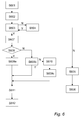
- first image coordinates of the object point in the first image are measured in a step S403.
- coordinates of the target P in relation to the rotation center O of the surveying instrument are determined based on the first camera position and orientation, the first image coordinates, the second camera position and orientation, the second image coordinates, and first and second camera calibration data.Thus, a first image and a second image are captured by the first camera and the second camera, respectively. Image coordinates for the object point are measured in the images and target coordinates of the target in relation to the instrument rotation center can be determined using respective camera calibration data.
- second coordinates of the object point in the second image are measured in a step S611.
- Coordinates of the target in relation to the rotation center of the surveying instrument are determined based on the first camera position and orientation, the first image coordinates, the second camera position and orientation, the second image coordinates, and first and second camera calibration data.
- a target direction from the rotation center of the surveying instrument is determined based on the determined target coordinates in relation to the rotation center of the surveying instrument. That is, the coordinates of the target are expressed in relation to the coordinate system of the surveying instrument.
- the target coordinates are typically related to a coordinate system having its origin at the rotation center of the surveying instrument.
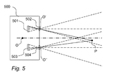
- a first image is captured by the first camera, when the first camera center is located in a first position O' eccentric to the location O of the rotation center of the surveying instrument and the first camera having a first camera orientation.
- a target in position P is selected by identifying an object point in a position P'(x', y') in the first image.
- the distance between the first camera and the second camera is denoted d c .
- a second image is captured by the second camera, the second camera center being located in the second position O" eccentric to the location O of the rotation center of the surveying instrument and the second camera having the second camera orientation.
- the object point identified in the first image is identified in the second image in a position P"(x", y").
- collinearity equations are used to estimate the coordinates of P.
- collinearity equations For a background of the deriving of the collinearity equations and of calibration of a camera reference is made to WO 2005/059473 .
- a section of r' can then be transformed into a section of a so called epipolar line EPL in the second image on which the object point should be located in the second image.
- a pattern may be recognized in the first image around the position P' of the object point in the first image, this pattern may be recognized in the second image, e.g. by means of automatic image processing, by searching along the section of the epipolar line in the second image or in an area around that section.
- the identification can be simplified by graphical indication of the section of the epipolar line in the second image.
Landscapes
- Engineering & Computer Science (AREA)
- Physics & Mathematics (AREA)
- General Physics & Mathematics (AREA)
- Radar, Positioning & Navigation (AREA)
- Remote Sensing (AREA)
- Multimedia (AREA)
- Computer Vision & Pattern Recognition (AREA)
- Theoretical Computer Science (AREA)
- Length Measuring Devices By Optical Means (AREA)
Claims (14)
- Verfahren zur Bestimmung von Koordinaten eines Ziels (P) in Bezug auf ein Vermessungsinstrument (500) mit einer ersten Kamera (501, 502) in einer ersten Kameraposition und -ausrichtung und einer zweiten Kamera (503, 504) in einer zweiten Kameraposition und - ausrichtung, umfassend:Erfassen (S401, S601) eines ersten Bildes unter Verwendung der ersten Kamera;Auswählen (S402, S602) eines Ziels durch Identifizieren mindestens eines Objektpunkts im ersten Bild;Messen (S403, S601) von ersten Bildkoordinaten des mindestens einen Objektpunkts im ersten Bild;Erfassen (S401, S601) eines zweiten Bildes unter Verwendung der zweiten Kamera;Identifizieren (S404, S609a, S609b) im zweiten Bild des mindestens einen im ersten Bild identifizierten Objektpunkts, ferner umfassend:Auswählen eines Mindestabstands (Dmin) und eines Höchstabstands (Dmax) von der ersten Kameraposition entlang des Abbildungsstrahls des Ziels im ersten Bild, wobei sich das Ziel zwischen dem Mindestabstand und Höchstabstand befindet;Bestimmen einer Teilstrecke einer Epipolarlinie (EPL) im zweiten Bild, auf der sich der mindestens eine Objektpunkt befindet, basierend auf dem Höchstabstand, dem Mindestabstand, der ersten Kameraposition und -ausrichtung, der zweiten Kameraposition und -ausrichtung, den ersten Bildkoordinaten und ersten und zweiten Kamerakalibrierdaten; undIdentifizieren (S404, S609a) entlang der Teilstrecke der Epipolarlinie im zweiten Bild des mindestens einen im ersten Bild identifizierten Objektpunkts;Messen (S405, S611) von zweiten Bildkoordinaten des mindestens einen Objektpunkts im zweiten Bild; undBestimmen (S406) von Zielkoordinaten des Ziels in Bezug auf den Drehmittelpunkt des Vermessungsinstruments basierend auf der ersten Kameraposition und -ausrichtung, den ersten Bildkoordinaten, der zweiten Kameraposition und -ausrichtung, den zweiten Bildkoordinaten und ersten und zweiten Kamerakalibrierdaten.
- Verfahren nach Anspruch 1, ferner umfassend:Bestimmen, ob die Epipolarlinie vollständig innerhalb des zweiten Bildes ist.
- Verfahren nach Anspruch 2, ferner umfassend:Drehen, wenn die Epipolarlinie nicht vollständig innerhalb des zweiten Bildes ist, des Vermessungsinstruments um den Drehmittelpunkt basierend auf Epipolarliniendaten, der zweiten Kameraposition und - ausrichtung und zweiten Kamerakalibrierdaten in eine revidierte zweite Kameraposition und -ausrichtung, um die Eipipolarlinie innerhalb eines revidierten zweiten Bildes zu positionieren;Erfassen des revidierten zweiten Bildes unter Verwendung der Kamera in der revidierten zweiten Position und Ausrichtung; undIdentifizieren entlang der Teilstrecke der Epipolarlinie im revidierten zweiten Bild des mindestens einen im ersten Bild identifizierten Objektpunkts.
- Verfahren nach einem der Ansprüche 1 bis 3, wobei der Mindestabstand als der Mindestabstand des Vermessungsinstruments ausgewählt wird.
- Verfahren nach einem der Ansprüche 1 bis 4, wobei das erste und zweite Bild erfasst werden, während das Ziel mittels einer Lichtquelle beleuchtet wird, und zwei weitere Bilder bei ausgeschalteter Lichtquelle erfasst werden, wobei eines der beiden Bilder der ersten Kamera vom anderen der beiden Bilder der ersten Kamera subtrahiert wird, um ein erstes Differenzbild zu erzeugen, und eines der beiden Bilder der zweiten Kamera vom anderen der beiden Bilder der zweiten Kamera subtrahiert wird, um ein zweites Differenzbild zu erzeugen;
und wobei
das Ziel durch Identifizieren mindestens eines Objektpunkts im ersten Differenzbild ausgewählt wird;
erste Bildkoordinaten des mindestens einen Objektpunkts im ersten Differenzbild gemessen werden;
der mindestens eine im ersten Differenzbild identifizierte Objektpunkt im zweiten Differenzbild identifiziert wird;
zweite Bildkoordinaten des mindestens einen Objektpunkts im zweiten Differenzbild gemessen werden; und
Zielkoordinaten des Ziels in Bezug auf den Drehmittelpunkt des Vermessungsinstruments basierend auf der ersten Kameraposition und -ausrichtung, den ersten Differenzbildkoordinaten, der zweiten Kameraposition und -ausrichtung, den zweiten Differenzbildkoordinaten und ersten und zweiten Kamerakalibrierdaten bestimmt werden. - Verfahren nach Anspruch 5, wobei die Lichtquelle das Ziel durch einen Fleck oder ein projiziertes Muster emittiert.
- Verfahren nach einem der Ansprüche 1 bis 6, wobei eine Anzahl von Bildern mit den zwei Kameras erfasst wird, um eine Abtastfunktion zu erreichen, wobei ein Bild der ersten Kamera mit einem entsprechenden Bild der zweiten Kamera verarbeitet wird, um Zielkoordinaten für jedes Paar von erfassten ersten und zweiten Bildern zu bestimmen.
- Verfahren nach einem der Ansprüche 1 bis 7, ferner umfassend:Bestimmen einer Richtung vom Drehmittelpunkt des Vermessungsinstruments zum Ziel basierend auf den bestimmten Zielkoordinaten.
- Verfahren nach Anspruch 8, ferner umfassend:Drehen des Vermessungsinstruments, so dass eine Sichtlinie des Vermessungsinstruments in Richtung Ziel gerichtet wird.
- Vermessungsinstrument, umfassend:eine erste Kamera, die so ausgelegt ist, dass sie Bilder aus einer ersten Position und Ausrichtung erfasst;eine zweite Kamera, die so ausgelegt ist, dass sie Bilder aus einer zweiten Position und Ausrichtung erfasst;Mittel zum Anzeigen von Bildern, die von der ersten Kamera und der zweiten Kamera erfasst werden;Mittel zum Identifizieren eines Objektpunkts, der einem ausgewählten Ziel in den angezeigten Bildern entspricht, wobei das Mittel zum Identifizieren ausgelegt ist zum:Auswählen eines Mindestabstands und eines Höchstabstands von der ersten Kameraposition entlang des Abbildungsstrahls des Ziels im ersten Bild, wobei sich das Ziel zwischen dem Mindestabstand und Höchstabstand befindet;Bestimmen einer Teilstrecke einer Epipolarlinie im zweiten Bild, auf der sich der mindestens eine Objektpunkt befindet, basierend auf dem Höchstabstand, dem Mindestabstand, der ersten Kameraposition und -ausrichtung, der zweiten Kameraposition und -ausrichtung, den ersten Bildkoordinaten und ersten und zweiten Kamerakalibrierdaten; undIdentifizieren entlang der Teilstrecke der Epipolarlinie im zweiten Bild des mindestens einen im ersten Bild identifizierten Objektpunkts;Messen von Bildkoordinaten des mindestens einen Objektpunkts in den angezeigten Bildern; undMittel zum Messen von Bildkoordinaten des Objektpunkts in den angezeigten Bildern; undMittel zum Bestimmen von Zielkoordinaten des Ziels in Bezug auf den Drehmittelpunkt des Vermessungsinstruments basierend auf der ersten Kameraposition und -ausrichtung, den ersten Bildkoordinaten, der zweiten Kameraposition und -ausrichtung, den zweiten Bildkoordinaten und Kamerakalibrierdaten.
- Instrument nach Anspruch 10, wobei das Mittel zum Identifizieren eines Objektpunkts als ein Cursor implementiert ist, der über die angezeigten Bilder bewegt werden kann.
- Instrument nach einem der Ansprüche 10 und 11, wobei das Mittel zum Identifizieren eines Objektpunkts unter Verwendung einer Berührungsanzeige implementiert ist, wobei der Objektpunkt durch Klicken oder Tippen auf die Anzeige identifiziert werden kann.
- Instrument nach einem der Ansprüche 10 bis 12, ferner umfassend:Mittel zum Beleuchten des ausgewählten Ziels.
- Instrument nach Anspruch 13, wobei das Mittel zum Beleuchten des ausgewählten Ziels koaxial zum Mittel zum Emittieren von Lichtimpulsen zum Ziel angeordnet ist.
Applications Claiming Priority (1)
| Application Number | Priority Date | Filing Date | Title |
|---|---|---|---|
| PCT/EP2008/052531 WO2009106141A1 (en) | 2008-02-29 | 2008-02-29 | Determining coordinates of a target in relation to a survey instrument having at least two cameras |
Publications (2)
| Publication Number | Publication Date |
|---|---|
| EP2247922A1 EP2247922A1 (de) | 2010-11-10 |
| EP2247922B1 true EP2247922B1 (de) | 2015-03-25 |
Family
ID=39946811
Family Applications (1)
| Application Number | Title | Priority Date | Filing Date |
|---|---|---|---|
| EP08717303.5A Active EP2247922B1 (de) | 2008-02-29 | 2008-02-29 | Bestimmung von koordinaten eines ziels in bezug auf ein vermessungsinstrument mit mindestens zwei kameras |
Country Status (4)
| Country | Link |
|---|---|
| US (1) | US9189858B2 (de) |
| EP (1) | EP2247922B1 (de) |
| CN (1) | CN101970985B (de) |
| WO (1) | WO2009106141A1 (de) |
Families Citing this family (74)
| Publication number | Priority date | Publication date | Assignee | Title |
|---|---|---|---|---|
| WO2008089792A1 (en) | 2007-01-26 | 2008-07-31 | Trimble Jena Gmbh | Optical instrument and method for obtaining distance and image information |
| CN101720476B (zh) | 2007-07-02 | 2013-06-05 | 特里伯耶拿有限公司 | 用于测量物体距离的特征检测装置和方法 |
| EP2240740B1 (de) | 2008-02-12 | 2014-10-08 | Trimble AB | Lokalisierung eines vermessungsinstruments in bezug auf eine bodenmarkierung |
| US8625086B2 (en) | 2008-02-12 | 2014-01-07 | Trimble Ab | Determining coordinates of a target in relation to a survey instrument having a camera |
| WO2009106136A1 (en) | 2008-02-28 | 2009-09-03 | Inpho Gmbh | Image processing method, apparatus and unit |
| US8897482B2 (en) | 2008-02-29 | 2014-11-25 | Trimble Ab | Stereo photogrammetry from a single station using a surveying instrument with an eccentric camera |
| US9189858B2 (en) | 2008-02-29 | 2015-11-17 | Trimble Ab | Determining coordinates of a target in relation to a survey instrument having at least two cameras |
| WO2009109202A1 (en) * | 2008-03-06 | 2009-09-11 | Trimble Jena Gmbh | Geodetic apparatus and method for controlling it |
| US9482755B2 (en) | 2008-11-17 | 2016-11-01 | Faro Technologies, Inc. | Measurement system having air temperature compensation between a target and a laser tracker |
| US8379929B2 (en) | 2009-01-08 | 2013-02-19 | Trimble Navigation Limited | Methods and apparatus for performing angular measurements |
| US7991575B2 (en) | 2009-01-08 | 2011-08-02 | Trimble Navigation Limited | Method and system for measuring angles based on 360 degree images |
| CN102341812B (zh) | 2009-01-08 | 2014-08-27 | 天宝导航有限公司 | 用于确定点的角度和位置的方法和系统 |
| US8773465B2 (en) | 2009-09-11 | 2014-07-08 | Trimble Navigation Limited | Methods and apparatus for providing navigational information associated with locations of objects |
| CN102095413B (zh) * | 2009-12-11 | 2012-08-29 | 中国科学院沈阳自动化研究所 | 一种双路光标实时测量装置 |
| CN101782386B (zh) * | 2010-01-28 | 2011-05-25 | 南京航空航天大学 | 非视觉几何的摄像机阵列视频定位方法及系统 |
| TWI420066B (zh) * | 2010-03-18 | 2013-12-21 | Ind Tech Res Inst | 物件量測方法與系統 |
| US8619265B2 (en) | 2011-03-14 | 2013-12-31 | Faro Technologies, Inc. | Automatic measurement of dimensional data with a laser tracker |
| US9377885B2 (en) | 2010-04-21 | 2016-06-28 | Faro Technologies, Inc. | Method and apparatus for locking onto a retroreflector with a laser tracker |
| US8724119B2 (en) | 2010-04-21 | 2014-05-13 | Faro Technologies, Inc. | Method for using a handheld appliance to select, lock onto, and track a retroreflector with a laser tracker |
| US8537371B2 (en) | 2010-04-21 | 2013-09-17 | Faro Technologies, Inc. | Method and apparatus for using gestures to control a laser tracker |
| US9400170B2 (en) | 2010-04-21 | 2016-07-26 | Faro Technologies, Inc. | Automatic measurement of dimensional data within an acceptance region by a laser tracker |
| US8422034B2 (en) | 2010-04-21 | 2013-04-16 | Faro Technologies, Inc. | Method and apparatus for using gestures to control a laser tracker |
| US9772394B2 (en) | 2010-04-21 | 2017-09-26 | Faro Technologies, Inc. | Method and apparatus for following an operator and locking onto a retroreflector with a laser tracker |
| CA2794122C (en) | 2010-05-12 | 2016-06-28 | Leica Geosystems Ag | Surveying instrument |
| JP6002126B2 (ja) | 2010-06-25 | 2016-10-05 | トリンブル ナビゲーション リミテッドTrimble Navigation Limited | 画像ベースの測位のための方法および装置 |
| US10168153B2 (en) | 2010-12-23 | 2019-01-01 | Trimble Inc. | Enhanced position measurement systems and methods |
| US9182229B2 (en) | 2010-12-23 | 2015-11-10 | Trimble Navigation Limited | Enhanced position measurement systems and methods |
| US8363928B1 (en) | 2010-12-24 | 2013-01-29 | Trimble Navigation Ltd. | General orientation positioning system |
| GB2518544A (en) | 2011-03-03 | 2015-03-25 | Faro Tech Inc | Target apparatus and method |
| DE112012001708B4 (de) | 2011-04-15 | 2018-05-09 | Faro Technologies, Inc. | Koordinatenmessgerät |
| US9686532B2 (en) | 2011-04-15 | 2017-06-20 | Faro Technologies, Inc. | System and method of acquiring three-dimensional coordinates using multiple coordinate measurement devices |
| US9482529B2 (en) | 2011-04-15 | 2016-11-01 | Faro Technologies, Inc. | Three-dimensional coordinate scanner and method of operation |
| US9164173B2 (en) | 2011-04-15 | 2015-10-20 | Faro Technologies, Inc. | Laser tracker that uses a fiber-optic coupler and an achromatic launch to align and collimate two wavelengths of light |
| US9810533B2 (en) | 2011-04-27 | 2017-11-07 | Trimble Inc. | Railway track monitoring |
| FR2975484B1 (fr) * | 2011-05-20 | 2013-06-07 | Sagem Defense Securite | Procede de determination a distance d'un azimut absolu d'un point cible |
| US9109889B2 (en) | 2011-06-24 | 2015-08-18 | Trimble Navigation Limited | Determining tilt angle and tilt direction using image processing |
| US9134127B2 (en) | 2011-06-24 | 2015-09-15 | Trimble Navigation Limited | Determining tilt angle and tilt direction using image processing |
| DE102011114115A1 (de) * | 2011-09-25 | 2013-03-28 | Zdenko Kurtovic | Verfahren und Anordnung zur Bestimmung der Lage eines Meßpunktes im geometrischen Raum |
| US9354045B1 (en) | 2011-10-01 | 2016-05-31 | Trimble Navigation Limited | Image based angle sensor |
| JP6099675B2 (ja) | 2012-01-27 | 2017-03-22 | ファロ テクノロジーズ インコーポレーテッド | バーコード識別による検査方法 |
| JP6020986B2 (ja) * | 2012-04-17 | 2016-11-02 | 株式会社日立製作所 | 対象物特定システム、対象物特定サーバ及び対象物特定端末 |
| GB2501684B (en) * | 2012-04-30 | 2018-12-12 | 2D3 Ltd | Collaborative sighting |
| CN105026886B (zh) * | 2012-11-01 | 2017-05-10 | 特林布尔公司 | 跟踪器单元和跟踪器单元中的方法 |
| US9235763B2 (en) | 2012-11-26 | 2016-01-12 | Trimble Navigation Limited | Integrated aerial photogrammetry surveys |
| US10323941B2 (en) * | 2013-02-28 | 2019-06-18 | Fugro N.V. | Offshore positioning system and method |
| US10794692B2 (en) * | 2013-02-28 | 2020-10-06 | Fnv Ip B.V. | Offshore positioning system and method |
| US9041914B2 (en) | 2013-03-15 | 2015-05-26 | Faro Technologies, Inc. | Three-dimensional coordinate scanner and method of operation |
| US9074892B2 (en) * | 2013-03-15 | 2015-07-07 | Ian Michael Fink | System and method of determining a position of a remote object |
| US9602806B1 (en) * | 2013-06-10 | 2017-03-21 | Amazon Technologies, Inc. | Stereo camera calibration using proximity data |
| US9043146B2 (en) * | 2013-06-19 | 2015-05-26 | The Boeing Company | Systems and methods for tracking location of movable target object |
| US9247239B2 (en) | 2013-06-20 | 2016-01-26 | Trimble Navigation Limited | Use of overlap areas to optimize bundle adjustment |
| GB201318990D0 (en) | 2013-10-28 | 2013-12-11 | Omg Plc | Optical sighting |
| CN103925909B (zh) * | 2014-03-28 | 2016-06-15 | 中国科学院长春光学精密机械与物理研究所 | 两个高速摄像机测量开舱点位置的方法及装置 |
| TWI549502B (zh) * | 2014-06-13 | 2016-09-11 | 立普思股份有限公司 | 影像相位補正方法 |
| US9395174B2 (en) | 2014-06-27 | 2016-07-19 | Faro Technologies, Inc. | Determining retroreflector orientation by optimizing spatial fit |
| US10091418B2 (en) * | 2014-10-24 | 2018-10-02 | Bounce Imaging, Inc. | Imaging systems and methods |
| EP3015839B1 (de) | 2014-10-31 | 2020-01-01 | Agisco S.r.l. | Laserzeigesystem zur Überwachung der Stabilität von Strukturen |
| CN104820978B (zh) * | 2015-01-28 | 2017-09-26 | 山西迪迈沃科光电工业有限公司 | 一种ccd相机的基准定位方法 |
| JP6601489B2 (ja) * | 2015-03-31 | 2019-11-06 | 株式会社ニコン | 撮像システム、撮像装置、撮像方法、及び撮像プログラム |
| US10565723B2 (en) | 2016-02-02 | 2020-02-18 | Samsung Electronics Co., Ltd. | Systems and methods for drift correction |
| US10579162B2 (en) | 2016-03-24 | 2020-03-03 | Samsung Electronics Co., Ltd. | Systems and methods to correct a vehicle induced change of direction |
| CN106017433B (zh) * | 2016-05-27 | 2018-04-20 | 北京环境特性研究所 | 微波暗室内三维姿态定位方法及系统 |
| US10873708B2 (en) * | 2017-01-12 | 2020-12-22 | Gopro, Inc. | Phased camera array system for generation of high quality images and video |
| US10586349B2 (en) | 2017-08-24 | 2020-03-10 | Trimble Inc. | Excavator bucket positioning via mobile device |
| US10402640B1 (en) * | 2017-10-31 | 2019-09-03 | Intuit Inc. | Method and system for schematizing fields in documents |
| US11257234B2 (en) * | 2019-05-24 | 2022-02-22 | Nanjing Polagis Technology Co. Ltd | Method for three-dimensional measurement and calculation of the geographic position and height of a target object based on street view images |
| EP3779357B1 (de) * | 2019-08-12 | 2024-10-23 | Leica Geosystems AG | Ortung eines vermessungsinstruments |
| US12462424B2 (en) | 2019-08-12 | 2025-11-04 | Leica Geosystems Ag | Localization of a surveying instrument |
| US10943360B1 (en) | 2019-10-24 | 2021-03-09 | Trimble Inc. | Photogrammetric machine measure up |
| IL294758A (en) * | 2020-05-14 | 2022-09-01 | Ultrawis Ltd | Systems and methods for remote control and automation of a crane |
| WO2022267028A1 (zh) * | 2021-06-25 | 2022-12-29 | 闻泰科技(深圳)有限公司 | 基于图像的测距方法、装置、和存储介质 |
| US12307716B2 (en) * | 2022-11-21 | 2025-05-20 | Verizon Patent And Licensing Inc. | Methods and systems for calibrating a camera array based on differentiable point targets in a capture scene |
| CN116433767B (zh) * | 2023-04-18 | 2024-02-20 | 北京百度网讯科技有限公司 | 目标对象检测方法、装置、电子设备以及存储介质 |
| CN116608816B (zh) * | 2023-07-18 | 2023-09-26 | 东营市工业产品检验与计量检定中心 | 一种用于小角度测量仪器检定装置的校准方法和装置 |
Family Cites Families (63)
| Publication number | Priority date | Publication date | Assignee | Title |
|---|---|---|---|---|
| DD144967A1 (de) | 1979-07-16 | 1980-11-12 | Harry Wendt | Verfahren zur bestimmung der instrumentenhoehe bei elektromagnetischen entfernungsmessern |
| JP2945467B2 (ja) | 1990-11-29 | 1999-09-06 | 株式会社トプコン | 機械高測定装置 |
| US5642285A (en) | 1995-01-31 | 1997-06-24 | Trimble Navigation Limited | Outdoor movie camera GPS-position and time code data-logging for special effects production |
| US6282362B1 (en) | 1995-11-07 | 2001-08-28 | Trimble Navigation Limited | Geographical position/image digital recording and display system |
| US5949548A (en) | 1997-01-22 | 1999-09-07 | Asahi Kogaku Kogyo Kabushiki Kaisha | Height sensing measurement device |
| DE19716304C1 (de) | 1997-04-18 | 1998-05-20 | Zeiss Carl Jena Gmbh | Geodätisches Gerät |
| US6147598A (en) | 1997-07-03 | 2000-11-14 | Trimble Navigation Limited | Vehicle theft system including a handheld computing device |
| US6442293B1 (en) | 1998-06-11 | 2002-08-27 | Kabushiki Kaisha Topcon | Image forming apparatus, image forming method and computer-readable storage medium having an image forming program |
| JP3965593B2 (ja) | 1998-07-08 | 2007-08-29 | 株式会社トプコン | 測量機の求心位置測定装置及び測量機 |
| AT406422B (de) * | 1998-10-27 | 2000-05-25 | Geodata Ziviltech Gmbh | Theodolit |
| JP2000131060A (ja) * | 1998-10-29 | 2000-05-12 | Mitsubishi Electric Corp | 測量装置及び測量方法 |
| JP2002535638A (ja) | 1999-01-19 | 2002-10-22 | ライカ ジオシステムズ アクチエンゲゼルシャフト | 測地器具の高さ位置を決定するシステム |
| DE59903391D1 (de) | 1999-01-27 | 2002-12-19 | Leica Geosystems Ag | Vermessungsgerät mit einer Höhenmesseinrichtung |
| DE19922321C2 (de) | 1999-05-14 | 2002-07-18 | Zsp Geodaetische Sys Gmbh | Verfahren und Anordnung zur Durchführung von geodätischen Messungen mittels Videotachymeter |
| DE19941638C1 (de) | 1999-08-27 | 2000-12-14 | Zeiss Carl Jena Gmbh | Geodätisches Gerät mit Laseranordnung |
| ATE346278T1 (de) | 2000-03-30 | 2006-12-15 | Topcon Corp | Stereobildmessvorrichtung |
| DE10066379B4 (de) | 2000-05-20 | 2008-07-10 | Trimble Jena Gmbh | Verfahren und Einrichtung zur Realisierung eines Informations- und Datenflusses für geodätische Geräte |
| US6469777B2 (en) * | 2000-06-12 | 2002-10-22 | Asahi Kogaku Kogyo Kabushiki Kaisha | Surveying instrument having an optical distance meter |
| KR20020097172A (ko) * | 2001-02-08 | 2002-12-31 | 닛폰 고칸 가부시키가이샤 | 3차원 좌표 계측방법, 3차원 좌표 계측장치 및 대형구조물의 건조방법 |
| US7218384B2 (en) | 2002-02-27 | 2007-05-15 | Pentax Corporation | Surveying system |
| US7075634B2 (en) | 2002-06-28 | 2006-07-11 | Pentax Corporation | Surveying system |
| SE525290C2 (sv) | 2002-12-20 | 2005-01-25 | Trimble Ab | Geodetiskt system för mätning/utsättning och metod för användning av detsamma |
| WO2004059547A1 (ja) | 2002-12-26 | 2004-07-15 | Japan Tobacco Inc. | 解析システムおよびそのシステムにおける解析方法、ならびに解析に利用する調査結果を収集するシステム |
| CN1567384A (zh) * | 2003-06-27 | 2005-01-19 | 史中超 | 三维空间物体图像获取、数字化测量及重建方法和设备 |
| US20060167648A1 (en) * | 2003-08-13 | 2006-07-27 | Hitoshi Ohtani | 3-Dimensional measurement device and electronic storage medium |
| US20050057745A1 (en) | 2003-09-17 | 2005-03-17 | Bontje Douglas A. | Measurement methods and apparatus |
| JP4253239B2 (ja) | 2003-10-07 | 2009-04-08 | 富士重工業株式会社 | 画像認識を用いた航法装置 |
| DE10359415A1 (de) | 2003-12-16 | 2005-07-14 | Trimble Jena Gmbh | Verfahren zur Kalibrierung eines Vermessungsgeräts |
| JP4529157B2 (ja) | 2004-06-15 | 2010-08-25 | 株式会社トプコン | 3次元測量システム及び電子的記憶媒体 |
| JP4424665B2 (ja) | 2004-07-30 | 2010-03-03 | 株式会社 ソキア・トプコン | 測量機 |
| US7697749B2 (en) | 2004-08-09 | 2010-04-13 | Fuji Jukogyo Kabushiki Kaisha | Stereo image processing device |
| US8798450B2 (en) | 2004-10-01 | 2014-08-05 | Flir Systems, Inc. | Gimbal system |
| JP4649192B2 (ja) | 2004-12-14 | 2011-03-09 | 株式会社トプコン | ステレオ画像作成方法及び3次元データ作成装置 |
| EP1992974B1 (de) | 2005-01-12 | 2016-01-06 | Trimble Jena GmbH | Positionierungsvorrichtung |
| US7541974B2 (en) | 2005-12-15 | 2009-06-02 | Trimble Navigation Limited | Managed traverse system and method to acquire accurate survey data in absence of precise GPS data |
| US7933001B2 (en) | 2005-07-11 | 2011-04-26 | Kabushiki Kaisha Topcon | Geographic data collecting system |
| US20070065004A1 (en) | 2005-08-01 | 2007-03-22 | Topcon Corporation | Three-dimensional measurement system and method of the same, and color-coded mark |
| EP1936323B1 (de) | 2005-09-12 | 2010-03-03 | Trimble Jena GmbH | Vermessungsinstrument und Verfahren zur Bereitstellung von Vermessungsdaten mithilfe des Vermessungsinstruments |
| WO2007048425A1 (en) | 2005-10-26 | 2007-05-03 | Trimble Jena Gmbh | Surveying method and surveying instrument |
| JP2007147422A (ja) | 2005-11-28 | 2007-06-14 | Komatsu Engineering Corp | 計測システム、画像処理装置及び方法 |
| US7783376B2 (en) | 2006-05-10 | 2010-08-24 | The Boeing Company | Photogrammetric contrasting light for hole recognition |
| JP2008014653A (ja) * | 2006-07-03 | 2008-01-24 | Pentax Industrial Instruments Co Ltd | 測量機 |
| JP5073256B2 (ja) * | 2006-09-22 | 2012-11-14 | 株式会社トプコン | 位置測定装置及び位置測定方法及び位置測定プログラム |
| EP2084491A2 (de) | 2006-11-21 | 2009-08-05 | Mantisvision Ltd. | Geometrische modellierung in 3d und videoinhaltserzeugung in 3d |
| WO2008077432A1 (en) | 2006-12-27 | 2008-07-03 | Trimble Ab | Geodetic instrument and related method |
| CN101583841B (zh) | 2007-01-25 | 2011-02-16 | 特林布尔公司 | 测地仪的对准 |
| WO2008089791A1 (en) | 2007-01-26 | 2008-07-31 | Trimble Jena Gmbh | Optical instrument and method for obtaining distance and image information |
| CN101680743B (zh) | 2007-03-05 | 2012-05-02 | 绝对机器人技术有限公司 | 确定位置 |
| US7719467B2 (en) | 2007-03-08 | 2010-05-18 | Trimble Navigation Limited | Digital camera with GNSS picture location determination |
| US20090153811A1 (en) | 2007-11-11 | 2009-06-18 | Mark Stephen Braiman | Cooperative Pointillistic Projection of a Graphical Image on a Pre-Selected Remote Surface by Using a Multiplicity of Lasers |
| US8625086B2 (en) | 2008-02-12 | 2014-01-07 | Trimble Ab | Determining coordinates of a target in relation to a survey instrument having a camera |
| EP2240740B1 (de) | 2008-02-12 | 2014-10-08 | Trimble AB | Lokalisierung eines vermessungsinstruments in bezug auf eine bodenmarkierung |
| CN101952690B (zh) | 2008-02-22 | 2013-02-27 | 特里伯耶拿有限公司 | 角度测量设备和方法 |
| US9189858B2 (en) | 2008-02-29 | 2015-11-17 | Trimble Ab | Determining coordinates of a target in relation to a survey instrument having at least two cameras |
| US8897482B2 (en) | 2008-02-29 | 2014-11-25 | Trimble Ab | Stereo photogrammetry from a single station using a surveying instrument with an eccentric camera |
| US20090262974A1 (en) | 2008-04-18 | 2009-10-22 | Erik Lithopoulos | System and method for obtaining georeferenced mapping data |
| US20100092165A1 (en) | 2008-10-03 | 2010-04-15 | Cartoni S.P.A. | Camera support head for motion picture, tv and like shootings |
| US8379929B2 (en) | 2009-01-08 | 2013-02-19 | Trimble Navigation Limited | Methods and apparatus for performing angular measurements |
| CN102341812B (zh) | 2009-01-08 | 2014-08-27 | 天宝导航有限公司 | 用于确定点的角度和位置的方法和系统 |
| US7991575B2 (en) | 2009-01-08 | 2011-08-02 | Trimble Navigation Limited | Method and system for measuring angles based on 360 degree images |
| US8638446B2 (en) | 2010-01-20 | 2014-01-28 | Faro Technologies, Inc. | Laser scanner or laser tracker having a projector |
| DE202011003666U1 (de) | 2011-03-07 | 2012-06-12 | Staubli Faverges | Kamerasystem mit sechs Drehachsen zum Bewegen einer Kamera |
| JP6099675B2 (ja) | 2012-01-27 | 2017-03-22 | ファロ テクノロジーズ インコーポレーテッド | バーコード識別による検査方法 |
-
2008
- 2008-02-29 US US12/735,805 patent/US9189858B2/en active Active
- 2008-02-29 WO PCT/EP2008/052531 patent/WO2009106141A1/en not_active Ceased
- 2008-02-29 EP EP08717303.5A patent/EP2247922B1/de active Active
- 2008-02-29 CN CN2008801274285A patent/CN101970985B/zh active Active
Also Published As
| Publication number | Publication date |
|---|---|
| CN101970985B (zh) | 2013-06-12 |
| CN101970985A (zh) | 2011-02-09 |
| WO2009106141A1 (en) | 2009-09-03 |
| US9189858B2 (en) | 2015-11-17 |
| EP2247922A1 (de) | 2010-11-10 |
| US20110043620A1 (en) | 2011-02-24 |
Similar Documents
| Publication | Publication Date | Title |
|---|---|---|
| US9189858B2 (en) | Determining coordinates of a target in relation to a survey instrument having at least two cameras | |
| EP2247921B1 (de) | Bestimmung von koordinaten eines ziels in bezug auf vermessungsinstrumente mit einer kamera | |
| US7930835B2 (en) | Aiming of a geodetic instrument | |
| EP2240740B1 (de) | Lokalisierung eines vermessungsinstruments in bezug auf eine bodenmarkierung | |
| US8897482B2 (en) | Stereo photogrammetry from a single station using a surveying instrument with an eccentric camera | |
| CN1761855B (zh) | 大地测量仪器中的图像处理方法和装置 | |
| EP2141451B1 (de) | Mehrpunktmessverfahren und abfrageinstrument | |
| JP7300948B2 (ja) | 測量データ処理装置、測量データ処理方法、測量データ処理用プログラム | |
| US10469754B2 (en) | Position guiding device, position guiding method, and position guiding program | |
| US20210033394A1 (en) | Surveying apparatus, surveying method, and surveying program | |
| Walser | Development and calibration of an image assisted total station | |
| CN104081156A (zh) | 具有扫描功能和单点测量模式的测绘仪器 | |
| JP7511049B2 (ja) | 測量装置、測量方法および測量用プログラム | |
| CN114383580B (zh) | 电子勘测仪器 | |
| JP2021067613A (ja) | スキャナ装置およびこれを用いた測量方法 |
Legal Events
| Date | Code | Title | Description |
|---|---|---|---|
| PUAI | Public reference made under article 153(3) epc to a published international application that has entered the european phase |
Free format text: ORIGINAL CODE: 0009012 |
|
| 17P | Request for examination filed |
Effective date: 20100910 |
|
| AK | Designated contracting states |
Kind code of ref document: A1 Designated state(s): AT BE BG CH CY CZ DE DK EE ES FI FR GB GR HR HU IE IS IT LI LT LU LV MC MT NL NO PL PT RO SE SI SK TR |
|
| AX | Request for extension of the european patent |
Extension state: AL BA MK RS |
|
| DAX | Request for extension of the european patent (deleted) | ||
| REG | Reference to a national code |
Ref country code: DE Ref legal event code: R079 Ref document number: 602008037311 Country of ref document: DE Free format text: PREVIOUS MAIN CLASS: G01C0001040000 Ipc: G01C0015000000 |
|
| RIC1 | Information provided on ipc code assigned before grant |
Ipc: G01C 15/00 20060101AFI20140318BHEP Ipc: G01C 11/06 20060101ALI20140318BHEP Ipc: G01C 1/04 20060101ALI20140318BHEP |
|
| GRAP | Despatch of communication of intention to grant a patent |
Free format text: ORIGINAL CODE: EPIDOSNIGR1 |
|
| INTG | Intention to grant announced |
Effective date: 20140520 |
|
| GRAS | Grant fee paid |
Free format text: ORIGINAL CODE: EPIDOSNIGR3 |
|
| GRAP | Despatch of communication of intention to grant a patent |
Free format text: ORIGINAL CODE: EPIDOSNIGR1 |
|
| INTG | Intention to grant announced |
Effective date: 20141015 |
|
| GRAA | (expected) grant |
Free format text: ORIGINAL CODE: 0009210 |
|
| AK | Designated contracting states |
Kind code of ref document: B1 Designated state(s): AT BE BG CH CY CZ DE DK EE ES FI FR GB GR HR HU IE IS IT LI LT LU LV MC MT NL NO PL PT RO SE SI SK TR |
|
| REG | Reference to a national code |
Ref country code: GB Ref legal event code: FG4D |
|
| REG | Reference to a national code |
Ref country code: CH Ref legal event code: EP |
|
| REG | Reference to a national code |
Ref country code: IE Ref legal event code: FG4D |
|
| REG | Reference to a national code |
Ref country code: DE Ref legal event code: R096 Ref document number: 602008037311 Country of ref document: DE Effective date: 20150507 |
|
| REG | Reference to a national code |
Ref country code: AT Ref legal event code: REF Ref document number: 718132 Country of ref document: AT Kind code of ref document: T Effective date: 20150515 |
|
| PG25 | Lapsed in a contracting state [announced via postgrant information from national office to epo] |
Ref country code: LT Free format text: LAPSE BECAUSE OF FAILURE TO SUBMIT A TRANSLATION OF THE DESCRIPTION OR TO PAY THE FEE WITHIN THE PRESCRIBED TIME-LIMIT Effective date: 20150325 Ref country code: FI Free format text: LAPSE BECAUSE OF FAILURE TO SUBMIT A TRANSLATION OF THE DESCRIPTION OR TO PAY THE FEE WITHIN THE PRESCRIBED TIME-LIMIT Effective date: 20150325 Ref country code: HR Free format text: LAPSE BECAUSE OF FAILURE TO SUBMIT A TRANSLATION OF THE DESCRIPTION OR TO PAY THE FEE WITHIN THE PRESCRIBED TIME-LIMIT Effective date: 20150325 Ref country code: SE Free format text: LAPSE BECAUSE OF FAILURE TO SUBMIT A TRANSLATION OF THE DESCRIPTION OR TO PAY THE FEE WITHIN THE PRESCRIBED TIME-LIMIT Effective date: 20150325 |
|
| REG | Reference to a national code |
Ref country code: AT Ref legal event code: MK05 Ref document number: 718132 Country of ref document: AT Kind code of ref document: T Effective date: 20150325 |
|
| REG | Reference to a national code |
Ref country code: LT Ref legal event code: MG4D |
|
| PG25 | Lapsed in a contracting state [announced via postgrant information from national office to epo] |
Ref country code: GR Free format text: LAPSE BECAUSE OF FAILURE TO SUBMIT A TRANSLATION OF THE DESCRIPTION OR TO PAY THE FEE WITHIN THE PRESCRIBED TIME-LIMIT Effective date: 20150626 Ref country code: LV Free format text: LAPSE BECAUSE OF FAILURE TO SUBMIT A TRANSLATION OF THE DESCRIPTION OR TO PAY THE FEE WITHIN THE PRESCRIBED TIME-LIMIT Effective date: 20150325 |
|
| PG25 | Lapsed in a contracting state [announced via postgrant information from national office to epo] |
Ref country code: NL Free format text: LAPSE BECAUSE OF FAILURE TO SUBMIT A TRANSLATION OF THE DESCRIPTION OR TO PAY THE FEE WITHIN THE PRESCRIBED TIME-LIMIT Effective date: 20150325 |
|
| PG25 | Lapsed in a contracting state [announced via postgrant information from national office to epo] |
Ref country code: RO Free format text: LAPSE BECAUSE OF FAILURE TO SUBMIT A TRANSLATION OF THE DESCRIPTION OR TO PAY THE FEE WITHIN THE PRESCRIBED TIME-LIMIT Effective date: 20150325 Ref country code: PT Free format text: LAPSE BECAUSE OF FAILURE TO SUBMIT A TRANSLATION OF THE DESCRIPTION OR TO PAY THE FEE WITHIN THE PRESCRIBED TIME-LIMIT Effective date: 20150727 Ref country code: ES Free format text: LAPSE BECAUSE OF FAILURE TO SUBMIT A TRANSLATION OF THE DESCRIPTION OR TO PAY THE FEE WITHIN THE PRESCRIBED TIME-LIMIT Effective date: 20150325 Ref country code: SK Free format text: LAPSE BECAUSE OF FAILURE TO SUBMIT A TRANSLATION OF THE DESCRIPTION OR TO PAY THE FEE WITHIN THE PRESCRIBED TIME-LIMIT Effective date: 20150325 Ref country code: EE Free format text: LAPSE BECAUSE OF FAILURE TO SUBMIT A TRANSLATION OF THE DESCRIPTION OR TO PAY THE FEE WITHIN THE PRESCRIBED TIME-LIMIT Effective date: 20150325 Ref country code: CZ Free format text: LAPSE BECAUSE OF FAILURE TO SUBMIT A TRANSLATION OF THE DESCRIPTION OR TO PAY THE FEE WITHIN THE PRESCRIBED TIME-LIMIT Effective date: 20150325 |
|
| PG25 | Lapsed in a contracting state [announced via postgrant information from national office to epo] |
Ref country code: IS Free format text: LAPSE BECAUSE OF FAILURE TO SUBMIT A TRANSLATION OF THE DESCRIPTION OR TO PAY THE FEE WITHIN THE PRESCRIBED TIME-LIMIT Effective date: 20150725 Ref country code: PL Free format text: LAPSE BECAUSE OF FAILURE TO SUBMIT A TRANSLATION OF THE DESCRIPTION OR TO PAY THE FEE WITHIN THE PRESCRIBED TIME-LIMIT Effective date: 20150325 Ref country code: AT Free format text: LAPSE BECAUSE OF FAILURE TO SUBMIT A TRANSLATION OF THE DESCRIPTION OR TO PAY THE FEE WITHIN THE PRESCRIBED TIME-LIMIT Effective date: 20150325 |
|
| REG | Reference to a national code |
Ref country code: DE Ref legal event code: R097 Ref document number: 602008037311 Country of ref document: DE |
|
| PG25 | Lapsed in a contracting state [announced via postgrant information from national office to epo] |
Ref country code: DK Free format text: LAPSE BECAUSE OF FAILURE TO SUBMIT A TRANSLATION OF THE DESCRIPTION OR TO PAY THE FEE WITHIN THE PRESCRIBED TIME-LIMIT Effective date: 20150325 |
|
| PLBE | No opposition filed within time limit |
Free format text: ORIGINAL CODE: 0009261 |
|
| STAA | Information on the status of an ep patent application or granted ep patent |
Free format text: STATUS: NO OPPOSITION FILED WITHIN TIME LIMIT |
|
| 26N | No opposition filed |
Effective date: 20160105 |
|
| PG25 | Lapsed in a contracting state [announced via postgrant information from national office to epo] |
Ref country code: IT Free format text: LAPSE BECAUSE OF FAILURE TO SUBMIT A TRANSLATION OF THE DESCRIPTION OR TO PAY THE FEE WITHIN THE PRESCRIBED TIME-LIMIT Effective date: 20150325 |
|
| PG25 | Lapsed in a contracting state [announced via postgrant information from national office to epo] |
Ref country code: SI Free format text: LAPSE BECAUSE OF FAILURE TO SUBMIT A TRANSLATION OF THE DESCRIPTION OR TO PAY THE FEE WITHIN THE PRESCRIBED TIME-LIMIT Effective date: 20150325 Ref country code: BE Free format text: LAPSE BECAUSE OF NON-PAYMENT OF DUE FEES Effective date: 20160229 |
|
| PG25 | Lapsed in a contracting state [announced via postgrant information from national office to epo] |
Ref country code: BE Free format text: LAPSE BECAUSE OF FAILURE TO SUBMIT A TRANSLATION OF THE DESCRIPTION OR TO PAY THE FEE WITHIN THE PRESCRIBED TIME-LIMIT Effective date: 20150325 |
|
| PG25 | Lapsed in a contracting state [announced via postgrant information from national office to epo] |
Ref country code: LU Free format text: LAPSE BECAUSE OF FAILURE TO SUBMIT A TRANSLATION OF THE DESCRIPTION OR TO PAY THE FEE WITHIN THE PRESCRIBED TIME-LIMIT Effective date: 20160229 Ref country code: MC Free format text: LAPSE BECAUSE OF FAILURE TO SUBMIT A TRANSLATION OF THE DESCRIPTION OR TO PAY THE FEE WITHIN THE PRESCRIBED TIME-LIMIT Effective date: 20150325 |
|
| REG | Reference to a national code |
Ref country code: CH Ref legal event code: PL |
|
| GBPC | Gb: european patent ceased through non-payment of renewal fee |
Effective date: 20160229 |
|
| PG25 | Lapsed in a contracting state [announced via postgrant information from national office to epo] |
Ref country code: LI Free format text: LAPSE BECAUSE OF NON-PAYMENT OF DUE FEES Effective date: 20160229 Ref country code: CH Free format text: LAPSE BECAUSE OF NON-PAYMENT OF DUE FEES Effective date: 20160229 |
|
| REG | Reference to a national code |
Ref country code: FR Ref legal event code: ST Effective date: 20161028 |
|
| REG | Reference to a national code |
Ref country code: IE Ref legal event code: MM4A |
|
| PG25 | Lapsed in a contracting state [announced via postgrant information from national office to epo] |
Ref country code: FR Free format text: LAPSE BECAUSE OF NON-PAYMENT OF DUE FEES Effective date: 20160229 Ref country code: IE Free format text: LAPSE BECAUSE OF NON-PAYMENT OF DUE FEES Effective date: 20160229 Ref country code: GB Free format text: LAPSE BECAUSE OF NON-PAYMENT OF DUE FEES Effective date: 20160229 |
|
| PG25 | Lapsed in a contracting state [announced via postgrant information from national office to epo] |
Ref country code: MT Free format text: LAPSE BECAUSE OF FAILURE TO SUBMIT A TRANSLATION OF THE DESCRIPTION OR TO PAY THE FEE WITHIN THE PRESCRIBED TIME-LIMIT Effective date: 20150325 |
|
| PG25 | Lapsed in a contracting state [announced via postgrant information from national office to epo] |
Ref country code: HU Free format text: LAPSE BECAUSE OF FAILURE TO SUBMIT A TRANSLATION OF THE DESCRIPTION OR TO PAY THE FEE WITHIN THE PRESCRIBED TIME-LIMIT; INVALID AB INITIO Effective date: 20080229 Ref country code: CY Free format text: LAPSE BECAUSE OF FAILURE TO SUBMIT A TRANSLATION OF THE DESCRIPTION OR TO PAY THE FEE WITHIN THE PRESCRIBED TIME-LIMIT Effective date: 20150325 |
|
| PG25 | Lapsed in a contracting state [announced via postgrant information from national office to epo] |
Ref country code: NO Free format text: LAPSE BECAUSE OF NON-PAYMENT OF DUE FEES Effective date: 20150625 Ref country code: TR Free format text: LAPSE BECAUSE OF FAILURE TO SUBMIT A TRANSLATION OF THE DESCRIPTION OR TO PAY THE FEE WITHIN THE PRESCRIBED TIME-LIMIT Effective date: 20150325 Ref country code: MT Free format text: LAPSE BECAUSE OF FAILURE TO SUBMIT A TRANSLATION OF THE DESCRIPTION OR TO PAY THE FEE WITHIN THE PRESCRIBED TIME-LIMIT Effective date: 20160229 |
|
| PG25 | Lapsed in a contracting state [announced via postgrant information from national office to epo] |
Ref country code: BG Free format text: LAPSE BECAUSE OF FAILURE TO SUBMIT A TRANSLATION OF THE DESCRIPTION OR TO PAY THE FEE WITHIN THE PRESCRIBED TIME-LIMIT Effective date: 20150325 |
|
| PGFP | Annual fee paid to national office [announced via postgrant information from national office to epo] |
Ref country code: DE Payment date: 20260220 Year of fee payment: 19 |