EP2153172B1 - Map matching for security applications - Google Patents
Map matching for security applications Download PDFInfo
- Publication number
- EP2153172B1 EP2153172B1 EP08759551.8A EP08759551A EP2153172B1 EP 2153172 B1 EP2153172 B1 EP 2153172B1 EP 08759551 A EP08759551 A EP 08759551A EP 2153172 B1 EP2153172 B1 EP 2153172B1
- Authority
- EP
- European Patent Office
- Prior art keywords
- processing unit
- sub
- cartography
- elements
- map
- Prior art date
- Legal status (The legal status is an assumption and is not a legal conclusion. Google has not performed a legal analysis and makes no representation as to the accuracy of the status listed.)
- Active
Links
- 238000000034 method Methods 0.000 claims description 52
- 238000004422 calculation algorithm Methods 0.000 claims description 17
- 238000011156 evaluation Methods 0.000 claims description 12
- 238000005259 measurement Methods 0.000 claims description 7
- 238000005303 weighing Methods 0.000 claims description 4
- 238000004364 calculation method Methods 0.000 description 61
- 238000013507 mapping Methods 0.000 description 9
- 230000007717 exclusion Effects 0.000 description 8
- 239000013598 vector Substances 0.000 description 8
- 230000006870 function Effects 0.000 description 5
- 238000006243 chemical reaction Methods 0.000 description 4
- 230000008569 process Effects 0.000 description 4
- 238000012937 correction Methods 0.000 description 3
- 230000033001 locomotion Effects 0.000 description 3
- 230000001133 acceleration Effects 0.000 description 2
- 230000008901 benefit Effects 0.000 description 2
- 230000008859 change Effects 0.000 description 2
- 238000004891 communication Methods 0.000 description 2
- 238000011161 development Methods 0.000 description 2
- 230000018109 developmental process Effects 0.000 description 2
- 230000006978 adaptation Effects 0.000 description 1
- 238000004458 analytical method Methods 0.000 description 1
- 238000013459 approach Methods 0.000 description 1
- 239000013256 coordination polymer Substances 0.000 description 1
- 230000001419 dependent effect Effects 0.000 description 1
- 238000005315 distribution function Methods 0.000 description 1
- 230000008030 elimination Effects 0.000 description 1
- 238000003379 elimination reaction Methods 0.000 description 1
- LIWAQLJGPBVORC-UHFFFAOYSA-N ethylmethylamine Chemical compound CCNC LIWAQLJGPBVORC-UHFFFAOYSA-N 0.000 description 1
- 238000001914 filtration Methods 0.000 description 1
- 230000006872 improvement Effects 0.000 description 1
- 238000012067 mathematical method Methods 0.000 description 1
- 230000003446 memory effect Effects 0.000 description 1
- 238000012805 post-processing Methods 0.000 description 1
- 230000009467 reduction Effects 0.000 description 1
- 238000006467 substitution reaction Methods 0.000 description 1
- 230000002123 temporal effect Effects 0.000 description 1
- 238000012795 verification Methods 0.000 description 1
Images


Classifications
-
- G—PHYSICS
- G01—MEASURING; TESTING
- G01C—MEASURING DISTANCES, LEVELS OR BEARINGS; SURVEYING; NAVIGATION; GYROSCOPIC INSTRUMENTS; PHOTOGRAMMETRY OR VIDEOGRAMMETRY
- G01C21/00—Navigation; Navigational instruments not provided for in groups G01C1/00 - G01C19/00
- G01C21/26—Navigation; Navigational instruments not provided for in groups G01C1/00 - G01C19/00 specially adapted for navigation in a road network
- G01C21/28—Navigation; Navigational instruments not provided for in groups G01C1/00 - G01C19/00 specially adapted for navigation in a road network with correlation of data from several navigational instruments
- G01C21/30—Map- or contour-matching
-
- B—PERFORMING OPERATIONS; TRANSPORTING
- B60—VEHICLES IN GENERAL
- B60T—VEHICLE BRAKE CONTROL SYSTEMS OR PARTS THEREOF; BRAKE CONTROL SYSTEMS OR PARTS THEREOF, IN GENERAL; ARRANGEMENT OF BRAKING ELEMENTS ON VEHICLES IN GENERAL; PORTABLE DEVICES FOR PREVENTING UNWANTED MOVEMENT OF VEHICLES; VEHICLE MODIFICATIONS TO FACILITATE COOLING OF BRAKES
- B60T2210/00—Detection or estimation of road or environment conditions; Detection or estimation of road shapes
- B60T2210/30—Environment conditions or position therewithin
- B60T2210/36—Global Positioning System [GPS]
-
- B—PERFORMING OPERATIONS; TRANSPORTING
- B60—VEHICLES IN GENERAL
- B60T—VEHICLE BRAKE CONTROL SYSTEMS OR PARTS THEREOF; BRAKE CONTROL SYSTEMS OR PARTS THEREOF, IN GENERAL; ARRANGEMENT OF BRAKING ELEMENTS ON VEHICLES IN GENERAL; PORTABLE DEVICES FOR PREVENTING UNWANTED MOVEMENT OF VEHICLES; VEHICLE MODIFICATIONS TO FACILITATE COOLING OF BRAKES
- B60T2250/00—Monitoring, detecting, estimating vehicle conditions
- B60T2250/06—Sensor zero-point adjustment; Offset compensation
Definitions
- the invention relates to the calculation of position data of an object.
- the invention relates to a device for matching a measured position of an object with information of a digital map, a system, the use of a device, a vehicle, a method, a program element and a computer-readable medium.
- Safety-related vehicle assistance systems must be able to predict dangerous situations that may result in vehicle control loss or collision. If such a situation is predicted in good time, then this may u.U. be avoided, autonomously e.g. by decelerating the vehicle, or warning the driver of this imminent situation by means of a warning system.
- the current position must be known.
- This current position can be detected by a variety of means, such as a GPS receiver, which can be a low-cost, global solution.
- the GPS or other positioning system has an error that does not always make it possible to specify a position exactly in a road.
- a map can always have some accuracy errors and deviations from the actual cartography, making it difficult to determine the position directly in a road or even impossible.
- the US2006 / 0047423 A1 a navigation system and a method for detecting a deviation of a vehicle from a predetermined by the navigation system route.
- a device which comprises a GPS sensor and a dead reckoning sensor.
- the GPS sensor first determines position and time information from GPS signals while the inertial sensor determines a relative position based on previously determined position information.
- a filter module a current position of the vehicle is determined from the information of the GPS sensor and the dead reckoning sensor.
- the positional data determined by the filter is used by a map matching unit to match with a digital map and to generate a match probability between the current position and the map matching determined position.
- the coincidence probability is then transmitted to a unit for detecting a deviation and to a unit for following the route.
- the EP 0 522 862 A1 describes a GPS navigation system with selective position offset correction.
- the navigation system is designed for use in a mobile object and comprises a GPS positioning device for receiving GPS signals and outputting first position data as well as an automatic positioning device for determining the current position and for outputting second position data. Furthermore, the navigation system comprises a determination device for comparing the first and second position data and for determining a difference between the first and second position data and a correction device for adding an offset value to the first position data if the difference between the first and second position data is greater than or equal to is a predetermined value.
- the automatic positioning device comprises according to EP 0 522 862 A1 one Locating sensor, a speed sensor and a position calculation unit for outputting position data based on these sensors.
- the position calculation unit includes a microcomputer for reading map data of a CD-ROM drive based on the first and second position data and for adapting the position data to the map data using a map matching unit.
- From the DE 44 32 208 A1 is a navigation method using a vectorized terrain map known. Based on an originating location of a vehicle and values provided by a odometer, compass and GPS navigation system, the location of the vehicle is calculated and transmitted to a vectorized electronic map to select a path segment that is the most likely location of the vehicle contains.
- the site is calculated using a Kalman filter that creates significant uncertainty area data surrounding the new calculated location.
- the significant data generated by the Kalman filter is applied as an input to vectorized map comparison means, which now determine the location of within the uncertainty area path sections that may potentially contain the real location of the vehicle.
- a device for matching a measured position of an object with information of a digital map, a system, a use of a device, a vehicle, a method, a program element, and a computer-readable medium are given according to the features of the independent claims. Further developments of the invention will become apparent from the dependent claims. The described embodiments equally relate to the device, the system, the use, the vehicle, the method, the program element and the computer-readable medium.
- a device for matching a measured position of an object (for example a vehicle) with information of a digital map is specified, the device having a Computing unit has.
- the arithmetic unit is designed for a first selection of cartographic elements of the card on the basis of the measured position and on the basis of a predefined error.
- the arithmetic unit is designed to provide the selected cartographic elements to a first and a second subunit.
- the first selection can additionally or substitution also be carried out on the basis of coordinates of the cartographic elements by the arithmetic unit.
- a node is a point in space that has GPS coordinates such as latitude and longitude.
- a segment is a line connecting two nodes, and a path is a set of grouped segments.
- this embodiment of the invention provides a fast exclusion filter that selects those cartographic elements with their given position that satisfy a predefined error criterion.
- this criterion can be given mathematically by a maximum distance, which is represented graphically by a circle with a radius of the maximum distance around the measured position. For example, it is possible to calculate whether the segments are within the maximum error according to different formulas.
- This filter method for fast exclusion of cartography elements is also used, for example, in Fig. 1 and Fig. 4 clarified.
- map matching can be done faster and with less computational power.
- the aim of a subsequent map matching method is to decide based on the position of a GPS, for example, which has a specific error, between possible points of a map, to which point the position determination refers. In certain cases, for example, after receiving a GPS position, it must be decided in which road the GPS receiver is located. First of all, it has to be analyzed, why a comparison or a map matching and especially with which method or with which map matching procedure has to be done. Then the best method is extracted and the arithmetic units are then evaluated.
- the measured position which can not be exact due to various sources of error, can be matched with map data.
- the map data can also be faulty. Therefore, for example, the two nearest roads may be selected from a map with many roads, but more distant. In this case, roads are to be regarded as a segment or cartographic element.
- a subsequent calculation of the probability on the basis of the vehicle condition, in which of the two roads the vehicle is actually located, can be calculated and compared in parallel by means of various methods.
- the device and the arithmetic unit can work with mathematical methods or algorithms which can be executed, for example, on a CPU.
- a reduction and elimination of unnecessary cartographic elements or segments from the digital map takes place, as a result of which, for example, a simplified adjustment can then take place.
- the arithmetic unit can furthermore be designed in such a way that it makes the selected cartographic elements available to any number of further sub-computation units.
- the use of only one Unterrechentician is of course also possible.
- the predefined error may be an error value based on an error distribution of a GPS system.
- the error distribution of a GPS system corresponds to a normal distribution, from which a predefined error can be derived.
- This error value can also be adapted and optimized iteratively after individual adjustments.
- the device eliminates the number of data to the cartographic elements such that subsequent improvement or verification of the measured position focuses only on a small map and only has to calculate and evaluate the relevant segments with their positions.
- the information of the card is pre-filtered for complex post-processing. This can mean a significant saving in time and computing power.
- the value of the predefined error is adapted adaptively to the situation. That is, the device increases the maximum error circle if no map matching can be performed at all within the covered area. If the map matching is possible, the system reduces the maximum error circle up to the theoretically predefined value.
- the selection of the relevant cartographic elements by the device can be used to subsequently carry out a simultaneous weighing and evaluation of the various cartographic elements by different modules or by different sub-calculation units. It could this Sub-units are considered as independent map-matching algorithms that can operate simultaneously, in parallel, and independently of each other. Without the first selection by the device, matching a measured position of an object with digital map information would be far more complex and difficult to perform in real time.
- the measured position may also be a non-current data record and also an at least partial calculation of the measured position from an older position data record is possible.
- a navigation capability is thus not an essential part of this embodiment.
- the new position can be fed again as feedback information to the device and / or the arithmetic unit. This corresponds to a feedback loop for optimized map matching.
- a position determination unit such as a GPS unit can be used in the object.
- GPS is representative of all global navigation satellite systems (GNSS), such as GPS, Galileo, GLONASS (Russia), COMPASS (China), IRNSS (India), ...
- GNSS global navigation satellite systems
- digital maps is also understood to mean maps for advanced driver assistance systems (ADAS) without navigation.
- ADAS advanced driver assistance systems
- the digital map format used can be selected according to criteria and parameters and possibly changed in order to enable this and any other embodiment of the invention.
- An adaptation of the format to the algorithms used is possible.
- a format can be used or generated to improve the selection of cartographic elements according to the invention and the parallel calculation of values of individual sub-calculation units.
- the sub-calculation units can also be physically contained in the arithmetic unit.
- the apparatus further comprises the first and the second sub-calculation unit, wherein the first sub-calculation unit is designed to calculate a first value for each selected mapping element by means of a first method or a first method. Furthermore, the second sub-calculation unit is designed to calculate a second value for each selected cartography element by means of a second method or a second method, wherein the first and the second values are calculated in the same unit of measure or are converted to the same unit of measure.
- the sub-calculation units and the methods used are designed in such a way that a conversion of respectively specific physical units of the sub-calculation unit to a predefined basic unit, the same unit of measure, takes place.
- algorithms are used to calculate the values, a selection of the algorithms is necessary in such a way that always the predefined unit of measurement is used for each used sub-calculation unit.
- the choice of the same unit of measurement can be specified by the device, by the arithmetic unit, that is to say the rapid exclusion filter, or also by a user.
- the calculation of the values in the various sub-calculation units in a common unit enables the subsequent direct comparison of values of the individual cartographic elements. This allows a combination of different calculation methods and thus provides more information for deciding on a comparison. This minimizes a possible mismatch error.
- the map matching algorithm thus applies different analysis methods to the selected cartographic elements and then evaluates the results of all methods. In order to be able to compare the values of the different methods, the normally different units have to be converted or transformed.
- a distance module which may be regarded as a first inter-unit, indicates a distance
- an angle module which can be regarded as a second processor, indicates an angle. Since angles are not comparable with distances, the device according to the invention indicates a possibility of defining units of measurement and of providing a conversion for the individual units of the individual sub-calculation units.
- the apparatus is further adapted to add the first and second values of each selected cartographic element to a respective final value.
- the cartographic elements collect certain scores from the individual sub-units or modules.
- the probabilities of the cartographic elements correspond to the scores, to show the actual position of the object.
- an order based on these probabilities of the cartographic elements is created. This sequence is used for matching or map matching.
- the device is further configured to evaluate the first sub-calculation unit and an evaluation of the second sub-calculation unit, resulting in a corresponding weighting of the two values of each selected mapping element.
- the evaluation of the sub-calculation units can be controlled and carried out by the arithmetic unit, but also an evaluation by the user of the device or an automatic evaluation on the basis of provided measurement data is possible.
- All sub-calculation units or modules can be regarded as independent map-matching algorithms. By evaluating or modifying a tuning parameter, it is possible to use only one module for map matching and to execute it anyway. For this purpose, for example, the influences of the other sub-calculation units can be set to zero via the tuning parameters or the weighting. So this device is capable of a map matching as a combination of different To provide sub-calculation units or various map matching algorithms. If there is a specific card situation, the combination of the sub-calculation units can be made with appropriate evaluation, in which the decision-making method is optimal.
- the apparatus is further adapted to a second selection of a target mapping element from the selected mapping elements based on the end values. Furthermore, the device is designed such that the adjustment takes place on the basis of the target cartography element.
- the target cartography element is the one cartographic element that is the most likely due to the created order and possibly the evaluation.
- the measured position of the object can be replaced by the position of the target cartographic element.
- the position of the target cartography element is the new adjusted position of the object.
- the target cartography element is that cartographic element which has first fulfilled the conditions of an error criterion in a selection and has the highest probability in a second calculating algorithm step.
- the device has a first filter, wherein the first filter is designed to determine a state of the object.
- the first filter which may also be referred to as a module, estimates the system state when an object is traveling, for example by applying a Kalman filter to the measured position of the object.
- a Kalman filter In the case of a vehicle, it is assumed that the object performs movements according to Newtonian principles. In order to fully assess the system state, therefore, the linear distance covered, the speed and the acceleration must be evaluated.
- the filter can take all previous values to predict the next value. However, this is done recursively by self-correcting an internal model that should describe the reality.
- the filter considers a multidimensional system in which the temporal development of a process can be described.
- the device further comprises a second filter, wherein the second filter is designed to detect a fault of the measured position.
- This filter which, like the first filter, can for example be preceded in time by the selection of cartographic elements, evaluates the deviation of the measured position with the help of the errors committed during map matching.
- This module can evaluate, for example, the GPS deviation using a Kalman filter.
- the process state of the Kalman filter corresponds to the deviation in length and width. With the well-known equations of the Kalman filter For each GPS position estimate, a new GPS deviation rating for latitude and longitude is obtained.
- At least one of the filters has the properties of a Kalman filter.
- a system for matching a measured position of an object with information of a digital map for a vehicle comprising a device according to one of the previous embodiments and a satellite navigation receiver.
- This system can be used, for example, in vehicles for more accurate and predictive positioning or position correction determination. This can provide significant benefits for setting down an automatic emergency call (ECall) as well as an automated technical service call (BCall), but also for advanced driver assistance systems (ADAS).
- ECall automatic emergency call
- BCall automated technical service call
- ADAS advanced driver assistance systems
- a device according to one of the preceding embodiments is indicated in a vehicle.
- a vehicle is provided with a device according to one of the previous embodiments.
- the vehicle is, for example, a motor vehicle, such as a car, bus or truck or even a rail vehicle, a ship, an aircraft, as well as a helicopter or airplane or, for example, a bicycle.
- a motor vehicle such as a car, bus or truck or even a rail vehicle, a ship, an aircraft, as well as a helicopter or airplane or, for example, a bicycle.
- ADAS Advanced Driver Assistance System
- a method for matching a measured position of an object with information of a digital map comprising the following steps: providing a computing unit, performing a selection of map elements of the map based on the measured position and on basis a predefined error by the arithmetic unit and the provision of the selected cartographic elements to one and a second sub-unit by the arithmetic unit.
- a medium is indicated, wherein the medium provides the program element for download.
- the program element is furthermore suitable, if it is executed on a processor, which instructs the processor to carry out the steps specified above.
- an existing program item to be put into a state by means of a download that, when executed on a processor, instructs the processor to perform the above-mentioned steps.
- a computer-readable medium having stored on the computer-readable medium a program element which, when executed on a processor, directs the processor to perform the above-identified steps.
- a basic consideration of the invention is that the device performs a quick pre-selection of cartographic elements of the digital map, then performs a parallel calculation of the selected cartographic elements by various methods, these methods providing all the same units of measure. A subsequent evaluation of the results then leads to an optimal map matching decision. This can save significant time and computing power.
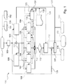
- Fig. 1 shows a device 100 for matching a measured position 101 of an object with information of a digital map 102.
- the information of the map can be given for example by cartography elements and corresponding data.
- a computing unit 103 which can also be designed as a fast-exclusion filter, is provided.
- the digital map 102 the information stored in it, such as the information about positions of different cartography elements, the arithmetic unit 103 is available. This is illustrated by the arrows 130, 131.
- this information may be provided directly to the sub-units 104, 105, 106, 107 and 108, which is exemplified by the arrow 126.
- the computing unit 103 executes one of several possible algorithms, which selects the appropriate cartographic elements based on the measured position 101 and on the basis of a predefined error. After this selection becomes the reduced record the sub-units 104, 105, 106, 107 and 108 are provided.
- the first sub-calculation unit 104 calculates a first value for each selected mapping element by a first method
- the second sub-calculation unit 105 calculates a second value for each selected mapping element by a second method.
- a first filter 109 and a second filter 110 are shown.
- the first filter 109 is set up for determining the system state of the object and, for example in the case of a vehicle, can statistically estimate the position, the speed and the acceleration of the vehicle. An execution of this filter as a Kalman filter is possible. To determine this condition the filter 109 is provided with the GPS position in corrected version 122. After the system state has been determined by the filter 109, the result can be made available to one or more sub-calculation units. In the embodiment shown here, the sub-calculation unit 107 and the sub-calculation unit 104 are supplied with the information about the current system state.
- the second filter 110 which may for example also be designed as a Kalman filter, serves to iteratively eliminate or minimize errors in the GPS position by, for example, an estimation method.
- the filter 110 can thus be supplied with the current measured position of the object 101 after a possible check by means of a check sum 113. But also a feedback of the error value after a successful adjustment by means of feedback loop 121 to the second filter 110 is possible.
- the current measured position 110 is provided by a satellite navigation receiver 111. It can For example, NMEA files are used for communication between navigation devices 112.
- Both filters 109 and 110 can determine the system state or the position error by means of a stochastic state estimation, but it is also possible to provide sensor data, for example of a vehicle to the two filters, or a combination of the use of sensor data and the stochastic estimation. A combination of the two methods can be used to minimize errors based on faulty sensor data.
- each of the selected cartographic elements has been assigned a value per method unit by the methods of the individual slave units 104 to 108, these values of each cartographic element are added to a respective final value 114. These final values correspond to the probability that the object will be at the position of the respective cartographic element located. Then, an order of the cartographic elements may be created according to their likelihood to decide which actual position to use for matching. This corresponds to the target cartography element with its geographical position 115.
- the device 100 is the FIG. 1 in order to output the target cartography element, the new adjusted position and the error of the new adjusted position compared to the originally measured position 118, 119 and 120.
- an error value 117 is obtained by means of the new adjusted position and the provision of the measured position 125 calculated.
- This error may further be provided feedback to the offset eliminating filter 110 in a feedback loop 121 in order to iteratively calculate a position of the object which is as precisely as possible adjusted with renewed steps.
- the first sub-calculation unit 104 may, for example, carry out the method of the road distance module.
- the second sub-calculation unit 105 can, for example, calculate values of the cartographic elements by means of the method of a memory module.
- the third sub-calculation unit 106 can, for example, estimate the relevant cartography elements with regard to their probability by means of the method of the probability of passing or by means of a size module.
- the fourth sub-calculation unit 107 may, for example, execute the method of an angle module.
- the fifth subunit 108 can, for example, carry out the method of a distance module.
- the distance module calculates a score for each cartographic element.
- ⁇ cs corresponds to the angle between the link vector and the individual segment vectors
- v the estimated actual speed
- ⁇ t the estimated time increment between the last sample and the next one.
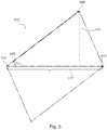
- speed v and time increment ⁇ t must be estimated. This can be realized, for example, with the aid of a Kalman filter. Graphically, these average induced errors in FIG. 3 shown. The average of a linear sequence starting at zero is half the maximum value. The maximum error is sin ⁇ cs. • Base and base are equal to v • ⁇ t .
- the memory module considers that, logically, the last known road or at least one associated road is more likely to be the current road.
- the memory module can be adapted very much to your own needs, and it is possible to change the memory effect of this module by setting parameters accordingly.
- a higher score in a segment corresponds to a higher probability for that segment to be the right one.
- the point system is inverted compared to the points system of the other modules because it can be adjusted by the user and thus corresponds to the description of a probability distribution function. For this reason, the result (the score) of this module corresponds to this - inverted - function.
- the memory indicates that a segment has been previously selected or that it has been directly connected to a segment.
- the path probability / size module ensures that a larger road is rated with a higher probability, firstly because it drives more vehicles and secondly it has a larger surface area.
- the amount of vehicles in a road and therefore the number depends corresponding segments from a number of factors that are difficult to determine. It is assumed that this amount of vehicle is proportional to the size of the road. In this way, it is assumed that the vehicles are evenly distributed on the road.
- This score is converted by the memory module before being compared to the other scores because the other scores are low if they are likely to be segments and high if they are unlikely segments.
- S d is the estimate of the distance traveled on the road, for example calculated with the state of a Kalman filter.
- the Road Distance Module or Road Distance Module is a completely new method of map matching.
- a Kalman filter is used to estimate the current state of motion and the distance covered in the road.
- This module corresponds to a completely independent map matching, which does not require the further sub-calculation units and methods. This task only requires a starting point and a special decision module for cases of doubt. Combining this module with the other modules, this need is already covered by all other modules.
- This module estimates longitudinally and determines the position by longitudinal projection of the distance covered in the current road. This means that the distance traveled is determined and all possible positions in the road corresponding to this distance are searched for. Starting from these positions, it follows all possible road directions and indicates the distance to it.
- This module can also make a decision without GPS information if during this time without connection no other roads intersect, which is normally the case in tunnels. Therefore, this module offers the system the possibility of "dead reckoning" (also called Dead Reckoning). This is another significant advantage of the invention.
- this module weighs two possible positions.
- the two drawn vehicles represent the two possible positions and d n +11 is the estimate of the next distance traveled.
- This module is computationally complex because the minimum distance to each possible street point has to be calculated backwards, because from one point A to another point B different paths can exist and all have to be analyzed.
- the calculation of the estimated traveled distance is now carried out, for example, with a Kalman filter.
- map matching is used on motor vehicles, the accuracy of this module can increase significantly because the vehicle sensors can be used to estimate this distance traveled and not the derived information from the GPS, as in the Kalman filter. Another Kalman filter using vehicle sensors should then be implemented to calculate these traveled distances.
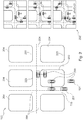
- FIG. 12 shows a digital map 102 showing a measured position of a vehicle 101 that may not match the infrastructure of the map shown.
- the vehicle 200 is situated within a building 203 according to measured positions.
- the device and the method according to the invention can determine the actual position of the vehicle by means of the quick-exclusion filter function and by the combination of various methods for calculating and evaluating the various cartographic elements. The exact determination can also be made iteratively and with a control loop.
- exemplary cartography elements 204, roads and buildings are shown.
- Fig. 2 the new adjusted position 201 after the target mapping element 115 has been selected. This corresponds to the new adjusted position of the vehicle 201. Further shows Fig. 2 a possible calculation of the new adjusted position 202 by means of vectorial representation of segments and distances of the vehicle.
- Fig. 3 shows the induced error in case the sub-unit executes the method of an angle module.
- the value v ⁇ T 305 can be represented as shown.
- An angle between the road vector and the segment vector 300 is indicated.
- the induced error 303 during the next time interval is shown on the right edge of the image as the height of the triangle.
- Fig. 4 shows a graphical representation of the function of the rapid exclusion filter or the arithmetic unit
- the arithmetic unit is designed to a first selection of cartography elements of the map based on the measured position and based on a predefined error.
- the algorithm 400 is shown for fast exclusion of segments of a card.
- a square area 402 with the boundaries 401 is shown.
- the maximum error Dmax 403 which is shown as the radius of a circle, describes the area around the measured position 101, in which the permissible segments may lie.
- segments that have been sorted out correctly 404, as well as segments that have not been sorted out, although they do not satisfy the ideal filter condition of the maximum distance Dmax 405, are shown. Correctly unsorted segments 406 are also shown.
- cartographic element means both nodes, segments, paths and closed paths.
- Fig. 4 2 shows a graphical representation of the mode of operation of an exemplary embodiment of the arithmetic unit or of the fast-exclusion filter with regard to the first selection.
- This is an exemplary algorithm of the arithmetic unit.
- This quick-exclusion filter is needed to balance all modules or sub-calculation units at the same time. It is a relatively complex process to select the segments within a maximum radius. The permissible area of this selection is ideally a circle.
- the computational complexity is even higher when the cartographic elements are segments because the shortest distance to the line formed by the two ends of the segment must be calculated by projecting the center onto that line and then evaluating it, if this projection is inside the segment. If this is not the case, the minimum distance corresponds to the distance to the nearest segment end.
- Another valid approach is to turn the shape of the maximum distance, which is ideally a circle, into a square. This makes a linear comparison of the distances possible.
- a second filter can be used for the filtered elements. This means that only the filtered elements (elements within the square) are filtered again with a holistic filter (only the elements in the circle are selected). With a square area it is possible to set four different boundaries: H + , H - , V + and V - .
- This exemplary filter method for fast exclusion of cartography elements is in FIG. 4 graphically illustrated.
- Fig. 5 shows an equivalent parallelogram 500 for calculation by the distance module. This calculation, for example, in the sub-calculation units 104 to 108 of the Fig. 1 be executed. It is the height 501, the base 502, the angle 503, P1 504, P2 505 and C designated 506.
- Fig. 6 is a schematic representation of a digital map 102 in which the calculation is represented by a road distance module 600.
- Fig. 7 is a schematic representation of a flowchart illustrating a method according to an embodiment of the invention.
- a computing unit is provided.
- step S2 a selection of cartographic elements of the map based on the measured position and on the basis of a predefined error by the arithmetic unit is executed.
- step S3 represents a provision of the selected cartographic elements to a first and a second sub-calculation unit by the arithmetic unit.
Description
Die Erfindung betrifft die Berechnung von Positionsdaten eines Objektes. Insbesondere betrifft die Erfindung eine Vorrichtung zum Abgleich einer gemessenen Position eines Objektes mit Information einer digitalen Karte, ein System, die Verwendung einer Vorrichtung, ein Fahrzeug, ein Verfahren, ein Programmelement sowie ein computerlesbares Medium.The invention relates to the calculation of position data of an object. In particular, the invention relates to a device for matching a measured position of an object with information of a digital map, a system, the use of a device, a vehicle, a method, a program element and a computer-readable medium.
Sicherheitsrelevante Fahrzeugassistenzsysteme müssen in der Lage sein, gefährliche Situationen vorauszusagen, die zu einem Verlust über die Fahrzeugkontrolle oder zu einer Kollision führen können. Wird eine solche Situation rechtzeitig vorausgesagt, so kann diese u.U. vermieden werden, und zwar autonom z.B. durch Abbremsen des Fahrzeugs, oder durch Warnung des Fahrers über diese bevorstehende Situation mittel eines Warnsystems.Safety-related vehicle assistance systems must be able to predict dangerous situations that may result in vehicle control loss or collision. If such a situation is predicted in good time, then this may u.U. be avoided, autonomously e.g. by decelerating the vehicle, or warning the driver of this imminent situation by means of a warning system.
Bisher wurde diese Vorhersagemöglichkeit durch verschiedene Arten von Sensoren, Radarsystemen oder Kameras erreicht, die jedoch alle auf das direkte Sichtfeld des Fahrzeugs beschränkt sind. Das bedeutet, dass sie keine weiteren Informationen darüber liefern können, was beispielsweise nach einer Kurve geschieht.So far, this predictive capability has been achieved by various types of sensors, radar systems or cameras, but all are limited to the direct field of view of the vehicle. This means that they can not provide any further information about what happens after a curve, for example.
Mit Hilfe von Kartendaten ist es möglich, diese Voraussagen zu verbessern und z.B. vorhersagen zu können, wie die Straße nach der nächsten Kurve verläuft.
Um die Informationen einer Karte zu verwenden, muss die aktuelle Position bekannt sein. Diese aktuelle Position kann mit verschiedenen Mitteln erkannt werden, z.B. mit einem GPS-Empfänger, der eine preisgünstige und globale Lösung sein kann. Das GPS oder ein anderes Positioniersystem weist einen Fehler auf, der es nicht immer möglich macht, eine Position genau in einer Straße anzugeben. Außerdem kann eine Karte auch immer einige Genauigkeitsfehler und Abweichungen zu der wirklichen Kartographie aufweisen, wodurch die Positionsermittlung direkt in einer Straße erschwert oder gar unmöglich ist.With the help of map data, it is possible to improve these predictions and to be able to predict, for example, how the road will go to the next bend.
To use the information of a map, the current position must be known. This current position can be detected by a variety of means, such as a GPS receiver, which can be a low-cost, global solution. The GPS or other positioning system has an error that does not always make it possible to specify a position exactly in a road. In addition, a map can always have some accuracy errors and deviations from the actual cartography, making it difficult to determine the position directly in a road or even impossible.
In diesem Zusammenhang offenbart die
Die
Aus der
Es ist eine Aufgabe der Erfindung, einen verbesserten Abgleich einer gemessenen Position eines Objektes mit Information einer digitalen Karte bereitzustellen.It is an object of the invention to provide an improved alignment of a measured position of an object with information of a digital map.
Es sind eine Vorrichtung zum Abgleich einer gemessenen Position eines Objektes mit Information einer digitalen Karte, ein System, eine Verwendung einer Vorrichtung, ein Fahrzeug, ein Verfahren, ein Programmelement, sowie ein computerlesbares Medium gemäß den Merkmalen der unabhängigen Ansprüche angegeben. Weiterbildungen der Erfindung ergeben sich aus den abhängigen Ansprüchen. Die beschriebenen Ausführungsbeispiele betreffen gleichermaßen die Vorrichtung, das System, die Verwendung, das Fahrzeug, das Verfahren, das Programmelement und das computerlesbare Medium.A device for matching a measured position of an object with information of a digital map, a system, a use of a device, a vehicle, a method, a program element, and a computer-readable medium are given according to the features of the independent claims. Further developments of the invention will become apparent from the dependent claims. The described embodiments equally relate to the device, the system, the use, the vehicle, the method, the program element and the computer-readable medium.
Gemäß einem Ausführungsbeispiel der Erfindung ist eine Vorrichtung zum Abgleich einer gemessenen Position eines Objektes (beispielsweise eines Fahrzeuges) mit Information einer digitalen Karte angegeben, wobei die Vorrichtung eine Recheneinheit aufweist. Dabei ist die Recheneinheit zu einer ersten Auswahl von Kartographieelementen der Karte auf Basis der gemessenen Position und auf Basis eines vordefinierten Fehlers ausgeführt. Weiterhin ist die Recheneinheit zur Bereitstellung der ausgewählten Kartographieelemente an eine erste und eine zweite Untereinheit ausgeführt.According to one exemplary embodiment of the invention, a device for matching a measured position of an object (for example a vehicle) with information of a digital map is specified, the device having a Computing unit has. In this case, the arithmetic unit is designed for a first selection of cartographic elements of the card on the basis of the measured position and on the basis of a predefined error. Furthermore, the arithmetic unit is designed to provide the selected cartographic elements to a first and a second subunit.
Weiterhin kann die erste Auswahl zusätzlich oder ersetzend auch auf Basis von Koordinaten der Kartographieelemente durch die Recheneinheit erfolgen.Furthermore, the first selection can additionally or substitution also be carried out on the basis of coordinates of the cartographic elements by the arithmetic unit.
Dabei sei weiterhin angemerkt, dass im Kontext der Erfindung der Begriff "Abgleich" gleichzusetzen ist mit dem Begriff des "map matching" und umgekehrt.It should also be noted that in the context of the invention the term "matching" is to be equated with the term "map matching" and vice versa.
Dabei ist im Folgenden unter dem Begriff "Kartographieelement" jedes Element einer Karte zu verstehen, das mit Hilfe der vier Grundelemente Knoten, Segment, Weg oder geschlossener Weg dargestellt werden kann. Dabei ist ein Knoten ein Punkt im Raum, der beispielsweise GPS-Koordinaten wie Breite und Höhe aufweist. Ein Segment ist eine Linie, die zwei Knoten miteinander verbindet und ein Weg ist ein Satz gruppierter Segmente.In the following, the term "cartographic element" is to be understood as meaning every element of a map which can be represented by means of the four basic elements node, segment, path or closed path. A node is a point in space that has GPS coordinates such as latitude and longitude. A segment is a line connecting two nodes, and a path is a set of grouped segments.
Mit anderen Worten wird durch dieses Ausführungsbeispiel der Erfindung ein Schnellausschlussfilter angegeben, der diejenigen Kartographieelemente mit ihrer gegebenen Position auswählt, die ein vordefiniertes Fehlerkriterium erfüllen. Dieses Kriterium kann beispielsweise rechnerisch durch einen maximalen Abstand gegeben sein, der graphisch durch einen Kreis mit Radius des maximalen Abstandes um die gemessene Position dargestellt wird. Dabei kann beispielsweise berechnet werden, ob sich die Segmente nach verschiedenen Formeln innerhalb des maximalen Fehlers befinden. Diese Filtermethode zum schnellen Ausschluss von Kartographieelementen wird beispielsweise auch in
Durch diese Selektion derjenigen Kartographieelemente, die für einen nachfolgenden map matching Prozess relevant sind, kann schneller und mit weniger Rechenleistung ein map matching erfolgen. Ziel eines darauf folgenden map matching Verfahrens ist es, anhand der Positionsbestimmung eines beispielsweise GPS, welches einen spezifischen Fehler aufweist, zwischen möglichen Punkten einer Karte zu entscheiden, auf welchen Punkt sich die Positionsbestimmung bezieht. In bestimmten Fällen muss beispielsweise nach Empfang einer GPS-Position entschieden werden, in welcher Straße sich der GPS-Empfänger befindet. Dabei muss zunächst analysiert werden, warum ein Abgleich oder ein map matching und vor allem mit welcher Methode bzw. mit welchem map matching Verfahren dies geschehen muss. Daraufhin wird die beste Methode extrahiert und die Recheneinheiten werden daraufhin bewertet. Zum Beispiel kann im Falle eines Fahrzeuges die gemessene Position, die auf Grund verschiedenster Fehlerquellen nicht exakt sein kann mit Kartendaten angepasst werden. Dabei können die Kartendaten ebenso fehlerbehaftet sein. Daher können beispielsweise die zwei nächst gelegenen Straßen aus einer Karten mit vielen Straßen, die jedoch entfernter liegen ausgewählt werden. Dabei sind in diesem Falle Straßen als ein Segment bzw. Kartographieelement anzusehen. Eine Anschließende Berechnung der Wahrscheinlichkeit auf Basis des Fahrzeugzustandes, in welcher der beiden Straßen sich das Fahrzeug tatsächlich befindet kann mittels verschiedener Methoden parallel berechnet und verglichen werden.By selecting those cartographic elements that are relevant for a subsequent map matching process, map matching can be done faster and with less computational power. The aim of a subsequent map matching method is to decide based on the position of a GPS, for example, which has a specific error, between possible points of a map, to which point the position determination refers. In certain cases, for example, after receiving a GPS position, it must be decided in which road the GPS receiver is located. First of all, it has to be analyzed, why a comparison or a map matching and especially with which method or with which map matching procedure has to be done. Then the best method is extracted and the arithmetic units are then evaluated. For example, in the case of a vehicle, the measured position, which can not be exact due to various sources of error, can be matched with map data. The map data can also be faulty. Therefore, for example, the two nearest roads may be selected from a map with many roads, but more distant. In this case, roads are to be regarded as a segment or cartographic element. A subsequent calculation of the probability on the basis of the vehicle condition, in which of the two roads the vehicle is actually located, can be calculated and compared in parallel by means of various methods.
Dabei sei weiterhin angemerkt, dass die Vorrichtung und die Recheneinheit mit mathematischen Verfahren oder Algorithmen arbeiten kann, welche beispielsweise auf einer CPU ausgeführt werden können. Aufgrund dieser ersten Auswahl von Kartographieelementen erfolgt somit eine Reduktion und Eliminierung unnötiger Kartographieelemente bzw. Segmente aus der digitalen Karte, wodurch beispielsweise anschließend ein vereinfachter Abgleich stattfinden kann.It should also be noted that the device and the arithmetic unit can work with mathematical methods or algorithms which can be executed, for example, on a CPU. As a result of this first selection of cartographic elements, a reduction and elimination of unnecessary cartographic elements or segments from the digital map takes place, as a result of which, for example, a simplified adjustment can then take place.
Ebenso sei darauf hingewiesen, dass die Recheneinheit weiterhin derart ausgeführt sein kann, dass sie die ausgewählten Kartographieelemente beliebig vielen weiteren Unterrecheneinheiten zur Verfügung stellt. Die Verwendung nur einer Unterrecheneinheit ist natürlich auch möglich.It should likewise be pointed out that the arithmetic unit can furthermore be designed in such a way that it makes the selected cartographic elements available to any number of further sub-computation units. The use of only one Unterrecheneinheit is of course also possible.
Dabei kann der vordefinierte Fehler beispielsweise ein Fehlerwert sein, der auf einer Fehlerverteilung eines GPS-Systems basiert. Die Fehlerverteilung eines GPS-Systems entspricht einer Normalverteilung, aus welcher ein vordefinierter Fehler abgeleitet werden kann. Dieser Fehlerwert kann aber auch iterativ nach einzelnen Abgleichen angepasst und optimiert werden.For example, the predefined error may be an error value based on an error distribution of a GPS system. The error distribution of a GPS system corresponds to a normal distribution, from which a predefined error can be derived. This error value can also be adapted and optimized iteratively after individual adjustments.
Mit anderen Worten eliminiert die Vorrichtung durch die erste Auswahl die Anzahl der Daten zu den Kartographieelementen derart, dass sich eine anschließende Verbesserung oder Überprüfung der gemessenen Position nur auf eine kleine Karte konzentriert und nur noch die relevanten Segmente mit ihren Positionen berechnen und bewerten muss. Mit anderen Worten wird die Information der Karte für eine komplexe Nachbearbeitung vorgefiltert. Dies kann eine wesentlich Einsparung von Zeit und Rechenleistung bedeuten.In other words, by the first selection, the device eliminates the number of data to the cartographic elements such that subsequent improvement or verification of the measured position focuses only on a small map and only has to calculate and evaluate the relevant segments with their positions. In other words, the information of the card is pre-filtered for complex post-processing. This can mean a significant saving in time and computing power.
Dabei kann weiterhin vorgesehen sein, dass der Wert des vordefinierten Fehlers adaptiv an die Situation angepasst wird. Das heißt die Vorrichtung vergrößert den maximalen Fehlerkreis, wenn innerhalb des abgedeckten Bereichs überhaupt kein map matching durchgeführt werden kann. Ist das map matching möglich, verkleinert das System den maximalen Fehlerkreis bis zu dem theoretisch vordefinierten Wert.It can further be provided that the value of the predefined error is adapted adaptively to the situation. That is, the device increases the maximum error circle if no map matching can be performed at all within the covered area. If the map matching is possible, the system reduces the maximum error circle up to the theoretically predefined value.
Dabei kann die Auswahl der relevanten Kartographieelemente durch die Vorrichtung dazu benutzt werden, um anschließend eine gleichzeitige Abwägung und Bewertung der verschiedenen Kartographieelemente durch verschiedene Module oder durch verschiedene Unterrecheneinheiten durchzuführen. Dabei könne diese Unterrecheinheiten als unabhängige map matching Algorithmen angesehen werden, die gleichzeitig, parallel und unabhängig voneinander arbeiten können. Ohne die erste Auswahl durch die Vorrichtung wäre ein Abgleich einer gemessenen Position eines Objektes mit Informationen der digitalen Karte weitaus komplexer und könnte nur schwer in Echtzeit ausgeführt werden.In this case, the selection of the relevant cartographic elements by the device can be used to subsequently carry out a simultaneous weighing and evaluation of the various cartographic elements by different modules or by different sub-calculation units. It could this Sub-units are considered as independent map-matching algorithms that can operate simultaneously, in parallel, and independently of each other. Without the first selection by the device, matching a measured position of an object with digital map information would be far more complex and difficult to perform in real time.
Dabei kann die gemessene Position auch ein nicht aktueller Datensatz sein und auch eine zumindest Teilberechnung der gemessenen Position aus einem älteren Positionsdatensatz ist möglich. Eine Navigationsfähigkeit ist somit kein wesentlicher Bestandteil dieses Ausführungsbeispiels. Weiterhin kann nach einem Abgleich die neue Position als Feedback Information erneut der Vorrichtung und/oder der Recheneinheit zugeführt werden. Dies entspricht einer Feedbackschleife zum optimierten map matching.In this case, the measured position may also be a non-current data record and also an at least partial calculation of the measured position from an older position data record is possible. A navigation capability is thus not an essential part of this embodiment. Furthermore, after a comparison, the new position can be fed again as feedback information to the device and / or the arithmetic unit. This corresponds to a feedback loop for optimized map matching.
Dazu kann beispielsweise eine Positionsbestimmungseinheit wie eine GPS-Einheit in dem Objekt verwendet werden. Dabei ist darauf hinzuweisen, dass im Kontext der vorliegenden Erfindung GPS stellvertretend für sämtliche globale Navigationssatellitensysteme (GNSS) steht, wie zum Beispiel GPS, Galileo, GLONASS (Russland), KOMPASS (China), IRNSS (Indien), ...For this purpose, for example, a position determination unit such as a GPS unit can be used in the object. It should be noted that in the context of the present invention GPS is representative of all global navigation satellite systems (GNSS), such as GPS, Galileo, GLONASS (Russia), COMPASS (China), IRNSS (India), ...
Unter dem Begriff "digitale Karten" sind auch Karten für fortschrittliche Fahrerassistenzsysteme (Advanced Driver Assistant System, ADAS) zu verstehen, ohne dass eine Navigation stattfindet. Dabei kann das verwendete digitale Kartenformat nach Kriterien und Parametern ausgesucht und möglicherweise verändert werden, um dieses und jedes andere Ausführungsbeispiel der Erfindung zu ermöglichen. Eine Anpassung des Formats an die verwendeten Algorithmen ist möglich. Beispielsweise kann ein Format verwendet oder erzeugt werden, dass die erfindungsgemäße Auswahl von Kartographieelementen und die parallele Berechung von Werten einzelner Unterrecheneinheiten verbessert wird.The term "digital maps" is also understood to mean maps for advanced driver assistance systems (ADAS) without navigation. In this case, the digital map format used can be selected according to criteria and parameters and possibly changed in order to enable this and any other embodiment of the invention. An adaptation of the format to the algorithms used is possible. For example, a format can be used or generated to improve the selection of cartographic elements according to the invention and the parallel calculation of values of individual sub-calculation units.
Dabei können die Unterrecheneinheiten auch physikalisch in der Recheneinheit enthalten sein.In this case, the sub-calculation units can also be physically contained in the arithmetic unit.
Gemäß einem weiteren Ausführungsbeispiel der Erfindung weist die Vorrichtung weiterhin die erste und die zweite Unterrecheneinheit auf, wobei die erste Unterrecheneinheit zur Berechnung eines ersten Wertes für jedes ausgewählte Kartographieelement mittels eines ersten Verfahrens bzw. einer ersten Methode ausgeführt ist. Weiterhin ist die zweite Unterrecheneinheit zur Berechnung eines zweiten Wertes für jedes ausgewählte Kartographieelement mittels eines zweiten Verfahrens bzw. einer zweiten Methode ausgeführt, wobei die ersten und die zweiten Werte in der gleichen Maßeinheit berechnet sind bzw. auf die gleiche Maßeinheit umgerechnet werden.According to a further embodiment of the invention, the apparatus further comprises the first and the second sub-calculation unit, wherein the first sub-calculation unit is designed to calculate a first value for each selected mapping element by means of a first method or a first method. Furthermore, the second sub-calculation unit is designed to calculate a second value for each selected cartography element by means of a second method or a second method, wherein the first and the second values are calculated in the same unit of measure or are converted to the same unit of measure.
Mit anderen Worten sind die Unterrecheneinheiten und die verwendeten Methoden derart ausgeführt, dass eine Umrechnung von jeweils spezifischen physikalischen Einheiten der Unterrecheneinheit auf eine vorgegebene Basiseinheit, die gleiche Maßeinheit erfolgt. Sollten Algorithmen zur Berechnung der Werte verwendet werden, so ist eine Auswahl der Algorithmen derart nötig, dass stets die vordefinierte Maßeinheit für jede verwendete Unterrecheneinheit erfolgt. Dabei kann die Wahl der gleichen Maßeinheit durch die Vorrichtung, durch die Recheneinheit, also den Schnellausschlussfilter, oder auch durch einen Benutzer vorgegeben werden.
Die Berechnung der Werte in den verschiedenen Unterrecheneinheiten in einer gemeinsamen Einheit ermöglicht den nachfolgenden Direktvergleich von Werten der einzelnen Kartographieelemente. Dies ermöglicht eine Kombination verschiedener Berechnungsmethoden und liefert somit mehr Information zur Entscheidung über einen Abgleich. Dies minimiert einen möglichen Fehler des Abgleichs.In other words, the sub-calculation units and the methods used are designed in such a way that a conversion of respectively specific physical units of the sub-calculation unit to a predefined basic unit, the same unit of measure, takes place. If algorithms are used to calculate the values, a selection of the algorithms is necessary in such a way that always the predefined unit of measurement is used for each used sub-calculation unit. In this case, the choice of the same unit of measurement can be specified by the device, by the arithmetic unit, that is to say the rapid exclusion filter, or also by a user.
The calculation of the values in the various sub-calculation units in a common unit enables the subsequent direct comparison of values of the individual cartographic elements. This allows a combination of different calculation methods and thus provides more information for deciding on a comparison. This minimizes a possible mismatch error.
Mit anderen Worten werden beispielsweise für zwei Straßen mit ihren Entfernungen zur gemessenen Position und mit ihren Ausrichtungen im Vergleich zum aktuellen Positions- und Bewegungszustandes des Objektes durch ein Entfernungsmodul und ein Winkelmodul Werte berechnet, welchen eine Wahrscheinlichkeit zugeordnet werden kann. Dieser Wert gibt an, mit welcher Wahrscheinlichkeit es sich bei der realen Position des Fahrzeuges um die Position des jeweiligen Kartographieelements handelt. Durch eine zusätzliche Bewertung oder ein Tuning mittels eines Tuning Parameters kann ebenso die Gewichtung einer Unterrecheneinheit und der darin berechneten Werte erfolgen.In other words, for example, for two roads with their distances to the measured position and with their orientations compared to the current position and movement state of the object by a distance module and an angle module values are calculated to which a probability can be assigned. This value indicates with which probability the actual position of the vehicle is the position of the respective cartography element. An additional evaluation or tuning by means of a tuning parameter can also be used to weight a sub-calculation unit and the values calculated therein.
Der map matching Algorithmus wendet somit verschiedene Analysemethoden auf die ausgewählten Kartographieelemente an und wertet dann die Ergebnisse aller Methoden aus. Um die Werte der unterschiedlichen Methoden vergleichen zu können, müssen die normalerweise unterschiedlichen Einheiten umgerechnet oder transformiert werden.The map matching algorithm thus applies different analysis methods to the selected cartographic elements and then evaluates the results of all methods. In order to be able to compare the values of the different methods, the normally different units have to be converted or transformed.
Mit anderen Worten: Unterschiedliche Faktoren bewerten unterschiedliche Eingabeparameter, weshalb deren Ergebnis in unterschiedlichen Einheiten ausgedrückt werden kann. Beispielsweise gibt ein Entfernungsmodul, was als erste Unterrecheneinheit angesehen werden kann, einen Abstand an, wohingegen ein Winkelmodul, was als zweite Recheneinheit angesehen werden kann, einen Winkel angibt. Da Winkel mit Abständen nicht vergleichbar sind, gibt die erfindungsgemäße Vorrichtung eine Möglichkeit an, Maßeinheiten zu definieren und eine Umwandlung für die einzelnen Einheiten der einzelnen Unterrecheneinheiten bereitzustellen.In other words, different factors evaluate different input parameters, so their result can be expressed in different units. For example, a distance module, which may be regarded as a first inter-unit, indicates a distance, whereas an angle module, which can be regarded as a second processor, indicates an angle. Since angles are not comparable with distances, the device according to the invention indicates a possibility of defining units of measurement and of providing a conversion for the individual units of the individual sub-calculation units.
Gemäß einem weiteren Ausführungsbeispiel der Erfindung ist die Vorrichtung weiterhin zur Addition des ersten und des zweiten Wertes jedes ausgewählten Kartographieelements zu einem jeweiligen Endwert ausgeführt.According to another embodiment of the invention, the apparatus is further adapted to add the first and second values of each selected cartographic element to a respective final value.
Dabei ist natürlich nicht ausgeschlossen, dass die Ausführbarkeit der Addition auch im Falle von weiteren Unterrecheneinheiten die weitere Werte zur Verfügung stellen, gegeben ist.Of course, it is not excluded that the feasibility of the addition in the case of further sub-calculation units provide the other values, is given.
Auf diese Art und Weise sammeln die Kartographieelemente bestimmte Punktzahlen von den einzelnen Unterrecheneinheiten oder Modulen. Dabei entsprechen den Punktzahlen jeweils Wahrscheinlichkeiten der Kartographieelemente, die tatsächliche Position des Objekts aufzuweisen. Wobei nach einer Addition der einzelnen Werte eines Kartographieelements zu einem Endwert eine Reihenfolge auf Basis dieser Wahrscheinlichkeiten der Kartographieelemente erstellt wird. Diese Reihenfolge wird für den Abgleich bzw. das map matching herangezogen.In this way, the cartographic elements collect certain scores from the individual sub-units or modules. In each case, the probabilities of the cartographic elements correspond to the scores, to show the actual position of the object. Wherein, after adding the individual values of a cartographic element to a final value, an order based on these probabilities of the cartographic elements is created. This sequence is used for matching or map matching.
Gemäß einem weiteren Ausführungsbeispiel der Erfindung ist die Vorrichtung weiterhin zu einer Bewertung der ersten Unterrecheneinheit und einer Bewertung der zweiten Unterrecheneinheit ausgeführt, was zu einer entsprechenden Gewichtung der beiden Werte jedes ausgewählten Kartographieelements führt.According to a further embodiment of the invention, the device is further configured to evaluate the first sub-calculation unit and an evaluation of the second sub-calculation unit, resulting in a corresponding weighting of the two values of each selected mapping element.
Dabei kann die Bewertung der Unterrecheneinheiten durch die Recheneinheit gesteuert sein und erfolgen, aber auch eine Bewertung durch den Benutzer der Vorrichtung oder auch eine automatische Bewertung auf Basis von zur Verfügung gestellten Messdaten ist möglich.In this case, the evaluation of the sub-calculation units can be controlled and carried out by the arithmetic unit, but also an evaluation by the user of the device or an automatic evaluation on the basis of provided measurement data is possible.
Dabei können alle Unterrecheneinheiten bzw. Module als eigenständige map matching Algorithmen angesehen werden. Durch die Bewertung bzw. durch Modifizierung eines Tuning-Parameters ist es möglich, nur ein Modul für das Map matching zu verwenden und dieses trotzdem auszuführen. Hierzu können beispielsweise die Einflüsse der anderen Unterrecheneinheiten über die Tuning-Parameter bzw. die Gewichtung auf Null gesetzt werden. So ist diese Vorrichtung in der Lage, ein map matching als Kombination aus verschiedenen Unterrecheneinheiten oder verschiedenen map matching Algorithmen zur Verfügung zu stellen. Sollte eine bestimmte Kartensituation vorliegen, kann diejenige Kombination der Unterrecheneinheiten mit entsprechender Bewertung erfolgen, bei der die Entscheidungsmethode optimal ist.All sub-calculation units or modules can be regarded as independent map-matching algorithms. By evaluating or modifying a tuning parameter, it is possible to use only one module for map matching and to execute it anyway. For this purpose, for example, the influences of the other sub-calculation units can be set to zero via the tuning parameters or the weighting. So this device is capable of a map matching as a combination of different To provide sub-calculation units or various map matching algorithms. If there is a specific card situation, the combination of the sub-calculation units can be made with appropriate evaluation, in which the decision-making method is optimal.
Gemäß einem weiteren Ausführungsbeispiel der Erfindung ist die Vorrichtung weiterhin zu einer zweiten Auswahl eines Zielkartographieelements aus den ausgewählten Kartographieelementen auf Basis der Endwerte ausgeführt. Weiterhin ist die Vorrichtung derart ausgeführt, dass der Abgleich auf Basis des Zielkartographieelements erfolgt.According to another embodiment of the invention, the apparatus is further adapted to a second selection of a target mapping element from the selected mapping elements based on the end values. Furthermore, the device is designed such that the adjustment takes place on the basis of the target cartography element.
Mit anderen Worten kann somit nach einer Berechnung aller relevanten und vorher bereits ausgewählten Kartographieelemente in den verschiedenen Unterrecheneinheiten die Auswahl des Zielkartographieelements stattfinden. Das Zielkartographieelement ist dabei dasjenige Kartographieelement, welches aufgrund der erstellten Reihenfolge und eventuell erfolgter Bewertung am wahrscheinlichsten ist.In other words, after a calculation of all relevant and previously selected cartographic elements in the various sub-calculation units, the selection of the target mapping element can take place. The target cartography element is the one cartographic element that is the most likely due to the created order and possibly the evaluation.
Daraufhin kann die gemessene Position des Objektes durch die Position des Zielkartographieelements ersetzt werden. Somit ist die Position des Zielkartographieelements die neue angepasste Position des Objekts.Thereupon, the measured position of the object can be replaced by the position of the target cartographic element. Thus, the position of the target cartography element is the new adjusted position of the object.
Sollte beispielsweise die gemessene GPS-Position eines Fahrzeuges als GPS-Daten angegeben werden, die in Realität einem Fluss entsprechen, so kann durch einen anschließenden Abgleich diejenige Position beispielsweise einer nächstliegenden Straße als Zielkartographieelement herausgefunden werden. Dabei ist das Zielkartographieelement dasjenige Kartographieelement, das zuerst in einer Auswahl die Bedingungen eines Fehlerkriteriums erfüllt hat und in einem zweiten berechnenden Algorithmusschritt die höchste Wahrscheinlichkeit aufweist.If, for example, the measured GPS position of a vehicle is given as GPS data which correspond in reality to a flow, the position of, for example, a nearest road as the target mapping element can be found out by a subsequent adjustment. In this case, the target cartography element is that cartographic element which has first fulfilled the conditions of an error criterion in a selection and has the highest probability in a second calculating algorithm step.
Gemäß einem weiteren Ausführungsbeispiel der Erfindung weist die Vorrichtung einen ersten Filter auf, wobei der erste Filter zur Ermittlung eines Zustandes des Objektes ausgeführt ist.According to a further embodiment of the invention, the device has a first filter, wherein the first filter is designed to determine a state of the object.
Der erste Filter, der auch als Modul bezeichnet werden kann, schätzt den Systemzustand bei der Fahrt eines Objektes ein, indem er beispielsweise ein Kalman-Filter auf die gemessene Position des Objektes anwendet. Dabei geht man im Falle eines Fahrzeuges davon aus, dass das Objekt Bewegungen nach den Newtonschen Prinzipien ausführt. Um den Systemzustand komplett einzuschätzen, müssen daher die linear zurückgelegte Distanz, die Geschwindigkeit und die Beschleunigung bewertet werden.The first filter, which may also be referred to as a module, estimates the system state when an object is traveling, for example by applying a Kalman filter to the measured position of the object. In the case of a vehicle, it is assumed that the object performs movements according to Newtonian principles. In order to fully assess the system state, therefore, the linear distance covered, the speed and the acceleration must be evaluated.
Dabei kann der Filter alle bisherigen Werte nehmen, um den nächstfolgenden Wert vorauszusagen. Dies erfolgt jedoch rekursiv durch selbstständige Korrektur eines internen Modells, das die Realität beschreiben sollte. Dabei betrachtet der Filter ein multidimensionales System, in dem die zeitliche Entwicklung eines Prozesses beschrieben werden kann.The filter can take all previous values to predict the next value. However, this is done recursively by self-correcting an internal model that should describe the reality. The filter considers a multidimensional system in which the temporal development of a process can be described.
Gemäß einem weiteren Ausführungsbeispiel der Erfindung weist die Vorrichtung weiterhin einen zweiten Filter auf, wobei der zweite Filter zur Ermittlung eines Fehlers der gemessenen Position ausgeführt ist.According to a further embodiment of the invention, the device further comprises a second filter, wherein the second filter is designed to detect a fault of the measured position.
Dieser Filter, der wie der erste Filter beispielsweise der Auswahl von Kartographieelementen zeitlich vorgeschaltet sein kann, bewertet die Abweichung der gemessenen Position mit Hilfe der beim map matching begangenen Fehler. Dabei kann dieses Modul beispielsweise die GPS-Abweichung mit Hilfe eines Kalman-Filters bewerten. Der Prozesszustand des Kalman-Filters entspricht dabei der Abweichung in Länge und Breite. Mit den bekannten Gleichungen des Kalman-Filters erhält man bei jeder GPS-Positionsschätzung eine neue Bewertung der GPS-Abweichung für die Breite und die Länge.This filter, which, like the first filter, can for example be preceded in time by the selection of cartographic elements, evaluates the deviation of the measured position with the help of the errors committed during map matching. This module can evaluate, for example, the GPS deviation using a Kalman filter. The process state of the Kalman filter corresponds to the deviation in length and width. With the well-known equations of the Kalman filter For each GPS position estimate, a new GPS deviation rating for latitude and longitude is obtained.
Gemäß einem weiteren Ausführungsbeispiel der Erfindung weist zumindest einer der Filter die Eigenschaften eines Kalman-Filters auf.According to a further embodiment of the invention, at least one of the filters has the properties of a Kalman filter.
Gemäß einem weiteren Ausführungsbeispiel der Erfindung ist ein System zum Abgleich einer gemessenen Position eines Objektes mit Information einer digitalen Karte für ein Fahrzeug angegeben, wobei das System eine Vorrichtung gemäß einem der vorherigen Ausführungsbeispiele und einem Satellitennavigationsempfänger aufweist.According to a further embodiment of the invention, a system for matching a measured position of an object with information of a digital map for a vehicle is provided, the system comprising a device according to one of the previous embodiments and a satellite navigation receiver.
Dieses System kann beispielsweise in Fahrzeugen zur genaueren und vorhersagenden Positionsbestimmung oder Positionskorrekturbestimmung verwendet werden. Dies kann erhebliche Vorteile für die Absetzung eines automatischen Notrufs (ECall) sowie eines automatisierten technischen Servicerufs (BCall) verwendet werden, aber auch für Fahrerassistenzsysteme (Advanced Driver Assistance System, ADAS).This system can be used, for example, in vehicles for more accurate and predictive positioning or position correction determination. This can provide significant benefits for setting down an automatic emergency call (ECall) as well as an automated technical service call (BCall), but also for advanced driver assistance systems (ADAS).
Gemäß einem weiteren Ausführungsbeispiel der Erfindung ist die Verwendung einer Vorrichtung nach einem der vorhergehenden Ausführungsbeispiele in einem Fahrzeug angegeben.According to a further embodiment of the invention, the use of a device according to one of the preceding embodiments is indicated in a vehicle.
Gemäß einem weiteren Ausführungsbeispiel der Erfindung ist ein Fahrzeug mit einer Vorrichtung nach einem der vorherigen Ausführungsbeispiele angegeben.According to a further embodiment of the invention, a vehicle is provided with a device according to one of the previous embodiments.
Bei dem Fahrzeug handelt es sich beispielsweise um ein Kraftfahrzeug, wie Auto, Bus oder Lastkraftwagen oder aber auch um ein Schienenfahrzeug, ein Schiff, ein Luftfahrzeug, sowie Helikopter oder Flugzeug oder beispielsweise um ein Fahrrad. Dabei gilt dieses und jedes weitere Ausführungsbeispiel der Erfindung sowohl für einen automatisierten Notruf (ECall) sowie auch für einen automatisierten technischen Serviceruf (breakdown-call, BCall) oder für Fahrerassistenzsysteme (Advanced Driver Assistance System, ADAS).The vehicle is, for example, a motor vehicle, such as a car, bus or truck or even a rail vehicle, a ship, an aircraft, as well as a helicopter or airplane or, for example, a bicycle. In this case, this and every other exemplary embodiment of the invention applies both to an automated emergency call (ECall) and also to an automated technical service call (breakdown-call, BCall) or for driver assistance systems (Advanced Driver Assistance System, ADAS).
Gemäß einem weiteren Ausführungsbeispiel der Erfindung ist ein Verfahren zum Abgleich einer gemessenen Position eines Objektes mit Information einer digitalen Karte angegeben, wobei das Verfahren die folgenden Schritte aufweist: Bereitstellung einer Recheneinheit, Durchführung einer Auswahl von Kartographieelementen der Karte auf Basis der gemessenen Position und auf Basis eines vordefinierten Fehlers durch die Recheneinheit sowie die Bereitstellung der ausgewählten Kartographieelemente an eine und eine zweite Unterrecheneinheit durch die Recheneinheit.According to a further embodiment of the invention, a method for matching a measured position of an object with information of a digital map is provided, the method comprising the following steps: providing a computing unit, performing a selection of map elements of the map based on the measured position and on basis a predefined error by the arithmetic unit and the provision of the selected cartographic elements to one and a second sub-unit by the arithmetic unit.
Gemäß einem weiteren Ausführungsbeispiel der Erfindung ist ein Programmelement angegeben, das, wenn es auf einem Prozessor ausgeführt wird, den Prozessor anleitet, die oben angegebenen Schritte durchzuführen.In accordance with another embodiment of the invention, there is provided a program element which, when executed on a processor, directs the processor to perform the above steps.
Gemäß einem weiteren Ausführungsbeispiel der Erfindung ist ein Medium angegeben, wobei das Medium das Programmelement für ein Download bereitstellt. Dabei ist das Programmelement weiterhin geeignet, wenn es auf einem Prozessor ausgeführt wird, den Prozessor anleitet, die oben angegebenen Schritte durchzuführen.According to another embodiment of the invention, a medium is indicated, wherein the medium provides the program element for download. In this case, the program element is furthermore suitable, if it is executed on a processor, which instructs the processor to carry out the steps specified above.
Ebenso ist es möglich, dass ein bestehendes Programmelement mittels eines Downloads in den Zustand versetzt wird, dass, wenn es auf einem Prozessor ausgeführt wird, den Prozessor anleitet, die oben angegebenen Schritte durchzuführen.Likewise, it is possible for an existing program item to be put into a state by means of a download that, when executed on a processor, instructs the processor to perform the above-mentioned steps.
Gemäß einem weiteren Ausführungsbeispiel der Erfindung ist ein computerlesbares Medium angegeben, wobei auf dem computerlesbaren Medium ein Programmelement gespeichert ist, das, wenn es auf einem Prozessor ausgeführt wird, den Prozessor anleitet, die oben angegebenen Schritte durchzuführen.According to another embodiment of the invention, there is provided a computer-readable medium having stored on the computer-readable medium a program element which, when executed on a processor, directs the processor to perform the above-identified steps.
Eine grundsätzliche Überlegung der Erfindung ist darin zu sehen, dass die Vorrichtung eine schnelle Vorauswahl von Kartographieelementen der digitalen Karte vornimmt, um anschließend eine parallele Berechnung der ausgewählten Kartographieelemente mittels verschiedener Methoden vornimmt, wobei diese Methoden alle gleiche Maßeinheiten liefern. Eine anschließende Bewertung der Ergebnisse führt dann zu einer optimalen map matching Entscheidung. Dabei kann wesentliche Zeit und Rechenleistung eingespart werden.A basic consideration of the invention is that the device performs a quick pre-selection of cartographic elements of the digital map, then performs a parallel calculation of the selected cartographic elements by various methods, these methods providing all the same units of measure. A subsequent evaluation of the results then leads to an optimal map matching decision. This can save significant time and computing power.
Im Folgenden werden mit Verweis auf die Figuren bevorzugte Ausführungsbeispiele der Erfindung beschrieben.
-
Fig. 1 zeigt eine schematische Darstellung einer Vorrichtung gemäß einem Ausführungsbeispiel der Erfindung. -
Fig. 2 zeigt eine schematische Darstellung einer digitalen Karte für eine Vorrichtung gemäß einem Ausführungsbeispiel der Erfindung. -
Fig. 3 zeigt einen induzierten Fehler bei einer Berechnung in einer Recheneinheit gemäß einem Ausführungsbeispiel der Erfindung. -
Fig. 4 zeigt eine schematische Darstellung der Auswahl von Kartographieelementen gemäß einem Ausführungsbeispiel der vorliegenden Erfindung. -
Fig. 5 zeigt eine schematische Darstellung einer Berechnung durch eine Unterrecheneinheit gemäß einem Ausführungsbeispiel der Erfindung. -
Fig. 6 zeigt eine schematische Darstellung einer Berechnung durch ein Straßendistanzmodul gemäß einem Ausführungsbeispiel der Erfindung. -
Fig. 7 zeigt eine schematische Darstellung eines Flussdiagramms eines Verfahrens gemäß einem weiteren Ausführungsbeispiel der Erfindung.
-
Fig. 1 shows a schematic representation of a device according to an embodiment of the invention. -
Fig. 2 shows a schematic representation of a digital card for a device according to an embodiment of the invention. -
Fig. 3 shows an induced error in a calculation in a computing unit according to an embodiment of the invention. -
Fig. 4 shows a schematic representation of the selection of cartographic elements according to an embodiment of the present invention. -
Fig. 5 shows a schematic representation of a calculation by a Unterrecheneinheit according to an embodiment of the invention. -
Fig. 6 shows a schematic representation of a calculation by a road distance module according to an embodiment of the invention. -
Fig. 7 shows a schematic representation of a flowchart of a method according to another embodiment of the invention.
Die Darstellungen in den Figuren sind schematisch und nicht maßstäblich.The illustrations in the figures are schematic and not to scale.
In den folgenden Figurenbeschreibungen werden für die gleichen oder ähnlichen Elemente die gleichen Bezugsziffern verwendet.In the following figure descriptions, the same reference numerals are used for the same or similar elements.
Zur Eliminierung von nicht brauchbaren Kartographieelementen führt die Recheneinheit 103 einen mehrerer möglicher Algorithmen aus, der auf Basis der gemessenen Position 101 und auf Basis eines vordefinierten Fehlers die geeigneten Kartographieelemente auswählt. Nach dieser Auswahl wird der reduzierte Datensatz den Unterrecheneinheiten 104, 105, 106, 107 und 108 zur Verfügung gestellt. Dabei berechnet beispielsweise die erste Unterrecheneinheit 104 einen ersten Wert für jedes ausgewählte Kartographieelement mittels einer ersten Methode und die zweite Unterrecheneinheit 105 berechnet einen zweiten Wert für jedes ausgewählte Kartographieelement mittels einer zweiten Methode.To eliminate unusable cartographic elements, the
Es ist weiterhin ein erster Filter 109 und ein zweiter Filter 110 gezeigt. Dabei ist der erste Filter 109 zur Ermittlung des Systemzustandes des Objektes eingerichtet und kann beispielsweise im Falle eines Fahrzeuges die Position, die Geschwindigkeit und die Beschleunigung des Fahrzeuges statistisch schätzen. Eine Ausführung dieses Filters als Kalman-Filter ist möglich. Zur Ermittlung dieses Zustandes wird dem Filter 109 die GPS-Position in korrigierter Version 122 zur Verfügung gestellt. Nach Ermittlung des Systemzustandes durch den Filter 109 kann das Ergebnis einzelnen oder mehreren Unterrecheneinheiten zur Verfügung gestellt werden. In dem hier gezeigten Ausführungsbeispiel wird die Unterrecheneinheit 107 sowie die Unterrecheneinheit 104 mit der Information über den aktuellen Systemzustand versorgt.Furthermore, a
Der zweite Filter 110, der beispielsweise auch als Kalman-Filter ausgeführt sein kann, dient dazu, in iterativer Art und Weise Fehler der GPS-Position durch beispielsweise ein Schätzverfahren zu eliminieren oder zu minimieren. Dem Filter 110 kann somit die aktuelle gemessene Position des Objekts 101 nach einer möglichen Überprüfung mittels einer Prüfsumme 113 zugeführt werden. Aber auch eine Rückkopplung des Fehlerwertes nach einem erfolgten Abgleich mittels Feedback-Schleife 121 an den zweiten Filter 110 ist möglich.The
Dabei wird die aktuelle gemessene Position 110 durch einen Satellitennavigationsempfänger 111 zur Verfügung gestellt. Dabei können beispielsweise NMEA-Dateien zur Kommunikation zwischen Navigationsgeräten verwendet werden 112.In this case, the current measured
Beide Filter 109 und 110 können mittels stochastischer Zustandsschätzung den Systemzustand oder den Positionsfehler bestimmen, aber auch eine Bereitstellung von Sensordaten beispielsweise eines Fahrzeuges an die beiden Filter oder eine Kombination aus der Verwendung von Sensordaten und der stochastischen Schätzung ist möglich. Eine Kombination der beiden Verfahren kann genutzt werden, um Fehler, die auf fehlerbehafteten Sensordaten beruhen, zu minimieren.Both
Nachdem jedem der ausgewählten Kartographieelemente mittels der Methoden der einzelnen Unterrecheneinheiten 104 bis 108 pro Unterrecheneinheit je einen Wert zugeordnet wurde, werden diese Werte jedes Kartographieelements zu einem jeweiligen Endwert addiert 114. Diese Endwerte entsprechen der Wahrscheinlichkeit, dass sich das Objekt an der Position des jeweiligen Kartographieelements befindet. Daraufhin kann eine Reihenfolge der Kartographieelemente gemäß ihrer Wahrscheinlichkeit erstellt werden, um zu entscheiden, welche tatsächliche Position für den Abgleich verwendet werden soll. Dies entspricht dem Ziel-Kartographieelement mit seiner geographischen Position 115.After each of the selected cartographic elements has been assigned a value per method unit by the methods of the
Dabei ist die Vorrichtung 100 der
Dabei ist von besonderer Bedeutung, dass die verschiedenen Methoden der Unterrecheneinheiten bzw. Module unterschiedliche physikalische Parameter und somit unterschiedliche physikalische Maßeinheiten verwenden und zum Inhalt haben und somit nicht direkt miteinander verglichen werden können. Aufgrund der erfindungsgemäßen Umrechnung der verschiedenen Werte in die gleiche Maßeinheit ist ein direkter Vergleich der Wahrscheinlichkeiten der potentiellen Positionen des Fahrzeuges bzw. Positionen der entsprechenden Kartographieelemente möglich.It is of particular importance that the different methods of the sub-units or modules use different physical parameters and thus different physical units of measurement and have to content and thus can not be compared directly. Due to the conversion according to the invention of the different values into the same unit of measure, a direct comparison of the probabilities of the potential positions of the vehicle or positions of the corresponding cartographic elements is possible.
Dabei kann die erste Unterrecheneinheit 104 beispielsweise die Methode des Straßendistanzmoduls ausführen. Die zweite Unterrecheneinheit 105 kann beispielsweise mittels der Methode eines Speichermoduls Werte der Kartographieelemente berechnen. Die dritte Unterrecheneinheit 106 kann beispielsweise mittels der Methode der Wegewahrscheinlichkeit bzw. mittels eines Größenmoduls die relevanten Kartographieelemente hinsichtlich ihrer Wahrscheinlichkeit abschätzen. Die vierte Unterrecheneinheit 107 kann beispielsweise die Methode eines Winkelmoduls ausführen. Die fünfte Untereinheit 108 hingegen kann beispielsweise die Methode eines Entfernungsmoduls ausführen.In this case, the
Im Folgenden sollen beispielhaft einzelne Methoden, die in den Unterrecheneinheiten verwendet werden können, vorgestellt werden.In the following, examples of individual methods that can be used in the sub-calculation units will be presented.
Das Entfernungsmodul berechnet für jedes Kartographieelement eine Punktzahl. Die äquivalente Punktzahl Pdistance für einen vorgegebenen Abstand Dcs ist einheitlich (Verhältnis eins zu eins), da das Ergebnis dieses Moduls bereits in Metern ausgedrückt wird und Meter hier als Beispiel die einheitliche Maßeinheit darstellt. ![]()
![]()
Bei dem so genannten Winkelmodul muss analysiert werden, warum ein großer Winkel zwischen der tatsächlichen Strecke und den einzelnen Segmenten der Karte das Segment weniger wahrscheinlich werden lässt. Die Geschwindigkeit ist der Schlüsselfaktor. Je schneller sich der Empfänger oder das Objekt bewegt, umso größeren Einfluss hat ein falscher Winkel. Der extreme Fall tritt dann ein, wenn die Geschwindigkeit gleich null oder sehr gering ist. Dann sollte der Fehlerwinkel aus den beiden folgenden Gründen überhaupt keinen Einfluss haben:
- Erstens: Der Streckenvektor, der benötigt wird, um den Winkel zum Segmentvektor zu berechnen, ist nicht sehr stabil, weil seine Start- und Endpunkte sehr eng beieinander liegen. Zweitens: Der Abstandsfehler ist im nächsten Beispiel sehr klein. Das Verhältnis zur Wertung Pangle, das durch einen Winkel ausgedrückt wird, ist dann proportional zu dem Fehlerbetrag, den der Winkel im Durchschnitt während des nächsten Zeitintervalls bei der tatsächlichen Geschwindigkeit herbeiführt:

- First, the path vector needed to calculate the angle to the segment vector is not very stable because its start and end points are very close together. Second, the distance error is very small in the next example. The ratio to the rating Pangle , which is expressed by an angle, is then proportional to the amount of error that the angle causes on average during the next time interval at the actual speed:
Wobei α cs dem Winkel zwischen dem Streckenvektor und den einzelnen Segmentvektoren, v der geschätzten tatsächlichen Geschwindigkeit und Δt dem geschätzten Zeitinkrement zwischen der letzten Stichprobe und der nächsten entspricht. Um dies anzuwenden, müssen Geschwindigkeit v und Zeitinkrement Δt geschätzt werden. Dies kann beispielsweise mit Hilfe eines Kalman-Filters realisiert werden. Graphisch werden diese durchschnittlich induzierten Fehler in
Für die Anwendung des Map-Matching auf Kraftfahrzeuge, kann es effizienter sein, die Werte der Fahrzeugsensoren abzulesen, wie z.B. des ABS-Systems, die die Genauigkeit der Werte von Abständen und Geschwindigkeiten innerhalb eines kurzen Zeitraums gegenüber denen verbessern könnten, die über einen GPS-Empfänger empfangen werden.For the application of map matching to motor vehicles, it may be more efficient to read the values of the vehicle sensors, e.g. of the ABS system, which could improve the accuracy of the values of distances and speeds within a short period of time over those received via a GPS receiver.
Das Speichermodul berücksichtigt, dass logischerweise die letzte bekannte Straße oder zumindest eine damit verbundene Straße mit größerer Wahrscheinlichkeit doch die aktuelle Straße ist. Das Speichermodul kann sehr stark an die eigenen Bedürfnisse angepasst werden, und es ist möglich, den Memory-Effekt dieses Moduls zu ändern, indem Parameter entsprechend eingestellt werden.The memory module considers that, logically, the last known road or at least one associated road is more likely to be the current road. The memory module can be adapted very much to your own needs, and it is possible to change the memory effect of this module by setting parameters accordingly.
Eine höhere Punktzahl in einem Segment entspricht einer höheren Wahrscheinlichkeit für dieses Segment, das richtige zu sein. Hier wird das Punktesystem im Vergleich zu dem Punktesystem der anderen Module umgekehrt, weil es durch den Benutzer angepasst werden kann und auf diese Weise der Beschreibung einer Wahrscheinlichkeitsverteilungsfunktion entspricht. Aus diesem Grund entspricht das Ergebnis (die Punktzahl) dieses Moduls dieser - umgekehrten - Funktion.A higher score in a segment corresponds to a higher probability for that segment to be the right one. Here, the point system is inverted compared to the points system of the other modules because it can be adjusted by the user and thus corresponds to the description of a probability distribution function. For this reason, the result (the score) of this module corresponds to this - inverted - function.
Durch Modifizierung dieser Parameter kann die Form der Funktionen geändert werden, die den Speicher in eine Punktzahl verwandeln. Der Speicher besagt, dass ein Segment vorher ausgewählt worden ist oder dass er direkt mit einem Segment verbunden war.By modifying these parameters, you can change the shape of the functions that turn the memory into a score. The memory indicates that a segment has been previously selected or that it has been directly connected to a segment.
Das Wege-Wahrscheinlichkeit/Größenmodul sorgt dafür, dass eine größere Straße mit einer höheren Wahrscheinlichkeit bewertet wird, weil erstens auf ihr mehr Fahrzeuge fahren und sie zweitens eine größere Oberfläche besitzt. Was den ersten Punkt betrifft, so hängt die Fahrzeugmenge in einer Straße und daher die entsprechenden Segmente von einer Reihe von Faktoren ab, die schwer zu bestimmen sind. Es wird angenommen, dass diese Fahrzeugmenge sich proportional zu der Größe der Straße verhält. Auf diese Weise wird angenommen, dass die Fahrzeuge gleichmäßig auf der Straße verteilt sind. Hinsichtlich der Größe der Straße entspricht die Wertung Psize eines Segments mit der Breite Ws dem maximal möglichen Fehler oder der maximal möglichen Schwankung, d.h. ![]()
![]()
Diese Punktzahl wird zusammen mit der Punktzahl von dem Speichermodul umgewandelt, bevor sie mit den anderen Punktzahlen verglichen wird, weil die anderen Punktzahlen niedrig sind, wenn sie wahrscheinliche Segmente darstellen, und hoch, wenn sie unwahrscheinliche Segmente darstellen.This score, along with the score, is converted by the memory module before being compared to the other scores because the other scores are low if they are likely to be segments and high if they are unlikely segments.
Dies bedeutet: je breiter die Straße ist, umso wahrscheinlicher ist sie. Graphisch kann das so dargestellt werden, dass die GPS-Positionen einen tolerierten Fehler aufweisen, welcher der halben Straßenbreite entspricht. Dies stellt eine Rückkopplung der Unterrecheneinheiten an den zweiten Filter 110 dar.This means: the wider the road, the more likely it is. Graphically, this can be represented so that the GPS positions have a tolerated error, which corresponds to half the road width. This represents a feedback of the sub-calculation units to the
Das Straße-Entfernung-Modul liefert ein Ergebnis Sd , welches bereits in Metern ausgedrückt ist. Deshalb ist die Umwandlung in eine Wertung Pstreet einfach: ![]()
![]()
Wobei S̃d der Schätzung der auf der Straße zurückgelegten Entfernung entspricht, zum Beispiel berechnet mit dem Zustand eines Kalman-Filters.Where S d is the estimate of the distance traveled on the road, for example calculated with the state of a Kalman filter.
Wenn das Map-Matching auf Kraftfahrzeuge anzuwenden ist, wird auch hier wieder die Genauigkeit verbessert, indem anstatt der Schätzung S̃d die zurückgelegteIf the map matching is to be applied to motor vehicles, again the accuracy is improved here by replacing the estimate S d with the distance traveled
Entfernung herangezogen wird, die von einem Fahrzeugsensor berechnet wurde. In diesem Fall handelt es sich nicht um einen abgeleiteten Wert und die Genauigkeit ist bei diesen kleinen Entfernungen wesentlich höher als der geschätzte Wert der GPS-Daten.Distance, which was calculated by a vehicle sensor. In this case, it is not a derived value and the accuracy at these small distances is much higher than the estimated value of the GPS data.
Bei dem Straßendistanzmodul oder Straße-Entfernungs-Modul handelt es sich um eine komplett neue Methode des Map-Matching. Ein Kalman-Filter wird eingesetzt, um den aktuellen Bewegungszustand und die in der Straße zurückgelegte Entfernung einzuschätzen. Dieses Modul entspricht einem vollständig unabhängigen Map-Matching, das die weiteren Unterrecheneinheiten und Methoden nicht benötigt. Für diese Aufgabe bedarf es lediglich eines Startpunkts und eines speziellen Entscheidungsmoduls für Zweifelsfälle. Kombiniert man dieses Modul mit den anderen Modulen, so ist diese Notwendigkeit bereits durch alle anderen Module abgedeckt.The Road Distance Module or Road Distance Module is a completely new method of map matching. A Kalman filter is used to estimate the current state of motion and the distance covered in the road. This module corresponds to a completely independent map matching, which does not require the further sub-calculation units and methods. This task only requires a starting point and a special decision module for cases of doubt. Combining this module with the other modules, this need is already covered by all other modules.
Alle anderen Module versuchen, die Position quer zur Straßenrichtung zu korrigieren. Dieses Modul nimmt eine Schätzung in Längsrichtung vor und ermittelt die Position durch Längsprojektion der zurückgelegten Strecke in der derzeitigen Straße. Das bedeutet, dass die zurückgelegte Entfernung ermittelt wird und alle möglichen Positionen in der Straße gesucht werden, die dieser Entfernung entsprechen. Ausgehend von diesen Positionen folgt es allen möglichen Straßenrichtungen und gibt die Entfernung dazu an.All other modules try to correct the position across the road. This module estimates longitudinally and determines the position by longitudinal projection of the distance covered in the current road. This means that the distance traveled is determined and all possible positions in the road corresponding to this distance are searched for. Starting from these positions, it follows all possible road directions and indicates the distance to it.
So kann man mit der Vorrichtung arbeiten und Daten abgleichen, auch wenn der Betrieb des GPS-Empfängers unterbrochen ist, weil z.B. das Signal in einem Tunnel oder unter einer Brücke abgerissen ist. Dieses Modul kann auch ohne GPS-Informationen eine Entscheidung treffen, wenn während dieser Zeit ohne Verbindung keine anderen Straßen kreuzen, was normalerweise in Tunnels gilt. Daher bietet dieses Modul dem System die Möglichkeit einer "Koppelnavigation" (auch Dead Reckoning genannt). Dies ist ein weitere wesentlicher Vorteil der Erfindung.So you can work with the device and synchronize data, even if the operation of the GPS receiver is interrupted because, for example, the signal in a tunnel or under a bridge is demolished. This module can also make a decision without GPS information if during this time without connection no other roads intersect, which is normally the case in tunnels. Therefore, this module offers the system the possibility of "dead reckoning" (also called Dead Reckoning). This is another significant advantage of the invention.
Ein Beispiel dafür, wie dieses Modul zwei mögliche Positionen abwägt, ist in
Dabei zeigt
![]()
![]()
Die rechnerische Komplexität ist noch höher, wenn es sich bei den Kartographieelementen um Segmente handelt, weil der kürzeste Abstand zu der Linie berechnet werden muss, die von den beiden Enden des Segments gebildet wird, indem der Mittelpunkt auf diese Linie projiziert und dann bewertet wird, ob sich diese Projektion innerhalb des Segments befindet. Wenn das nicht der Fall ist, entspricht der Mindestabstand dem Abstand zum nächstliegenden Segmentende.The computational complexity is even higher when the cartographic elements are segments because the shortest distance to the line formed by the two ends of the segment must be calculated by projecting the center onto that line and then evaluating it, if this projection is inside the segment. If this is not the case, the minimum distance corresponds to the distance to the nearest segment end.
Die Berechnung der Segmente innerhalb eines maximalen Abstands ist kompliziert, doch dieses Modul führt genau das Gegenteil davon aus. Es sucht nicht nach gültigen Segmenten, weil dies eine erschöpfende Suche erfordern würde, sondern sucht nach allen ungültigen Segmenten, die einfach aussortiert werden können. Anders ausgedrückt: es ist schwierig, die Segmente innerhalb eines maximalem Abstands zu berechnen, ohne einige Segmente, die über diesen Abstand hinausgehen, auszusortieren. Auf diese Art und Weise muss die Suche nicht erschöpfend sein, weil die einzige Schwierigkeit darin besteht, dass ein weit entferntes Segment nicht aussortiert würde. Durch diesen neuen Gedanken wird die bestmögliche Filterung erzielt, ohne die Berechnungen noch komplexer zu machen. Dies bedeutet, dass zusätzlich Elemente zur Verfügung stehen, die hätten aussortiert werden können und folgender Formel entsprechen: ![]()
![]()
Eine weitere zulässige Annäherung ist, die Form des maximalen Abstandes, die idealerweise ein Kreis ist, in ein Quadrat zu verwandeln. Dies macht einen linearen Vergleich der Entfernungen möglich.Another valid approach is to turn the shape of the maximum distance, which is ideally a circle, into a square. This makes a linear comparison of the distances possible.
Das bedeutet, dass die folgende Menge an Elementen nicht gefiltert wird, die hätte aussortiert werden können, wenn eine ideale Kreisform verwendet worden wäre: ![]()
![]()
Auf diese Art und Weise hätten 21,46% der zulässigen Segmente durch Verwendung eines Filters ausgesondert werden können, wenn der Filter in der Lage ist, die Elemente innerhalb eines Kreises auszuwählen. Dies wäre aber ein ganzheitlicher Filter mit einer viel komplexeren Rechenmethode gewesen.In this way, 21.46% of the allowable segments could have been discarded by using a filter if the filter is able to select the elements within a circle. But this would have been a holistic filter with a much more complex calculation method.
Die Gesamtmenge der durch diesen Filter zum schnellen Ausschluss von Elementen zugelassenen Segmente, die mit einem komplexeren und ganzheitlichen Filter hätten eliminiert werden können, entspricht schließlich: ![]()
![]()
Um diese Menge an fälschlicherweise zulässigen Segmenten zu reduzieren und es den Modulen zu erlauben, nur die Segmente in dem Kreis zu bewerten, kann ein zweiter Filter für die gefilterten Elemente verwendet werden. Dies bedeutet, dass nur die gefilterten Elemente (Elemente innerhalb des Quadrats) erneut mit einem ganzheitlichen Filter gefiltert werden (wobei nur die Elemente im Kreis ausgewählt werden). Bei einer quadratischen Fläche ist es möglich, vier verschiedene Grenzen zu setzen: H +, H -, V + und V- .To reduce this amount of erroneously allowed segments and allow the modules to score only the segments in the circle, a second filter can be used for the filtered elements. This means that only the filtered elements (elements within the square) are filtered again with a holistic filter (only the elements in the circle are selected). With a square area it is possible to set four different boundaries: H + , H - , V + and V - .
Dann ist es möglich, ein generisches Segment Sab auszusortieren, das von den Knoten
- a x > V + und b x > V +
- a x < V - und b x < V-
- a y > H + und b y > H +
- a y < H - und b y < H -
- a x > V + and b x > V +
- a x <V - and b x <V -
- a y > H + and b y > H +
- a y < H - and b y < H -
Diese beispielhafte Filtermethode zum schnellen Ausschluss von Kartographieelementen ist in
Ergänzend sei darauf hingewiesen, dass "umfassend" und "aufweisend" keine anderen Elemente oder Schritte ausschließt und "eine" oder "ein" keine Vielzahl ausschließt. Ferner sei darauf hingewiesen, dass Merkmale oder Schritte, die mit Verweis auf eines der obigen Ausführungsbeispiele beschrieben worden sind, auch in Kombination mit anderen Merkmalen oder Schritten anderer oben beschriebener Ausführungsbeispiele verwendet werden können. Bezugszeichen in den Ansprüchen sind nicht als Einschränkung anzusehen.In addition, it should be noted that "comprising" and "having" does not exclude other elements or steps, and "a" or "an" does not exclude a plurality. It should also be appreciated that features or steps described with reference to any of the above embodiments may also be used in combination with other features or steps of other embodiments described above. Reference signs in the claims are not to be considered as limiting.
- 100100
- Vorrichtungcontraption
- 101101
- gemessene Positionmeasured position
- 102102
- digitale Kartedigital map
- 103103
- Recheneinheitcomputer unit
- 104104
- erste Unterrecheneinheitfirst sub-unit
- 105105
- zweite Unterrecheneinheitsecond sub-unit
- 106106
- dritte Unterrecheneinheitthird sub-unit
- 107107
- vierte Unterrecheneinheitfourth sub-unit
- 108108
- fünfte Unterrecheneinheitfifth sub-unit
- 109109
- erster Filterfirst filter
- 110110
- zweiter Filtersecond filter
- 111111
- SatellitennavigationsempfängerSatellite navigation receiver
- 112112
- Datei mit definiertem Format zur Kommunikation zwischen NavigationsgerätenFile with defined format for communication between navigation devices
- 113113
- Prüfsummechecksum
- 114114
- Addition der ersten bis fünften Werte jedes Kartographieelements zu einem jeweiligen EndwertAdding the first to fifth values of each cartographic element to a respective final value
- 115115
- Auswahl des wahrscheinlichsten Kartographieelements als ZielkartographieelementSelection of the most probable cartographic element as target cartography element
- 116116
- Abgleich / Berechnung der neuen, abgeglichenen PositionAdjustment / calculation of the new, adjusted position
- 117117
- Fehlerwerterror value
- 118118
- Ausgabe des ZielkartographieelementsOutput of the target cartography element
- 119119
- Ausgabe der neuen, abgeglichenen PositionOutput of the new, adjusted position
- 120120
- Ausgabe des Fehlerwerts der neuen, abgeglichenen PositionOutput of the error value of the new, adjusted position
- 121121
- Rückkopplung des Fehlerwerts mittels FeedbackschleifeFeedback of the error value by means of feedback loop
- 122122
- korrigierte Positioncorrected position
- 123123
- Fehler der berechneten PositionError of calculated position
- 124124
- Rückkopplung der neuen abgeglichenen Position mit der RecheneinheitFeedback of the new adjusted position with the arithmetic unit
- 125125
- Bereitstellung der gemessenen Position für die FehlerberechnungProvision of the measured position for error calculation
- 126126
- direkte Bereitstellung von Information an UnterrecheneinheitDirect provision of information to subunit unit
- 130130
- Pfeilarrow
- 131131
- Pfeilarrow
- 200200
- Fahrzeugvehicle
- 201201
- neue abgeglichene Positionnew balanced position
- 202202
- mögliche Berechnung der neuen, abgeglichenen Positionpossible calculation of the new, adjusted position
- 203203
- Gebäudebuilding
- 204204
- Beispielhaftes KartographieelementExemplary cartographic element
- 300300
- Winkel zwischen dem Streckenvektor und dem SegmentvektorAngle between the path vector and the segment vector
- 301301
- aktuelle Positionactual position
- 302302
- Segment-/StraßenrichtungSegment / street direction
- 303303
- induzierter Fehlerinduced error
- 304304
- aktuelle Streckecurrent route
- 305305
- v Δt v Δt
- 306306
- induzierter Fehler in einem Zeitintervall bei der Berechnung durch das Winkelmodulinduced error in a time interval in the calculation by the angle module
- 400400
- Algorithmus zum schnellen Ausschluss von Segmenten/ElementenAlgorithm for fast exclusion of segments / elements
- 401401
- Grenzen einer quadratischen FlächeBorders of a square area
- 402402
- quadratische Flächesquare area
- 403403
- maximaler Fehler Dmaxmaximum error Dmax
- 404404
- Segmente/ Kartographieelemente, die korrekt aussortiert werdenSegments / cartographic elements that are sorted out correctly
- 405405
- Segmente/ Kartographieelemente, die nicht aussortiert werden, obwohl sie nicht die ideale Filterbedingung des maximalen Abstandes Dmax erfüllenSegments / cartographic elements that are not sorted out, even though they do not meet the ideal filter condition of the maximum distance Dmax
- 406406
- korrekterweise nicht aussortierte Segmente/ KartographieelementeCorrectly sorted out segments / cartographic elements
- 500500
- äquivalentes Parallelogramm zur Berechung durch das EntfernungsmodulEquivalent parallelogram for calculation by the distance module
- 501501
- Höheheight
- 502502
- BasisBase
- 503503
- Winkelangle
- 504504
- P1P1
- 505505
- P2P2
- 506506
- CC
- 600600
- Berechnung durch das StraßendistanzmodulCalculated by the road distance module
Claims (14)
- A device (100) for matching a measured position (101) of an object using information from a digital map (102), said device comprising:a processing unit (103);a first sub-processing unit (104) and a second sub-processing unit (105);wherein the processing unit is designed to perform a first selection of cartography elements (404, 405, 406) of the map on the basis of the measured position and on the basis of a predefined error (403);wherein the processing unit is further designed to provide the selected cartography elements to the first sub-processing unit (104) and the second sub-processing unit (105),characterized in that
the first and second sub-processing units are set up so that they simultaneously weigh and evaluate the cartography elements by means of map-matching algorithms which operate simultaneously, in parallel and independently of each other. - The device according to Claim 1,
wherein the first sub-processing unit is designed to calculate a first value for each selected cartography element by means of a first method;
wherein the second sub-processing unit is designed to calculate a second value for each selected cartography element by means of a second method; and
wherein the first and the second values are calculated in the same unit of measurement. - The device according to Claim 2,
wherein the device is additionally designed to add the first and the second values of each selected cartography element to produce a respective end value. - The device according to any one of the preceding claims,
wherein the device is further designed to evaluate the first sub-processing unit and evaluate the second sub-processing unit, which results in a corresponding weighting of the two values of each selected cartography element. - The device according to any one of Claims 3 or 4,
wherein the device is further designed to perform a second selection of a target cartography element (115) from the selected cartography elements on the basis of the end values; and
wherein the device is further designed in such a manner that the matching takes place on the basis of the target cartography element. - The device according to any one of the preceding claims, said device further comprising:a first filter (1 09);wherein the first filter is designed to establish a state of the object.
- The device according to any one of the preceding claims, said device further comprising:a second filter (110);wherein the second filter is designed to establish an error in the measured position of the object.
- A device according to any one of Claims 6 or 7,
wherein at least one of the filters is designed as a Kalman filter. - A system for matching a measured position of an object using information from a digital map for a vehicle, said system comprising: a satellite navigation receiver (111), wherein the system is characterized by:a device according to any one of the preceding claims.
- Use of a device according to any one of Claims 1 to 8 in a vehicle (200).
- A vehicle (200) having a device according to any one of Claims 1 to 8.
- A method for matching a measured position of an object using information from a digital map, said method comprising the following steps:provision of a processing unit (S1);selection of cartography elements of the map on the basis of the measured position and on the basis of a predefined error by the processing unit (S2);provision of the selected cartography elements to a first sub-processing unit and a second sub-processing unit by the processing unit (S3),characterized in that
the first and second sub-processing units perform a simultaneous weighing and evaluation of the cartography elements by means of map-matching algorithms which operate simultaneously, in parallel and independently of each other. - A program element which, when it is run on a processor, instructs the processor to perform the following steps:provision of a processing unit;selection of cartography elements of the map on the basis of the measured position and on the basis of a predefined error by the processing unit;provision of the selected cartography elements to a first sub-processing unit and a second sub-processing unit by the processing unit,characterized by the step:simultaneous weighing and evaluation of the cartography elements by the first and second sub-processing units by means of map-matching algorithms which operate simultaneously, in parallel and independently of each other.
- A computer-readable medium, on which a program element is stored,
which, when it is run on a processor, instructs the processor to perform the following steps:provision of a processing unit;selection of cartography elements of the map on the basis of the measured position and on the basis of a predefined error by the processing unit;provision of the selected cartography elements to a first sub-processing unit and a second sub-processing unit by the processing unit,characterized by the step:simultaneous weighing and evaluation of the cartography elements by the first and second sub-processing units by means of map-matching algorithms which operate simultaneously, in parallel and independently of each other.
Applications Claiming Priority (3)
| Application Number | Priority Date | Filing Date | Title |
|---|---|---|---|
| DE102007025065 | 2007-05-29 | ||
| PCT/EP2008/055850 WO2008145509A1 (en) | 2007-05-29 | 2008-05-13 | Map matching for security applications |
| DE102008023242A DE102008023242A1 (en) | 2007-05-29 | 2008-05-13 | Map matching for security applications |
Publications (2)
| Publication Number | Publication Date |
|---|---|
| EP2153172A1 EP2153172A1 (en) | 2010-02-17 |
| EP2153172B1 true EP2153172B1 (en) | 2017-04-19 |
Family
ID=39917564
Family Applications (1)
| Application Number | Title | Priority Date | Filing Date |
|---|---|---|---|
| EP08759551.8A Active EP2153172B1 (en) | 2007-05-29 | 2008-05-13 | Map matching for security applications |
Country Status (6)
| Country | Link |
|---|---|
| EP (1) | EP2153172B1 (en) |
| JP (1) | JP2010528304A (en) |
| KR (1) | KR101492661B1 (en) |
| CN (1) | CN101680768B (en) |
| DE (1) | DE102008023242A1 (en) |
| WO (1) | WO2008145509A1 (en) |
Families Citing this family (5)
| Publication number | Priority date | Publication date | Assignee | Title |
|---|---|---|---|---|
| DE102010031351A1 (en) * | 2010-07-14 | 2012-01-19 | Bayerische Motoren Werke Aktiengesellschaft | Method for determining position of vehicle i.e. motor car, involves adapting correction value dependent on deviation, where correction value determines sensor referred position and threshold level is represented for width characteristic |
| US9409554B2 (en) | 2011-07-19 | 2016-08-09 | Continental Teves Ag & Co. Ohg | Method for improving the driving stability |
| KR101758675B1 (en) * | 2015-10-23 | 2017-07-17 | 한국단자공업 주식회사 | Testing Apparatus and Method For Map Matching Feedback Function of Global Navigation Satellite System module |
| DE102017210129A1 (en) * | 2017-06-16 | 2018-12-20 | Siemens Aktiengesellschaft | Positioning method, in particular GPS method, computer program product for determining positions, in particular GPS positions, and track-bound vehicle, in particular rail vehicle |
| DE102018221864A1 (en) * | 2018-12-17 | 2020-06-18 | Volkswagen Aktiengesellschaft | Method and system for determining a trajectory of a vehicle |
Family Cites Families (7)
| Publication number | Priority date | Publication date | Assignee | Title |
|---|---|---|---|---|
| JP3267310B2 (en) | 1991-07-10 | 2002-03-18 | パイオニア株式会社 | GPS navigation device |
| JPH06148307A (en) * | 1992-11-04 | 1994-05-27 | Pioneer Electron Corp | Navigation device |
| FR2709849B1 (en) * | 1993-09-10 | 1995-11-10 | Sagem | Navigation process using a vectorized terrain map. |
| KR100520166B1 (en) * | 2003-03-14 | 2005-10-10 | 삼성전자주식회사 | Apparatus and method for locating of vehicles in navigation system |
| DE102004028591A1 (en) * | 2004-06-12 | 2005-12-29 | Daimlerchrysler Ag | Method for providing route-dependent information |
| KR100713459B1 (en) * | 2004-08-31 | 2007-05-02 | 삼성전자주식회사 | Method for determinig deviation of the path of a mobile in navigation system and navigation system |
| JP4499524B2 (en) * | 2004-10-14 | 2010-07-07 | アルパイン株式会社 | Navigation device |
-
2008
- 2008-05-13 CN CN200880017729.2A patent/CN101680768B/en not_active Expired - Fee Related
- 2008-05-13 EP EP08759551.8A patent/EP2153172B1/en active Active
- 2008-05-13 KR KR1020097027253A patent/KR101492661B1/en active IP Right Grant
- 2008-05-13 JP JP2010509778A patent/JP2010528304A/en not_active Withdrawn
- 2008-05-13 DE DE102008023242A patent/DE102008023242A1/en not_active Withdrawn
- 2008-05-13 WO PCT/EP2008/055850 patent/WO2008145509A1/en active Application Filing
Non-Patent Citations (1)
| Title |
|---|
| None * |
Also Published As
| Publication number | Publication date |
|---|---|
| WO2008145509A1 (en) | 2008-12-04 |
| CN101680768A (en) | 2010-03-24 |
| DE102008023242A1 (en) | 2008-12-04 |
| KR20100022498A (en) | 2010-03-02 |
| JP2010528304A (en) | 2010-08-19 |
| EP2153172A1 (en) | 2010-02-17 |
| CN101680768B (en) | 2019-05-31 |
| KR101492661B1 (en) | 2015-02-23 |
Similar Documents
| Publication | Publication Date | Title |
|---|---|---|
| EP1300652B1 (en) | Method and arrangement for determining the trajectory on a map which corresponds to the trajectory actually travelled by a mobile system | |
| DE102015111535B4 (en) | Algorithm for precise curvature estimation for the path planning of autonomous vehicles | |
| DE10030455B4 (en) | Apparatus for generating road information from a stored digital map database | |
| EP3491339B1 (en) | Method, device and computer-readable storage medium with instructions for determining the lateral position of a vehicle relative to the lanes of a road | |
| WO2017016799A1 (en) | Determining arrangement information for a vehicle | |
| DE102017112865A1 (en) | Apparatus for automated driving control, system with the same, and method therefor | |
| DE102016102283A1 (en) | A map data processing apparatus for a vehicle | |
| DE102018116633A1 (en) | DEVICE AND METHOD FOR CONTROLLING A DRIVING MODE INTERRUPTION OF A VEHICLE AND VEHICLE SYSTEM | |
| DE102008012655A1 (en) | Relative position determination of vehicles | |
| EP2153172B1 (en) | Map matching for security applications | |
| DE102016214045A1 (en) | Method and device for determining a roadway model for a vehicle environment | |
| WO2017055138A1 (en) | Method for updating an electronic card of a vehicle | |
| WO2018228745A1 (en) | Method and device for transmitting correction data and for determining a highly accurate position of a mobile unit | |
| EP3610224B1 (en) | Method, device, and computer-readable storage medium with instructions for estimating the pose of a motor vehicle | |
| WO2019068827A1 (en) | Method for operating a navigation system | |
| DE102012210454A1 (en) | Method for providing data for electronic horizon for e.g. navigation apparatus of motor car, involves merging parameters from group of vehicles to data packet for electronic horizon when group of vehicles, comprises two other vehicles | |
| DE102012201156B4 (en) | Method, data processing device and computer program for providing speed warning information for a navigation device | |
| DE102015205869A1 (en) | Determining the position of traffic signs from fleet data | |
| DE102014217654A1 (en) | Method for processing measurement data of a vehicle for determining the beginning of a parking search traffic and computer program product | |
| WO1998013666A1 (en) | Navigation-assistance method and device for a vehicle driver | |
| DE102009045819A1 (en) | Position determination device for use in driver assistance system and emergency calling device of e.g. car, has control unit for determining position of vehicle, where determination of position of vehicle takes place based on position data | |
| DE102022202165A1 (en) | Method for providing lane localization for a motor vehicle in an area of an infrastructure facility | |
| EP3140616B1 (en) | Method for operating a navigation system of a motor vehicle, and motor vehicle | |
| DE112019004325T5 (en) | Control device and vehicle | |
| WO2019179573A1 (en) | Motor vehicle navigation |
Legal Events
| Date | Code | Title | Description |
|---|---|---|---|
| PUAI | Public reference made under article 153(3) epc to a published international application that has entered the european phase |
Free format text: ORIGINAL CODE: 0009012 |
|
| 17P | Request for examination filed |
Effective date: 20091229 |
|
| AK | Designated contracting states |
Kind code of ref document: A1 Designated state(s): AT BE BG CH CY CZ DE DK EE ES FI FR GB GR HR HU IE IS IT LI LT LU LV MC MT NL NO PL PT RO SE SI SK TR |
|
| AX | Request for extension of the european patent |
Extension state: AL BA MK RS |
|
| DAX | Request for extension of the european patent (deleted) | ||
| 17Q | First examination report despatched |
Effective date: 20120207 |
|
| GRAP | Despatch of communication of intention to grant a patent |
Free format text: ORIGINAL CODE: EPIDOSNIGR1 |
|
| INTG | Intention to grant announced |
Effective date: 20170109 |
|
| GRAS | Grant fee paid |
Free format text: ORIGINAL CODE: EPIDOSNIGR3 |
|
| GRAA | (expected) grant |
Free format text: ORIGINAL CODE: 0009210 |
|
| AK | Designated contracting states |
Kind code of ref document: B1 Designated state(s): AT BE BG CH CY CZ DE DK EE ES FI FR GB GR HR HU IE IS IT LI LT LU LV MC MT NL NO PL PT RO SE SI SK TR |
|
| REG | Reference to a national code |
Ref country code: GB Ref legal event code: FG4D Free format text: NOT ENGLISH |
|
| REG | Reference to a national code |
Ref country code: CH Ref legal event code: EP |
|
| REG | Reference to a national code |
Ref country code: AT Ref legal event code: REF Ref document number: 886408 Country of ref document: AT Kind code of ref document: T Effective date: 20170515 |
|
| REG | Reference to a national code |
Ref country code: IE Ref legal event code: FG4D Free format text: LANGUAGE OF EP DOCUMENT: GERMAN |
|
| REG | Reference to a national code |
Ref country code: DE Ref legal event code: R096 Ref document number: 502008015242 Country of ref document: DE |
|
| REG | Reference to a national code |
Ref country code: NL Ref legal event code: MP Effective date: 20170419 |
|
| REG | Reference to a national code |
Ref country code: LT Ref legal event code: MG4D |
|
| PG25 | Lapsed in a contracting state [announced via postgrant information from national office to epo] |
Ref country code: NL Free format text: LAPSE BECAUSE OF FAILURE TO SUBMIT A TRANSLATION OF THE DESCRIPTION OR TO PAY THE FEE WITHIN THE PRESCRIBED TIME-LIMIT Effective date: 20170419 |
|
| PG25 | Lapsed in a contracting state [announced via postgrant information from national office to epo] |
Ref country code: LT Free format text: LAPSE BECAUSE OF FAILURE TO SUBMIT A TRANSLATION OF THE DESCRIPTION OR TO PAY THE FEE WITHIN THE PRESCRIBED TIME-LIMIT Effective date: 20170419 Ref country code: FI Free format text: LAPSE BECAUSE OF FAILURE TO SUBMIT A TRANSLATION OF THE DESCRIPTION OR TO PAY THE FEE WITHIN THE PRESCRIBED TIME-LIMIT Effective date: 20170419 Ref country code: ES Free format text: LAPSE BECAUSE OF FAILURE TO SUBMIT A TRANSLATION OF THE DESCRIPTION OR TO PAY THE FEE WITHIN THE PRESCRIBED TIME-LIMIT Effective date: 20170419 Ref country code: GR Free format text: LAPSE BECAUSE OF FAILURE TO SUBMIT A TRANSLATION OF THE DESCRIPTION OR TO PAY THE FEE WITHIN THE PRESCRIBED TIME-LIMIT Effective date: 20170720 Ref country code: NO Free format text: LAPSE BECAUSE OF FAILURE TO SUBMIT A TRANSLATION OF THE DESCRIPTION OR TO PAY THE FEE WITHIN THE PRESCRIBED TIME-LIMIT Effective date: 20170719 Ref country code: HR Free format text: LAPSE BECAUSE OF FAILURE TO SUBMIT A TRANSLATION OF THE DESCRIPTION OR TO PAY THE FEE WITHIN THE PRESCRIBED TIME-LIMIT Effective date: 20170419 |
|
| PG25 | Lapsed in a contracting state [announced via postgrant information from national office to epo] |
Ref country code: IS Free format text: LAPSE BECAUSE OF FAILURE TO SUBMIT A TRANSLATION OF THE DESCRIPTION OR TO PAY THE FEE WITHIN THE PRESCRIBED TIME-LIMIT Effective date: 20170819 Ref country code: PL Free format text: LAPSE BECAUSE OF FAILURE TO SUBMIT A TRANSLATION OF THE DESCRIPTION OR TO PAY THE FEE WITHIN THE PRESCRIBED TIME-LIMIT Effective date: 20170419 Ref country code: LV Free format text: LAPSE BECAUSE OF FAILURE TO SUBMIT A TRANSLATION OF THE DESCRIPTION OR TO PAY THE FEE WITHIN THE PRESCRIBED TIME-LIMIT Effective date: 20170419 Ref country code: BG Free format text: LAPSE BECAUSE OF FAILURE TO SUBMIT A TRANSLATION OF THE DESCRIPTION OR TO PAY THE FEE WITHIN THE PRESCRIBED TIME-LIMIT Effective date: 20170719 Ref country code: SE Free format text: LAPSE BECAUSE OF FAILURE TO SUBMIT A TRANSLATION OF THE DESCRIPTION OR TO PAY THE FEE WITHIN THE PRESCRIBED TIME-LIMIT Effective date: 20170419 |
|
| REG | Reference to a national code |
Ref country code: CH Ref legal event code: PL |
|
| REG | Reference to a national code |
Ref country code: DE Ref legal event code: R097 Ref document number: 502008015242 Country of ref document: DE |
|
| PG25 | Lapsed in a contracting state [announced via postgrant information from national office to epo] |
Ref country code: EE Free format text: LAPSE BECAUSE OF FAILURE TO SUBMIT A TRANSLATION OF THE DESCRIPTION OR TO PAY THE FEE WITHIN THE PRESCRIBED TIME-LIMIT Effective date: 20170419 Ref country code: SK Free format text: LAPSE BECAUSE OF FAILURE TO SUBMIT A TRANSLATION OF THE DESCRIPTION OR TO PAY THE FEE WITHIN THE PRESCRIBED TIME-LIMIT Effective date: 20170419 Ref country code: CZ Free format text: LAPSE BECAUSE OF FAILURE TO SUBMIT A TRANSLATION OF THE DESCRIPTION OR TO PAY THE FEE WITHIN THE PRESCRIBED TIME-LIMIT Effective date: 20170419 Ref country code: MC Free format text: LAPSE BECAUSE OF FAILURE TO SUBMIT A TRANSLATION OF THE DESCRIPTION OR TO PAY THE FEE WITHIN THE PRESCRIBED TIME-LIMIT Effective date: 20170419 Ref country code: DK Free format text: LAPSE BECAUSE OF FAILURE TO SUBMIT A TRANSLATION OF THE DESCRIPTION OR TO PAY THE FEE WITHIN THE PRESCRIBED TIME-LIMIT Effective date: 20170419 Ref country code: RO Free format text: LAPSE BECAUSE OF FAILURE TO SUBMIT A TRANSLATION OF THE DESCRIPTION OR TO PAY THE FEE WITHIN THE PRESCRIBED TIME-LIMIT Effective date: 20170419 |
|
| REG | Reference to a national code |
Ref country code: IE Ref legal event code: MM4A |
|
| PLBE | No opposition filed within time limit |
Free format text: ORIGINAL CODE: 0009261 |
|
| STAA | Information on the status of an ep patent application or granted ep patent |
Free format text: STATUS: NO OPPOSITION FILED WITHIN TIME LIMIT |
|
| PG25 | Lapsed in a contracting state [announced via postgrant information from national office to epo] |
Ref country code: LI Free format text: LAPSE BECAUSE OF NON-PAYMENT OF DUE FEES Effective date: 20170531 Ref country code: IT Free format text: LAPSE BECAUSE OF FAILURE TO SUBMIT A TRANSLATION OF THE DESCRIPTION OR TO PAY THE FEE WITHIN THE PRESCRIBED TIME-LIMIT Effective date: 20170419 Ref country code: CH Free format text: LAPSE BECAUSE OF NON-PAYMENT OF DUE FEES Effective date: 20170531 |
|
| REG | Reference to a national code |
Ref country code: FR Ref legal event code: ST Effective date: 20180131 |
|
| 26N | No opposition filed |
Effective date: 20180122 |
|
| GBPC | Gb: european patent ceased through non-payment of renewal fee |
Effective date: 20170719 |
|
| PG25 | Lapsed in a contracting state [announced via postgrant information from national office to epo] |
Ref country code: LU Free format text: LAPSE BECAUSE OF NON-PAYMENT OF DUE FEES Effective date: 20170513 |
|
| REG | Reference to a national code |
Ref country code: BE Ref legal event code: MM Effective date: 20170531 |
|
| PG25 | Lapsed in a contracting state [announced via postgrant information from national office to epo] |
Ref country code: IE Free format text: LAPSE BECAUSE OF NON-PAYMENT OF DUE FEES Effective date: 20170513 Ref country code: GB Free format text: LAPSE BECAUSE OF NON-PAYMENT OF DUE FEES Effective date: 20170719 |
|
| PG25 | Lapsed in a contracting state [announced via postgrant information from national office to epo] |
Ref country code: FR Free format text: LAPSE BECAUSE OF NON-PAYMENT OF DUE FEES Effective date: 20170619 Ref country code: SI Free format text: LAPSE BECAUSE OF FAILURE TO SUBMIT A TRANSLATION OF THE DESCRIPTION OR TO PAY THE FEE WITHIN THE PRESCRIBED TIME-LIMIT Effective date: 20170419 |
|
| REG | Reference to a national code |
Ref country code: AT Ref legal event code: MM01 Ref document number: 886408 Country of ref document: AT Kind code of ref document: T Effective date: 20170513 |
|
| PG25 | Lapsed in a contracting state [announced via postgrant information from national office to epo] |
Ref country code: AT Free format text: LAPSE BECAUSE OF NON-PAYMENT OF DUE FEES Effective date: 20170513 Ref country code: BE Free format text: LAPSE BECAUSE OF NON-PAYMENT OF DUE FEES Effective date: 20170531 |
|
| PG25 | Lapsed in a contracting state [announced via postgrant information from national office to epo] |
Ref country code: MT Free format text: LAPSE BECAUSE OF FAILURE TO SUBMIT A TRANSLATION OF THE DESCRIPTION OR TO PAY THE FEE WITHIN THE PRESCRIBED TIME-LIMIT Effective date: 20170419 |
|
| PG25 | Lapsed in a contracting state [announced via postgrant information from national office to epo] |
Ref country code: HU Free format text: LAPSE BECAUSE OF FAILURE TO SUBMIT A TRANSLATION OF THE DESCRIPTION OR TO PAY THE FEE WITHIN THE PRESCRIBED TIME-LIMIT; INVALID AB INITIO Effective date: 20080513 |
|
| PG25 | Lapsed in a contracting state [announced via postgrant information from national office to epo] |
Ref country code: CY Free format text: LAPSE BECAUSE OF NON-PAYMENT OF DUE FEES Effective date: 20170419 |
|
| PG25 | Lapsed in a contracting state [announced via postgrant information from national office to epo] |
Ref country code: TR Free format text: LAPSE BECAUSE OF FAILURE TO SUBMIT A TRANSLATION OF THE DESCRIPTION OR TO PAY THE FEE WITHIN THE PRESCRIBED TIME-LIMIT Effective date: 20170419 |
|
| PG25 | Lapsed in a contracting state [announced via postgrant information from national office to epo] |
Ref country code: PT Free format text: LAPSE BECAUSE OF FAILURE TO SUBMIT A TRANSLATION OF THE DESCRIPTION OR TO PAY THE FEE WITHIN THE PRESCRIBED TIME-LIMIT Effective date: 20170419 |
|
| REG | Reference to a national code |
Ref country code: DE Ref legal event code: R081 Ref document number: 502008015242 Country of ref document: DE Owner name: CONTINENTAL AUTOMOTIVE TECHNOLOGIES GMBH, DE Free format text: FORMER OWNER: CONTINENTAL TEVES AG & CO. OHG, 60488 FRANKFURT, DE |
|
| PGFP | Annual fee paid to national office [announced via postgrant information from national office to epo] |
Ref country code: DE Payment date: 20230531 Year of fee payment: 16 |
|
| REG | Reference to a national code |
Ref country code: DE Ref legal event code: R081 Ref document number: 502008015242 Country of ref document: DE Owner name: CONTINENTAL AUTOMOTIVE TECHNOLOGIES GMBH, DE Free format text: FORMER OWNER: CONTINENTAL AUTOMOTIVE TECHNOLOGIES GMBH, 30165 HANNOVER, DE |