EP2093585A2 - System und Verfahren zur GNSS-positionsgestützten Signalerfassung - Google Patents
System und Verfahren zur GNSS-positionsgestützten Signalerfassung Download PDFInfo
- Publication number
- EP2093585A2 EP2093585A2 EP09152333A EP09152333A EP2093585A2 EP 2093585 A2 EP2093585 A2 EP 2093585A2 EP 09152333 A EP09152333 A EP 09152333A EP 09152333 A EP09152333 A EP 09152333A EP 2093585 A2 EP2093585 A2 EP 2093585A2
- Authority
- EP
- European Patent Office
- Prior art keywords
- signal
- gnss
- gnss satellite
- satellite
- orbital position
- Prior art date
- Legal status (The legal status is an assumption and is not a legal conclusion. Google has not performed a legal analysis and makes no representation as to the accuracy of the status listed.)
- Granted
Links
- 238000000034 method Methods 0.000 title claims description 65
- 238000010586 diagram Methods 0.000 description 4
- 230000002238 attenuated effect Effects 0.000 description 2
- 241000500884 Ephemera Species 0.000 description 1
- 238000013480 data collection Methods 0.000 description 1
- 238000001514 detection method Methods 0.000 description 1
- 230000006870 function Effects 0.000 description 1
- 239000011159 matrix material Substances 0.000 description 1
- 230000004044 response Effects 0.000 description 1
- 238000005070 sampling Methods 0.000 description 1
- 238000012216 screening Methods 0.000 description 1
Images


Classifications
-
- G—PHYSICS
- G01—MEASURING; TESTING
- G01S—RADIO DIRECTION-FINDING; RADIO NAVIGATION; DETERMINING DISTANCE OR VELOCITY BY USE OF RADIO WAVES; LOCATING OR PRESENCE-DETECTING BY USE OF THE REFLECTION OR RERADIATION OF RADIO WAVES; ANALOGOUS ARRANGEMENTS USING OTHER WAVES
- G01S19/00—Satellite radio beacon positioning systems; Determining position, velocity or attitude using signals transmitted by such systems
- G01S19/01—Satellite radio beacon positioning systems transmitting time-stamped messages, e.g. GPS [Global Positioning System], GLONASS [Global Orbiting Navigation Satellite System] or GALILEO
- G01S19/13—Receivers
- G01S19/24—Acquisition or tracking or demodulation of signals transmitted by the system
Definitions
- the Global Navigation Satellite System of which one component is the Global Positioning System (GPS), is a satellite-based navigation system.
- GNSS permits land, sea, and airborne users to determine their three-dimensional positions, velocities, and time.
- GPS uses NAVSTAR (NAVigation Satellite Timing and Ranging) satellites.
- NAVSTAR NAVigation Satellite Timing and Ranging
- the current satellite constellation consists of 21 operational satellites and 3 active spares. This constellation provides a GNSS device to receive signals from four to twelve GNSS satellites at any given time.
- a minimum of four GNSS satellites allows the GNSS device to compute its position (latitude, longitude, and altitude) and GNSS system time. Altitude is typically referenced to mean sea level.
- the GNSS satellite signal from the GNSS satellites contains information used to identify the GNSS satellite, as well as to provide position, timing, ranging data, satellite status, and the updated ephemeris (orbital parameters). Coarse orbital information is available in the almanac data. The ephemeris data contains higher accuracy orbital position information.
- Satellite signal acquisition requires a relatively long period of time, particularly during a cold start initialization of the GNSS device (the GNSS device has no current location information for itself and/or for any satellites, and/or the GNSS device does not know time).
- the GNSS device does have some information, such as relatively recent almanac data and/or ephemeris data, and/or an estimate of time that may be used to speed up the GNSS satellite signal acquisition process.
- the time to acquire a GNSS satellite signal for one GNSS satellite, and the total time required to acquire four or more GNSS satellite signals is very noticeable to the user of the GNSS device. That is, the user of the GNSS device has to wait for some discernable period of time until position information is presented. Accordingly, it is desirable to reduce the GNSS satellite signal acquisition times.
- GNSS Global Navigation Satellite System
- GPS Global Positioning System
- An exemplary embodiment uses satellite orbital position information from almanac and/or ephemeris data to adjust at least one signal processing parameter, such as reducing the number of analyzed frequency bins or setting a signal strength threshold, so that GNSS satellite signal acquisition times are reduced.
- An exemplary embodiment estimates an orbital position for at least one GNSS satellite based upon at least one of almanac data and ephemeris data, detects a signal emitted from the at least one GNSS satellite, and based upon the estimated orbital position information for the at least one GNSS satellite that is determined from the almanac data and the ephemeris data, adjusts at least one parameter used in the analysis of the detected signal
- an exemplary embodiment is an apparatus that is operable to acquire a GNSS satellite signal comprising a GNSS front end operable to receive an GNSS signal emitted by at least one GNSS satellite and operable to frequency downconvert the GNSS signal into a downconverted GNSS satellite signal by mixing the GNSS satellite signal with a local oscillator signal to shift the carrier frequency of the incoming GNSS satellite signal and a GNSS system processor.
- the GNSS system processor is operable to convert the downconverted GNSS satellite signal to a digital GNSS satellite signal, process the digital GNSS satellite signal into a plurality of frequency bins, estimate an orbital position for at least one GNSS satellite based upon at least one of almanac data and ephemeris data, and based upon the estimated orbital position information for the at least one GNSS satellite, adjust at least one signal processing parameter used in a GNSS satellite signal acquisition process, and based upon the adjusted signal processing parameter, identify at least one of the frequency bins that corresponds to the GNSS signal emitted by the GNSS satellite.
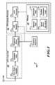
- FIGURE 1 is a simplified block diagram of a Global Navigation Satellite System (GNSS) device embodiment
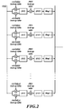
- FIGURE 2 is a block diagram illustrating a GNSS satellite signal correlation process using an Fast Fourier Transform (FFT) analysis process
- FIGURE 3 is a conceptually illustrative three dimensional view of a plurality of frequency bins corresponding to a detected GNSS satellite signal
- FIGURE 4 is a conceptually illustrative three dimensional view of a reduced number of frequency bins that are searched during the GNSS satellite signal acquisition process
- FIGURE 5 is a conceptually illustrative three dimensional view of frequency bins that are searched during the GNSS satellite signal acquisition process after adjustment of a signal strength threshold by an embodiment of a GNSS device;
- FIGURE 6 is a conceptually illustrative three dimensional view of finer resolution frequency bins that are searched during the GNSS satellite signal acquisition process.
- Embodiments of a Global Navigation Satellite System (GNSS) device 100 such as the Global Positioning System (GPS) device, uses estimated satellite orbital position information obtained from almanac and/or ephemeris data for setting signal strength threshold, so that GNSS satellite signal acquisition times are reduced.
- the almanac and/or ephemeris data may be retrieved from memory or received in a detected satellite signal.
- the GNSS device 100 may be interchangeably referred to as a GPS device, satellite position detection device, or the like.
- FIGURE 1 is a simplified block diagram of a GNSS device embodiment.
- the GNSS device 100 includes a GNSS front end 102 and a GNSS processor system 104.
- the GNSS front end 102 receives the incoming analog GNSS satellite signal from a GNSS antenna 106, which detects signals from a plurality of visible GNSS satellites.
- the analog GNSS satellite signal is amplified by a low noise amplifier 108 and is filtered by a bandpass filter 110.
- the low noise amplifier 108 and the bandpass filter 110 may be provided in multiple stages, if desired.
- the analog GNSS satellite signal at the output of the bandpass filter 110 is downconverted in a frequency downconverter 112 by mixing the analog GNSS satellite signal with a local oscillator signal to shift the carrier frequency of the incoming analog GNSS satellite signal to a lower and more manageable frequency band. This downconversion can be performed multiple times to bring the frequency of the analog GNSS satellite signal down in steps to the final desired frequency. Each mixing operation produces a high frequency information band along with the lower frequency band. Therefore, each mixing stage of the frequency downconverter 112 may require a bandpass filter to remove the information in the corresponding higher frequency band.
- a frequency reference 114 provides a frequency reference for the frequency downconverter 112.
- the GNSS processor system 104 includes an analog to digital (A/D) sampler 116 which, in response to the signal from the frequency reference 114, converts the downconverted analog GNSS satellite signal to a digital GNSS satellite signal.
- a GNSS processor 118 uses the downconverted digital GNSS signal to first determine ranging and satellite information for the GNSS satellites in view of its antenna at the time, and to then determine latitude, longitude, altitude, and/or GNSS system time.
- Acquisition and tracking can be performed by the GNSS processor 118 in software.
- Acquiring and tracking the GNSS satellite signals principally means that the code and frequency offsets between GNSS satellites and GNSS device 100 are determined and tracked on a regular basis. A typical value of how often the tracking loops execute is 1000 times per second. GNSS satellite position is determined from these offsets, but it can be done faster or slower depending on the processing capability available in the GNSS receiver.
- a GNSS satellite transmits a signal that is detected by the GNSS device 100.
- the transmitted GNSS signal from each GNSS satellite is modulated with a psuedo-noise (PN) code that is a sequence of 1023 chips.
- PN psuedo-noise
- the GNSS satellite signal is modulated by an additional data stream which contains almanac data and the ephemeris data.
- the PN code in the received GNSS satellite signal is periodically repeated.
- the GNSS device 100 generates a plurality of replica PN codes at many different frequencies, which are compared with the received GNSS satellite signal using a correlation process.
- FFT Fast Fourier Transform
- An exemplary FFT process is described in U.S. Patent publication 2007/0046536 to Zhike et. al , entitled “Fast Fourier Transform with Down Sampling Based Navigational Satellite Signal Tracking", which is incorporated by reference herein.
- Any suitable GNSS satellite tracking system that analyzes signals using a plurality of frequency bins may use embodiments described herein to more quickly and/or more accurately acquire a GNSS satellite signal.
- the FFT analysis process correlates the GNSS satellite signal information to generate correlation values that are stored into a series of frequency bins over a time range.
- the GNSS satellite signal will have its unique PN code corresponding to at least one particular frequency bin.
- the PN signal corresponds to at least one of the frequency bins that are searched by the GNSS device 100 during the GNSS signal acquisition process.
- the PN code may be detectable over a relatively small frequency range, and thus, the GNSS satellite signal may be detectable in several adjacent frequency bins depending upon the frequency range of the frequency bins defined during the FFT analysis process.
- the GNSS processor 28 may determine its relative distance to the GNSS satellite.
- a least squared error triangulation process is used to determine the location of the GNSS device 100 relative to the GNSS satellites (GNSS position).
- the GNSS processor 118 determines latitude and longitude of the GNSS device 100.
- the GNSS processor 118 can also determine altitude (or depth) if the GNSS device 100 operates in three dimensional space.
- the GNSS processor 118 may further determine rate and GNSS system time from the acquired GNSS signal.
- the GNSS data in a received GNSS satellite signal is processed by the GNSS processor 118 in the frequency domain (instead of the time domain).
- Frequency domain processing techniques use FFT for Wavelet Multiresolution Analysis (WMA).
- WMA Wavelet Multiresolution Analysis
- Such software based GNSS signal acquisition may be faster than hardware based signal acquisition, and software processing can eliminate much of the front end processing.
- frequency domain techniques used during signal acquisition are faster than conventional time domain techniques, there will still be a discernable amount of time required to complete the computations required for GNSS satellite signal acquisition. Thus, a delay can occur from the end of the batch data collection and the completion of the signal acquisition phase depending on the processor 118 speed.
- the GNSS system processor 118 further includes a memory 120.
- the received GNSS satellite signal includes almanac data and ephemeris data.
- the information in the received almanac data and/or ephemeris data is saved into the almanac database 122 and/or ephemeris database 124 portions of memory 120 in a suitable format, such as in a database or table.
- Coarse satellite orbital position information for a plurality of GNSS satellites resides in the almanac database 122. More accurate satellite orbital position information resides in the ephemeris database 124.
- Other embodiments may store the received almanac data and/or ephemeris data in other formats, memory regions, or even in other memory devices.
- the GNSS estimation logic 126 is software stored in memory 120 that is used to estimate GNSS satellite positions.
- the GNSS position estimation logic 126 (retrieved and executed by the GNSS processor 28) estimates orbital position of selected visible GNSS satellites based upon the satellite orbital position information in the almanac database 122 and/or the ephemeris database 124.
- Almanac data and ephemeris data is transmitted in portions in the GNSS satellite signals, and accordingly, some period of time is required to receive a complete set of almanac data and ephemeris data.
- Relatively recently acquired almanac data and ephemeris data is saved into the almanac database 122 and the ephemeris database 124, respectively, of memory 120.
- the receipt dates and times of the almanac and ephemeras data is also saved such that as assessment of the validity of the almanac data and the ephemeris data may be made by the GNSS processor 118 during the GNSS signal acquisition process.
- the almanac database 122 and/or the ephemeris database 124 must be relatively current for estimation of GNSS satellite orbital positions relative to the location of the GNSS device 100. Any suitable process for estimating the orbital position of a GNSS satellite relative to the GNSS device 100 may be used by the various embodiments of the GNSS device 100.
- the information in the almanac database 122 and/or the ephemeris database 124 must be relatively current.
- a coarse satellite orbital position is estimated based upon the almanac information in the almanac database 122.
- a higher accuracy satellite orbital position may be estimated based upon the information in the ephemeris database 124.
- An estimate of current time may be required for either estimation.
- the GNSS satellite signal acquisition process is performed using legacy GNSS signal acquisition techniques.
- embodiments of the GNSS device 100 use the estimated satellite orbital position information to adjust at least one parameter used in the FFT analysis of the detected GNSS satellite signal.
- One or more signal processing parameters may be adjusted by the various embodiments of the GNSS device 100.
- some embodiments of the GNSS device 100 use a signal threshold 128 parameter.
- the signal threshold 128 is a predefined parameter that is initialized during startup of the GNSS device 100.
- the signal threshold 128 is used to distinguish incoming weak signals, and/or signals with high levels of noise, from an incoming GNSS satellite signal.
- the signal threshold 128 is an adjustable signal power threshold value, and/or is an adjustable signal-to-noise threshold value.
- the received signal strength and/or signal-to-noise (SN) ratio may be estimated for a signal emitted by the GNSS satellite. For example, a signal emitted from a GNSS satellite in an orbital position near the horizon will be significantly attenuated and/or distorted by the earth's atmosphere. On the other hand, a signal emitted from a GNSS satellite in an orbital position that is substantially overhead will be less attenuated and/or distorted by the earth's atmosphere.
- GNSS satellite signals that have characteristics corresponding to the estimated power and/or SN ratio can be readily identified. For example, in a plurality of frequency bins generated by the FFT analysis process, a frequency bin corresponding to the GNSS satellite will have a discernable correlation peak (a relatively high acquisition value, for example). Such frequency bins can be identified by their correlation peaks. Thus, an estimate is made to determine how much taller the correlation peak should be over the expected noise.
- the signal power threshold and/or SN ratio threshold may be adjusted based on an estimated signal strength or an expected SN ratio that is determined from the estimated orbital position of the GNSS satellite. Accordingly, frequency bins having a corresponding signal strength greater than the adjusted signal strength threshold, or having a SN ratio greater than the SN ratio threshold, are identified during the GNSS satellite signal acquisition process. The identified frequency bins are then used for the GNSS satellite signal acquisition process.
- FIGURE 2 is a block diagram illustrating a GNSS satellite signal correlation process using an FFT analysis process.
- the incoming digitized and downconverted GNSS satellite signal [r(n)] is processed by the GNSS system processor 104 ( FIGURE 1 ) using FFT techniques over a range of frequencies (f 1 , f 2 , .... f k ).
- the GNSS satellite signal r(n) is multiplied by cosine and sine functions.
- An FFT is computed of that mixed signal.
- the resultant FFT is then multiplied by the complex conjugate of the replica code for the satellite being searched at each frequency being searched. This previously determined complex conjugate FFT is retrieved from a look-up table or the like.
- the resulting complex conjugate is further processed by computing the inverse FFT (iFFT) to derive a magnitude value for each of the selected frequencies. The value is then stored in a frequency bin.
- iFFT inverse FFT
- FIGURE 3 is a conceptually illustrative three dimensional view of a plurality of frequency bins 300 corresponding to a detected GNSS satellite signal.
- Most of the frequency bins 302 have a relatively low numerical value of the acquisition ratio.
- the numerical values of the acquisition ratio correspond to the degree of correlation between the signal hypothesis generated by the GNSS device 100 and the received GNSS satellite signal.
- the low numerical values of the acquisition ratio indicates detected noise or the like in the GNSS satellite signal for that particular frequency bin.
- the frequency bins 304 have a very high value for its acquisition ratio.
- the high value of the acquisition ratio corresponds to those frequency bins 304 that identify the frequency and time of the detected GNSS satellite signal.
- Legacy GNSS devices search the entire set of frequency bins 300 looking for the frequency bins 304. It is appreciated that such a search process, which unnecessarily includes processing of information in the frequency bins 302, is very time consuming.
- FIGURE 4 is a conceptually illustrative three dimensional view of a reduced number of frequency bins that are searched during the GNSS satellite signal acquisition process performed by an embodiment of the GNSS device 100.
- one embodiment deselects some or all of the frequency bins 302 that are not expected to contain information corresponding to the GNSS satellite signal.
- identified ones of the frequencies f 1 to f k may be deselected or the like.
- Frequency bins that are deselected are identified based upon the estimated location of the GNSS satellite.
- the entire range of searchable frequency bins correspond to a range of possible locations of the GNSS satellite that is being acquired. For example, if the almanac data and/or ephemeris data is used to estimate that the GNSS satellite is directly overhead, it is appreciated that frequency bins corresponding to positions other than substantially overhead do not need to be searched. Thus, embodiments of the GNSS device 100 deselect those frequency bins that do not correspond to a substantially overhead position.
- One embodiment estimates location of the GNSS satellite based upon the almanac data and/or ephemeris data.
- the embodiment identifies a predefined range of frequency bins about the frequency bin(s) that corresponds to the estimated location. Bins outside of that range ore deselected.
- frequency bins are screened out, deleted, or otherwise identified as frequency bins that do not need to be processed during the GNSS satellite signal acquisition process. Accordingly, a reduced number of frequency bins 402 are processed by the GNSS device 100 during the GNSS satellite signal acquisition process.
- Another embodiment may select frequencies for a plurality of frequency bins that are expected to include the frequency bins 304. For example, selected ones of the frequencies f 1 to f k ( FIGURE 2 ) may be selected. Thus, signal acquisition frequency bins are selected for processing during the GNSS satellite signal acquisition process.
- FIGURE 5 is a conceptually illustrative three dimensional view of frequency bins that are searched during the GNSS satellite signal acquisition process after adjustment of a signal strength threshold 502 by an embodiment of a GNSS device 100.
- the signal strength threshold 502 may be used to effectively screen out signals having signal strengths less than the threshold.
- frequency bins which correspond to the acquired GNSS satellite signal have a discernable numerical value of the acquisition ratio.
- Other frequency bins that do not correspond to the GNSS satellite signal have no, or relatively small, numerical values for its acquisition ratio and can be identified.
- Such frequency bins are screened out, deleted, or otherwise identified as frequency bins that do not need to be processed during the GNSS satellite signal acquisition process.
- the signal strength threshold 502 has been adjusted such that frequency bins 504 having information corresponding to a signal strength less than the signal strength threshold 502 have been screened out, deleted, or otherwise identified as frequency bins that do not need to be processed during the GNSS satellite signal acquisition process.
- Some frequency bins 506 may have corresponding numerical values of their acquisition ratio that exceeds the signal strength threshold 502. These frequency bins 506 are selected for processing. In one embodiment, other screening processes or techniques may be used to screen out, delete, or otherwise identify some of these remaining frequency bins 506 as frequency bins that do not need to be further processed during the GNSS satellite signal acquisition process.
- the frequency bins 304 corresponding to the GNSS satellite signal are identifiable by their acquisition ratio numerical values which correspond to having a signal strength that is greater than or equal to the signal strength threshold 502. Accordingly, the frequency bins 304 are readily identifiable. These frequency bins 304 may be selected for processing by the GNSS device 100 during the GNSS satellite signal acquisition process.
- FIGURE 6 is a conceptually illustrative three dimensional view of finer resolution frequency bins 602 that are searched during the GNSS satellite signal acquisition process.
- frequency bins that are expected to contain information corresponding to the GNSS satellite signal may be identified. Such bins are identifiable by their time and by frequency.
- An alternative embodiment of the GNSS device 100 uses this information to construct higher resolution frequency bins 602. That is, the number of frequency bins 602 that are processed remains the same, or at least remain at a relatively large number compared to the number of bins 402 ( FIGURE 4 ).
- each frequency bin 602 corresponds to a narrower time period and/or a narrower frequency range.
- the total frequency range of the processed frequency bins 602 is from 1.0415 x 10 7 Hz to 1.0420 x 10 7 Hz.
- the total frequency range of the processed frequency bins 300 ( FIGURE 3 ) is from 1.0415 x 10 7 Hz to 1.0425 x 10 7 Hz.
- the frequency range of each frequency bin 602 is half of the frequency range of the frequency bins 300 ( FIGURE 3 ).
- Adjusting the time period and/or a frequency range so that the frequency bins have a higher resolution allows identification of the GNSS satellite signal with greater precision.
- the satellite's orbital position can be determined with a greater accuracy.
- the GNSS satellite signal may be more accurately tracked since its signal has been located with a higher degree of accuracy by using the higher resolution frequency bins 602 that correspond to a smaller time period and/or frequency range.
Landscapes
- Engineering & Computer Science (AREA)
- Radar, Positioning & Navigation (AREA)
- Remote Sensing (AREA)
- Computer Networks & Wireless Communication (AREA)
- Physics & Mathematics (AREA)
- General Physics & Mathematics (AREA)
- Position Fixing By Use Of Radio Waves (AREA)
Applications Claiming Priority (1)
| Application Number | Priority Date | Filing Date | Title |
|---|---|---|---|
| US12/033,822 US8106822B2 (en) | 2008-02-19 | 2008-02-19 | System and method for GNSS position aided signal acquisition |
Publications (3)
| Publication Number | Publication Date |
|---|---|
| EP2093585A2 true EP2093585A2 (de) | 2009-08-26 |
| EP2093585A3 EP2093585A3 (de) | 2011-05-18 |
| EP2093585B1 EP2093585B1 (de) | 2012-12-26 |
Family
ID=40637226
Family Applications (1)
| Application Number | Title | Priority Date | Filing Date |
|---|---|---|---|
| EP09152333A Ceased EP2093585B1 (de) | 2008-02-19 | 2009-02-06 | System und Verfahren zur GNSS-positionsgestützten Signalerfassung |
Country Status (4)
| Country | Link |
|---|---|
| US (1) | US8106822B2 (de) |
| EP (1) | EP2093585B1 (de) |
| JP (1) | JP2009198499A (de) |
| CA (1) | CA2654142C (de) |
Cited By (1)
| Publication number | Priority date | Publication date | Assignee | Title |
|---|---|---|---|---|
| US8929571B2 (en) | 2010-02-04 | 2015-01-06 | Goldmund Monaco Sam | Method for creating an audio environment having N speakers |
Families Citing this family (21)
| Publication number | Priority date | Publication date | Assignee | Title |
|---|---|---|---|---|
| US7811282B2 (en) * | 2000-03-06 | 2010-10-12 | Salient Surgical Technologies, Inc. | Fluid-assisted electrosurgical devices, electrosurgical unit with pump and methods of use thereof |
| JP5321499B2 (ja) * | 2010-02-23 | 2013-10-23 | セイコーエプソン株式会社 | 信号捕捉方法 |
| JP5321500B2 (ja) * | 2010-02-23 | 2013-10-23 | セイコーエプソン株式会社 | 信号捕捉方法 |
| KR101180689B1 (ko) | 2010-12-13 | 2012-09-07 | 건국대학교 산학협력단 | 위성 좌표 예측을 이용한 수신기 좌표 계산 장치 |
| EP2829895B1 (de) * | 2012-03-22 | 2019-11-27 | Furuno Electric Co., Ltd. | Signalsuchverfahren, signalsuchprogramm, signalsuchvorrichtung, globales navigationssatellitensystem (gnss) signalempfänger und informationsendgerät |
| US8943569B1 (en) * | 2013-10-01 | 2015-01-27 | Myth Innovations, Inc. | Wireless server access control system and method |
| CN104614739B (zh) * | 2015-01-27 | 2017-01-25 | 南京师范大学 | 基于抗干扰滤波器的北斗多频接收机信号联合跟踪方法 |
| CN104950316B (zh) * | 2015-04-20 | 2021-10-26 | 中国电子科技集团公司第二十研究所 | 一种广播星历数据的一致性检测方法、设备及系统 |
| ITUB20160628A1 (it) * | 2016-02-10 | 2017-08-10 | St Microelectronics Srl | Procedimento per predire l'orbita di un satellite e corrispondente ricevitore di segnale satellitare |
| CN106483542A (zh) * | 2016-09-19 | 2017-03-08 | 湖南泰达讯科技有限公司 | 基于北斗卫星和射频的混合定位方法及其系统 |
| US10830903B2 (en) * | 2018-03-07 | 2020-11-10 | Accord Ideation Private Limited | Low power minimal rate global navigation satellite system signal tracking system |
| CN114424619B (zh) * | 2019-09-30 | 2024-10-18 | 华为技术有限公司 | 通信方法、小区测量的方法与通信装置 |
| CN110954926B (zh) * | 2019-12-12 | 2023-08-25 | 上海航天控制技术研究所 | 一种自适应可变搜索范围的gnss信号快速捕获方法 |
| US11681052B2 (en) | 2020-01-07 | 2023-06-20 | All. Space Networks Limited | Non-cooperative position, navigation, and timing extraction from VSAT communications signals using multi-beam phased array antenna |
| US11177852B1 (en) * | 2020-09-22 | 2021-11-16 | Bae Systems Information And Electronic Systems Integration Inc. | Digital detection and tracking of signals over multiple frequency bins |
| CN112527238B (zh) * | 2020-11-25 | 2022-03-04 | 中国电子科技集团公司第五十四研究所 | 卫星导航信号相关峰低资源构建装置 |
| WO2023278368A1 (en) * | 2021-06-29 | 2023-01-05 | Raytheon Company | Configurable acquisition engine for receiver of spread spectrum signals |
| US11855683B2 (en) | 2021-06-29 | 2023-12-26 | Raytheon Company | Configurable acquisition engine for receiver of spread spectrum signals |
| CN113985449A (zh) * | 2021-09-07 | 2022-01-28 | 北方雷科(安徽)科技有限公司 | 一种多门限自适应的捕获验证策略方法 |
| CN116719073B (zh) * | 2023-08-09 | 2023-10-20 | 深圳华大北斗科技股份有限公司 | 面向gnss解算域的粗差探测与剔除方法 |
| CN116774256B (zh) * | 2023-08-18 | 2023-10-24 | 长沙金维信息技术有限公司 | 一种信号频点捕获方法、系统、电子装置及存储介质 |
Citations (1)
| Publication number | Priority date | Publication date | Assignee | Title |
|---|---|---|---|---|
| US20070046536A1 (en) | 2005-08-31 | 2007-03-01 | Zhike Jia | Fast fourier transform with down sampling based navigational satellite signal tracking |
Family Cites Families (13)
| Publication number | Priority date | Publication date | Assignee | Title |
|---|---|---|---|---|
| DE3278915D1 (en) * | 1981-12-31 | 1988-09-22 | Secr Defence Brit | Receivers for navigation satellite systems |
| JPH03146890A (ja) * | 1989-11-02 | 1991-06-21 | Pioneer Electron Corp | Gps受信機の衛星電波捕捉方式 |
| JP2539535B2 (ja) * | 1990-07-06 | 1996-10-02 | 株式会社日立製作所 | 測位衛星受信信号処理方法と装置及びナビゲ―ションシステム |
| USRE37408E1 (en) * | 1993-05-21 | 2001-10-16 | Trimble Navigation Ltd. | Reduction of time to first fix in an SATPS receiver |
| JPH07140224A (ja) * | 1993-11-16 | 1995-06-02 | Nippondenso Co Ltd | スペクトル拡散信号捕捉装置 |
| JPH09304502A (ja) * | 1996-05-09 | 1997-11-28 | Matsushita Electric Ind Co Ltd | Gps受信機 |
| US6133873A (en) * | 1998-06-03 | 2000-10-17 | Krasner; Norman F. | Method and apparatus for adaptively processing GPS signals in a GPS receiver |
| US6606349B1 (en) * | 1999-02-04 | 2003-08-12 | Sirf Technology, Inc. | Spread spectrum receiver performance improvement |
| US6411892B1 (en) * | 2000-07-13 | 2002-06-25 | Global Locate, Inc. | Method and apparatus for locating mobile receivers using a wide area reference network for propagating ephemeris |
| JP2001272451A (ja) * | 2000-03-24 | 2001-10-05 | Clarion Co Ltd | Gps受信装置及び方法、gps受信用ソフトウェアを記録した記録媒体並びにナビゲーションシステム |
| JP3723492B2 (ja) * | 2001-11-12 | 2005-12-07 | クラリオン株式会社 | Gps受信装置 |
| KR100450954B1 (ko) * | 2002-06-12 | 2004-10-02 | 삼성전자주식회사 | 전세계위치확인 시스템에서 최적 위성의 선택방법 및 장치 |
| US6825805B2 (en) * | 2002-08-29 | 2004-11-30 | Qualcomm Incorporated | Search procedure for position determination system |
-
2008
- 2008-02-19 US US12/033,822 patent/US8106822B2/en not_active Expired - Fee Related
-
2009
- 2009-02-06 EP EP09152333A patent/EP2093585B1/de not_active Ceased
- 2009-02-10 JP JP2009028543A patent/JP2009198499A/ja active Pending
- 2009-02-17 CA CA2654142A patent/CA2654142C/en not_active Expired - Fee Related
Patent Citations (1)
| Publication number | Priority date | Publication date | Assignee | Title |
|---|---|---|---|---|
| US20070046536A1 (en) | 2005-08-31 | 2007-03-01 | Zhike Jia | Fast fourier transform with down sampling based navigational satellite signal tracking |
Cited By (1)
| Publication number | Priority date | Publication date | Assignee | Title |
|---|---|---|---|---|
| US8929571B2 (en) | 2010-02-04 | 2015-01-06 | Goldmund Monaco Sam | Method for creating an audio environment having N speakers |
Also Published As
| Publication number | Publication date |
|---|---|
| US8106822B2 (en) | 2012-01-31 |
| CA2654142A1 (en) | 2009-08-19 |
| CA2654142C (en) | 2016-10-11 |
| US20090207076A1 (en) | 2009-08-20 |
| EP2093585A3 (de) | 2011-05-18 |
| JP2009198499A (ja) | 2009-09-03 |
| EP2093585B1 (de) | 2012-12-26 |
Similar Documents
| Publication | Publication Date | Title |
|---|---|---|
| EP2093585B1 (de) | System und Verfahren zur GNSS-positionsgestützten Signalerfassung | |
| US8009086B2 (en) | System and method for geo-locating a receiver with reduced power consumption | |
| US6304216B1 (en) | Signal detector employing correlation analysis of non-uniform and disjoint sample segments | |
| EP1783511B1 (de) | Minimierung der Suchzeit für einen GPS-Satelliten in einem GPS-Empfänger | |
| NL2003861C2 (en) | Method and apparatus for weak data frame sync in a positioning system. | |
| US6990140B2 (en) | Signal receiver using coherent integration in interleaved time periods for signal acquisition at low signal strength | |
| CN101937074B (zh) | 获取导航比特流的方法和装置、gps接收机及其定位方法 | |
| US6150978A (en) | GPS receiver having fast resolution of carrier phase ambiguity | |
| US6836241B2 (en) | Method for optimal search scheduling in satellite acquisition | |
| JP4154609B2 (ja) | 衛星信号受信処理装置および衛星信号受信処理方法 | |
| WO2011091511A9 (en) | System, method and computer program for navigation data bit synchronization for a gnss receiver | |
| DE102009044630B4 (de) | Verfahren und Vorrichtung für eine Synchronisation von schwachen Datenbits bei einem Positionsbestimmungssystem | |
| US6643320B1 (en) | Receiver for DS-CDMA signals | |
| EP3869233A1 (de) | Detektion und abschwächung von gnss-korrelationsverzerrung | |
| US7940834B2 (en) | Signal receiver using data bit search in alternating time segments | |
| EP2243035B1 (de) | Messung des energiepotenzials (signal-rausch-verhältnis) bei empfängern digitaler globaler navigationssatellitensysteme | |
| CN115291258B (zh) | 一种gnss基带捕获方法 | |
| US20040010369A1 (en) | Gps receiver tracking system | |
| US6757610B1 (en) | Method for rapid location determination using parametric values obtained in a previous location determination | |
| Anghileri et al. | Performance evaluation of a multi-frequency GPS/Galileo/SBAS software receiver | |
| KR20030013405A (ko) | 위성 기반 위치지정 시스템, 위성 기반 위치지정시스템에서 이용하기 위한 장치, 수신기의 정확한 위치를결정하는 방법 및 상관기 출력에서의 신호를 처리하는 방법 | |
| US20100070129A1 (en) | Vehicle data recorder | |
| US20060170590A1 (en) | Selecting an optimal antenna in a GPS receiver and methods thereof | |
| EP4538748A1 (de) | Einstellung von signalerkennungsschwellen | |
| Dampf et al. | Nuisance Parameters for Bayesian Direct Position Estimation Targeting Improved Stability |
Legal Events
| Date | Code | Title | Description |
|---|---|---|---|
| PUAI | Public reference made under article 153(3) epc to a published international application that has entered the european phase |
Free format text: ORIGINAL CODE: 0009012 |
|
| 17P | Request for examination filed |
Effective date: 20090206 |
|
| AK | Designated contracting states |
Kind code of ref document: A2 Designated state(s): AT BE BG CH CY CZ DE DK EE ES FI FR GB GR HR HU IE IS IT LI LT LU LV MC MK MT NL NO PL PT RO SE SI SK TR |
|
| AX | Request for extension of the european patent |
Extension state: AL BA RS |
|
| PUAL | Search report despatched |
Free format text: ORIGINAL CODE: 0009013 |
|
| REG | Reference to a national code |
Ref country code: DE Ref legal event code: R079 Ref document number: 602009012166 Country of ref document: DE Free format text: PREVIOUS MAIN CLASS: G01S0001000000 Ipc: G01S0019240000 |
|
| AK | Designated contracting states |
Kind code of ref document: A3 Designated state(s): AT BE BG CH CY CZ DE DK EE ES FI FR GB GR HR HU IE IS IT LI LT LU LV MC MK MT NL NO PL PT RO SE SI SK TR |
|
| AX | Request for extension of the european patent |
Extension state: AL BA RS |
|
| RIC1 | Information provided on ipc code assigned before grant |
Ipc: G01S 19/24 20100101AFI20110414BHEP Ipc: G01S 1/00 20060101ALN20110414BHEP |
|
| 17Q | First examination report despatched |
Effective date: 20110930 |
|
| AKX | Designation fees paid |
Designated state(s): DE |
|
| RIC1 | Information provided on ipc code assigned before grant |
Ipc: G01S 19/24 20100101AFI20120806BHEP Ipc: G01S 1/00 20060101ALN20120806BHEP |
|
| GRAP | Despatch of communication of intention to grant a patent |
Free format text: ORIGINAL CODE: EPIDOSNIGR1 |
|
| GRAS | Grant fee paid |
Free format text: ORIGINAL CODE: EPIDOSNIGR3 |
|
| GRAA | (expected) grant |
Free format text: ORIGINAL CODE: 0009210 |
|
| AK | Designated contracting states |
Kind code of ref document: B1 Designated state(s): DE |
|
| REG | Reference to a national code |
Ref country code: DE Ref legal event code: R096 Ref document number: 602009012166 Country of ref document: DE Effective date: 20130228 |
|
| PLBE | No opposition filed within time limit |
Free format text: ORIGINAL CODE: 0009261 |
|
| STAA | Information on the status of an ep patent application or granted ep patent |
Free format text: STATUS: NO OPPOSITION FILED WITHIN TIME LIMIT |
|
| 26N | No opposition filed |
Effective date: 20130927 |
|
| REG | Reference to a national code |
Ref country code: DE Ref legal event code: R097 Ref document number: 602009012166 Country of ref document: DE Effective date: 20130927 |
|
| PGFP | Annual fee paid to national office [announced via postgrant information from national office to epo] |
Ref country code: DE Payment date: 20170227 Year of fee payment: 9 |
|
| REG | Reference to a national code |
Ref country code: DE Ref legal event code: R119 Ref document number: 602009012166 Country of ref document: DE |
|
| PG25 | Lapsed in a contracting state [announced via postgrant information from national office to epo] |
Ref country code: DE Free format text: LAPSE BECAUSE OF NON-PAYMENT OF DUE FEES Effective date: 20180901 |
|
| P01 | Opt-out of the competence of the unified patent court (upc) registered |
Effective date: 20230525 |