EP1965222A2 - Method and device for tracking a minimum of one moving object - Google Patents
Method and device for tracking a minimum of one moving object Download PDFInfo
- Publication number
- EP1965222A2 EP1965222A2 EP08400005A EP08400005A EP1965222A2 EP 1965222 A2 EP1965222 A2 EP 1965222A2 EP 08400005 A EP08400005 A EP 08400005A EP 08400005 A EP08400005 A EP 08400005A EP 1965222 A2 EP1965222 A2 EP 1965222A2
- Authority
- EP
- European Patent Office
- Prior art keywords
- track
- route
- active
- curve
- parameters
- Prior art date
- Legal status (The legal status is an assumption and is not a legal conclusion. Google has not performed a legal analysis and makes no representation as to the accuracy of the status listed.)
- Granted
Links
- 238000000034 method Methods 0.000 title claims abstract description 36
- 238000005259 measurement Methods 0.000 claims description 48
- 230000000694 effects Effects 0.000 claims description 20
- 230000001419 dependent effect Effects 0.000 claims description 6
- 230000002457 bidirectional effect Effects 0.000 claims description 5
- 230000009471 action Effects 0.000 description 19
- 238000012544 monitoring process Methods 0.000 description 4
- 238000012986 modification Methods 0.000 description 2
- 230000004048 modification Effects 0.000 description 2
- 241001136792 Alle Species 0.000 description 1
- 230000001154 acute effect Effects 0.000 description 1
- 230000006978 adaptation Effects 0.000 description 1
- 238000013459 approach Methods 0.000 description 1
- 238000004364 calculation method Methods 0.000 description 1
- 238000011161 development Methods 0.000 description 1
- 230000018109 developmental process Effects 0.000 description 1
- 238000002474 experimental method Methods 0.000 description 1
- 238000013213 extrapolation Methods 0.000 description 1
- 230000000977 initiatory effect Effects 0.000 description 1
- 238000007781 pre-processing Methods 0.000 description 1
- 230000008569 process Effects 0.000 description 1
- 238000012545 processing Methods 0.000 description 1
- 230000004044 response Effects 0.000 description 1
- 238000010972 statistical evaluation Methods 0.000 description 1
- 238000007619 statistical method Methods 0.000 description 1
- 230000002123 temporal effect Effects 0.000 description 1
Images


Classifications
-
- G—PHYSICS
- G01—MEASURING; TESTING
- G01S—RADIO DIRECTION-FINDING; RADIO NAVIGATION; DETERMINING DISTANCE OR VELOCITY BY USE OF RADIO WAVES; LOCATING OR PRESENCE-DETECTING BY USE OF THE REFLECTION OR RERADIATION OF RADIO WAVES; ANALOGOUS ARRANGEMENTS USING OTHER WAVES
- G01S7/00—Details of systems according to groups G01S13/00, G01S15/00, G01S17/00
- G01S7/003—Transmission of data between radar, sonar or lidar systems and remote stations
-
- G—PHYSICS
- G01—MEASURING; TESTING
- G01S—RADIO DIRECTION-FINDING; RADIO NAVIGATION; DETERMINING DISTANCE OR VELOCITY BY USE OF RADIO WAVES; LOCATING OR PRESENCE-DETECTING BY USE OF THE REFLECTION OR RERADIATION OF RADIO WAVES; ANALOGOUS ARRANGEMENTS USING OTHER WAVES
- G01S13/00—Systems using the reflection or reradiation of radio waves, e.g. radar systems; Analogous systems using reflection or reradiation of waves whose nature or wavelength is irrelevant or unspecified
- G01S13/66—Radar-tracking systems; Analogous systems
- G01S13/72—Radar-tracking systems; Analogous systems for two-dimensional tracking, e.g. combination of angle and range tracking, track-while-scan radar
- G01S13/723—Radar-tracking systems; Analogous systems for two-dimensional tracking, e.g. combination of angle and range tracking, track-while-scan radar by using numerical data
- G01S13/726—Multiple target tracking
-
- G—PHYSICS
- G01—MEASURING; TESTING
- G01S—RADIO DIRECTION-FINDING; RADIO NAVIGATION; DETERMINING DISTANCE OR VELOCITY BY USE OF RADIO WAVES; LOCATING OR PRESENCE-DETECTING BY USE OF THE REFLECTION OR RERADIATION OF RADIO WAVES; ANALOGOUS ARRANGEMENTS USING OTHER WAVES
- G01S13/00—Systems using the reflection or reradiation of radio waves, e.g. radar systems; Analogous systems using reflection or reradiation of waves whose nature or wavelength is irrelevant or unspecified
- G01S13/87—Combinations of radar systems, e.g. primary radar and secondary radar
-
- G—PHYSICS
- G01—MEASURING; TESTING
- G01S—RADIO DIRECTION-FINDING; RADIO NAVIGATION; DETERMINING DISTANCE OR VELOCITY BY USE OF RADIO WAVES; LOCATING OR PRESENCE-DETECTING BY USE OF THE REFLECTION OR RERADIATION OF RADIO WAVES; ANALOGOUS ARRANGEMENTS USING OTHER WAVES
- G01S13/00—Systems using the reflection or reradiation of radio waves, e.g. radar systems; Analogous systems using reflection or reradiation of waves whose nature or wavelength is irrelevant or unspecified
- G01S13/88—Radar or analogous systems specially adapted for specific applications
- G01S13/91—Radar or analogous systems specially adapted for specific applications for traffic control
- G01S13/917—Radar or analogous systems specially adapted for specific applications for traffic control for marine craft or other waterborne vessels
-
- G—PHYSICS
- G08—SIGNALLING
- G08G—TRAFFIC CONTROL SYSTEMS
- G08G3/00—Traffic control systems for marine craft
-
- G—PHYSICS
- G08—SIGNALLING
- G08G—TRAFFIC CONTROL SYSTEMS
- G08G5/00—Traffic control systems for aircraft, e.g. air-traffic control [ATC]
- G08G5/0073—Surveillance aids
- G08G5/0082—Surveillance aids for monitoring traffic from a ground station
Definitions
- the invention relates to a method and a device for tracking at least one moving object.
- Such devices are e.g. known as Tracker, Radar Extractor Tracker or Multi Sensor Tracker (MST), and others. used in coastal surveillance, river monitoring, port monitoring, airspace surveillance and tarmac monitoring to monitor ship and / or air traffic / taxiway traffic and to take necessary action if necessary.
- An MST is a device that is able to jointly evaluate measurement data from several sensors.
- Fig. 1 shows a coastline 10, a sea 12, an island 13 and three ships 12 moving on the sea 12.
- the sensor devices 20, 20 ', 21 and 21' can already perform preprocessing of the measurement data, and the possibly preprocessed measurement data "DATA" 24 are transmitted via data lines 23 or a radio network to an input interface "IN" 43 of a multi sensor tracker (MST) 32 supplied, which is located for example in a data center 34.
- MST multi sensor tracker
- the MST 32 In addition to the measurement data of the sensor devices 20, 21, the MST 32 also has what is known as a priori knowledge, map information "MAP" 40, area information "AREAS” 41 and route information "ROUTES” 42 being shown in this example.
- the MST 32 processes the measurement data arriving from the sensor devices 20, 21 with the aid of a priori knowledge and generates so-called tracks therefrom. Tracks are images in the MST 32 from the state of the real ships 14.
- the movement data of the track (from position to rotational speed) is also called the state vector, and the entirety of the track data is called the state of the track.
- object is actually the real object such as means a ship floating on a river
- track denotes an image of the object in the system
- the terms are often used interchangeably as in the following description, since the tracking of the objects in the MST 32 is usually associated with the movement of the real Objects explained.
- a further intermediate system 54 may be provided which allows data exchange between the stations 50, 50 ', 50 ", for example, a user of the workstation 50 may designate a ship 14 or its track 45, 46 as possible smugglers, and on a work station 50 'arranged on a coastal surveillance boat, this identifier is also displayed by means of the intermediate system 54.
- a user of the workstation 50 via the data line 51 data "INFO" 47 such. sends a ship's name received by radio to the MST 32.
- the MST 32 may also be assigned a recording device "REC" 56, e.g. to be able to check the shipping traffic before a misfortune arrived or to carry out statistical evaluations.
- the MST 32 is a very complex system, since it has to take into account, for example, that the areas measured by the sensor devices 20, 21 partially overlap, the measured data of the individual sensor devices 20, 21 arrive at longer intervals and partly late and not all areas through the sensor devices 20, 21 are detected. Despite these difficulties, the MST 32 should generate tracks 45 whose state, including the state vector, matches the actual state of the ships 14 as well as possible and contains as few errors as possible.
- the a priori knowledge makes it much easier for the MST 32 to track ships or objects in general.
- the area information "AREAS" 41 it can be defined in which area of the monitored area is land (so-called land areas), and accordingly the tracking of a track 45 can be terminated if it moves to such a land area since it is either not a ship or there are corresponding measurement errors. It can also be defined, for example, that in certain areas in which, for example, a large amount of noise occurs, no new tracks are generated (so-called non automatic initiation areas), or that in certain areas tracks are not removed (cancellation control areas).
- the map information "MAP" 40 gives the MST 32 more information about the area to be monitored, and the MST 32 can, for example, automatically generate area information "AREAS" 41 from the map information 40.
- the map information is also used at the workstations 50, 50 ', 50 "for control and labor convenience by superimposing thereon the objects and area information" AREAS "41.
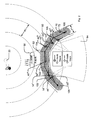
- Fig. 2 shows an application example of the route information "ROUTES" 42 in the case of port monitoring. Shown are both the real conditions and the corresponding image in the MST 32.
- the radar sensor device 20 is arranged to monitor the channel 60. It is a rotatable directional radiator / receiver, which scans during one revolution, the region 61 indicated by concentric circles. A region 62 of the channel 60 is in the radar shadow 64 of a factory 68, ie, due to the size of the factory 68, a measurement in the region 62 by the radar sensor device 20 is not possible because the radar beams radiated by the radar sensor device through the factory 68 are completely reflected or absorbed. On the channel 60 six ships 14 'to 14 VI are shown.
- the ship 14 is just moving towards the area 62, and in this area 62 no more measurement data is being generated to the ship 14".
- Shown superposition is the MST-internal image with six tracks 45 'to 45 VI and associated speed indicators, wherein the tracks 45' to 45 VI 'correspond to the vessels 14 to 14 VI, and a route 70, which corresponds to the traveling road in the channel 60th
- the route 70 is defined and represented in the form of a polygon, and the route 70 is assigned a width (lateral extent with respect to the longitudinal route position) 71.
- the MST 32 may e.g. if, when a ship 14 enters the radar shadow area 64 for the corresponding track 45, there are no measured data left, assuming that the ship continues to travel in the same direction at the same speed. However, this may result in e.g. the track 45 "of the ship 14" in the MST 32 is moved into an area defined as land area and therefore is removed from the list of tracks 45 to the tracked ships 14, or the state of the track to the ship 14 "has been inaccurate a rectilinear movement far enough away from the true position of the ship that after leaving the area 62, no assignment of the measurements to the corresponding track 45 is possible and possibly a new track 45 is erroneously generated.
- the driveway of the ships is largely predetermined, and therefore the route 70 is defined to approximately correspond to the driveway in the radar shadow area 64.
- the MST 32 can now check if the track is on route 70 in case there is no current measurement data for a track. If so, then the MST 32 may move the track along the route 70 using the route parameters, as shown e.g. at the track 45 '' 'to the ship 14' '' is shown. For the track 45 '' 'of the ship 14' '', the route 70 is active, and the track 45 '' 'is therefore moved along the route 70, although there are no current measurement data for the ship 14' ''. Thus, with a curvature of the route 70, the track 45 will also move with a curve, i.e., the effect of the route will depend on the position of the track relative to the route.
- Route 70 significantly improves tracking of vessels 14 'through 14'''''.
- the extrapolation of the movement of the tracks becomes more precise, and their stability and possible dynamics are increased.
- the use of the routes 70 can be divided into two steps. First, it is determined based on predetermined criteria whether a route 70 is active for a track. If so, in a second step, the state of the track is influenced in dependence on the route parameters, thus assisting the tracking of the ship.
- the curve can be defined in several ways, with an open polygon requiring less computational power than simple calculations, such as a spline curve.
- the curve can also be composed of several contiguous sub-curves and have different curvatures.
- the route 70 can thus also be referred to as stationary.
- the curve defines one or two predetermined directions along the curve.
- activity criteria may have such dependencies depending on the implementation: "lateral width”, “minimum speed”, “maximum speed” and “maximum angular range”, which in turn are dependent on the activity criterion "bidirectionality”.
- One way to find the curve at the track's location is to plot the perpendicular from the track to the curve and select the resulting curve point. For this purpose, it is advantageous if the curve has no acute angle.
- a route is e.g. only active if all criteria are fulfilled (logical AND operation).
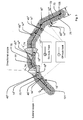
- Fig. 3 shows a route 70 with a unidirectional curve 72 and a width 71, which results from twice the lateral width 79.
- the maximum angle deviation 74 is plotted at two locations 75 and 76 respectively to the left and to the right of the direction indicated by the curve 72 locally.
- Six tracks 45 'to 45 VI are associated with speed indicator lines 15' to 15 VI shown, and they correspond to the vessels 14 'to 14 VI.
- the criterion "maximum angle deviation” is fulfilled at this time eg by the tracks 45 ", 45"'and 45 IV , since their angular deviation between the direction of movement 15 indicated by the tracks 45 and the direction of the route 70 is smaller than that Maximum angular deviation is, see eg angle deviation 77 of the track 45 ".
- the track 45 'does not fulfill this criterion since it is a unidirectional route 70 and the track 45' or the ship 14 'moves in the opposite direction. Thus, the angular deviation is too large.
- the lateral width criterion of the route is not met by Track 45 VI , because it is outside Route 70.
- the remaining tracks (ships) fulfill the criterion.
- the route becomes active for tracks 45 ", 45 '" and 45 IV , and these tracks will be correspondingly bright Circle and a bright speed indicator highlighted.
- the remaining tracks do not meet at least one of the above criteria, and they are therefore displayed dark.
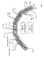
- Fig. 4 shows a route 70 and tracks (ships) 14 'to 14 VI accordingly Fig. 3 ,
- the curve 72 is defined as bidirectional.
- the maximum angular deviation 74 is applied in both directions of the curve 72.
- track 45 ' which travels substantially right-to-left on route 72, meets the criterion of maximum angular deviation, and because it also satisfies the criterion of "lateral width", the route is active for track 45'. and he is bright.
- Fig. 2 additionally shows the application of the criterion "No current measurement data available". Outside the shadow area 64, the sensor device 20 provides measurement data, and therefore the criterion "no current measurement data present" is not met for the tracks 45 ', 45 "and 45 IV to 45 VI , therefore these tracks are displayed dark and the route 70 is not active For Route 45 "'Route 70 is active and it is highlighted.
- An influencing of the movement or of the state of the track can be effected, for example, by the fact that the MST 32 generates suitable pseudo-measurement data for the desired movement and feeds the measurement data processing. It is not true measurement data of a sensor device, but artificially generated measurement data to achieve the desired movement of the track.
- the action “maintain lateral distance” can be realized, for example, by giving the system 32 a pseudo-position of the corresponding ship instead of a non-existent radar position measurement, which follows the desired path along the route, cf. Fig. 5 .
- the vectorial speed of the track can be set in the local direction of the curve, cf. Fig. 6 ,
- a route also has significant advantages in the actions, since the actions for the tracks can be carried out depending on the local property of the curve with respect to the position of the track, in particular with the actions “adjust position” and “maintain lateral distance”. The effect of the route is thus locally dependent.
- the accuracy of the lateral distance, the longitudinal movement and the compliance with the speed can also be predetermined or configured, e.g. in the form of the standard deviation.
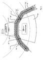
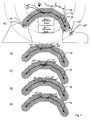
- Fig. 5 shows the temporal track course 16 of a track 45 'for a ship 14' moving through a radar shadow area 64, the activity criterion "no current measurement data present" being switched on.
- the vessel 14' travels into the radar shadow area 64, and the route 70 becomes active for the associated track 45 '(dashed portion of the track course 16).
- the "adjust position" and “maintain lateral distance” actions are on, and therefore the lateral distance 17 between the curve 72 and the track 45 'at location 16' is determined, and track 45 'is detected by the MST 32 is further moved along the curve 72, wherein the initially determined lateral distance 17 - preferably by a control - held constant (ie largely maintained), so that the track 45 'at the exit of the associated ship 14' from the Radarschatten Scheme at point 16 "a lateral distance 17 ', which substantially corresponds to the initial lateral distance 17.
- FIG. 6 Figure 16 shows the track course 16 to a track 45 'for passing through a radar shadow area 64 Fig. 5 Moving ship 14 ', with the activity criterion "No current measurement data available" is turned on. At a location 16 ', the vessel 14' travels into the radar shadow area 64 and the route 70 becomes active for the associated track 45 '(dashed portion of the lane 16).
- the lateral distance 17 of the track 45 'when entering the ship 14' into the radar shadow area 64 is not necessarily constant during the time of the activity of the route 70.
- the track pattern 16 of the track 45 'or its speed becomes according to the direction of the curve 72 adjusted, but the lateral distance changes and becomes smaller.
- the adaptation of the track 45' to the new measured values takes place there, depending on the response of the MST 32 or less clear jump of the track to the right (seen in the direction of travel).
- Routes are particularly useful when there are areas for which there is generally no radar sensor data (eg, the radar shadow area to the left of the island 13 in FIG Fig. 1 or the radar shadow area 64 in FIG Fig. 2 ) or only for certain, eg very large ships sensor data are determined (eg, below a arranged on a hill radar device).
- route parameters can be optimized, e.g. through statistical analysis of shipping traffic.
- the largely freely configurable route parameters make it possible to respond to special situations. If it is e.g. There are problems that ships 14 'on a certain route are removed too early from the tracking or from the MST 32 because of missing measurement data, this can be counteracted via the route parameters "minimum service life” or "minimum service life”.
- Fig. 7a to Fig. 7e show an application for routes in close-by navigation lanes in opposite directions.
- a ship 14 ' is going through the channel 60 from left to right and a ship 14 "from right to left ..
- a ship 14"' traverses the channel 60 from left to right and is in the middle of the channel.
- route parameter "no current measurement data present" is set in the route 70, the route 70 is not active, since all ships 14 can be detected by the radar 20.
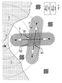
- Fig. 8 shows an application case of two intersecting waterways.
- a route 70 is defined for the first waterway (left-right) and a route 70 'for the second waterway (top-down).
- a first ship 14 ' is on route 70, a second ship 14 "on route 70', and a third ship 14"'is not on any of the routes.
- the use of the routes can here eg with the criterion "None current measurement data available "and the action" adapt position "can be used Alternatively, the routes can be selected short and used for all tracks 45 (deactivated" No current measurement data available ”) because the movement determined by the routes is over short distances usually coincide well with reality.
- the quality of the tracks and thus the quality of tracking the objects can be significantly improved, and the tracks are more reliable than tracking without routes.
- the tracks are therefore more consistent with the real objects, and this also increases the quality of the MST 32 as a whole.
- the use of routes also supports overall tracking, which can reduce the computing power required, especially in large applications.
- an established MST 32 with routes 70 well-tuned to the local conditions is much more accurate and better than an MST 32 without such routes.
- routes 70 may be required.
Landscapes
- Engineering & Computer Science (AREA)
- Radar, Positioning & Navigation (AREA)
- Remote Sensing (AREA)
- Physics & Mathematics (AREA)
- General Physics & Mathematics (AREA)
- Computer Networks & Wireless Communication (AREA)
- Aviation & Aerospace Engineering (AREA)
- Electromagnetism (AREA)
- Ocean & Marine Engineering (AREA)
- Traffic Control Systems (AREA)
- Navigation (AREA)
- Closed-Circuit Television Systems (AREA)
Abstract
Description
Die Erfindung betrifft ein Verfahren und eine Vorrichtung zur Verfolgung mindestens eines sich bewegenden Objekts.The invention relates to a method and a device for tracking at least one moving object.
Derartige Vorrichtungen sind z.B. unter den Bezeichnungen Tracker, Radar Extraktor-Tracker oder Multi Sensor Tracker (MST) bekannt und werden u.a. bei der Küstenüberwachung, Flussüberwachung, Hafenüberwachung, Luftraumüberwachung und Rollfeldüberwachung eingesetzt, um den Schiffs- und/oder Flugverkehr/Rollfeldverkehr zu beobachten und ggf. erforderliche Maßnahmen zu ergreifen. Ein MST ist eine Vorrichtung, die in der Lage ist, Messdaten mehrerer Sensoren gemeinsam auszuwerten.Such devices are e.g. known as Tracker, Radar Extractor Tracker or Multi Sensor Tracker (MST), and others. used in coastal surveillance, river monitoring, port monitoring, airspace surveillance and tarmac monitoring to monitor ship and / or air traffic / taxiway traffic and to take necessary action if necessary. An MST is a device that is able to jointly evaluate measurement data from several sensors.
Es ist daher eine Aufgabe der Erfindung, ein neues Verfahren und eine neue Vorrichtung zur Verfolgung mindestens eines sich bewegenden Objekts bereitzustellen.It is therefore an object of the invention to provide a new method and apparatus for tracking at least one moving object.
Diese Aufgabe wird gelöst durch ein Verfahren gemäß Anspruch 1 und eine Vorrichtung gemäß Anspruch 49.This object is achieved by a method according to claim 1 and an apparatus according to claim 49.
Weitere Einzelheiten und vorteilhafte Weiterbildungen der Erfindung ergeben sich aus den im folgenden beschriebenen und in den Zeichnungen dargestellten, in keiner Weise als Einschränkung der Erfindung zu verstehenden Ausführungsbeispielen, sowie aus den Unteransprüchen. Es zeigt:
- Fig. 1
- eine Übersichtsdarstellung über ein erfindungsgemäßes System,
- Fig. 2
- eine schematische Darstellung einer Anwendung einer Route,
- Fig. 3
- eine schematische Darstellung einer unidirektionalen Route und deren Aktivitätskriterien
- Fig. 4
- eine schematische Darstellung einer bidirektionalen Route und deren Aktivitätskriterien
- Fig. 5
- eine schematische Darstellung einer Aktion einer Route,
- Fig. 6
- eine schematische Darstellung einer weiteren Aktion einer Route,
- Fig. 7
- ein Anwendungsbeispiel für eine Route, und
- Fig. 8
- ein Anwendungsbeispiel für zwei Routen.
- Fig. 1
- an overview of a system according to the invention,
- Fig. 2
- a schematic representation of an application of a route,
- Fig. 3
- a schematic representation of a unidirectional route and its activity criteria
- Fig. 4
- a schematic representation of a bidirectional route and its activity criteria
- Fig. 5
- a schematic representation of an action of a route,
- Fig. 6
- a schematic representation of another action of a route,
- Fig. 7
- an application example of a route, and
- Fig. 8
- an application example for two routes.
Gleiche oder gleich wirkende Teile erhalten die gleichen Bezugszeichen und werden üblicherweise nur einmal beschrieben.Identical or like parts receive the same reference numerals and are usually described only once.
Dem MST 32 steht neben den Messdaten der Sensorvorrichtungen 20, 21 auch so genanntes a priori-Wissen zur Verfügung, wobei in diesem Beispiel Karteninformationen "MAP" 40, Gebietsinformationen "AREAS" 41 und Routeninformationen "ROUTES" 42 dargestellt sind.In addition to the measurement data of the
Der MST 32 verarbeitet die von den Sensorvorrichtungen 20, 21 eingehenden Messdaten unter Zuhilfenahme des a priori-Wissens und erzeugt daraus so genannte Tracks. Tracks sind Abbilder im MST 32 vom Zustand der realen Schiffe 14.The MST 32 processes the measurement data arriving from the
Ein Track für ein Schiff 14 umfasst z.B. die folgende Information:
- Position, z.B. Lat = 47° 25,1034' N, Lon = 10° 59,6543' E (N = Nord und geographische Breite, E = Ost und geographische Länge, z.B. jeweils auf vier Nachkommastellen bei den Minuten)
- Geschwindigkeit, z.B. 10,5 Knoten
- Kurs, z.B. 133°
- Drehgeschwindigkeit, z.B. 0.01 °/s
- Name, z.B. "MS ISABEL"
- Zeitdauer der bisherigen Verfolgung, z.B. 44 min
- Zeitpunkt der letzten Messung, z.B. 2007-03-01, 16:41:43 Uhr
- Verbleibende Lebensdauer bei vollständigem Messdatenausfall, z.B. 45 s
- Eindeutige Track-Identifikationsnummer (unique track identifier)
- Position, eg Lat = 47 ° 25,1034 'N, Lon = 10 ° 59,6543' E (N = north and latitude, E = east and longitude, eg to four decimal places at the minutes)
- Speed, eg 10.5 knots
- Course, eg 133 °
- Rotational speed, eg 0.01 ° / s
- Name, eg "MS ISABEL"
- Duration of the previous pursuit, eg 44 min
- Time of the last measurement, eg 2007-03-01, 16:41:43 o'clock
- Remaining life with complete measurement data loss, eg 45 s
- Unique track identification number
Die Bewegungsdaten des Tracks (von Position bis Drehgeschwindigkeit) werden auch als Zustandsvektor bezeichnet und die Gesamtheit der Trackdaten als Zustand des Tracks.The movement data of the track (from position to rotational speed) is also called the state vector, and the entirety of the track data is called the state of the track.
Im MST 32 sind drei Tracks 45 für die drei Schiffe 14 gezeigt, und die vom MST 32 ermittelten Tracks 45 werden dann z.B. über eine Ausgabeschnittstelle 44 und eine Datenleitung 51 oder aber auch zum Teil drahtlos als Daten "TRACK" 46 an Arbeitsstationen 50, 50', 50" übermittelt. Dort werden diese ggf. auf Anzeigevorrichtungen 52 (Monitor etc.) angezeigt, um z.B. eine Küstenüberwachung zu ermöglichen.In the
Obwohl der Begriff Objekt eigentlich das reale Objekt wie z.B. ein auf einem Fluss schwimmendes Schiff bezeichnet, und der Begriff Track eine Abbildung des Objekts im System bezeichnet, werden die Begriffe wie in der folgenden Beschreibung auch häufig synonym verwendet, da man die Verfolgung der Objekte im MST 32 üblicherweise im Zusammenhang mit der Bewegung der realen Objekte erläutert.Although the term object is actually the real object such as means a ship floating on a river, and the term track denotes an image of the object in the system, the terms are often used interchangeably as in the following description, since the tracking of the objects in the
Bei großen Systemen kann ein weiteres Zwischensystem 54 vorgesehen werden, das einen Datenaustausch zwischen den Stationen 50, 50', 50" ermöglicht. So kann z.B. ein Benutzer der Arbeitsstation 50 ein Schiff 14 bzw. dessen Track 45, 46 als möglichen Schmuggler kennzeichnen, und auf einer auf einem Küstenüberwachungsboot angeordneten Arbeitsstation 50' wird diese Kennzeichnung mit Hilfe des Zwischensystems 54 ebenfalls angezeigt.For large systems, a further
Es kann auch vorgesehen werden, dass z.B. ein Anwender der Arbeitsstation 50 über die Datenleitung 51 Daten "INFO" 47 wie z.B. einen per Funk erhaltenen Schiffsnamen an den MST 32 sendet. Dem MST 32 kann auch eine Aufzeichnungsvorrichtung "REC" 56 zugeordnet werden, um z.B. den Schiffsverkehr vor einem eingetroffenen Unglück überprüfen zu können oder statistische Auswertungen durchzuführen.It can also be provided that e.g. a user of the
Der MST 32 ist ein sehr komplexes System, da er z.B. berücksichtigen muss, dass sich die von den Sensorvorrichtungen 20, 21 gemessenen Bereiche teilweise überlappen, die Messdaten der einzelnen Sensorvorrichtungen 20, 21 in größeren Abständen und zum Teil verspätet eintreffen und nicht alle Bereiche durch die Sensorvorrichtungen 20, 21 erfasst werden. Der MST 32 soll trotz dieser Schwierigkeiten Tracks 45 erzeugen, deren Zustand einschließlich Zustandsvektor möglichst gut mit dem tatsächlichen Zustand der Schiffe 14 übereinstimmt und möglichst wenig Fehler enthält.The
Das a priori-Wissen erleichtert dem MST 32 die Verfolgung der Schiffe bzw. allgemein der Objekte wesentlich.The a priori knowledge makes it much easier for the
Bei den Gebietsinformationen "AREAS" 41 kann z.B. definiert werden, in welchem Bereich des überwachten Gebiets Land ist (so genannte land areas), und dementsprechend kann die Verfolgung eines Tracks 45 beendet werden, wenn sich dieses in ein solches Landgebiet bewegt, da es sich entweder nicht um ein Schiff handelt oder aber entsprechende Messfehler vorliegen. Es kann z.B. auch definiert werden, dass in bestimmten Gebieten, in denen z.B. ein großes Störrauschen auftritt, keine neuen Tracks erzeugt werden (so genannte non automatic inititation areas), oder dass in bestimmten Gebieten Tracks nicht entfernt werden (cancellation control areas).
Die Karteninformationen "MAP" 40 geben dem MST 32 weitere Informationen über das zu überwachende Gebiet, und der MST 32 kann z.B. aus den Karteninformationen 40 automatisch Gebietsinformationen "AREAS" 41 generieren. Die Karteninformationen werden auch an den Arbeitsstationen 50, 50', 50" zur Kontrolle und Arbeitserleichterung verwendet, indem sie dort den Objekten und Gebietsinformationen "AREAS" 41 überlagert werden.For example, in the area information "AREAS" 41, it can be defined in which area of the monitored area is land (so-called land areas), and accordingly the tracking of a
The map information "MAP" 40 gives the
Der MST 32 kann z.B. dann, wenn bei einem Eintritt eines Schiffs 14 in den Radarschattenbereich 64 für den entsprechenden Track 45 keine Messdaten mehr vorliegen, annehmen, dass das Schiff mit gleich bleibender Geschwindigkeit in die gleiche Richtung weiter fährt. Dies kann jedoch dazu führen, dass sich z.B. der Track 45" des Schiffs 14" im MST 32 in einen als Landgebiet definierten Bereich hineinbewegt und daher aus der Liste der Tracks 45 zu den verfolgten Schiffen 14 entfernt wird, oder aber der Zustand des Tracks zum Schiff 14" hat sich durch die ungenaue Annahme einer geradlinigen Bewegung soweit von der wahren Position des Schiffs entfernt, dass nach dem Verlassen des Bereichs 62 keine Zuordnung der Messungen zu dem entsprechenden Track 45 möglich ist und ggf. fälschlicherweise ein neuer Track 45 erzeugt wird.The
In dem Kanal 60 ist die Fahrstraße der Schiffe jedoch weitgehend vorgegeben, und daher ist die Route 70 so definiert, dass sie in etwa der Fahrstraße im Radarschattenbereich 64 entspricht.In the
Der MST 32 kann nun für den Fall, dass für einen Track keine aktuellen Messdaten vorliegen, überprüfen, ob sich der Track auf der Route 70 befindet. Ist dies der Fall, so kann der MST 32 den Track unter Zuhilfenahme der Routenparameter entlang der Route 70 weiterbewegen, wie dies z.B. beim Track 45''' zum Schiff 14''' dargestellt ist. Für den Track 45''' des Schiffs 14''' ist die Route 70 aktiv, und der Track 45''' wird daher entlang der Route 70 weiterbewegt, obwohl keine aktuellen Messdaten für das Schiff 14''' vorliegen. Bei einer Krümmung der Route 70 führt der Track 45 somit ebenfalls eine Bewegung mit einer Krümmung durch, d.h., die Wirkung der Route ist hier abhängig von der Position des Tracks relativ zur Route.The
Durch die Verwendung der Route 70 wird die Verfolgung der Schiffe 14' bis 14'''''' deutlich verbessert. Die Extrapolation der Bewegung der Tracks wird genauer, und deren Stabilität und mögliche Dynamik wird erhöht.The use of
Die Verwendung der Routen 70 kann in zwei Schritte untergliedert werden. Als erstes wird auf Grund vorgegebener Kriterien bestimmt, ob eine Route 70 für einen Track aktiv ist. Falls ja, wird in einem zweiten Schritt der Zustand des Tracks in Abhängigkeit von den Routenparametern beeinflusst, um so die Verfolgung des Schiffs zu unterstützen.The use of the
Routen sind im MST 32 in Form von Routenparametern gespeichert. Die Routenparameter enthalten:
- eine Kurve, z.B. in Form eines offenen, ortsfesten Polygons (auch als Polylinie, Polygonzug oder Multisegmentlinie bekannt), einer Spline-Kurve oder irgendeiner anderen Form einer Kurve. Der Kurve kann auch eine Breite zugeordnet werden.
- Aktivitätskriterien
- Aktionen für den Fall, dass die entsprechende Kurve aktiv ist.
- a curve, eg in the form of an open, fixed polygon (also known as a polyline, polygon or multisegment line), a spline curve or any other shape of a curve. The curve can also be assigned a width.
- activity criteria
- Actions in case the corresponding curve is active.
Die Kurve kann auf verschiedene Arten definiert werden, wobei ein offenes Polygon auf Grund der einfachen Berechnungen weniger Rechenleistung benötigt als z.B. eine Spline-Kurve. Die Kurve 72 entspricht in
Als Aktivitätskriterien (bzw. Wirkkriterien, engl.: scope) enthalten die Routen z.B. die folgenden Informationen:
- Routenfamilien-Index zur Klassifizierung der Routen, um z.B. das Auffinden von ähnlichen Routen zu erleichtern.
- Routen-Index, der die Route eindeutig identifiziert.
- Laterale Breite: Die laterale Breite der Route kann angegeben werden, und sie gilt dann z.B. auf beiden Seiten der Kurve. Falls eine laterale Breite angegeben ist, wird z.B. als Kriterium geprüft, ob sich der Track im durch die laterale Breite definierten Bereich der Route befindet bzw., ob der nächste Abstand (das Lot) des Tracks 45 zur Kurve 71 kleiner als die laterale Breite ist. Die Breite kann dabei z.B. konstant oder abhängig von dem longitudinalen Abschnitt nicht konstant angegeben werden.
- Minimalgeschwindigkeit: Falls eine Minimalgeschwindigkeit angegeben ist, wird z.B. als Kriterium geprüft, ob der Track einen Geschwindigkeitswert hat, welcher mindestens so groß wie die Minimalgeschwindigkeit der Route ist. Hierdurch wird die Route nicht für sehr langsame bzw. stehende Tracks/Objekte angewandt. Es kann aber z.B. auch geprüft werden, ob der vektorielle Anteil der Geschwindigkeit in Richtung der Routenrichtung an der Position des Tracks mindestens so groß wie die Minimalgeschwindigkeit ist.
- Maximalgeschwindigkeit: Falls eine Maximalgeschwindigkeit angegeben ist, wird z.B. als Kriterium geprüft, ob der Track bzw. das Objekt einen Geschwindigkeitswert hat, welcher höchstens so groß wie die Maximalgeschwindigkeit der Route ist. Hierdurch wird eine Route nicht für sehr schnelle Tracks/Objekte angewandt, da es sich z.B. nicht um Schiffe handelt. Es kann alternativ z.B. auch geprüft werden, ob der vektorielle Anteil der Geschwindigkeit in Richtung der Routenrichtung an der Position des Tracks mindestens so groß wie die Minimalgeschwindigkeit ist.
- Höchst-Winkelabweichung: Falls eine Höchst-Winkelabweichung angegeben ist, wird z.B. als Kriterium geprüft, ob die Winkelabweichung zwischen der Bewegungsrichtung des Tracks und der Richtung der Route an der Position des Tracks kleiner als die Höchst-Winkelabweichung ist.
- Bidirektionalität: Falls für die Kurve angegeben ist, dass sie bidirektional ist, wird sie in beide Richtungen der Kurve (
vom Anfangspunkt 101zum Endpunkt 106 hin und umgekehrt) verwendet. Ansonsten wird sie unidirektional verwendet, z.B. nurvom Anfangspunkt 101zum Endpunkt 106 hin. - "Keine aktuellen Messdaten vorhanden": Falls dies definiert ist, wird als zusätzliches Kriterium geprüft, ob zu dem Track keine aktuellen Messdaten vorliegen. Die Route wird also nur angewandt, wenn über das Objekt bzw. für den Track keine aktuellen Messdaten vorliegen, weil sich das Objekt z.B. in einem Radarschatten befindet. Dass keine aktuellen Messdaten vorliegen, wird z.B. daraus gefolgert, dass erwartete neue Messdaten ausgefallen sind oder aktuelle Messdaten vorliegen, die aber keine Information über das Objekt bzw. den Track enthalten.
- Route family index for the classification of routes, for example to facilitate finding similar routes.
- Route index that uniquely identifies the route.
- Lateral width: The lateral width of the route can be specified, and it then applies, for example, on both sides of the curve. If a lateral width is specified, it is checked as a criterion, for example, whether the track is in through the lateral width defined range of the route or whether the next distance (the Lot) of the
track 45 to thecurve 71 is smaller than the lateral width. The width can not be specified constant, for example, constant or dependent on the longitudinal section. - Minimum speed: If a minimum speed is specified, for example, it is checked as a criterion whether the track has a speed value that is at least as great as the minimum speed of the route. This does not apply the route to very slow or standing tracks / objects. However, it can also be checked, for example, whether the vectorial proportion of the speed in the direction of the route direction at the position of the track is at least as great as the minimum speed.
- Maximum speed: If a maximum speed is specified, for example, a criterion is checked as to whether the track or the object has a speed value which is at most as great as the maximum speed of the route. This does not apply a route to very fast tracks / objects, as it is not a ship, for example. Alternatively, for example, it may also be checked whether the vectorial component of the speed in the direction of the route direction at the position of the track is at least as great as the minimum speed.
- Maximum angle deviation: If a maximum angle deviation is specified, for example, the criterion is checked as to whether the angular deviation between the direction of movement of the track and the direction of the route at the position of the track is less than the maximum angular deviation.
- Bidirectionality: If the curve is specified to be bidirectional, it will be used in both directions of the curve (from
start point 101 toend point 106 and vice versa). Otherwise it is used unidirectionally, eg only from thestarting point 101 to theend point 106. - "No current measurement data available": If this is defined, it is checked as an additional criterion whether no current measurement data is available for the track. The route is therefore only used if there is no current measurement data for the object or for the track, for example because the object is located in a radar shadow. The fact that no current measurement data is available is inferred, for example, from the fact that expected new measurement data has failed or up-to-date measurement data are available but that contain no information about the object or the track.
Durch die in den Routenparametern enthaltene Kurve sind also insbesondere auch Aktivitätskriterien möglich, die abhängig sind von den Eigenschaften der Kurve an derBy virtue of the curve contained in the route parameters, in particular also activity criteria are possible, which are dependent on the properties of the curve on the road
Position des Tracks, und/oder auch von der Position des Tracks relativ zur Kurve und/oder der vektoriellen Geschwindigkeit des Tracks in Beziehung zur Richtung der Kurve an der Position des Tracks. Insbesondere die folgenden Aktivitätskriterien können abhängig von der Implementierung solche Abhängigkeiten aufweisen: "Laterale Breite", "Minimalgeschwindigkeit", "Maximalgeschwindigkeit" und "Höchst-Winkelbereich", welche wiederum abhängig sind von dem Aktivitätskriterium "Bidirektionalität". Eine Möglichkeit der Ermittlung der Kurve an der Position des Tracks besteht darin, dass man das Lot von dem Track auf die Kurve bildet und den sich daraus ergebenden Kurvenpunkt auswählt. Hierfür ist es vorteilhaft, wenn die Kurve keine spitzen Winkel aufweist.Position of the track, and / or also the position of the track relative to the curve and / or the vectorial speed of the track in relation to the direction of the curve at the position of the track. In particular, the following activity criteria may have such dependencies depending on the implementation: "lateral width", "minimum speed", "maximum speed" and "maximum angular range", which in turn are dependent on the activity criterion "bidirectionality". One way to find the curve at the track's location is to plot the perpendicular from the track to the curve and select the resulting curve point. For this purpose, it is advantageous if the curve has no acute angle.
Eine entsprechende Vorgehensweise ist bei Bereichen ("AREAS") nicht möglich.A corresponding procedure is not possible for areas ("AREAS").
Sofern für die Aktivität einer Route mehrere Kriterien definiert sind, wird eine Route z.B. nur dann aktiv, wenn sämtliche Kriterien erfüllt sind (logische UND-Verknüpfung).If several criteria are defined for the activity of a route, a route is e.g. only active if all criteria are fulfilled (logical AND operation).
Sechs Tracks 45' bis 45VI sind mit zugehörigen Geschwindigkeitsanzeigestrichen 15' bis 15VI dargestellt, und sie entsprechen den Schiffen 14' bis 14VI.Six tracks 45 'to 45 VI are associated with speed indicator lines 15' to 15 VI shown, and they correspond to the vessels 14 'to 14 VI.
Das Kriterium "Höchst-Winkelabweichung" ist zu diesem Zeitpunkt z.B. von den Tracks 45", 45''' und 45IV erfüllt, da deren Winkelabweichung zwischen der durch die an den Tracks 45 angezeigten Bewegungsrichtung 15 und der Richtung der Route 70 kleiner als die Höchst-Winkelabweichung ist, vgl. z.B. Winkelabweichung 77 des Tracks 45". Der Track 45' erfüllt dieses Kriterium dagegen nicht, da es sich um eine unidirektionale Route 70 handelt und der Track 45' bzw. das Schiff 14' sich in die Gegenrichtung bewegt. Damit ist die Winkelabweichung zu groß.The criterion "maximum angle deviation" is fulfilled at this time eg by the
Das Kriterium "Laterale Breite" der Route wird durch den Track 45VI nicht erfüllt, da sich dieser außerhalb der Route 70 befindet. Die übrigen Tracks (Schiffe) erfüllen das Kriterium.The lateral width criterion of the route is not met by
Sofern die beiden genannten Kriterien gesetzt sind, wird die Route also für die Tracks 45", 45''' und 45IV aktiv, und diese Tracks werden entsprechend mit einem hellen Kreis und einer hellen Geschwindigkeitsanzeige hervorgehoben. Die übrigen Tracks erfüllen zumindest eines der genannten Kriterien nicht, und sie werden daher dunkel angezeigt.Thus, if the two criteria are set, the route becomes active for
Mögliche Aktionen bei einer Aktivität einer Route werden z.B. durch die folgenden konfigurierbaren Routenparameter beeinflusst:
- Position anpassen ("update_position"): Falls eingeschaltet, wird der Zustand des Objekts derart beeinflusst, dass es sich entlang der Kurve bewegt.
- Lateralen Abstand beibehalten ("keep_lateral_distance"): Falls eingeschaltet, wird der Zustand des Objekts derart beeinflusst, dass der laterale Abstand des Objekts zur Kurve bei einer Bewegung des Objekts entlang der Kurve konstant bleibt.
- Geschwindigkeit vorgeben ("update_speed"): Falls eine Geschwindigkeit vorgegeben ist, wird die Längsgeschwindigkeit (bzw. der Betrag der Geschwindigkeit) des Tracks auf die vorgegebene Geschwindigkeit gesetzt. Dies ist z.B. vorteilhaft in Kanälen, in denen eine Höchstgeschwindigkeit von z.B. 8 Knoten vorgegeben ist, da fast alle Schiffe eine solche Höchstgeschwindigkeit einhalten werden. Diese Aktion kann z.B. auch gemeinsam mit der Aktion "Position anpassen" durchgeführt werden, um das Verfolgen eines Objekts über längere Zeit genauer zu machen.
- Geschwindigkeit beibehalten ("keep_speed"): Falls eingeschaltet, wird bei einer Aktivität einer Route die zuletzt ermittelte Geschwindigkeit des Tracks beibehalten.
- Mindestlebensdauer ("keep_alive_time"): Falls eine Mindestlebensdauer vorgegeben ist, wird die Lebensdauer des Tracks, welche z.B. abhängig von dem Zeitpunkt der letzten Messung und der gesamten Objektlebensdauer ist, auf die Mindestlebensdauer erhöht, falls sie niedriger ist. Dies kann z.B. verhindern, dass ein Track bei der Durchfahrt durch einen größeren Bereich ohne Messwerte nicht wegen des langen Fehlens von Messwerten für den Track bzw. das Objekt entfernt wird.
- Mindestlebensstrecke ("keep_alive_distance"): Falls eine Mindestlebensstrecke gesetzt ist, wird ein Track frühestens dann entfernt, wenn die zurückgelegte Strecke des Tracks seit dem Beginn der Aktivität der Route größer als die Mindestlebensstrecke ist.
- Track kennzeichnen: Falls eingeschaltet, wird im Track gespeichert, falls eine Route aktiv ist und/oder welche der Aktivitätskriterien erfüllt sind, und der Track wird mit diesen Informationen über die Ausgabeschnittstelle "OUT" 44 ausgegeben. Diese Informationen können z.B. in
den Arbeitsstationen 50 zur Klassifizierung verwendet werden, indem z.B. Routen für unverdächtige Schiffsbewegungen oder für bekannte Schmugglerrouten definiert werden.
- Adjusting the position ("update_position"): If switched on, the state of the object is influenced in such a way that it moves along the curve.
- Keep_lateral_distance: If on, affects the state of the object so that the object's lateral distance to the curve remains constant as the object moves along the curve.
- Specify speed ("update_speed"): If a speed is specified, the longitudinal speed (or the amount of speed) of the track is set to the specified speed. This is advantageous, for example, in channels in which a maximum speed of, for example, 8 knots is given, since almost all ships will comply with such a maximum speed. For example, this action can be performed in conjunction with the Adjust Position action to make tracking an object more accurate over time.
- Keep_speed: If on, an activity on a route preserves the track's most recent speed.
- Minimum lifetime ("keep_alive_time"): If a minimum life is given, the lifetime of the track, which depends on, for example, the time of the last measurement and the total object life, is increased to the minimum life, if it is lower. This can prevent, for example, that a track is not removed when passing through a larger area without measured values because of the long absence of measured values for the track or the object.
- Minimum life distance ("keep_alive_distance"): If a minimum vitality distance is set, a track will be removed at the earliest when the distance covered by the track has been greater than the minimum vital distance since the beginning of the activity of the route.
- Flag Track: If on, will be saved in the track if a route is active and / or which of the activity criteria are met, and the track will be output with this information via the output interface "OUT" 44. This information may be used, for example, in the
workstations 50 for classification by, for example, defining routes for unsuspected ship movements or for known smuggler routes.
Eine Beeinflussung der Bewegung bzw. des Zustands des Tracks kann z.B. dadurch erfolgen, dass der MST 32 für die gewünschte Bewegung geeignete Pseudo-Messdaten generiert und der Messdatenverarbeitung zuführt. Es handelt sich dabei nicht um echte Messdaten einer Sensorvorrichtung, sondern um künstlich erzeugte Messdaten zum Erreichen der gewünschten Bewegung des Tracks. Die Aktion "Lateralen Abstand beibehalten" kann z.B. dadurch verwirklicht werden, dass dem System 32 anstelle einer nicht vorhandenen Radar-Positionsmessung eine Pseudo-Position des entsprechenden Schiffs vorgegeben wird, die der gewünschten Bahn entlang der Route folgt, vgl.
Auch bei den Aktionen hat eine Route somit erhebliche Vorteile, da die Aktionen für die Tracks abhängig von der bezüglich der Position des Tracks lokalen Eigenschaft der Kurve ausgeführt werden können, insbesondere bei den Aktionen "Position anpassen" und "Lateralen Abstand beibehalten". Die Wirkung der Route ist somit örtlich abhängig.Thus, a route also has significant advantages in the actions, since the actions for the tracks can be carried out depending on the local property of the curve with respect to the position of the track, in particular with the actions "adjust position" and "maintain lateral distance". The effect of the route is thus locally dependent.
Die Genauigkeit des lateralen Abstands, der longitudinalen Bewegung und der Einhaltung der Geschwindigkeit kann ebenfalls vorgegeben bzw. konfiguriert werden, z.B. in Form der Standardabweichung.The accuracy of the lateral distance, the longitudinal movement and the compliance with the speed can also be predetermined or configured, e.g. in the form of the standard deviation.
In diesem Beispiel sind die Aktionen "Position anpassen" und "Lateralen Abstand beibehalten" eingeschaltet, und daher wird die laterale Entfernung 17 zwischen der Kurve 72 und dem Track 45' an der Stelle 16' ermittelt, und der Track 45' wird durch den MST 32 entlang der Kurve 72 weiterbewegt, wobei die anfangs ermittelte laterale Entfernung 17 - bevorzugt durch eine Regelung - konstant gehalten (d.h. weitgehend beibehalten) wird, so dass der Track 45' beim Austritt des zugehörigen Schiffs 14' aus dem Radarschattenbereich am Punkt 16" eine laterale Entfernung 17' hat, die im Wesentlichen der anfänglichen lateralen Entfernung 17 entspricht. An den Eckpunkten 72' und 72", bei denen die Route 70 aktiv ist, erfolgt ein leichtes Überschwingen des Trackverlaufs 16, da aus der Beeinflussung des Zustands des Tracks durch Pseudo-Positionsmesswerte zu diskreten vorgegebenen Zeitpunkten eine gewisse Trägheit resultiert. Sofern also von einem konstanten lateralen Abstand 17 gesprochen wird, ist es für den Fachmann selbstverständlich, dass nicht eine mathematisch perfekte Konstanz gemeint ist, sondern eine Konstanz im Rahmen der Möglichkeiten des Systems.In this example, the "adjust position" and "maintain lateral distance" actions are on, and therefore the
Im Gegensatz zur
Routen sind insbesondere dann nützlich, wenn Gebiete vorliegen, für die generell keine Radar-Sensordaten vorliegen (z.B. der Radarschattenbereich links von der Insel 13 in
Die Verwendung der Routen zur Unterstützung der Verfolgung von Objekten hat in Versuchen zu guten Ergebnissen geführt. In Abhängigkeit von der realen Situation können die Routenparameter optimiert werden, z.B. durch statistische Auswertungen des Schiffsverkehrs. Die weitgehend frei konfigurierbaren Routenparameter ermöglichen es, auch auf besondere Situationen einzugehen. Wenn es z.B. Probleme gibt, dass Schiffe 14' auf einer bestimmten Route wegen fehlender Messdaten zu früh von der Verfolgung bzw. aus dem MST 32 entfernt werden, kann dem über die Routenparameter "Mindestlebensdauer" bzw. "Mindestlebensstrecke" entgegengewirkt werden.Using routes to help track objects has yielded good results in experiments. Depending on the real situation, the route parameters can be optimized, e.g. through statistical analysis of shipping traffic. The largely freely configurable route parameters make it possible to respond to special situations. If it is e.g. There are problems that ships 14 'on a certain route are removed too early from the tracking or from the
Sofern bei der Route 70 der Routenparameter "Keine aktuellen Messdaten vorhanden" gesetzt ist, ist die Route 70 nicht aktiv, da alle Schiffe 14 von dem Radar 20 erfasst werden können.If the route parameter "no current measurement data present" is set in the
Das Gleiche gilt bei
In
In
Sofern auf einer solchen Wasserstraße 60 ein sehr dichter Schiffsverkehr auftritt, kann es vorteilhaft sein, den Routenparameter "Keine aktuellen Messdaten vorhanden" zu deaktivieren, so dass sämtliche Schiffe 14 unabhängig von den Messdaten entlang der Route 70 geführt werden.If very dense shipping traffic occurs on such a
Durch die richtige Anwendung von Routen kann wie in den Ausführungsbeispielen gezeigt die Qualität der Tracks und somit die Qualität der Verfolgung der Objekte deutlich verbessert werden, und die Tracks sind zuverlässiger als bei einer Verfolgung ohne Routen. Die Tracks stimmen somit besser mit den realen Objekten überein, und dies erhöht auch die Qualität des MST 32 insgesamt. Durch die Verwendung von Routen wird auch das Tracking insgesamt unterstützt, was insbesondere bei großen Anwendungen die benötigte Rechenleistung verringern kann.By properly applying routes, as shown in the embodiments, the quality of the tracks and thus the quality of tracking the objects can be significantly improved, and the tracks are more reliable than tracking without routes. The tracks are therefore more consistent with the real objects, and this also increases the quality of the
Die Verwendung von Routen ist auf Grund der ggf. großen Ausdehnung des beobachteten Gebiets, verbunden mit der meistens unvollständigen Sensorabdeckung des Gebiets insbesondere für die Verfolgung von Schiffen und außerdem auch für die Verfolgung von Landfahrzeugen geeignet.The use of routes is due to the possibly large extent of the observed area, combined with the mostly incomplete sensor coverage of the area especially for the tracking of ships and also suitable for the tracking of land vehicles.
Insbesondere bei großen Gebieten mit vielen Objekten, wie es z.B. bei der Küstenüberwachung eines ganzen Landes der Fall ist, ist ein eingerichteter MST 32 mit auf die lokalen Gegebenheiten gut abgestimmten Routen 70 wesentlich genauer und besser als ein MST 32 ohne solche Routen. Dabei können in einem großen System z.B. mehrere hundert Routen 70 erforderlich sein.Especially in large areas with many objects, such as e.g. in coastal surveillance of a whole country, an established
Naturgemäß sind im Rahmen der vorliegenden Erfindung vielfache weitere Abwandlungen und Modifikationen möglich.Naturally, many further modifications and modifications are possible within the scope of the present invention.
Claims (26)
bei welchem bevorzugt dann, wenn eine Route (70) für einen Track (45) aktiv ist, in dem Track (45) eine Information über die Aktivität der Route (70) gespeichert wird,
bei welchem bevorzugt die Routenparameter (42) konfigurierbar sind,
und bei welchem bevorzugt beim Vorliegen mehrerer Tracks (45) für jeden Track (45) geprüft wird, ob eine Route (70) für den betreffenden Track (45) aktiv ist.The method of claim 1, wherein when determining whether a route (70) is active for a track (45), a plurality of criteria are predetermined, and wherein a route (70) for the track (45) is only active when all specified criteria are met
in which preferably, when a route (70) is active for a track (45), information about the activity of the route (70) is stored in the track (45),
in which preferably the route parameters (42) are configurable,
and in which it is preferably checked in the presence of a plurality of tracks (45) for each track (45) whether a route (70) for the relevant track (45) is active.
wobei bevorzugt die ortsfeste Kurve (72) einer absolut festgelegten, möglichen Fahrbahn des Objekts (14) entspricht.Method according to Claim 1 or 2, in which the route parameters (42) for the route (70) have a fixed curve (72).
wherein preferably the stationary curve (72) corresponds to an absolutely fixed, possible roadway of the object (14).
bevorzugt als offenes Polygon,
wobei bevorzugt die einzelnen Punkte (101 - 106) des Polygons durch deren geographische Breite und Länge definiert werden.Method according to Claim 3, in which the curve (72) is defined as a polygon,
preferably as an open polygon,
preferably the individual points (101 - 106) of the polygon are defined by their latitude and longitude.
wobei bevorzugt die Breite (71) der Kurve (72) konstant oder abhängig von der Kurvenposition ist.A method according to claim 3 or 4, wherein the curve (72) has a width (71).
wherein preferably the width (71) of the curve (72) is constant or dependent on the curve position.
wobei bevorzugt die Kurve (72) einen Anfangspunkt (101) und einen Endpunkt (106) hat, und die Richtung vom Anfangspunkt (101) zum Endpunkt (106) hin definiert wird.Method according to one of Claims 3 to 5, in which a direction is assigned to the curve (72),
wherein preferably the curve (72) has a starting point (101) and an end point (106) and the direction from the starting point (101) to the end point (106) is defined.
wobei bevorzugt der Höchst-Winkelabweichungsbereich (74) in Form eines maximalen Abweichungswinkels definiert wird.Method according to one of claims 3 to 8, wherein in determining whether a route (70) for a track (45) is active, it is checked whether the angular deviation (77) between the direction of movement of the track (45) and the direction the route (70) is at the position of the track (45) within a predetermined maximum angular deviation range (74),
wherein preferably the maximum angular deviation range (74) is defined in the form of a maximum deviation angle.
wobei bevorzugt der Höchst-Winkelabweichungsbereich (74) in Form eines maximalen Abweichungswinkels definiert wird.The method of claim 9, wherein the route parameters (42) for the route (70) include the maximum angular deviation range (74).
wherein preferably the maximum angular deviation range (74) is defined in the form of a maximum deviation angle.
und bei welchem bevorzugt die Genauigkeit für die Beeinflussung des Zustands des Tracks (45) einstellbar ist.Method according to one of claims 3 to 10, wherein when a route (70) for a track (45) is active, the state of the track (45) is influenced such that the track (45) along the curve (45) 72) moves,
and in which preferably the accuracy for influencing the state of the track (45) is adjustable.
und bei welchem bevorzugt im Zustand des Tracks (45) gespeichert wird, wann die letzten Messdaten (24) für den Track (45) vorlagen und wann neue Messdaten (24) erwartet werden,
und bei welchem bevorzugt bei der Bestimmung, ob eine Route (70) für einen Track (45) aktiv ist, geprüft wird, ob erwartete neue Messdaten (24) ausgefallen sind.Method according to one of the preceding claims, in which, in determining whether a route (70) is active for a track (45), it is checked whether there are no current measurement data (24) for the track (45),
and in which it is preferably stored in the state of the track (45) when the last measurement data (24) was available for the track (45) and when new measurement data (24) is expected,
and in which, when determining whether a route (70) is active for a track (45), it is checked whether expected new measurement data (24) has failed.
bei welchem bevorzugt die Genauigkeit für die Beeinflussung des Zustands des Tracks (45) einstellbar ist,
und bei welchem bevorzugt der Zustand des Tracks (45) derart beeinflusst wird, dass der Betrag der Geschwindigkeit des Tracks (45) solange konstant gehalten wird, wie die Route (70) für den Track (45) aktiv ist.Method according to one of the preceding claims, in which the route parameters (42) for the at least one route (70) have a speed magnitude value and in which, when a route (70) is active for a track (45), the state of the track (45) is influenced such that the amount of the speed of the track (45) corresponds to the speed magnitude value of the route (70),
in which preferably the accuracy for influencing the state of the track (45) is adjustable,
and wherein preferably the state of the track (45) is influenced such that the amount of speed of the track (45) is kept constant as long as the route (70) is active for the track (45).
und bei welchem bevorzugt der Zustand des Tracks (45) eine Grundlebensdauer aufweist, und bei welchem bevorzugt die Lebensdauer des Tracks (45) dann, wenn keine Route (70) für den Track (45) aktiv ist, der Grundlebensdauer entspricht.Method according to one of the preceding claims, wherein the at least one track (45) is assigned a predetermined life, and wherein the track (45) is removed if the time since the last measured value for the track (45) is greater than the predetermined life becomes,
and wherein preferably the state of the track (45) has a basic life, and preferably, when no route (70) for the track (45) is active, the life of the track (45) corresponds to the basic life.
und bei welchem bevorzugt die Auswahl der geeigneten Route (70) mit Hilfe eines Best-Match-Verfahrens erfolgt.Method according to one of the preceding claims, in which, in the case of determining whether a route (70) is active for a track (45), several possible routes for the track (45) are available, only one suitable route (70) is selected,
and in which preferably the selection of the suitable route (70) takes place by means of a best-match method.
bei welchem bevorzugt der Bereich auf der Anzeigevorrichtung (52) in der Draufsicht dargestellt wird,
bei welchem bevorzugt die Geschwindigkeit des Tracks (45) ermittelt und auf der Anzeigevorrichtung (52) dargestellt wird,
bei welchem bevorzugt ein Track (45), für den eine Route (70) aktiv ist, in besonderer Weise auf der Anzeigevorrichtung (52) dargestellt wird,
bei welchem bevorzugt die mindestens eine Route (70) auf der Anzeigevorrichtung (52) dargestellt wird.Method according to one of the preceding claims, with at least one display device (52) for representing a region of the space detected by the sensor device (20, 21), in which method a track (45), which is located in the region, is represented graphically,
in which the area on the display device (52) is preferably shown in plan view,
in which preferably the speed of the track (45) is determined and displayed on the display device (52),
in which preferably a track (45) for which a route (70) is active is displayed in a special way on the display device (52),
in which preferably the at least one route (70) is displayed on the display device (52).
wobei die Vorrichtung (32) bevorzugt mindestens eine Ausgabeschnittstelle (44) aufweist, um mindestens einen Track (45) auszugeben,
und wobei der Vorrichtung (32) bevorzugt mindestens eine Arbeitsstation (50) zugeordnet ist, welche mit der mindestens einen Ausgabeschnittstelle (44) verbunden ist.Device (32) for tracking at least one moving object (14), comprising:
wherein the device (32) preferably has at least one output interface (44) for outputting at least one track (45).
and wherein the device (32) is preferably associated with at least one workstation (50) connected to the at least one output interface (44).
Applications Claiming Priority (1)
| Application Number | Priority Date | Filing Date | Title |
|---|---|---|---|
| DE102007011604 | 2007-03-02 |
Publications (3)
| Publication Number | Publication Date |
|---|---|
| EP1965222A2 true EP1965222A2 (en) | 2008-09-03 |
| EP1965222A3 EP1965222A3 (en) | 2013-08-14 |
| EP1965222B1 EP1965222B1 (en) | 2017-08-30 |
Family
ID=39467179
Family Applications (1)
| Application Number | Title | Priority Date | Filing Date |
|---|---|---|---|
| EP08400005.8A Active EP1965222B1 (en) | 2007-03-02 | 2008-02-27 | Method and device for tracking a minimum of one moving object |
Country Status (4)
| Country | Link |
|---|---|
| EP (1) | EP1965222B1 (en) |
| DE (1) | DE102008012375A1 (en) |
| DK (1) | DK1965222T3 (en) |
| NO (1) | NO1965222T3 (en) |
Cited By (2)
| Publication number | Priority date | Publication date | Assignee | Title |
|---|---|---|---|---|
| DE102010008807A1 (en) | 2010-02-22 | 2011-08-25 | Engelskirchen, Jürgen, Dipl.-Ing., 22395 | Method for automatic remote controlling of controllable object on predetermined arbitrary virtual path, involves determining actual position of object on predetermined virtual path by one or multiple external sensors |
| US10769239B2 (en) | 2014-11-26 | 2020-09-08 | Maritime Radar Systems Limited | System for monitoring a maritime environment |
Families Citing this family (2)
| Publication number | Priority date | Publication date | Assignee | Title |
|---|---|---|---|---|
| US7991550B2 (en) * | 2006-02-03 | 2011-08-02 | GM Global Technology Operations LLC | Method and apparatus for on-vehicle calibration and orientation of object-tracking systems |
| US9786183B2 (en) * | 2015-06-30 | 2017-10-10 | Exactearth Ltd. | Systems and methods for vessel position reporting and monitoring |
Family Cites Families (2)
| Publication number | Priority date | Publication date | Assignee | Title |
|---|---|---|---|---|
| US6260759B1 (en) * | 1998-08-11 | 2001-07-17 | Northrop Grumman Corporation | Method for tracking a target having substantially constrained movement |
| US7940206B2 (en) * | 2005-04-20 | 2011-05-10 | Accipiter Radar Technologies Inc. | Low-cost, high-performance radar networks |
-
2008
- 2008-02-26 DE DE102008012375A patent/DE102008012375A1/en not_active Withdrawn
- 2008-02-27 EP EP08400005.8A patent/EP1965222B1/en active Active
- 2008-02-27 DK DK08400005.8T patent/DK1965222T3/en active
- 2008-02-27 NO NO08400005A patent/NO1965222T3/no unknown
Non-Patent Citations (1)
| Title |
|---|
| FARINA ET AL.: "Constrained tracking filters for A-SMGCS", INFORMATION FUSION, 2003 AUS PROCEEDINGS OF THE SIXTH INTERNATIONAL CONFERENCE, vol. 1, 8 July 2003 (2003-07-08), pages 414 - 421 |
Cited By (3)
| Publication number | Priority date | Publication date | Assignee | Title |
|---|---|---|---|---|
| DE102010008807A1 (en) | 2010-02-22 | 2011-08-25 | Engelskirchen, Jürgen, Dipl.-Ing., 22395 | Method for automatic remote controlling of controllable object on predetermined arbitrary virtual path, involves determining actual position of object on predetermined virtual path by one or multiple external sensors |
| US10769239B2 (en) | 2014-11-26 | 2020-09-08 | Maritime Radar Systems Limited | System for monitoring a maritime environment |
| EP3026458B1 (en) * | 2014-11-26 | 2021-09-01 | Maritime Radar Systems Limited | A system for monitoring a maritime environment |
Also Published As
| Publication number | Publication date |
|---|---|
| NO1965222T3 (en) | 2018-01-27 |
| EP1965222A3 (en) | 2013-08-14 |
| EP1965222B1 (en) | 2017-08-30 |
| DE102008012375A1 (en) | 2008-09-04 |
| DK1965222T3 (en) | 2017-12-04 |
Similar Documents
| Publication | Publication Date | Title |
|---|---|---|
| EP3292423B1 (en) | Diagnostic method for a vision sensor of a vehicle and vehicle having a vision sensor | |
| EP3491339B1 (en) | Method, device and computer-readable storage medium with instructions for determining the lateral position of a vehicle relative to the lanes of a road | |
| EP3443301A1 (en) | Method and system for determining a global position of a first landmark | |
| DE102016213817B4 (en) | A method, apparatus and computer readable storage medium having instructions for determining the lateral position of a vehicle relative to the lanes of a lane | |
| EP3060942B1 (en) | Method for determining a position of at least two sensors, and sensor network | |
| EP3824247A1 (en) | Method and system for determining a position of a vehicle | |
| DE102005035746A1 (en) | Method for determining a relative position of a mobile unit by comparing scans of an environment and mobile unit | |
| DE69918677T2 (en) | METHOD FOR THE HORIZONTAL GUIDANCE STEERING OF A PLANE BETWEEN TWO OBLIGATED POINTS | |
| DE102015224694A1 (en) | Method and device for providing the vehicle navigation information in the area of a highway | |
| EP1965222B1 (en) | Method and device for tracking a minimum of one moving object | |
| WO2020126338A1 (en) | Method and system for determining a corrected trajectory of a vehicle | |
| DE102018220782A1 (en) | Localization of a vehicle based on dynamic objects | |
| EP3728000B1 (en) | Method for mobile parking assistance apparatus | |
| DE102016213783A1 (en) | A method, apparatus and computer readable storage medium having instructions for determining the lateral position of a vehicle relative to the lanes of a lane | |
| WO2007028454A1 (en) | Method for surveillance of space/air space | |
| EP3504100B1 (en) | Method for creating a digital track plan for a track system | |
| WO2021105010A1 (en) | Method and system for assigning coordinates | |
| EP4277827A1 (en) | Orientation-based position determination for rail vehicles | |
| DE102021214763A1 (en) | Method and control device for controlling an automated vehicle | |
| EP3963287A1 (en) | Method and apparatus for creating a first map | |
| DE102019119000B4 (en) | determining a lane boundary | |
| DE102017125332B4 (en) | Method and system for determining the position of a mobile device using map matching | |
| WO2023030587A1 (en) | Method for calibrating a road monitoring device, and road monitoring system | |
| DE102019119482A1 (en) | Method for locating an ego vehicle | |
| DE102022211976A1 (en) | Method for detecting multi-level roads based on GNSS |
Legal Events
| Date | Code | Title | Description |
|---|---|---|---|
| PUAI | Public reference made under article 153(3) epc to a published international application that has entered the european phase |
Free format text: ORIGINAL CODE: 0009012 |
|
| AK | Designated contracting states |
Kind code of ref document: A2 Designated state(s): AT BE BG CH CY CZ DE DK EE ES FI FR GB GR HR HU IE IS IT LI LT LU LV MC MT NL NO PL PT RO SE SI SK TR |
|
| AX | Request for extension of the european patent |
Extension state: AL BA MK RS |
|
| PUAL | Search report despatched |
Free format text: ORIGINAL CODE: 0009013 |
|
| AK | Designated contracting states |
Kind code of ref document: A3 Designated state(s): AT BE BG CH CY CZ DE DK EE ES FI FR GB GR HR HU IE IS IT LI LT LU LV MC MT NL NO PL PT RO SE SI SK TR |
|
| AX | Request for extension of the european patent |
Extension state: AL BA MK RS |
|
| RIC1 | Information provided on ipc code assigned before grant |
Ipc: G01S 13/72 20060101AFI20130708BHEP Ipc: G08G 3/00 20060101ALI20130708BHEP Ipc: G01S 13/87 20060101ALN20130708BHEP |
|
| AKY | No designation fees paid | ||
| REG | Reference to a national code |
Ref country code: DE Ref legal event code: R108 |
|
| 17P | Request for examination filed |
Effective date: 20131221 |
|
| RBV | Designated contracting states (corrected) |
Designated state(s): AT BE BG CH CY CZ DE DK EE ES FI FR GB GR HR HU IE IS IT LI LT LU LV MC MT NL NO PL PT RO SE SI SK TR |
|
| REG | Reference to a national code |
Ref country code: DE Ref legal event code: R108 Effective date: 20140423 Ref country code: DE Ref legal event code: R108 Ref document number: 502008015571 Country of ref document: DE Effective date: 20140423 |
|
| GRAP | Despatch of communication of intention to grant a patent |
Free format text: ORIGINAL CODE: EPIDOSNIGR1 |
|
| STAA | Information on the status of an ep patent application or granted ep patent |
Free format text: STATUS: GRANT OF PATENT IS INTENDED |
|
| RIC1 | Information provided on ipc code assigned before grant |
Ipc: G01S 13/72 20060101AFI20170221BHEP Ipc: G08G 5/00 20060101ALI20170221BHEP Ipc: G01S 13/87 20060101ALN20170221BHEP Ipc: G08G 3/00 20060101ALI20170221BHEP |
|
| INTG | Intention to grant announced |
Effective date: 20170317 |
|
| GRAS | Grant fee paid |
Free format text: ORIGINAL CODE: EPIDOSNIGR3 |
|
| GRAA | (expected) grant |
Free format text: ORIGINAL CODE: 0009210 |
|
| STAA | Information on the status of an ep patent application or granted ep patent |
Free format text: STATUS: THE PATENT HAS BEEN GRANTED |
|
| AK | Designated contracting states |
Kind code of ref document: B1 Designated state(s): AT BE BG CH CY CZ DE DK EE ES FI FR GB GR HR HU IE IS IT LI LT LU LV MC MT NL NO PL PT RO SE SI SK TR |
|
| REG | Reference to a national code |
Ref country code: GB Ref legal event code: FG4D Free format text: NOT ENGLISH |
|
| REG | Reference to a national code |
Ref country code: CH Ref legal event code: EP |
|
| REG | Reference to a national code |
Ref country code: AT Ref legal event code: REF Ref document number: 924087 Country of ref document: AT Kind code of ref document: T Effective date: 20170915 |
|
| REG | Reference to a national code |
Ref country code: IE Ref legal event code: FG4D Free format text: LANGUAGE OF EP DOCUMENT: GERMAN |
|
| REG | Reference to a national code |
Ref country code: DE Ref legal event code: R096 Ref document number: 502008015571 Country of ref document: DE |
|
| REG | Reference to a national code |
Ref country code: DK Ref legal event code: T3 Effective date: 20171129 |
|
| REG | Reference to a national code |
Ref country code: SE Ref legal event code: TRGR |
|
| REG | Reference to a national code |
Ref country code: NL Ref legal event code: FP |
|
| REG | Reference to a national code |
Ref country code: LT Ref legal event code: MG4D |
|
| PG25 | Lapsed in a contracting state [announced via postgrant information from national office to epo] |
Ref country code: HR Free format text: LAPSE BECAUSE OF FAILURE TO SUBMIT A TRANSLATION OF THE DESCRIPTION OR TO PAY THE FEE WITHIN THE PRESCRIBED TIME-LIMIT Effective date: 20170830 Ref country code: LT Free format text: LAPSE BECAUSE OF FAILURE TO SUBMIT A TRANSLATION OF THE DESCRIPTION OR TO PAY THE FEE WITHIN THE PRESCRIBED TIME-LIMIT Effective date: 20170830 Ref country code: FI Free format text: LAPSE BECAUSE OF FAILURE TO SUBMIT A TRANSLATION OF THE DESCRIPTION OR TO PAY THE FEE WITHIN THE PRESCRIBED TIME-LIMIT Effective date: 20170830 |
|
| REG | Reference to a national code |
Ref country code: NO Ref legal event code: T2 Effective date: 20170830 |
|
| REG | Reference to a national code |
Ref country code: FR Ref legal event code: PLFP Year of fee payment: 11 |
|
| PG25 | Lapsed in a contracting state [announced via postgrant information from national office to epo] |
Ref country code: BG Free format text: LAPSE BECAUSE OF FAILURE TO SUBMIT A TRANSLATION OF THE DESCRIPTION OR TO PAY THE FEE WITHIN THE PRESCRIBED TIME-LIMIT Effective date: 20171130 Ref country code: IS Free format text: LAPSE BECAUSE OF FAILURE TO SUBMIT A TRANSLATION OF THE DESCRIPTION OR TO PAY THE FEE WITHIN THE PRESCRIBED TIME-LIMIT Effective date: 20171230 Ref country code: LV Free format text: LAPSE BECAUSE OF FAILURE TO SUBMIT A TRANSLATION OF THE DESCRIPTION OR TO PAY THE FEE WITHIN THE PRESCRIBED TIME-LIMIT Effective date: 20170830 Ref country code: GR Free format text: LAPSE BECAUSE OF FAILURE TO SUBMIT A TRANSLATION OF THE DESCRIPTION OR TO PAY THE FEE WITHIN THE PRESCRIBED TIME-LIMIT Effective date: 20171201 Ref country code: ES Free format text: LAPSE BECAUSE OF FAILURE TO SUBMIT A TRANSLATION OF THE DESCRIPTION OR TO PAY THE FEE WITHIN THE PRESCRIBED TIME-LIMIT Effective date: 20170830 |
|
| PG25 | Lapsed in a contracting state [announced via postgrant information from national office to epo] |
Ref country code: RO Free format text: LAPSE BECAUSE OF FAILURE TO SUBMIT A TRANSLATION OF THE DESCRIPTION OR TO PAY THE FEE WITHIN THE PRESCRIBED TIME-LIMIT Effective date: 20170830 Ref country code: PL Free format text: LAPSE BECAUSE OF FAILURE TO SUBMIT A TRANSLATION OF THE DESCRIPTION OR TO PAY THE FEE WITHIN THE PRESCRIBED TIME-LIMIT Effective date: 20170830 Ref country code: CZ Free format text: LAPSE BECAUSE OF FAILURE TO SUBMIT A TRANSLATION OF THE DESCRIPTION OR TO PAY THE FEE WITHIN THE PRESCRIBED TIME-LIMIT Effective date: 20170830 |
|
| PG25 | Lapsed in a contracting state [announced via postgrant information from national office to epo] |
Ref country code: SK Free format text: LAPSE BECAUSE OF FAILURE TO SUBMIT A TRANSLATION OF THE DESCRIPTION OR TO PAY THE FEE WITHIN THE PRESCRIBED TIME-LIMIT Effective date: 20170830 Ref country code: IT Free format text: LAPSE BECAUSE OF FAILURE TO SUBMIT A TRANSLATION OF THE DESCRIPTION OR TO PAY THE FEE WITHIN THE PRESCRIBED TIME-LIMIT Effective date: 20170830 Ref country code: EE Free format text: LAPSE BECAUSE OF FAILURE TO SUBMIT A TRANSLATION OF THE DESCRIPTION OR TO PAY THE FEE WITHIN THE PRESCRIBED TIME-LIMIT Effective date: 20170830 |
|
| REG | Reference to a national code |
Ref country code: DE Ref legal event code: R097 Ref document number: 502008015571 Country of ref document: DE |
|
| PLBE | No opposition filed within time limit |
Free format text: ORIGINAL CODE: 0009261 |
|
| STAA | Information on the status of an ep patent application or granted ep patent |
Free format text: STATUS: NO OPPOSITION FILED WITHIN TIME LIMIT |
|
| 26N | No opposition filed |
Effective date: 20180531 |
|
| PG25 | Lapsed in a contracting state [announced via postgrant information from national office to epo] |
Ref country code: SI Free format text: LAPSE BECAUSE OF FAILURE TO SUBMIT A TRANSLATION OF THE DESCRIPTION OR TO PAY THE FEE WITHIN THE PRESCRIBED TIME-LIMIT Effective date: 20170830 |
|
| REG | Reference to a national code |
Ref country code: CH Ref legal event code: PL |
|
| PG25 | Lapsed in a contracting state [announced via postgrant information from national office to epo] |
Ref country code: MT Free format text: LAPSE BECAUSE OF FAILURE TO SUBMIT A TRANSLATION OF THE DESCRIPTION OR TO PAY THE FEE WITHIN THE PRESCRIBED TIME-LIMIT Effective date: 20170830 Ref country code: MC Free format text: LAPSE BECAUSE OF FAILURE TO SUBMIT A TRANSLATION OF THE DESCRIPTION OR TO PAY THE FEE WITHIN THE PRESCRIBED TIME-LIMIT Effective date: 20170830 |
|
| REG | Reference to a national code |
Ref country code: IE Ref legal event code: MM4A |
|
| PG25 | Lapsed in a contracting state [announced via postgrant information from national office to epo] |
Ref country code: CH Free format text: LAPSE BECAUSE OF NON-PAYMENT OF DUE FEES Effective date: 20180228 Ref country code: LU Free format text: LAPSE BECAUSE OF NON-PAYMENT OF DUE FEES Effective date: 20180227 Ref country code: LI Free format text: LAPSE BECAUSE OF NON-PAYMENT OF DUE FEES Effective date: 20180228 |
|
| PG25 | Lapsed in a contracting state [announced via postgrant information from national office to epo] |
Ref country code: IE Free format text: LAPSE BECAUSE OF NON-PAYMENT OF DUE FEES Effective date: 20180227 |
|
| PGFP | Annual fee paid to national office [announced via postgrant information from national office to epo] |
Ref country code: SE Payment date: 20190308 Year of fee payment: 19 |
|
| PG25 | Lapsed in a contracting state [announced via postgrant information from national office to epo] |
Ref country code: TR Free format text: LAPSE BECAUSE OF FAILURE TO SUBMIT A TRANSLATION OF THE DESCRIPTION OR TO PAY THE FEE WITHIN THE PRESCRIBED TIME-LIMIT Effective date: 20170830 |
|
| PG25 | Lapsed in a contracting state [announced via postgrant information from national office to epo] |
Ref country code: HU Free format text: LAPSE BECAUSE OF FAILURE TO SUBMIT A TRANSLATION OF THE DESCRIPTION OR TO PAY THE FEE WITHIN THE PRESCRIBED TIME-LIMIT; INVALID AB INITIO Effective date: 20080227 Ref country code: PT Free format text: LAPSE BECAUSE OF FAILURE TO SUBMIT A TRANSLATION OF THE DESCRIPTION OR TO PAY THE FEE WITHIN THE PRESCRIBED TIME-LIMIT Effective date: 20170830 |
|
| PG25 | Lapsed in a contracting state [announced via postgrant information from national office to epo] |
Ref country code: CY Free format text: LAPSE BECAUSE OF FAILURE TO SUBMIT A TRANSLATION OF THE DESCRIPTION OR TO PAY THE FEE WITHIN THE PRESCRIBED TIME-LIMIT Effective date: 20170830 |
|
| REG | Reference to a national code |
Ref country code: AT Ref legal event code: MM01 Ref document number: 924087 Country of ref document: AT Kind code of ref document: T Effective date: 20200227 |
|
| PG25 | Lapsed in a contracting state [announced via postgrant information from national office to epo] |
Ref country code: AT Free format text: LAPSE BECAUSE OF NON-PAYMENT OF DUE FEES Effective date: 20200227 |
|
| PGFP | Annual fee paid to national office [announced via postgrant information from national office to epo] |
Ref country code: NL Payment date: 20240220 Year of fee payment: 17 |
|
| PGFP | Annual fee paid to national office [announced via postgrant information from national office to epo] |
Ref country code: DE Payment date: 20240223 Year of fee payment: 17 Ref country code: GB Payment date: 20240220 Year of fee payment: 17 |
|
| PGFP | Annual fee paid to national office [announced via postgrant information from national office to epo] |
Ref country code: NO Payment date: 20240221 Year of fee payment: 17 Ref country code: FR Payment date: 20240220 Year of fee payment: 17 Ref country code: DK Payment date: 20240220 Year of fee payment: 17 Ref country code: BE Payment date: 20240220 Year of fee payment: 17 |