EP1805486B1 - System and method for displaying location-specific images on a mobile device - Google Patents
System and method for displaying location-specific images on a mobile device Download PDFInfo
- Publication number
- EP1805486B1 EP1805486B1 EP05810100.7A EP05810100A EP1805486B1 EP 1805486 B1 EP1805486 B1 EP 1805486B1 EP 05810100 A EP05810100 A EP 05810100A EP 1805486 B1 EP1805486 B1 EP 1805486B1
- Authority
- EP
- European Patent Office
- Prior art keywords
- mobile device
- image
- location
- user
- images
- Prior art date
- Legal status (The legal status is an assumption and is not a legal conclusion. Google has not performed a legal analysis and makes no representation as to the accuracy of the status listed.)
- Active
Links
- 238000000034 method Methods 0.000 title description 18
- 238000004891 communication Methods 0.000 claims description 41
- 238000005516 engineering process Methods 0.000 claims description 16
- 230000001413 cellular effect Effects 0.000 claims description 12
- 230000005236 sound signal Effects 0.000 claims 1
- 238000004364 calculation method Methods 0.000 description 11
- 238000010586 diagram Methods 0.000 description 10
- 230000000875 corresponding effect Effects 0.000 description 8
- 230000006870 function Effects 0.000 description 4
- 238000012546 transfer Methods 0.000 description 4
- 230000006399 behavior Effects 0.000 description 3
- 230000008901 benefit Effects 0.000 description 3
- 230000002596 correlated effect Effects 0.000 description 3
- 239000004165 Methyl ester of fatty acids Substances 0.000 description 2
- 238000010276 construction Methods 0.000 description 2
- 239000008267 milk Substances 0.000 description 2
- 210000004080 milk Anatomy 0.000 description 2
- 235000013336 milk Nutrition 0.000 description 2
- 230000008569 process Effects 0.000 description 2
- 230000005540 biological transmission Effects 0.000 description 1
- 238000004422 calculation algorithm Methods 0.000 description 1
- 238000004590 computer program Methods 0.000 description 1
- 238000011161 development Methods 0.000 description 1
- 238000005259 measurement Methods 0.000 description 1
- 230000007246 mechanism Effects 0.000 description 1
- 238000012545 processing Methods 0.000 description 1
- 230000004044 response Effects 0.000 description 1
- 230000000153 supplemental effect Effects 0.000 description 1
Images


Classifications
-
- G—PHYSICS
- G06—COMPUTING; CALCULATING OR COUNTING
- G06Q—INFORMATION AND COMMUNICATION TECHNOLOGY [ICT] SPECIALLY ADAPTED FOR ADMINISTRATIVE, COMMERCIAL, FINANCIAL, MANAGERIAL OR SUPERVISORY PURPOSES; SYSTEMS OR METHODS SPECIALLY ADAPTED FOR ADMINISTRATIVE, COMMERCIAL, FINANCIAL, MANAGERIAL OR SUPERVISORY PURPOSES, NOT OTHERWISE PROVIDED FOR
- G06Q30/00—Commerce
- G06Q30/06—Buying, selling or leasing transactions
- G06Q30/0601—Electronic shopping [e-shopping]
- G06Q30/0633—Lists, e.g. purchase orders, compilation or processing
-
- G—PHYSICS
- G01—MEASURING; TESTING
- G01C—MEASURING DISTANCES, LEVELS OR BEARINGS; SURVEYING; NAVIGATION; GYROSCOPIC INSTRUMENTS; PHOTOGRAMMETRY OR VIDEOGRAMMETRY
- G01C21/00—Navigation; Navigational instruments not provided for in groups G01C1/00 - G01C19/00
- G01C21/26—Navigation; Navigational instruments not provided for in groups G01C1/00 - G01C19/00 specially adapted for navigation in a road network
- G01C21/34—Route searching; Route guidance
- G01C21/36—Input/output arrangements for on-board computers
- G01C21/3626—Details of the output of route guidance instructions
- G01C21/3629—Guidance using speech or audio output, e.g. text-to-speech
-
- G—PHYSICS
- G01—MEASURING; TESTING
- G01C—MEASURING DISTANCES, LEVELS OR BEARINGS; SURVEYING; NAVIGATION; GYROSCOPIC INSTRUMENTS; PHOTOGRAMMETRY OR VIDEOGRAMMETRY
- G01C21/00—Navigation; Navigational instruments not provided for in groups G01C1/00 - G01C19/00
- G01C21/26—Navigation; Navigational instruments not provided for in groups G01C1/00 - G01C19/00 specially adapted for navigation in a road network
- G01C21/34—Route searching; Route guidance
- G01C21/36—Input/output arrangements for on-board computers
- G01C21/3626—Details of the output of route guidance instructions
- G01C21/3644—Landmark guidance, e.g. using POIs or conspicuous other objects
-
- G—PHYSICS
- G01—MEASURING; TESTING
- G01C—MEASURING DISTANCES, LEVELS OR BEARINGS; SURVEYING; NAVIGATION; GYROSCOPIC INSTRUMENTS; PHOTOGRAMMETRY OR VIDEOGRAMMETRY
- G01C21/00—Navigation; Navigational instruments not provided for in groups G01C1/00 - G01C19/00
- G01C21/26—Navigation; Navigational instruments not provided for in groups G01C1/00 - G01C19/00 specially adapted for navigation in a road network
- G01C21/34—Route searching; Route guidance
- G01C21/36—Input/output arrangements for on-board computers
- G01C21/3626—Details of the output of route guidance instructions
- G01C21/3647—Guidance involving output of stored or live camera images or video streams
-
- G—PHYSICS
- G01—MEASURING; TESTING
- G01C—MEASURING DISTANCES, LEVELS OR BEARINGS; SURVEYING; NAVIGATION; GYROSCOPIC INSTRUMENTS; PHOTOGRAMMETRY OR VIDEOGRAMMETRY
- G01C21/00—Navigation; Navigational instruments not provided for in groups G01C1/00 - G01C19/00
- G01C21/26—Navigation; Navigational instruments not provided for in groups G01C1/00 - G01C19/00 specially adapted for navigation in a road network
- G01C21/34—Route searching; Route guidance
- G01C21/36—Input/output arrangements for on-board computers
- G01C21/3626—Details of the output of route guidance instructions
- G01C21/3655—Timing of guidance instructions
-
- G—PHYSICS
- G06—COMPUTING; CALCULATING OR COUNTING
- G06F—ELECTRIC DIGITAL DATA PROCESSING
- G06F16/00—Information retrieval; Database structures therefor; File system structures therefor
- G06F16/20—Information retrieval; Database structures therefor; File system structures therefor of structured data, e.g. relational data
- G06F16/24—Querying
- G06F16/245—Query processing
- G06F16/2457—Query processing with adaptation to user needs
- G06F16/24575—Query processing with adaptation to user needs using context
-
- G—PHYSICS
- G06—COMPUTING; CALCULATING OR COUNTING
- G06F—ELECTRIC DIGITAL DATA PROCESSING
- G06F16/00—Information retrieval; Database structures therefor; File system structures therefor
- G06F16/20—Information retrieval; Database structures therefor; File system structures therefor of structured data, e.g. relational data
- G06F16/24—Querying
- G06F16/248—Presentation of query results
-
- G—PHYSICS
- G06—COMPUTING; CALCULATING OR COUNTING
- G06F—ELECTRIC DIGITAL DATA PROCESSING
- G06F16/00—Information retrieval; Database structures therefor; File system structures therefor
- G06F16/20—Information retrieval; Database structures therefor; File system structures therefor of structured data, e.g. relational data
- G06F16/25—Integrating or interfacing systems involving database management systems
- G06F16/252—Integrating or interfacing systems involving database management systems between a Database Management System and a front-end application
-
- G—PHYSICS
- G06—COMPUTING; CALCULATING OR COUNTING
- G06F—ELECTRIC DIGITAL DATA PROCESSING
- G06F16/00—Information retrieval; Database structures therefor; File system structures therefor
- G06F16/90—Details of database functions independent of the retrieved data types
- G06F16/95—Retrieval from the web
- G06F16/953—Querying, e.g. by the use of web search engines
- G06F16/9537—Spatial or temporal dependent retrieval, e.g. spatiotemporal queries
-
- G—PHYSICS
- G06—COMPUTING; CALCULATING OR COUNTING
- G06Q—INFORMATION AND COMMUNICATION TECHNOLOGY [ICT] SPECIALLY ADAPTED FOR ADMINISTRATIVE, COMMERCIAL, FINANCIAL, MANAGERIAL OR SUPERVISORY PURPOSES; SYSTEMS OR METHODS SPECIALLY ADAPTED FOR ADMINISTRATIVE, COMMERCIAL, FINANCIAL, MANAGERIAL OR SUPERVISORY PURPOSES, NOT OTHERWISE PROVIDED FOR
- G06Q30/00—Commerce
- G06Q30/06—Buying, selling or leasing transactions
- G06Q30/0601—Electronic shopping [e-shopping]
- G06Q30/0639—Item locations
-
- G—PHYSICS
- G06—COMPUTING; CALCULATING OR COUNTING
- G06Q—INFORMATION AND COMMUNICATION TECHNOLOGY [ICT] SPECIALLY ADAPTED FOR ADMINISTRATIVE, COMMERCIAL, FINANCIAL, MANAGERIAL OR SUPERVISORY PURPOSES; SYSTEMS OR METHODS SPECIALLY ADAPTED FOR ADMINISTRATIVE, COMMERCIAL, FINANCIAL, MANAGERIAL OR SUPERVISORY PURPOSES, NOT OTHERWISE PROVIDED FOR
- G06Q30/00—Commerce
- G06Q30/06—Buying, selling or leasing transactions
- G06Q30/0601—Electronic shopping [e-shopping]
- G06Q30/0641—Shopping interfaces
- G06Q30/0643—Graphical representation of items or shoppers
-
- G—PHYSICS
- G08—SIGNALLING
- G08G—TRAFFIC CONTROL SYSTEMS
- G08G1/00—Traffic control systems for road vehicles
- G08G1/09—Arrangements for giving variable traffic instructions
- G08G1/0962—Arrangements for giving variable traffic instructions having an indicator mounted inside the vehicle, e.g. giving voice messages
- G08G1/0968—Systems involving transmission of navigation instructions to the vehicle
- G08G1/096855—Systems involving transmission of navigation instructions to the vehicle where the output is provided in a suitable form to the driver
- G08G1/096861—Systems involving transmission of navigation instructions to the vehicle where the output is provided in a suitable form to the driver where the immediate route instructions are output to the driver, e.g. arrow signs for next turn
-
- H—ELECTRICITY
- H04—ELECTRIC COMMUNICATION TECHNIQUE
- H04L—TRANSMISSION OF DIGITAL INFORMATION, e.g. TELEGRAPHIC COMMUNICATION
- H04L67/00—Network arrangements or protocols for supporting network services or applications
- H04L67/01—Protocols
- H04L67/04—Protocols specially adapted for terminals or networks with limited capabilities; specially adapted for terminal portability
-
- H—ELECTRICITY
- H04—ELECTRIC COMMUNICATION TECHNIQUE
- H04L—TRANSMISSION OF DIGITAL INFORMATION, e.g. TELEGRAPHIC COMMUNICATION
- H04L67/00—Network arrangements or protocols for supporting network services or applications
- H04L67/2866—Architectures; Arrangements
- H04L67/30—Profiles
- H04L67/306—User profiles
-
- H—ELECTRICITY
- H04—ELECTRIC COMMUNICATION TECHNIQUE
- H04L—TRANSMISSION OF DIGITAL INFORMATION, e.g. TELEGRAPHIC COMMUNICATION
- H04L67/00—Network arrangements or protocols for supporting network services or applications
- H04L67/50—Network services
- H04L67/52—Network services specially adapted for the location of the user terminal
-
- H—ELECTRICITY
- H04—ELECTRIC COMMUNICATION TECHNIQUE
- H04L—TRANSMISSION OF DIGITAL INFORMATION, e.g. TELEGRAPHIC COMMUNICATION
- H04L67/00—Network arrangements or protocols for supporting network services or applications
- H04L67/50—Network services
- H04L67/535—Tracking the activity of the user
-
- H—ELECTRICITY
- H04—ELECTRIC COMMUNICATION TECHNIQUE
- H04M—TELEPHONIC COMMUNICATION
- H04M1/00—Substation equipment, e.g. for use by subscribers
- H04M1/72—Mobile telephones; Cordless telephones, i.e. devices for establishing wireless links to base stations without route selection
- H04M1/724—User interfaces specially adapted for cordless or mobile telephones
- H04M1/72448—User interfaces specially adapted for cordless or mobile telephones with means for adapting the functionality of the device according to specific conditions
- H04M1/72457—User interfaces specially adapted for cordless or mobile telephones with means for adapting the functionality of the device according to specific conditions according to geographic location
-
- H—ELECTRICITY
- H04—ELECTRIC COMMUNICATION TECHNIQUE
- H04W—WIRELESS COMMUNICATION NETWORKS
- H04W4/00—Services specially adapted for wireless communication networks; Facilities therefor
- H04W4/02—Services making use of location information
-
- H—ELECTRICITY
- H04—ELECTRIC COMMUNICATION TECHNIQUE
- H04W—WIRELESS COMMUNICATION NETWORKS
- H04W4/00—Services specially adapted for wireless communication networks; Facilities therefor
- H04W4/02—Services making use of location information
- H04W4/023—Services making use of location information using mutual or relative location information between multiple location based services [LBS] targets or of distance thresholds
-
- H—ELECTRICITY
- H04—ELECTRIC COMMUNICATION TECHNIQUE
- H04W—WIRELESS COMMUNICATION NETWORKS
- H04W4/00—Services specially adapted for wireless communication networks; Facilities therefor
- H04W4/02—Services making use of location information
- H04W4/029—Location-based management or tracking services
-
- H—ELECTRICITY
- H04—ELECTRIC COMMUNICATION TECHNIQUE
- H04W—WIRELESS COMMUNICATION NETWORKS
- H04W4/00—Services specially adapted for wireless communication networks; Facilities therefor
- H04W4/20—Services signaling; Auxiliary data signalling, i.e. transmitting data via a non-traffic channel
-
- H—ELECTRICITY
- H04—ELECTRIC COMMUNICATION TECHNIQUE
- H04M—TELEPHONIC COMMUNICATION
- H04M1/00—Substation equipment, e.g. for use by subscribers
- H04M1/72—Mobile telephones; Cordless telephones, i.e. devices for establishing wireless links to base stations without route selection
- H04M1/724—User interfaces specially adapted for cordless or mobile telephones
- H04M1/72403—User interfaces specially adapted for cordless or mobile telephones with means for local support of applications that increase the functionality
- H04M1/72427—User interfaces specially adapted for cordless or mobile telephones with means for local support of applications that increase the functionality for supporting games or graphical animations
-
- H—ELECTRICITY
- H04—ELECTRIC COMMUNICATION TECHNIQUE
- H04M—TELEPHONIC COMMUNICATION
- H04M2250/00—Details of telephonic subscriber devices
- H04M2250/10—Details of telephonic subscriber devices including a GPS signal receiver
Definitions
- the present invention is related to providing location-specific services to mobile devices, and more specifically, to displaying a location-specific image on a mobile device based on a determined position of the mobile device.
- Various types of mobile devices are available to transmit/receive various information wirelessly, such as cellular phones, personal digital assistants (PDAs), Blackberry® devices, etc. These devices can store and process an increasing amount of information, including real-time images in the form of a video clip. Many of these devices include a color screen that can display images (graphics) as well as text. Further, some of these devices are equipped with a global positioning system (GPS) receiver so as to function as a navigation system, in addition to functioning as a communications device.
- GPS global positioning system
- a navigation system can receive a destination location from a user, calculate suitable directions to go from the user's current position, as determined based on data obtained by the GPS receiver, to the destination location, and display the directions together with a relevant map on its screen.
- the directions and a map as displayed on the screen are constantly updated based on the current (moving) position of the user as determined based on data obtained by the GPS receiver.
- Current navigation systems do not display a ground-level image of the destination location (i.e., an image taken at the destination location), or any other images of locations that the user will pass along the way toward the destination location.
- a ground-level image means an image that shows an object (e.g., a business storefront) in the manner actually perceived by people on the ground, as opposed to aerial or rooftop images. It would be helpful for the user to be able to view such images on the screen of the navigation system so that the user can look for particular objects (e.g., buildings, intersections, etc.) shown in the images of the destination location and any other landmark points along the directions, especially when traveling in an unfamiliar area. More particularly, what is lacking is a system and method for displaying location-specific images (i.e., ground-level images of objects taken at particular locations) on a mobile device, such as a cellular phone and a car navigation system, based on the determined position of the mobile device.
- a mobile device such as a cellular phone and a car navigation system
- the present invention provides methods and systems whereby a mobile device, such as a cellular phone or a car navigation system, may display location-specific images based on the position of the mobile device as determined by a position identification system, such as a GPS system.
- a position identification system such as a GPS system.
- a database of location-specific images is provided, wherein each image is associated with the geographic coordinates (e.g., longitude/latitude coordinates) of the location at which the image was taken.
- each image associated with its geographic coordinates is further correlated with its street address (or its business name, for example) so that the image can be retrieved and displayed based on a user input of its street address (or business name, etc.)
- street address or its business name, for example
- each image associated with its geographic coordinates is further correlated with its street address (or its business name, for example) so that the image can be retrieved and displayed based on a user input of its street address (or business name, etc.)
- a user of a car navigation system will be able to enter a destination location using its street address, and the method and system of the present invention will permit the car navigation system to display the image of the destination location and additional images of other landmark points along the way toward the destination location in addition to the usual maps-and-directions to the destination location.
- the timing at which each of these location-specific images is to be displayed will depend on the current position of the car navigation system as determined by its position identification system (e.g., GPS system).
- an image of a landmark point will be displayed when the car navigation system comes within a certain distance from the landmark point with an appropriate text message, such as "Look for this, and turn left at this.”
- an image of the final destination location may be displayed when the car navigation system comes within a certain distance from the destination location, or whenever the user requests to view such an image, with an appropriate text message, such as "Look for this at your destination.” Timely display of these location-specific images will assist the user in following the directions and finding the final destination location easily.
- the image of a destination location may be displayed at the beginning (prior to starting the user's journey to the destination location) so as to assist the user in deciding whether or not to go there (e.g., based on how appealing the image of the destination location looks to the user), remembering whether the user has been there before, etc.
- the location-specific images are provided to a mobile device through a wireless communications network from a centralized database.
- the location-specific images may be pre-stored in the mobile device via a hard disk (including DVD, CD, etc.).
- a video clip that displays a moving view of an entire trip or a part thereof can be downloaded (or pre-stored) and displayed on a mobile device.
- the location-specific images may be transferred not only from a centralized database to mobile devices, but also from the mobile devices to the database.
- a mobile device such as a cellular phone
- the user of the mobile device can take an image at a particular position, and the image can be automatically coded with the geographic coordinates of the position of the mobile device when the image is taken as determined by the position identification system (e.g., GPS receiver), and then the geo-coded image can be transferred from the mobile device to the database so as to continuously update and/or expand the database.
- the position identification system e.g., GPS receiver
- a system for providing location-specific images to a mobile device for display.
- the system is generally comprised of three components: a mobile device having a screen, a position identification system (e.g., a GPS receiver) that determines the position of the mobile device, and a location-specific images database including images taken at various locations, wherein each image is associated with geographic coordinates of the location at which the image was taken.
- the position of the mobile device is identified by the mobile device position identification system, and a location-specific image is selected from the database based on the determined position of the mobile device and displayed on the screen of the mobile device. For example, the location-specific image is selected when the determined position of the mobile device comes within a certain distance from the geographic coordinates associated with the image.
- the system may be adapted to selectively display location-specific images on a mobile device in various contexts.
- the system may be applied to provide shopping assistance to a user of the mobile device.
- the system receives at the mobile device a shopping list from the user including one or more items that the user wishes to purchase.
- the system identifies one or more businesses that carry the item.
- the system determines its geographic coordinates and further identifies its corresponding location-specific image.
- the system generates a shopping list program comprising instructions for displaying on the screen of the mobile device an image of one of the one or more identified businesses based on the determined position of the mobile device.
- the system may display a location-specific image of a particular business that carries an item included in the user's shopping list when the business is determined to be within a certain distance from the determined position of the mobile device.
- An audio alarm may be issued when the image is displayed to further alert the user that the relevant business is near.
- the system may be applied to recommend "favorite" places to visit to a user of the mobile device.
- the system upon receiving from the mobile device a user's request for a recommendations service, accesses a profile of the user of the mobile device in a user profiles database to identify one or more favorite places of the user.
- the favorite places may be those places that the user has previously explicitly entered as his/her favorites, or may be presumed based on the user's past behavior on the system, for example, destination locations that the user has previously entered in a navigation service.
- the system determines geographic coordinates of the one or more favorite places.
- the system generates a favorite places program comprising instructions for displaying on the screen of the mobile device an image of any of the one or more favorite places based on the determined position of the mobile device. For example, the system may display a location-specific image of a particular favorite place of the user when the favorite place is determined to be within a certain distance from the determined position of the mobile device.
- the present invention provides a method of displaying a location-specific image on a mobile device based on the position of the mobile device.
- the method generally includes three steps. First, a position of a mobile device is received. Second, a location-specific image is selected from multiple location-specific images based on the received position of the mobile device, wherein each location-specific image is associated with geographic coordinates of the location at which the image was taken. Third, the selected image is displayed on the mobile device.
- the present invention provides a mobile device capable of displaying a location-specific image based on a determined position of the mobile device.
- the mobile device generally consists of two elements: a screen and a processor.
- the processor is loaded with processor-executable instructions for generally performing three steps. The first step involves receiving a position of the mobile device as determined by a position identification system.
- the second step involves selecting a location-specific image from a set of location specific images based on the determined position of the mobile device.
- the third step involves displaying the selected location-specific image on the screen.
- a location-specific image is selected from the database based on the determined position of the mobile device, and is transmitted over a wireless communications network to the mobile device for display.
- a location specific image is selected from the memory based on the determined position of the mobile device and displayed on the screen.
- the present invention is directed to a system and method for providing a mobile image service.
- the mobile image service refers to one or more services that provide and display location-specific images on a mobile device based on the determined position of the mobile device.
- a location-specific image refers to an image taken at a location, and is thus associated with the geographic coordinates (e.g., longitude/latitude coordinates) of the location at which the image was taken.
- location-specific images are ground-level location-specific images that show objects as generally perceived by people on the ground, as opposed to aerial or rooftop images. The following detailed description provides several exemplary implementations of the mobile image service.
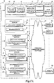
- FIGURE 1A illustrates an exemplary overall environment for implementing a mobile image service, which includes a mobile image system 10 including various servers (a database server 11, a Yellow Pages server 12, a navigation server 13, a shopping assistance server 14, and a recommendations server 16) for supporting the mobile image service and one or more mobile devices 20a, 20b, and 20c (collectively referred to as "the mobile devices 20").
- the mobile image system 10 resides on a network, such as the Internet, and the mobile image system 10 and the mobile devices 20 are connected with each other via any suitable wireless communications network 22, such as an Internet-enabled wireless communications network that provides the mobile devices 20 with wireless access to the mobile image service available from the mobile image system 10.
- the wireless communications network 22 utilizes any one of a variety of wireless communications mediums and/or communication methods to transfer data.
- suitable wireless communications mediums/methods include, but are not limited to, wireless telephony, personal communications service (PCS), short message service (SMS), wireless application protocol (WAP), IEEE 802.XX wireless LAN (WLAN) including a Wireless-Fidelity (Wi-Fi) and Wi-Max networks, two-way paging networks, specialized mobile radio systems, non-licensed personal area network (PAN) technology, such as the Bluetooth protocol, and infrared links.
- the wireless communications network 22 may employ Internet Protocol (IP) addressing.
- IP Internet Protocol
- the mobile devices 20 can be any devices that communicate with the chosen wireless communications network 22, such as cellular phones, personal digital assistants (PDAs), mobile computer communicators, such as Blackberry® devices, etc., to be fully described in reference to FIGURE IB below.
- the wireless communications network 22 may also include a network that is in part a wired network.
- the servers 11, 12, 13, 14, and 16 of the mobile image system 10 may be interconnected on a wired network with which the mobile devices 20 interface wirelessly.
- the mobile devices 20 communicate with the mobile image system 10 via the wireless communications network 22 using IP addressing. Protocols and components for communicating wirelessly to and from the Internet are well known to those of ordinary skill in the art of computer network communications.
- each of the mobile devices 20 may execute any suitable user interface (UI) application (not shown) that understands given protocols for communicating with the mobile image system 10 via the network 22.
- UI applications include, but are not limited to, a Web browser application, .NETTM application, JAVA® application, such as J2EE® application, Pocket OutlookTM application, any custom-designed standalone UI application, etc.
- Each of these UI applications permits a user of the mobile device 20 to download, upload, display, or otherwise access resources and services available from the mobile image system 10 and, in particular, provides the user with a graphical user interface (GUI) to the mobile image system 10.
- GUI graphical user interface
- the mobile image system 10 as depicted in FIGURE 1A operates in a distributed computing environment comprising several computer systems that are interconnected by communication links, e.g., using one or more computer networks or direct connections.
- communication links e.g., using one or more computer networks or direct connections.
- the system 10 could equally operate in a computer system having fewer or greater number of components than are illustrated in FIGURE 1A .
- each of the servers depicted in FIGURE 1A may be implemented using a greater number of computing systems so that each of the various services (collectively referred to as the "mobile image service") provided by the mobile image system 10 may be performed by a cluster of different computing devices.
- the mobile image system 10 and the mobile device 20 may be reduced to a single computer system (i.e., embedded in the mobile device 20), as will be more fully described below. Therefore, the description of the mobile image system 10 in FIGURE 1A should be taken as exemplary, and not limiting the scope of the invention.
- the illustrated embodiment of the mobile image system 10 includes a database server 11, a Yellow Pages server 12, a navigation server 13, a shopping assistance server 14, and a recommendations server 16.
- the database server 11 includes various databases, such as an images database 40, listings database 42, maps-and-directions database 44, shopping database 45, and user profiles database 46. These databases contain various data to be used by the servers of the mobile image system 10, as will be fully described below.
- the Yellow Pages server 12 includes an operating system 24 and a search engine 26.
- the details of the Yellow Pages server 12, together with construction of the images database 40 and the listing database 42, are described in U.S. Patent Application No. 10/809,049 , incorporated above.
- the Yellow Pages server 12 is a Web page server that supports an online Yellow Pages Web site, at which each listing (e.g., business) can be displayed together with an image of the listing (e.g., an image of the business storefront).
- the Yellow Pages server 12 communicates text and graphics organized as a Web page using, for example, hypertext transfer protocols, in response to requests and search queries received from any of the mobile devices 20.
- the listings and their associated location-specific images, which are processed by the Yellow pages server 12, are stored in the listings database 42 and the images database 40, respectively, within the database server 11, in accordance with one embodiment of the present invention. It should be understood by those skilled in the art that a particular configuration of the databases is not limited to what is disclosed in FIGURE 1A , and the databases shown to be included in the database server 11 may be arranged in a distributed manner or may be consolidated into a fewer number of databases, etc.
- the listings database 42 stores information generally found in conventional Yellow Pages in a searchable form, e.g., listings (business names together with their addresses, phone numbers, etc.) searchable by their business names, addresses, phone numbers, business types, etc.
- the listings database 42 may further store each listing in association with its geographic coordinates (e.g., longitude/latitude coordinates).
- geographic coordinates refer to various types of geographic identifiers used in suitable position-identification systems, including the two axes-based global coordinates system (i.e., longitude/latitude coordinates), a two axes-based local or customized coordinates system, or any other addressing system that uniquely identifies a geographic location.
- the images database 40 contains digitized images of the business listings taken at their geographic locations in association with their geographic coordinates. Thus, between the images database 40 and the listings database 42, each image is associated with its geographic coordinates and is further correlated with its street address. A combination of the images database 40 and the listings database 42 is therefore referred to as an image-address database 43.
- the Yellow Pages Server 12 In operation, upon receiving a search request from users of the mobile devices 20, the Yellow Pages Server 12 conducts a searches of the listings database 42 and the images database 40, and identifies and transmits appropriate listings together with their images over the network 22 to the requesting mobile devices 20 for display.
- the administration and overall operation of the Yellow Pages server 12 is controlled by its operating systems 24, while its search function is performed by the search engine 26 in cooperation with the image-address database 43.
- the image-address database 43 is configured to receive search instructions from the search engine 26 and to return search results thereto.
- the Yellow Pages server 12 and the image-address database 43 will each typically employ a memory and main processor in which program instructions are stored and executed for their operation.
- the Yellow Pages server 12 and the image-address database 43 permit users of the mobile devices 20 to search and view online Yellow Pages in which each listing (e.g., business) is displayed with an image of an object (e.g., business building) taken at its geographic location. Since each image is correlated with its street address in the image-address database 43, the users can search for and view an image of a business based on its street address (or based on any other data associated with the business listing in the listings database 42).
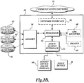
- FIGURE 1B illustrates an exemplary configuration of a mobile device 20 suitable for use in the present invention.
- a mobile device 20 may be any device that communicates with a chosen wireless communications network 22, such as cellular phones, personal digital assistants (PDAs), mobile computer communicators, such as Blackberry® devices, portable (mobile) computers, such as laptop computers, Webpads, tablets, and other computing devices having some type of memory, etc.
- the mobile device 20 includes a processor 50 in communication with an input/output interface 52, a memory 54, and a network interface 56 for interfacing with the wireless communications network 22.
- the input/output interface 52 enables the processor 50 to communicate with various input and output devices.
- Input devices 58 may include any computing elements that provide input signals to the processor 50, such as a keyboard, a mouse, a speech recognition application, such as Microsoft® Speech.NETTM application, etc.
- Output devices 60 may include typical output devices, in particular a screen display.
- the processor 50 is configured to operate in accordance with computer program instructions stored in a memory, such as the memory 54. Program instructions may also be embodied in the hardware format, such as one or more programmed digital signal processors.
- location-specific images are stored in the images database 40 of the mobile image system 10 (see FIGURE 1A ) and transmitted over the wireless communications network 22 to be received by the mobile device 20 for display on its screen 60.
- a set of location-specific images may be transmitted over the wireless communications network 22 to be pre-stored in the memory 54 (for example, a hard drive) of the mobile device 20, and the pre-stored images can then be retrieved and displayed on the screen 60.
- the wireless communications network 22 for example, a hard drive
- location-specific images may be pre-stored in a hard disk (including DVD, CD, etc.), such as in a Yellow Pages hard disk 62, a navigation hard disk 64, and a shopping assistance hard disk 66, and may be loaded onto the memory 54 of the mobile device 20.
- a hard disk including DVD, CD, etc.
- These hard disks are received by a disk drive (forming part of the memory 54) of the mobile device 20 for storage.
- the mobile device 20 may be a car navigation system without a wireless communications capability to which different sets of location-specific images in the form of different hard disks can be loaded depending on the particular general area of interest to the user. In this application, it is not necessary for the mobile device 20 to retrieve location-specific images from the images database 40 of the mobile image system 10 over the wireless communications network 22.
- the functionality provided by the mobile image system 10 is best described in terms of services.
- the present invention offers various mobile image services, in each of which a mobile device 20 displays a location-specific image that is selected based on the determined position of the mobile device 20.
- These services may be provided by the servers, each of which is depicted as a single computing device for ease of illustration in FIGURE 1A , or may be provided by a greater number of computing devices than shown in FIGURE 1A .
- any stand-alone server may be supported by multiple computer systems connected together by a local area network or other communication mechanism.
- the services may be provided by the mobile device 20 itself when it locally stores all necessary data and instructions (program code) in its memory device, as described above. Accordingly, it should be understood that the term "mobile image system” as used herein encompasses various hardware configurations for implementing the mobile image services of the present invention, and is not limited to the particular configuration depicted in FIGURE 1A .
- a location-specific image to be displayed on the screen 60 of the mobile device 20 is selected based on the position of the mobile device 20 as determined by a position identification system.
- the term "position identification system" is used to refer to any system that is capable of identifying the geographic position of the mobile device 20 so as to permit selection of location-specific images for display based on the determined position.
- the position identification system may utilize device-based technologies, i.e., technologies that permit the mobile device 20 to self-identify its position.
- An example of using such technologies is to equip the mobile device 20 with a global positioning system (GPS) receiver 68, as shown in FIGURE IB.
- GPS global positioning system
- the position identification system may utilize network-based technologies, wherein the position of the mobile device 20 is identified based on a communication link connecting the mobile device 20 and the mobile image system 10 over the wireless communications network 22 (see FIGURE 1A ).
- network-based technologies For example, certain cellular phone systems track the strength, the angle, and the arrival time difference of transmission signals for determining a cell phone's position, using time difference of arrival (TDOA) technology or timing advance (TA) location measurement technology.
- TDOA time difference of arrival
- TA timing advance
- the position of the mobile device 20 is identified by the overall wireless communications network 22, perhaps at its base station (not shown), and the identified position may be relayed to the mobile device 20 and/or the mobile image system 10 to select suitable location-specific images for display based on the identified position of the mobile device 20.
- the position identification system may utilize a combination of both device-based technologies and network-based technologies.
- the position identification system may be in compliance with the wireless Enhanced 911 standard prescribed by the United States Federal Communications Commission ("the wireless E911 standard").
- the wireless E911 standard mandates that cellular phone service providers within the United States provide the capability to locate the position of a cellular phone making an emergency (911) call within the provider's system.
- Other position identification systems may be in compliance with similar standards prescribed in other countries.
- a position identification system in accordance with the present invention is capable of identifying the position of the mobile device (e.g., a cellular phone) with respect to any "calls" placed to any numbers, IP addresses, etc., and is not limited to emergency calls.
- the mobile device e.g., a cellular phone
- the determination of the position of the mobile device 20 may or may not be performed by the mobile device 20 itself.
- a position identification system is such that the mobile device 20 is configured to self-identify its position (e.g., using a GPS receiver)
- the mobile device 20 is equipped with such a position identification system, and the position identification system, perhaps in conjunction with the processor 50 of the mobile device 20, will determine the position of the mobile device 20.
- the mobile device 20 (or, more specifically, its processor 50) will then carry out suitable instructions to select location-specific. images for display based on the determined position of the mobile . device 20.
- the position of the mobile device 20 may be determined by the overall wireless communications network 22 (e.g., using TDOA technology) without having the mobile device 20 perform any particular functions other than being turned on and transmitting/receiving signals to/from the network 22.
- the determined position of the mobile device 20 may or may not be relayed to the mobile device 20, and selection of suitable location-specific images based on the determined location of the mobile device 20 may be performed by the mobile device 20 and/or the mobile image system 10.
- FIGURE 1C illustrates two-way transfer of location-specific images between the images database 40 of the mobile image system 10 and the mobile device 20 over the wireless communications network 22.
- the processor 50 of the mobile device 20 may associate the captured image with the position of the mobile device 20 at the time the image was taken (as determined by any suitable position identification system, described above) to produce a location-specific image (i.e., an image associated with the geographic coordinates of the location at which the image was taken).
- the location-specific image can then be transmitted over the wireless communications network 22 to be included in the images database 40 within the mobile image system 10.
- the images database 40 can be constantly updated and/or expanded by receiving additional location-specific images uploaded from the mobile devices 20.
- a location-specific image associated with particular geographic coordinates is of poor quality (blurred, partially hidden by an obstructing object such as a passing pedestrian, etc.)
- a user of the mobile device 20 can take a high-quality image at the same location and upload the image to replace the poor-quality image.
- a user of the mobile device 20 can upload a location-specific image for the purpose of receiving a specific service.
- the user when a user is locked out of a car, house, etc., the user can take an image of his location including the car, house, etc, and send the location-specific image via the wireless communications network 22 to a locksmith whose computing device has a display.
- the location-specific image sent by the user will be displayed on the computing device of the locksmith, together with its associated address, so that the locksmith can readily determine and reach the location of the user.
- the mobile image system 10 may further include the navigation server 13, including an operating system 28 and a directions calculation module 30.
- the navigation server 13 generates a navigation program which, when executed on the mobile device 20, will display not only the relevant maps-and-directions to a destination location, but also various location-specific images of the destination location and any landmark points along the way.
- the administration and overall operation of the navigation server 13 is controlled by its operating system 28, while its function for calculating directions and generating a directions program is performed by the directions calculation module 30 in cooperation with the maps-and-directions database 44, the images database 40, and the listings database 42, for example.
- FIGURE 2 illustrates a sample routine 200 to be performed by the directions calculation module 30 to generate a navigation program that incorporates various location-specific images to be displayed on the mobile device.
- the directions calculation module 30 receives a request for a navigation service from a mobile device 20.
- the directions calculation module 30 further receives a desired destination location from the mobile device 20.
- the user of the mobile device 20 may type in the address or the business name of the destination location on the mobile device 20, and the information is received by the directions calculation module 30.
- the directions calculation module 30 identifies a location-specific image of the destination location. Specifically, for example, the module 30 may request the search engine 26 of the Yellow Pages server 12 to search through the listings database 42 to identify a particular listing corresponding to the destination location as entered by the user. Once a particular listing is identified, it may then be used to identify a location-specific image of the destination location as stored in the images database 40. The identified location-specific image is associated with the geographic coordinates of the location (i.e., the destination location in this case) at which the image was taken.
- the IP address may be used to determine a general geographic position of the mobile device 20 thereby selecting a subset of listings that generally correspond to the determined geographic position. For example, when the mobile devices 20 access the navigation server 13 and the image-address database 43 over the wireless communications network 22, it may be preferable to first limit a number of possible listings (and hence their corresponding location-specific images) to search through, especially when the data size contained in the image-address database 43 is large. Most IP addresses are associated with a server that is physically proximate to the locations of the IP address owners. Thus, based on an IP address of the mobile device 20, it is possible to estimate a general geographic position (e.g., city) of the mobile device 20. Then, only those listings corresponding to the general geographic position may be searched, at least initially, to find a listing corresponding to the destination location. Thereafter, a location-specific image corresponding to the listing can be found.
- a general geographic position e.g., city
- the directions calculation module 30 calculates directions from the current position of the mobile device, as determined by any suitable position identification system as described above, to the destination location in reference to the maps-and-directions database 44.
- Various methods of calculating directions are well known in the art.
- the directions calculation module 30 may then identify one or more landmark points along the calculated directions.
- any predefined points of interest such as major intersections, large buildings, parks, etc. can be designated as landmark points in the maps-and-directions database 44.
- the module 30 automatically selects one or more landmark points along the calculated directions according to any suitable algorithm.
- the module 30 may select landmark points at a certain interval.
- each of the landmark points may be pre-rated according to its importance (or preference), and only those landmark points above a certain preference level may be selected in each application, for example according to a user input.
- the geographic coordinates are found from the maps-and-directions database 44, and may then be used to find a location-specific image taken at the geographic coordinates from the images database 40.
- the directions calculation module 30 compiles a navigation program for displaying on the mobile device 20 an image of the destination location, in addition to the ordinary directions and maps for navigating the user to the destination location.
- the navigation program may be further configured to display images of one or more landmark points along the way to the destination location. Each of these images will be displayed based on the position of the mobile device 20 as determined by the position identification system (e.g., a GPS receiver). Additionally, in one application, the images of the landmark points and the destination location, or any portion thereof, may be stored and/or presented in the form of a video clip. In this application, essentially all locations along the way toward the destination location that are associated with location-specific images (or a portion thereof) are designated as landmark points, and their location-specific images are included in a video clip.
- the directions calculation module 30, together with its associated databases, such as the images database 40, the listings database 42, and the maps-and-directions database 44, may be contained in a hard disk 64 and stored in the memory 54 of the mobile device 20. (See FIGURE IB).
- the navigation service as described above may be made available to the mobile device 20 that may not necessarily interface with a wireless communications network 22.
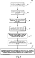
- FIGURE 3 is a flowchart illustrating actions taken when the navigation program generated in accordance with FIGURE 2 is executed.
- the navigation program is executed to display relevant directions and maps in a manner well known in the art. For example, a map of the relevant area may be displayed with an icon representative of the mobile device 20 moving on the map in accordance with the actual movement of the mobile device 20 as determined by the position identification system. Suitable directions in graphical and/or text form may also be displayed.
- FIGURE 8 illustrates a sample screen shot displaying a location-specific image 800 of a landmark point (an intersection in this example), together with suitable directions in both text 802 ("If you see this, turn right") and graphics (a left-turning arrow 804 in the example).
- the location-specific image 800 can remain displayed until the landmark point is passed. For example, the image 800 can be displayed until the distance between the landmark point and the mobile device 20 starts to increase.
- the navigation program resumes displaying ordinary maps-and-directions, while continuing to monitor to see if any other landmark point comes close to the mobile device 20 (block 302).
- the final destination location is nearing. This determination can be made, for example, when the final destination location comes within a certain distance from the current position of the mobile device 20 as determined by the position identification system. If so, then proceeding to block 308, the location-specific image of the final destination is displayed on the mobile device 20. An appropriate message, such as "Your destination looks like this," can be displayed at this time. The image may remain displayed until the user (i.e., the mobile device 20) reaches the destination location.
- FIGURE 3 illustrates merely one example of actions to be performed when a navigation program is executed, and accordingly, the navigation program in accordance with the present invention is not limited to the particular embodiment disclosed in FIGURE 3 .
- the image of the final destination may be displayed initially upon execution of the navigation program so that the user can view what to look for at his/her destination location prior to starting his/her journey.
- a video clip of a series of location-specific images along the way to a final destination (or a portion thereof) may be displayed initially upon execution of the navigation program so that the user can view the entire journey at the outset.
- an image of the final destination may be displayed on the mobile device 20 anytime a user's request for such an image is received.
- various other services may be provided with respect to each of the location-specific images to be displayed. For example, if a user is traveling to a final destination, such as a restaurant, the user may be permitted to make a reservation at the restaurant upon viewing the location-specific image of the restaurant using his/her mobile device 20. For example, many businesses have Wi-Fi devices which could process various requests, such as reservation requests, received via a wireless communications network 22 from the mobile device 20. As another example, if the final destination is a movie theater, the user of the mobile device 20 may be permitted to purchase movie tickets upon viewing the location-specific image of the movie theater wirelessly over the communications network 22.
- the mobile image system 10 may further include the shopping assistance server 14.
- the shopping assistance server 14, in conjunction with the shopping database 45, etc. allows a user of the mobile device 20 to view images of stores that carry items that the user wishes to purchase.
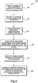
- FIGURE 4 illustrates a sample routine 400 for generating a shopping program in accordance with one embodiment of the present invention.
- the shopping assistance module 34 receives a request for a shopping assistance service from a user of the mobile device 20.
- the module 34 receives a shopping list from the user of the mobile device. For example, the user may enter text into his/her mobile device 20 to list items that the user wishes to purchase (stamps, milk, books, etc.).
- the module 34 finds a corresponding "store category” that carries such an item (e.g., "post offices” for stamps, "grocery stores” for milk, “book stores” for books, etc.) This can be determined based on a predefined look-up table, for example, as stored in the shopping database 45. Alternatively, the user may directly enter the store categories in the shopping list as opposed to the items to be purchased.
- a corresponding "store category” that carries such an item (e.g., "post offices” for stamps, "grocery stores” for milk, “book stores” for books, etc.) This can be determined based on a predefined look-up table, for example, as stored in the shopping database 45. Alternatively, the user may directly enter the store categories in the shopping list as opposed to the items to be purchased.
- the module 34 finds one or more stores listed under the store category and also find the geographic (e.g., longitude/latitude) coordinates of these stores. This can be done, for example, by referring to the listings database 42 included in the database server 11. Specifically, in accordance with various exemplary embodiments of the present invention, the listings database 42 lists various stores, businesses, etc., under each store category, together with their addresses, phone numbers, geographic longitude/latitude coordinates, business hours, etc. Therefore, for each of the store category, a list of stores together with their geographic coordinates can be obtained by searching through the listing database 42.
- the listings database 42 lists various stores, businesses, etc., under each store category, together with their addresses, phone numbers, geographic longitude/latitude coordinates, business hours, etc. Therefore, for each of the store category, a list of stores together with their geographic coordinates can be obtained by searching through the listing database 42.
- a location-specific image can be found. It should be apparent to one skilled in the art that it is not necessary to retrieve the location-specific images of these stores at this point, it is only necessary to be able to access these location-specific images based on their geographic coordinates and the determined position of the mobile device 20, as will be described below.
- the module 34 finally compiles a shopping program for displaying images of the stores that sell the items/products included in the shopping list. Each of these images will be displayed based on the position of the mobile device 20 as determined by the position identification system.
- the shopping assistance module 34 may be contained in a hard disk 66 and stored in the memory 54 of the mobile device 20 (see FIGURE IB).
- the shopping assistance service as described above may be made available to the mobile device 20 that may not necessarily interface with a wireless communications network 22.
- FIGURE 5 illustrates actions performed during execution of the shopping program generated in accordance with FIGURE 4 above.
- the program monitors for the occurrence of a decision event of block 502.
- the program alerts the user (for example, by issuing a beeping sound) and displays an image of the store on the mobile device 20 with an appropriate message.
- FIGURE 9 is a sample screen shot displaying an image 900 of the store that is coming close to the mobile device 20, together with a text message that reads "You can get your'_____' (902--insert the relevant item on the shopping list) at'_____' (904--insert the store name and address) near you.”
- directions to the store may further be calculated and displayed by utilizing the navigation server 13 discussed above.
- the image of the store 900 can be displayed until the user (or more specifically, the user's mobile device 20) reaches or passes the store. For example, this point of time can be determined when the distance from the mobile device to the store starts to increase.
- the items to be entered into a shopping list may be general, such as "books," or may be more specific, such as a particular title of a book.
- the mobile image system 10 of the present invention may be coupled via the wireless communications network 22 with searchable inventory databases of various bookstores. Then, a particular book title entered in a shopping list as received from the mobile device 20 of a user can be searched within these inventory databases to identify only those bookstores that actually carry this particular title. In this example, in FIGURE 4 , block 406, only those bookstores that carry this particular title, together with their geographic coordinates, are found. Thereafter, in block 408, a shopping program is compiled for displaying location-specific images of only those bookstores.
- the mobile image system 10 may further include the recommendations server 16.
- the recommendations server 16 includes an operating system 36 and a recommendations module 38.
- the recommendations server 16 in conjunction with the user profiles database 46, the image-address database 43, etc., may cause the mobile device 20 to display location-specific images of the user's "favorite" places. As before, these images will be displayed based on the determined position of the mobile device 20.
- Each user's "favorite" places are determined in reference to the data contained in the user profiles database 46. Specifically, for each user having a user ID, the user profiles database 46 stores his/her favorite places or information that can be used to determine his/her favorite places in association with his/her user ID.
- a user may actively (explicitly) enter his/her favorite places into the user profiles database 46, for example, by typing in the addresses of the favorite places.
- a user's favorite places may be presumed (determined) based on the user's observed behavior on the mobile image system 10. For example, when the user accesses the navigation service provided by the navigation server 13 and enters a certain destination location, the destination location may be presumed to be the user's favorite place and stored as such in the user's profile.
- the shopping assistance service provided by the shopping assistance server 14 and enters a shopping list including certain items, the stores that carry those items may be presumed to be the user's favorite places and added to the user's profile.
- a user's profile contains a list of the user's favorite books
- a list of geographic locations that appear in the book may be compiled (e.g., the name of a restaurant that a book's main character visits). Then, these geographic locations may be presumed to be the user's favorite places, and added to the user's profile in the database 46.
- general favorite places e.g., favorite places of other users
- each user of the mobile device 20 accessing the recommendations service has a user ID, and has an associated user profile included in the user profiles database 46 (although the amount and content of information included in each user profile may vary), which can be used to determine the user's favorite places.
- a user ID does not necessarily coincide with a device ID; in some applications one mobile device may be shared by multiple users each having his/her own user ID and a user profile.
- FIGURE 6 is a flow chart illustrating a sample routine 600 for generating a favorite places program in accordance with one embodiment of the present invention.
- the recommendations module 38 receives a request for a recommendations service from the mobile device 20.
- the module 38 forms a list of the favorite places of the user requesting the recommendations service.
- the module 38 refers to the user profiles database 46 and retrieves the user's favorite places stored in the user's profile and/or determines the user's favorite places based on the information contained in the user's profile.
- the module 38 finds geographic coordinates for each of the user's favorite places, in reference to the image-address database 43.
- the module 38 compiles a favorite places program for displaying location-specific images of the favorite places when the user is near or at these favorite places, based on the determined position of the mobile device 20.
- FIGURE 7 is a flowchart illustrating actions taken during execution of the favorite places program generated in accordance with FIGURE 6 .
- the program monitors for the occurrence of a decision event of block 702.
- it is determined whether any of the favorite places is nearing For example, this determination can be made when the determined position of the mobile device 20 comes within a certain distance from the longitude/latitude coordinates of any of the favorite places. If so, at block 704, the program alerts the user (e.g., by issuing a beep sound), and displays an image of the favorite place on the mobile device 20 together with an appropriate message.
- FIGURE 10 is a sample screen shot displaying an image 1000 of a favorite place (a library in this example) that is coming close to the mobile device 20, together with a text message that reads "Your favorite '________' (1002--insert the place name, for example "library”) is near you at '____________' (1004--insert the place address)."
- directions to the favorite place may further be calculated and displayed by utilizing the navigation server 13 discussed above.
- the image of the favorite place can remain displayed until the user (or more specifically, the user's mobile device 20) reaches or passes the favorite place.
- a location-specific image selected for a user based on his/her user ID may be supplemented with further information available from his/her user profile. For example, when an image of a place that the user has visited in the past is selected based on his/her user profile, the date on which the user last visited the place may be obtained and used to calculate the period of time that has passed since that time.
- the image can be displayed on the user's mobile device together with a message such as "It's been '__' months/years since you last visited your favorite '_______' (insert the place name, address, etc.)."
- Other types of supplemental information to annotate a selected image include, for example, a list of items that the user has purchased at a place in the image, or a title of a book in which a place in the image appears together with any rating that the user has given to the book.
- the present invention provides methods and systems that permit a user of a mobile device to view location-specific images in various situations, for example when trying to reach a certain destination location or to purchase items on a shopping list.
- the methods and systems display location-specific images based on the determined position of the mobile device so that the location-specific images are displayed in a timely and geographically relevant manner to assist the user in finding and reaching the desirable locations.
Landscapes
- Engineering & Computer Science (AREA)
- Radar, Positioning & Navigation (AREA)
- Remote Sensing (AREA)
- General Physics & Mathematics (AREA)
- Physics & Mathematics (AREA)
- Theoretical Computer Science (AREA)
- Business, Economics & Management (AREA)
- Databases & Information Systems (AREA)
- Automation & Control Theory (AREA)
- Computer Networks & Wireless Communication (AREA)
- Signal Processing (AREA)
- Accounting & Taxation (AREA)
- Finance (AREA)
- General Engineering & Computer Science (AREA)
- Data Mining & Analysis (AREA)
- General Business, Economics & Management (AREA)
- Strategic Management (AREA)
- Marketing (AREA)
- Economics (AREA)
- Development Economics (AREA)
- Computational Linguistics (AREA)
- Multimedia (AREA)
- Human Computer Interaction (AREA)
- Environmental & Geological Engineering (AREA)
- Health & Medical Sciences (AREA)
- Audiology, Speech & Language Pathology (AREA)
- General Health & Medical Sciences (AREA)
- Computer Hardware Design (AREA)
- Navigation (AREA)
- Information Retrieval, Db Structures And Fs Structures Therefor (AREA)
- Mobile Radio Communication Systems (AREA)
Description
- The present invention is related to providing location-specific services to mobile devices, and more specifically, to displaying a location-specific image on a mobile device based on a determined position of the mobile device.
- Various types of mobile devices are available to transmit/receive various information wirelessly, such as cellular phones, personal digital assistants (PDAs), Blackberry® devices, etc. These devices can store and process an increasing amount of information, including real-time images in the form of a video clip. Many of these devices include a color screen that can display images (graphics) as well as text. Further, some of these devices are equipped with a global positioning system (GPS) receiver so as to function as a navigation system, in addition to functioning as a communications device. As is well known in the art, a navigation system can receive a destination location from a user, calculate suitable directions to go from the user's current position, as determined based on data obtained by the GPS receiver, to the destination location, and display the directions together with a relevant map on its screen. The directions and a map as displayed on the screen are constantly updated based on the current (moving) position of the user as determined based on data obtained by the GPS receiver. Current navigation systems, however, do not display a ground-level image of the destination location (i.e., an image taken at the destination location), or any other images of locations that the user will pass along the way toward the destination location. A ground-level image, as used herein, means an image that shows an object (e.g., a business storefront) in the manner actually perceived by people on the ground, as opposed to aerial or rooftop images. It would be helpful for the user to be able to view such images on the screen of the navigation system so that the user can look for particular objects (e.g., buildings, intersections, etc.) shown in the images of the destination location and any other landmark points along the directions, especially when traveling in an unfamiliar area. More particularly, what is lacking is a system and method for displaying location-specific images (i.e., ground-level images of objects taken at particular locations) on a mobile device, such as a cellular phone and a car navigation system, based on the determined position of the mobile device.
- The present invention provides methods and systems whereby a mobile device, such as a cellular phone or a car navigation system, may display location-specific images based on the position of the mobile device as determined by a position identification system, such as a GPS system. To that end, a database of location-specific images is provided, wherein each image is associated with the geographic coordinates (e.g., longitude/latitude coordinates) of the location at which the image was taken. In various exemplary embodiments of the present invention, each image associated with its geographic coordinates is further correlated with its street address (or its business name, for example) so that the image can be retrieved and displayed based on a user input of its street address (or business name, etc.) The construction and use of such a database are disclosed in detail in co-pending
U.S. Patent Application No. 10/809,049, filed March 24, 2004 - Thus, for example, a user of a car navigation system will be able to enter a destination location using its street address, and the method and system of the present invention will permit the car navigation system to display the image of the destination location and additional images of other landmark points along the way toward the destination location in addition to the usual maps-and-directions to the destination location. The timing at which each of these location-specific images is to be displayed will depend on the current position of the car navigation system as determined by its position identification system (e.g., GPS system). In one example, an image of a landmark point will be displayed when the car navigation system comes within a certain distance from the landmark point with an appropriate text message, such as "Look for this, and turn left at this." Likewise, an image of the final destination location may be displayed when the car navigation system comes within a certain distance from the destination location, or whenever the user requests to view such an image, with an appropriate text message, such as "Look for this at your destination." Timely display of these location-specific images will assist the user in following the directions and finding the final destination location easily. Further, the image of a destination location may be displayed at the beginning (prior to starting the user's journey to the destination location) so as to assist the user in deciding whether or not to go there (e.g., based on how appealing the image of the destination location looks to the user), remembering whether the user has been there before, etc.
- In one embodiment, the location-specific images are provided to a mobile device through a wireless communications network from a centralized database. In another embodiment, the location-specific images may be pre-stored in the mobile device via a hard disk (including DVD, CD, etc.).
- In one application, instead of discrete images, a video clip that displays a moving view of an entire trip or a part thereof can be downloaded (or pre-stored) and displayed on a mobile device.
- In a further application, the location-specific images (including video images) may be transferred not only from a centralized database to mobile devices, but also from the mobile devices to the database. For example, if a mobile device, such as a cellular phone, has an image capturing capability, the user of the mobile device can take an image at a particular position, and the image can be automatically coded with the geographic coordinates of the position of the mobile device when the image is taken as determined by the position identification system (e.g., GPS receiver), and then the geo-coded image can be transferred from the mobile device to the database so as to continuously update and/or expand the database.
- Generally, in accordance with various exemplary embodiments of the present invention, a system is provided for providing location-specific images to a mobile device for display. The system is generally comprised of three components: a mobile device having a screen, a position identification system (e.g., a GPS receiver) that determines the position of the mobile device, and a location-specific images database including images taken at various locations, wherein each image is associated with geographic coordinates of the location at which the image was taken. The position of the mobile device is identified by the mobile device position identification system, and a location-specific image is selected from the database based on the determined position of the mobile device and displayed on the screen of the mobile device. For example, the location-specific image is selected when the determined position of the mobile device comes within a certain distance from the geographic coordinates associated with the image.
- The system may be adapted to selectively display location-specific images on a mobile device in various contexts. For example, the system may be applied to provide shopping assistance to a user of the mobile device. In this application, the system receives at the mobile device a shopping list from the user including one or more items that the user wishes to purchase. For each of the items in the shopping list, the system identifies one or more businesses that carry the item. Then, for each of the one or more identified businesses, the system determines its geographic coordinates and further identifies its corresponding location-specific image. Finally, the system generates a shopping list program comprising instructions for displaying on the screen of the mobile device an image of one of the one or more identified businesses based on the determined position of the mobile device. For example, the system may display a location-specific image of a particular business that carries an item included in the user's shopping list when the business is determined to be within a certain distance from the determined position of the mobile device. An audio alarm may be issued when the image is displayed to further alert the user that the relevant business is near.
- As another example, the system may be applied to recommend "favorite" places to visit to a user of the mobile device. In this application, the system, upon receiving from the mobile device a user's request for a recommendations service, accesses a profile of the user of the mobile device in a user profiles database to identify one or more favorite places of the user. The favorite places may be those places that the user has previously explicitly entered as his/her favorites, or may be presumed based on the user's past behavior on the system, for example, destination locations that the user has previously entered in a navigation service. The system then determines geographic coordinates of the one or more favorite places. Finally, the system generates a favorite places program comprising instructions for displaying on the screen of the mobile device an image of any of the one or more favorite places based on the determined position of the mobile device. For example, the system may display a location-specific image of a particular favorite place of the user when the favorite place is determined to be within a certain distance from the determined position of the mobile device.
- In accordance with a further aspect, the present invention provides a method of displaying a location-specific image on a mobile device based on the position of the mobile device. The method generally includes three steps. First, a position of a mobile device is received. Second, a location-specific image is selected from multiple location-specific images based on the received position of the mobile device, wherein each location-specific image is associated with geographic coordinates of the location at which the image was taken. Third, the selected image is displayed on the mobile device.
- In accordance with a still further aspect, the present invention provides a mobile device capable of displaying a location-specific image based on a determined position of the mobile device. The mobile device generally consists of two elements: a screen and a processor. The processor is loaded with processor-executable instructions for generally performing three steps. The first step involves receiving a position of the mobile device as determined by a position identification system. The second step involves selecting a location-specific image from a set of location specific images based on the determined position of the mobile device. The third step involves displaying the selected location-specific image on the screen. In an application wherein the set of images is stored in an images database external to the mobile device, a location-specific image is selected from the database based on the determined position of the mobile device, and is transmitted over a wireless communications network to the mobile device for display. In another application wherein the set of images is stored in a memory of the mobile device, a location specific image is selected from the memory based on the determined position of the mobile device and displayed on the screen.
- The foregoing aspects and many of the attendant advantages of this invention will become more readily appreciated as the same become better understood by reference to the following detailed description, when taken in conjunction with the accompanying drawings, wherein:
-
FIGURE 1A is a block diagram showing an environment and arrangement of certain computing components for implementing a mobile image service according to one embodiment of the present invention; - FIGURE IB is a diagram illustrating an exemplary configuration of a mobile device, suitable for use in receiving the mobile image service in accordance with one embodiment of the present invention;
-
FIGURE 1C is a pictorial diagram illustrating two-way transfer of location-specific images between an images database and one or more mobile devices through a network as implemented in various exemplary embodiments of the present invention; -
FIGURE 2 is a flow diagram of one exemplary method for generating a navigation program which upon execution will display one or more location-specific images based on the determined position of a mobile device according to one embodiment of the present invention; -
FIGURE 3 is a flow diagram illustrating the execution of the navigation program generated in accordance withFIGURE 2 above according to one embodiment of the present invention; -
FIGURE 4 is a flow diagram of one exemplary method of generating a shopping program which, upon execution, will display one or more location-specific images based on the determined position of a mobile device according to one embodiment of the present invention; -
FIGURE 5 is a flow diagram illustrating the execution of the shopping program generated in accordance withFIGURE 4 above according to one embodiment of the present invention; -
FIGURE 6 is a flow diagram of one exemplary method of generating a favorite places program which, upon execution, will display one or more location-specific images based on the determined position of a mobile device according to one embodiment of the present invention; -
FIGURE 7 is a flow diagram illustrating the execution of the favorite places program generated in accordance withFIGURE 6 above according to one embodiment of the present invention; -
FIGURE 8 is a sample screen shot that can be displayed on a mobile device during the execution of a navigation program in accordance with one embodiment of the present invention; -
FIGURE 9 is a sample screen shot that can be displayed on a mobile device during the execution of a shopping program in accordance with one embodiment of the present invention; and -
FIGURE 10 is a sample screen shot that can be displayed on a mobile device during the execution of a favorite places program in accordance with one embodiment of the present invention. - The present invention is directed to a system and method for providing a mobile image service. The mobile image service, as used herein, refers to one or more services that provide and display location-specific images on a mobile device based on the determined position of the mobile device. A location-specific image, as used herein, refers to an image taken at a location, and is thus associated with the geographic coordinates (e.g., longitude/latitude coordinates) of the location at which the image was taken. In various exemplary embodiments, location-specific images are ground-level location-specific images that show objects as generally perceived by people on the ground, as opposed to aerial or rooftop images. The following detailed description provides several exemplary implementations of the mobile image service. Although specific system configurations and flow diagrams are illustrated, it should be understood that the examples provided are not exhaustive and do not limit the invention to the precise forms disclosed. Persons having ordinary skill in the field of digital data processing will recognize that the computer components and the arrangements described herein may be interchangeable with other components and arrangements, and further that the process steps described herein may be interchangeable with other steps or combinations thereof and still achieve the benefits and advantages of the present invention.
-
FIGURE 1A illustrates an exemplary overall environment for implementing a mobile image service, which includes amobile image system 10 including various servers (adatabase server 11, aYellow Pages server 12, anavigation server 13, ashopping assistance server 14, and a recommendations server 16) for supporting the mobile image service and one or moremobile devices mobile devices 20"). Themobile image system 10 resides on a network, such as the Internet, and themobile image system 10 and themobile devices 20 are connected with each other via any suitablewireless communications network 22, such as an Internet-enabled wireless communications network that provides themobile devices 20 with wireless access to the mobile image service available from themobile image system 10. - The
wireless communications network 22 utilizes any one of a variety of wireless communications mediums and/or communication methods to transfer data. Examples of suitable wireless communications mediums/methods include, but are not limited to, wireless telephony, personal communications service (PCS), short message service (SMS), wireless application protocol (WAP), IEEE 802.XX wireless LAN (WLAN) including a Wireless-Fidelity (Wi-Fi) and Wi-Max networks, two-way paging networks, specialized mobile radio systems, non-licensed personal area network (PAN) technology, such as the Bluetooth protocol, and infrared links. Further, thewireless communications network 22 may employ Internet Protocol (IP) addressing. Accordingly, themobile devices 20 can be any devices that communicate with the chosenwireless communications network 22, such as cellular phones, personal digital assistants (PDAs), mobile computer communicators, such as Blackberry® devices, etc., to be fully described in reference to FIGURE IB below. Thewireless communications network 22 may also include a network that is in part a wired network. For example, theservers mobile image system 10 may be interconnected on a wired network with which themobile devices 20 interface wirelessly. - In one embodiment, the
mobile devices 20 communicate with themobile image system 10 via thewireless communications network 22 using IP addressing. Protocols and components for communicating wirelessly to and from the Internet are well known to those of ordinary skill in the art of computer network communications. Generally, each of themobile devices 20 may execute any suitable user interface (UI) application (not shown) that understands given protocols for communicating with themobile image system 10 via thenetwork 22. Examples of suitable UI applications include, but are not limited to, a Web browser application, .NET™ application, JAVA® application, such as J2EE® application, Pocket Outlook™ application, any custom-designed standalone UI application, etc. Each of these UI applications permits a user of themobile device 20 to download, upload, display, or otherwise access resources and services available from themobile image system 10 and, in particular, provides the user with a graphical user interface (GUI) to themobile image system 10. Themobile image system 10 as depicted inFIGURE 1A operates in a distributed computing environment comprising several computer systems that are interconnected by communication links, e.g., using one or more computer networks or direct connections. However, it will be appreciated by those of ordinary skill in the art that thesystem 10 could equally operate in a computer system having fewer or greater number of components than are illustrated inFIGURE 1A . For example, each of the servers depicted inFIGURE 1A may be implemented using a greater number of computing systems so that each of the various services (collectively referred to as the "mobile image service") provided by themobile image system 10 may be performed by a cluster of different computing devices. As another example, components of themobile image system 10 and themobile device 20 may be reduced to a single computer system (i.e., embedded in the mobile device 20), as will be more fully described below. Therefore, the description of themobile image system 10 inFIGURE 1A should be taken as exemplary, and not limiting the scope of the invention. - The illustrated embodiment of the
mobile image system 10 includes adatabase server 11, aYellow Pages server 12, anavigation server 13, ashopping assistance server 14, and arecommendations server 16. Thedatabase server 11 includes various databases, such as animages database 40, listings database 42, maps-and-directions database 44,shopping database 45, anduser profiles database 46. These databases contain various data to be used by the servers of themobile image system 10, as will be fully described below. - The
Yellow Pages server 12 includes anoperating system 24 and asearch engine 26. The details of theYellow Pages server 12, together with construction of theimages database 40 and the listing database 42, are described inU.S. Patent Application No. 10/809,049 , incorporated above. Briefly, theYellow Pages server 12 is a Web page server that supports an online Yellow Pages Web site, at which each listing (e.g., business) can be displayed together with an image of the listing (e.g., an image of the business storefront). TheYellow Pages server 12 communicates text and graphics organized as a Web page using, for example, hypertext transfer protocols, in response to requests and search queries received from any of themobile devices 20. It should be noted that while the present description is provided in the context of an online business directory (e.g., Yellow Pages) at which each business listing is associated with an image of its geographic location, the same concept can be applied to create and publish online residential directories (e.g., White Pages) in which each individual listing is associated with an image of its geographic location (e.g., an image of a house). Therefore, the term "Yellow Pages" as used herein may refer to other types of directories as well, including White Pages. - The listings and their associated location-specific images, which are processed by the Yellow pages
server 12, are stored in the listings database 42 and theimages database 40, respectively, within thedatabase server 11, in accordance with one embodiment of the present invention. It should be understood by those skilled in the art that a particular configuration of the databases is not limited to what is disclosed inFIGURE 1A , and the databases shown to be included in thedatabase server 11 may be arranged in a distributed manner or may be consolidated into a fewer number of databases, etc. The listings database 42 stores information generally found in conventional Yellow Pages in a searchable form, e.g., listings (business names together with their addresses, phone numbers, etc.) searchable by their business names, addresses, phone numbers, business types, etc. The listings database 42 may further store each listing in association with its geographic coordinates (e.g., longitude/latitude coordinates). As used herein, geographic coordinates refer to various types of geographic identifiers used in suitable position-identification systems, including the two axes-based global coordinates system (i.e., longitude/latitude coordinates), a two axes-based local or customized coordinates system, or any other addressing system that uniquely identifies a geographic location. Theimages database 40 contains digitized images of the business listings taken at their geographic locations in association with their geographic coordinates. Thus, between theimages database 40 and the listings database 42, each image is associated with its geographic coordinates and is further correlated with its street address. A combination of theimages database 40 and the listings database 42 is therefore referred to as an image-address database 43. - In operation, upon receiving a search request from users of the
mobile devices 20, theYellow Pages Server 12 conducts a searches of the listings database 42 and theimages database 40, and identifies and transmits appropriate listings together with their images over thenetwork 22 to the requestingmobile devices 20 for display. The administration and overall operation of theYellow Pages server 12 is controlled by itsoperating systems 24, while its search function is performed by thesearch engine 26 in cooperation with the image-address database 43. The image-address database 43 is configured to receive search instructions from thesearch engine 26 and to return search results thereto. Those of ordinary skill in the art will recognize that theYellow Pages server 12 and the image-address database 43 will each typically employ a memory and main processor in which program instructions are stored and executed for their operation. In combination, theYellow Pages server 12 and the image-address database 43 permit users of themobile devices 20 to search and view online Yellow Pages in which each listing (e.g., business) is displayed with an image of an object (e.g., business building) taken at its geographic location. Since each image is correlated with its street address in the image-address database 43, the users can search for and view an image of a business based on its street address (or based on any other data associated with the business listing in the listings database 42). -
FIGURE 1B illustrates an exemplary configuration of amobile device 20 suitable for use in the present invention. In various exemplary embodiments of the present invention, amobile device 20 may be any device that communicates with a chosenwireless communications network 22, such as cellular phones, personal digital assistants (PDAs), mobile computer communicators, such as Blackberry® devices, portable (mobile) computers, such as laptop computers, Webpads, tablets, and other computing devices having some type of memory, etc. In the illustrated embodiment, themobile device 20 includes aprocessor 50 in communication with an input/output interface 52, amemory 54, and anetwork interface 56 for interfacing with thewireless communications network 22. The input/output interface 52 enables theprocessor 50 to communicate with various input and output devices.Input devices 58 may include any computing elements that provide input signals to theprocessor 50, such as a keyboard, a mouse, a speech recognition application, such as Microsoft® Speech.NET™ application, etc.Output devices 60 may include typical output devices, in particular a screen display. Theprocessor 50 is configured to operate in accordance with computer program instructions stored in a memory, such as thememory 54. Program instructions may also be embodied in the hardware format, such as one or more programmed digital signal processors. In one application, location-specific images are stored in theimages database 40 of the mobile image system 10 (seeFIGURE 1A ) and transmitted over thewireless communications network 22 to be received by themobile device 20 for display on itsscreen 60. In another application, a set of location-specific images, for example, a set of location-specific images corresponding to the general area of interest to the user, may be transmitted over thewireless communications network 22 to be pre-stored in the memory 54 (for example, a hard drive) of themobile device 20, and the pre-stored images can then be retrieved and displayed on thescreen 60. - In a further application, location-specific images may be pre-stored in a hard disk (including DVD, CD, etc.), such as in a Yellow Pages
hard disk 62, a navigationhard disk 64, and a shopping assistancehard disk 66, and may be loaded onto thememory 54 of themobile device 20. Essentially, the images to be displayed on themobile device 20, together with their associated computer instructions, for use in providing the Yellow Pages service, the navigation service, and the shopping assistance service, respectively, may be stored in these disks. These hard disks are received by a disk drive (forming part of the memory 54) of themobile device 20 for storage. For example, themobile device 20 may be a car navigation system without a wireless communications capability to which different sets of location-specific images in the form of different hard disks can be loaded depending on the particular general area of interest to the user. In this application, it is not necessary for themobile device 20 to retrieve location-specific images from theimages database 40 of themobile image system 10 over thewireless communications network 22. - In various exemplary embodiments of the present invention, the functionality provided by the
mobile image system 10 is best described in terms of services. The present invention offers various mobile image services, in each of which amobile device 20 displays a location-specific image that is selected based on the determined position of themobile device 20. These services may be provided by the servers, each of which is depicted as a single computing device for ease of illustration inFIGURE 1A , or may be provided by a greater number of computing devices than shown inFIGURE 1A . As known to those skilled in the art, any stand-alone server may be supported by multiple computer systems connected together by a local area network or other communication mechanism. As another example, the services may be provided by themobile device 20 itself when it locally stores all necessary data and instructions (program code) in its memory device, as described above. Accordingly, it should be understood that the term "mobile image system" as used herein encompasses various hardware configurations for implementing the mobile image services of the present invention, and is not limited to the particular configuration depicted inFIGURE 1A . - In accordance with the present invention, a location-specific image to be displayed on the
screen 60 of themobile device 20 is selected based on the position of themobile device 20 as determined by a position identification system. In the present description, the term "position identification system" is used to refer to any system that is capable of identifying the geographic position of themobile device 20 so as to permit selection of location-specific images for display based on the determined position. The position identification system may utilize device-based technologies, i.e., technologies that permit themobile device 20 to self-identify its position. An example of using such technologies is to equip themobile device 20 with a global positioning system (GPS)receiver 68, as shown in FIGURE IB. Alternatively, the position identification system may utilize network-based technologies, wherein the position of themobile device 20 is identified based on a communication link connecting themobile device 20 and themobile image system 10 over the wireless communications network 22 (seeFIGURE 1A ). For example, certain cellular phone systems track the strength, the angle, and the arrival time difference of transmission signals for determining a cell phone's position, using time difference of arrival (TDOA) technology or timing advance (TA) location measurement technology. In this embodiment, the position of themobile device 20 is identified by the overallwireless communications network 22, perhaps at its base station (not shown), and the identified position may be relayed to themobile device 20 and/or themobile image system 10 to select suitable location-specific images for display based on the identified position of themobile device 20. Further alternatively, the position identification system may utilize a combination of both device-based technologies and network-based technologies. - A variety of position identification systems, utilizing device-based technologies and/or network-based technologies, are under development and/or available, as is well known in the art. When the
mobile device 20 consists of a cellular phone, the position identification system may be in compliance with the wireless Enhanced 911 standard prescribed by the United States Federal Communications Commission ("the wireless E911 standard"). The wireless E911 standard mandates that cellular phone service providers within the United States provide the capability to locate the position of a cellular phone making an emergency (911) call within the provider's system. Other position identification systems may be in compliance with similar standards prescribed in other countries. It should be noted that a position identification system in accordance with the present invention is capable of identifying the position of the mobile device (e.g., a cellular phone) with respect to any "calls" placed to any numbers, IP addresses, etc., and is not limited to emergency calls. - Therefore, the determination of the position of the
mobile device 20 may or may not be performed by themobile device 20 itself. Specifically, if a particular embodiment of a position identification system is such that themobile device 20 is configured to self-identify its position (e.g., using a GPS receiver), then themobile device 20 is equipped with such a position identification system, and the position identification system, perhaps in conjunction with theprocessor 50 of themobile device 20, will determine the position of themobile device 20. The mobile device 20 (or, more specifically, its processor 50) will then carry out suitable instructions to select location-specific. images for display based on the determined position of the mobile .device 20. On the other hand, in another embodiment of the position identification system, the position of themobile device 20 may be determined by the overall wireless communications network 22 (e.g., using TDOA technology) without having themobile device 20 perform any particular functions other than being turned on and transmitting/receiving signals to/from thenetwork 22. In such a case, the determined position of themobile device 20 may or may not be relayed to themobile device 20, and selection of suitable location-specific images based on the determined location of themobile device 20 may be performed by themobile device 20 and/or themobile image system 10. - Those having ordinary skill in the art of computers will recognize that a wide selection of commercially available components and arrangements can be used to construct a system, such as the
mobile device system 20 illustrated inFIGURE 1B . -
FIGURE 1C illustrates two-way transfer of location-specific images between theimages database 40 of themobile image system 10 and themobile device 20 over thewireless communications network 22. When themobile device 20 has an image capturing capability (e.g., including adigital camera 69 as shown in FIGURE IB), theprocessor 50 of themobile device 20 may associate the captured image with the position of themobile device 20 at the time the image was taken (as determined by any suitable position identification system, described above) to produce a location-specific image (i.e., an image associated with the geographic coordinates of the location at which the image was taken). The location-specific image can then be transmitted over thewireless communications network 22 to be included in theimages database 40 within themobile image system 10. Thus, theimages database 40 can be constantly updated and/or expanded by receiving additional location-specific images uploaded from themobile devices 20. For example, when a location-specific image associated with particular geographic coordinates is of poor quality (blurred, partially hidden by an obstructing object such as a passing pedestrian, etc.), a user of themobile device 20 can take a high-quality image at the same location and upload the image to replace the poor-quality image. As further examples, a user of themobile device 20 can upload a location-specific image for the purpose of receiving a specific service. As a specific example, when a user is locked out of a car, house, etc., the user can take an image of his location including the car, house, etc, and send the location-specific image via thewireless communications network 22 to a locksmith whose computing device has a display. The location-specific image sent by the user will be displayed on the computing device of the locksmith, together with its associated address, so that the locksmith can readily determine and reach the location of the user. - Referring back to
FIGURE 1A , themobile image system 10 may further include thenavigation server 13, including an operating system 28 and adirections calculation module 30. Thenavigation server 13, in conjunction with the image-address database 43 and the maps-and-directions database 44 in thedatabase server 11, provide and display location-specific images on themobile device 20 as part of a navigation program based on the determined position of themobile device 20. In particular, thenavigation server 13 generates a navigation program which, when executed on themobile device 20, will display not only the relevant maps-and-directions to a destination location, but also various location-specific images of the destination location and any landmark points along the way. The administration and overall operation of thenavigation server 13 is controlled by its operating system 28, while its function for calculating directions and generating a directions program is performed by thedirections calculation module 30 in cooperation with the maps-and-directions database 44, theimages database 40, and the listings database 42, for example. -
FIGURE 2 illustrates asample routine 200 to be performed by thedirections calculation module 30 to generate a navigation program that incorporates various location-specific images to be displayed on the mobile device. Atblock 201, thedirections calculation module 30 receives a request for a navigation service from amobile device 20. Atblock 202, thedirections calculation module 30 further receives a desired destination location from themobile device 20. For example, the user of themobile device 20 may type in the address or the business name of the destination location on themobile device 20, and the information is received by thedirections calculation module 30. - At
block 203, based on the received destination location, thedirections calculation module 30 identifies a location-specific image of the destination location. Specifically, for example, themodule 30 may request thesearch engine 26 of theYellow Pages server 12 to search through the listings database 42 to identify a particular listing corresponding to the destination location as entered by the user. Once a particular listing is identified, it may then be used to identify a location-specific image of the destination location as stored in theimages database 40. The identified location-specific image is associated with the geographic coordinates of the location (i.e., the destination location in this case) at which the image was taken. - In one application, when the
mobile device 20 is associated with an IP address, then the IP address may be used to determine a general geographic position of themobile device 20 thereby selecting a subset of listings that generally correspond to the determined geographic position. For example, when themobile devices 20 access thenavigation server 13 and the image-address database 43 over thewireless communications network 22, it may be preferable to first limit a number of possible listings (and hence their corresponding location-specific images) to search through, especially when the data size contained in the image-address database 43 is large. Most IP addresses are associated with a server that is physically proximate to the locations of the IP address owners. Thus, based on an IP address of themobile device 20, it is possible to estimate a general geographic position (e.g., city) of themobile device 20. Then, only those listings corresponding to the general geographic position may be searched, at least initially, to find a listing corresponding to the destination location. Thereafter, a location-specific image corresponding to the listing can be found. - At
block 204, thedirections calculation module 30 calculates directions from the current position of the mobile device, as determined by any suitable position identification system as described above, to the destination location in reference to the maps-and-directions database 44. Various methods of calculating directions are well known in the art. - Optionally, at
block 206, thedirections calculation module 30 may then identify one or more landmark points along the calculated directions. For example, any predefined points of interest, such as major intersections, large buildings, parks, etc. can be designated as landmark points in the maps-and-directions database 44. Themodule 30 automatically selects one or more landmark points along the calculated directions according to any suitable algorithm. For example, themodule 30 may select landmark points at a certain interval. As another example, each of the landmark points may be pre-rated according to its importance (or preference), and only those landmark points above a certain preference level may be selected in each application, for example according to a user input. - At
block 208, for each of the landmark points identified, the geographic coordinates are found from the maps-and-directions database 44, and may then be used to find a location-specific image taken at the geographic coordinates from theimages database 40. - At
block 210, thedirections calculation module 30 compiles a navigation program for displaying on themobile device 20 an image of the destination location, in addition to the ordinary directions and maps for navigating the user to the destination location. The navigation program may be further configured to display images of one or more landmark points along the way to the destination location. Each of these images will be displayed based on the position of themobile device 20 as determined by the position identification system (e.g., a GPS receiver). Additionally, in one application, the images of the landmark points and the destination location, or any portion thereof, may be stored and/or presented in the form of a video clip. In this application, essentially all locations along the way toward the destination location that are associated with location-specific images (or a portion thereof) are designated as landmark points, and their location-specific images are included in a video clip. - It should be understood that the
directions calculation module 30, together with its associated databases, such as theimages database 40, the listings database 42, and the maps-and-directions database 44, may be contained in ahard disk 64 and stored in thememory 54 of themobile device 20. (See FIGURE IB). Thus, essentially, the navigation service as described above may be made available to themobile device 20 that may not necessarily interface with awireless communications network 22. -
FIGURE 3 is a flowchart illustrating actions taken when the navigation program generated in accordance withFIGURE 2 is executed. Atblock 301, the navigation program is executed to display relevant directions and maps in a manner well known in the art. For example, a map of the relevant area may be displayed with an icon representative of themobile device 20 moving on the map in accordance with the actual movement of themobile device 20 as determined by the position identification system. Suitable directions in graphical and/or text form may also be displayed. - At
block 302, it is determined whether any landmark point is nearing. For example, this determination can be made if any of the landmark points comes within a certain distance from the current position of themobile device 20 as determined by the position identification system. If so, then atblock 304, the image of the landmark point that is nearing can be accessed and displayed on themobile device 20, with an appropriate message, such as "If you see this, turn right," etc.FIGURE 8 illustrates a sample screen shot displaying a location-specific image 800 of a landmark point (an intersection in this example), together with suitable directions in both text 802 ("If you see this, turn right") and graphics (a left-turningarrow 804 in the example). The location-specific image 800 can remain displayed until the landmark point is passed. For example, theimage 800 can be displayed until the distance between the landmark point and themobile device 20 starts to increase. - After the
mobile device 20 passes the landmark point, returning to block 301 (FIGURE 3 ), the navigation program resumes displaying ordinary maps-and-directions, while continuing to monitor to see if any other landmark point comes close to the mobile device 20 (block 302). - If, at
block 302, it is determined that no landmark point is near themobile device 20, then proceeding to block 306, it is determined whether the final destination location is nearing. This determination can be made, for example, when the final destination location comes within a certain distance from the current position of themobile device 20 as determined by the position identification system. If so, then proceeding to block 308, the location-specific image of the final destination is displayed on themobile device 20. An appropriate message, such as "Your destination looks like this," can be displayed at this time. The image may remain displayed until the user (i.e., the mobile device 20) reaches the destination location. - It should be emphasized that
FIGURE 3 illustrates merely one example of actions to be performed when a navigation program is executed, and accordingly, the navigation program in accordance with the present invention is not limited to the particular embodiment disclosed inFIGURE 3 . For example, the image of the final destination may be displayed initially upon execution of the navigation program so that the user can view what to look for at his/her destination location prior to starting his/her journey. As another example, a video clip of a series of location-specific images along the way to a final destination (or a portion thereof) may be displayed initially upon execution of the navigation program so that the user can view the entire journey at the outset. As a further example, an image of the final destination may be displayed on themobile device 20 anytime a user's request for such an image is received. - As further extensions of the present invention, various other services may be provided with respect to each of the location-specific images to be displayed. For example, if a user is traveling to a final destination, such as a restaurant, the user may be permitted to make a reservation at the restaurant upon viewing the location-specific image of the restaurant using his/her
mobile device 20. For example, many businesses have Wi-Fi devices which could process various requests, such as reservation requests, received via awireless communications network 22 from themobile device 20. As another example, if the final destination is a movie theater, the user of themobile device 20 may be permitted to purchase movie tickets upon viewing the location-specific image of the movie theater wirelessly over thecommunications network 22. - Referring back to
FIGURE 1A , themobile image system 10 may further include theshopping assistance server 14. Theshopping assistance server 14, as illustrated, includes anoperating system 32 and ashopping assistance module 34. Briefly, theshopping assistance server 14, in conjunction with theshopping database 45, etc., allows a user of themobile device 20 to view images of stores that carry items that the user wishes to purchase. - Specifically,
FIGURE 4 illustrates asample routine 400 for generating a shopping program in accordance with one embodiment of the present invention. Atblock 401, theshopping assistance module 34 receives a request for a shopping assistance service from a user of themobile device 20. Atblock 402, themodule 34 receives a shopping list from the user of the mobile device. For example, the user may enter text into his/hermobile device 20 to list items that the user wishes to purchase (stamps, milk, books, etc.). Atblock 404, for each of the items, themodule 34 finds a corresponding "store category" that carries such an item (e.g., "post offices" for stamps, "grocery stores" for milk, "book stores" for books, etc.) This can be determined based on a predefined look-up table, for example, as stored in theshopping database 45. Alternatively, the user may directly enter the store categories in the shopping list as opposed to the items to be purchased. - At
block 406, for each of the store categories entered or found, themodule 34 finds one or more stores listed under the store category and also find the geographic (e.g., longitude/latitude) coordinates of these stores. This can be done, for example, by referring to the listings database 42 included in thedatabase server 11. Specifically, in accordance with various exemplary embodiments of the present invention, the listings database 42 lists various stores, businesses, etc., under each store category, together with their addresses, phone numbers, geographic longitude/latitude coordinates, business hours, etc. Therefore, for each of the store category, a list of stores together with their geographic coordinates can be obtained by searching through the listing database 42. In one specific application, only those stores that are actually open (according to their business hours information) are returned based on the day and time at which the shopping list was received, as determined by an internal clock of themobile device 20 or a clock accessible by theshopping assistance server 14. Atblock 407, optionally, for each of the stores found, a location-specific image can be found. It should be apparent to one skilled in the art that it is not necessary to retrieve the location-specific images of these stores at this point, it is only necessary to be able to access these location-specific images based on their geographic coordinates and the determined position of themobile device 20, as will be described below. - At
block 408, themodule 34 finally compiles a shopping program for displaying images of the stores that sell the items/products included in the shopping list. Each of these images will be displayed based on the position of themobile device 20 as determined by the position identification system. - It should be understood that the
shopping assistance module 34, together with its associated databases, such as theshopping database 45,images database 40, and the listings database 42, etc., may be contained in ahard disk 66 and stored in thememory 54 of the mobile device 20 (see FIGURE IB). Thus, essentially, the shopping assistance service as described above may be made available to themobile device 20 that may not necessarily interface with awireless communications network 22. -
FIGURE 5 illustrates actions performed during execution of the shopping program generated in accordance withFIGURE 4 above. Atblock 501, the program monitors for the occurrence of a decision event ofblock 502. Atblock 502, it is determined whether any of the stores that may carry an item on the shopping list is nearing the position of themobile device 20 as determined by the position identification system. For example, this determination can be made if the longitude/latitude coordinates of any of these stores comes within a certain distance from the current position of themobile device 20. If so, proceeding to block 504, the program alerts the user (for example, by issuing a beeping sound) and displays an image of the store on themobile device 20 with an appropriate message.FIGURE 9 is a sample screen shot displaying animage 900 of the store that is coming close to themobile device 20, together with a text message that reads "You can get your'__________' (902--insert the relevant item on the shopping list) at'__________' (904--insert the store name and address) near you." In connection with the image of astore 900, directions to the store may further be calculated and displayed by utilizing thenavigation server 13 discussed above. The image of thestore 900 can be displayed until the user (or more specifically, the user's mobile device 20) reaches or passes the store. For example, this point of time can be determined when the distance from the mobile device to the store starts to increase. - The items to be entered into a shopping list may be general, such as "books," or may be more specific, such as a particular title of a book. In one example, the
mobile image system 10 of the present invention may be coupled via thewireless communications network 22 with searchable inventory databases of various bookstores. Then, a particular book title entered in a shopping list as received from themobile device 20 of a user can be searched within these inventory databases to identify only those bookstores that actually carry this particular title. In this example, inFIGURE 4 , block 406, only those bookstores that carry this particular title, together with their geographic coordinates, are found. Thereafter, inblock 408, a shopping program is compiled for displaying location-specific images of only those bookstores. - Referring again back to
FIGURE 1A , themobile image system 10 may further include therecommendations server 16. Therecommendations server 16, as illustrated, includes anoperating system 36 and arecommendations module 38. Therecommendations server 16, in conjunction with theuser profiles database 46, the image-address database 43, etc., may cause themobile device 20 to display location-specific images of the user's "favorite" places. As before, these images will be displayed based on the determined position of themobile device 20. Each user's "favorite" places are determined in reference to the data contained in theuser profiles database 46. Specifically, for each user having a user ID, theuser profiles database 46 stores his/her favorite places or information that can be used to determine his/her favorite places in association with his/her user ID. - A user may actively (explicitly) enter his/her favorite places into the
user profiles database 46, for example, by typing in the addresses of the favorite places. Alternatively, a user's favorite places may be presumed (determined) based on the user's observed behavior on themobile image system 10. For example, when the user accesses the navigation service provided by thenavigation server 13 and enters a certain destination location, the destination location may be presumed to be the user's favorite place and stored as such in the user's profile. Likewise, if the user accesses the shopping assistance service provided by theshopping assistance server 14 and enters a shopping list including certain items, the stores that carry those items may be presumed to be the user's favorite places and added to the user's profile. As another example, if a user's profile contains a list of the user's favorite books, for each of these books, a list of geographic locations that appear in the book may be compiled (e.g., the name of a restaurant that a book's main character visits). Then, these geographic locations may be presumed to be the user's favorite places, and added to the user's profile in thedatabase 46. Further alternatively, if no information is available regarding the preferences or past behavior of a particular user, general favorite places (e.g., favorite places of other users) may be presumed to be one of this user's favorite places also. Therefore, each user of themobile device 20 accessing the recommendations service has a user ID, and has an associated user profile included in the user profiles database 46 (although the amount and content of information included in each user profile may vary), which can be used to determine the user's favorite places. Note that a user ID does not necessarily coincide with a device ID; in some applications one mobile device may be shared by multiple users each having his/her own user ID and a user profile. -
FIGURE 6 is a flow chart illustrating a sample routine 600 for generating a favorite places program in accordance with one embodiment of the present invention. Atblock 601, therecommendations module 38 receives a request for a recommendations service from themobile device 20. Atblock 602, themodule 38 forms a list of the favorite places of the user requesting the recommendations service. To this end, themodule 38 refers to theuser profiles database 46 and retrieves the user's favorite places stored in the user's profile and/or determines the user's favorite places based on the information contained in the user's profile. Atblock 603, themodule 38 then finds geographic coordinates for each of the user's favorite places, in reference to the image-address database 43. Finally, atblock 604, themodule 38 compiles a favorite places program for displaying location-specific images of the favorite places when the user is near or at these favorite places, based on the determined position of themobile device 20. -
FIGURE 7 is a flowchart illustrating actions taken during execution of the favorite places program generated in accordance withFIGURE 6 . Atblock 701, the program monitors for the occurrence of a decision event ofblock 702. At thedecision block 702, it is determined whether any of the favorite places is nearing. For example, this determination can be made when the determined position of themobile device 20 comes within a certain distance from the longitude/latitude coordinates of any of the favorite places. If so, atblock 704, the program alerts the user (e.g., by issuing a beep sound), and displays an image of the favorite place on themobile device 20 together with an appropriate message. -
FIGURE 10 is a sample screen shot displaying animage 1000 of a favorite place (a library in this example) that is coming close to themobile device 20, together with a text message that reads "Your favorite '________' (1002--insert the place name, for example "library") is near you at '____________' (1004--insert the place address)." In connection with the image of thefavorite place 1000, directions to the favorite place may further be calculated and displayed by utilizing thenavigation server 13 discussed above. The image of the favorite place can remain displayed until the user (or more specifically, the user's mobile device 20) reaches or passes the favorite place. - In various applications of the present invention, a location-specific image selected for a user based on his/her user ID may be supplemented with further information available from his/her user profile. For example, when an image of a place that the user has visited in the past is selected based on his/her user profile, the date on which the user last visited the place may be obtained and used to calculate the period of time that has passed since that time. Then, the image can be displayed on the user's mobile device together with a message such as "It's been '__' months/years since you last visited your favorite '____________' (insert the place name, address, etc.)." Other types of supplemental information to annotate a selected image include, for example, a list of items that the user has purchased at a place in the image, or a title of a book in which a place in the image appears together with any rating that the user has given to the book.
- Accordingly, the present invention provides methods and systems that permit a user of a mobile device to view location-specific images in various situations, for example when trying to reach a certain destination location or to purchase items on a shopping list. In all of these situations, the methods and systems display location-specific images based on the determined position of the mobile device so that the location-specific images are displayed in a timely and geographically relevant manner to assist the user in finding and reaching the desirable locations.
Claims (16)
- A system for providing location-specific images to a mobile device for display, the mobile device (20) comprising a processor, memory, and screen;
the system comprising:a position identification system that determines the position of the mobile device; anda location-specific images database (40) including images taken at locations, each image being associated with geographic coordinates of the location at which the image was taken;wherein the position of the mobile device is identified by the mobile device position identification system, and a location-specific image is selected from the images database (40) based on the determined position of the mobile device and displayed on the screen of the mobile device
and further characterised in that:
the system comprises a shopping system that performs the steps comprising:receiving at the mobile device (20) a shopping list, the shopping list comprising one or more items that a user of the mobile device wishes to purchase;for each of the items in the list, identifying one or more businesses that carry the item that is open for business at a time of identification and is within a specified distance of the current position of the mobile device (20);for each of the one or more identified businesses, determining its geographic coordinates and identifying its location-specific image; andgenerating (400) a shopping list program comprising instructions for displaying on the screen of the mobile device an image of the one or more identified businesses based on the determined position of the mobile device, the at least one image including a ground-level view of an exterior of a building in which the at least one identified business resides. - The system of Claim 1, wherein the mobile device (20) is selected from the group consisting of a cellular phone, a PDA, a portable computer, a navigation system, and a mobile computer communicator.
- The system of Claim 1, wherein the position identification system utilizes a device-based technology to determine the position of the mobile device.
- The system of Claim 3, wherein the position identification system comprises a GPS receiver.
- The system of Claim 1, further comprising:
a wireless communications network, with which the mobile device interfaces; and in which the mobile image system interfaces with the wireless communications network. - The system of Claim 5, wherein the position identification system utilizes a network-based technology to determine the position of the mobile device based on a link between the mobile device and the mobile image system.
- The system of Claim 5, wherein the position identification system utilizes a device-based technology and a network-based technology.
- The system of Claim 5, wherein the mobile device (20) further comprises an image capturing subsystem (6a), and is capable of performing the steps comprising:capturing an image;associating the captured image with the determined position of the mobile device at the time when the image was captured so as to produce a location-specific image; andtransmitting the location-specific image over the wireless communications network to the location-specific images database in the mobile image system.
- The system of Claim 1, wherein the location-specific image is selected when the determined position of the mobile device comes within a certain distance from the geographic coordinates associated with the image.
- The system of Claim 1, wherein the system comprises a directions system (30) that performs the steps comprising:receiving at the mobile device (20) a destination location where a user of the mobile device wishes to go;calculating directions from the determined position of the mobile device to the destination location; andgenerating a directions program comprising the calculated directions to the destination location, the directions program further comprising instructions for displaying on the screen of the mobile device an image of the destination location based on the determined position of the mobile device.
- The system of Claim 10, wherein the image of the destination location is displayed when the determined position of the mobile device comes within a certain distance from the destination location.
- The system of Claim 10, wherein the directions program displays the image of the destination location on the screen of the mobile device upon a user request.
- The system of Claim 10, wherein the directions program further comprises instructions for displaying on the screen of the mobile device one or more images of landmark locations along the directions toward the destination location, the one or more images being displayed based on the determined position of the mobile device.
- The system of Claim 13, wherein the images of landmark locations are displayed as a video clip.
- The system of Claim 1, wherein the image of a business is displayed when the determined position of the mobile device (20) comes within a certain distance from the geographic coordinates of the business.
- The system of Claim 1, wherein the shopping list program further comprises instructions for issuing an audio signal to alert the user when the image of a business is displayed.
Applications Claiming Priority (2)
| Application Number | Priority Date | Filing Date | Title |
|---|---|---|---|
| US10/973,950 US8150617B2 (en) | 2004-10-25 | 2004-10-25 | System and method for displaying location-specific images on a mobile device |
| PCT/US2005/037737 WO2006047213A2 (en) | 2004-10-25 | 2005-10-20 | System and method for displaying location-specific images on a mobile device |
Publications (3)
| Publication Number | Publication Date |
|---|---|
| EP1805486A2 EP1805486A2 (en) | 2007-07-11 |
| EP1805486A4 EP1805486A4 (en) | 2011-08-31 |
| EP1805486B1 true EP1805486B1 (en) | 2019-01-16 |
Family
ID=36207166
Family Applications (1)
| Application Number | Title | Priority Date | Filing Date |
|---|---|---|---|
| EP05810100.7A Active EP1805486B1 (en) | 2004-10-25 | 2005-10-20 | System and method for displaying location-specific images on a mobile device |
Country Status (6)
| Country | Link |
|---|---|
| US (6) | US8150617B2 (en) |
| EP (1) | EP1805486B1 (en) |
| JP (1) | JP2008518325A (en) |
| CN (1) | CN101454639B (en) |
| CA (1) | CA2583222C (en) |
| WO (1) | WO2006047213A2 (en) |
Families Citing this family (234)
| Publication number | Priority date | Publication date | Assignee | Title |
|---|---|---|---|---|
| US7548787B2 (en) | 2005-08-03 | 2009-06-16 | Kamilo Feher | Medical diagnostic and communication system |
| US7260369B2 (en) | 2005-08-03 | 2007-08-21 | Kamilo Feher | Location finder, tracker, communication and remote control system |
| US9373251B2 (en) | 1999-08-09 | 2016-06-21 | Kamilo Feher | Base station devices and automobile wireless communication systems |
| US9307407B1 (en) | 1999-08-09 | 2016-04-05 | Kamilo Feher | DNA and fingerprint authentication of mobile devices |
| US7487112B2 (en) | 2000-06-29 | 2009-02-03 | Barnes Jr Melvin L | System, method, and computer program product for providing location based services and mobile e-commerce |
| US10489449B2 (en) | 2002-05-23 | 2019-11-26 | Gula Consulting Limited Liability Company | Computer accepting voice input and/or generating audible output |
| US8611919B2 (en) | 2002-05-23 | 2013-12-17 | Wounder Gmbh., Llc | System, method, and computer program product for providing location based services and mobile e-commerce |
| US8783561B2 (en) | 2006-07-14 | 2014-07-22 | Modiv Media, Inc. | System and method for administering a loyalty program and processing payments |
| US10430798B2 (en) | 2002-10-23 | 2019-10-01 | Matthew Volpi | System and method of a media delivery services platform for targeting consumers in real time |
| US9811836B2 (en) | 2002-10-23 | 2017-11-07 | Modiv Media, Inc | System and method of a media delivery services platform for targeting consumers in real time |
| US10657561B1 (en) | 2008-08-20 | 2020-05-19 | Modiv Media, Inc. | Zone tracking system and method |
| US11257094B2 (en) | 2002-10-23 | 2022-02-22 | Catalina Marketing Corporation | System and method of a media delivery services platform for targeting consumers in real time |
| US8626130B2 (en) * | 2005-08-23 | 2014-01-07 | Modiv Media, Inc. | System and method for user controlled log-in; interacting and log-out |
| US7929958B2 (en) * | 2003-02-22 | 2011-04-19 | Julian Van Erlach | Methods, systems, and apparatus for providing enhanced telecommunication services |
| US7831387B2 (en) * | 2004-03-23 | 2010-11-09 | Google Inc. | Visually-oriented driving directions in digital mapping system |
| CA2559726C (en) * | 2004-03-24 | 2015-10-20 | A9.Com, Inc. | System and method for displaying images in an online directory |
| US8150617B2 (en) * | 2004-10-25 | 2012-04-03 | A9.Com, Inc. | System and method for displaying location-specific images on a mobile device |
| WO2008043172A1 (en) * | 2006-10-13 | 2008-04-17 | Peter Bandas | Location-based information retrieval |
| US20060171520A1 (en) * | 2004-11-29 | 2006-08-03 | Kliger Scott A | Telephone search supported by keyword map to advertising |
| US20060161337A1 (en) * | 2005-01-19 | 2006-07-20 | Ping-Chung Ng | Route planning process |
| US7353034B2 (en) | 2005-04-04 | 2008-04-01 | X One, Inc. | Location sharing and tracking using mobile phones or other wireless devices |
| FI119953B (en) * | 2005-05-09 | 2009-05-15 | Eija Lehmuskallio | A method, system, and service product for identifying objects |
| US7848765B2 (en) | 2005-05-27 | 2010-12-07 | Where, Inc. | Location-based services |
| US9041744B2 (en) * | 2005-07-14 | 2015-05-26 | Telecommunication Systems, Inc. | Tiled map display on a wireless device |
| US20070027842A1 (en) * | 2005-07-27 | 2007-02-01 | Sbc Knowledge Ventures L.P. | Information-paging delivery |
| US20070078596A1 (en) * | 2005-09-30 | 2007-04-05 | John Grace | Landmark enhanced directions |
| US20070078851A1 (en) * | 2005-10-05 | 2007-04-05 | Grell Mathew L | System and method for filtering search query results |
| US8849821B2 (en) | 2005-11-04 | 2014-09-30 | Nokia Corporation | Scalable visual search system simplifying access to network and device functionality |
| KR100655084B1 (en) * | 2006-01-17 | 2006-12-08 | 삼성전자주식회사 | Circuit for enabling sense amplifier and semiconductor memory device having the same |
| US20070226374A1 (en) * | 2006-03-23 | 2007-09-27 | Quarterman Scott L | System and method for identifying favorite service providers |
| US7797019B2 (en) * | 2006-03-29 | 2010-09-14 | Research In Motion Limited | Shared image database with geographic navigation |
| US20070265773A1 (en) * | 2006-05-09 | 2007-11-15 | Hately Andrew D | User friendly method of computer generating maps for regional delivery services |
| US20070299607A1 (en) * | 2006-06-27 | 2007-12-27 | Verizon Laboratories Inc. | Driving directions with landmark data |
| US9031777B2 (en) | 2006-08-08 | 2015-05-12 | Verizon Patent And Licensing Inc. | Driving directions with selective printing |
| US8221220B2 (en) * | 2006-08-11 | 2012-07-17 | Disney Enterprises, Inc. | Method and/or system for adaptive gaming experience |
| US8668585B2 (en) * | 2006-08-11 | 2014-03-11 | Disney Enterprises, Inc. | Location based gaming system |
| US8814689B2 (en) * | 2006-08-11 | 2014-08-26 | Disney Enterprises, Inc. | Method and/or system for mobile interactive gaming |
| US8043156B2 (en) * | 2006-08-11 | 2011-10-25 | Disney Enterprises, Inc. | Interactive installation for interactive gaming |
| US8577328B2 (en) | 2006-08-21 | 2013-11-05 | Telecommunication Systems, Inc. | Associating metro street address guide (MSAG) validated addresses with geographic map data |
| US8775452B2 (en) * | 2006-09-17 | 2014-07-08 | Nokia Corporation | Method, apparatus and computer program product for providing standard real world to virtual world links |
| EP2064636A4 (en) * | 2006-09-17 | 2009-11-04 | Nokia Corp | Method, apparatus and computer program product for a tag-based visual search user interface |
| US20080071770A1 (en) * | 2006-09-18 | 2008-03-20 | Nokia Corporation | Method, Apparatus and Computer Program Product for Viewing a Virtual Database Using Portable Devices |
| US8615251B2 (en) * | 2006-10-05 | 2013-12-24 | At&T Intellectual Property I, L.P. | System and method of communicating position data |
| US7860516B2 (en) | 2006-12-05 | 2010-12-28 | Microsoft Corporation | Automatic localization of devices |
| US8843853B1 (en) | 2006-12-05 | 2014-09-23 | At&T Mobility Ii Llc | Home screen user interface for electronic device display |
| US8744758B2 (en) * | 2006-12-19 | 2014-06-03 | Verizon Patent And Licensing Inc. | Driving directions printed text scaling |
| US20080221791A1 (en) * | 2007-03-08 | 2008-09-11 | Predrag Sukovic | Landmark identifier |
| FI20070247A (en) * | 2007-03-27 | 2008-09-28 | Eija Lehmuskallio | Procedure and system for identifying objects |
| US9031583B2 (en) | 2007-04-11 | 2015-05-12 | Qualcomm Incorporated | Notification on mobile device based on location of other mobile device |
| US9140552B2 (en) * | 2008-07-02 | 2015-09-22 | Qualcomm Incorporated | User defined names for displaying monitored location |
| US20080254811A1 (en) | 2007-04-11 | 2008-10-16 | Palm, Inc. | System and method for monitoring locations of mobile devices |
| TWI325490B (en) * | 2007-04-19 | 2010-06-01 | Qisda Corp | A displaying system and a displaying method |
| US8855856B2 (en) * | 2007-05-08 | 2014-10-07 | GM Global Technology Operations LLC | Vehicle roll control method using controllable friction force of MR dampers |
| WO2008143882A1 (en) * | 2007-05-14 | 2008-11-27 | Spatial Networks | System and methods for acquiring and handling location-centric information and images |
| US20080291315A1 (en) * | 2007-05-22 | 2008-11-27 | Namsung Co., Ltd | Digital imaging system having gps function and method of storing information of imaging place thereof |
| US8478515B1 (en) * | 2007-05-23 | 2013-07-02 | Google Inc. | Collaborative driving directions |
| US10210531B2 (en) * | 2007-06-18 | 2019-02-19 | Yellowpages.Com Llc | Systems and methods to facilitate the specification of a complex geographic area |
| JP5072740B2 (en) * | 2007-08-24 | 2012-11-14 | 株式会社東芝 | Image storage device |
| US8862710B2 (en) * | 2007-09-11 | 2014-10-14 | Telecommunication Systems, Inc. | Dynamic configuration of mobile station location services |
| WO2009035592A1 (en) * | 2007-09-11 | 2009-03-19 | Telecommunication Systems, Inc. | Wireless device location alerts on battery notification events |
| US20090083275A1 (en) * | 2007-09-24 | 2009-03-26 | Nokia Corporation | Method, Apparatus and Computer Program Product for Performing a Visual Search Using Grid-Based Feature Organization |
| US20090094289A1 (en) * | 2007-10-05 | 2009-04-09 | Nokia Corporation | Method, apparatus and computer program product for multiple buffering for search application |
| US20090100063A1 (en) * | 2007-10-10 | 2009-04-16 | Henrik Bengtsson | System and method for obtaining location information using a networked portable electronic device |
| US20090144247A1 (en) * | 2007-11-09 | 2009-06-04 | Eric Wistrand | Point-of-interest panning on a displayed map with a persistent search on a wireless phone using persistent point-of-interest criterion |
| US8068433B2 (en) * | 2007-11-26 | 2011-11-29 | Microsoft Corporation | Low power operation of networked devices |
| US20090138560A1 (en) * | 2007-11-28 | 2009-05-28 | James Joseph Stahl Jr | Method and Apparatus for Automated Record Creation Using Information Objects, Such as Images, Transmitted Over a Communications Network to Inventory Databases and Other Data-Collection Programs |
| US8155877B2 (en) * | 2007-11-29 | 2012-04-10 | Microsoft Corporation | Location-to-landmark |
| US20090150433A1 (en) * | 2007-12-07 | 2009-06-11 | Nokia Corporation | Method, Apparatus and Computer Program Product for Using Media Content as Awareness Cues |
| TWI352192B (en) * | 2007-12-31 | 2011-11-11 | Htc Corp | Satellite navigation method and system |
| US20120191543A1 (en) * | 2008-02-11 | 2012-07-26 | Srinivasa Dharmaji | Generation and Viral Distribution of Geo-Location Specific Content on Mobile Handheld Display Devices Via the Internet and Social Media |
| US8701051B2 (en) * | 2008-02-11 | 2014-04-15 | Goldspot Media, Inc. | Hot spot use in advertising |
| US9189794B2 (en) * | 2008-02-11 | 2015-11-17 | Goldspot Media, Inc. | Method and apparatus for maximizing brand exposure in a minimal mobile display |
| US20090204672A1 (en) * | 2008-02-12 | 2009-08-13 | Idelix Software Inc. | Client-server system for permissions-based locating services and location-based advertising |
| US20090222459A1 (en) * | 2008-02-21 | 2009-09-03 | Joseph Steinberg | System for allowing multiple relationship/membership identifiers to be consolidated to a single identifying device |
| US8903430B2 (en) * | 2008-02-21 | 2014-12-02 | Microsoft Corporation | Location based object tracking |
| US8275394B2 (en) * | 2008-03-20 | 2012-09-25 | Nokia Corporation | Nokia places floating profile |
| US20090248300A1 (en) * | 2008-03-31 | 2009-10-01 | Sony Ericsson Mobile Communications Ab | Methods and Apparatus for Viewing Previously-Recorded Multimedia Content from Original Perspective |
| US8074014B2 (en) * | 2008-03-31 | 2011-12-06 | Microsoft Corporation | Storage systems using write off-loading |
| JP4390006B2 (en) * | 2008-04-01 | 2009-12-24 | トヨタ自動車株式会社 | Car navigation device, portable information terminal, and car navigation system |
| US8428869B2 (en) * | 2008-04-07 | 2013-04-23 | Telecommunication Systems, Inc. | Context enabled address selection |
| EP2277105A4 (en) * | 2008-04-07 | 2012-09-19 | Telecomm Systems Inc | Proximity search for point-of-interest names combining inexact string match with an expanding radius search |
| KR20090123227A (en) * | 2008-05-27 | 2009-12-02 | 삼성전자주식회사 | Offering apparatus of searching service, method and program thereof |
| KR101070362B1 (en) * | 2008-06-19 | 2011-10-05 | 삼성전자주식회사 | Apparatus and method for controlling location alarm in mobile terminal |
| US8144232B2 (en) * | 2008-07-03 | 2012-03-27 | Sony Ericsson Mobile Communications Ab | Camera system and method for picture sharing using geotagged pictures |
| US8510577B2 (en) * | 2008-07-28 | 2013-08-13 | Microsoft Corporation | Reducing power consumption by offloading applications |
| TWI403156B (en) * | 2008-08-08 | 2013-07-21 | 尼康股份有限公司 | Carrying information machines, photographic devices, and information acquisition systems |
| EP2321761B1 (en) * | 2008-08-22 | 2015-10-14 | Yougetitback Limited | Invocation of system services through auxiliary interface |
| WO2010020886A2 (en) * | 2008-08-22 | 2010-02-25 | Yougetitback Limited | System for advertising integration with auxiliary interface |
| US9739634B2 (en) * | 2008-09-30 | 2017-08-22 | Verizon Patent And Licensing Inc. | Multicomputer data transferring for transferring data between multiple computers that use the data after the transfer |
| US8594627B2 (en) * | 2008-10-06 | 2013-11-26 | Telecommunications Systems, Inc. | Remotely provisioned wirelessly proxy |
| EP2338028A4 (en) * | 2008-10-06 | 2012-11-14 | Telecomm Systems Inc | Probabilistic reverse geocoding |
| EP2344842A4 (en) * | 2008-10-07 | 2012-11-14 | Telecomm Systems Inc | User interface for dynamic user-defined stopovers during guided navigation ("side trips") |
| US9200913B2 (en) | 2008-10-07 | 2015-12-01 | Telecommunication Systems, Inc. | User interface for predictive traffic |
| US9285239B2 (en) * | 2008-10-07 | 2016-03-15 | Telecommunication Systems, Inc. | User interface for content channel HUD (heads-up display) and channel sets for location-based maps |
| US20100088018A1 (en) * | 2008-10-08 | 2010-04-08 | Kevin Tsurutome | Glance ahead navigation |
| US8156068B2 (en) * | 2008-11-13 | 2012-04-10 | Telecommunication Systems, Inc. | Predictive ephemeral points-of-interest (PEPOI) |
| US9646008B2 (en) * | 2008-11-20 | 2017-05-09 | Sony Interactive Entertainment Inc. | Modifying virtual item states in conjunction with digital broadcast |
| US8054180B1 (en) * | 2008-12-08 | 2011-11-08 | Amazon Technologies, Inc. | Location aware reminders |
| TW201022633A (en) * | 2008-12-11 | 2010-06-16 | Mitac Int Corp | Route planning methods and systems, and machine readable medium and computer program products thereof |
| WO2010081548A1 (en) * | 2009-01-14 | 2010-07-22 | Tomtom International B.V. | Navigation apparatus, location selection support system and method of supporting location selection |
| US8370727B2 (en) * | 2009-02-03 | 2013-02-05 | Silicon Motion, Inc. | Method and circuit for decoding an error correction code |
| US8301996B2 (en) * | 2009-03-19 | 2012-10-30 | Microsoft Corporation | Annotating images with instructions |
| US9298345B2 (en) * | 2009-06-23 | 2016-03-29 | Microsoft Technology Licensing, Llc | Block view for geographic navigation |
| JP5088420B2 (en) * | 2009-08-04 | 2012-12-05 | トヨタ自動車株式会社 | Information providing apparatus and information providing system |
| KR101679294B1 (en) * | 2009-08-21 | 2016-11-25 | 삼성전자주식회사 | Method and apparatus for generating, managing and sharing of moving path |
| JP4821903B2 (en) * | 2009-09-30 | 2011-11-24 | カシオ計算機株式会社 | Display terminal, server device, image sharing system, and image sharing method |
| US8452784B2 (en) * | 2009-10-22 | 2013-05-28 | Nokia Corporation | Method and apparatus for searching geo-tagged information |
| US9848114B2 (en) | 2009-12-07 | 2017-12-19 | Cobra Electronics Corporation | Vehicle camera system |
| JP5035330B2 (en) * | 2009-12-16 | 2012-09-26 | カシオ計算機株式会社 | Image processing apparatus and program |
| US8370672B2 (en) * | 2010-02-26 | 2013-02-05 | Microsoft Corporation | Reducing power consumption of distributed storage systems |
| US9097528B2 (en) * | 2010-03-05 | 2015-08-04 | Vmware, Inc. | Managing a datacenter using mobile devices |
| JP5059206B2 (en) * | 2010-03-30 | 2012-10-24 | 新日鉄ソリューションズ株式会社 | Object display system and object display method |
| CN101827360B (en) * | 2010-04-09 | 2014-01-01 | 中兴通讯股份有限公司 | Method and device for setting communication terminal graphical passwords |
| US8478516B2 (en) * | 2010-05-17 | 2013-07-02 | Fujitsu Limited | Method and system for providing navigation assistance on a mobile device |
| US20110292230A1 (en) | 2010-05-28 | 2011-12-01 | Winters Dustin L | Method for managing privacy of digital images |
| US20110302024A1 (en) * | 2010-06-04 | 2011-12-08 | Microsoft Corporation | Extended conversion tracking for offline commerce |
| US8780741B2 (en) * | 2010-06-21 | 2014-07-15 | International Business Machines Corporation | On-demand information retrieval using wireless communication devices |
| US9031971B2 (en) * | 2010-07-23 | 2015-05-12 | Qualcomm Incorporated | Flexible data download models for augmented reality |
| US20120072288A1 (en) * | 2010-08-17 | 2012-03-22 | Matthew Dusig | Selecting and processing offers to complete tasks, research programs, and consumer rewards programs based on location |
| CN102401659A (en) * | 2010-09-13 | 2012-04-04 | 昆达电脑科技(昆山)有限公司 | Overhead information display method in navigation process |
| US20120079058A1 (en) * | 2010-09-27 | 2012-03-29 | Motorola-Mobility, Inc. | Contextually relevant media bundle |
| US8581997B2 (en) * | 2010-10-28 | 2013-11-12 | Intellectual Ventures Fund 83 Llc | System for locating nearby picture hotspots |
| CN102467519B (en) * | 2010-11-04 | 2014-10-29 | 中国电信股份有限公司 | Visualization plotting method and system based on geographic information system |
| US8447519B2 (en) * | 2010-11-10 | 2013-05-21 | GM Global Technology Operations LLC | Method of augmenting GPS or GPS/sensor vehicle positioning using additional in-vehicle vision sensors |
| US9122693B2 (en) * | 2010-11-30 | 2015-09-01 | Nokia Technologies Oy | Method and apparatus for determining contextually relevant geographical locations |
| US8656454B2 (en) | 2010-12-01 | 2014-02-18 | Microsoft Corporation | Data store including a file location attribute |
| US8823732B2 (en) | 2010-12-17 | 2014-09-02 | Pictometry International Corp. | Systems and methods for processing images with edge detection and snap-to feature |
| US20120158237A1 (en) * | 2010-12-20 | 2012-06-21 | Electronics And Telecommunications Research Institute | Unmanned apparatus and method of driving the same |
| US8520080B2 (en) | 2011-01-31 | 2013-08-27 | Hand Held Products, Inc. | Apparatus, system, and method of use of imaging assembly on mobile terminal |
| JP5625987B2 (en) * | 2011-02-16 | 2014-11-19 | アイシン・エィ・ダブリュ株式会社 | Guide device, guide method, and guide program |
| CN102131146A (en) * | 2011-03-23 | 2011-07-20 | 惠州Tcl移动通信有限公司 | Mobile terminal and method for changing background picture according to location information |
| US9384199B2 (en) | 2011-03-31 | 2016-07-05 | Microsoft Technology Licensing, Llc | Distributed file system |
| CN102252680A (en) * | 2011-04-13 | 2011-11-23 | 英华达(上海)科技有限公司 | Navigation apparatus with travel recording function |
| US8650024B1 (en) * | 2011-04-13 | 2014-02-11 | Google Inc. | Generating address term synonyms |
| US8706397B2 (en) * | 2011-07-11 | 2014-04-22 | Harman International Industries, Incorporated | System and method for determining an optimal route using aggregated route information |
| CN102413422A (en) * | 2011-08-02 | 2012-04-11 | 华为终端有限公司 | Method for acquiring picture of geographical position and mobile terminal |
| US8918120B2 (en) * | 2011-09-23 | 2014-12-23 | Tara Chand Singhal | Systems for faster access and download of digital content in mobile wireless devices using celluar network |
| US8428622B1 (en) | 2011-09-23 | 2013-04-23 | Cellco Partnership | Location based recommendation method for mobile station content |
| US20130127984A1 (en) * | 2011-11-11 | 2013-05-23 | Tudor Alexandru GRECU | System and Method for Fast Tracking and Visualisation of Video and Augmenting Content for Mobile Devices |
| CN102519478B (en) * | 2011-11-16 | 2016-01-13 | 深圳市凯立德科技股份有限公司 | A kind of streetscape destination bootstrap technique and device |
| GB2499776A (en) * | 2011-11-17 | 2013-09-04 | Thermoteknix Systems Ltd | Projecting secondary information into an optical system |
| CN103123263A (en) * | 2011-11-21 | 2013-05-29 | 北京四维图新科技股份有限公司 | Method and device for displaying navigation electronic map |
| US8768377B2 (en) * | 2011-11-22 | 2014-07-01 | Sony Corporation | Portable electronic device and method of providing location-based information associated with an image |
| US9125022B2 (en) * | 2011-12-02 | 2015-09-01 | Microsoft Technology Licensing, Llc | Inferring positions with content item matching |
| US9779450B2 (en) | 2011-12-13 | 2017-10-03 | Ebay Inc. | Mobile application to conduct an auction based on physical presence |
| US9678956B2 (en) | 2012-02-17 | 2017-06-13 | Kno2 Llc | Data capturing and structuring method and system |
| WO2013144759A1 (en) * | 2012-03-29 | 2013-10-03 | Telmap Ltd. | Location-based assistance for personal planning |
| WO2013151579A1 (en) * | 2012-04-02 | 2013-10-10 | Goldspot Media, Inc. | Generation and viral distribution of geo-location specific content on mobile handheld display devices via the internet and social media |
| US8923888B2 (en) * | 2012-06-15 | 2014-12-30 | Cellco Partnership | Local content recommendations |
| US8612478B1 (en) * | 2012-06-19 | 2013-12-17 | Thuy Ngoc Duong | Location based query-response management system |
| JP5673631B2 (en) * | 2012-09-06 | 2015-02-18 | トヨタ自動車株式会社 | Information display device and portable terminal device |
| CN103699291B (en) * | 2012-09-27 | 2017-11-28 | 联想(北京)有限公司 | The method and electronic equipment of a kind of control electronics |
| US9418377B2 (en) * | 2012-11-02 | 2016-08-16 | MobileRealty Apps.com, LLC | System and method for visualizing property based listing on a mobile device |
| US20140129579A1 (en) * | 2012-11-05 | 2014-05-08 | Timothy Bramhall | Mutual matching system |
| US9142038B2 (en) * | 2012-11-06 | 2015-09-22 | Ripple Inc | Rendering a digital element |
| US20140156704A1 (en) * | 2012-12-05 | 2014-06-05 | Google Inc. | Predictively presenting search capabilities |
| US10185953B2 (en) * | 2013-02-22 | 2019-01-22 | Mastercard International Incorporated | System and method for reporting a lost payment card |
| US9928652B2 (en) | 2013-03-01 | 2018-03-27 | Apple Inc. | Registration between actual mobile device position and environmental model |
| US9679414B2 (en) | 2013-03-01 | 2017-06-13 | Apple Inc. | Federated mobile device positioning |
| US9279881B2 (en) | 2013-03-12 | 2016-03-08 | Escort Inc. | Radar false alert reduction |
| US10545022B2 (en) | 2013-03-13 | 2020-01-28 | Transform Sr Brands Llc | Proximity navigation |
| US9247380B1 (en) * | 2013-03-15 | 2016-01-26 | Google Inc. | Location based mobile device profiles |
| CN104090285B (en) * | 2013-04-01 | 2017-06-06 | 联想移动通信科技有限公司 | Mobile terminal and positioning display method |
| GB201306944D0 (en) | 2013-04-17 | 2013-05-29 | Tomtom Int Bv | Methods, devices and computer software for facilitating searching and display of locations relevant to a digital map |
| GB201306942D0 (en) * | 2013-04-17 | 2013-05-29 | Tomtom Int Bv | Methods, devices and computer software for facilitating searching and display of locations relevant to a digital map |
| US9672223B2 (en) * | 2013-04-25 | 2017-06-06 | Google Inc. | Geo photo searching based on current conditions at a location |
| US10331733B2 (en) | 2013-04-25 | 2019-06-25 | Google Llc | System and method for presenting condition-specific geographic imagery |
| CN103344236A (en) * | 2013-06-28 | 2013-10-09 | 开平市中铝实业有限公司 | Automobile monitoring and tracking system |
| US9275349B2 (en) | 2013-07-19 | 2016-03-01 | Ricoh Company Ltd. | Healthcare system integration |
| CN103476111A (en) * | 2013-08-23 | 2013-12-25 | 北京高森明晨信息科技有限公司 | Method, device and system for obtaining geographic position information |
| US9536148B2 (en) | 2013-09-27 | 2017-01-03 | Real Data Guru, Inc. | Property assessment and prospecting tool |
| US9403482B2 (en) | 2013-11-22 | 2016-08-02 | At&T Intellectual Property I, L.P. | Enhanced view for connected cars |
| JP6092761B2 (en) * | 2013-12-06 | 2017-03-08 | 株式会社Nttドコモ | Shopping support apparatus and shopping support method |
| US10013639B1 (en) | 2013-12-16 | 2018-07-03 | Amazon Technologies, Inc. | Analyzing digital images based on criteria |
| US10068354B2 (en) * | 2014-01-02 | 2018-09-04 | Deere & Company | Obtaining and displaying agricultural data |
| KR102172367B1 (en) | 2014-01-20 | 2020-10-30 | 삼성전자주식회사 | Method and apparatus for providing user centric information and recording medium thereof |
| KR102307357B1 (en) * | 2014-01-20 | 2021-09-30 | 삼성전자주식회사 | Method and apparatus for providing user centric information and recording medium thereof |
| US9820103B2 (en) * | 2014-01-22 | 2017-11-14 | Lenovo (Singapore) Pte. Ltd. | Direction assistance based on personal experience |
| US11112265B1 (en) | 2014-02-03 | 2021-09-07 | ChariTrek, Inc. | Dynamic localized media systems and methods |
| GB2523353B (en) * | 2014-02-21 | 2017-03-01 | Jaguar Land Rover Ltd | System for use in a vehicle |
| CN104252518B (en) * | 2014-03-13 | 2016-08-24 | 腾讯科技(深圳)有限公司 | Information displaying method and device |
| US9756458B1 (en) | 2014-03-19 | 2017-09-05 | Amazon Technologies, Inc. | Determining user commonalities and differences |
| CN103954276A (en) * | 2014-04-21 | 2014-07-30 | 中国科学院深圳先进技术研究院 | Shopping navigation system and method based on smart glasses |
| US20150323341A1 (en) * | 2014-05-12 | 2015-11-12 | Universal City Studios Llc | Guidance system for attractions |
| US9646418B1 (en) | 2014-06-10 | 2017-05-09 | Ripple Inc | Biasing a rendering location of an augmented reality object |
| US10930038B2 (en) | 2014-06-10 | 2021-02-23 | Lab Of Misfits Ar, Inc. | Dynamic location based digital element |
| US9619940B1 (en) * | 2014-06-10 | 2017-04-11 | Ripple Inc | Spatial filtering trace location |
| US10026226B1 (en) | 2014-06-10 | 2018-07-17 | Ripple Inc | Rendering an augmented reality object |
| US12008697B2 (en) | 2014-06-10 | 2024-06-11 | Ripple, Inc. Of Delaware | Dynamic location based digital element |
| US9922094B1 (en) * | 2014-06-18 | 2018-03-20 | Symantec Corporation | Sharing data based on user ranking |
| US9462319B2 (en) * | 2014-08-08 | 2016-10-04 | GM Global Technology Operations LLC | Method and apparatus for sensor synthesis and arbitration between mobile devices and vehicles |
| US9805061B2 (en) * | 2014-11-18 | 2017-10-31 | International Business Machines Corporation | Image search for a location |
| CN105760388A (en) * | 2014-12-18 | 2016-07-13 | 昆达电脑科技(昆山)有限公司 | Film index establishing method, driving recording device and electronic device |
| US10012508B2 (en) | 2015-03-04 | 2018-07-03 | Lenovo (Singapore) Pte. Ltd. | Providing directions to a location in a facility |
| US9524435B2 (en) * | 2015-03-20 | 2016-12-20 | Google Inc. | Detecting the location of a mobile device based on semantic indicators |
| US9390323B1 (en) | 2015-05-18 | 2016-07-12 | International Business Machines Corporation | Recommending sites through metadata analysis |
| DE112015006717T5 (en) | 2015-08-18 | 2018-05-17 | Ford Global Technologies, Llc | In-vehicle locating device and method |
| KR20170030763A (en) * | 2015-09-10 | 2017-03-20 | 현대자동차주식회사 | Method of guiding for intersection, navigation server, navigation terminal, and navigation system including the same |
| US10325385B2 (en) * | 2015-09-24 | 2019-06-18 | International Business Machines Corporation | Comparative visualization of numerical information |
| CA3000392C (en) | 2015-09-28 | 2023-07-04 | Escort Inc. | Radar detector with multi-band directional display and enhanced detection of false alerts |
| US10430766B2 (en) * | 2015-10-21 | 2019-10-01 | Fujitsu Limited | Life event-based travel planning |
| CA3004283A1 (en) * | 2015-11-06 | 2017-05-11 | Walmart Apollo, Llc | Targeted location product delivery systems and methods |
| KR102482595B1 (en) * | 2015-12-17 | 2022-12-30 | 삼성전자주식회사 | Method for providing map information and electronic device supporting the same |
| US9823664B2 (en) | 2016-02-25 | 2017-11-21 | A.M.T.S., Llc | Unmanned aircraft for positioning an instrument for inspection purposes and methods of inspecting a target surface |
| TWI626428B (en) | 2016-03-29 | 2018-06-11 | 群邁通訊股份有限公司 | Route planning system and method |
| WO2017171724A1 (en) * | 2016-03-29 | 2017-10-05 | Ford Global Technologies, Llc | Real-time communication with mobile infrastructure |
| JP6607139B2 (en) * | 2016-04-26 | 2019-11-20 | トヨタ自動車株式会社 | Information collection system |
| CN106407436A (en) * | 2016-09-27 | 2017-02-15 | 维沃移动通信有限公司 | Communication account number head portrait processing method and mobile terminal |
| US10666751B1 (en) | 2016-12-28 | 2020-05-26 | Wells Fargo Bank, N.A. | Notification system and method |
| US10168167B2 (en) * | 2017-01-25 | 2019-01-01 | Via Transportation, Inc. | Purposefully selecting longer routes to improve user satisfaction |
| US10955255B2 (en) | 2017-02-15 | 2021-03-23 | Telenav, Inc. | Navigation system with location based parser mechanism and method of operation thereof |
| JP2018156462A (en) * | 2017-03-17 | 2018-10-04 | 東芝メモリ株式会社 | Mobile object and driving support system including the same |
| US10798180B1 (en) | 2017-04-11 | 2020-10-06 | Wells Fargo Bank, N.A. | Systems and methods for optimizing information collaboration |
| US10848578B1 (en) | 2017-04-11 | 2020-11-24 | Wells Fargo Bank, N.A. | Systems and methods for content delivery |
| CN107147567A (en) * | 2017-05-10 | 2017-09-08 | 北京小米移动软件有限公司 | Position information share method, equipment and system |
| CN107743212A (en) * | 2017-09-28 | 2018-02-27 | 努比亚技术有限公司 | A kind of method for processing video frequency, mobile terminal and computer-readable recording medium |
| MY193293A (en) | 2017-12-08 | 2022-10-03 | Ceedtec Sdn Bhd | General purpose interface bus (gpib) sniffer system and method |
| US10387487B1 (en) | 2018-01-25 | 2019-08-20 | Ikorongo Technology, LLC | Determining images of interest based on a geographical location |
| US10861033B2 (en) | 2018-01-29 | 2020-12-08 | Florida Power & Light Company | Crowd sourcing of object observations |
| CN109284795A (en) * | 2018-09-04 | 2019-01-29 | 西安艾润物联网技术服务有限责任公司 | A kind of data processing method and terminal device |
| US11205190B1 (en) * | 2018-10-29 | 2021-12-21 | Inmar Clearing, Inc. | System for processing a digital promotion redeemable at potential redemption locations based upon geographic location and related methods |
| US11250071B2 (en) * | 2019-06-12 | 2022-02-15 | Microsoft Technology Licensing, Llc | Trigger-based contextual information feature |
| CN112100251B (en) * | 2019-06-18 | 2024-10-01 | 杭州海康威视数字技术股份有限公司 | Behavior map display method, device and system |
| US11568640B2 (en) | 2019-09-30 | 2023-01-31 | Lenovo (Singapore) Pte. Ltd. | Techniques for providing vibrations at headset |
| US11630856B2 (en) * | 2019-12-11 | 2023-04-18 | Business Objects Software Ltd | Handling of Point of Interest (POI) data content |
| US11463416B1 (en) * | 2019-12-13 | 2022-10-04 | Amazon Technologies, Inc. | Automatic detection of personal information in cloud-based infrastructure configurations |
| US11144759B1 (en) * | 2020-05-12 | 2021-10-12 | Lenovo (Singapore) Pte. Ltd. | Presentation of graphical objects on display based on input from rear-facing camera |
| US11694542B2 (en) * | 2020-08-13 | 2023-07-04 | Ford Global Technologies, Llc | Vehicle operation |
| KR102426783B1 (en) * | 2020-10-26 | 2022-07-28 | 삼성전자주식회사 | Method and apparatus for providing user centric information and recording medium thereof |
| US11763408B2 (en) | 2020-11-20 | 2023-09-19 | Gm Cruise Holdings Llc | Enhanced destination information for rideshare service |
| CN113066303B (en) * | 2021-03-25 | 2022-09-06 | 上海智能新能源汽车科创功能平台有限公司 | Intelligent bus stop combined positioning system based on vehicle-road cloud cooperation |
| CN113899359B (en) * | 2021-09-30 | 2023-02-17 | 北京百度网讯科技有限公司 | Navigation method, device, equipment and storage medium |
| WO2023084810A1 (en) * | 2021-11-10 | 2023-05-19 | 日本電信電話株式会社 | Information processing apparatus, information processing method, and information processing program |
| WO2023118642A1 (en) * | 2021-12-22 | 2023-06-29 | The Adjacent Possible Oy | System and method for question answering, information retrieval, and location discovery |
Family Cites Families (141)
| Publication number | Priority date | Publication date | Assignee | Title |
|---|---|---|---|---|
| JPH0744538Y2 (en) | 1989-12-18 | 1995-10-11 | 日産ディーゼル工業株式会社 | Cab openable front lid |
| US5309913A (en) * | 1992-11-30 | 1994-05-10 | The Cleveland Clinic Foundation | Frameless stereotaxy system |
| JPH06269017A (en) * | 1993-03-15 | 1994-09-22 | Chuo Musen Kk | Liquid crystal color display device |
| JPH0744538A (en) * | 1993-08-03 | 1995-02-14 | Mitsubishi Electric Corp | Document preparing device |
| US7426264B1 (en) * | 1994-01-05 | 2008-09-16 | Henderson Daniel A | Method and apparatus for improved personal communication devices and systems |
| CA2190596C (en) * | 1994-05-19 | 2002-03-26 | Theodore M. Lachinski | Method for collecting and processing visual and spatial position information |
| JPH07319383A (en) * | 1994-05-25 | 1995-12-08 | Sony Corp | Map display device |
| US5948040A (en) * | 1994-06-24 | 1999-09-07 | Delorme Publishing Co. | Travel reservation information and planning system |
| US5559707A (en) * | 1994-06-24 | 1996-09-24 | Delorme Publishing Company | Computer aided routing system |
| US6321158B1 (en) * | 1994-06-24 | 2001-11-20 | Delorme Publishing Company | Integrated routing/mapping information |
| US6023683A (en) * | 1994-08-10 | 2000-02-08 | Fisher Scientific Company | Electronic sourcing system and method |
| JP3371605B2 (en) * | 1995-04-19 | 2003-01-27 | 日産自動車株式会社 | Bird's-eye view display navigation system with atmospheric effect display function |
| JPH08314376A (en) * | 1995-05-12 | 1996-11-29 | Mitsui Constr Co Ltd | Position information grasping device for vehicle |
| US20050010475A1 (en) * | 1996-10-25 | 2005-01-13 | Ipf, Inc. | Internet-based brand management and marketing communication instrumentation network for deploying, installing and remotely programming brand-building server-side driven multi-mode virtual Kiosks on the World Wide Web (WWW), and methods of brand marketing communication between brand marketers and consumers using the same |
| US5953722A (en) * | 1996-10-25 | 1999-09-14 | Navigation Technologies Corporation | Method and system for forming and using geographic data |
| KR0183299B1 (en) * | 1996-11-04 | 1999-04-15 | 삼성전자주식회사 | Navigation apparatus notifying surrounding situation of vehicle and control method thereof |
| DE19706614A1 (en) * | 1997-02-20 | 1998-08-27 | Claas Ohg | Situation-related program-controlled electronic map image display in a motor vehicle |
| US6026376A (en) * | 1997-04-15 | 2000-02-15 | Kenney; John A. | Interactive electronic shopping system and method |
| JP3076540B2 (en) * | 1997-10-17 | 2000-08-14 | サンスター技研株式会社 | Dispersion stabilizer for liquid epoxy resin composition |
| US6396961B1 (en) * | 1997-11-12 | 2002-05-28 | Sarnoff Corporation | Method and apparatus for fixating a camera on a target point using image alignment |
| JP3513003B2 (en) | 1998-03-18 | 2004-03-31 | 富士通株式会社 | Information providing apparatus and information providing method |
| US6504571B1 (en) * | 1998-05-18 | 2003-01-07 | International Business Machines Corporation | System and methods for querying digital image archives using recorded parameters |
| US6711379B1 (en) * | 1998-05-28 | 2004-03-23 | Kabushiki Kaisha Toshiba | Digital broadcasting system and terminal therefor |
| JP3254422B2 (en) | 1998-06-26 | 2002-02-04 | 株式会社ジェイ・キャスト | Web page browsing method and apparatus using this method |
| KR20000019726A (en) * | 1998-09-15 | 2000-04-15 | 이흥수 | Method for providing traffic information and terminal thereof |
| US6266442B1 (en) * | 1998-10-23 | 2001-07-24 | Facet Technology Corp. | Method and apparatus for identifying objects depicted in a videostream |
| US20020169539A1 (en) * | 2001-03-28 | 2002-11-14 | Menard Raymond J. | Method and system for wireless tracking |
| US20040198386A1 (en) * | 2002-01-16 | 2004-10-07 | Dupray Dennis J. | Applications for a wireless location gateway |
| US6381603B1 (en) * | 1999-02-22 | 2002-04-30 | Position Iq, Inc. | System and method for accessing local information by using referencing position system |
| JP4258585B2 (en) | 1999-03-19 | 2009-04-30 | 株式会社エクォス・リサーチ | Destination setting device |
| US6975937B1 (en) * | 1999-05-11 | 2005-12-13 | Christopher Kantarjiev | Technique for processing customer service transactions at customer site using mobile computing device |
| US20020047798A1 (en) * | 1999-06-25 | 2002-04-25 | Timothy James Platt | Image acquisition and retrieval system employing position data |
| US20040199435A1 (en) * | 1999-07-28 | 2004-10-07 | Abrams David Hardin | Method and apparatus for remote location shopping over a computer network |
| US20050026589A1 (en) * | 1999-07-29 | 2005-02-03 | Bryan Holland | Remote locator system using A E911-enabled wireless system |
| AU6910900A (en) * | 1999-08-17 | 2001-03-13 | Zulfiqar Noormohammed Momin | Business system |
| US6647270B1 (en) * | 1999-09-10 | 2003-11-11 | Richard B. Himmelstein | Vehicletalk |
| US6954735B1 (en) * | 1999-10-01 | 2005-10-11 | Nokia Corporation | Method and system of shopping with a mobile device to purchase goods and/or services |
| US7246109B1 (en) | 1999-10-07 | 2007-07-17 | Koninklijke Philips Electronics N.V. | Method and apparatus for browsing using position information |
| EP1158411B1 (en) * | 1999-11-01 | 2007-03-14 | Seiko Epson Corporation | Data output controller and method of providing data output service |
| RU2158963C1 (en) * | 1999-12-21 | 2000-11-10 | Закрытое акционерное общество "ИСТ ЛАЙН-ХЭНДЛИНГ" | Method of operational tracking and control of ground airport transport facilities |
| JP3319731B2 (en) | 1999-12-27 | 2002-09-03 | 敬介 山本 | Information transmission method |
| US7200566B1 (en) * | 2000-01-11 | 2007-04-03 | International Business Machines Corporation | Method and system for local wireless commerce |
| CN1183439C (en) * | 2000-01-12 | 2005-01-05 | 精工爱普生株式会社 | Personal digital terminal and data output control system |
| US6526335B1 (en) * | 2000-01-24 | 2003-02-25 | G. Victor Treyz | Automobile personal computer systems |
| US20020035512A1 (en) * | 2000-02-17 | 2002-03-21 | Pavlik Ronald J. | Method of retail shopping including establishment-specific intranet and special purpose customer assistance cash register and intranet |
| US6871140B1 (en) * | 2000-02-25 | 2005-03-22 | Costar Group, Inc. | System and method for collection, distribution, and use of information in connection with commercial real estate |
| CA2402485A1 (en) * | 2000-03-09 | 2001-09-13 | Kitagawa, Yoshiko | Information processor, license registration checking server, server for providing electronic transaction, navigation server, and electronic business transaction method and navigation method |
| US6831665B2 (en) * | 2000-03-21 | 2004-12-14 | Konica Corporation | Control system of image processor |
| WO2001075728A1 (en) * | 2000-03-30 | 2001-10-11 | I411, Inc. | Methods and systems for enabling efficient retrieval of data from data collections |
| JP3567849B2 (en) | 2000-04-06 | 2004-09-22 | 日本電気株式会社 | Information provision system |
| JP3614756B2 (en) * | 2000-04-18 | 2005-01-26 | 日本電信電話株式会社 | Personal adaptive information guidance method and system |
| US6526275B1 (en) * | 2000-04-24 | 2003-02-25 | Motorola, Inc. | Method for informing a user of a communication device where to obtain a product and communication system employing same |
| JP4624594B2 (en) * | 2000-06-28 | 2011-02-02 | パナソニック株式会社 | Object recognition method and object recognition apparatus |
| US7487112B2 (en) * | 2000-06-29 | 2009-02-03 | Barnes Jr Melvin L | System, method, and computer program product for providing location based services and mobile e-commerce |
| JP2002116689A (en) * | 2000-07-06 | 2002-04-19 | Pioneer Electronic Corp | Updating method of road information in map information providing system, its updating server, server program and recording medium recorded with the program |
| CN1338403A (en) * | 2000-08-17 | 2002-03-06 | 广东粤京安移动资讯有限公司 | Public service system with GSM nevigation and location and network browse method |
| GB0021067D0 (en) * | 2000-08-25 | 2000-10-11 | Tendotcom Ltd | Data communications |
| US6810323B1 (en) * | 2000-09-25 | 2004-10-26 | Motorola, Inc. | System and method for storing and using information associated with geographic locations of interest to a mobile user |
| JP2002107161A (en) * | 2000-10-03 | 2002-04-10 | Matsushita Electric Ind Co Ltd | Course-guiding apparatus for vehicles |
| US7076452B2 (en) * | 2000-10-23 | 2006-07-11 | Costar Group, Inc. | System and method for collection, distribution, and use of information in connection with commercial real estate |
| US7174301B2 (en) * | 2000-10-23 | 2007-02-06 | Costar Group, Inc. | System and method for accessing geographic-based data |
| US7089237B2 (en) | 2001-01-26 | 2006-08-08 | Google, Inc. | Interface and system for providing persistent contextual relevance for commerce activities in a networked environment |
| US6611751B2 (en) * | 2001-03-23 | 2003-08-26 | 981455 Alberta Ltd. | Method and apparatus for providing location based data services |
| US7206757B2 (en) * | 2001-04-03 | 2007-04-17 | Seigel Ronald E | System for purchasing geographically distinctive items via a communications network |
| US7970648B2 (en) * | 2001-04-27 | 2011-06-28 | Accenture Global Services Limited | Advertising campaign and business listing management for a location-based services system |
| US7376591B2 (en) * | 2001-06-07 | 2008-05-20 | Owens Cstephani D | Interactive internet shopping and data integration method and system |
| US7908629B2 (en) * | 2001-06-28 | 2011-03-15 | Intel Corporation | Location-based image sharing |
| US6879926B2 (en) * | 2001-06-29 | 2005-04-12 | National Instruments Corporation | Measurement system software architecture for easily creating high-performance measurement applications |
| JP2003046969A (en) * | 2001-07-30 | 2003-02-14 | Sony Corp | Information processing device and method therefor, recording medium, and program |
| CN1343949A (en) * | 2001-10-26 | 2002-04-10 | 中国科学院合肥智能机械研究所 | Computer geographic information system for intelligent planning of forestry and grassland |
| US7389181B2 (en) * | 2004-08-31 | 2008-06-17 | Visre, Inc. | Apparatus and method for producing video drive-by data corresponding to a geographic location |
| JP2003162217A (en) * | 2001-11-26 | 2003-06-06 | Nec Corp | Map information display system, portable radio terminal and server |
| US7797204B2 (en) * | 2001-12-08 | 2010-09-14 | Balent Bruce F | Distributed personal automation and shopping method, apparatus, and process |
| CN1414526A (en) * | 2001-12-20 | 2003-04-30 | 吴举杰 | Automobile distribution type relative location method and public communication information service system |
| US7013148B1 (en) * | 2001-12-21 | 2006-03-14 | Verizon Corporate Services Group Inc. | Method for providing a current location of a wireless communication device |
| AU2002356343A1 (en) * | 2001-12-21 | 2003-07-09 | Rds-X Fejlesztesi Es Tanacsado Kft. | Control and communication system and method |
| US9374451B2 (en) * | 2002-02-04 | 2016-06-21 | Nokia Technologies Oy | System and method for multimodal short-cuts to digital services |
| JP2003263549A (en) * | 2002-03-07 | 2003-09-19 | Inkurimento P Kk | Information processing device, information processing system, its method, its program, and storage medium storing program |
| JP4416374B2 (en) * | 2002-03-26 | 2010-02-17 | 富士通株式会社 | Insurance premium setting method, insurance premium setting program, and insurance premium setting device |
| JP4048818B2 (en) | 2002-04-24 | 2008-02-20 | 株式会社エクォス・リサーチ | Information center apparatus and moving body |
| US7827507B2 (en) * | 2002-05-03 | 2010-11-02 | Pixearth Corporation | System to navigate within images spatially referenced to a computed space |
| US20030210806A1 (en) * | 2002-05-07 | 2003-11-13 | Hitachi, Ltd. | Navigational information service with image capturing and sharing |
| US20030212567A1 (en) * | 2002-05-07 | 2003-11-13 | Hitachi Ltd. | Witness information service with image capturing and sharing |
| US8611919B2 (en) * | 2002-05-23 | 2013-12-17 | Wounder Gmbh., Llc | System, method, and computer program product for providing location based services and mobile e-commerce |
| JP4400775B2 (en) * | 2002-05-28 | 2010-01-20 | パイオニア株式会社 | Navigation device, facility search method, program, and recording medium for recording program |
| US7392296B2 (en) * | 2002-06-19 | 2008-06-24 | Eastman Kodak Company | Method and computer software program for sharing images over a communication network among a plurality of users in accordance with a criteria |
| US7725398B2 (en) * | 2002-06-19 | 2010-05-25 | Eastman Kodak Company | Method and system for selling goods and/or services over a communication network between multiple users |
| US8307046B2 (en) * | 2002-06-19 | 2012-11-06 | Eastman Kodak Company | Method and system for setting up a system for sharing images over a communication network between multiple users |
| US7379978B2 (en) * | 2002-07-19 | 2008-05-27 | Fiserv Incorporated | Electronic item management and archival system and method of operating the same |
| JP4080815B2 (en) * | 2002-08-13 | 2008-04-23 | 富士通株式会社 | Service information provision method |
| US7424447B2 (en) * | 2002-08-26 | 2008-09-09 | Aperture Investments, Llc | List-based selection system and methods for using same |
| US7570943B2 (en) * | 2002-08-29 | 2009-08-04 | Nokia Corporation | System and method for providing context sensitive recommendations to digital services |
| US20040174434A1 (en) * | 2002-12-18 | 2004-09-09 | Walker Jay S. | Systems and methods for suggesting meta-information to a camera user |
| KR20050087844A (en) * | 2002-12-20 | 2005-08-31 | 코닌클리케 필립스 일렉트로닉스 엔.브이. | Providing a user with location-based information |
| US20040203909A1 (en) * | 2003-01-01 | 2004-10-14 | Koster Karl H. | Systems and methods for location dependent information download to a mobile telephone |
| JP2004219293A (en) | 2003-01-16 | 2004-08-05 | Hitachi Software Eng Co Ltd | Destination guiding system associated with photograph data representing real scene |
| JP2004226140A (en) * | 2003-01-21 | 2004-08-12 | Sony Corp | Information terminal device, navigation system, information processing method, and computer program |
| US20040148226A1 (en) * | 2003-01-28 | 2004-07-29 | Shanahan Michael E. | Method and apparatus for electronic product information and business transactions |
| US7676376B2 (en) * | 2003-03-10 | 2010-03-09 | U-Haul International, Inc. | Rate and distribution system |
| JP2004310316A (en) * | 2003-04-04 | 2004-11-04 | Inkurimento P Kk | Vehicle allocation processor, its system, its method, its program and recording medium with its program recorded thereon |
| WO2004092679A1 (en) * | 2003-04-17 | 2004-10-28 | Navitime Japan Co., Ltd. | Pedestrian navigation device, pedestrian navigation system, pedestrian navigation method and program |
| US7383123B2 (en) * | 2003-06-03 | 2008-06-03 | Samsung Electronics Co., Ltd. | System and method of displaying position information including an image in a navigation system |
| US20040260470A1 (en) * | 2003-06-14 | 2004-12-23 | Rast Rodger H. | Conveyance scheduling and logistics system |
| US7725256B2 (en) * | 2003-07-29 | 2010-05-25 | The University Of North Dakota | Weather Information Network Enabled Mobile System (WINEMS) |
| US20050033641A1 (en) * | 2003-08-05 | 2005-02-10 | Vikas Jha | System, method and computer program product for presenting directed advertising to a user via a network |
| US7330112B1 (en) * | 2003-09-09 | 2008-02-12 | Emigh Aaron T | Location-aware services |
| JP3931336B2 (en) * | 2003-09-26 | 2007-06-13 | マツダ株式会社 | Vehicle information providing device |
| US8090402B1 (en) * | 2003-09-26 | 2012-01-03 | Iwao Fujisaki | Communication device |
| FR2860292B1 (en) * | 2003-09-26 | 2005-12-02 | Thales Sa | DISTANCE ESTIMATING METHOD FOR A MOBILE SUBJECT TO DYNAMIC TRAVEL CONSTRAINTS |
| US7308341B2 (en) * | 2003-10-14 | 2007-12-11 | Donnelly Corporation | Vehicle communication system |
| US20070132562A1 (en) * | 2003-12-25 | 2007-06-14 | Toshihiro Fukumoto | Facilitated safe car steering device |
| US7155336B2 (en) * | 2004-03-24 | 2006-12-26 | A9.Com, Inc. | System and method for automatically collecting images of objects at geographic locations and displaying same in online directories |
| CA2559726C (en) * | 2004-03-24 | 2015-10-20 | A9.Com, Inc. | System and method for displaying images in an online directory |
| US7231405B2 (en) * | 2004-05-08 | 2007-06-12 | Doug Norman, Interchange Corp. | Method and apparatus of indexing web pages of a web site for geographical searchine based on user location |
| US20050273346A1 (en) * | 2004-06-02 | 2005-12-08 | Frost Richard N | Real property information management system and method |
| US7908653B2 (en) | 2004-06-29 | 2011-03-15 | Intel Corporation | Method of improving computer security through sandboxing |
| US20060002590A1 (en) * | 2004-06-30 | 2006-01-05 | Borak Jason M | Method of collecting information for a geographic database for use with a navigation system |
| US7460953B2 (en) * | 2004-06-30 | 2008-12-02 | Navteq North America, Llc | Method of operating a navigation system using images |
| US7455586B2 (en) * | 2004-09-21 | 2008-11-25 | Igt | Method and system for gaming and brand association |
| US7272498B2 (en) * | 2004-09-30 | 2007-09-18 | Scenera Technologies, Llc | Method for incorporating images with a user perspective in navigation |
| US7474959B2 (en) * | 2004-10-08 | 2009-01-06 | Scenera Technologies, Llc | Method for providing recommendations using image, location data, and annotations |
| US8150617B2 (en) | 2004-10-25 | 2012-04-03 | A9.Com, Inc. | System and method for displaying location-specific images on a mobile device |
| US20060171520A1 (en) * | 2004-11-29 | 2006-08-03 | Kliger Scott A | Telephone search supported by keyword map to advertising |
| GB2424091A (en) * | 2005-03-11 | 2006-09-13 | Alamy Ltd | Ranking of images in the results of a search |
| US20080285886A1 (en) * | 2005-03-29 | 2008-11-20 | Matthew Emmerson Allen | System For Displaying Images |
| US7516010B1 (en) * | 2006-01-27 | 2009-04-07 | Navteg North America, Llc | Method of operating a navigation system to provide parking availability information |
| US7908584B2 (en) | 2006-11-03 | 2011-03-15 | Sap Ag | Method and apparatus for creating an offline service-oriented architecture based application from an online service-oriented architecture based application |
| US20090019004A1 (en) * | 2007-07-13 | 2009-01-15 | Fatdoor, Inc. | Notifications in a geo-spatial social network |
| US20080268876A1 (en) * | 2007-04-24 | 2008-10-30 | Natasha Gelfand | Method, Device, Mobile Terminal, and Computer Program Product for a Point of Interest Based Scheme for Improving Mobile Visual Searching Functionalities |
| US8745133B2 (en) * | 2008-03-28 | 2014-06-03 | Yahoo! Inc. | System and method for optimizing the storage of data |
| US8271506B2 (en) * | 2008-03-31 | 2012-09-18 | Yahoo! Inc. | System and method for modeling relationships between entities |
| US20090265105A1 (en) * | 2008-04-21 | 2009-10-22 | Igt | Real-time navigation devices, systems and methods |
| US9104738B2 (en) * | 2008-06-19 | 2015-08-11 | Tropare, Inc. | Leveraging collaborative cloud services to build and share apps |
| US20110166694A1 (en) * | 2008-06-24 | 2011-07-07 | John Philip Griffits | Computer controlled object locating system |
| KR100903569B1 (en) | 2008-12-23 | 2009-06-23 | (주)씨디네트웍스 | Method and apparatus for measuring rating of on-line live broadcasting |
| US20100217525A1 (en) * | 2009-02-25 | 2010-08-26 | King Simon P | System and Method for Delivering Sponsored Landmark and Location Labels |
| WO2010110023A1 (en) * | 2009-03-27 | 2010-09-30 | コニカミノルタオプト株式会社 | Optical element and manufacturing method for optical element |
| US20110078243A1 (en) * | 2009-09-30 | 2011-03-31 | Boopsie, Inc. | Leveraging Collaborative Cloud Services to Build and Share Apps |
| US20120249797A1 (en) * | 2010-02-28 | 2012-10-04 | Osterhout Group, Inc. | Head-worn adaptive display |
| US8896685B2 (en) * | 2010-03-14 | 2014-11-25 | Ns Solutions Corporation | Method and system for determining information relating to vacant spaces of a parking lot |
| US20120316774A1 (en) * | 2011-06-09 | 2012-12-13 | Microsoft Corporation | Automatic navigation to a prior known location |
-
2004
- 2004-10-25 US US10/973,950 patent/US8150617B2/en active Active
-
2005
- 2005-10-20 JP JP2007538029A patent/JP2008518325A/en active Pending
- 2005-10-20 EP EP05810100.7A patent/EP1805486B1/en active Active
- 2005-10-20 CN CN2005800364172A patent/CN101454639B/en active Active
- 2005-10-20 CA CA2583222A patent/CA2583222C/en active Active
- 2005-10-20 WO PCT/US2005/037737 patent/WO2006047213A2/en active Application Filing
-
2007
- 2007-10-11 US US12/444,991 patent/US20100036834A1/en not_active Abandoned
-
2011
- 2011-07-13 US US13/182,387 patent/US8473200B1/en active Active
-
2013
- 2013-06-18 US US13/921,077 patent/US9148753B2/en active Active
-
2015
- 2015-07-21 US US14/805,157 patent/US9386413B2/en not_active Expired - Fee Related
-
2016
- 2016-05-04 US US15/146,769 patent/US9852462B2/en active Active
Non-Patent Citations (1)
| Title |
|---|
| None * |
Also Published As
| Publication number | Publication date |
|---|---|
| WO2006047213A4 (en) | 2009-05-28 |
| US9852462B2 (en) | 2017-12-26 |
| US9148753B2 (en) | 2015-09-29 |
| US20160247217A1 (en) | 2016-08-25 |
| CA2583222A1 (en) | 2006-05-04 |
| US8473200B1 (en) | 2013-06-25 |
| US20150341746A1 (en) | 2015-11-26 |
| WO2006047213A3 (en) | 2009-04-16 |
| US20140057657A1 (en) | 2014-02-27 |
| WO2006047213A2 (en) | 2006-05-04 |
| US20060089792A1 (en) | 2006-04-27 |
| JP2008518325A (en) | 2008-05-29 |
| CN101454639B (en) | 2011-09-07 |
| US8150617B2 (en) | 2012-04-03 |
| EP1805486A2 (en) | 2007-07-11 |
| US20100036834A1 (en) | 2010-02-11 |
| CN101454639A (en) | 2009-06-10 |
| CA2583222C (en) | 2013-05-14 |
| US9386413B2 (en) | 2016-07-05 |
| EP1805486A4 (en) | 2011-08-31 |
Similar Documents
| Publication | Publication Date | Title |
|---|---|---|
| US9852462B2 (en) | Displaying location-specific images on a mobile device | |
| US10959046B2 (en) | System and method for providing information matching a user's stated preferences | |
| US20210204090A1 (en) | System and method for providing information matching a user's stated preferences | |
| JP5486680B2 (en) | Portal service based on dialogue with points of interest detected via directional device information | |
| JP5980889B2 (en) | Search based on location | |
| US8102253B1 (en) | System and method for notifying a user of people, places or things having attributes matching a user's stated preference | |
| JP5800958B2 (en) | Method and system for providing geographic information on personal web page | |
| WO2011049845A2 (en) | Modification of dynamic contact lists | |
| JP2002334030A (en) | Context-aware system and method, location-aware system and method, context-aware vehicle and method of operating the same, and location-aware vehicle and method of operating the same | |
| US20100241346A1 (en) | System and method for providing privacy protected navigation between mobile terminals | |
| EP2289234A1 (en) | Social networking services for a location-aware mobile communication device | |
| JP4761548B2 (en) | Mobile terminal device, control program therefor, and server | |
| KR20140118569A (en) | Travel information service system and providing method thereof | |
| Echtibi et al. | A service-based mobile tourist advisor | |
| JP4937209B2 (en) | Display map proposal apparatus and method | |
| JP2003006199A (en) | Compound information providing system utilizing computer network |
Legal Events
| Date | Code | Title | Description |
|---|---|---|---|
| PUAI | Public reference made under article 153(3) epc to a published international application that has entered the european phase |
Free format text: ORIGINAL CODE: 0009012 |
|
| 17P | Request for examination filed |
Effective date: 20070521 |
|
| AK | Designated contracting states |
Kind code of ref document: A2 Designated state(s): AT BE BG CH CY CZ DE DK EE ES FI FR GB GR HU IE IS IT LI LT LU LV MC NL PL PT RO SE SI SK TR |
|
| AX | Request for extension of the european patent |
Extension state: AL BA HR MK YU |
|
| DAX | Request for extension of the european patent (deleted) | ||
| R17D | Deferred search report published (corrected) |
Effective date: 20090416 |
|
| RIC1 | Information provided on ipc code assigned before grant |
Ipc: G01C 21/00 20060101AFI20090422BHEP |
|
| A4 | Supplementary search report drawn up and despatched |
Effective date: 20110729 |
|
| RIC1 | Information provided on ipc code assigned before grant |
Ipc: G01C 21/00 20060101AFI20110725BHEP |
|
| 17Q | First examination report despatched |
Effective date: 20140902 |
|
| STAA | Information on the status of an ep patent application or granted ep patent |
Free format text: STATUS: EXAMINATION IS IN PROGRESS |
|
| REG | Reference to a national code |
Ref country code: DE Ref legal event code: R079 Ref document number: 602005055300 Country of ref document: DE Free format text: PREVIOUS MAIN CLASS: G01C0021360000 Ipc: G01C0021000000 |
|
| GRAP | Despatch of communication of intention to grant a patent |
Free format text: ORIGINAL CODE: EPIDOSNIGR1 |
|
| STAA | Information on the status of an ep patent application or granted ep patent |
Free format text: STATUS: GRANT OF PATENT IS INTENDED |
|
| RIC1 | Information provided on ipc code assigned before grant |
Ipc: G06F 17/30 20060101ALI20180704BHEP Ipc: G01C 21/00 20060101AFI20180704BHEP |
|
| INTG | Intention to grant announced |
Effective date: 20180802 |
|
| GRAJ | Information related to disapproval of communication of intention to grant by the applicant or resumption of examination proceedings by the epo deleted |
Free format text: ORIGINAL CODE: EPIDOSDIGR1 |
|
| STAA | Information on the status of an ep patent application or granted ep patent |
Free format text: STATUS: EXAMINATION IS IN PROGRESS |
|
| GRAR | Information related to intention to grant a patent recorded |
Free format text: ORIGINAL CODE: EPIDOSNIGR71 |
|
| GRAS | Grant fee paid |
Free format text: ORIGINAL CODE: EPIDOSNIGR3 |
|
| STAA | Information on the status of an ep patent application or granted ep patent |
Free format text: STATUS: GRANT OF PATENT IS INTENDED |
|
| GRAA | (expected) grant |
Free format text: ORIGINAL CODE: 0009210 |
|
| STAA | Information on the status of an ep patent application or granted ep patent |
Free format text: STATUS: THE PATENT HAS BEEN GRANTED |
|
| INTC | Intention to grant announced (deleted) | ||
| AK | Designated contracting states |
Kind code of ref document: B1 Designated state(s): AT BE BG CH CY CZ DE DK EE ES FI FR GB GR HU IE IS IT LI LT LU LV MC NL PL PT RO SE SI SK TR |
|
| INTG | Intention to grant announced |
Effective date: 20181211 |
|
| REG | Reference to a national code |
Ref country code: GB Ref legal event code: FG4D |
|
| REG | Reference to a national code |
Ref country code: CH Ref legal event code: EP Ref country code: CH Ref legal event code: PK Free format text: BERICHTIGUNGEN |
|
| REG | Reference to a national code |
Ref country code: IE Ref legal event code: FG4D |
|
| RIC2 | Information provided on ipc code assigned after grant |
Ipc: G06F 17/30 20060101ALI20180704BHEP Ipc: G01C 21/00 20060101AFI20180704BHEP |
|
| REG | Reference to a national code |
Ref country code: DE Ref legal event code: R096 Ref document number: 602005055300 Country of ref document: DE |
|
| REG | Reference to a national code |
Ref country code: AT Ref legal event code: REF Ref document number: 1090019 Country of ref document: AT Kind code of ref document: T Effective date: 20190215 |
|
| REG | Reference to a national code |
Ref country code: NL Ref legal event code: MP Effective date: 20190116 |
|
| REG | Reference to a national code |
Ref country code: LT Ref legal event code: MG4D |
|
| PG25 | Lapsed in a contracting state [announced via postgrant information from national office to epo] |
Ref country code: NL Free format text: LAPSE BECAUSE OF FAILURE TO SUBMIT A TRANSLATION OF THE DESCRIPTION OR TO PAY THE FEE WITHIN THE PRESCRIBED TIME-LIMIT Effective date: 20190116 |
|
| REG | Reference to a national code |
Ref country code: AT Ref legal event code: MK05 Ref document number: 1090019 Country of ref document: AT Kind code of ref document: T Effective date: 20190116 |
|
| PG25 | Lapsed in a contracting state [announced via postgrant information from national office to epo] |
Ref country code: FI Free format text: LAPSE BECAUSE OF FAILURE TO SUBMIT A TRANSLATION OF THE DESCRIPTION OR TO PAY THE FEE WITHIN THE PRESCRIBED TIME-LIMIT Effective date: 20190116 Ref country code: PT Free format text: LAPSE BECAUSE OF FAILURE TO SUBMIT A TRANSLATION OF THE DESCRIPTION OR TO PAY THE FEE WITHIN THE PRESCRIBED TIME-LIMIT Effective date: 20190516 Ref country code: SE Free format text: LAPSE BECAUSE OF FAILURE TO SUBMIT A TRANSLATION OF THE DESCRIPTION OR TO PAY THE FEE WITHIN THE PRESCRIBED TIME-LIMIT Effective date: 20190116 Ref country code: PL Free format text: LAPSE BECAUSE OF FAILURE TO SUBMIT A TRANSLATION OF THE DESCRIPTION OR TO PAY THE FEE WITHIN THE PRESCRIBED TIME-LIMIT Effective date: 20190116 Ref country code: LT Free format text: LAPSE BECAUSE OF FAILURE TO SUBMIT A TRANSLATION OF THE DESCRIPTION OR TO PAY THE FEE WITHIN THE PRESCRIBED TIME-LIMIT Effective date: 20190116 Ref country code: ES Free format text: LAPSE BECAUSE OF FAILURE TO SUBMIT A TRANSLATION OF THE DESCRIPTION OR TO PAY THE FEE WITHIN THE PRESCRIBED TIME-LIMIT Effective date: 20190116 |
|
| PG25 | Lapsed in a contracting state [announced via postgrant information from national office to epo] |
Ref country code: LV Free format text: LAPSE BECAUSE OF FAILURE TO SUBMIT A TRANSLATION OF THE DESCRIPTION OR TO PAY THE FEE WITHIN THE PRESCRIBED TIME-LIMIT Effective date: 20190116 Ref country code: GR Free format text: LAPSE BECAUSE OF FAILURE TO SUBMIT A TRANSLATION OF THE DESCRIPTION OR TO PAY THE FEE WITHIN THE PRESCRIBED TIME-LIMIT Effective date: 20190417 Ref country code: IS Free format text: LAPSE BECAUSE OF FAILURE TO SUBMIT A TRANSLATION OF THE DESCRIPTION OR TO PAY THE FEE WITHIN THE PRESCRIBED TIME-LIMIT Effective date: 20190516 Ref country code: BG Free format text: LAPSE BECAUSE OF FAILURE TO SUBMIT A TRANSLATION OF THE DESCRIPTION OR TO PAY THE FEE WITHIN THE PRESCRIBED TIME-LIMIT Effective date: 20190416 |
|
| REG | Reference to a national code |
Ref country code: DE Ref legal event code: R097 Ref document number: 602005055300 Country of ref document: DE |
|
| PG25 | Lapsed in a contracting state [announced via postgrant information from national office to epo] |
Ref country code: EE Free format text: LAPSE BECAUSE OF FAILURE TO SUBMIT A TRANSLATION OF THE DESCRIPTION OR TO PAY THE FEE WITHIN THE PRESCRIBED TIME-LIMIT Effective date: 20190116 Ref country code: AT Free format text: LAPSE BECAUSE OF FAILURE TO SUBMIT A TRANSLATION OF THE DESCRIPTION OR TO PAY THE FEE WITHIN THE PRESCRIBED TIME-LIMIT Effective date: 20190116 Ref country code: DK Free format text: LAPSE BECAUSE OF FAILURE TO SUBMIT A TRANSLATION OF THE DESCRIPTION OR TO PAY THE FEE WITHIN THE PRESCRIBED TIME-LIMIT Effective date: 20190116 Ref country code: RO Free format text: LAPSE BECAUSE OF FAILURE TO SUBMIT A TRANSLATION OF THE DESCRIPTION OR TO PAY THE FEE WITHIN THE PRESCRIBED TIME-LIMIT Effective date: 20190116 Ref country code: CZ Free format text: LAPSE BECAUSE OF FAILURE TO SUBMIT A TRANSLATION OF THE DESCRIPTION OR TO PAY THE FEE WITHIN THE PRESCRIBED TIME-LIMIT Effective date: 20190116 Ref country code: IT Free format text: LAPSE BECAUSE OF FAILURE TO SUBMIT A TRANSLATION OF THE DESCRIPTION OR TO PAY THE FEE WITHIN THE PRESCRIBED TIME-LIMIT Effective date: 20190116 Ref country code: SK Free format text: LAPSE BECAUSE OF FAILURE TO SUBMIT A TRANSLATION OF THE DESCRIPTION OR TO PAY THE FEE WITHIN THE PRESCRIBED TIME-LIMIT Effective date: 20190116 |
|
| PLBE | No opposition filed within time limit |
Free format text: ORIGINAL CODE: 0009261 |
|
| STAA | Information on the status of an ep patent application or granted ep patent |
Free format text: STATUS: NO OPPOSITION FILED WITHIN TIME LIMIT |
|
| 26N | No opposition filed |
Effective date: 20191017 |
|
| PG25 | Lapsed in a contracting state [announced via postgrant information from national office to epo] |
Ref country code: SI Free format text: LAPSE BECAUSE OF FAILURE TO SUBMIT A TRANSLATION OF THE DESCRIPTION OR TO PAY THE FEE WITHIN THE PRESCRIBED TIME-LIMIT Effective date: 20190116 |
|
| PG25 | Lapsed in a contracting state [announced via postgrant information from national office to epo] |
Ref country code: TR Free format text: LAPSE BECAUSE OF FAILURE TO SUBMIT A TRANSLATION OF THE DESCRIPTION OR TO PAY THE FEE WITHIN THE PRESCRIBED TIME-LIMIT Effective date: 20190116 |
|
| PG25 | Lapsed in a contracting state [announced via postgrant information from national office to epo] |
Ref country code: MC Free format text: LAPSE BECAUSE OF FAILURE TO SUBMIT A TRANSLATION OF THE DESCRIPTION OR TO PAY THE FEE WITHIN THE PRESCRIBED TIME-LIMIT Effective date: 20190116 |
|
| REG | Reference to a national code |
Ref country code: CH Ref legal event code: PL |
|
| PG25 | Lapsed in a contracting state [announced via postgrant information from national office to epo] |
Ref country code: CH Free format text: LAPSE BECAUSE OF NON-PAYMENT OF DUE FEES Effective date: 20191031 Ref country code: LU Free format text: LAPSE BECAUSE OF NON-PAYMENT OF DUE FEES Effective date: 20191020 Ref country code: LI Free format text: LAPSE BECAUSE OF NON-PAYMENT OF DUE FEES Effective date: 20191031 |
|
| REG | Reference to a national code |
Ref country code: BE Ref legal event code: MM Effective date: 20191031 |
|
| PG25 | Lapsed in a contracting state [announced via postgrant information from national office to epo] |
Ref country code: BE Free format text: LAPSE BECAUSE OF NON-PAYMENT OF DUE FEES Effective date: 20191031 |
|
| PG25 | Lapsed in a contracting state [announced via postgrant information from national office to epo] |
Ref country code: IE Free format text: LAPSE BECAUSE OF NON-PAYMENT OF DUE FEES Effective date: 20191020 |
|
| PG25 | Lapsed in a contracting state [announced via postgrant information from national office to epo] |
Ref country code: CY Free format text: LAPSE BECAUSE OF FAILURE TO SUBMIT A TRANSLATION OF THE DESCRIPTION OR TO PAY THE FEE WITHIN THE PRESCRIBED TIME-LIMIT Effective date: 20190116 |
|
| PG25 | Lapsed in a contracting state [announced via postgrant information from national office to epo] |
Ref country code: HU Free format text: LAPSE BECAUSE OF FAILURE TO SUBMIT A TRANSLATION OF THE DESCRIPTION OR TO PAY THE FEE WITHIN THE PRESCRIBED TIME-LIMIT; INVALID AB INITIO Effective date: 20051020 |
|
| PGFP | Annual fee paid to national office [announced via postgrant information from national office to epo] |
Ref country code: FR Payment date: 20221025 Year of fee payment: 18 |
|
| PGFP | Annual fee paid to national office [announced via postgrant information from national office to epo] |
Ref country code: GB Payment date: 20231027 Year of fee payment: 19 |
|
| PGFP | Annual fee paid to national office [announced via postgrant information from national office to epo] |
Ref country code: DE Payment date: 20231027 Year of fee payment: 19 |
|
| PG25 | Lapsed in a contracting state [announced via postgrant information from national office to epo] |
Ref country code: FR Free format text: LAPSE BECAUSE OF NON-PAYMENT OF DUE FEES Effective date: 20231031 |