EP1745261B1 - System und verfahren zur ausrichtung mehrerer navigationskomponenten - Google Patents
System und verfahren zur ausrichtung mehrerer navigationskomponenten Download PDFInfo
- Publication number
- EP1745261B1 EP1745261B1 EP05760654A EP05760654A EP1745261B1 EP 1745261 B1 EP1745261 B1 EP 1745261B1 EP 05760654 A EP05760654 A EP 05760654A EP 05760654 A EP05760654 A EP 05760654A EP 1745261 B1 EP1745261 B1 EP 1745261B1
- Authority
- EP
- European Patent Office
- Prior art keywords
- navigation
- component
- slave
- measurement data
- master
- Prior art date
- Legal status (The legal status is an assumption and is not a legal conclusion. Google has not performed a legal analysis and makes no representation as to the accuracy of the status listed.)
- Expired - Lifetime
Links
- 238000000034 method Methods 0.000 title claims description 7
- 238000005259 measurement Methods 0.000 claims description 104
- 230000003068 static effect Effects 0.000 claims description 21
- 238000006073 displacement reaction Methods 0.000 claims 9
- 238000012937 correction Methods 0.000 description 20
- 238000013500 data storage Methods 0.000 description 5
- 238000005452 bending Methods 0.000 description 4
- 230000006870 function Effects 0.000 description 4
- 239000013598 vector Substances 0.000 description 3
- 238000006243 chemical reaction Methods 0.000 description 2
- 230000003287 optical effect Effects 0.000 description 2
- 238000007792 addition Methods 0.000 description 1
- 230000005540 biological transmission Effects 0.000 description 1
- 238000004891 communication Methods 0.000 description 1
- 238000012986 modification Methods 0.000 description 1
- 230000004048 modification Effects 0.000 description 1
- 238000006467 substitution reaction Methods 0.000 description 1
- 230000001360 synchronised effect Effects 0.000 description 1
- 230000009466 transformation Effects 0.000 description 1
Images


Classifications
-
- G—PHYSICS
- G01—MEASURING; TESTING
- G01C—MEASURING DISTANCES, LEVELS OR BEARINGS; SURVEYING; NAVIGATION; GYROSCOPIC INSTRUMENTS; PHOTOGRAMMETRY OR VIDEOGRAMMETRY
- G01C21/00—Navigation; Navigational instruments not provided for in groups G01C1/00 - G01C19/00
- G01C21/10—Navigation; Navigational instruments not provided for in groups G01C1/00 - G01C19/00 by using measurements of speed or acceleration
- G01C21/12—Navigation; Navigational instruments not provided for in groups G01C1/00 - G01C19/00 by using measurements of speed or acceleration executed aboard the object being navigated; Dead reckoning
- G01C21/16—Navigation; Navigational instruments not provided for in groups G01C1/00 - G01C19/00 by using measurements of speed or acceleration executed aboard the object being navigated; Dead reckoning by integrating acceleration or speed, i.e. inertial navigation
- G01C21/183—Compensation of inertial measurements, e.g. for temperature effects
- G01C21/188—Compensation of inertial measurements, e.g. for temperature effects for accumulated errors, e.g. by coupling inertial systems with absolute positioning systems
-
- G—PHYSICS
- G01—MEASURING; TESTING
- G01C—MEASURING DISTANCES, LEVELS OR BEARINGS; SURVEYING; NAVIGATION; GYROSCOPIC INSTRUMENTS; PHOTOGRAMMETRY OR VIDEOGRAMMETRY
- G01C21/00—Navigation; Navigational instruments not provided for in groups G01C1/00 - G01C19/00
- G01C21/10—Navigation; Navigational instruments not provided for in groups G01C1/00 - G01C19/00 by using measurements of speed or acceleration
- G01C21/12—Navigation; Navigational instruments not provided for in groups G01C1/00 - G01C19/00 by using measurements of speed or acceleration executed aboard the object being navigated; Dead reckoning
- G01C21/16—Navigation; Navigational instruments not provided for in groups G01C1/00 - G01C19/00 by using measurements of speed or acceleration executed aboard the object being navigated; Dead reckoning by integrating acceleration or speed, i.e. inertial navigation
- G01C21/166—Mechanical, construction or arrangement details of inertial navigation systems
-
- G—PHYSICS
- G01—MEASURING; TESTING
- G01C—MEASURING DISTANCES, LEVELS OR BEARINGS; SURVEYING; NAVIGATION; GYROSCOPIC INSTRUMENTS; PHOTOGRAMMETRY OR VIDEOGRAMMETRY
- G01C25/00—Manufacturing, calibrating, cleaning, or repairing instruments or devices referred to in the other groups of this subclass
- G01C25/005—Manufacturing, calibrating, cleaning, or repairing instruments or devices referred to in the other groups of this subclass initial alignment, calibration or starting-up of inertial devices
Definitions
- Sensing systems on a vehicle require knowledge of navigation parameters, for example, velocity, position, and orientation, of the sensors to provide accurate measurements from the sensors while the vehicle is in motion.
- the vehicle comprises a high performance reference navigation system, for example, a master navigation system, to provide velocity, position, and orientation of the vehicle relative to a reference navigation coordinate system.
- the master navigation system is mounted in the vehicle but is usually physically separated from the sensing systems. As the vehicle is in motion, the vehicle bends. The bending of the vehicle causes instantaneous discrepancies between the position expressed by the master navigation system and the position experienced by the sensor. The difference between the position expressed by the master navigation system and the position experienced by the sensor is the "lever arm error.”
- the lever arms between the master navigation system and the sensing systems are nominally known. As one shortcoming, due to bending of the vehicle, errors are induced into the velocity, position, and orientation of the sensing system where outputs of the master navigation system are corrected based on the nominal lever arms.
- an image is formed by combining signals from multiple sensors over a period of time while the radar is in motion.
- the lever arms between the master navigation system and the multiple sensors are nominally known. Where the vehicle bends, variations in the motion of the vehicle degrade the image. Data from the master navigation system is utilized to compensate the signals from the multiple sensors to form the image.
- the master navigation system employs the nominal lever arms to compensate the signals from the multiple sensors. While the vehicle is in motion, the position expressed by the master navigation system is different from the position experienced by the sensor as the master navigation system is separated from the sensing system. The difference is the lever arm error.
- One prior art solution to reduce the level arm error is to employ a high performance navigation system, for example, a slave navigation system, at a location of the sensing system to provide velocity, position, and orientation of the sensing system. As another shortcoming, it is costly to add additional high performance navigation systems into the vehicle.
- Another prior art solution to reduce the level arm error is to employ a smaller, lightweight, lower performance navigation system, for example, a slave navigation system, at a location of the sensing system. The slave navigation system at the location of the sensing system determines the velocity, position, and orientation of the sensing system relative to a coordinate system defined by the slave navigation system at the location of the sensing system.
- the coordinate system defined by the slave navigation system at the location of the sensing system differs from the reference coordinate system defined by the master navigation system of the vehicle.
- the navigation systems employ multiple reference coordinate systems. It is desirable to obtain data from the sensing systems in the same coordinate system.
- EP 0 179 197 discloses a master navigation system comprising high-quality sensors, for example gyros and a repeater navigation system with inexpensive lower-quality sensors, with the purpose of determining the position of the repeater navigation system relative to the master navigation system.
- sensor error parameters of the repeater navigation system are determined.
- estimated values of alignment and sensor errors are generated by integrating means.
- the estimated values of the errors are transformed into estimated values of the measurement quantities measured by sensors by means of transformation means and the differences between the measurement quantities and their estimated values are formed. These differences are connected as input variables to the integrating means.
- EP-A-0 179 197 discloses a master navigation component being disposed at a first location in a vehicle and establishing a first coordinate system, and a slave navigation component being disposed at a second location in the vehicle and determining navigation measurement data of the slave navigation component in its own secondary coordinate system.
- the first and second coordinate systems are associated with the first and second locations, respectively.
- the master navigation component translates the slave navigation measurement data provided by the slave navigation component in the second coordinate system into slave navigation measurement data in the first coordinate system.
- a static location component coupled to the master navigation component, provides static information of the distance between the first and second locations. Based on this static distance information, the master navigation component estimates the error in the navigation measurement data of the slave navigation component at the second location.
- an apparatus 100 in one example comprises one or more vehicles 105, one or more master navigation components 110, one or more slave navigation components 115, 120, 125, and 130, one or more sensors 135, 140, 145, and 150, and one or more external positioning components 155 and 160.
- the vehicle 105 in one example comprises a car, a tank, an airplane, an airship, or a space vehicle.
- the master navigation component 110 comprises a high performance navigation system to provide velocity, position, and attitude of the vehicle 105.
- the master navigation component 110 employs accelerometers and gyroscopes to determine the velocity, position, and attitude of the vehicle 105.
- the master navigation component 110 comprises an Inertial Navigation System ("INS").
- INS Inertial Navigation System
- the slave navigation components 115, 120, 125, and 130 in one example comprise one or more inertial sensors, for example, three linear accelerometers and three gyros, to determine position and attitude of the sensors 135, 140, 145 and 150.
- the slave navigation components 115, 120, 125, and 130 comprise one or more Inertial Measurement Units ("IMUs"), as will be understood by those skilled in the art.
- the one or more sensors 135, 140, 145, and 150 in one example comprise one or more synthetic aperture radars, one or more optical sensors, or one or more acoustic sensors.
- the external positioning components 155 and 160 comprise a Global Positioning System ("GPS") receiver and a baro-altimeter.
- the master navigation component 110 and the slave navigation components 115, 120, 125, and 130 comprise an instance of a recordable data storage medium 101, as described herein.
- the master navigation component 110 employs one or more sensors to determine navigation measurement data for the vehicle 105.
- the navigation measurement data for the vehicle 105 in one example comprises: inertial measurement data, positioning measurement data, air speed measurement data, and/or pressure altitude measurement data.
- the master navigation component 110 employs one or more inertial sensors to determine inertial measurement data for the vehicle 105.
- the master navigation component 110 employs one or more pressure altitude sensors to determine pressure altitude measurement data for the vehicle 105.
- the master navigation component 110 employs one or more GPS units to determine GPS measurements for the vehicle 105.
- the master navigation component 110 employs one or more air speed sensors to determine air speed measurements for the vehicle 105.
- the master navigation component 110 employs the navigation measurement data to determine a navigation and orientation solution for the vehicle 105 that describes the location/position of the vehicle 105 with respect to a reference coordinate system, for example, the Earth.
- the master navigation component 110 establishes a coordinate system, for example, a first coordinate system, with respect to the reference coordinate system based on the navigation measurement data for the vehicle 105, as will be understood by those skilled in the art.
- the master navigation component 110 employs data from the external position component 155, for example, GPS data, pressure altitude, or air data, to establish the coordinate system, as will be appreciated by those skilled in the art.
- the master navigation component 110 employs navigation measurement data from the slave navigation components 115, 120, 125, and 130, and positioning information from the external positioning components 155 and 160 to establish the coordinate system for the vehicle 105.
- the master navigation component 110 employs the navigation measurement data from the slave navigation components 115, 120, 125, and 130 to further refine the coordinate system established by the master navigation component 110 for the vehicle 105.
- the master navigation component 110 employs the coordinate system and the navigation measurement data for the vehicle 105 to describe the orientation of the vehicle 105 as a function of time.
- the master navigation component 110 communicates with the slave navigation components 115, 120, 125, and 130 to describe the position of the sensors 135, 140, 145, and 150 relative to the coordinate system established by the master navigation component 110, for example, the first coordinate system.
- the master navigation component 110 obtains navigation measurement data, for example, inertial measurement data, for the slave navigation components 115, 120, 125, and 130as a function of time.
- the master navigation component 110 comprises one or more error estimation components, for example, one or more Kalman filters, to estimate one or more errors in the navigation measurement data of the slave navigation components 115, 120, 125, and 130.
- the master navigation component 110 corrects the navigation measurement data of the slave navigation components 115, 120, 125, and 130 based on the errors.
- the master navigation component 110 provides the corrected navigation measurement data to the slave navigation components 115, 120, 125, and 130, as illustrated by outputs 165, 170, 175, and 180.
- the slave navigation components 115, 120, 125, and 130 employ the corrected navigation measurement data to improve estimations of navigation parameters (e.g., orientation, position, and velocity) of the sensors 135, 140, 145, and 150.
- the master navigation component 110 translates the navigation measurement data of the slave navigation components 115, 120, 125, and 130 from coordinate systems established by the slave navigation components 115, 120, 125, and 130, for example, one or more second coordinate systems, to the coordinate system established by the master navigation component 110, for example, the first coordinate system, as will be appreciated by those skilled in the art.
- the master navigation component 110 provides as output 182, navigation parameters for the master navigation component 110 in the coordinate system established by the master navigation component 110, for example, the first coordinate system.
- the master navigation component 110 provides navigation parameters (e.g., orientations, velocities, and positions) of the sensors 135, 140, 145, and 150 in the coordinate system established by the master navigation component 110, as illustrated by the outputs 184, 186, 188, and 190.
- the master navigation component 110 provides the orientation of the coordinate reference system as output 192.
- the master navigation component 110 estimates one or more lever arms (i.e. parameters used to model three dimensional distance vectors) between the master navigation component 110 and the slave navigation component 115, the master navigation component 110 and the slave navigation component 120, the master navigation component 110 and the slave navigation component 125, and the master navigation component 110 and the slave navigation component 130.
- the slave navigation components 115, 120, 125, and 130 employ the estimation of the lever arms to determine dynamic motion of the sensors 135, 140, 145, and 150 relative to the coordinate system established by the master navigation component 110.
- the master navigation component 110 synchronizes the navigation measurement data of the slave navigation components 115, 120, 125, and 130 as a function of time provided by the slave navigation components 115, 120, 125, and 130 with the navigation measurement data of the master navigation component 110.
- the slave navigation component 115 provides a timestamp along with navigation measurement data for the slave navigation component 115.
- the master navigation component 110 compares the navigation measurement data for the slave navigation component 115 with the navigation measurement data of the master navigation component 110 at a time described by the timestamp.
- the master navigation component 110 and the slave navigation components 115, 120, 125, and 130 operate on a synchronized clock, for example, a clock 162.
- the master navigation component 110 and the slave navigation components 115, 120, 125, and 130 employ timing pulses to synchronize the navigation measurement data of the master navigation component 110 with the navigation measurement data of the slave navigation components 115, 120, 125, and 130.
- the slave navigation components 115, 120, 125, and 130 determine navigation parameters (e.g., orientation, position, and velocity) of the sensors 135, 140, 145, and 150.
- the slave navigation components 115, 120, 125, and 130 compensate the output of the sensors 135, 140, 145, and 150 based on the orientation, position, and/or velocity of the sensors 135, 140, 145, and 150.
- the slave navigation components 115, 120, 125, and 130 communicate with the master navigation component 110 to provide the navigation measurement data of the slave navigation components 115, 120, 125, and 130 to the master navigation component 110.
- the slave navigation components 115, 120, 125, and 130 receive corrected navigation measurement data of the slave navigation components 115, 120, 125, and 130 from the master navigation component 110.
- the slave navigation components 115, 120, 125, and 130 employ the corrected navigation measurement data of the slave navigation components 115, 120, 125, and 130 to describe the position of the sensors 135, 140, 145, and 150 with respect to the coordinate system established by the master navigation component 110.
- the slave navigation component 115 employs the corrected navigation measurement data of the slave navigation component 115 to determine motion of the sensor 135 relative to the coordinate system established by the master navigation component 110.
- the master navigation component 110 determines a navigation solution as a function of time for the vehicle 105.
- the master navigation component 110 employs navigation measurement data and optional data from the external positioning component 155 to establish a coordinate system for the vehicle 105, for example, a first coordinate system, in relation to the Earth.
- the master navigation component 110 receives navigation measurement data with respect to a coordinate system established by the slave navigation component 115, for example, a second coordinate system, and time-tag from the slave navigation component 115 for the sensor 135.
- the master navigation component 110 employs the time-tag to determine the navigation measurement data of the master navigation component 110 at a time described by the time-tag.
- the master navigation component 110 compares the navigation measurement data of the slave navigation component 115 at the time described by the time-tag to the navigation measurement data of the master navigation component 110 at the time described by the time-tag.
- the navigation measurement data of the master navigation component 110 at the time described by the time-tag in one example comprises navigation measurement data of the master navigation component 110 adjusted by one or more lever arms between the master navigation component 110 and the slave navigation components 115, 120, 125, and 130, as described herein.
- the master navigation component employs a Kalman filter to estimate errors in the navigation measurement data from the slave navigation component 115.
- the master navigation component 110 corrects the errors in the navigation measurement data from the slave navigation component 115.
- the master navigation component 110 translates the corrected navigation measurement data for the slave navigation component 115 from the coordinate system established by the slave navigation component 115, (e.g., the second coordinate system) to the coordinate system established by the master navigation component 110 (e.g., the first coordinate system).
- the master navigation component 110 employs the corrected and translated navigation measurement data for the slave navigation component 115 in the first coordinate system to provide navigation parameters for the sensor 135, for example, orientation, position, and velocity, in the coordinate system established by the master navigation component 110.
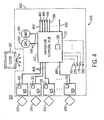
- the master navigation component 110 in one example comprises one or more reference coordinate components 305 and one or more rigid lever arm model components 310 and 340.
- the reference coordinate component 305 establishes a coordinate system for the vehicle 105.
- the rigid lever arm model component 310 comprises a base-line static position for the slave navigation component 115.
- the rigid lever arm model component 310 determines a base-line static lever arm for the slave navigation component 115 based on the base-line static position.
- the base-line static lever arm for the slave navigation component 115 comprises a three-dimensional position distance, or vector, between the master navigation component 110 and the slave navigation component 115.
- the rigid lever arm model component 310 cooperates with the reference coordinate component 305 to project the base-line static lever arm for the slave navigation component 115 in the coordinate system established by the reference coordinate component 305 to determine a translated static lever arm for the slave navigation component 115.
- the rigid lever arm model component 310 sends the translated static lever arm for the slave navigation component 115 as output 316 to a summing node 318.
- the slave navigation component 115 determines navigation measurement data for the slave navigation component 115 in reference to a coordinate system established by the slave navigation component 115.
- the slave navigation component 115 sends as output 320, the navigation measurement data for the slave navigation component 115 in reference to the coordinate system established by the slave navigation component 115 to the summing node 318.
- the summing node 318 combines the output 316 from the rigid lever arm model component 310 with the output 320 from the slave navigation component 115 to produce as output 322, navigation measurement data for the slave navigation component 115 in reference to the coordinate system established by the reference coordinate component 305.
- the output 322 comprising the navigation measurement data for the slave navigation component 115 in reference to the coordinate system established by the reference coordinate component 305 is enhanced through employment of an incremental dynamic lever arm correction component 324.
- the incremental dynamic lever arm correction component 324 comprises a model describing reactions of the vehicle 105 during motion.
- the incremental dynamic lever arm correction component 324 employs the model to provide positions for the slave navigation components 115 and 120 in relation to the reactions of the vehicle 105 during motion. For example, while in motion, the vehicle 105 reacts by bending. The bending of the vehicle 105 alters a lever arm (i.e., the three-dimensional distance vector) between the master navigation component 110 and the slave navigation component 115. As the vehicle 105 bends, the lever arm between the master navigation component 110 and the slave navigation component 115 changes.
- the incremental dynamic lever arm correction component 324 receives as input, an output 326 from the reference coordinate component 305, and an output 327 from the slave navigation component 115.
- the output 326 comprises the coordinate system established by the reference coordinate component 305.
- the output 327 comprises the navigation measurement data for the slave navigation component 115 in reference to the coordinate system established by the slave navigation component 115, similar to the output 320.
- the incremental dynamic lever arm correction component 324 employs the outputs 326 and 327 to determine a dynamic lever arm for the slave navigation component 115 in reference to the coordinate system established by the reference coordinate component 305.
- the incremental dynamic lever arm correction component 324 sends as output 328, the dynamic lever arm for the slave navigation component 115 to the summing node 318.
- the summing node 318 combines the outputs 316, 320, and 328 to produce the output 322.
- the summing node 318 generates the output 322 as comprising more accurate navigation measurement data for the slave navigation component 115 in reference to the coordinate system established by the reference coordinate component 305 for the vehicle 105 in motion.
- the output 328 of the incremental dynamic lever arm correction component 324 obtains more accuracy through employment of a filter 330, for example, a Kalman filter, as will be discussed herein.
- the filter 330 receives as input, the output 322 from the summing node 318.
- the filter 330 compares the output 322 for a given timestamp (i.e., the navigation measurement data for the slave navigation component 115 in reference to the coordinate system established by the reference coordinate component 305) with the navigation measurement data from the reference coordinate component 305 at the given timestamp.
- the filter 330 estimates errors in the output 322.
- the filter 330 provides as output 332, corrected navigation measurement data for the slave navigation component 115 in reference to the coordinate system established by the reference coordinate component 305.
- the slave navigation component 115 employs the output 332 to determine orientation, position, and velocity of the sensor 135 with respect to the coordinate system established by the reference coordinate component 305.
- the slave navigation component 115 employs the output 332 to adjust the coordinate system established by the slave navigation component 115.
- the filter 330 sends as output 334, the corrected navigation measurement data for the slave navigation component 115 in reference to the coordinate system established by the reference coordinate component 305 to the incremental dynamic lever arm correction component 324.
- the incremental dynamic lever arm correction component 324 employs the output 334 to correct the output 328, the dynamic lever arm for the slave navigation component 115.
- the incremental dynamic lever arm correction component 324, the slave navigation component 115 and the filter 330 cooperate to iteratively align a coordinate system of the slave navigation component 115 with the coordinate system established by the reference coordinate component 305.
- the slave navigation component 120, the sensor 140, the reference coordinate component 305, rigid lever arm model component 340, summing node 348, incremental dynamic lever arm correction component 354, and outputs 346, 350, 352, 358, 357, 362, and 364 interact in a similar fashion to the slave navigation component 115, the sensor 135, the reference coordinate component 305, the rigid lever arm model component 310, the summing node 318, the incremental dynamic lever arm correction component 324, outputs 316, 320, 322, 326, 327, 328, 332 and 334.
- the reference coordinate component 305, the rigid lever arm model components 310 and 315, incremental dynamic lever arm correction components 324 and 354, and the filter 330 comprise one or more instances of a recordable data storage medium 101, as described herein.
- the slave navigation component 115 sends as output 366, the navigation measurement data for the slave navigation component 115 to the incremental dynamic lever arm correction component 354.
- the incremental dynamic lever arm correction component 354 employs the output 366 to provide increased accuracy of the dynamic lever arm for the slave navigation component 120 in reference to the coordinate system established by the reference coordinate component 305.
- the slave navigation component 120 sends as output 368, the navigation measurement data for the slave navigation component 120 to the incremental dynamic lever arm correction component 324.
- the incremental dynamic lever arm correction component 324 employs the output 368 to provide increased accuracy of the dynamic lever arm for the slave navigation component 115 in reference to the coordinate system established by the reference coordinate component 305.
- the filter 330 receives as input, navigation measurement data from the master navigation component 110, and the slave navigation components 115 and 120.
- the filter 330 receives as input, output 370 from the reference coordinate component 305, the output 322 from the slave navigation component 115, and the output 352 from the slave navigation component 120.
- the filter 330 employs the outputs 322, 352, and 370 to establish a coordinate system.
- the filter 330 combines the outputs 322, 352, and 370 to establish the coordinate system, as will be appreciated by those skilled in the art.
- the filter 330 estimates errors in navigation measurement data received from the reference coordinate component 305, and the slave navigation components 115 and 120, and corrects the errors.
- the filter 330 sends as output 372, the corrected navigation measurement data with respect to the coordinate system established by the filter 330 to the reference coordinate component 305.
- the reference coordinate component 305 employs the output 372 to adjust a coordinate system established by the reference coordinate component 305.
- the reference coordinate component 305 employs the output 372 to adjust a base-line coordinate system established by the reference coordinate component 305.
- the filter 330 and the reference coordinate component 305 cooperate to align the coordinate system established by the reference coordinate component 305 and the coordinate system established by the filter 330.
- the filter 330 sends the outputs 332, 334, 362, and 364, the corrected navigation measurement data with respect to the coordinate system established by the filter 330 to the slave navigation components 115 and 120, and the incremental dynamic lever arm correction component 324 and 354.
- the vehicle 105 comprises a navigation network 402.
- the navigation network 402 comprises a navigation network hub 410, and one or more navigation components 415, 420, 425, and 430.
- the navigation components 415, 420, 425, and 430 in one example comprise navigation components of varying degrees of accuracy.
- the navigation components 415 and 420 comprise high performance navigation systems, similar to the master navigation component 110, and the navigation components 425 and 430 comprise lower performance navigation systems, similar to the slave navigation components 115, 120, 125, and/or 130.
- the navigation components 415, 420, 425, and 430 obtain navigation measurement data for the navigation components 415, 420, 425, and 430 and determine navigation parameters (i.e., orientations, positions, and velocities) for the sensors 135, 140, 145, and 150.
- navigation parameters i.e., orientations, positions, and velocities
- the navigation network hub 410 in one example receives the inertial measurement information from the navigation components 415, 420, 425, and 430.
- the navigation network hub 410 employs the navigation measurement data from the navigation components 415, 420, 425, and 430 to establish a coordinate system for the vehicle 105.
- the navigation network hub 410 determines one or more navigational parameters, for example, orientations, positions, and velocities, for the sensors 135, 140, 145, and 150 with respect to the coordinate system established by the navigation network hub 410.
- the navigation network hub 410 provides the navigation parameters (i.e.
- the navigation network hub 410 provides the orientation of the coordinate reference system established by the navigation network hub 410 as output 492.
- the navigation network hub 410, and the navigation components 415, 420, 425, and 430 in one example comprise one or more instances of a recordable data storage medium 101, as described herein.
- the network bus 495 comprises a high speed transmission bus.
- the network bus 495 comprises an Ethernet communication means.
- the navigation components 415, 420, 425, and 430 in one example employ the network bus 495 to transmit navigation measurement data to the navigation network hub 410.
- the navigation network hub 410 employs the network bus 495 to transmit corrected navigation measurement data 165, 170, 175, and 180 to the navigation components 415, 420, 425, and 430.
- the navigation network hub 410 employs the network bus 495 to provide outputs 482, 484, 486, 488, 490, and 492.
- the navigation network hub 410 employs the network bus 495 to communicate with the external positioning components 155 and 160.
- the navigation network hub 410 employs a standard protocol over the network bus 495 to provide a common interface to multiple external components, for example, the navigation components 415, 420, 425, and 430, the external positioning components 155 and 160, and one or more vehicle computers (not shown).
- the apparatus 100 in one example comprises a plurality of components such as one or more of electronic components, hardware components, and computer software components. A number of such components can be combined or divided in the apparatus 100.
- An exemplary component of the apparatus 100 employs and/or comprises a set and/or series of computer instructions written in or implemented with any of a number of programming languages, as will be appreciated by those skilled in the art.
- the apparatus 100 in one example employs one or more computer-readable signal-bearing media.
- the computer-readable signal-bearing media store software, firmware and/or assembly language for performing one or more portions of one or more embodiments of the invention.
- Examples of a computer-readable signal-bearing medium for the apparatus 100 comprise the recordable data storage medium 101 of the master navigation component 110, the slave navigation components 115, 120, 125, and 130, the reference coordinate component 305, the rigid lever arm model components 310 and 315, incremental dynamic lever arm correction components 324 and 354, the filter 330, the navigation network hub 410, and the navigation components 415, 420, 425, and 430.
- the computer-readable signal-bearing medium for the apparatus 100 in one example comprise one or more of a magnetic, electrical, optical, biological, and atomic data storage medium.
- the computer-readable signal-bearing medium comprises floppy disks, magnetic tapes, CD-ROMs, DVD-ROMs, hard disk drives, and electronic memory.
- the computer-readable signal-bearing medium comprises a modulated carrier signal transmitted over a network comprising or coupled with the apparatus 100, for instance, one or more of a telephone network, a local area network ("LAN”), a wide area network (“WAN”), the Internet, and a wireless network.
Landscapes
- Engineering & Computer Science (AREA)
- Radar, Positioning & Navigation (AREA)
- Remote Sensing (AREA)
- Physics & Mathematics (AREA)
- General Physics & Mathematics (AREA)
- Automation & Control Theory (AREA)
- Manufacturing & Machinery (AREA)
- Navigation (AREA)
Claims (10)
- Gerät (100), umfassend:Eine Master-Navigationskomponente (110), die ein erstes Koordinatensystem herstellt; undein oder mehr Slave-Navigationskomponenten (115, 120, 125, 130), die Navigationsmessdaten der einen oder mehr Slave-Navigationskomponenten jeweils in ihrem eigenen sekundären Koordinatensystem bestimmen;wobei die eine oder mehr Slave-Navigationskomponenten die Navigationsmessdaten der einen oder mehr Slave-Komponenten jeweils in ihrem eigenen sekundären Koordinatensystem der Master-Navigationskomponente zur Verfügung stellen;wobei die Master-Navigationskomponente die Navigationsmessdaten der einen oder mehr Slave-Komponenten jeweils in ihrem eigenen sekundären Koordinatensystem mit Navigationsmessdaten für die Master-Navigationskomponente in dem ersten Koordinatensystem vergleicht;wobei die Master-Navigationskomponente die Navigationsmessdaten der einen oder mehr Slave-Navigationskomponenten in dem zweiten Koordinatensystem in Navigationsmessdaten der einen oder mehr Slave-Navigationskomponenten in dem ersten Koordinatensystem übersetzt;wobei die Master-Navigationskomponente an einer ersten Stelle in einem Fahrzeug angeordnet ist, und eine erste der Slave-Navigationskomponenten an einer zweiten Stelle in dem Fahrzeug angeordnet ist, wobei das erste und das zweite Koordinatensystem der ersten beziehungsweise der zweiten Stelle zugeordnet sind;eine Statikstelle-Komponente, die mit der Master-Navigationskomponente gekoppelt ist, wobei die Statikstelle-Komponente Statikinformationen über den Abstand zwischen der ersten und der zweiten Stelle zur Verfügung stellt;eine Dynamikstelle-Komponente, die mit der Master-Navigationskomponente gekoppelt ist, wobei die Dynamikstelle-Komponente Dynamikinformationen über die Verlagerung zwischen der ersten und der zweiten Stelle zur Verfügung stellt, wobei die Verlagerung zwischen der ersten Slave-Navigationskomponente und der Master-Navigationskomponente aufgrund einer physikalischen Auslenkung der zweiten Stelle relativ zur ersten Stelle variabel ist, wobei die Master-Navigationskomponente den Fehler in den Navigationsmessdaten der ersten Slave-Navigationskomponente an der zweiten Stelle basierend auf den statischen und den dynamischen Verlagerungsinformationen abschätzt;wobei die Master- und die Slave-Navigationskomponente jeweils eine Zeitsynchronisationskomponente enthalten, die Master- und Slave-Navigationsmessdaten mit Zeitinformationen derart codiert, dass Master- und Slave-Messdaten im Wesentlichen ab der gleichen Zeit verwendet werden können bei der Abschätzung des Fehlers in den Navigationsmessdaten der ersten Slave-Navigationskomponente an der zweiten Stelle basierend auf den dynamischen Verlagerungsinformationen.
- Gerät nach Anspruch 1, wobei die Master-Navigationskomponente Fehler in den Navigationsmessdaten der einen oder mehr Slave-Navigationskomponenten abschätzt.
- Gerät nach Anspruch 2, wobei die Master-Navigationskomponente Fehler in den Navigationsmessdaten der einen oder mehr Slave-Navigationskomponenten durch Verwendung eines Kalman-Filters (330) abschätzt.
- Gerät nach Anspruch 2, wobei die Master-Navigationskomponente die Navigationsmessdaten der einen oder mehr Slave-Navigationskomponenten jeweils in ihrem eigenen sekundären Koordinatensystem basierend auf den abgeschätzten Fehlern korrigiert.
- Gerät nach Anspruch 1, wobei die Master-Navigationskomponente die Navigationsmessdaten der ersten Slave-Navigationskomponente basierend auf dem statischen Abstand und dynamischen Verlagerungsinformationen korrigiert.
- Gerät nach Anspruch 5, wobei die Master-Navigationskomponente die Navigationsmessdaten der ersten Slave-Navigationskomponente in dem zweiten Koordinatensystem in Navigationsmessdaten in dem ersten Koordinatensystem basierend auf den Navigationsmessdaten übersetzt, die um statische und dynamische Verlagerungsinformationen korrigiert sind.
- Gerät nach Anspruch 1, ferner umfassend ein Summierelement, das Eingaben von der Statikstelle-Komponente und der Dynamikstelle-Komponente empfängt, wobei das Summierelement eine Ausgabe an das Filter liefert, das Abschätzungen eines Fehlers in den Navigationsmessdaten des zweiten Koordinatensystems relativ zum ersten Koordinatensystem zur Verfügung stellt.
- Verfahren zum Bestimmen von Navigationsinformationen, umfassend die Schritte:Erzeugen von Master-Navigationsmessdaten (210) mit einem ersten Koordinatensystem an einer ersten Stelle in einem Fahrzeug;Erzeugen einer oder mehrerer Sätze von Slave-Navigationsmessdaten mit einem oder mehr zusätzlichen Koordinatensystemen an einer oder mehr zusätzlichen Stellen in dem Fahrzeug;Bestimmen dynamischer Informationen der Verlagerung zwischen der ersten und den zusätzlichen Stellen;Erzeugen statischer Informationen des Abstands zwischen der ersten und der zweiten Stelle;dadurch gekennzeichnet, dass das Verfahren ferner umfasst:Abschätzen von Fehlern (225) in den Slave-Navigationsmessdaten basierend auf den Master-Navigationsmessdaten und den statischen und den dynamischen Verlagerungsinformationen, wobei die dynamischen Verlagerungsinformationen aufgrund von physikalischen Auslenkungen der zweiten Stelle relativ zu der ersten Stelle variabel sind;Korrigieren (230) der Slave-Navigationsmessdaten basierend auf dem abgeschätzten Fehler;Übersetzen (235) der korrigierten Slave-Navigationsmessdaten in Navigationsmessdaten in dem ersten Koordinatensystem;Codieren der Master- und der Slave-Messdaten mit Zeitinformationen derart, dass die Master- und die Slave-Messdaten im Wesentlichen ab der gleichen Zeit verwendet werden bei der Abschätzung des Fehlers in den Navigationsmessdaten der ersten Slave-Navigationskomponente an der zweiten Stelle.
- Verfahren nach Anspruch 8, ferner umfassend den Schritt des Summierens der Master- und der Slave-Messdaten und der Statik- und der Dynamikstelleinformationen, und Erzeugen einer Ausgabe basierend auf der Summierung, wobei die Fehlerabschätzung auf der Ausgabe basiert.
- Verfahren nach Anspruch 9, ferner umfassend ein Rückkopplungsregelsystem basierend auf den Master- und den Slave-Navigationsdaten, den statischen und den dynamischen Informationen, der Summierungsausgabe sowie der geschätzten Fehlerinformationen, um die Position der zweiten Stelle relativ zu der ersten Stelle zu aktualisieren.
Applications Claiming Priority (2)
| Application Number | Priority Date | Filing Date | Title |
|---|---|---|---|
| US57021704P | 2004-05-12 | 2004-05-12 | |
| PCT/US2005/016207 WO2005114106A1 (en) | 2004-05-12 | 2005-05-09 | System and method for aligning multiple navignation components |
Publications (2)
| Publication Number | Publication Date |
|---|---|
| EP1745261A1 EP1745261A1 (de) | 2007-01-24 |
| EP1745261B1 true EP1745261B1 (de) | 2012-11-14 |
Family
ID=34972582
Family Applications (1)
| Application Number | Title | Priority Date | Filing Date |
|---|---|---|---|
| EP05760654A Expired - Lifetime EP1745261B1 (de) | 2004-05-12 | 2005-05-09 | System und verfahren zur ausrichtung mehrerer navigationskomponenten |
Country Status (5)
| Country | Link |
|---|---|
| US (1) | US8224574B2 (de) |
| EP (1) | EP1745261B1 (de) |
| JP (1) | JP4819802B2 (de) |
| CA (1) | CA2565143C (de) |
| WO (1) | WO2005114106A1 (de) |
Families Citing this family (18)
| Publication number | Priority date | Publication date | Assignee | Title |
|---|---|---|---|---|
| MX2007001292A (es) | 2004-08-03 | 2007-07-04 | Geneart Ag | Metodo para modular la expresion genica al alterar el contendido de cpg. |
| US8874477B2 (en) | 2005-10-04 | 2014-10-28 | Steven Mark Hoffberg | Multifactorial optimization system and method |
| US8024119B2 (en) * | 2007-08-14 | 2011-09-20 | Honeywell International Inc. | Systems and methods for gyrocompass alignment using dynamically calibrated sensor data and an iterated extended kalman filter within a navigation system |
| FR2924215B1 (fr) * | 2007-11-23 | 2010-01-01 | Thales Sa | Systeme comprenant deux instruments combines et procede d'alignement du systeme |
| DE102010034792A1 (de) * | 2010-08-18 | 2012-02-23 | Astrium Gmbh | Vorrichtung und Verfahren zur dreidimensionalen Positionierung |
| CN103292827B (zh) * | 2012-03-05 | 2016-10-05 | 联想(北京)有限公司 | 数据校正方法和电子设备 |
| US9423426B1 (en) | 2012-08-03 | 2016-08-23 | The United States Of America As Represented By The Administrator Of National Aeronautics And Space Administration | Sampling and control circuit board for an inertial measurement unit |
| FR3000219B1 (fr) * | 2012-12-26 | 2015-01-09 | Sagem Defense Securite | Procede de comparaison de deux centrales inertielles solidaires d'un meme porteur |
| JP2015055534A (ja) * | 2013-09-11 | 2015-03-23 | 株式会社リコー | 情報処理装置、情報処理装置の制御プログラム及び情報処理装置の制御方法 |
| US9134124B2 (en) * | 2014-02-11 | 2015-09-15 | Caterpillar Inc. | System and method for estimation of machine position |
| US9377309B2 (en) * | 2014-03-31 | 2016-06-28 | Honeywell International Inc. | Global positioning system (GPS) self-calibrating lever arm function |
| JP6471749B2 (ja) * | 2014-04-25 | 2019-02-20 | 日本電気株式会社 | 位置姿勢推定装置、画像処理装置及び位置姿勢推定方法 |
| CN105203129B (zh) * | 2015-10-13 | 2019-05-07 | 上海华测导航技术股份有限公司 | 一种惯导装置初始对准方法 |
| KR101671671B1 (ko) | 2016-05-25 | 2016-11-01 | 주식회사 티씨케이 | 반도체 제조용 부품의 재생방법과 그 재생장치 및 재생부품 |
| US10473793B2 (en) * | 2017-01-19 | 2019-11-12 | Ford Global Technologies, Llc | V2V collaborative relative positioning system |
| GB201714979D0 (en) * | 2017-09-18 | 2017-11-01 | Trw Ltd | Dectecting misalignment |
| US10838070B1 (en) * | 2018-03-28 | 2020-11-17 | Rockwell Collins, Inc. | Systems and methods for managing global navigation satellite system (GNSS) receivers |
| CN112683261B (zh) * | 2020-11-19 | 2022-10-14 | 电子科技大学 | 一种基于速度预测的无人机鲁棒性导航方法 |
Family Cites Families (61)
| Publication number | Priority date | Publication date | Assignee | Title |
|---|---|---|---|---|
| DE3438719A1 (de) | 1984-10-23 | 1986-04-24 | Bodenseewerk Gerätetechnik GmbH, 7770 Überlingen | Anordnung zur gegenseitigen lagebestimmung von mutter- und tochter-traegheitsnavigationssystemen |
| US5640325A (en) * | 1988-09-13 | 1997-06-17 | Litton Systems, Inc. | Sensor array dynamic position and orientation determination system |
| US4918609A (en) * | 1988-10-11 | 1990-04-17 | Koji Yamawaki | Satellite-based position-determining system |
| FR2668447B1 (fr) * | 1990-10-29 | 1993-01-22 | Aerospatiale | Systeme pour l'alignement de la centrale inertielle d'un vehicule porte sur celle d'un vehicule porteur. |
| DE4225413C1 (de) * | 1992-07-31 | 1994-03-17 | Deutsche Forsch Luft Raumfahrt | Verfahren zur Bewegungskompensation von SAR-Bildern mittels eines Kurs/Lage-Referenzsystems und Einrichtung zur Durchführung des Verfahrens |
| DE4403190C1 (de) * | 1994-02-02 | 1995-07-27 | Deutsche Forsch Luft Raumfahrt | Verfahren zum Bestimmen der Position eines Flugzeugs aus Beschleunigungsdaten eines Inertialsystems sowie aus Ausgabedaten eines Navigationssystems und Einrichtung zur Durchführung des Verfahrens |
| US5708436A (en) * | 1996-06-24 | 1998-01-13 | Northrop Grumman Corporation | Multi-mode radar system having real-time ultra high resolution synthetic aperture radar (SAR) capability |
| US6011505A (en) * | 1996-07-11 | 2000-01-04 | Science Applications International Corporation | Terrain elevation measurement by interferometric synthetic aperture radar (IFSAR) |
| US5923278A (en) * | 1996-07-11 | 1999-07-13 | Science Applications International Corporation | Global phase unwrapping of interferograms |
| US6046695A (en) * | 1996-07-11 | 2000-04-04 | Science Application International Corporation | Phase gradient auto-focus for SAR images |
| US5936571A (en) * | 1997-01-31 | 1999-08-10 | Lockheed Martin Corporation | Integrated GPS/interference location system |
| US5929805A (en) * | 1997-04-10 | 1999-07-27 | Tadros; Alfred | Differential phase measurement scheme for a multiplexing GPS attitude receiver |
| JP3833786B2 (ja) * | 1997-08-04 | 2006-10-18 | 富士重工業株式会社 | 移動体の3次元自己位置認識装置 |
| US6094163A (en) * | 1998-01-21 | 2000-07-25 | Min-I James Chang | Ins alignment method using a doppler sensor and a GPS/HVINS |
| JP2000022698A (ja) * | 1998-06-30 | 2000-01-21 | Yazaki Corp | 車両ネットワークシステム及び車両機器状態制御方法 |
| US6282496B1 (en) * | 1999-10-29 | 2001-08-28 | Visteon Technologies, Llc | Method and apparatus for inertial guidance for an automobile navigation system |
| US6456906B1 (en) * | 1999-11-18 | 2002-09-24 | Trimble Navigation, Ltd | Satellite positioning-based guidance system that utilizes simulated inertial navigation system |
| US7707612B2 (en) * | 2000-04-07 | 2010-04-27 | Live Tv, Inc. | Aircraft in-flight entertainment system with soft fail and flight information features and associated methods |
| US20030200547A1 (en) * | 2000-04-07 | 2003-10-23 | Live Tv, Inc. | Aircraft in-flight entertainment system receiving terrestrial television broadcast signals and associated methods |
| US20030229897A1 (en) * | 2000-04-07 | 2003-12-11 | Live Tv, Inc. | Aircraft in-flight entertainment system providing passenger specific advertisements, and associated methods |
| US8803971B2 (en) * | 2000-04-07 | 2014-08-12 | Livetv, Llc | Aircraft system providing passenger entertainment and surveillance features, and associated methods |
| US6208307B1 (en) * | 2000-04-07 | 2001-03-27 | Live Tv, Inc. | Aircraft in-flight entertainment system having wideband antenna steering and associated methods |
| US6751801B1 (en) * | 2000-04-07 | 2004-06-15 | Live Tv, Inc. | Aircraft in-flight entertainment system having enhanced antenna steering and associated methods |
| US6748597B1 (en) * | 2000-04-07 | 2004-06-08 | Live Tv, Inc. | Upgradable aircraft in-flight entertainment system and associated upgrading methods |
| US7587733B2 (en) * | 2000-04-07 | 2009-09-08 | Livetv, Llc | Aircraft in-flight entertainment system providing weather information and associated methods |
| US20030192052A1 (en) * | 2000-04-07 | 2003-10-09 | Live Tv, Inc. | Aircraft in-flight entertainment system generating a pricing structure for available features, and associated methods |
| EP1328775A1 (de) * | 2000-07-28 | 2003-07-23 | Litton Systems, Inc. | Lageausrichtung eines slave-trägheitsmesssystems |
| US6799116B2 (en) * | 2000-12-15 | 2004-09-28 | Trimble Navigation Limited | GPS correction methods, apparatus and signals |
| US6424914B1 (en) * | 2000-12-26 | 2002-07-23 | American Gnc Corporation | Fully-coupled vehicle positioning method and system thereof |
| US6529820B2 (en) * | 2001-04-10 | 2003-03-04 | Ion Tomescu | System and method for determining the 3D position of aircraft, independently onboard and on the ground, for any operation within a “gate-to-gate” concept |
| US6732024B2 (en) * | 2001-05-07 | 2004-05-04 | The Board Of Trustees Of The Leland Stanford Junior University | Method and apparatus for vehicle control, navigation and positioning |
| US6816117B2 (en) * | 2001-05-24 | 2004-11-09 | The United States Of America As Represented By The United States National Aeronautics And Space Administration | Distributed antenna system and method |
| US6965816B2 (en) * | 2001-10-01 | 2005-11-15 | Kline & Walker, Llc | PFN/TRAC system FAA upgrades for accountable remote and robotics control to stop the unauthorized use of aircraft and to improve equipment management and public safety in transportation |
| US6687185B1 (en) * | 2002-08-29 | 2004-02-03 | Micron Technology, Inc. | Method and apparatus for setting and compensating read latency in a high speed DRAM |
| US6944542B1 (en) * | 2003-03-12 | 2005-09-13 | Trimble Navigation, Ltd. | Position determination system for movable objects or personnel |
| US6762974B1 (en) * | 2003-03-18 | 2004-07-13 | Micron Technology, Inc. | Method and apparatus for establishing and maintaining desired read latency in high-speed DRAM |
| US6813561B2 (en) * | 2003-03-25 | 2004-11-02 | Ford Global Technologies, Llc | Relative positioning for vehicles using GPS enhanced with bluetooth range finding |
| US7626541B2 (en) * | 2003-05-23 | 2009-12-01 | Honeywell International Inc. | Orientation transfer device and method |
| US7561493B2 (en) * | 2003-05-30 | 2009-07-14 | Fairfield Industries, Inc. | Method and apparatus for land based seismic data acquisition |
| US7310287B2 (en) * | 2003-05-30 | 2007-12-18 | Fairfield Industries Incorporated | Method and apparatus for seismic data acquisition |
| CA2556009A1 (en) * | 2003-08-08 | 2005-02-17 | Atair Aerospace, Inc. | High altitude parachute navigation flight computer |
| US7032857B2 (en) * | 2003-08-19 | 2006-04-25 | Cuong Tu Hua | Multi-sensor guidance system for extreme force launch shock applications |
| JP4073022B2 (ja) * | 2003-09-05 | 2008-04-09 | アルパイン株式会社 | 車載装置及び他車位置算出方法 |
| US20050132112A1 (en) * | 2003-12-10 | 2005-06-16 | Pawlowski J. T. | I/O energy reduction using previous bus state and I/O inversion bit for bus inversion |
| US7406608B2 (en) * | 2004-02-05 | 2008-07-29 | Micron Technology, Inc. | Fast and compact circuit for bus inversion |
| DE602005016843D1 (de) * | 2004-05-13 | 2009-11-05 | Northrop Grumman Corp | Interferometrisches messsystem |
| US7065001B2 (en) * | 2004-08-04 | 2006-06-20 | Micron Technology, Inc. | Method and apparatus for initialization of read latency tracking circuit in high-speed DRAM |
| DE102004039460B3 (de) * | 2004-08-14 | 2006-04-20 | Deere & Company, Moline | System zur Bestimmung der relativen Position eines zweiten landwirtschaftlichen Fahrzeugs in Bezug auf ein erstes landwirtschaftliches Fahrzeug |
| US7590589B2 (en) * | 2004-09-10 | 2009-09-15 | Hoffberg Steven M | Game theoretic prioritization scheme for mobile ad hoc networks permitting hierarchal deference |
| US7177638B2 (en) * | 2004-12-28 | 2007-02-13 | Live Tv, Llc | Aircraft in-flight entertainment system including digital radio service and associated methods |
| US8776146B2 (en) * | 2004-12-28 | 2014-07-08 | Livetv, Llc | Aircraft in-flight entertainment system including a distributed digital radio service and associated methods |
| US7280825B2 (en) * | 2004-12-28 | 2007-10-09 | Live Tv, Llc | Aircraft in-flight entertainment system including low power transceivers and associated methods |
| US7587734B2 (en) * | 2004-12-28 | 2009-09-08 | Livetv, Llc | Aircraft in-flight entertainment system including a registration feature and associated methods |
| US9509937B2 (en) * | 2004-12-28 | 2016-11-29 | Livetv, Llc | Aircraft in-flight entertainment system with a distributed memory and associated methods |
| US7676225B2 (en) * | 2004-12-28 | 2010-03-09 | Livetv, Llc | Area entertainment system including digital radio service and associated methods |
| US7681357B2 (en) * | 2005-01-25 | 2010-03-23 | Dyas Drew C | Apparatuses and systems for growing nursery stock |
| US7844397B2 (en) * | 2005-03-29 | 2010-11-30 | Honeywell International Inc. | Method and apparatus for high accuracy relative motion determination using inertial sensors |
| US8874477B2 (en) * | 2005-10-04 | 2014-10-28 | Steven Mark Hoffberg | Multifactorial optimization system and method |
| US7579984B2 (en) * | 2005-11-23 | 2009-08-25 | The Boeing Company | Ultra-tightly coupled GPS and inertial navigation system for agile platforms |
| US7620404B2 (en) * | 2005-12-22 | 2009-11-17 | Pascal Chesnais | Methods and apparatus for organizing and presenting contact information in a mobile communication system |
| EP2005405A4 (de) * | 2006-03-21 | 2010-12-29 | Skymeter Corp | Privates auditierbares fahrzeugpositionsbestimmungssystem und onboard-einheit dafür |
-
2005
- 2005-05-09 US US11/124,724 patent/US8224574B2/en active Active
- 2005-05-09 WO PCT/US2005/016207 patent/WO2005114106A1/en not_active Ceased
- 2005-05-09 CA CA2565143A patent/CA2565143C/en not_active Expired - Fee Related
- 2005-05-09 EP EP05760654A patent/EP1745261B1/de not_active Expired - Lifetime
- 2005-05-09 JP JP2007513257A patent/JP4819802B2/ja not_active Expired - Fee Related
Also Published As
| Publication number | Publication date |
|---|---|
| EP1745261A1 (de) | 2007-01-24 |
| JP4819802B2 (ja) | 2011-11-24 |
| US20050256637A1 (en) | 2005-11-17 |
| WO2005114106A1 (en) | 2005-12-01 |
| US8224574B2 (en) | 2012-07-17 |
| JP2007537447A (ja) | 2007-12-20 |
| CA2565143C (en) | 2014-07-08 |
| CA2565143A1 (en) | 2005-12-01 |
Similar Documents
| Publication | Publication Date | Title |
|---|---|---|
| EP1745261B1 (de) | System und verfahren zur ausrichtung mehrerer navigationskomponenten | |
| CN112097763B (zh) | 一种基于mems imu/磁力计/dvl组合的水下运载体组合导航方法 | |
| EP2187170B1 (de) | Verfahren und System zur Einschätzung von Trägheitssensorfehlern in einer ferngesteuerten Trägheitsmesseinheit | |
| US11867803B2 (en) | Global positioning system for compensating for error of relative position between vehicles | |
| CN111189441A (zh) | 一种多源自适应容错联邦滤波组合导航系统及导航方法 | |
| US8082099B2 (en) | Aircraft navigation using the global positioning system and an attitude and heading reference system | |
| CN107643534A (zh) | 一种基于gnss/ins深组合导航的双速率卡尔曼滤波方法 | |
| CA3003298A1 (en) | Gnss and inertial navigation system utilizing relative yaw as an observable for an ins filter | |
| US7058505B1 (en) | System for navigation redundancy | |
| CN118426017B (zh) | 一种基于农业场景自定义坐标的电台rtk组合导航定位方法 | |
| CN112083425B (zh) | 一种引入径向速度的sins/lbl紧组合导航方法 | |
| CN114136323B (zh) | 基于运动补偿下tdoa量测的auv协同导航方法 | |
| US7406379B2 (en) | System for interferometric sensing | |
| CN113155134B (zh) | 一种基于惯性信息辅助的水声信道跟踪与预测方法 | |
| CN118243142A (zh) | 基于天导信息的惯导误差重调方法、电子设备及存储介质 | |
| CN114624754B (zh) | 一种时空定位与近场补偿的自动驾驶定位装置与方法 | |
| CN115616634A (zh) | 一种基于gnss信息的绕飞卫星相对导航方法 | |
| CN119915279B (zh) | 一种声学多普勒延迟信息辅助组合导航方法 | |
| CN119334341A (zh) | 导航系统的误差补偿方法、装置和可读存储介质 | |
| CN120871145A (zh) | 一种自主水下机器人集群协同定位方法及系统 | |
| CN120084320A (zh) | 基于周期声源场的sins/rdosb联合定位方法与系统 | |
| Kaniewski et al. | Positioning with AHRS/odometer/GPS system |
Legal Events
| Date | Code | Title | Description |
|---|---|---|---|
| PUAI | Public reference made under article 153(3) epc to a published international application that has entered the european phase |
Free format text: ORIGINAL CODE: 0009012 |
|
| 17P | Request for examination filed |
Effective date: 20061108 |
|
| AK | Designated contracting states |
Kind code of ref document: A1 Designated state(s): DE FR GB IT |
|
| DAX | Request for extension of the european patent (deleted) | ||
| RBV | Designated contracting states (corrected) |
Designated state(s): DE FR GB IT |
|
| 17Q | First examination report despatched |
Effective date: 20090325 |
|
| RAP1 | Party data changed (applicant data changed or rights of an application transferred) |
Owner name: NORTHROP GRUMMAN SYSTEMS CORPORATION |
|
| GRAP | Despatch of communication of intention to grant a patent |
Free format text: ORIGINAL CODE: EPIDOSNIGR1 |
|
| GRAS | Grant fee paid |
Free format text: ORIGINAL CODE: EPIDOSNIGR3 |
|
| GRAA | (expected) grant |
Free format text: ORIGINAL CODE: 0009210 |
|
| AK | Designated contracting states |
Kind code of ref document: B1 Designated state(s): DE FR GB IT |
|
| REG | Reference to a national code |
Ref country code: GB Ref legal event code: FG4D |
|
| REG | Reference to a national code |
Ref country code: DE Ref legal event code: R096 Ref document number: 602005036986 Country of ref document: DE Effective date: 20130110 |
|
| RAP2 | Party data changed (patent owner data changed or rights of a patent transferred) |
Owner name: NORTHROP GRUMMAN SYSTEMS CORPORATION |
|
| REG | Reference to a national code |
Ref country code: DE Ref legal event code: R082 Ref document number: 602005036986 Country of ref document: DE Representative=s name: PATENTANWAELTE BETTEN & RESCH, DE |
|
| REG | Reference to a national code |
Ref country code: DE Ref legal event code: R082 Ref document number: 602005036986 Country of ref document: DE Representative=s name: BETTEN & RESCH PATENT- UND RECHTSANWAELTE PART, DE Effective date: 20130527 Ref country code: DE Ref legal event code: R081 Ref document number: 602005036986 Country of ref document: DE Owner name: NORTHROP GRUMMAN GUIDANCE AND ELECTRONICS COMP, US Free format text: FORMER OWNER: NORTHROP GRUMMAN CORP., LOS ANGELES, CALIF., US Effective date: 20121031 Ref country code: DE Ref legal event code: R081 Ref document number: 602005036986 Country of ref document: DE Owner name: NORTHROP GRUMMAN GUIDANCE AND ELECTRONICS COMP, US Free format text: FORMER OWNER: NORTHROP GRUMMAN SYSTEMS CORPORATION, LOS ANGELES, CALIF., US Effective date: 20130527 Ref country code: DE Ref legal event code: R082 Ref document number: 602005036986 Country of ref document: DE Representative=s name: PATENTANWAELTE BETTEN & RESCH, DE Effective date: 20130527 Ref country code: DE Ref legal event code: R081 Ref document number: 602005036986 Country of ref document: DE Owner name: NORTHROP GRUMMAN GUIDANCE AND ELECTRONICS COMP, US Free format text: FORMER OWNER: NORTHROP GRUMMAN CORP., LOS ANGELES, US Effective date: 20121031 Ref country code: DE Ref legal event code: R081 Ref document number: 602005036986 Country of ref document: DE Owner name: NORTHROP GRUMMAN GUIDANCE AND ELECTRONICS COMP, US Free format text: FORMER OWNER: NORTHROP GRUMMAN SYSTEMS CORPORATION, LOS ANGELES, US Effective date: 20130527 |
|
| RAP2 | Party data changed (patent owner data changed or rights of a patent transferred) |
Owner name: NORTHROP GRUMMAN GUIDANCE AND ELECTRONICS COMPANY, |
|
| REG | Reference to a national code |
Ref country code: GB Ref legal event code: 732E Free format text: REGISTERED BETWEEN 20130808 AND 20130814 |
|
| PLBE | No opposition filed within time limit |
Free format text: ORIGINAL CODE: 0009261 |
|
| STAA | Information on the status of an ep patent application or granted ep patent |
Free format text: STATUS: NO OPPOSITION FILED WITHIN TIME LIMIT |
|
| REG | Reference to a national code |
Ref country code: FR Ref legal event code: TP Owner name: NORTHROP GRUMMAN GUIDANCE AND ELECTRONICS COMPANY, Effective date: 20130830 |
|
| 26N | No opposition filed |
Effective date: 20130815 |
|
| REG | Reference to a national code |
Ref country code: DE Ref legal event code: R097 Ref document number: 602005036986 Country of ref document: DE Effective date: 20130815 |
|
| REG | Reference to a national code |
Ref country code: FR Ref legal event code: PLFP Year of fee payment: 12 |
|
| REG | Reference to a national code |
Ref country code: FR Ref legal event code: PLFP Year of fee payment: 13 |
|
| PGFP | Annual fee paid to national office [announced via postgrant information from national office to epo] |
Ref country code: FR Payment date: 20170523 Year of fee payment: 13 Ref country code: GB Payment date: 20170519 Year of fee payment: 13 |
|
| GBPC | Gb: european patent ceased through non-payment of renewal fee |
Effective date: 20180509 |
|
| PG25 | Lapsed in a contracting state [announced via postgrant information from national office to epo] |
Ref country code: FR Free format text: LAPSE BECAUSE OF NON-PAYMENT OF DUE FEES Effective date: 20180531 Ref country code: GB Free format text: LAPSE BECAUSE OF NON-PAYMENT OF DUE FEES Effective date: 20180509 |
|
| P01 | Opt-out of the competence of the unified patent court (upc) registered |
Effective date: 20230607 |
|
| PGFP | Annual fee paid to national office [announced via postgrant information from national office to epo] |
Ref country code: DE Payment date: 20240521 Year of fee payment: 20 |
|
| PGFP | Annual fee paid to national office [announced via postgrant information from national office to epo] |
Ref country code: IT Payment date: 20240524 Year of fee payment: 20 |
|
| REG | Reference to a national code |
Ref country code: DE Ref legal event code: R071 Ref document number: 602005036986 Country of ref document: DE |