EP1503178A2 - Verfahren zur Klassifikation von Routensegmenten eines Navigationssystems und ein entsprechendes Navigationssystem - Google Patents
Verfahren zur Klassifikation von Routensegmenten eines Navigationssystems und ein entsprechendes Navigationssystem Download PDFInfo
- Publication number
- EP1503178A2 EP1503178A2 EP04103273A EP04103273A EP1503178A2 EP 1503178 A2 EP1503178 A2 EP 1503178A2 EP 04103273 A EP04103273 A EP 04103273A EP 04103273 A EP04103273 A EP 04103273A EP 1503178 A2 EP1503178 A2 EP 1503178A2
- Authority
- EP
- European Patent Office
- Prior art keywords
- route
- segments
- navigation system
- segment
- shortest
- Prior art date
- Legal status (The legal status is an assumption and is not a legal conclusion. Google has not performed a legal analysis and makes no representation as to the accuracy of the status listed.)
- Granted
Links
Images
Classifications
-
- G—PHYSICS
- G01—MEASURING; TESTING
- G01C—MEASURING DISTANCES, LEVELS OR BEARINGS; SURVEYING; NAVIGATION; GYROSCOPIC INSTRUMENTS; PHOTOGRAMMETRY OR VIDEOGRAMMETRY
- G01C21/00—Navigation; Navigational instruments not provided for in groups G01C1/00 - G01C19/00
- G01C21/26—Navigation; Navigational instruments not provided for in groups G01C1/00 - G01C19/00 specially adapted for navigation in a road network
- G01C21/34—Route searching; Route guidance
- G01C21/3446—Details of route searching algorithms, e.g. Dijkstra, A*, arc-flags or using precalculated routes
-
- G—PHYSICS
- G09—EDUCATION; CRYPTOGRAPHY; DISPLAY; ADVERTISING; SEALS
- G09B—EDUCATIONAL OR DEMONSTRATION APPLIANCES; APPLIANCES FOR TEACHING, OR COMMUNICATING WITH, THE BLIND, DEAF OR MUTE; MODELS; PLANETARIA; GLOBES; MAPS; DIAGRAMS
- G09B29/00—Maps; Plans; Charts; Diagrams, e.g. route diagram
- G09B29/10—Map spot or coordinate position indicators; Map reading aids
Definitions
- the invention relates to a method for a Navigation system and a corresponding navigation system, with the involvement of different Route section classes as short as possible overall route between a start and destination node is determined.
- Road classes or layers used to Increase processing speed and fast restricting accessible data sets, this being For example, this happens because near Start and aim all roads and at some distance from start and Target only "important" roads, for example highways, be taken into account.
- the necessary classification The roads are usually used by the card manufacturer delivered and oriented to given Road attributes, such as highway, federal highway etc. Such a classification does not press necessarily a significance for a shortest route and This often leads to unnecessarily long journeys. exaggerated Expressed in France, this process leads each one Route from A to B via Paris.
- the object underlying the invention is now to a method for classifying route segments in one Navigation system and a corresponding navigation system specify where the selection of route segments improves or a manual correction is largely avoided.
- the invention consists essentially in that starting from conventional road classes, so from the to expected speed of a respective Road segments, automatically for all road segments one Significance is determined, with the basic idea therein is that a road segment is significant if it is "in the middle of a "long" shortest path.
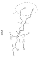
- the two start nodes S1 and S2 here belong, by way of example, to a common cluster C, which can be used to simplify the calculation as a common start region in the search for the shortest paths.
- the shortest connection routes 1 to 3 all have a respective common route segment e, the end points of the route segment being denoted by v and w.
- the maximum distance max to a start or Destination node in any of these shortest paths certainly. So it is at the path 1, the distance between the start node S1 and the point v of the route segment e as well the distance between the point w of the route segment e and the destination node Z1 determined and from both distances the respective minimum min1 formed. In a similar way this is also done for all other shortest paths, For example, the paths 2 and 3, where the minimum Distances min2 and min3 are determined.
- the route segments can thus, due to their significance certain classes or layers are assigned, this being For example, this happens because the first x percent the sorted segments the first layer, the next y Percent to the second layer, and so on.
- the routes or route segments are typically Roads or road segments in navigation systems for cars or trucks.
- the invention is, however, in principle in all Navigation systems, e.g. also in ships or planes, apply, whose route segments, for example, different allow maximum travel speeds.
Landscapes
- Engineering & Computer Science (AREA)
- Physics & Mathematics (AREA)
- Radar, Positioning & Navigation (AREA)
- Remote Sensing (AREA)
- Theoretical Computer Science (AREA)
- General Physics & Mathematics (AREA)
- Mathematical Physics (AREA)
- Business, Economics & Management (AREA)
- Educational Administration (AREA)
- Educational Technology (AREA)
- Automation & Control Theory (AREA)
- Navigation (AREA)
Abstract
Description
Die kürzesten Verbindungsrouten 1 bis 3 weisen alle ein jeweiliges gemeinsames Routensegment e auf, wobei die Endpunkte des Routensegments mit v und w bezeichnet sind.
Claims (6)
- Verfahren zur Klassifikation von Routensegmenten eines Navigationssystems,bei dem zunächst alle kürzesten Pfade (1, 2, 3,..) in einem Routennetz berechnet werden, wobei jeder dieser Pfade einen Startknoten (S1,S2,S3,..) und einen Zielknoten (Z1,Z2,Z3,...) oder ein Startgebiet (C) aufweist,bei dema) für ein jeweiliges Routensegment (e) innerhalb aller kürzesten Pfade (1,2,3), die dieses jeweilige Routensegment beinhalten, die Entfernungen zwischen dem jeweiligen Routensegment und den Startknoten und zwischen dem jeweiligen Segment und den Zielknoten bestimmt werden,b) aus den jeweiligen beiden Entfernungen eines jeweiligen kürzesten Pfades eine jeweilige minimale Entfernung (min1, min2, min3) bestimmt wird,c) aus allen zum jeweiligen Routensegment gehörenden minimalen Entfernungen wiederum eine maximale Entfernung (max) als signifikante Größe für das jeweilige Segment (e) ermittelt wird,bei dem die Schritte a) bis c) für alle Routensegmente aller kürzesten Pfade durchgeführt werden und und bei dem die Routensegmente nach ihrer Maximalentfernung sortiert und Routenklassen zugeordnet werden.
- Verfahren nach Anspruch 1,
bei dem die kürzesten Pfade im Routennetz nach dem Dijkstra-Algorithmus berechnet werden. - Verfahren nach Anspruch 1 oder 2,
bei dem mindestens ein Startgebiet (C) aus einem Cluster von mehreren Startknoten (S1, S2) gebildet wird. - Verfahren nach einem der vorhergehenden Ansprüche,
bei dem die Segmente dadurch klassifiziert werden, dass die ersten x Prozent einer ersten Klasse, die nächsten y Prozent einer zweiten Klasse usw. zugeordnet werden. - Verfahren nach einem der vorhergehenden Ansprüche,
bei dem die Routen bzw. Routensegmente aus Straßen bzw. Straßensegmenten bestehen, die mit PKWs befahrbar sind. - Navigationssystem zur Suche einer kürzesten Route zwischen einem Startknoten und einem Zielknoten,
bei dem Routensegmente nach einem der vorhergehenden Verfahren klassifiziert wurden.
Applications Claiming Priority (2)
| Application Number | Priority Date | Filing Date | Title |
|---|---|---|---|
| DE10334829 | 2003-07-30 | ||
| DE10334829A DE10334829B4 (de) | 2003-07-30 | 2003-07-30 | Verfahren zur Klassifikation von Routensegmenten eines Navigationssystems und ein entsprechendes Navigationssystem |
Publications (3)
| Publication Number | Publication Date |
|---|---|
| EP1503178A2 true EP1503178A2 (de) | 2005-02-02 |
| EP1503178A3 EP1503178A3 (de) | 2005-04-20 |
| EP1503178B1 EP1503178B1 (de) | 2006-06-07 |
Family
ID=33521485
Family Applications (1)
| Application Number | Title | Priority Date | Filing Date |
|---|---|---|---|
| EP20040103273 Expired - Lifetime EP1503178B1 (de) | 2003-07-30 | 2004-07-09 | Verfahren zur Klassifikation von Routensegmenten eines Navigationssystems und ein entsprechendes Navigationssystem |
Country Status (2)
| Country | Link |
|---|---|
| EP (1) | EP1503178B1 (de) |
| DE (2) | DE10334829B4 (de) |
Cited By (1)
| Publication number | Priority date | Publication date | Assignee | Title |
|---|---|---|---|---|
| CN109668572A (zh) * | 2018-12-28 | 2019-04-23 | 芜湖哈特机器人产业技术研究院有限公司 | 一种基于floyd算法的激光叉车路径搜索方法 |
Family Cites Families (7)
| Publication number | Priority date | Publication date | Assignee | Title |
|---|---|---|---|---|
| EP0706031B1 (de) * | 1994-10-05 | 1999-09-15 | Xanavi Informatics Corporation | Navigationssystem und Wegsuchverfahren |
| JP3381459B2 (ja) * | 1995-05-30 | 2003-02-24 | 株式会社デンソー | 車両用走行案内装置 |
| JP3173983B2 (ja) * | 1995-12-28 | 2001-06-04 | 松下電器産業株式会社 | 経路選出方法およびシステム |
| FR2800184B1 (fr) * | 1999-10-26 | 2004-07-23 | France Telecom | Procede de determination d'un itineraire compris entre un point de depart et un point d'arrivee d'un reseau, tel qu'un reseau routier |
| KR100653036B1 (ko) * | 2000-12-11 | 2006-11-30 | 주식회사 케이티 | 회전 금지, 유-턴, 피-턴을 고려한 다익스트라 알고리즘또는 플로이드-워셜 알고리즘을 이용한 최단경로 산출방법 |
| US20020169543A1 (en) * | 2001-04-02 | 2002-11-14 | Blewitt Ronald L. | Long distance routing |
| DE10128517A1 (de) * | 2001-06-13 | 2003-01-02 | Vodafone Ag | Verfahren zum Erzeugen von Navigationsdaten für eine Routenführung sowie Navigationssystem |
-
2003
- 2003-07-30 DE DE10334829A patent/DE10334829B4/de not_active Expired - Fee Related
-
2004
- 2004-07-09 DE DE200450000689 patent/DE502004000689D1/de not_active Expired - Lifetime
- 2004-07-09 EP EP20040103273 patent/EP1503178B1/de not_active Expired - Lifetime
Cited By (1)
| Publication number | Priority date | Publication date | Assignee | Title |
|---|---|---|---|---|
| CN109668572A (zh) * | 2018-12-28 | 2019-04-23 | 芜湖哈特机器人产业技术研究院有限公司 | 一种基于floyd算法的激光叉车路径搜索方法 |
Also Published As
| Publication number | Publication date |
|---|---|
| EP1503178B1 (de) | 2006-06-07 |
| DE10334829B4 (de) | 2005-09-08 |
| DE10334829A1 (de) | 2005-03-10 |
| DE502004000689D1 (de) | 2006-07-20 |
| EP1503178A3 (de) | 2005-04-20 |
Similar Documents
| Publication | Publication Date | Title |
|---|---|---|
| EP1092127B1 (de) | Verfahren zur beeinflussung von quelldaten zur bestimmung einer route bei einem navigationssystem | |
| EP1297310B1 (de) | Verfahren zur auswahl von karteninformationen und navigationsvorrichtung | |
| DE102012212339A1 (de) | Verfahren zur Gruppierung von Fahrzeugen | |
| EP1223725A1 (de) | Verfahren und Vorrichtung zur Relevanzprüfung eines Kennzeichners | |
| DE102018201111B4 (de) | Verfahren zur Überwachung zumindest eines Parkplatzes auf Verfügbarkeit sowie System zum Durchführen des Verfahrens | |
| EP2068122A2 (de) | Verfahren und Vorrichtung zum Ermitteln einer Routenempfehlung aus einer Mehrzahl von Wegstrecken | |
| EP3279049A1 (de) | Steuerungs-system und steuerungs-verfahren zum bestimmen einer fahrbahn | |
| DE102019126736A1 (de) | Verfahren und einrichtung zur fahrzeugabgestimmten strassenbeurteilung und -empfehlung | |
| DE112016001079B4 (de) | Vorrichtung und Verfahren zur Klassifizierung von Straßenabschnitten basierend auf ihrer Eignung für Platooning | |
| DE102020000692A1 (de) | Verfahren und Vorrichtung zur Steuerung eines Verkehrsflusses über einen Verkehrsnetzknoten | |
| DE102012210454A1 (de) | Verfahren und Vorrichtung zur Bereitstellung von Daten für einen elektronischen Horizont für ein Fahrerassistenzsystem eines Fahrzeugs | |
| EP1503178B1 (de) | Verfahren zur Klassifikation von Routensegmenten eines Navigationssystems und ein entsprechendes Navigationssystem | |
| DE102013223844A1 (de) | Verfahren zur vorausschauenden Beeinflussung einer Fahrzeuggeschwindigkeit | |
| DE102017200196B3 (de) | Steuern von Parkraum für Fahrzeuge | |
| EP4543731A1 (de) | Verfahren zur planung einer solltrajektorie für ein automatisiert fahrendes fahrzeug | |
| DE102008013837B4 (de) | Verfahren zum Betrieb eines Navigationsgeräts | |
| DE10315788A1 (de) | Verfahren und System zur Verkehrssteurung in einem Straßennetz | |
| DE102011077952A1 (de) | Routenplanungsverfahren und Navigationssystem | |
| DE102019207807A1 (de) | Verfahren zum dezentralen Abstimmen von Fahrmanövern von mindestens zwei Kraftfahrzeugen, Computerprogrammprodukt sowie Kraftfahrzeug | |
| WO2019161836A1 (de) | Erstellen einer geographischen karte | |
| DE102024206168A1 (de) | Verfahren zum Ermitteln einer Abbiegewahrscheinlichkeit | |
| DE102019119852A1 (de) | Erzeugen nicht-semantischer Referenzdaten zur Positionsbestimmung eines Kraftfahrzeugs | |
| DE102017011030A1 (de) | Verfahren zur Verkehrssteuerung | |
| EP0481574B1 (de) | Verfahren zur Vorgabe von Fahrgeschwindigkeiten an Lichtsignalen | |
| DE102021211466A1 (de) | Verfahren zum Generieren einer Straßenkarte für Fahrzeuge mit integrierter Geschwindigkeitsinformation |
Legal Events
| Date | Code | Title | Description |
|---|---|---|---|
| PUAI | Public reference made under article 153(3) epc to a published international application that has entered the european phase |
Free format text: ORIGINAL CODE: 0009012 |
|
| AK | Designated contracting states |
Kind code of ref document: A2 Designated state(s): AT BE BG CH CY CZ DE DK EE ES FI FR GB GR HU IE IT LI LU MC NL PL PT RO SE SI SK TR |
|
| AX | Request for extension of the european patent |
Extension state: AL HR LT LV MK |
|
| PUAL | Search report despatched |
Free format text: ORIGINAL CODE: 0009013 |
|
| AK | Designated contracting states |
Kind code of ref document: A3 Designated state(s): AT BE BG CH CY CZ DE DK EE ES FI FR GB GR HU IE IT LI LU MC NL PL PT RO SE SI SK TR |
|
| AX | Request for extension of the european patent |
Extension state: AL HR LT LV MK |
|
| RIC1 | Information provided on ipc code assigned before grant |
Ipc: 7G 01C 21/34 A Ipc: 7G 09B 29/10 B |
|
| 17P | Request for examination filed |
Effective date: 20051010 |
|
| GRAP | Despatch of communication of intention to grant a patent |
Free format text: ORIGINAL CODE: EPIDOSNIGR1 |
|
| AKX | Designation fees paid |
Designated state(s): DE FR GB IT |
|
| GRAS | Grant fee paid |
Free format text: ORIGINAL CODE: EPIDOSNIGR3 |
|
| GRAA | (expected) grant |
Free format text: ORIGINAL CODE: 0009210 |
|
| AK | Designated contracting states |
Kind code of ref document: B1 Designated state(s): DE FR GB IT |
|
| REG | Reference to a national code |
Ref country code: GB Ref legal event code: FG4D Free format text: NOT ENGLISH |
|
| GBT | Gb: translation of ep patent filed (gb section 77(6)(a)/1977) |
Effective date: 20060613 |
|
| REF | Corresponds to: |
Ref document number: 502004000689 Country of ref document: DE Date of ref document: 20060720 Kind code of ref document: P |
|
| ET | Fr: translation filed | ||
| PLBE | No opposition filed within time limit |
Free format text: ORIGINAL CODE: 0009261 |
|
| STAA | Information on the status of an ep patent application or granted ep patent |
Free format text: STATUS: NO OPPOSITION FILED WITHIN TIME LIMIT |
|
| 26N | No opposition filed |
Effective date: 20070308 |
|
| PGFP | Annual fee paid to national office [announced via postgrant information from national office to epo] |
Ref country code: FR Payment date: 20080715 Year of fee payment: 5 Ref country code: IT Payment date: 20080723 Year of fee payment: 5 |
|
| PGFP | Annual fee paid to national office [announced via postgrant information from national office to epo] |
Ref country code: GB Payment date: 20080722 Year of fee payment: 5 |
|
| GBPC | Gb: european patent ceased through non-payment of renewal fee |
Effective date: 20090709 |
|
| REG | Reference to a national code |
Ref country code: FR Ref legal event code: ST Effective date: 20100331 |
|
| PG25 | Lapsed in a contracting state [announced via postgrant information from national office to epo] |
Ref country code: FR Free format text: LAPSE BECAUSE OF NON-PAYMENT OF DUE FEES Effective date: 20090731 |
|
| PG25 | Lapsed in a contracting state [announced via postgrant information from national office to epo] |
Ref country code: GB Free format text: LAPSE BECAUSE OF NON-PAYMENT OF DUE FEES Effective date: 20090709 |
|
| PG25 | Lapsed in a contracting state [announced via postgrant information from national office to epo] |
Ref country code: IT Free format text: LAPSE BECAUSE OF NON-PAYMENT OF DUE FEES Effective date: 20090709 |
|
| PGFP | Annual fee paid to national office [announced via postgrant information from national office to epo] |
Ref country code: DE Payment date: 20120731 Year of fee payment: 9 |
|
| REG | Reference to a national code |
Ref country code: DE Ref legal event code: R119 Ref document number: 502004000689 Country of ref document: DE Effective date: 20140201 |
|
| PG25 | Lapsed in a contracting state [announced via postgrant information from national office to epo] |
Ref country code: DE Free format text: LAPSE BECAUSE OF NON-PAYMENT OF DUE FEES Effective date: 20140201 |