EP1437572A2 - Navigation apparatus, method and program - Google Patents
Navigation apparatus, method and program Download PDFInfo
- Publication number
- EP1437572A2 EP1437572A2 EP04000168A EP04000168A EP1437572A2 EP 1437572 A2 EP1437572 A2 EP 1437572A2 EP 04000168 A EP04000168 A EP 04000168A EP 04000168 A EP04000168 A EP 04000168A EP 1437572 A2 EP1437572 A2 EP 1437572A2
- Authority
- EP
- European Patent Office
- Prior art keywords
- map data
- route
- data
- map
- block
- Prior art date
- Legal status (The legal status is an assumption and is not a legal conclusion. Google has not performed a legal analysis and makes no representation as to the accuracy of the status listed.)
- Withdrawn
Links
Images


Classifications
-
- G—PHYSICS
- G01—MEASURING; TESTING
- G01C—MEASURING DISTANCES, LEVELS OR BEARINGS; SURVEYING; NAVIGATION; GYROSCOPIC INSTRUMENTS; PHOTOGRAMMETRY OR VIDEOGRAMMETRY
- G01C21/00—Navigation; Navigational instruments not provided for in groups G01C1/00 - G01C19/00
- G01C21/26—Navigation; Navigational instruments not provided for in groups G01C1/00 - G01C19/00 specially adapted for navigation in a road network
- G01C21/34—Route searching; Route guidance
Definitions
- This invention relates to the technical field of a navigation apparatus that performs route guidance for a moving body.
- map data are acquired when performing route guidance of the moving body by constantly accessing the portable recording medium, and route guidance is performed and the current position of the moving body is displayed based on the acquired map data, so when the portable recording medium is removed from navigation apparatus during route guidance of the moving body, it becomes impossible to acquire map data and thus it is not possible to perform route guidance of the moving body.
- the above object of present invention can be achieved by a navigation apparatus of the present invention.
- the navigation apparatus is provided with: an acquisition device for acquiring the current position of a moving body; a registration device that is used when registering the destination to which the moving body is to reach; a reading device in which a portable recording medium on which map data is recorded is mounted and which reads at least the map data recorded on the portable recording medium; a setting device for setting a route to the destination based on the acquired current position, the registered destination and the recorded map data; a memory device for storing map data used route guidance for the moving body based on the set route; and a transfer device for transferring the map data, which has a preset geographical range that includes the road set as the route, based on the current position of the moving body and the set route from the portable recording medium to the memory device.
- the map data which has a preset geographical range that includes the road set as the route is transferred from the portable recording medium to the memory device based on the current position of the moving body and the set route
- a geographical range for the map data is set based on preset transfer conditions, and the map data is transferred from the portable recording medium to the recording medium based on the set geographical range.
- the map data having a road which may be set as route by searching again and reset the route is transferred in advance based on the transfer conditions, it is possible to accurately perform route guidance and display the current position based on pre-stored map data without transferring the map data used the route guidance again even when the route is searched again and reset due to ever-changing road conditions such as traffic jams or traffic accidents, or the user's sudden changes or modifications in stopping points along the route.
- the invention it is possible to accurately perform the route guidance and displaying the current located when resetting the route even when it is not possible to read the portable recording medium on which the map data is pre-recorded, and thus it is possible to do away with troublesome user operation such as remounting the portable recording medium on which the map data are stored when the map data on the portable recording medium cannot be read.
- the navigation apparatus is further provided with; the transfer device sets the geographical range of the map data with at least one of the amount of the map data and the route characteristics indicating the characteristics of the set route as the transfer condition.
- the geographical range of the map data is set based on the transfer conditions which includes the amount of the transferred map data or route characteristics, which indicate the characteristics of the set route.
- the map data has the road, which is a freeway, set as the route and the entrances and exits of that freeway
- the map data contains the destination or stops along the way
- the map data having road set as route is in a city, or in the case where the map data contains the position of the automobile at the time when the route is set
- there is a high probability that the route will be searched again and changed, and the frequency that the route is changed to a road surrounding the set route is high.
- the invention it is possible to accurately perform the route guidance and displaying the current located when resetting the route even when it is not possible to read the portable recording medium on which the map data is pre-recorded, and thus it is possible to do away with troublesome user operation such as remounting the portable recording medium on which the map data are stored when the map data on the portable recording medium cannot be read.
- the present invention it is possible to transferred the map data having the roads that may be set as the route by searching again and resetting within a geographical range, taking into consideration the amount of the map data to be transferred
- the geographical range of the map data is set to wide range in the case where it is judged the high probability that there will be route changes to the set route, and the geographical range of the map data is set to narrow range in the case where it is judged the low probability that there will be route changes to the set route, based on the transfer condition such as the road characteristics, points along the way and characteristics of district, it is possible to accurately perform route guidance and display the current position based on pre-stored map data without transferring the map data used the route guidance again even when the route is searched again and reset due to ever-changing road conditions such as traffic jams or traffic accidents, or the user's sudden changes or modifications in stopping points along the route.
- the map data of a plurality of blocks that are recorded on the portable recording medium to memory are transferred every block based on the geographical range of the map data.
- the above object of present invention can be achieved by a navigation map data acquisition method of the present invention.
- the navigation map data acquisition method is provided with: an acquisition step of acquiring the current position of a moving body; a registration step of registering the destination to which the moving body is to reach; a reading step of reading the map data recorded on a mounted portable recording medium; a recording step of transferring the map data, which has a preset geographical range that includes the road set as the route, based on the current position of the moving body and the set route from the portable recording medium to a memory device, and recording the transferred map data on the memory device as the map data for using route guidance for the moving body based on the set route.
- the navigation map data acquisition method is further provided with; the recording step of setting a geographical range for the map data based on preset transfer conditions when transferring the map data, and then transferring the map data from the portable recording medium to the recording medium based on the set geographical range.
- a geographical range for the map data is set based on preset transfer conditions, and the map data is transferred from the portable recording medium to the recording medium based on the set geographical range.
- the map data having a road which may be set as route by searching again and reset the route is transferred in advance based on the transfer conditions, it is possible to accurately perform route guidance and display the current position based on pre-stored map data without transferring the map data used the route guidance again even when the route is searched again and reset due to ever-changing road conditions such as traffic jams or traffic accidents, or the user's sudden changes or modifications in stopping points along the route.
- the above object of present invention can be achieved by a recorded medium of the present invention wherein a the navigation map data acquisition program is recorded so as to be read by a computer, the computer included in a navigation apparatus for navigating a mobile body.
- the navigation map data acquisition program causes the computer to function as: an acquisition device for acquiring the current position of a moving body; a registration device for registering the destination to which the moving body is to reach; a reading device for reading the map data recorded on a mounted portable recording medium; a recording device for transferring the map data, which has a preset geographical range that includes the road set as the route, based on the current position of the moving body and the set route from the portable recording medium to a memory device, and recording the transferred map data on the memory device as the map data for using route guidance for the moving body based on the set route.
- the present invention because it is possible to store the map data to be used in route guidance after the route is set in a memory, even when it is impossible to read the map data from the portable recording medium on which the map data is stored such as when the portable recording medium is replaced with another recording medium, neither route guidance or the display of the current position of the automobile is stopped, and it is possible to accurately perform route guidance and display the current position.
- the navigation map data acquisition program is further provided with; the recording device for setting a geographical range for the map data based on preset transfer conditions when transferring the map data, and then transferring the map data from the portable recording medium to the recording medium based on the set geographical range.
- a geographical range for the map data is set based on preset transfer conditions, and the map data is transferred from the portable recording medium to the recording medium based on the set geographical range.
- the map data having a road which may be set as route by searching again and reset the route is transferred in advance based on the transfer conditions, it is possible to accurately perform route guidance and display the current position based on pre-stored map data without transferring the map data used the route guidance again even when the route is searched again and reset due to ever-changing road conditions such as traffic jams or traffic accidents, or the user's sudden changes or modifications in stopping points along the route.
- the navigation apparatus of this invention is applied to a navigation apparatus installed in an automobile, and a DVD disc is used as the portable recording medium.
- the navigation apparatus 100 of this embodiment as shown in Fig. 1 comprises: a GPS receiving unit 101 that is connected to an antenna AT and receives GPS (Global Positioning System) data; a sensor unit 102 that detects movement data such as the speed of the automobile; an interface 103 that calculates the position of the automobile based on the GPS data and the movement data; a VICS (Vehicle Information Communication System) data receiving unit 104 that receives VICS data; a DVD disc drive 105 that reads data from a DVD disc 200 on which data such as map data are stored in advance; a map-data-storage unit 106 that acquires the map data from the DVD disc 200 and stores it when route guidance is being performed; an operation unit 107 that is used when the user performs settings and enters instructions to the system; a microphone 108 that picks up the user's voice; a voice-recognition circuit 109 that recognizes instructions to the system from the voice picked up by the microphone 108; a display unit 110 that displays the map data and the position of the automobile;
- the GPS receiving unit 101 and sensor unit 102 of this embodiment are served as the acquisition device of this invention, and the DVD disc drive 105 of this embodiment is served as the reading device of this invention.
- map-data-storage unit 106 of this embodiment is served as the memory device of the invention, and the operation unit 107 of this embodiment served as the registration device of this invention.
- system-control unit 115 of this embodiment is served registration device, setting device and transfer device of the invention.
- the GPS receiving unit 101 receives navigation radio waves from a plurality of GPS satellites belonging to a global positioning system by way of the antenna AT, calculates the pseudo coordinate values for the current position of the moving body based on this received navigation radio waves and then outputs the result as GPS data to the interface 103.
- the sensor unit 102 detects movement data such as velocity, acceleration and bearing angle of the automobile, and outputs that detected movement data to the interface 103.
- the sensor unit 102 detects the velocity of the automobile and converts the detected velocity to velocity data having the form of a pulse or voltage, and outputs that data to the interface 103.
- the sensor unit 102 detects the upward or downward movement state of the automobile, then converts the acceleration data indicating the detected movement state to a pulse or voltage and outputs it to the interface 103.
- the sensor unit 102 comprises a so-called gyro sensor and detects the bearing angle of the automobile, or in other words, detects the direction in which the automobile is moving, then converts that detected bearing angle to bearing data having the form of a pulse or voltage and outputs it to the interface 103.
- the interface 103 performs interface processing between the sensor unit 102 and GPS receiving unit 101 and the system-control unit 115, calculates the position of the automobile based on the input GPS data and movement data, and outputs that calculated position of the automobile to the system-control unit 115 as automobile-position data.
- This automobile-position data is compared with the map data in the system-control unit 115 when a map matching process or the like is executed.
- VICS is a road condition information communication system and the VICS data is the road conditions information such as traffic jams, traffic accidents, traffic restrictions, and the like.
- the DVD disc drive 105 comprises a storage unit in which the DVD disc 200 can be mounted or removed, and a read-only drive that reproduces the data on the DVD disc 200 such as a road map, outputs the read map data to the system-control unit 115 and map-data-storage unit 106.
- a read-only drive reads map data such as a road map and other information required for guidance (hereafter referred to as map data others.) that are pre-recorded on the DVD disc.
- this map data includes other related data such as related building data or place name data that correspond to the road-shape data. Furthermore, the entire map is divided into a plurality of blocks and the map data corresponding to each block is managed as block map data.
- the DVD disc drive 105 reproduces a DVD disc 200 on which contents data and other data such as sound and video (hereafter called contents data) are recorded, and the reproduced and read contents data are output to the audio-processing circuit 113 or display-control unit 112 by way of the system-control unit 115.
- contents data contents data and other data such as sound and video
- the reproduced and read contents data are output to the audio-processing circuit 113 or display-control unit 112 by way of the system-control unit 115.
- the operation unit 107 comprises a device having a plurality of keys such as various confirmation buttons and number keys such as a remote-control apparatus. Especially, the operation unit 107 is used for entering instructions from the operator such as instructions for displaying the automobile-movement information, input of the destination that the automobile is to reach, and other settings.
- the audio-processing circuit 109 receives the voice instructions which are generated by the user and are picked up by the microphone 108, and the voice-recognition circuit 109 analyzes the voice input as an operation command of the navigation apparatus and outputs the analysis results to the system-control unit 115.
- the display unit 110 comprises a CRT or liquid-crystal-display elements, and displays map data in various forms according to control by the display-control unit 112. Also, the display unit 110 displays the various conditions required for route guidance, such as the position of the automobile, and in addition to map data. Incidentally, the display unit 110 displays other contents information.
- the display-control unit 112 receives the map data and contents data by way of the system-control unit 115.
- the display-control unit 112 generates the display data that are to be displayed on the display unit 110 according to instructions from the system-control unit 115, temporarily stores that display data in a buffer memory 111. Furthermore, the display-control unit 112 reads that display data from the buffer memory 111, and outputs it to the display unit 110 at specified timing.
- the audio-processing circuit 113 generates an audio signal based on an instruction from the system-control unit 115, and amplifies that generated audio signal by way of the speaker 114. For example, the audio-processing circuit 113 outputs information related to route guidance such as the direction the automobile should move at the next intersection, direct warnings to the operator such as traffic-jam information or detour information (hereafter called route-guidance information), as an audio signal to the speaker 114.
- route guidance such as the direction the automobile should move at the next intersection
- detour information hereafter called route-guidance information
- the system-control unit 115 mainly comprises a central-processing unit (CPU), as well as various input ports such as a GPS receiving port, key-input port and display-unit-control port, and it performs overall control of the functions for the navigation process.
- CPU central-processing unit
- various input ports such as a GPS receiving port, key-input port and display-unit-control port, and it performs overall control of the functions for the navigation process.
- This system-control unit 115 controls the operation of the entire navigation apparatus. This system-control unit 115 reads the control program stored on the ROM/RAM 116 and executes various processes, and temporarily stores data in the ROM/RAM 116 during processing.
- this system-control unit 115 performs correction processing such as map matching based on the automobile-position data that are output from the interface 103 and map data.
- This system-control unit 115 makes the display unit 110 display route-guidance information showing the surrounding area including the current position of the automobile by controlling the display unit 110, and the audio-processing circuit 113 output the guidance information as audio by controlling the audio-processing circuit 113.
- the system-control unit 115 performs control such that the map data others recorded on the DVD disc 200 mounted in the DVD disc drive is transferred to the map-data-storage unit 106 based on the set route and set transfer conditions before route guidance begins. Therefore, during route guidance, it is possible to perform route guidance even though the DVD disc 200 having the map data others may be removed.
- system-control unit 115 together with performing route guidance, manages the store map data others that is used for route guidance.
- the system-control unit 115 acquires the map data others, which is displayed by display 110, from the map-data-storage unit 106 and outputs it to the display unit 110 by way of the display-control unit 112.
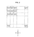
- Fig. 2 is used to explain the map data others that are recorded on the DVD disc 200 and that are stored in the map-data-storage unit 106.
- Fig. 2 is a drawing that explains the concept of the block as the unit used for dividing up the recorded and stored map data.
- map data which includes the road-shape data necessary for the navigation operation, as well as various related data such as related building data, place-name data and the like corresponding to the road-shape data, is recorded on the DVD disc 200.
- the entire map is divided into mesh-shaped blocks as unit areas, and the map data corresponding to each block is recorded as block map data.
- the block (i, j) is defined as the ith block from the West and the jth block from the North, and the all of the map data is configured with identical shaped blocks from block (1, 1) in the Northwest corner to block (M, N) in the Southeast comer.
- the entire map is explained as a rectangular-shaped area with each of the blocks also being rectangular shaped.
- a map having a complex shape may be used, and so the shapes of the blocks are not limited to being identical, and the scale of each block map data is also not limited to being identical.
- the blocks each have the identical rectangular shape in order to simplify the explanation of this embodiment. However, it is also possible to apply the invention to more complicated block shapes.
- Fig. 3 to Fig. 6 will be used to explain the transfer control by the system-control unit 115 of this embodiment.
- Fig. 3 will be used to explain the theory of the transfer control by the system-control unit 115 of this embodiment.
- Fig. 3 is a drawing for explaining the transfer control by the system-control unit 115 of this embodiment.
- the system-control unit 115 When the user enters a destination and sets the route, the system-control unit 115 performs control such that the map data recorded on the DVD disc 200 that is mounted in the DVD disc drive 105 is transferred to the map-data-storage unit 106 based on the transfer conditions such as the set route, current position of the automobile and characteristics of the set route, before route guidance begins.
- the navigation apparatus 100 of this embodiment is able to perform route guidance even though the DVD disc 200 having the map data may be removed during route guidance.
- the system-control unit 115 of this embodiment transfers the block map data having road set as the route (hereafter referred to as route-map-block data) and the block map data of the area surrounding the route-map-block data (hereafter called surrounding-map-block data) to the map-data-storage unit 106.
- route-map-block data the block map data having road set as the route
- surrounding-map-block data the block map data of the area surrounding the route-map-block data
- the system-control unit 115 determines the appropriateness of the transferred the surrounding-map-block data according to the characteristics of the set route, or in other words, sets a geographical range, and transfers the set surrounding-map-block data to the map-data-storage unit 106.
- the route must be changed due to ever-changing road conditions such as traffic jams or traffic accidents, or when the user suddenly changes or adds places to stop along the way. Therefore, in this case, the route must often be searched again and reset.
- the user when the DVD disc 200 on which the map data not having the road set as the original route is pre-recorded is not mounted in the DVD disc drive 105, the user must perform the troublesome operation of inserting the DVD disc 200 on which this block map data is recorded, or replace another optical disc with it.
- the system-control unit 115 performs the transfer operation for transferring the block map data whenever the route is reset, the amount of processing to be performed by the system-control unit 115 becomes excessively large. Additionally, it is not able to start guidance quickly. On the other hand, when the route is searched again and reset, the destination and the current position of the automobile do not change so the route is not greatly changed.
- the block map data which is foreseen that possibly containing the road is set as the route when the route is searched again and reset, is transferred in addition to the block map data containing the set route.
- the route-map-block data and the surrounding-map-block data are transferred to the map-data-storage unit 106 based on that set route.
- Fig. 3 shows a set route that includes normal roads, a freeway and automobile-only road (hereafter, called a freeway) and the geographical range of the route-map-block data and the surrounding-map-block data that are transferred based on that route. Furthermore, the Fig. 3 shows that more surrounding-map-block data near the entrances and exits of the freeway in the route and near the destination are transferred than that near other areas along the route.
- the block map data are transferred, however, since the current position of the automobile is displayed when the system is started, and the block-map data to be transferred is set, normally map data for the entire map that covers all of the block map data and that has a rougher scale than the block map data is stored in the ROM/RAM 116.
- the system-control unit 115 performs a data check of this map data for the entire map in order to prevent problems in transferring data.
- Fig. 4 to Fig. 9 will be used to explain the determination of the appropriateness of the surrounding-map-block data that are transferred in this embodiment.
- Fig. 4 and Fig. 5 are drawing for explaining the determination of the appropriateness of the surrounding-map-block data that is transferred in this embodiment
- Fig. 6 to Fig. 9 are examples of route-map-block data that are transferred by the transfer operation of this embodiment.
- the system-control unit 115 transfers the nine blocks of block map data, which surround the route-map-block data that has the road set as the route, as surrounding-map-block data. Furthermore, the system-control unit 115 determines whether to increase or decrease the amount of surrounding-map-block data that surrounds the route-map-block data based on the transfer conditions.
- the system-control unit 115 increases the amount of the surrounding-map-block data to be transferred based on the route-map-block data.
- the system-control unit 115 increases the number of blocks of the surrounding-map-block data around the route-map-block data from normal 9 to 25.
- the system-control unit 115 decreases the amount of the surrounding-map-block data to be transferred based on the route-map-block data.
- the system-control unit 115 decreases the normal number of blocks of surrounding-map-block data around the route-map-block data from normal 9 to just 3 blocks of surrounding-map-block data in the direction that the automobile travels.
- the surrounding-map-block data corresponding to the direction that the automobile travels along the route agrees with the route-map-block data when it judges on the whole block map data that is transferred. Therefore, so in actuality, the surrounding-map-block data is 2 blocks.
- the system-control unit 115 determines the amount of the block map data and the appropriateness of the surrounding-map-block data to be transferred based on the geographical range data that is pre-recorded in the block map data as the adjacent block map data that is always transferred when transferring the block map data.
- the system-control unit 115 reads control data belonging to the transferred block map data, and as described above, sets the block map data to be transferred based on the control data regardless of the appropriateness of the block map data to be transferred.
- the block map data has an indication to forcibly transfer other block map data when transferring any one of a plurality of blocks of block map data, or an indication to stop transferring surrounding block map data when it is determined that there is little possibility that the route will be reset due to past traveling conditions of the automobile, or when near the operators home is placed
- the system-control unit 115 of this embodiment transfers the block map data used for route guidance from the DVD disc 200 to the map-data-storage unit 106.
- the route-map-block data that is used for route guidance is not stored in the map-data-storage unit 106 in the case where the route from the current position to the destination is a long distance and the amount of the block map data for the entire set route exceeds data capacity that is normally stored in the map-data-storage unit 106 and cannot be stored in the map-data-storage unit 106, in the case where it is possible that a plurality of routes could be set and it is almost a certainty that the route will be searched again and the block map data for all of the set routes are not stored in the map-data-storage unit 106, or a case where it is not possible to transfer all of the map data necessary for route guidance by reproducing contents data on the DVD disc 200 after route guidance has started.
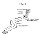
- the system-control unit 115 transfers the route-map-block data and the surrounding-map-block data (hereafter called route-map-block data others.) when the automobile begins traveling along the set route and travels for a pre-estimated amount of time. Then, as shown in Fig. 8, the system-control unit 115 repeats this operation until all of the route-map-block data for the route up to the destination has been transferred. Incidentally, the system-control unit 115 transfers the route-map-block data others, which belongs to the preset geographical range, having the road set as route toward the destination that had not yet been transferred.
- the system-control unit 115 transfers the block map data having the road set as the route up to the destination that have not yet been transferred as described above, the block map data that contains the part of the route that has already been passed is deleted.
- the system-control unit 115 waits for the DVD disc 200 to be inserted and then transfers the block map data.
- the system-control unit 115 waits for the DVD disc 200 to be inserted, and then as soon as the DVD disc 200 has been inserted it transfers the route-map-block data.
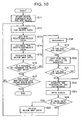
- Fig. 10 will be used to explain the operation of transferring the map data that is stored in the map-data-storage unit 106.
- Fig. 10 is a flowchart showing the operation of transferring the map data of this embodiment to the map-data-storage unit 106.
- the system-control unit 115 starts route guidance for the automobile based on the block map data having a place which indicates the starting position of the automobile (step S11).
- the system-control unit 115 acquires data of route for a preset range (hereafter referred to as route data) (step S12).
- the system-control unit 115 determines the setting range for the route data based on at least the current position of the automobile, the block map data showing the position of the automobile, and the scale of previously acquired block map data.
- the system-control unit 115 acquires the route data which is data of the road set as route belonging to the next route-map block data after the block map data currently is used for route guidance as the setting range.
- the system-control unit 115 sets the route-map-block data and the surrounding-map-block data as the route-map-block data based on the acquired route data (step S 13).
- the system-control unit 115 determines the block map data having the road set as the route as the route-map block data, and determines the surrounding-map-block data according to that the route-map-block data and the transfer conditions mentioned above.
- the system-control unit 115 determines ID numbers (hereafter referred to as the block IDs) for the route-map-block data and the nine blocks of the surrounding-map-block data around the route-map-block data, and in the case of the route-map-block data having the aforementioned transfer conditions, the system-control unit 115 increases or decreases the number of the block map data surrounding the route-map-block data based on those transfer conditions. Then, the system-control unit 115 determines the block IDs for the route-map-block data and the surrounding-map-block data.
- ID numbers hereafter referred to as the block IDs
- the system-control unit 115 judges the type of road set as the route, whether or not there are exits or entrances along the freeway set as the route, and whether or not the destination or stops along the way are included in that route-map-block data. Furthermore, the system-control unit 115 judges the amount of data in the route-map-block data and its the control data, the amount of data that can be stored in the map-data-storage unit 106, and whether or not the transferred route-map-block data is around the starting point. Then, the system-control unit 115 determines the block IDs for the surrounding-map-block data based on these judgments.
- the system-control unit 115 may also determine the surrounding-map-block data uniformly without judging the transfer conditions described above, and then determine block IDs for the block map data.
- the system-control unit 115 performs optimization of the set block IDs in the order corresponding to the order that the block map data are recorded on the DVD disc 200 (step S14).
- the system-control unit 115 optimizes a block of the block map data such that it is not transferred twice or more.
- system-control unit 115 rearranges the block IDs based on the order that the block map data is recorded on the DVD disc that contains the block map data to be transferred, and optimizes the process of acquiring the block map data.
- the block IDs are stored in ROM/RAM 116 according to that optimized order.
- the system-control unit 115 transfers the block map data from the DVD disc 200 to the map-data-storage unit 106 based on the optimized block IDs (step S15).
- the system-control unit 115 judges whether or not it is possible to still store block map data in the map-data-storage unit 106 (step S 16).
- the system-control unit 115 performs this judgment process.
- system-control unit 115 judges whether or not all of the transferred block map data can be store into the map-data-storage unit 106, or whether or not the DVD disc 200, on which the route-map-block data is recorded, is removed by the user during the process of transferring the route-map-block data.
- the system-control unit 115 judges that the block map data can still be stored in the map-data-storage unit 106, the system-control unit 115 then further judges whether or not all of the route-map-block data can be transferred (step S17), and when it is judges that all of the route-map-block data is transferred, the system-control unit 115 ends the transfer operation.
- the system-control unit 115 judges whether or not all of the block map data for the route is transferred.
- the system-control unit 115 After the system-control unit 115 judges that all of the route-map-block data is transferred and ends the transfer operation, the system-control unit 115 controls each unit to continue with performing route guidance based on the transferred route-map-block data.
- the system-control unit 115 judges that the block map data cannot all be stored in the map-data-storage unit 106, the system-control unit 115 controls each unit and performs route guidance based on the transferred route-map-block data and surrounding-map-block data, and temporarily stops the transfer operation of block map data (step S 18), and after the automobile exceeds a preset time, such as a the travel time mentioned above, the system-control unit 115 performs the following operation.
- the system-control unit 115 judges whether or not the DVD disc 200, on which the block map data having the road set as the route is recorded, is mounted in the DVD disc drive 105 (step S19), and when it judges that the DVD disc 200 is not mounted, it prompts the user by way of the display unit 110 to insert the DVD disc 200, on which the block map data having the road set as the route is recorded, and waits for the DVD disc 200 to be inserted (step S20).
- the system-control unit 115 performs route guidance based on the route-map-block data already stored in the map-data-storage unit 106, however when use of the route-map-block data and others stored in the map-data-storage unit 106 ends, the system-control unit 115 temporarily stops the route-guidance process and waits for more data.
- step S21 the system-control unit 115 advances to the process of step S22 after the DVD disc 200 is inserted and the system-control unit 115 judges that the DVD disc 200 is inserted.
- stem-control unit 115 judges the DVD disc 200, on which the block map data having the road set as the route is recorded, is already mounted, the system-control unit 115 acquires the position of the automobile according to the movement data output from the GPS receiving unit 101 as described above (step S22).
- the system-control unit 115 checks the position of the automobile on the set route based on the acquired position of the automobile, and checks the data and amount of block map data stored in the map-data-storage unit 106 that is to be deleted (hereafter, this is simply referred to as a data check) (step S23).
- the system-control unit 115 then judges whether or not there is block map data stored in the map-data-storage unit 106 that is to be deleted (step S24), and when the system-control unit 115 judges that there is no block map data to be deleted, it returns to step S 12.
- step S25 when the system-control unit 115 judges that there is block map data to be deleted, the system-control unit 115 deletes that block map data (step S25), and the returns to step S12 and repeats the transfer process.
- step S16 when there is not enough space to transfer all of the route-map-block data to the map-data-storage unit 106, and the system-control unit 115 judges that there is not any block map data to be deleted, the system-control unit 115 advances to step S22 and acquires the position of the automobile according to the movement data output from the GPS receiving unit 101, and repeats the process until block map data that can be deleted is detected.
- the navigation apparatus 100 of this embodiment transfers the block map data having the road set as the route up to the destination that is not yet transferred after the automobile continues traveling along the set route and it travels for a pre-estimated amount of time.
- the navigation apparatus 100 waits for the DVD disc to be inserted, and as soon as the DVD disc 200 is inserted, the navigation apparatus 100 is able to perform route guidance.
- the navigation apparatus 100 comprises: a GPS receiving unit 101 and sensor unit 102 that acquire the current position of the automobile; a system-control unit 115 that reads at least map data that is recorded on a mounted DVD disc 200, registers the destination that is to be reached by the automobile and sets a route to the destination based on the acquired current position of the automobile, the registered destination and map data; and a map-data-storage unit 106 that stores map data for performing route guidance for the automobile based on the set route; and wherein the system-control unit 115 transfers map data, which has a preset geographical range that includes the set route based on the current position of the automobile and the set route, from the DVD disc 200 to the map-data-storage unit 106.
- the navigation apparatus having a player for reproducing a DVD disc 200, which is a portable recording medium containing map data, is capable of storing the map data used for route guidance in a map-data-storage unit 106 after the route is set. Therefore, the navigation apparatus 100 is capable of performing route guidance and displaying the current position of the automobile even when the DVD disc 200 on which the map data is recorded is replaced with another recording medium or is removed. Furthermore, the navigation apparatus 100 is inexpensive and compact.
- the system-control unit 115 determines a geographical range for transferring the map data based on preset transfer conditions, and transfers map data from the DVD disc 200 to the map-data-storage unit 106 based on the set geographical range.
- the system-control unit 115 when searching and resetting the route to the destination, the system-control unit 115 as a rule performs the operation based on block map data that is already stored in the map-data-storage unit 106.
- the transfer operation of this embodiment of transferring block map data is performed again from the beginning on the condition that the DVD disc 200, on which the block map data is recorded, is mounted in the DVD disc drive 105.
- the block map data is transferred by comparing the block map data set the block IDs with the block map data already stored in the map-data-storage unit 106. Therefore, it is possible to perform the high speed of the transfer process of transferring block map data.
- the described navigation apparatus 100 transfers the block map data from the DVD disc 200 to the map-data-storage unit 106.
- the navigation apparatus 100 performs the transfer operation by reading a program of transfer operation from the recording medium and performing the program by computer.
- step S18 of the transfer operation when transferring block map data the process is temporarily stopped and an operation after the intermediate process is performed after the automobile has traveled beyond a preset amount of time.
- route-map-block data in a case of transferring route-map data that is not transferred, it is possible to determine whether the route-map-block data in the preset geographical range from the starting point, or in other words, the route-map data stored last in the map-data-storage unit 106 is used, whether the amount of the route-map-block data and the surrounding-map-block data already used for route guidance reaches the preset amount of data, or whether or not there is route-map-block data for the current position of the automobile.
Landscapes
- Engineering & Computer Science (AREA)
- Radar, Positioning & Navigation (AREA)
- Remote Sensing (AREA)
- Automation & Control Theory (AREA)
- Physics & Mathematics (AREA)
- General Physics & Mathematics (AREA)
- Navigation (AREA)
- Traffic Control Systems (AREA)
- Instructional Devices (AREA)
Abstract
Description
Claims (9)
- A navigation apparatus (100) characterized in that said apparatus comprises:an acquisition device (101, 102) for acquiring the current position of a moving body;a registration device (107, 115) that is used when registering the destination to which said moving body is to reach;a reading device (105) in which a portable recording medium (200) on which map data is recorded is mounted and which reads at least the map data recorded on the portable recording medium (200);a setting device (115) for setting a route to said destination based on the acquired current position, the registered destination and the recorded map data;a memory device (106) for storing map data used route guidance for the moving body based on the set route; anda transfer device (115) for transferring the map data, which has a preset geographical range that includes the road set as the route, based on the current position of the moving body and the set route from said portable recording medium (200) to the memory device (106).
- The navigation apparatus (100) according to claim 1, wherein
said transfer device (115), when transferring the map data, sets a geographical range for the map data based on preset transfer conditions, and then transfers the map data from said portable recording medium (200) to said recording medium based on the set geographical range. - The navigation apparatus (100) according to claim 2, wherein
said transfer device (115) sets the geographical range of the map data with at least one of the amount of the map data and the route characteristics indicating the characteristics of the set route as the transfer condition. - The navigation apparatus (100) according to claim 3 wherein
said transfer device (115) sets the geographical range of the map data with the road characteristics, which includes at least one of the type of the set route, points along the way including preset conditions for the set route, and characteristics of district indicated by map data, as the transfer condition. - The navigation apparatus (100) according to any one of claims 1 to 4, in a case where the entire map is divided into a plurality of blocks, and the divided block map data is recorded on said portable recording medium (200), wherein
said transfer device (115) transfers the plurality of blocks of block map data recorded on said portable recording medium (200) to said memory device (106) in block units based on the geographical range of the map data. - A navigation map data acquisition method characterized in that said method comprises:an acquisition step of acquiring the current position of a moving body;a registration step of registering the destination to which said moving body is to reach;a reading step of reading the map data recorded on a mounted portable recording medium (200); anda recording step of transferring the map data, which has a preset geographical range that includes the road set as the route, based on the current position of the moving body and the set route from said portable recording medium (200) to a memory device (106), and recording the transferred map data on said memory device (106) as the map data for using route guidance for the moving body based on the set route.
- The navigation map data acquisition method according to claim 6,
wherein
said recording step of setting a geographical range for the map data based on preset transfer conditions when transferring the map data, and then transferring the map data from said portable recording medium (200) to said recording medium based on the set geographical range. - A recording medium wherein a map data acquiring program is recorded so as to be read by a computer, the computer included in a navigation apparatus (100) for navigating a mobile body, characterized in that said program causes the computer to function as:an acquisition device (101, 102) for acquiring the current position of a moving body;a registration device (107, 115) for registering the destination to which said moving body is to reach;a reading device (105) for reading the map data recorded on a mounted portable recording medium (200); anda recording device (115) for transferring the map data, which has a preset geographical range that includes the road set as the route, based on the current position of the moving body and the set route from said portable recording medium (200) to a memory device (106), and recording the transferred map data on said memory device (106) as the map data for using route guidance for the moving body based on the set route.
- The recording medium according to claim 8, wherein the program further causes the computer to function as
said recording device (115) for setting a geographical range for the map data based on preset transfer conditions when transferring the map data, and then transferring the map data from said portable recording medium (200) to said recording medium based on the set geographical range.
Applications Claiming Priority (2)
| Application Number | Priority Date | Filing Date | Title |
|---|---|---|---|
| JP2003002325A JP3773902B2 (en) | 2003-01-08 | 2003-01-08 | Navigation device, navigation map data acquisition method, navigation map data acquisition program, and recording medium recording the same |
| JP2003002325 | 2003-01-08 |
Publications (2)
| Publication Number | Publication Date |
|---|---|
| EP1437572A2 true EP1437572A2 (en) | 2004-07-14 |
| EP1437572A3 EP1437572A3 (en) | 2007-10-03 |
Family
ID=32501210
Family Applications (1)
| Application Number | Title | Priority Date | Filing Date |
|---|---|---|---|
| EP04000168A Withdrawn EP1437572A3 (en) | 2003-01-08 | 2004-01-07 | Navigation apparatus, method and program |
Country Status (4)
| Country | Link |
|---|---|
| US (1) | US20040143388A1 (en) |
| EP (1) | EP1437572A3 (en) |
| JP (1) | JP3773902B2 (en) |
| CN (1) | CN1517679A (en) |
Families Citing this family (16)
| Publication number | Priority date | Publication date | Assignee | Title |
|---|---|---|---|---|
| GB0405795D0 (en) * | 2004-03-15 | 2004-04-21 | Tom Tom B V | Navigation device displaying travel information |
| JP4862276B2 (en) * | 2005-03-31 | 2012-01-25 | 株式会社デンソー | Map display device |
| JP2007163416A (en) * | 2005-12-16 | 2007-06-28 | Denso Corp | Navigation device |
| CN101169326B (en) * | 2006-10-25 | 2011-02-09 | 高德软件有限公司 | Additional vehicle line voice guiding device |
| US8224283B2 (en) * | 2008-06-13 | 2012-07-17 | Qualcomm Incorporated | FM band availability based on GPS |
| US9880014B2 (en) * | 2010-11-24 | 2018-01-30 | Telenav, Inc. | Navigation system with session transfer mechanism and method of operation thereof |
| KR101822622B1 (en) * | 2011-12-12 | 2018-01-26 | 현대엠엔소프트 주식회사 | Method and User Terminal for link between in-door path and out-door path |
| US9690334B2 (en) | 2012-08-22 | 2017-06-27 | Intel Corporation | Adaptive visual output based on change in distance of a mobile device to a user |
| US20140055339A1 (en) * | 2012-08-22 | 2014-02-27 | David Stanasolovich | Adaptive visual output based on motion compensation of a mobile device |
| KR102193378B1 (en) * | 2014-04-14 | 2020-12-22 | 팅크웨어(주) | Method and system for automatically detecting control section |
| US9593956B2 (en) * | 2014-04-14 | 2017-03-14 | Thinkware Corporation | Method and system for automatically detecting control section |
| CN103943026B (en) * | 2014-04-24 | 2016-02-24 | 深圳市赛速科技有限公司 | A kind of impact point automatic placement method based on pixel distance |
| KR102339130B1 (en) * | 2014-07-17 | 2021-12-15 | 팅크웨어(주) | Method and system for automatically detecting control section |
| JP7281707B2 (en) * | 2018-07-06 | 2023-05-26 | パナソニックIpマネジメント株式会社 | Mobile robot and control method |
| JP2022113054A (en) * | 2021-01-22 | 2022-08-03 | ソニーグループ株式会社 | Information processing device, information processing method, program, and moving device |
| CN113280827A (en) * | 2021-05-14 | 2021-08-20 | 北京福田戴姆勒汽车有限公司 | Vehicle positioning navigation system, vehicle and vehicle positioning navigation method |
Family Cites Families (16)
| Publication number | Priority date | Publication date | Assignee | Title |
|---|---|---|---|---|
| DE69526825T2 (en) * | 1994-09-08 | 2002-11-07 | Matsushita Electric Industrial Co., Ltd. | Method and system for route selection |
| DE69631458T2 (en) * | 1995-10-04 | 2004-07-22 | Aisin AW Co., Ltd., Anjo | Car navigation system |
| KR970002795A (en) * | 1995-10-30 | 1997-01-28 | 모리 하루오 | Navigation device |
| KR100267543B1 (en) * | 1996-04-28 | 2000-10-16 | 모리 하루오 | Processing device of road information or intersection information |
| JPH1165435A (en) * | 1997-08-21 | 1999-03-05 | Toyota Motor Corp | Map data processing device for vehicles |
| JPH1165436A (en) * | 1997-08-21 | 1999-03-05 | Toyota Motor Corp | Map data selection support device, map data processing system and processing device including the support device |
| DE69926283T2 (en) * | 1998-03-10 | 2006-03-30 | Matsushita Electric Industrial Co., Ltd., Kadoma | Reproducing apparatus, recording apparatus and recording / reproducing apparatus |
| JP4117971B2 (en) * | 1999-04-30 | 2008-07-16 | 本田技研工業株式会社 | Map information display system for moving objects |
| EP1098172A3 (en) * | 1999-11-08 | 2004-12-22 | Pioneer Corporation | Navigation system |
| JP4080123B2 (en) * | 1999-12-07 | 2008-04-23 | パイオニア株式会社 | Navigation system |
| JP2001165671A (en) * | 1999-12-14 | 2001-06-22 | Pioneer Electronic Corp | Navigation system |
| DE10029198A1 (en) * | 2000-06-19 | 2001-12-20 | Bosch Gmbh Robert | Selecting map information for navigation device involves starting from defined polygonal course on digital map; selected map information also contains parameter-dependent route corridor |
| JP4065108B2 (en) * | 2001-04-06 | 2008-03-19 | 三菱電機株式会社 | Vehicle navigation device |
| TWI240864B (en) * | 2001-06-13 | 2005-10-01 | Hitachi Ltd | Memory device |
| JP2003050774A (en) * | 2001-08-08 | 2003-02-21 | Matsushita Electric Ind Co Ltd | Data processing device and data transfer method |
| JP2003122622A (en) * | 2001-10-09 | 2003-04-25 | Honda Motor Co Ltd | Vehicle control device for controlling reception and writing of data |
-
2003
- 2003-01-08 JP JP2003002325A patent/JP3773902B2/en not_active Expired - Fee Related
-
2004
- 2004-01-05 US US10/750,957 patent/US20040143388A1/en not_active Abandoned
- 2004-01-07 EP EP04000168A patent/EP1437572A3/en not_active Withdrawn
- 2004-01-08 CN CNA200410001480XA patent/CN1517679A/en active Pending
Also Published As
| Publication number | Publication date |
|---|---|
| JP3773902B2 (en) | 2006-05-10 |
| US20040143388A1 (en) | 2004-07-22 |
| JP2004212340A (en) | 2004-07-29 |
| CN1517679A (en) | 2004-08-04 |
| EP1437572A3 (en) | 2007-10-03 |
Similar Documents
| Publication | Publication Date | Title |
|---|---|---|
| US6314369B1 (en) | Communications navigation system, and navigation base apparatus and navigation apparatus both used in the navigation system | |
| JP4539776B2 (en) | Information center and information processing method | |
| JP3814992B2 (en) | Vehicle navigation device | |
| EP1437572A2 (en) | Navigation apparatus, method and program | |
| JP4108291B2 (en) | Mobile object navigation apparatus and mobile object navigation method | |
| EP2126515B1 (en) | Route shaping systems and methods | |
| US20110029228A1 (en) | Map information delivery system, method, and program | |
| JP2003075171A (en) | Navigation device, electronic map display system, electronic map display method in navigation device, and program | |
| JP2009014731A (en) | Navigation method and navigation apparatus | |
| JPWO2005101350A1 (en) | MAP DRAWING DEVICE, NAVIGATION DEVICE, FILE UPDATE METHOD, FILE UPDATE PROGRAM, AND INFORMATION RECORDING MEDIUM CONTAINING THE FILE UPDATE PROGRAM | |
| JP7456714B2 (en) | In-vehicle system | |
| EP2259025A2 (en) | Navigation System, Method for Guidance along Guide Route, and Route Guidance Program | |
| US20060149467A1 (en) | Map drawing method, map drawing system, navigation apparatus and input/output apparatus | |
| JP3402287B2 (en) | Navigation method, center device, navigation system | |
| JP2004177199A (en) | Car navigation device, car navigation method, program and recording medium | |
| JP4531271B2 (en) | Navigation method, route providing device, route guidance device, and system | |
| JP4778171B2 (en) | Communication type navigation device and server device | |
| JP4312093B2 (en) | Navigation device, navigation method, and navigation program | |
| JPH10267683A (en) | Navigation device | |
| JP2003315075A (en) | System, method, and computer program for route search | |
| JP2002323340A (en) | Peripheral facility information providing device and program for peripheral facility information providing method | |
| JP4066134B2 (en) | Communication navigation system | |
| JP2006119056A (en) | In-vehicle navigation device and direction name display method thereof | |
| JP2000310543A (en) | Car navigation system | |
| JP2002139327A (en) | Navigation apparatus, mark-compatible operation attribute registration method, and operation execution method in navigation apparatus |
Legal Events
| Date | Code | Title | Description |
|---|---|---|---|
| PUAI | Public reference made under article 153(3) epc to a published international application that has entered the european phase |
Free format text: ORIGINAL CODE: 0009012 |
|
| AK | Designated contracting states |
Kind code of ref document: A2 Designated state(s): AT BE BG CH CY CZ DE DK EE ES FI FR GB GR HU IE IT LI LU MC NL PT RO SE SI SK TR |
|
| AX | Request for extension of the european patent |
Extension state: AL LT LV MK |
|
| RIN1 | Information on inventor provided before grant (corrected) |
Inventor name: ITO, HIROAKI,PIONEER CORP., HEAD OFFICE Inventor name: HOMMA, YASUHIDE,PIONEER CORP., KAWAGOE WORKS Inventor name: HIJIKATA, MAKOTO,PIONEER CORP., KAWAGOE WORKS Inventor name: OOUE, HIROSHI,PIONEER CORP., KAWAGOE WORKS Inventor name: MORIYA, NAMI,PIONEER CORP., KAWAGOE WORKS Inventor name: HAYASHIDA, TOMOKO,PIONEER CORP., KAWAGOE WORKS Inventor name: YANO, KENICHIRO,PIONEER CORP., HEAD OFFICE |
|
| PUAL | Search report despatched |
Free format text: ORIGINAL CODE: 0009013 |
|
| AK | Designated contracting states |
Kind code of ref document: A3 Designated state(s): AT BE BG CH CY CZ DE DK EE ES FI FR GB GR HU IE IT LI LU MC NL PT RO SE SI SK TR |
|
| AX | Request for extension of the european patent |
Extension state: AL LT LV MK |
|
| AKX | Designation fees paid | ||
| STAA | Information on the status of an ep patent application or granted ep patent |
Free format text: STATUS: THE APPLICATION IS DEEMED TO BE WITHDRAWN |
|
| 18D | Application deemed to be withdrawn |
Effective date: 20080404 |
|
| REG | Reference to a national code |
Ref country code: DE Ref legal event code: 8566 |