EP1362220B1 - Verfahren zum übertragen von routendaten - Google Patents
Verfahren zum übertragen von routendaten Download PDFInfo
- Publication number
- EP1362220B1 EP1362220B1 EP02712742A EP02712742A EP1362220B1 EP 1362220 B1 EP1362220 B1 EP 1362220B1 EP 02712742 A EP02712742 A EP 02712742A EP 02712742 A EP02712742 A EP 02712742A EP 1362220 B1 EP1362220 B1 EP 1362220B1
- Authority
- EP
- European Patent Office
- Prior art keywords
- data
- waypoint
- route
- turn
- corridor
- Prior art date
- Legal status (The legal status is an assumption and is not a legal conclusion. Google has not performed a legal analysis and makes no representation as to the accuracy of the status listed.)
- Expired - Lifetime
Links
- 238000000034 method Methods 0.000 title claims abstract description 40
- 230000005540 biological transmission Effects 0.000 description 12
- 206010021703 Indifference Diseases 0.000 description 4
- 239000007787 solid Substances 0.000 description 3
- 241001136792 Alle Species 0.000 description 1
- 238000010586 diagram Methods 0.000 description 1
- 238000012986 modification Methods 0.000 description 1
- 230000004048 modification Effects 0.000 description 1
- 230000003287 optical effect Effects 0.000 description 1
- 230000002123 temporal effect Effects 0.000 description 1
Images



Classifications
-
- G—PHYSICS
- G01—MEASURING; TESTING
- G01C—MEASURING DISTANCES, LEVELS OR BEARINGS; SURVEYING; NAVIGATION; GYROSCOPIC INSTRUMENTS; PHOTOGRAMMETRY OR VIDEOGRAMMETRY
- G01C21/00—Navigation; Navigational instruments not provided for in groups G01C1/00 - G01C19/00
- G01C21/26—Navigation; Navigational instruments not provided for in groups G01C1/00 - G01C19/00 specially adapted for navigation in a road network
- G01C21/34—Route searching; Route guidance
- G01C21/3407—Route searching; Route guidance specially adapted for specific applications
- G01C21/3415—Dynamic re-routing, e.g. recalculating the route when the user deviates from calculated route or after detecting real-time traffic data or accidents
Definitions
- the present invention relates to a method for transmitting at least route data from a center to a terminal, in particular to a car navigation device, the route data relating to at least one route corridor having a route corridor start point and a route corridor destination point.
- route data is particularly necessary in connection with so-called off-board vehicle navigation devices, in which the vehicle navigation device itself does not have sufficient data base to calculate routes and / or to verify waypoints.
- the route data is not complete in the sense of turn-by-turn navigation.
- Another problem often is that the storage of the route data often requires a relatively large amount of space.
- the route data comprise waypoint data relating to waypoints which lie between the route corridor start point and the route corridor destination point, two adjacent waypoints being connected by a route and the route corridor start point and the route corridor destination point also forming a respective waypoint
- the waypoint data includes, in addition to the attributes of the corresponding waypoint, attributes of paths branching from the corresponding waypoint
- an encoding method is provided whereby route information is efficiently and flexibly optimizable from a central office or server to a terminal can.
- the route data transmitted by the method according to the invention it is possible, for example, to perform a turn-by-turn navigation.
- the route data can be transmitted optimized memory and / or stored in the terminal.
- the method according to the invention makes it possible to transmit individual branches and / or entire alternative routes in addition to the main route.
- the individual waypoints of a route corridor are linked to one another in such a way that the smallest possible volume of data is generated and the order of transmission of the waypoint data is flexible. Due to the optimized order of transmission of the waypoint data a route guidance is possible even after receiving a small subset of the route data on the terminal.
- route data prior to the transmission of the route data metadata are transmitted which indicate which data format the waypoint data have and which information they contain. Following the transmission of the metadata, the route data can then be transmitted, for example, in the form of sequential waypoint data.
- the waypoint data is transmitted sequentially.
- the waypoint data for waypoints located at the beginning of the route corridor are transmitted first. This makes it possible to enable the route guidance after receiving a small subset of the route data on the terminal.
- the waypoint data preferably includes a waypoint data field for the coordinates of the waypoint.
- the coordinates of the waypoints are among the information that is usually indispensable for route guidance.
- the method according to the invention preferably provides that the waypoint data has a waypoint data header or header indicating whether the respective waypoint data has optional waypoint data fields.
- a waypoint data head it can be determined, for example, whether the waypoint is an edge point, whether an explicit successor is specified for the waypoint, if a street name is present, if there is a graphical route guidance indication, if there is an audible guidance indication, Whether there is a first reserved data field, if there is a second reserved data field or if branches exist.
- About the waypoint data head can preferably only be determined whether such information for the current waypoint at all or not, while the actual information is housed in specially provided data fields.
- the waypoint data head has the form of a bit field.
- the waypoint header may similarly indicate whether data is contained in the corresponding data fields.
- a waypoint data header can be dispensed with, since the data fields in this case can also be checked directly for their content.
- the number of waypoints may be, for example, the number of waypoints that are transmitted consecutively without specifying a waypoint number. It is also possible to transmit the number of waypoints for a partial route or a whole route.
- the method according to the invention preferably further provides that only the optional waypoint data fields whose content changes with respect to the previous waypoint are provided for a waypoint.
- the individual waypoints of the route corridor to be transmitted in the method according to the invention are preferably linked together in such a way that the smallest possible data volume is generated.
- the next waypoint is defined by the next transmitted waypoint data if the waypoint data contains no information regarding the next waypoint or the following waypoint.
- this list preferably has a data field for the number of branches contained in the list.
- the method according to the invention preferably further provides that the list of false branches for each branch comprises branch data having at least one branch data field for the waypoint data header and one branch data field for the successor number.
- the identification of the successor waypoint within the alternative route is usually required for the branches since more than one branch is possible per waypoint and consequently the waypoint data can not be transmitted immediately afterwards.
- the branch data fields are provided whose content changes with respect to the preceding branch.
- the route data has a fixed data format. For example, all of the optional data fields mentioned can always be provided. In this case, if necessary, a waypoint data header can be dispensed with. In this case, there is a rigid data format in which the information is entered at predetermined positions. If the corresponding data are not used, the corresponding data fields are unused.
- the route data has a flexible data format.
- the information is preferably characterized by being identified by prefixing meta-information.
- the data format in this case is more flexible and does not transmit unnecessary information and consequently does not store any unnecessary information.
- each such piece of information requires more memory in such embodiments of the method according to the invention since it must be preceded by an identifier in the form of metadata and / or waypoint data headers.
- FIG. 1 1 shows the mutual location of waypoints 1, 2, 3, 4, 5, 6 of a main route of a route corridor, where the route corridor start point is the waypoint 1, while the route corridor destination point is the waypoint 6.
- a first alternative route runs via a branch from waypoint 2 via waypoints 7, 8 to waypoint 4 of the main route.
- the route corridor in the case shown consists of the waypoints 1-10 and directional connections between the waypoints 1-10, as indicated by the solid arrows in FIG FIG. 1 is shown.
- the wrong or alternative branches are in FIG. 1 represented by dashed arrows.
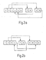
- FIG. 2a shows a first possibility for optimized transmission of route data for the route according to FIG. 1 .
- the waypoint data for waypoints 1-6 are transmitted.
- the waypoint data for the waypoints 7, 8 of the first alternative route are transmitted.
- the waypoint data for the waypoint 8 Contain a waypoint data field with information for the following waypoint, which is formed in this case by the waypoint 4, as shown in FIG.
- FIG. 2a is indicated by a solid arrow.
- the waypoint data for the waypoints 9, 10 are transmitted, the waypoint data for the waypoint 10 again containing a waypoint data field indicating the following waypoint, in this case the waypoint 5.
- FIG. 2a thus, it can be seen that only two explicit links of successors are required.
- the waypoint data includes optional waypoint data fields with which further information, such as the street name and so on, is transmitted.
- FIG. 2b shows a second possibility for optimized transmission of route data for the route according to FIG. 1 , In this second option, the waypoint data for the waypoints 1-4 are first transmitted, the waypoint data of the waypoint 4 containing a data field which determines the waypoint 5 as a successor.
- FIG. 3 Figure 11 is a diagram illustrating examples of meta-information, with the contents of the corresponding fields shown in Table 1 below.
- Table 1 field content 20 meta 21 language ID 22 country code 23 Used character set 24 Reference system (units) 25 The left / right? 26th Travel time or road class for each route section available? 27 Length of each route piece available? 28 Used coordinate coding 29 Coding the waypoint number (eg 16 or 32 bits) 30 Coding of the routing ID (eg 16 or 32 bits) 31 if necessary, remaining time and remaining distance to the destination 40 route data
- the temporal data transmission takes place according to the representation of FIG. 3 from left to right, that is, first the metadata 20 and then the route data 40 are transmitted.
- FIG. 4 shows a representation illustrating a possible data structure for the route data, wherein the contents of the corresponding fields from the following Table 2 results.
- the route data are structured such that in a data field 41, first the number of Zielwegtens is transmitted, followed by the number of nodes n k , which is transmitted in the data field 42.
- the waypoint data for the waypoints 1 to n k are sequentially connected to this information.
- the term data field within this application is used in such a way that a data field may well comprise further data fields or structured data fields.
- FIG. 4 the content of the data field 44 is shown in more detail.
- the waypoint data for waypoint 2 shown includes data fields 50-60. In the illustrated embodiment, data fields 50 and 51 are present for each waypoint, while data fields 52-60 are optional waypoint data fields.
- the data field 50 is a waypoint data header 50 indicating whether the respective waypoint data has optional waypoint data fields 52-60.
- the waypoint data header 50 is provided in the form of a bit field in which corresponding flags may be set, which may, for example, contain information about whether the current waypoint is a boundary point (61), whether an explicit successor is given (62), whether the street name exists (63), whether there is a graphical guidance hint (64), whether there is an audible guidance indication (65), whether a first there is a reserved data field (66), whether there is a second reserved data field (67) or if branches are present (68).
- the waypoint data header 50 may be provided, for example, such that a respective "1" indicates that the corresponding information is present in the waypoint data, while a "0" indicates that the corresponding information is not included in the current waypoint data.
- the method according to the invention preferably provides that the optional path data fields are only provided or filled with data if the corresponding data has changed in comparison with the previous waypoint.
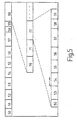
- FIG. 5 shows a representation that illustrates a possible data format for the list of false branches, with the respective contents of the corresponding.Felder from the following Table 3 results.
- FIG. 5 a possible structure for the list of wrong branches can be found.
- a data field 70 contains the number of branches n a , wherein the branch data for a corresponding branch in the branch data fields 71, 72, ... are included.
- a branch data field 71, 72 always contains a waypoint data header 50 and indications that identify the follower point, for example the successor number.
- the data fields 54-59 are again optionally provided.
- FIG. 3 shows information which can be supplied to the waypoint data for a more accurate specification.
- these include, for example, such information as in FIG. 3 are shown.
- the route consists of at least one sequence of coordinates, in which the route corridor destination and possible route alternatives are identified ( FIG. 4 ).
- the number of the route corridor destination point and / or numbers of route alternatives can be identified as the identifier.
- Conceivable are further, optional additional information such as street names, acoustic and / or optical guidance hints or the like:
- Branches can be inserted into the list according to the same principle. However, in contrast to the main route, these usually require the identification of the following waypoints within the alternative routes, since more than one branch per waypoint is possible and therefore can not be transmitted directly afterwards ( FIG. 5 ).
Landscapes
- Engineering & Computer Science (AREA)
- Radar, Positioning & Navigation (AREA)
- Remote Sensing (AREA)
- Automation & Control Theory (AREA)
- Physics & Mathematics (AREA)
- General Physics & Mathematics (AREA)
- Navigation (AREA)
- Mobile Radio Communication Systems (AREA)
- Traffic Control Systems (AREA)
Applications Claiming Priority (3)
| Application Number | Priority Date | Filing Date | Title |
|---|---|---|---|
| DE10106502 | 2001-02-13 | ||
| DE2001106502 DE10106502A1 (de) | 2001-02-13 | 2001-02-13 | Verfahren zum Übertragen von Routendaten |
| PCT/DE2002/000401 WO2002065057A1 (de) | 2001-02-13 | 2002-02-05 | Verfahren zum übertragen von routendaten |
Publications (2)
| Publication Number | Publication Date |
|---|---|
| EP1362220A1 EP1362220A1 (de) | 2003-11-19 |
| EP1362220B1 true EP1362220B1 (de) | 2010-11-10 |
Family
ID=7673787
Family Applications (1)
| Application Number | Title | Priority Date | Filing Date |
|---|---|---|---|
| EP02712742A Expired - Lifetime EP1362220B1 (de) | 2001-02-13 | 2002-02-05 | Verfahren zum übertragen von routendaten |
Country Status (5)
| Country | Link |
|---|---|
| EP (1) | EP1362220B1 (es) |
| JP (1) | JP4200005B2 (es) |
| DE (2) | DE10106502A1 (es) |
| ES (1) | ES2355495T3 (es) |
| WO (1) | WO2002065057A1 (es) |
Families Citing this family (1)
| Publication number | Priority date | Publication date | Assignee | Title |
|---|---|---|---|---|
| ES2245245B1 (es) * | 2004-06-08 | 2007-02-16 | INSTITUTO NACIONAL DE TECNICA AEROESPACIAL "ESTEBAN TERRADAS" | Sistema y metodo de control de un vehiculo aereo no tripulado. |
Family Cites Families (2)
| Publication number | Priority date | Publication date | Assignee | Title |
|---|---|---|---|---|
| US5919245A (en) * | 1995-04-21 | 1999-07-06 | Xanavi Informatics Corporation | Map database apparatus |
| GB2335492B (en) * | 1998-03-18 | 2002-02-27 | Nokia Mobile Phones Ltd | Local navigation alternatives |
-
2001
- 2001-02-13 DE DE2001106502 patent/DE10106502A1/de not_active Withdrawn
-
2002
- 2002-02-05 WO PCT/DE2002/000401 patent/WO2002065057A1/de not_active Ceased
- 2002-02-05 DE DE50214762T patent/DE50214762D1/de not_active Expired - Lifetime
- 2002-02-05 ES ES02712742T patent/ES2355495T3/es not_active Expired - Lifetime
- 2002-02-05 JP JP2002564329A patent/JP4200005B2/ja not_active Expired - Fee Related
- 2002-02-05 EP EP02712742A patent/EP1362220B1/de not_active Expired - Lifetime
Also Published As
| Publication number | Publication date |
|---|---|
| EP1362220A1 (de) | 2003-11-19 |
| JP2004518147A (ja) | 2004-06-17 |
| ES2355495T3 (es) | 2011-03-28 |
| JP4200005B2 (ja) | 2008-12-24 |
| DE10106502A1 (de) | 2002-08-29 |
| DE50214762D1 (de) | 2010-12-23 |
| WO2002065057A1 (de) | 2002-08-22 |
Similar Documents
| Publication | Publication Date | Title |
|---|---|---|
| DE69123199T2 (de) | Verfahren zur Ortsbestimmung eines Fahrzeuges, Anordnung zur Ortsbestimmung eines Fahrzeuges sowie Fahrzeug mit der Anordnung | |
| DE3882686T2 (de) | Vorbereitungssystem von knotenserien des wegendes in einem navigationsgeraet. | |
| DE69715553T2 (de) | Navigationssystem | |
| DE3851604T2 (de) | Navigationseinrichtung, die auf einem System zur Berechnung der gegenwärtigen Position beruht. | |
| DE69719694T2 (de) | Wegsuchgerät | |
| DE112008000874B4 (de) | Karteninformationsverarbeitungsvorrichtung | |
| EP2507589B1 (de) | Verfahren zur vereinfachung einer beschreibung einer fahrtroute | |
| DE10162359A1 (de) | Verfahren zu Bereitstellung von Routendaten für ein Navigationsverfahren | |
| DE10031535B4 (de) | Karteninformationsanzeigeeinrichtung für einen sich bewegenden Körper und Verfahren zur Anzeige von Karteninformation für einen sich bewegenden Körper | |
| DE102004040381A1 (de) | Karteninformations-Verarbeitungsgerät, Kartenaktualisierungs-Informationsspeichermedium, Kartenaktualisierungs-Informationsdatenstruktur, Kartenaktualisierungs -Informations- und Erzeugungssystem und Karteninformations-Aktualisierungssystem | |
| EP1224645A1 (de) | Verfahren zur codierung und decodierung von objekten in einem verkehrswegenetz | |
| DE19842430A1 (de) | Kartendatenverarbeitungsvorrichtung und -verfahren, und Kartendatenverarbeitungssystem | |
| DE4405771A1 (de) | Navigationssystem mit einem Routenbestimmungsverfahren zum schnellen und genauen Bestimmen einer gewünschten Route | |
| EP3472820B1 (de) | Aktualisierung einer digitalen karte | |
| DE10137632A1 (de) | Verfahren und System zum Auffinden eines Ortes in einer digitalen Karte | |
| DE10204490A1 (de) | Navigationssystem für Fahrzeuge | |
| WO1998017040A1 (de) | Verfahren und einrichtung zum datenaustausch zwischen einer zentralen einheit und einer datenendeinrichtung | |
| EP1362220B1 (de) | Verfahren zum übertragen von routendaten | |
| EP1136791A1 (de) | Verfahren und Vorrichtung zur Darstellung eines geografischen Bildes auf einem Bildschirm | |
| EP1092950A1 (de) | Verfahren zur Bestimmung einer Fahrtroute für ein Strassenfahrzeug | |
| DE10113810A1 (de) | Verfahren und Navigationsvorrichtung zum Ermitteln einer optimalen Fahrtroute für ein Fahrzeug | |
| EP1122518B1 (de) | Verfahren zur Decodierung von linienförmigen geographischen Objekten | |
| DE3006141A1 (de) | Verfahren und vorrichtung zur wegweisung eines verkehrsteilnehmers, insbesondere eines kraftfahrzeuges | |
| DE10009149A1 (de) | Verfahren zur Codierung und Decodierung von Objekten in einem Verkehrswegenetz | |
| EP1979837B1 (de) | Verfahren zur ausgabe von datensätzen und vorrichtung hierfür |
Legal Events
| Date | Code | Title | Description |
|---|---|---|---|
| PUAI | Public reference made under article 153(3) epc to a published international application that has entered the european phase |
Free format text: ORIGINAL CODE: 0009012 |
|
| 17P | Request for examination filed |
Effective date: 20030915 |
|
| AK | Designated contracting states |
Kind code of ref document: A1 Designated state(s): AT BE CH CY DE DK ES FI FR GB GR IE IT LI LU MC NL PT SE TR |
|
| AX | Request for extension of the european patent |
Extension state: AL LT LV MK RO SI |
|
| RIN1 | Information on inventor provided before grant (corrected) |
Inventor name: SKWAREK, VOLKER Inventor name: BUECHER, ANDREAS Inventor name: FRIEDRICHS, ARNE Inventor name: DRAEGER, GERD |
|
| 17Q | First examination report despatched |
Effective date: 20080903 |
|
| GRAP | Despatch of communication of intention to grant a patent |
Free format text: ORIGINAL CODE: EPIDOSNIGR1 |
|
| GRAS | Grant fee paid |
Free format text: ORIGINAL CODE: EPIDOSNIGR3 |
|
| GRAA | (expected) grant |
Free format text: ORIGINAL CODE: 0009210 |
|
| AK | Designated contracting states |
Kind code of ref document: B1 Designated state(s): DE ES FR GB IT SE |
|
| REG | Reference to a national code |
Ref country code: GB Ref legal event code: FG4D Free format text: NOT ENGLISH |
|
| REF | Corresponds to: |
Ref document number: 50214762 Country of ref document: DE Date of ref document: 20101223 Kind code of ref document: P |
|
| REG | Reference to a national code |
Ref country code: SE Ref legal event code: TRGR |
|
| REG | Reference to a national code |
Ref country code: ES Ref legal event code: FG2A Ref document number: 2355495 Country of ref document: ES Kind code of ref document: T3 Effective date: 20110328 |
|
| PGFP | Annual fee paid to national office [announced via postgrant information from national office to epo] |
Ref country code: SE Payment date: 20110221 Year of fee payment: 10 |
|
| PGFP | Annual fee paid to national office [announced via postgrant information from national office to epo] |
Ref country code: ES Payment date: 20110221 Year of fee payment: 10 Ref country code: GB Payment date: 20110221 Year of fee payment: 10 |
|
| PLBE | No opposition filed within time limit |
Free format text: ORIGINAL CODE: 0009261 |
|
| STAA | Information on the status of an ep patent application or granted ep patent |
Free format text: STATUS: NO OPPOSITION FILED WITHIN TIME LIMIT |
|
| 26N | No opposition filed |
Effective date: 20110811 |
|
| REG | Reference to a national code |
Ref country code: DE Ref legal event code: R097 Ref document number: 50214762 Country of ref document: DE Effective date: 20110811 |
|
| GBPC | Gb: european patent ceased through non-payment of renewal fee |
Effective date: 20120205 |
|
| PG25 | Lapsed in a contracting state [announced via postgrant information from national office to epo] |
Ref country code: SE Free format text: LAPSE BECAUSE OF NON-PAYMENT OF DUE FEES Effective date: 20120206 |
|
| PG25 | Lapsed in a contracting state [announced via postgrant information from national office to epo] |
Ref country code: GB Free format text: LAPSE BECAUSE OF NON-PAYMENT OF DUE FEES Effective date: 20120205 |
|
| REG | Reference to a national code |
Ref country code: ES Ref legal event code: FD2A Effective date: 20130708 |
|
| PG25 | Lapsed in a contracting state [announced via postgrant information from national office to epo] |
Ref country code: ES Free format text: LAPSE BECAUSE OF NON-PAYMENT OF DUE FEES Effective date: 20120206 |
|
| REG | Reference to a national code |
Ref country code: FR Ref legal event code: PLFP Year of fee payment: 15 |
|
| REG | Reference to a national code |
Ref country code: FR Ref legal event code: PLFP Year of fee payment: 16 |
|
| PGFP | Annual fee paid to national office [announced via postgrant information from national office to epo] |
Ref country code: FR Payment date: 20170220 Year of fee payment: 16 |
|
| PGFP | Annual fee paid to national office [announced via postgrant information from national office to epo] |
Ref country code: IT Payment date: 20170217 Year of fee payment: 16 |
|
| PGFP | Annual fee paid to national office [announced via postgrant information from national office to epo] |
Ref country code: DE Payment date: 20180426 Year of fee payment: 17 |
|
| REG | Reference to a national code |
Ref country code: FR Ref legal event code: ST Effective date: 20181031 |
|
| PG25 | Lapsed in a contracting state [announced via postgrant information from national office to epo] |
Ref country code: FR Free format text: LAPSE BECAUSE OF NON-PAYMENT OF DUE FEES Effective date: 20180228 Ref country code: IT Free format text: LAPSE BECAUSE OF NON-PAYMENT OF DUE FEES Effective date: 20180205 |
|
| REG | Reference to a national code |
Ref country code: DE Ref legal event code: R119 Ref document number: 50214762 Country of ref document: DE |
|
| PG25 | Lapsed in a contracting state [announced via postgrant information from national office to epo] |
Ref country code: DE Free format text: LAPSE BECAUSE OF NON-PAYMENT OF DUE FEES Effective date: 20190903 |