EP1281816A2 - Excavator data acquisition and control system and process - Google Patents
Excavator data acquisition and control system and process Download PDFInfo
- Publication number
- EP1281816A2 EP1281816A2 EP02021968A EP02021968A EP1281816A2 EP 1281816 A2 EP1281816 A2 EP 1281816A2 EP 02021968 A EP02021968 A EP 02021968A EP 02021968 A EP02021968 A EP 02021968A EP 1281816 A2 EP1281816 A2 EP 1281816A2
- Authority
- EP
- European Patent Office
- Prior art keywords
- data
- utility
- location
- subsurface
- underground utility
- Prior art date
- Legal status (The legal status is an assumption and is not a legal conclusion. Google has not performed a legal analysis and makes no representation as to the accuracy of the status listed.)
- Granted
Links
Images


Classifications
-
- G—PHYSICS
- G01—MEASURING; TESTING
- G01V—GEOPHYSICS; GRAVITATIONAL MEASUREMENTS; DETECTING MASSES OR OBJECTS; TAGS
- G01V11/00—Prospecting or detecting by methods combining techniques covered by two or more of main groups G01V1/00 - G01V9/00
-
- E—FIXED CONSTRUCTIONS
- E02—HYDRAULIC ENGINEERING; FOUNDATIONS; SOIL SHIFTING
- E02F—DREDGING; SOIL-SHIFTING
- E02F5/00—Dredgers or soil-shifting machines for special purposes
- E02F5/02—Dredgers or soil-shifting machines for special purposes for digging trenches or ditches
- E02F5/06—Dredgers or soil-shifting machines for special purposes for digging trenches or ditches with digging elements mounted on an endless chain
-
- E—FIXED CONSTRUCTIONS
- E02—HYDRAULIC ENGINEERING; FOUNDATIONS; SOIL SHIFTING
- E02F—DREDGING; SOIL-SHIFTING
- E02F5/00—Dredgers or soil-shifting machines for special purposes
- E02F5/02—Dredgers or soil-shifting machines for special purposes for digging trenches or ditches
- E02F5/14—Component parts for trench excavators, e.g. indicating devices travelling gear chassis, supports, skids
- E02F5/145—Component parts for trench excavators, e.g. indicating devices travelling gear chassis, supports, skids control and indicating devices
-
- E—FIXED CONSTRUCTIONS
- E02—HYDRAULIC ENGINEERING; FOUNDATIONS; SOIL SHIFTING
- E02F—DREDGING; SOIL-SHIFTING
- E02F9/00—Component parts of dredgers or soil-shifting machines, not restricted to one of the kinds covered by groups E02F3/00 - E02F7/00
- E02F9/20—Drives; Control devices
- E02F9/2025—Particular purposes of control systems not otherwise provided for
- E02F9/2029—Controlling the position of implements in function of its load, e.g. modifying the attitude of implements in accordance to vehicle speed
-
- E—FIXED CONSTRUCTIONS
- E02—HYDRAULIC ENGINEERING; FOUNDATIONS; SOIL SHIFTING
- E02F—DREDGING; SOIL-SHIFTING
- E02F9/00—Component parts of dredgers or soil-shifting machines, not restricted to one of the kinds covered by groups E02F3/00 - E02F7/00
- E02F9/20—Drives; Control devices
- E02F9/2025—Particular purposes of control systems not otherwise provided for
- E02F9/2045—Guiding machines along a predetermined path
-
- E—FIXED CONSTRUCTIONS
- E02—HYDRAULIC ENGINEERING; FOUNDATIONS; SOIL SHIFTING
- E02F—DREDGING; SOIL-SHIFTING
- E02F9/00—Component parts of dredgers or soil-shifting machines, not restricted to one of the kinds covered by groups E02F3/00 - E02F7/00
- E02F9/26—Indicating devices
-
- E—FIXED CONSTRUCTIONS
- E02—HYDRAULIC ENGINEERING; FOUNDATIONS; SOIL SHIFTING
- E02F—DREDGING; SOIL-SHIFTING
- E02F9/00—Component parts of dredgers or soil-shifting machines, not restricted to one of the kinds covered by groups E02F3/00 - E02F7/00
- E02F9/26—Indicating devices
- E02F9/261—Surveying the work-site to be treated
- E02F9/262—Surveying the work-site to be treated with follow-up actions to control the work tool, e.g. controller
-
- E—FIXED CONSTRUCTIONS
- E21—EARTH OR ROCK DRILLING; MINING
- E21C—MINING OR QUARRYING
- E21C39/00—Devices for testing in situ the hardness or other properties of minerals, e.g. for giving information as to the selection of suitable mining tools
-
- G—PHYSICS
- G01—MEASURING; TESTING
- G01C—MEASURING DISTANCES, LEVELS OR BEARINGS; SURVEYING; NAVIGATION; GYROSCOPIC INSTRUMENTS; PHOTOGRAMMETRY OR VIDEOGRAMMETRY
- G01C15/00—Surveying instruments or accessories not provided for in groups G01C1/00 - G01C13/00
-
- G—PHYSICS
- G01—MEASURING; TESTING
- G01S—RADIO DIRECTION-FINDING; RADIO NAVIGATION; DETERMINING DISTANCE OR VELOCITY BY USE OF RADIO WAVES; LOCATING OR PRESENCE-DETECTING BY USE OF THE REFLECTION OR RERADIATION OF RADIO WAVES; ANALOGOUS ARRANGEMENTS USING OTHER WAVES
- G01S19/00—Satellite radio beacon positioning systems; Determining position, velocity or attitude using signals transmitted by such systems
- G01S19/01—Satellite radio beacon positioning systems transmitting time-stamped messages, e.g. GPS [Global Positioning System], GLONASS [Global Orbiting Navigation Satellite System] or GALILEO
- G01S19/13—Receivers
- G01S19/14—Receivers specially adapted for specific applications
-
- G—PHYSICS
- G01—MEASURING; TESTING
- G01S—RADIO DIRECTION-FINDING; RADIO NAVIGATION; DETERMINING DISTANCE OR VELOCITY BY USE OF RADIO WAVES; LOCATING OR PRESENCE-DETECTING BY USE OF THE REFLECTION OR RERADIATION OF RADIO WAVES; ANALOGOUS ARRANGEMENTS USING OTHER WAVES
- G01S19/00—Satellite radio beacon positioning systems; Determining position, velocity or attitude using signals transmitted by such systems
- G01S19/38—Determining a navigation solution using signals transmitted by a satellite radio beacon positioning system
- G01S19/39—Determining a navigation solution using signals transmitted by a satellite radio beacon positioning system the satellite radio beacon positioning system transmitting time-stamped messages, e.g. GPS [Global Positioning System], GLONASS [Global Orbiting Navigation Satellite System] or GALILEO
- G01S19/40—Correcting position, velocity or attitude
- G01S19/41—Differential correction, e.g. DGPS [differential GPS]
-
- G—PHYSICS
- G01—MEASURING; TESTING
- G01S—RADIO DIRECTION-FINDING; RADIO NAVIGATION; DETERMINING DISTANCE OR VELOCITY BY USE OF RADIO WAVES; LOCATING OR PRESENCE-DETECTING BY USE OF THE REFLECTION OR RERADIATION OF RADIO WAVES; ANALOGOUS ARRANGEMENTS USING OTHER WAVES
- G01S19/00—Satellite radio beacon positioning systems; Determining position, velocity or attitude using signals transmitted by such systems
- G01S19/38—Determining a navigation solution using signals transmitted by a satellite radio beacon positioning system
- G01S19/39—Determining a navigation solution using signals transmitted by a satellite radio beacon positioning system the satellite radio beacon positioning system transmitting time-stamped messages, e.g. GPS [Global Positioning System], GLONASS [Global Orbiting Navigation Satellite System] or GALILEO
- G01S19/42—Determining position
- G01S19/48—Determining position by combining or switching between position solutions derived from the satellite radio beacon positioning system and position solutions derived from a further system
-
- G—PHYSICS
- G01—MEASURING; TESTING
- G01V—GEOPHYSICS; GRAVITATIONAL MEASUREMENTS; DETECTING MASSES OR OBJECTS; TAGS
- G01V3/00—Electric or magnetic prospecting or detecting; Measuring magnetic field characteristics of the earth, e.g. declination, deviation
- G01V3/12—Electric or magnetic prospecting or detecting; Measuring magnetic field characteristics of the earth, e.g. declination, deviation operating with electromagnetic waves
-
- G—PHYSICS
- G01—MEASURING; TESTING
- G01V—GEOPHYSICS; GRAVITATIONAL MEASUREMENTS; DETECTING MASSES OR OBJECTS; TAGS
- G01V3/00—Electric or magnetic prospecting or detecting; Measuring magnetic field characteristics of the earth, e.g. declination, deviation
- G01V3/15—Electric or magnetic prospecting or detecting; Measuring magnetic field characteristics of the earth, e.g. declination, deviation specially adapted for use during transport, e.g. by a person, vehicle or boat
- G01V3/17—Electric or magnetic prospecting or detecting; Measuring magnetic field characteristics of the earth, e.g. declination, deviation specially adapted for use during transport, e.g. by a person, vehicle or boat operating with electromagnetic waves
-
- G—PHYSICS
- G01—MEASURING; TESTING
- G01S—RADIO DIRECTION-FINDING; RADIO NAVIGATION; DETERMINING DISTANCE OR VELOCITY BY USE OF RADIO WAVES; LOCATING OR PRESENCE-DETECTING BY USE OF THE REFLECTION OR RERADIATION OF RADIO WAVES; ANALOGOUS ARRANGEMENTS USING OTHER WAVES
- G01S13/00—Systems using the reflection or reradiation of radio waves, e.g. radar systems; Analogous systems using reflection or reradiation of waves whose nature or wavelength is irrelevant or unspecified
- G01S13/87—Combinations of radar systems, e.g. primary radar and secondary radar
- G01S13/876—Combination of several spaced transponders or reflectors of known location for determining the position of a receiver
-
- G—PHYSICS
- G01—MEASURING; TESTING
- G01S—RADIO DIRECTION-FINDING; RADIO NAVIGATION; DETERMINING DISTANCE OR VELOCITY BY USE OF RADIO WAVES; LOCATING OR PRESENCE-DETECTING BY USE OF THE REFLECTION OR RERADIATION OF RADIO WAVES; ANALOGOUS ARRANGEMENTS USING OTHER WAVES
- G01S13/00—Systems using the reflection or reradiation of radio waves, e.g. radar systems; Analogous systems using reflection or reradiation of waves whose nature or wavelength is irrelevant or unspecified
- G01S13/88—Radar or analogous systems specially adapted for specific applications
- G01S13/885—Radar or analogous systems specially adapted for specific applications for ground probing
-
- G—PHYSICS
- G01—MEASURING; TESTING
- G01S—RADIO DIRECTION-FINDING; RADIO NAVIGATION; DETERMINING DISTANCE OR VELOCITY BY USE OF RADIO WAVES; LOCATING OR PRESENCE-DETECTING BY USE OF THE REFLECTION OR RERADIATION OF RADIO WAVES; ANALOGOUS ARRANGEMENTS USING OTHER WAVES
- G01S5/00—Position-fixing by co-ordinating two or more direction or position line determinations; Position-fixing by co-ordinating two or more distance determinations
- G01S5/18—Position-fixing by co-ordinating two or more direction or position line determinations; Position-fixing by co-ordinating two or more distance determinations using ultrasonic, sonic or infrasonic waves
- G01S5/30—Determining absolute distances from a plurality of spaced points of known location
Definitions
- An initial survey may suggest that the subsurface geology for all or most of a predetermined excavation route consists mostly of sand or loose gravel.
- the contractor's budget and bid will, accordingly, reflect the costs associated with excavating relatively soft subsurface soil.
- a significant portion of the predetermined excavation route consists of relatively hard soil, such a granite, for example.
- the additional costs associated with excavating the undetected hard soil are typically borne by the contractor. It is generally appreciated in the excavation industry that such unforeseen costs can compromise the financial viability of a contractor's business.
- the geologic imaging system preferably includes a ground penetrating radar system having a plurality of antennas oriented in an orthogonal relationship to provide three-dimensional imaging of subsurface geology.
- Correlation software is employed to correlate acquired geologic image data to historical excavator productionperformance data to characterize the structural mechanics of subsurface geology.
- Accurate geographic mapping of an excavation site is provided by the geographic positioning system which preferably includes a mobile transponder mounted to an excavator and a plurality of ground-based transponders.
- signals transmitted by one or more Global Positioning System (GPS) satellites are utilized together with reference signals produced by a plurality of ground-based transponders.
- GPS Global Positioning System
- a track trencher represents only one of many embodiments of an excavator that may be equipped with a novel excavator data acquisition and control system as disclosed hereinbelow. As such, the advantages and features of the disclosed novel system and process are not limited to application in connection with a track trencher.
- Fig. 4 there is illustrated a novel data acquisition and control system shown in system block diagram form.
- the system shown in Fig. 4 significantly enhances the operation of an excavator by the acquisition of geological, geophysical, and position information regarding a particular excavation site, and by employing this information to enhance excavation efficiency.
- the acquisition of such pertinent excavation site data substantially reduces the risk involved in estimating the cost and scheduling of a particular excavation project.
- Real-time acquisition of geographical position data provides for precision mapping of an excavated area to accurately identify the location and depth of, for example, buried pipelines and utility conduits installed at the excavation site.
- the geophysical data acquisition unit 256 preferably includes a geologic imaging unit 258 and a geophysical characterization unit 260.
- the geophysical characterization unit 260 preferably includes a number of geophysical instruments which provide a physical characterization of the geology for a particular excavation site.
- a seismic mapping module 286 includes an electronic device consisting of multiple geophysical pressure sensors. A network of these sensors are arranged in a specific orientation with respect to the excavator, and are situated so as to make direct contact with the ground. The network of sensors measures ground pressure waves produced below the excavator and in the trench walls produced by the excavator. Analysis of ground pressure waves received by the network of sensors provides a basis for determining the physical characteristics of the subsurface at the excavation site. This data is preferably processed by the CPU 276 of the geophysical data acquisition unit 256 or, alternatively, by the CPU 264 of the main control unit 250.
- a point load tester 288 may be employed to determine the geophysical characteristics of the subsurface at the excavation site.
- the point load tester 288 preferably employs a plurality conical bits for the loading points which, in turn, are brought into contact with the ground to test the degree to which a particular subsurface can resist a calibrated level of loading.
- the data acquired by the point load tester 288 provides information corresponding to the geophysical mechanics of the soil under test. This data may also be transmitted to the geophysical data acquisition unit 256 for storage in the RAM 278 or EEPROM 280.
- the left and right track pumps 38 and 40 deriving power from the engine 36, preferably regulate oil flow to the left and right track motors 42 and 44 which, in turn, provide propulsion for the left and right track drives 34 and 32.
- the excavation attachment 46 preferably comprises an attachment motor 48 and an attachment control 98, with the attachment 46 preferably deriving power from the engine 36.
- a sensor 186 is preferably coupled to the attachment motor 46. Actuation of the left track motor 42, right track motor 44, and attachment motor 48 is monitored by sensors 198, 192, and 186 respectively. The output signals produced by the sensors 198, 192, and 186 are communicated to the computer 182.
- the computer 182 In response to steering and propel control signals respectively produced by the steering control 92 and propel control 90, the computer 182 communicates control signals, typically in the form of control current, to the left and right track pumps 38 and 40 which, in turn, regulate the speed at which the left and right track motors 42 and 44 operate.
- the left and right track motor sensors 198 and 192 communicate track motor sense signals to the computer 182 indicative of the actual speed of the left and right track motors 42 and 44.
- an engine sensor 208 coupled to the engine 36, provides an engine sense signal to the computer 182, thus completing a closed-loop control system for the tractor drive portion 45 of a track trencher 30.
- Those skilled in the art will recognize that various known computer configurations will provide a suitable platform for effectuating propulsion and steering changes of a track trencher 30 in response to the propel and steering signals produced by the propel and steering controls 90 and 92.
- a display 73 is coupled to the computer 182 or, alternatively, to the main control unit 250, and preferably communicates messages indicative of operating status, diagnostic, calibration, fault, safety, and other related information to an operator.
- the display 73 provides quick, accurate, and easy-to-understand information to an operator by virtue of the interpretive power of the computer 182 which acquires and processes data from a plurality of track trencher sensors, and various geological and geophysical instruments. Geologic imaging data and related geophysical information, for example, is visually displayed on the display 73. Further, information regarding the position of the excavator as it traverses along a predetermined excavation route, as well as signal quality information received from the geographic positioning unit 254, is displayed on the display 73.
- a keyboard 75 is also provided on the main user interface 101 to permit an operator to communicate with the excavator control unit 255 and the main control unit 250.
- a maintenance log memory 314 preferably includes non-volatile memory for storing various types of excavator maintenance information.
- An elapsed time indicator is preferably included in the maintenance log memory 314 which indicates the total elapsed operating time of the excavator.
- the excavator operator is prompted by the main user interface 101 that scheduled service is required. Verification of scheduled service, the type of service, the date of service, and other related information is preferably input through the main user interface 101 for permanent storage in the maintenance log memory 314.
- the maintenance log memory 314 preferably includes a table of factory designated operational values and ranges of operational values associated with nominal excavator operation.
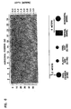
- various types of soil and subsurface structures are detected, such as a sand layer 354, gravel 352, bedrock 350, and native soil 348, each of which has a corresponding characteristic geologic profile and geologic filter profile.
- the data acquired and stored in the geophysic data acquisition unit 256 and geographic positioning unit 254 is preferably downloaded to a separate personal computer (PC) 252.
- the PC 252 preferably includes excavation statistics software and an associated database 316 to correlate the acquired survey data with historical excavator production performance data to produce an estimation as to expected excavator performance over the surveyed route.
- the performance estimates may further be used as a basis for computing the time and cost involved in excavating a particular area based on actual geological data and historical production performance data.
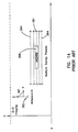
- Fig. 11 there is illustrated an example of a survey profile obtained by transporting the geophysic data acquisition unit 256 and geographic positioning unit 254 along a predetermined excavation route. It is noted that in this illustrative example, the length of the excavation route is defined as the distance between Location L 0 and Location L 5 . A corresponding estimated excavation production profile for the predetermined excavation route is shown in Fig. 12.
- Fig. 11 distinct changes in subsurface geological characteristics can be observed at locations L 1 , L 2 , L 3 , and L 4 , which are associated with corresponding changes in the "excavation difficulty" parameter plotted along the Y-axis of the survey profile chart.
- locations L 0 and L 1 for example, the geologic profile GP 1 362 of the subsurface has associated with it a corresponding excavation difficulty parameter of D 1 .
- the geologic imaging data at L 1 indicates a transition in the subsurface geology to soil having a geologic profile of GP 2 364 and a corresponding excavation difficulty parameter of D 2 , thus indicating a transition to relatively softer soil.
- the estimated excavation production profile data shown in Fig. 12 indicates a corresponding transition from an initial production profile PP 1 372 to another production profile PP 2 374 at location L 1 . It is noted that the rate of excavation is plotted along the Y-axis of the excavation production profile chart. Based on the survey profile data for the subsurface geological characteristics between locations L 0 and L 2 , it can be seen that an initial excavation rate R 1 is estimated for the portion of the predetermined excavation route between locations L 0 and L 1 , and an increased excavation rate of R 2 between excavation route locations L 1 and L 2 due to the lower excavation difficulty parameter D 2 associated with geologic profile GP 2 364. It can be seen that a similar relationship exists between a particular excavation difficulty parameter and its corresponding estimated excavation rate parameter.
- the survey profile data of Fig. 11 associated with geologic profile GP 4 368 between excavation route locations L 3 and L 4 indicates a discontinuity at this location.
- the excavation production profile data of Fig. 12 corresponding to this portion of the predetermined excavation route indicates a corresponding discontinuity in the excavation rate estimation which is shown diverging toward zero.
- the data for this portion of the predetermined excavation route indicates the existence of extremely tough soil or, more likely, a man-made hazard, such as a concrete or steel pipeline, for example. Further investigation and surveying of the specific area may be warranted, which may require removal of the hazard or modification to the predetermined excavation route.
- Calculations can be used to convert this time value to a distance measurement that represents the depth of the target based upon field determined values for characteristic soil properties, such a dielectric and wave velocity through a particular soil type.
- a simplified technique that can be used when calibrating the depth measurement capabilities of a particular ground penetrating radar system involves coring a sample target, measuring its depth, and relating it to the number of nanoseconds it takes a wave to propagate.
- FIG. 16 there is illustrated an excavator 410 performing an excavation operation along a city street 420 of a city street grid 422.
- An important advantage of the novel geographic positioning unit 254 of the excavator 410 concerns the ability to accurately navigate along a predetermined excavation route, such as a city street 420, and to accurately map the excavation route in a route mapping database 294 coupled to the geographic positioning unit 254. It may be desirable to initially survey a city street grid 422 for purposes of accurately establishing an excavation route for each of the applicable city streets 420 comprising the city street grid 422, for example. This data is preferably loaded into the navigation controller 292 of the geographic positioning unit 254.
- Figs. 17-20 there is illustrated in flowchart form generalized process steps associated with the novel excavator data acquisition and control system and process.
- a number of ground-based transponders are positioned at appropriate locations along a predetermined excavation route at step 500.
- the geophysic data acquisition unit 256 and geographic positioning unit 254 are then situated at an initial location L 0 of the excavation route at step 502.
- the geologic imaging unit 258, geophysical characterization unit 260, and geographic positioning unit 254 are then initialized or calibrated at step 504.
- the geophysic data acquisition unit 256 and geographic positioning unit 254 are transported along the excavation route, during which GPRadar, position, and geophysical data is acquired at steps 506, 508, and 510.
- the data acquired by the GPRadar system 282 is preferably digitized and quantized at step 512.
- Data acquisition continues at step 516 until the end of the excavation route is reached, as at step 518.
- the acquired data is then preferably downloaded to a PC 252 or directly to the main control unit 250.
- correlation between GPRadar data and historical production data is accomplished by use of various known matrix manipulation techniques.
- a historical production data matrix is preferably produced at step 538 by correlating geologic image data (ID X ) with corresponding excavator production data (PD X ).
- a correlation value (CV XX ) is produced corresponding to each pair of geologic image data and production data parameters.
- the correlation value CV 22 is a correlation value associated with a statistical correlation between geologic image data parameter ID 2 and excavator production data parameter PD 2 .
- Associated with each geologic image data parameter is an associated time parameter and location parameter, such as T 1 and L 1 associated with geologic image data parameter ID 1 . It can be seen that correlation values associated with a plurality of geologic image data and production data parameter pairs can be produced for time and position increments along a predetermined excavation route.
- actual geologic image data is acquired over the excavation route and preferably processed as a matrix of discrete geologic image data for corresponding discrete time and location distance increments.
- the matrices produced at steps 538 and 540 are manipulated to produce a correlation matrix in which an estimated or projected production data parameter (PD XX ) is associated with a pair of corresponding actual geologic image data (ID X ) and correlation value (CV X ) parameter pairs.
- an estimated production data parameter PD 3 is associated with actual geologic image data parameter ID 3 and correlation value parameter CV 3 . It is noted that each of the estimated production data parameters is associated with a corresponding time and distance location increment.
- the estimated production performance parameters for a particular excavation route are computed at step 550 as shown in Fig. 19.
- the total estimated time (ET T ) to excavate the entire excavation route can be estimated by summing the discrete time increments T 1 through T N .
- the operational costs associated with excavating the predetermined excavation route can be determined by summing the operational costs associated with each of the discrete portions along the route.
- the estimated labor costs (LC T ) can be estimated by multiplying the total estimated excavation time (ET T ) by the total man hour cost per hour.
- An estimation of the grand total of costs (GT E ) can be determined by summing all of the production costs and labor costs associated with excavating the entire route.
- the estimated excavation operating parameters produced at step 552 are loaded into the main control unit 250.
- Excavation is initiated beginning at reference location L 0 at step 562.
- the main control unit 250 monitors the excavator operational parameters, and out-of-range conditions are recorded in the maintenance log memory 314.
- Actual production performance parameters are acquired by the excavator control unit 255, at step 568, and transferred to the main control unit 250. Any inputs received from the main user interface 101 are also transferred to the main control unit at step 570.
Landscapes
- Engineering & Computer Science (AREA)
- Remote Sensing (AREA)
- Radar, Positioning & Navigation (AREA)
- Mining & Mineral Resources (AREA)
- Physics & Mathematics (AREA)
- General Physics & Mathematics (AREA)
- Structural Engineering (AREA)
- Civil Engineering (AREA)
- General Engineering & Computer Science (AREA)
- Life Sciences & Earth Sciences (AREA)
- General Life Sciences & Earth Sciences (AREA)
- Geology (AREA)
- Computer Networks & Wireless Communication (AREA)
- Geophysics (AREA)
- Electromagnetism (AREA)
- Mechanical Engineering (AREA)
- Environmental & Geological Engineering (AREA)
- Geochemistry & Mineralogy (AREA)
- Geophysics And Detection Of Objects (AREA)
- Excavating Of Shafts Or Tunnels (AREA)
- Operation Control Of Excavators (AREA)
- Investigation Of Foundation Soil And Reinforcement Of Foundation Soil By Compacting Or Drainage (AREA)
- Radar Systems Or Details Thereof (AREA)
Abstract
- a detector unit that generates detection data representative of an underground utility within a subsurface of the earth;
- a geographic positioning system that generates geographic positioning data representative of a geographic position of the detector unit as the detector unit moves along a predetermined route;
- memory for storing the geographic positioning data and the detection data acquired by the geographic positioning system and the detector unit, respectively; and
- a processor, coupled to the memory, that associates the geographic positioning data with the detection data to generate location data representative of a location of the underground utility within the subsurface.
Description
Claims (29)
- A system for locating an underground utility, comprising:a detector unit that generates detection data representative of an underground utility within a subsurface of the earth;a geographic positioning system that generates geographic positioning data representative of a geographic position of the detector unit as the detector unit moves along a predetermined route;memory for storing the geographic positioning data and the detection data acquired by the geographic positioning system and the detector unit, respectively; anda processor, coupled to the memory, that associates the geographic positioning data with the detection data to generate location data representative of a location of the underground utility within the subsurface.
- The system of claim 1, wherein the detector unit comprises:a geologic imaging unit and/oran electromagnetic signal transmitter and an electromagnetic signal receiver and/ora ground penetrating radar unit and/ora geophysical characterization unit and/ora seismic signal transmitter and a seismic signal receiver.
- The system of claim 1, wherein the geographic positioning system comprises a plurality of position transponders including at least one global positioning system transponder, or ultrasonic position transponders.
- The system of claim 1, further comprising a display coupled to the processor, and wherein optionally one or both of alphanumeric data or images associated with the underground utility are presented on the display.
- The system of claim 1, wherein the processor is disposed in a system separate from the underground utility locating system.
- The system of claim 1, further comprising an interface, communicating stored data in the memory, comprising a data base, to a computer system coupled to said interface.
- The system of claim 2, wherein the system comprises a utility mapping database storing at least the location data representative of the location of the underground utility, the utility mapping database being optionally accessible by one or more users.
- A system for locating an underground utility, comprising:a seismic unit that generates seismic data representative of an underground utility within a subsurface of the earth;a geographic positioning system that generates geographic positioning data representative of a geographic position of the seismic unit as the seismic unit moves along a predetermined route;memory for storing the geographic positioning data and the seismic data acquired by the geographic positioning system and the seismic unit, respectively; anda processor, coupled to the memory, that associates the geographic positioning with the seismic data to generate location data representative of a location of the underground utility within the subsurface.
- The system of claim 8, wherein the seismic unit comprises a plurality of seismic sensors, optionally oriented in a specified arrangement within the subsurface.
- The system of claim 8, wherein the processor generates location data representative of a two- or three-dimensional location of the underground utility within the subsurface.
- A system for locating an underground utility, comprising:a utility location system that generates location data representative of a location of the underground utility within a subsurface of earth;a utility mapping database that stores at least the location data representative of the location of the underground utility;a processor coupled to the utility mapping database; anda user interface coupled to the processor, the user interface providing user access to the underground utility location data stored in the utility mapping database.
- The system of claim 11, wherein the user interface provides multiple user access to the location data stored in the utility mapping database.
- The system of claim 11, wherein the location data stored in the utility mapping database comprises location data representative of a two- or three-dimensional location of the underground utility within the subsurface.
- The system of claim 11, wherein the location data stored in the utility mapping database comprises as-built utility mapping data.
- The system of claim 11, wherein the utility mapping database further stores geographic positioning data representative of a geographic position of the underground utility.
- The system of claim 11, wherein the utility mapping database further stores detection data representative of the underground utility within the subsurface of the earth.
- The system of claim 11, wherein the user interface further comprises a display coupled to the processor and wherein optionally one or both of alphanumeric data or images associated with the underground utility are presented.
- A method for locating an underground utility, comprising:generating detection data representative of an underground utility within a subsurface of the earth;generating geographic positioning data representative of a geographic position of the underground utility;storing the geographic positioning data and the detection data; andassociating the geographic positioning data with the detection data to generate location data representative of a location of the underground utility within the subsurface.
- The method of claim 18, wherein generating the detection data comprises transmitting an electromagnetic source signal directed at the subsurface and receiving an electromagnetic return signal and/or transmitting a seismic source signal directed at the subsurface and receiving a seismic return signal.
- The method of claim 18, wherein generating the geographic positioning data comprises receiving a plurality of ground-based position signals and optionally at least one position signal from space.
- The method of claim 18, wherein associating the geographic positioning data with the detection data comprises associating the geographic positioning data with the detection data to generate data representative of a two- or three-dimensional location of the underground utility within the subsurface.
- A method for locating an underground utility, comprising:generating location data representative of a location of the underground utility within a subsurface of earth;storing utility mapping data comprising at least the location data representative of the location of the underground utility; andproviding user access to the underground utility location data stored in the utility mapping database.
- The method of claim 22, wherein providing user access further comprises providing multiple user access to the stored underground utility location data.
- The method of claim 22, wherein storing the utility mapping data further comprises storing data representative of a two- or three-dimensional location of the underground utility within the subsurface or a as-built utility mapping data or a geographic positioning data representative of a geographic position of the underground utility, or a storing detection data representative of the underground utility within the subsurface of the earth.
- The method of claim 22, further comprising displaying one or both of alphanumeric data or images associated with the underground utility.
- A system for locating an underground utility using data representative of a location of the underground utility within a subsurface of earth, comprising:a utility mapping database that stores location data representative of a location of the underground including geographic position data representative of a geographic position of the underground utility;a processor coupled to the utility mapping database; anda user interface coupled to the processor, the user interface providing user access to the underground utility location data stored in the utility mapping database.
- The system of claim 26, wherein the user interface provides multiple user access to the location and position data stored in the utility mapping database comprising location data representative of a two- or three-dimensional location of the underground utility within the subsurface.
- The system of claim 26, wherein the location data stored in the utility mapping database comprises as-built utility mapping data or detection data representative of the underground utility within the subsurface of the earth.
- The system of claim 26, wherein the user interface further comprises a display coupled to the processor and wherein optionally one or both of alphanumeric data or images associated with the underground utility are presented on the display.
Priority Applications (1)
| Application Number | Priority Date | Filing Date | Title |
|---|---|---|---|
| EP09010542A EP2128655A3 (en) | 1995-06-19 | 1996-06-19 | Excavator data acquisition and control system and process |
Applications Claiming Priority (3)
| Application Number | Priority Date | Filing Date | Title |
|---|---|---|---|
| US491679 | 1995-06-19 | ||
| US08/491,679 US5553407A (en) | 1995-06-19 | 1995-06-19 | Excavator data acquisition and control system and method of use |
| EP96923339A EP0830522B1 (en) | 1995-06-19 | 1996-06-19 | Excavator data acquisition and control system and process |
Related Parent Applications (1)
| Application Number | Title | Priority Date | Filing Date |
|---|---|---|---|
| EP96923339A Division EP0830522B1 (en) | 1995-06-19 | 1996-06-19 | Excavator data acquisition and control system and process |
Related Child Applications (1)
| Application Number | Title | Priority Date | Filing Date |
|---|---|---|---|
| EP09010542A Division EP2128655A3 (en) | 1995-06-19 | 1996-06-19 | Excavator data acquisition and control system and process |
Publications (3)
| Publication Number | Publication Date |
|---|---|
| EP1281816A2 true EP1281816A2 (en) | 2003-02-05 |
| EP1281816A3 EP1281816A3 (en) | 2003-05-28 |
| EP1281816B1 EP1281816B1 (en) | 2009-08-19 |
Family
ID=23953200
Family Applications (3)
| Application Number | Title | Priority Date | Filing Date |
|---|---|---|---|
| EP96923339A Expired - Lifetime EP0830522B1 (en) | 1995-06-19 | 1996-06-19 | Excavator data acquisition and control system and process |
| EP02021968A Expired - Lifetime EP1281816B1 (en) | 1995-06-19 | 1996-06-19 | Excavator data acquisition and control system and process |
| EP09010542A Withdrawn EP2128655A3 (en) | 1995-06-19 | 1996-06-19 | Excavator data acquisition and control system and process |
Family Applications Before (1)
| Application Number | Title | Priority Date | Filing Date |
|---|---|---|---|
| EP96923339A Expired - Lifetime EP0830522B1 (en) | 1995-06-19 | 1996-06-19 | Excavator data acquisition and control system and process |
Family Applications After (1)
| Application Number | Title | Priority Date | Filing Date |
|---|---|---|---|
| EP09010542A Withdrawn EP2128655A3 (en) | 1995-06-19 | 1996-06-19 | Excavator data acquisition and control system and process |
Country Status (11)
| Country | Link |
|---|---|
| US (8) | US5553407A (en) |
| EP (3) | EP0830522B1 (en) |
| JP (1) | JP2000500195A (en) |
| CN (1) | CN1067455C (en) |
| AT (2) | ATE228620T1 (en) |
| AU (1) | AU6387796A (en) |
| CA (1) | CA2222448A1 (en) |
| DE (2) | DE69625058T2 (en) |
| ES (1) | ES2331948T3 (en) |
| RU (1) | RU2158952C2 (en) |
| WO (1) | WO1997000389A1 (en) |
Cited By (1)
| Publication number | Priority date | Publication date | Assignee | Title |
|---|---|---|---|---|
| US8626571B2 (en) | 2009-02-11 | 2014-01-07 | Certusview Technologies, Llc | Management system, and associated methods and apparatus, for dispatching tickets, receiving field information, and performing a quality assessment for underground facility locate and/or marking operations |
Families Citing this family (252)
| Publication number | Priority date | Publication date | Assignee | Title |
|---|---|---|---|---|
| GB9323298D0 (en) * | 1993-11-11 | 1994-01-05 | Mastenbroek & Co Ltd J | Improvements in and relating to excavating apparatus |
| US5519620A (en) * | 1994-02-18 | 1996-05-21 | Trimble Navigation Limited | Centimeter accurate global positioning system receiver for on-the-fly real-time kinematic measurement and control |
| US5553407A (en) * | 1995-06-19 | 1996-09-10 | Vermeer Manufacturing Company | Excavator data acquisition and control system and method of use |
| AUPN385195A0 (en) * | 1995-06-29 | 1995-07-20 | Hall, David John | A system for monitoring a movement of a vehicle tool |
| USD396837S (en) | 1995-07-25 | 1998-08-11 | Vermeer Manufacturing Company | Track trencher control panel |
| US5610818A (en) * | 1995-11-22 | 1997-03-11 | Trimble Navigation Limited | Remote operated computer assisted precise pile driving and rig drilling system |
| EP0801174A1 (en) * | 1995-11-23 | 1997-10-15 | Samsung Heavy Industries Co., Ltd | Device and process for controlling the automatic operations of power excavators |
| US6006021A (en) * | 1996-07-01 | 1999-12-21 | Sun Microsystems, Inc. | Device for mapping dwellings and other structures in 3D |
| JP3824715B2 (en) * | 1996-08-26 | 2006-09-20 | 日立建機株式会社 | Blasting ground excavation load measuring device |
| US5864580A (en) * | 1996-08-26 | 1999-01-26 | Hid Corporation | Miniature wireless modem |
| US5768811A (en) * | 1997-02-19 | 1998-06-23 | Vermeer Manufacturing Company | System and process for controlling an excavation implement |
| US5912639A (en) * | 1997-05-23 | 1999-06-15 | Power Spectra, Inc. | Ground penetrating radar with synthesized end-fire array |
| US5944764A (en) * | 1997-06-23 | 1999-08-31 | Caterpillar Inc. | Method for monitoring the work cycle of earth moving machinery during material removal |
| US5988243A (en) * | 1997-07-24 | 1999-11-23 | Black & Decker Inc. | Portable work bench |
| US6061614A (en) * | 1997-10-17 | 2000-05-09 | Amtech Systems Corporation | Electronic tag including RF modem for monitoring motor vehicle performance |
| US6223110B1 (en) * | 1997-12-19 | 2001-04-24 | Carnegie Mellon University | Software architecture for autonomous earthmoving machinery |
| US5952954A (en) * | 1998-04-23 | 1999-09-14 | Power Spectra, Inc. | Ground penetrating radar with synthesized end-fire array |
| US6377201B1 (en) | 1998-06-03 | 2002-04-23 | Science Applications International Corporation | Radar and method therefor |
| US6101496A (en) * | 1998-06-08 | 2000-08-08 | Mapinfo Corporation | Ordered information geocoding method and apparatus |
| US6366821B1 (en) * | 1998-09-23 | 2002-04-02 | Caterpillar Inc. | Apparatus and method of providing configuration information to an operator of a work machine |
| US6028270A (en) * | 1998-10-16 | 2000-02-22 | The United States Of America As Represented By The Army Corps Of Engineers | Noninvasive mass determination stockpiled materials |
| US6107917A (en) * | 1998-10-16 | 2000-08-22 | Carrender; Curtis L. | Electronic tag including RF modem for monitoring motor vehicle performance with filtering |
| US6082466A (en) * | 1998-10-28 | 2000-07-04 | Caterpillar Inc. | Rowcrop machine guidance using ground penetrating radar |
| KR100656036B1 (en) * | 1998-12-04 | 2006-12-08 | 신갸타피라 미쓰비시 가부시키가이샤 | Construction machinery |
| US6315062B1 (en) | 1999-09-24 | 2001-11-13 | Vermeer Manufacturing Company | Horizontal directional drilling machine employing inertial navigation control system and method |
| US6308787B1 (en) | 1999-09-24 | 2001-10-30 | Vermeer Manufacturing Company | Real-time control system and method for controlling an underground boring machine |
| US6833795B1 (en) | 1999-11-30 | 2004-12-21 | Vermeer Manufacturing Company | Underground utility detection system and method employing ground penetrating radar |
| US6615114B1 (en) | 1999-12-15 | 2003-09-02 | Caterpillar Inc | Calibration system and method for work machines using electro hydraulic controls |
| US6282477B1 (en) * | 2000-03-09 | 2001-08-28 | Caterpillar Inc. | Method and apparatus for displaying an object at an earthworking site |
| KR100521858B1 (en) * | 2000-03-31 | 2005-10-14 | 히다치 겡키 가부시키 가이샤 | Method for managing construction machine and arithmetic processing apparatus |
| WO2001073224A1 (en) * | 2000-03-31 | 2001-10-04 | Hitachi Construction Machinery Co., Ltd. | Failure measure outputting method, output system, and output device |
| DE10018031C2 (en) * | 2000-04-04 | 2002-07-11 | Wasy Ges Fuer Wasserwirtschaft | Device and method for digital acquisition, tracking and mapping of underground near-surface pipelines and pipeline networks |
| EP1320812A2 (en) | 2000-06-14 | 2003-06-25 | Vermeer Manufacturing Company | Utility mapping and data distribution system and method |
| US6700526B2 (en) * | 2000-09-08 | 2004-03-02 | Witten Technologies Inc. | Method and apparatus for identifying buried objects using ground penetrating radar |
| US6876992B1 (en) * | 2000-11-28 | 2005-04-05 | Willis North America Inc. | Method and system for risk control optimization |
| US6437726B1 (en) | 2000-11-30 | 2002-08-20 | Caterpillar Inc. | Method and apparatus for determining the location of underground objects during a digging operation |
| US6445334B1 (en) * | 2000-12-29 | 2002-09-03 | Planning Systems Incorporated | Ground penetrating radar system |
| US6651739B2 (en) | 2001-02-21 | 2003-11-25 | The United States Of America As Represented By The Administrator Of The National Aeronautics And Space Administration | Medium frequency pseudo noise geological radar |
| US6651755B1 (en) * | 2001-03-01 | 2003-11-25 | Vermeer Manufacturing Company | Macro assisted control system and method for a horizontal directional drilling machine |
| FI20010673A7 (en) * | 2001-03-30 | 2002-10-01 | Metso Minerals Tampere Oy | System for collecting information |
| US6735888B2 (en) | 2001-05-18 | 2004-05-18 | Witten Technologies Inc. | Virtual camera on the bucket of an excavator displaying 3D images of buried pipes |
| US6853937B2 (en) * | 2001-07-06 | 2005-02-08 | Tokyo University Of Agriculture And Technology Tlo Co., Ltd. | Soil characteristics survey device and soil characteristics survey method |
| US20030012411A1 (en) * | 2001-07-13 | 2003-01-16 | Sjostrom Keith Jerome | System and method for displaying and collecting ground penetrating radar data |
| JP4430270B2 (en) * | 2001-08-06 | 2010-03-10 | 本田技研工業株式会社 | Plant control device and air-fuel ratio control device for internal combustion engine |
| US6597992B2 (en) | 2001-11-01 | 2003-07-22 | Soil And Topography Information, Llc | Soil and topography surveying |
| GB2382875B (en) * | 2001-12-07 | 2004-03-03 | Univ Southampton | Electromagnetic surveying for hydrocarbon reservoirs |
| US20030110184A1 (en) * | 2001-12-10 | 2003-06-12 | Gibson John W. | Methods and systems for managing and distributing geophysical data |
| US20030110183A1 (en) * | 2001-12-10 | 2003-06-12 | Gleitman Daniel D. | Methods and systems for managing and updating a database of geophysical data |
| US6931378B2 (en) * | 2001-12-10 | 2005-08-16 | Halliburton Energy Services, Inc. | Method, systems, and program product for selecting and acquiring data to update a geophysical database |
| DE10205002A1 (en) * | 2002-02-07 | 2003-08-28 | Bosch Gmbh Robert | Locator and associated procedure |
| WO2003083594A1 (en) * | 2002-03-28 | 2003-10-09 | Jason Dean | Programmable lawn mower |
| US7103457B2 (en) * | 2002-03-28 | 2006-09-05 | Dean Technologies, Inc. | Programmable lawn mower |
| US7239944B2 (en) * | 2002-03-28 | 2007-07-03 | Dean Jason A | Programmable lawn mower |
| CA2381674A1 (en) | 2002-04-12 | 2003-10-12 | Layne Daniel Tucker | Method and apparatus for determining positioning of mobile machines relative to utility lines |
| AU2002344864A1 (en) * | 2002-04-12 | 2003-10-27 | Guardian Angel Protection Inc. | Apparatus for determining positioning relative to utility lines |
| US6993981B1 (en) | 2002-05-24 | 2006-02-07 | Merlin Technology, Inc. | Tension monitoring arrangement and method |
| GB2385923B (en) * | 2002-05-24 | 2004-07-28 | Statoil Asa | System and method for electromagnetic wavefield resolution |
| US6728608B2 (en) * | 2002-08-23 | 2004-04-27 | Applied Perception, Inc. | System and method for the creation of a terrain density model |
| US6776246B1 (en) | 2002-12-11 | 2004-08-17 | The Charles Machine Works, Inc. | Apparatus and method for simultaneously locating a fixed object and tracking a beacon |
| US7201236B1 (en) | 2002-12-11 | 2007-04-10 | The Charles Machine Works, Inc. | Apparatus and method for tracking multiple signal emitting objects |
| CA2416513C (en) * | 2003-01-17 | 2009-09-15 | Guardian Angel Protection Inc. | Method of locating underground utility lines and an underground utility line |
| CA2418157C (en) | 2003-01-31 | 2009-09-01 | Guardian Angel Protection Inc. | Method of dynamically tracking a location of one or more selected utilities |
| GB2399640B (en) | 2003-03-17 | 2007-02-21 | Statoil Asa | Method and apparatus for determining the nature of submarine reservoirs |
| US7372247B1 (en) | 2003-04-03 | 2008-05-13 | Tri-Site, Inc. | Apparatus and method for locating and marking an underground utility |
| EP1480052B1 (en) * | 2003-05-23 | 2006-10-18 | Evolium S.A.S. | Method of increasing the accuracy of geographical information of a mobile station of a radio communication system |
| US7315800B2 (en) * | 2003-07-08 | 2008-01-01 | Meiners Robert E | System and method of sub-surface system design and installation |
| DE10336084A1 (en) * | 2003-08-06 | 2005-03-10 | Siemens Ag | Local position measuring system |
| US7181370B2 (en) * | 2003-08-26 | 2007-02-20 | Siemens Energy & Automation, Inc. | System and method for remotely obtaining and managing machine data |
| US7013991B2 (en) * | 2003-09-24 | 2006-03-21 | Gas Technology Institute | Obstacle detection system for underground operations |
| US7034768B2 (en) * | 2003-09-24 | 2006-04-25 | Gas Technology Institute | Antenna system |
| CN1863971B (en) * | 2003-10-03 | 2011-09-07 | 查尔斯机器制造厂有限公司 | Multi-function work machine |
| GB2409900B (en) | 2004-01-09 | 2006-05-24 | Statoil Asa | Processing seismic data representing a physical system |
| WO2006065270A1 (en) * | 2004-05-11 | 2006-06-22 | Quantm Ltd. | Path analysis system |
| US7178606B2 (en) | 2004-08-27 | 2007-02-20 | Caterpillar Inc | Work implement side shift control and method |
| WO2006028938A1 (en) * | 2004-09-01 | 2006-03-16 | Siemens Energy & Automation, Inc. | Autonomous loading shovel system |
| DE102004043169A1 (en) * | 2004-09-03 | 2006-03-09 | Claas Selbstfahrende Erntemaschinen Gmbh | Electronic data exchange system |
| DE102004048169A1 (en) * | 2004-10-02 | 2006-04-13 | Gbm Wiebe Gleisbaumaschinen Gmbh | Method for the superstructure repair of railway tracks using a tarmac improvement machine, tarmac improvement machine |
| US6954999B1 (en) * | 2004-12-13 | 2005-10-18 | Trimble Navigation Limited | Trencher guidance via GPS |
| GB2422673B (en) * | 2005-02-01 | 2010-03-24 | Electromagnetic Geoservices As | Optimum signal for sea bed logging |
| US7679546B2 (en) * | 2006-09-20 | 2010-03-16 | Techtronic Power Tools Technology Limited | Apparatus and method of determining location of an object |
| US8253619B2 (en) * | 2005-02-15 | 2012-08-28 | Techtronic Power Tools Technology Limited | Electromagnetic scanning imager |
| US7372276B2 (en) * | 2005-02-16 | 2008-05-13 | Goldak, Inc. | Digital locating system and device for underground object detection |
| DE102005009579B4 (en) * | 2005-02-28 | 2010-04-22 | ASTRA Gesellschaft für Asset Management mbH & Co. KG | Method for locating a detector wafer |
| ATE493673T1 (en) * | 2005-03-31 | 2011-01-15 | Agellis Group Ab | METHOD AND DEVICE FOR NON-CONTACT LEVEL AND BORDER SURFACE DETECTION |
| FR2885736B1 (en) * | 2005-05-16 | 2007-08-03 | Jean Marc Cortambert | LINEAR SUB-ANTENNA CRUCIFORM ANTENNA AND ASSOCIATED TREATMENT FOR AIRBORNE RADAR |
| FR2885737B1 (en) * | 2005-05-16 | 2008-06-06 | Jean Marc Cortambert | SYSTEM OF CRUCIFORM ANTENNAS WITH LINEAR SUB-ANTENNAS AND TREATMENT THEREOF |
| MX2007011513A (en) * | 2005-05-27 | 2008-02-22 | Entech Eng Inc | System of subterranean anomaly detection and repair. |
| US10036249B2 (en) * | 2005-05-31 | 2018-07-31 | Caterpillar Inc. | Machine having boundary tracking system |
| WO2007007232A1 (en) * | 2005-07-07 | 2007-01-18 | Kloofsig Handelaars Cc | Object detection system and method for use with mining machine |
| US20070044980A1 (en) * | 2005-08-31 | 2007-03-01 | Caterpillar Inc. | System for controlling an earthworking implement |
| DE102005041550A1 (en) * | 2005-08-31 | 2007-03-01 | Agrocom Gmbh & Co. Agrarsysteme Kg | Steering system for e.g. tractor, has track guiding system with route detecting systems that are coupled by data processing units and controller that defines criteria for switching between detecting systems based on structure of territory |
| WO2007041756A1 (en) * | 2005-10-11 | 2007-04-19 | Data Info Tech Pty Ltd | A survey device |
| US8068789B2 (en) * | 2005-10-11 | 2011-11-29 | Data Info Tech Pty Ltd | Survey device |
| NL1030390C2 (en) * | 2005-11-10 | 2007-05-11 | Cable Tracks Holding B V | Method for preventing damage to pipes, pipes, cables and the like present in the ground as a result of soil agitations. |
| EP1982143A2 (en) * | 2006-01-29 | 2008-10-22 | Eli Mano | System for testing concealed conduits |
| GB2434868B (en) | 2006-02-06 | 2010-05-12 | Statoil Asa | Method of conducting a seismic survey |
| GB2435693A (en) * | 2006-02-09 | 2007-09-05 | Electromagnetic Geoservices As | Seabed electromagnetic surveying |
| US7813224B2 (en) * | 2006-04-06 | 2010-10-12 | Underground Imaging Technologies, Inc. | Seismic source/receiver probe for shallow seismic surveying |
| US9646415B2 (en) * | 2006-05-16 | 2017-05-09 | Underground Imaging Technologies, Inc. | System and method for visualizing multiple-sensor subsurface imaging data |
| US8089390B2 (en) | 2006-05-16 | 2012-01-03 | Underground Imaging Technologies, Inc. | Sensor cart positioning system and method |
| RU2319012C1 (en) * | 2006-05-19 | 2008-03-10 | Открытое акционерное общество "Научно-исследовательский институт горной механики и маркшейдерского дела-Межотраслевой научный центр ВНИМИ" | Method for drilling-and-blasting rock preparation in coal pits |
| GB2439378B (en) * | 2006-06-09 | 2011-03-16 | Electromagnetic Geoservices As | Instrument for measuring electromagnetic signals |
| WO2008005837A2 (en) * | 2006-06-30 | 2008-01-10 | Global Precision Solutions, Llp. | System and method for digging navigation |
| US7725234B2 (en) * | 2006-07-31 | 2010-05-25 | Caterpillar Inc. | System for controlling implement position |
| GB2442749B (en) | 2006-10-12 | 2010-05-19 | Electromagnetic Geoservices As | Positioning system |
| US8078297B2 (en) * | 2006-12-01 | 2011-12-13 | Trimble Navigation Limited | Interface for retrofitting a manually controlled machine for automatic control |
| GB2445582A (en) | 2007-01-09 | 2008-07-16 | Statoil Asa | Method for analysing data from an electromagnetic survey |
| US20080180322A1 (en) * | 2007-01-26 | 2008-07-31 | Mohammad Mojahedul Islam | Method and system for wireless tracking of utility assets |
| US9086277B2 (en) | 2007-03-13 | 2015-07-21 | Certusview Technologies, Llc | Electronically controlled marking apparatus and methods |
| US7640105B2 (en) | 2007-03-13 | 2009-12-29 | Certus View Technologies, LLC | Marking system and method with location and/or time tracking |
| US8473209B2 (en) | 2007-03-13 | 2013-06-25 | Certusview Technologies, Llc | Marking apparatus and marking methods using marking dispenser with machine-readable ID mechanism |
| US8060304B2 (en) | 2007-04-04 | 2011-11-15 | Certusview Technologies, Llc | Marking system and method |
| US8083004B2 (en) | 2007-03-29 | 2011-12-27 | Caterpillar Inc. | Ripper autodig system implementing machine acceleration control |
| WO2008124657A1 (en) * | 2007-04-05 | 2008-10-16 | Power Curbers, Inc. | Methods and systems utilizing 3d control to define a path of operation for a construction machine |
| US8040272B1 (en) | 2007-04-20 | 2011-10-18 | Niitek Inc. | Leading and lagging aperture for linear ground penetrating radar array |
| US8229631B2 (en) * | 2007-08-09 | 2012-07-24 | Caterpillar Inc. | Wheel tractor scraper production optimization |
| US9222239B2 (en) * | 2007-09-11 | 2015-12-29 | Vermeer Manufacturing Company | On-board service tool and method |
| ATE503891T1 (en) * | 2007-09-13 | 2011-04-15 | Dredging Int | METHOD AND SYSTEM FOR OPTIMIZING EXCAVATING |
| US20090198505A1 (en) * | 2008-02-05 | 2009-08-06 | Peter Gipps | Interactive path planning with dynamic costing |
| CA2707246C (en) | 2009-07-07 | 2015-12-29 | Certusview Technologies, Llc | Automatic assessment of a productivity and/or a competence of a locate technician with respect to a locate and marking operation |
| US8270666B2 (en) | 2008-02-12 | 2012-09-18 | Certusview Technologies, Llc | Searchable electronic records of underground facility locate marking operations |
| US8532342B2 (en) | 2008-02-12 | 2013-09-10 | Certusview Technologies, Llc | Electronic manifest of underground facility locate marks |
| US8249306B2 (en) | 2008-03-18 | 2012-08-21 | Certusview Technologies, Llc | Virtual white lines for delimiting planned excavation sites |
| US8280117B2 (en) * | 2008-03-18 | 2012-10-02 | Certusview Technologies, Llc | Virtual white lines for indicating planned excavation sites on electronic images |
| US8672225B2 (en) | 2012-01-31 | 2014-03-18 | Ncr Corporation | Convertible barcode reader |
| US8989971B2 (en) * | 2008-05-27 | 2015-03-24 | Eaton Corporation | Method and apparatus for detecting and compensating for pressure transducer errors |
| US20090312986A1 (en) * | 2008-06-13 | 2009-12-17 | Geospatial Holdings, Inc. | Method and System for Determining Specified Data Related to Underground Installations |
| US8280631B2 (en) | 2008-10-02 | 2012-10-02 | Certusview Technologies, Llc | Methods and apparatus for generating an electronic record of a marking operation based on marking device actuations |
| US9208458B2 (en) | 2008-10-02 | 2015-12-08 | Certusview Technologies, Llc | Methods and apparatus for analyzing locate and marking operations with respect to facilities maps |
| US8965700B2 (en) | 2008-10-02 | 2015-02-24 | Certusview Technologies, Llc | Methods and apparatus for generating an electronic record of environmental landmarks based on marking device actuations |
| US8424486B2 (en) | 2008-07-10 | 2013-04-23 | Certusview Technologies, Llc | Marker detection mechanisms for use in marking devices and methods of using same |
| WO2010009367A1 (en) * | 2008-07-18 | 2010-01-21 | Geospatial Holdings, Inc. | Method, apparatus, and system for determining accurate location data related to underground installations |
| WO2010014581A2 (en) * | 2008-07-28 | 2010-02-04 | Geospatial Holdings, Inc. | Method, apparatus, and system for non-invasive monitoring of underground installations |
| US8016518B2 (en) * | 2008-09-25 | 2011-09-13 | Terra Technologies, LLC | Sheet pile for the subterranean support of underground conduits |
| US8510141B2 (en) | 2008-10-02 | 2013-08-13 | Certusview Technologies, Llc | Methods and apparatus for generating alerts on a marking device, based on comparing electronic marking information to facilities map information and/or other image information |
| US8476906B2 (en) | 2008-10-02 | 2013-07-02 | Certusview Technologies, Llc | Methods and apparatus for generating electronic records of locate operations |
| GB2503582B (en) | 2008-10-02 | 2014-04-09 | Certusview Technologies Llc | Marking device docking stations and methods of using same |
| US8478617B2 (en) * | 2008-10-02 | 2013-07-02 | Certusview Technologies, Llc | Methods and apparatus for generating alerts on a locate device, based on comparing electronic locate information to facilities map information and/or other image information |
| US8442766B2 (en) | 2008-10-02 | 2013-05-14 | Certusview Technologies, Llc | Marking apparatus having enhanced features for underground facility marking operations, and associated methods and systems |
| US20100188407A1 (en) * | 2008-10-02 | 2010-07-29 | Certusview Technologies, Llc | Methods and apparatus for displaying and processing facilities map information and/or other image information on a marking device |
| US8749239B2 (en) | 2008-10-02 | 2014-06-10 | Certusview Technologies, Llc | Locate apparatus having enhanced features for underground facility locate operations, and associated methods and systems |
| US20100188088A1 (en) * | 2008-10-02 | 2010-07-29 | Certusview Technologies, Llc | Methods and apparatus for displaying and processing facilities map information and/or other image information on a locate device |
| US8527308B2 (en) | 2008-10-02 | 2013-09-03 | Certusview Technologies, Llc | Methods and apparatus for overlaying electronic locate information on facilities map information and/or other image information displayed on a locate device |
| US20100198663A1 (en) * | 2008-10-02 | 2010-08-05 | Certusview Technologies, Llc | Methods and apparatus for overlaying electronic marking information on facilities map information and/or other image information displayed on a marking device |
| WO2011022026A1 (en) * | 2009-08-18 | 2011-02-24 | Crown Equipment Corporation | Steer correction for a remotely operated materials handling vehicle |
| CA2690239A1 (en) * | 2009-02-10 | 2010-04-12 | Certusview Technologies, Llc | Methods, apparatus, and systems for exchanging information between excavators and other entities associated with underground facility locate and marking operations |
| US8902251B2 (en) | 2009-02-10 | 2014-12-02 | Certusview Technologies, Llc | Methods, apparatus and systems for generating limited access files for searchable electronic records of underground facility locate and/or marking operations |
| US8572193B2 (en) * | 2009-02-10 | 2013-10-29 | Certusview Technologies, Llc | Methods, apparatus, and systems for providing an enhanced positive response in underground facility locate and marking operations |
| US8356255B2 (en) * | 2009-02-11 | 2013-01-15 | Certusview Technologies, Llc | Virtual white lines (VWL) for delimiting planned excavation sites of staged excavation projects |
| US20100201690A1 (en) * | 2009-02-11 | 2010-08-12 | Certusview Technologies, Llc | Virtual white lines (vwl) application for indicating a planned excavation or locate path |
| US8342778B2 (en) * | 2009-04-16 | 2013-01-01 | Hercules Machinery Corporation | Method and apparatus for facilitating the subterranean support of underground conduits having a fixed insertion axis |
| FI20095714L (en) | 2009-06-24 | 2010-12-25 | Sandvik Mining & Constr Oy | Determining a driving route to organize automatic control of a mobile mining machine |
| FI20095713L (en) * | 2009-06-24 | 2010-12-25 | Sandvik Mining & Constr Oy | Determining a driving route to organize automatic control of a mobile mining machine |
| US8096733B2 (en) * | 2009-07-10 | 2012-01-17 | Hercules Machinery Corporation | Apparatus for inserting sheet pile having an independently adjustable insertion axis and method for using the same |
| US8040273B2 (en) * | 2009-07-14 | 2011-10-18 | Raytheon Company | Radar for imaging of buildings |
| CA2771286C (en) | 2009-08-11 | 2016-08-30 | Certusview Technologies, Llc | Locating equipment communicatively coupled to or equipped with a mobile/portable device |
| US9097522B2 (en) | 2009-08-20 | 2015-08-04 | Certusview Technologies, Llc | Methods and marking devices with mechanisms for indicating and/or detecting marking material color |
| CA2713282C (en) | 2009-08-20 | 2013-03-19 | Certusview Technologies, Llc | Marking device with transmitter for triangulating location during marking operations |
| CA2710189C (en) | 2009-08-20 | 2012-05-08 | Certusview Technologies, Llc | Methods and apparatus for assessing marking operations based on acceleration information |
| US9052394B2 (en) | 2009-10-06 | 2015-06-09 | Louisiana Tech University Research Foundation | Method and apparatus for detecting buried objects |
| US8583372B2 (en) * | 2009-12-07 | 2013-11-12 | Certusview Technologies, Llc | Methods, apparatus, and systems for facilitating compliance with marking specifications for dispensing marking material |
| US8694258B2 (en) | 2010-02-14 | 2014-04-08 | Vermeer Manufacturing Company | Derivative imaging for subsurface object detection |
| USD634656S1 (en) | 2010-03-01 | 2011-03-22 | Certusview Technologies, Llc | Shaft of a marking device |
| USD634657S1 (en) | 2010-03-01 | 2011-03-22 | Certusview Technologies, Llc | Paint holder of a marking device |
| USD634655S1 (en) | 2010-03-01 | 2011-03-22 | Certusview Technologies, Llc | Handle of a marking device |
| USD643321S1 (en) | 2010-03-01 | 2011-08-16 | Certusview Technologies, Llc | Marking device |
| CN101761328B (en) * | 2010-03-03 | 2013-01-02 | 北京科技大学 | Stratum geology interface instrument drilling induction recognition system |
| CN102918210B (en) * | 2010-04-18 | 2015-04-29 | 米克洛夫伊恩股份公司 | Positioning devices and similar equipment for excavation |
| US20120001638A1 (en) | 2010-06-30 | 2012-01-05 | Hall David R | Assembly and Method for Identifying a Ferrous Material |
| US8918898B2 (en) | 2010-07-30 | 2014-12-23 | Certusview Technologies, Llc | Methods, apparatus and systems for onsite linking to location-specific electronic records of locate operations |
| KR101743294B1 (en) | 2010-11-01 | 2017-06-15 | 두산인프라코어 주식회사 | Method for sampling monitoring data in construction machinery |
| EP2638608B1 (en) | 2010-11-10 | 2024-05-15 | Husqvarna AB | Machine for sawing trenches and placing ducts/cables |
| US8700202B2 (en) * | 2010-11-30 | 2014-04-15 | Trimble Navigation Limited | System for positioning a tool in a work space |
| KR101738686B1 (en) * | 2010-12-23 | 2017-05-23 | 두산인프라코어 주식회사 | an attachment control method for a construction heavy equipment |
| ES2356547B2 (en) * | 2010-12-23 | 2012-03-08 | Universidad Politécnica de Madrid | CONTROL AND DIGITAL REGISTRATION UNIT FOR A GEORRADAR OF SPECIFIC APPLICATION IN GLACIOLOGY. |
| US20120197499A1 (en) * | 2011-01-28 | 2012-08-02 | Underground Development Limited | Underground measuring devices |
| US9625593B2 (en) * | 2011-04-26 | 2017-04-18 | Exxonmobil Upstream Research Company | Seismic data processing |
| WO2012170024A1 (en) * | 2011-06-09 | 2012-12-13 | Deere & Company | System and method for ground penetrating radar communication using antenna crosstalk |
| US20130035875A1 (en) * | 2011-08-02 | 2013-02-07 | Hall David R | System for Acquiring Data from a Component |
| CN102323623A (en) * | 2011-08-15 | 2012-01-18 | 浙江大学 | Ground penetrating radar attribute analysis method in archaeological investigation |
| US20130054129A1 (en) * | 2011-08-26 | 2013-02-28 | INRO Technologies Limited | Method and apparatus for using unique landmarks to locate industrial vehicles at start-up |
| US9194228B2 (en) | 2012-01-07 | 2015-11-24 | Merlin Technology, Inc. | Horizontal directional drilling area network and methods |
| USD684067S1 (en) | 2012-02-15 | 2013-06-11 | Certusview Technologies, Llc | Modular marking device |
| EP2825901A1 (en) | 2012-03-12 | 2015-01-21 | Vermeer Manufacturing Co., Inc | Offset frequency homodyne ground penetrating radar |
| CN102645674B (en) * | 2012-04-17 | 2013-12-18 | 河北煤炭科学研究院 | Three-dimensional detection method for use before exploitation of working surface coal bed |
| EP2847718A4 (en) | 2012-05-10 | 2016-09-14 | Dellcron Ab | Method for placement of ducts/cables and device for planning placement thereof |
| US9965573B2 (en) | 2012-05-15 | 2018-05-08 | Chad R Meiners | System and method for design of subsurface drainage systems incorporating control weirs, surface to subsurface inlets, and irrigation inlets |
| EP2695999A1 (en) * | 2012-08-07 | 2014-02-12 | Siemens Aktiengesellschaft | An excavation system and a method of excavation |
| IL221596A (en) * | 2012-08-23 | 2017-12-31 | Beeri Amir | System and method for volume visualization in ultra-wideband radar imaging system |
| EP3656196B1 (en) * | 2012-10-24 | 2022-08-03 | Precision Planting LLC | Agricultural trench depth sensing apparatus |
| US9228315B2 (en) | 2012-12-20 | 2016-01-05 | Caterpillar Inc. | System and method for modifying a path for a machine |
| US8948981B2 (en) | 2012-12-20 | 2015-02-03 | Caterpillar Inc. | System and method for optimizing a cut location |
| US9014924B2 (en) | 2012-12-20 | 2015-04-21 | Caterpillar Inc. | System and method for estimating material characteristics |
| US9014922B2 (en) | 2012-12-20 | 2015-04-21 | Caterpillar Inc. | System and method for optimizing a cut location |
| US9517946B2 (en) * | 2013-03-14 | 2016-12-13 | Catherine G. Lin-Hendel | Method and system for water reclamation, purification, and reuse for residential, commercial, and agricultural applications |
| US9619573B2 (en) * | 2013-03-15 | 2017-04-11 | Prostar Geocorp, Inc. | System and method for calculating tolerance zones for utility assets |
| US9739133B2 (en) | 2013-03-15 | 2017-08-22 | Vermeer Corporation | Imaging underground objects using spatial sampling customization |
| CN103605363B (en) * | 2013-09-16 | 2016-08-17 | 江苏若博机器人科技有限公司 | Four-wheel micro computer Mus sprint controller based on ARM9 |
| CN103529831B (en) * | 2013-09-22 | 2016-05-04 | 苏州工业园区职业技术学院 | Four-wheel micro computer mouse MPU Controlled All Digital Servo System controller based on double-core |
| CN103645041B (en) * | 2013-12-13 | 2017-04-12 | 中联重科股份有限公司渭南分公司 | Excavator digging performance testing method and device |
| AU2015208631B2 (en) * | 2014-01-24 | 2019-07-25 | Epiroc Rock Drills Aktiebolag | Autonomous loading vehicle controller |
| US10042074B2 (en) * | 2014-06-05 | 2018-08-07 | The Charles Machine Works, Inc. | Underground utility line locator and method for use |
| US9469967B2 (en) | 2014-09-12 | 2016-10-18 | Caterpillar Inc. | System and method for controlling the operation of a machine |
| US11530605B2 (en) * | 2015-03-13 | 2022-12-20 | The Charles Machine Works, Inc. | Horizontal directional drilling crossbore detector |
| CN104836488B (en) * | 2015-05-11 | 2018-04-03 | 中国电子科技集团公司第三十八研究所 | A kind of compact type vehicle-mounted radar sets up control system |
| NL2015191B1 (en) * | 2015-07-20 | 2017-02-07 | Zm Holding B V | A device for cutting a volume of material out of a piece of ground and a method wherein said device can be used. |
| US10114404B2 (en) | 2015-11-02 | 2018-10-30 | The Charles Machine Works, Inc. | Hydraulic control system |
| US10582652B2 (en) | 2015-11-02 | 2020-03-10 | The Charles Machines Works, Inc. | Hydraulic control system |
| US20160237650A1 (en) * | 2016-04-25 | 2016-08-18 | Caterpillar Inc. | Engine control system |
| US10209357B2 (en) * | 2016-04-28 | 2019-02-19 | Fluke Corporation | RF in-wall image registration using position indicating markers |
| US10254398B2 (en) | 2016-04-28 | 2019-04-09 | Fluke Corporation | Manipulation of 3-D RF imagery and on-wall marking of detected structure |
| US10585203B2 (en) | 2016-04-28 | 2020-03-10 | Fluke Corporation | RF in-wall image visualization |
| US10571591B2 (en) | 2016-04-28 | 2020-02-25 | Fluke Corporation | RF in-wall image registration using optically-sensed markers |
| US10564116B2 (en) | 2016-04-28 | 2020-02-18 | Fluke Corporation | Optical image capture with position registration and RF in-wall composite image |
| US9885169B2 (en) * | 2016-07-01 | 2018-02-06 | GK Technology, Inc. | Automated backslope cutting system |
| US10302793B2 (en) | 2016-08-04 | 2019-05-28 | Fluke Corporation | Blending and display of RF in wall imagery with data from other sensors |
| JP6887229B2 (en) * | 2016-08-05 | 2021-06-16 | 株式会社小松製作所 | Construction management system |
| CN106443798B (en) * | 2016-08-30 | 2019-01-15 | 广东华攀科技有限公司 | A kind of acquisition of underground data and fusion method and system |
| ES2709036R1 (en) * | 2016-09-09 | 2019-06-13 | Mosaic Co | Inertial steering system for rotary drilling mining machine |
| US10151830B2 (en) * | 2016-09-14 | 2018-12-11 | Caterpillar Inc. | Systems and methods for detecting objects proximate to a machine utilizing a learned process |
| US10444344B2 (en) | 2016-12-19 | 2019-10-15 | Fluke Corporation | Optical sensor-based position sensing of a radio frequency imaging device |
| CN106863318A (en) * | 2016-12-22 | 2017-06-20 | 以恒激光科技(北京)有限公司 | A kind of fast reaction patrol robot |
| US10344435B2 (en) | 2017-01-23 | 2019-07-09 | Wirtgen Gmbh | Marking underground obstacles |
| CA3046331A1 (en) * | 2017-03-30 | 2018-10-04 | Komatsu Ltd. | Control system for work vehicle, method for setting trajectory of work implement, and work vehicle |
| EP3533932B1 (en) * | 2018-03-01 | 2020-07-15 | BAUER Spezialtiefbau GmbH | Method and system for creating a foundation element in the ground |
| US10175350B1 (en) | 2018-06-28 | 2019-01-08 | University Of South Florida | Systems and methods for detecting buried objects |
| US10794039B2 (en) * | 2018-08-08 | 2020-10-06 | Caterpillar Inc. | System and method for controlling the operation of a machine |
| US11008849B2 (en) * | 2018-09-05 | 2021-05-18 | Deere & Company | Grade management system for an implement |
| JP7093277B2 (en) * | 2018-09-14 | 2022-06-29 | 日立建機株式会社 | Work machine |
| CN109500653A (en) * | 2018-12-04 | 2019-03-22 | 中山市兰佳机械设备有限公司 | Four-axis servo system of digit control machine |
| DE102018221250A1 (en) | 2018-12-07 | 2020-06-10 | Robert Bosch Gmbh | Method and system for controlling an agricultural machine |
| CN109782767B (en) * | 2019-01-25 | 2022-06-07 | 北京百度网讯科技有限公司 | Method and apparatus for outputting information |
| DE102019204751A1 (en) * | 2019-04-03 | 2020-10-08 | Thyssenkrupp Ag | Method and device for the automatable operation of a material extraction system on the mining front of a material extraction site |
| BE1027207B1 (en) | 2019-04-03 | 2020-11-23 | Thyssenkrupp Ind Solutions Ag | Method and device for the automatable operation of a material extraction system on the mining front of a material extraction site |
| US11062511B2 (en) * | 2019-05-02 | 2021-07-13 | Deere & Company | Controlling mobile construction equipment for subterranean mapping |
| US11608613B2 (en) | 2019-08-21 | 2023-03-21 | The Charles Machine Works, Inc. | Throttle control system |
| US11867798B2 (en) * | 2019-09-13 | 2024-01-09 | Samsung Electronics Co., Ltd. | Electronic device including sensor and method of determining path of electronic device |
| CN110988866A (en) * | 2019-11-22 | 2020-04-10 | 上海熹翼科技有限公司 | Multi-parameter debris flow early warning device based on radar |
| CN111221052B (en) * | 2020-01-16 | 2022-04-15 | 河南万众通达物联科技有限公司 | Underground pipeline sound wave and radar blind detection device |
| US11530526B2 (en) | 2020-03-27 | 2022-12-20 | Cnh Industrial America Llc | System and method for performing an earthmoving operation |
| US11709870B2 (en) | 2020-07-08 | 2023-07-25 | Worster Construction Management Llc | Comprehensive utility line database and user interface for excavation sites |
| IL275945B (en) * | 2020-07-09 | 2022-02-01 | 4M Analytics Ltd | System and method of subsurface mapping |
| CN116324496A (en) * | 2020-07-23 | 2023-06-23 | Gpr公司 | Monitoring Vehicle Movement Using Surface Penetrating Radar Systems and Doppler Shift |
| DE102020134199A1 (en) | 2020-12-18 | 2022-06-23 | PEEK GmbH | METHOD AND DEVICE FOR DETECTING ELECTRICAL VOLTAGES AND/OR ELECTRICAL CURRENT |
| CN112924208B (en) * | 2021-02-01 | 2023-04-11 | 上海三一重机股份有限公司 | Excavator fault diagnosis system and diagnosis method |
| EP4343066A1 (en) * | 2022-09-23 | 2024-03-27 | BAUER Maschinen GmbH | Civil engineering machine and method for constructing a foundation in the ground |
| CN115949114B (en) * | 2023-01-10 | 2025-03-18 | 大连理工大学 | A hydraulic excavator optimization method based on engine output power prediction and controller parameter setting |
| CN116304843B (en) * | 2023-05-22 | 2023-08-18 | 湖南大学 | Method and system for real-time identification of geological conditions in front of shield machine based on vibration response |
| CN117071672A (en) * | 2023-07-31 | 2023-11-17 | 上海市基础工程集团有限公司 | Method for collecting construction data of slot milling machine |
| US20250043545A1 (en) * | 2023-07-31 | 2025-02-06 | Deere & Company | Work tool engagement system and method for utility vehicles |
| EP4667666A1 (en) * | 2024-06-20 | 2025-12-24 | Volvo Construction Equipment AB | Material analysis for construction vehicles |
| CN121327972B (en) * | 2025-12-16 | 2026-04-17 | 四川省内江水利电力勘察设计院有限公司 | A BIM-based method for calculating earthwork excavation volume and simulating construction progress in water conservancy projects |
Family Cites Families (58)
| Publication number | Priority date | Publication date | Assignee | Title |
|---|---|---|---|---|
| US3472372A (en) * | 1968-01-24 | 1969-10-14 | Webb James E | Soil particles separator,collector and viewer |
| US3831173A (en) * | 1969-12-17 | 1974-08-20 | Massachusetts Inst Technology | Ground radar system |
| US3754257A (en) * | 1972-02-25 | 1973-08-21 | Us Navy | Bi-static circularly symmetric retrodirective antenna |
| GB1443925A (en) * | 1972-11-21 | 1976-07-28 | Balfour Kilpatrick Ltd | Method of and apparatus for locating buries objects |
| US4710708A (en) * | 1981-04-27 | 1987-12-01 | Develco | Method and apparatus employing received independent magnetic field components of a transmitted alternating magnetic field for determining location |
| US4686474A (en) * | 1984-04-05 | 1987-08-11 | Deseret Research, Inc. | Survey system for collection and real time processing of geophysical data |
| US4814711A (en) * | 1984-04-05 | 1989-03-21 | Deseret Research, Inc. | Survey system and method for real time collection and processing of geophysicals data using signals from a global positioning satellite network |
| AU571291B2 (en) * | 1984-07-19 | 1988-04-14 | Institut Fiziki Zemli Imeni O. Ju. Shmidta Akademii Nauk Ssr | Geophysical surveying polymictic ore bodies |
| GB8426245D0 (en) * | 1984-10-17 | 1984-11-21 | British Gas Corp | Microwave reflection survey equipment |
| US4698634A (en) * | 1985-07-10 | 1987-10-06 | Alongi Anthony V | Subsurface inspection radar |
| US4676695A (en) * | 1985-11-01 | 1987-06-30 | Union Oil Company Of California | Method for preventing thaw settlement along offshore artic pipelines |
| NO164138C (en) * | 1986-01-13 | 1990-08-29 | Dag T Gjessing | SYSTEM OF MARINE SEISM INVESTIGATIONS. |
| US4727329A (en) * | 1986-02-19 | 1988-02-23 | Atlantic Richfield Company | Method and system for measuring displacement of buried fluid transmission pipelines |
| US4806869A (en) * | 1986-05-22 | 1989-02-21 | Flow Industries, Inc. | An above-ground arrangement for and method of locating a discrete in ground boring device |
| JPH0772472B2 (en) * | 1986-07-31 | 1995-08-02 | 株式会社小松製作所 | Horizontal deviation measuring device for underground excavator |
| IE59553B1 (en) * | 1986-10-30 | 1994-03-09 | Inst For Ind Res & Standards | Position sensing apparatus |
| EP0289623B1 (en) * | 1986-11-08 | 1993-09-29 | Osaka Gas Co., Ltd | Radar-type underground prospecting apparatus |
| US4839654A (en) * | 1987-03-11 | 1989-06-13 | The Tokyo Electric Power Co., Inc. | System for detecting underground objects |
| US4924450A (en) * | 1987-03-23 | 1990-05-08 | Martin Marietta Energy Systems, Inc. | Ultrasonic ranging and data telemetry system |
| US4807131A (en) * | 1987-04-28 | 1989-02-21 | Clegg Engineering, Inc. | Grading system |
| US4814768A (en) * | 1987-09-28 | 1989-03-21 | The United States Of America As Represented By The United States Department Of Energy | Downhole pulse radar |
| US4899322A (en) * | 1987-10-02 | 1990-02-06 | Crutcher William C | Integrated geophysical survey system |
| US4937580A (en) * | 1988-05-19 | 1990-06-26 | Trustees Of Dartmouth College | Geophysical radar apparatus and method |
| SU1702342A1 (en) * | 1988-07-25 | 1991-12-30 | Ленинградский Институт Точной Механики И Оптики | Optoelectronic sensor of lateral displacement of earth-moving machine |
| JP2525233B2 (en) * | 1988-12-19 | 1996-08-14 | 株式会社小松製作所 | Work equipment teaching / playback method |
| SU1654784A1 (en) * | 1989-04-10 | 1991-06-07 | Иркутский политехнический институт | Vehicle control device |
| JPH0694682B2 (en) * | 1989-12-18 | 1994-11-24 | 株式会社フジタ | Safety monitoring system for unmanned construction vehicles |
| US5033031A (en) * | 1990-01-09 | 1991-07-16 | Ford New Holland | Underground ultrasonic tillage depth sensor |
| DE4011316A1 (en) * | 1990-04-07 | 1991-10-17 | Rheinische Braunkohlenw Ag | Satellite geodesy system for excavator shovel wheel position |
| US5092657A (en) * | 1990-04-10 | 1992-03-03 | Bryan Jr John F | Stratum boundary sensor for continuous excavators |
| US5264795A (en) * | 1990-06-18 | 1993-11-23 | The Charles Machine Works, Inc. | System transmitting and receiving digital and analog information for use in locating concealed conductors |
| US5065098A (en) * | 1990-06-18 | 1991-11-12 | The Charles Machine Works, Inc. | System for locating concealed underground objects using digital filtering |
| US5337002A (en) * | 1991-03-01 | 1994-08-09 | Mercer John E | Locator device for continuously locating a dipole magnetic field transmitter and its method of operation |
| US5557524A (en) * | 1991-10-18 | 1996-09-17 | Maki; Stanley C. | GPS/GLONASS travel recorder |
| US5365442A (en) * | 1991-10-21 | 1994-11-15 | Thermedics, Inc. | Sonic ranging grade level controller |
| WO1993009300A1 (en) * | 1991-10-29 | 1993-05-13 | Kabushiki Kaisha Komatsu Seisakusho | Method of selecting automatic operation mode of working machine |
| US5329464A (en) * | 1992-03-23 | 1994-07-12 | Puget Sound Power & Light Company | Utility layout design system |
| US5294937A (en) * | 1992-05-20 | 1994-03-15 | Cable Leakage Technologies | Cable leakage monitoring system |
| US5410252A (en) * | 1992-05-27 | 1995-04-25 | Michael E. Potter | Magnetic survey technique for determining subsurface environmental contamination |
| US5499029A (en) * | 1992-07-14 | 1996-03-12 | Eg&G Energy Measurements, Inc. | Wide band stepped frequency ground penetrating radar |
| US5325095A (en) * | 1992-07-14 | 1994-06-28 | The United States Of America As Represented By The United States Department Of Energy | Stepped frequency ground penetrating radar |
| DE9214241U1 (en) * | 1992-07-21 | 1993-01-14 | Zikun Fahrzeugbau GmbH, 7839 Teningen | Auxiliary device for vehicles |
| US5321613A (en) * | 1992-11-12 | 1994-06-14 | Coleman Research Corporation | Data fusion workstation |
| JPH06230141A (en) * | 1993-02-03 | 1994-08-19 | Hitachi Constr Mach Co Ltd | Excavating equipment provided with underground probe |
| US5375663A (en) * | 1993-04-01 | 1994-12-27 | Spectra-Physics Laserplane, Inc. | Earthmoving apparatus and method for grading land providing continuous resurveying |
| US5339080A (en) * | 1993-04-08 | 1994-08-16 | Coleman Research Corporation | Earth-penetrating synthetic image radar |
| US5370478A (en) * | 1993-05-11 | 1994-12-06 | E. I. Du Pont De Nemours And Company | Process for isolating contaminated soil |
| US5384715A (en) * | 1993-08-27 | 1995-01-24 | The Texas A&M Univeristy System | System identification and analysis of subsurface radar signals |
| WO1995018432A1 (en) * | 1993-12-30 | 1995-07-06 | Concord, Inc. | Field navigation system |
| US5542781A (en) * | 1994-04-11 | 1996-08-06 | Sonsub, Inc. | Method and apparatus for removing contaminated surface soil |
| US5576973A (en) * | 1994-04-18 | 1996-11-19 | Radiodetection Limited | Apparatus and method for obtaining geographical positional data for an object located underground |
| ZA952853B (en) * | 1994-04-18 | 1995-12-21 | Caterpillar Inc | Method and apparatus for real time monitoring and co-ordination of multiple geography altering machines on a work site |
| US5471771A (en) * | 1994-06-10 | 1995-12-05 | Gilbert; Jerry F. | Method and apparatus for cooling chain type diggers |
| US5629626A (en) * | 1994-07-12 | 1997-05-13 | Geo-Centers, Inc. | Apparatus and method for measuring buried ferromagnetic objects with a high accuracy of position and in synchronization with a sync pulse provided by a global positioning system |
| US5509220A (en) * | 1994-07-29 | 1996-04-23 | Vermeer Manufacturing Company | Track trencher propulsion system and process |
| US5549412A (en) * | 1995-05-24 | 1996-08-27 | Blaw-Knox Construction Equipment Corporation | Position referencing, measuring and paving method and apparatus for a profiler and paver |
| US5607205A (en) * | 1995-06-06 | 1997-03-04 | Caterpillar Inc. | Object responsive implement control system |
| US5553407A (en) * | 1995-06-19 | 1996-09-10 | Vermeer Manufacturing Company | Excavator data acquisition and control system and method of use |
-
1995
- 1995-06-19 US US08/491,679 patent/US5553407A/en not_active Expired - Lifetime
-
1996
- 1996-06-12 US US08/662,042 patent/US5659985A/en not_active Expired - Lifetime
- 1996-06-13 US US08/663,491 patent/US5704142A/en not_active Expired - Lifetime
- 1996-06-19 ES ES02021968T patent/ES2331948T3/en not_active Expired - Lifetime
- 1996-06-19 DE DE69625058T patent/DE69625058T2/en not_active Expired - Fee Related
- 1996-06-19 CA CA002222448A patent/CA2222448A1/en not_active Abandoned
- 1996-06-19 EP EP96923339A patent/EP0830522B1/en not_active Expired - Lifetime
- 1996-06-19 RU RU98101104/09A patent/RU2158952C2/en not_active IP Right Cessation
- 1996-06-19 JP JP9503409A patent/JP2000500195A/en active Pending
- 1996-06-19 EP EP02021968A patent/EP1281816B1/en not_active Expired - Lifetime
- 1996-06-19 AU AU63877/96A patent/AU6387796A/en not_active Abandoned
- 1996-06-19 AT AT96923339T patent/ATE228620T1/en not_active IP Right Cessation
- 1996-06-19 WO PCT/US1996/010573 patent/WO1997000389A1/en not_active Ceased
- 1996-06-19 DE DE69638005T patent/DE69638005D1/en not_active Expired - Lifetime
- 1996-06-19 AT AT02021968T patent/ATE440297T1/en not_active IP Right Cessation
- 1996-06-19 CN CN96195734A patent/CN1067455C/en not_active Expired - Fee Related
- 1996-06-19 EP EP09010542A patent/EP2128655A3/en not_active Withdrawn
-
1997
- 1997-08-25 US US08/917,394 patent/US6119376A/en not_active Expired - Lifetime
-
2000
- 2000-02-22 US US09/510,103 patent/US6195922B1/en not_active Expired - Lifetime
- 2000-11-28 US US09/723,944 patent/US6477795B1/en not_active Expired - Lifetime
-
2002
- 2002-11-12 US US10/292,242 patent/US6701647B2/en not_active Expired - Fee Related
-
2004
- 2004-03-08 US US10/795,624 patent/US20040168358A1/en not_active Abandoned
Cited By (3)
| Publication number | Priority date | Publication date | Assignee | Title |
|---|---|---|---|---|
| US8626571B2 (en) | 2009-02-11 | 2014-01-07 | Certusview Technologies, Llc | Management system, and associated methods and apparatus, for dispatching tickets, receiving field information, and performing a quality assessment for underground facility locate and/or marking operations |
| US8731999B2 (en) | 2009-02-11 | 2014-05-20 | Certusview Technologies, Llc | Management system, and associated methods and apparatus, for providing improved visibility, quality control and audit capability for underground facility locate and/or marking operations |
| US9185176B2 (en) | 2009-02-11 | 2015-11-10 | Certusview Technologies, Llc | Methods and apparatus for managing locate and/or marking operations |
Also Published As
| Publication number | Publication date |
|---|---|
| US6701647B2 (en) | 2004-03-09 |
| CN1067455C (en) | 2001-06-20 |
| ATE228620T1 (en) | 2002-12-15 |
| ATE440297T1 (en) | 2009-09-15 |
| EP1281816B1 (en) | 2009-08-19 |
| RU2158952C2 (en) | 2000-11-10 |
| DE69638005D1 (en) | 2009-10-01 |
| DE69625058D1 (en) | 2003-01-09 |
| US5659985A (en) | 1997-08-26 |
| AU6387796A (en) | 1997-01-15 |
| US6119376A (en) | 2000-09-19 |
| US5553407A (en) | 1996-09-10 |
| EP0830522B1 (en) | 2002-11-27 |
| EP1281816A3 (en) | 2003-05-28 |
| US5704142A (en) | 1998-01-06 |
| US20030074812A1 (en) | 2003-04-24 |
| US6195922B1 (en) | 2001-03-06 |
| JP2000500195A (en) | 2000-01-11 |
| EP2128655A3 (en) | 2012-02-29 |
| EP2128655A2 (en) | 2009-12-02 |
| CA2222448A1 (en) | 1997-01-03 |
| CN1191594A (en) | 1998-08-26 |
| US6477795B1 (en) | 2002-11-12 |
| HK1015859A1 (en) | 1999-10-22 |
| ES2331948T3 (en) | 2010-01-21 |
| DE69625058T2 (en) | 2003-09-11 |
| EP0830522A1 (en) | 1998-03-25 |
| WO1997000389A1 (en) | 1997-01-03 |
| EP0830522A4 (en) | 1999-03-31 |
| US20040168358A1 (en) | 2004-09-02 |
Similar Documents
| Publication | Publication Date | Title |
|---|---|---|
| US6195922B1 (en) | Excavator data acquisition and control system and process | |
| US5375663A (en) | Earthmoving apparatus and method for grading land providing continuous resurveying | |
| JP3645568B2 (en) | Method and apparatus for operating a terrain changing machine for a work place | |
| US6047227A (en) | Method and apparatus for operating geography altering machinery relative to a work site | |
| US6094625A (en) | Augmented vision for survey work and machine control | |
| US6304210B1 (en) | Location and generation of high accuracy survey control marks using satellites | |
| US9422692B2 (en) | Systems for performing non-contact based determination of the position of an implement | |
| US20150106004A1 (en) | Auto recognition of at least one standoff target to determine position information for a mobile machine | |
| Rizos | Surveying | |
| McLellan et al. | Pipeline deformation monitoring using GPS survey techniques | |
| Pırtı et al. | Evaluation of Post-Processing Kinematic (PPK) Accuracy in Urban Area in Turgutlu, Manisa, Türkiye | |
| CN120742327B (en) | Comprehensive detection processing and analysis method and system for deep foundation trench of immersed tunnel | |
| Do et al. | Evaluation of global positioning system devices for a quality control system for compaction operations | |
| Szafarczyk | Factors influencing the accuracy of recording resources extracted from a deposit exploited beneath the water table | |
| JP2922832B2 (en) | Geodetic system | |
| Spesivtsev et al. | Experimental Study of a High-Precision Navigation Support Technique Based on Precise Point Positioning Technology Using a Mobile Lab on a Road Vehicle | |
| JPH09501497A (en) | Land position determining device and method | |
| Mazurkiewicz et al. | Application of Geodetic Techniques for Antenna Positioning in a Ground Penetrating Radar Method | |
| ROBERTS et al. | The Detection of Abandoned Mineshafts Using GPS and Capacitively Coupled Resistivity Imaging |
Legal Events
| Date | Code | Title | Description |
|---|---|---|---|
| PUAI | Public reference made under article 153(3) epc to a published international application that has entered the european phase |
Free format text: ORIGINAL CODE: 0009012 |
|
| 17P | Request for examination filed |
Effective date: 20021016 |
|
| AC | Divisional application: reference to earlier application |
Ref document number: 0830522 Country of ref document: EP Kind code of ref document: P |
|
| AK | Designated contracting states |
Designated state(s): AT BE CH DE DK ES FI FR GB GR IE IT LI LU MC NL PT SE |
|
| PUAL | Search report despatched |
Free format text: ORIGINAL CODE: 0009013 |
|
| AK | Designated contracting states |
Designated state(s): AT BE CH DE DK ES FI FR GB GR IE IT LI LU MC NL PT SE |
|
| RIC1 | Information provided on ipc code assigned before grant |
Ipc: 7G 06F 17/30 B Ipc: 7E 02F 9/22 B Ipc: 7E 02F 9/20 B Ipc: 7G 01V 1/00 A |
|
| AKX | Designation fees paid |
Designated state(s): AT BE CH DE DK ES FI FR GB GR IE IT LI LU MC NL PT SE |
|
| 17Q | First examination report despatched |
Effective date: 20070711 |
|
| GRAP | Despatch of communication of intention to grant a patent |
Free format text: ORIGINAL CODE: EPIDOSNIGR1 |
|
| GRAS | Grant fee paid |
Free format text: ORIGINAL CODE: EPIDOSNIGR3 |
|
| GRAA | (expected) grant |
Free format text: ORIGINAL CODE: 0009210 |
|
| AC | Divisional application: reference to earlier application |
Ref document number: 0830522 Country of ref document: EP Kind code of ref document: P |
|
| AK | Designated contracting states |
Kind code of ref document: B1 Designated state(s): AT BE CH DE DK ES FI FR GB GR IE IT LI LU MC NL PT SE |
|
| REG | Reference to a national code |
Ref country code: GB Ref legal event code: FG4D |
|
| REG | Reference to a national code |
Ref country code: CH Ref legal event code: EP |
|
| REG | Reference to a national code |
Ref country code: IE Ref legal event code: FG4D |
|
| REF | Corresponds to: |
Ref document number: 69638005 Country of ref document: DE Date of ref document: 20091001 Kind code of ref document: P |
|
| REG | Reference to a national code |
Ref country code: SE Ref legal event code: TRGR |
|
| REG | Reference to a national code |
Ref country code: ES Ref legal event code: FG2A Ref document number: 2331948 Country of ref document: ES Kind code of ref document: T3 |
|
| PG25 | Lapsed in a contracting state [announced via postgrant information from national office to epo] |
Ref country code: FI Free format text: LAPSE BECAUSE OF FAILURE TO SUBMIT A TRANSLATION OF THE DESCRIPTION OR TO PAY THE FEE WITHIN THE PRESCRIBED TIME-LIMIT Effective date: 20090819 Ref country code: AT Free format text: LAPSE BECAUSE OF FAILURE TO SUBMIT A TRANSLATION OF THE DESCRIPTION OR TO PAY THE FEE WITHIN THE PRESCRIBED TIME-LIMIT Effective date: 20090819 |
|
| PG25 | Lapsed in a contracting state [announced via postgrant information from national office to epo] |
Ref country code: PT Free format text: LAPSE BECAUSE OF FAILURE TO SUBMIT A TRANSLATION OF THE DESCRIPTION OR TO PAY THE FEE WITHIN THE PRESCRIBED TIME-LIMIT Effective date: 20091221 |
|
| PG25 | Lapsed in a contracting state [announced via postgrant information from national office to epo] |
Ref country code: DK Free format text: LAPSE BECAUSE OF FAILURE TO SUBMIT A TRANSLATION OF THE DESCRIPTION OR TO PAY THE FEE WITHIN THE PRESCRIBED TIME-LIMIT Effective date: 20090819 |
|
| PLBE | No opposition filed within time limit |
Free format text: ORIGINAL CODE: 0009261 |
|
| STAA | Information on the status of an ep patent application or granted ep patent |
Free format text: STATUS: NO OPPOSITION FILED WITHIN TIME LIMIT |
|
| PG25 | Lapsed in a contracting state [announced via postgrant information from national office to epo] |
Ref country code: BE Free format text: LAPSE BECAUSE OF FAILURE TO SUBMIT A TRANSLATION OF THE DESCRIPTION OR TO PAY THE FEE WITHIN THE PRESCRIBED TIME-LIMIT Effective date: 20090819 |
|
| 26N | No opposition filed |
Effective date: 20100520 |
|
| PG25 | Lapsed in a contracting state [announced via postgrant information from national office to epo] |
Ref country code: GR Free format text: LAPSE BECAUSE OF FAILURE TO SUBMIT A TRANSLATION OF THE DESCRIPTION OR TO PAY THE FEE WITHIN THE PRESCRIBED TIME-LIMIT Effective date: 20091120 |
|
| PG25 | Lapsed in a contracting state [announced via postgrant information from national office to epo] |
Ref country code: MC Free format text: LAPSE BECAUSE OF NON-PAYMENT OF DUE FEES Effective date: 20100630 |
|
| REG | Reference to a national code |
Ref country code: CH Ref legal event code: PL |
|
| PG25 | Lapsed in a contracting state [announced via postgrant information from national office to epo] |
Ref country code: IE Free format text: LAPSE BECAUSE OF NON-PAYMENT OF DUE FEES Effective date: 20100619 Ref country code: LI Free format text: LAPSE BECAUSE OF NON-PAYMENT OF DUE FEES Effective date: 20100630 Ref country code: CH Free format text: LAPSE BECAUSE OF NON-PAYMENT OF DUE FEES Effective date: 20100630 |
|
| PG25 | Lapsed in a contracting state [announced via postgrant information from national office to epo] |
Ref country code: LU Free format text: LAPSE BECAUSE OF NON-PAYMENT OF DUE FEES Effective date: 20100619 |
|
| PGFP | Annual fee paid to national office [announced via postgrant information from national office to epo] |
Ref country code: SE Payment date: 20120730 Year of fee payment: 17 Ref country code: GB Payment date: 20120723 Year of fee payment: 17 |
|
| PGFP | Annual fee paid to national office [announced via postgrant information from national office to epo] |
Ref country code: FR Payment date: 20120809 Year of fee payment: 17 Ref country code: ES Payment date: 20120723 Year of fee payment: 17 Ref country code: DE Payment date: 20120816 Year of fee payment: 17 Ref country code: IT Payment date: 20120730 Year of fee payment: 17 |
|
| PGFP | Annual fee paid to national office [announced via postgrant information from national office to epo] |
Ref country code: NL Payment date: 20120730 Year of fee payment: 17 |
|
| REG | Reference to a national code |
Ref country code: NL Ref legal event code: V1 Effective date: 20140101 |
|
| PG25 | Lapsed in a contracting state [announced via postgrant information from national office to epo] |
Ref country code: SE Free format text: LAPSE BECAUSE OF NON-PAYMENT OF DUE FEES Effective date: 20130620 |
|
| REG | Reference to a national code |
Ref country code: SE Ref legal event code: EUG |
|
| GBPC | Gb: european patent ceased through non-payment of renewal fee |
Effective date: 20130619 |
|
| REG | Reference to a national code |
Ref country code: DE Ref legal event code: R119 Ref document number: 69638005 Country of ref document: DE Effective date: 20140101 |
|
| REG | Reference to a national code |
Ref country code: FR Ref legal event code: ST Effective date: 20140228 |
|
| PG25 | Lapsed in a contracting state [announced via postgrant information from national office to epo] |
Ref country code: NL Free format text: LAPSE BECAUSE OF NON-PAYMENT OF DUE FEES Effective date: 20140101 Ref country code: DE Free format text: LAPSE BECAUSE OF NON-PAYMENT OF DUE FEES Effective date: 20140101 Ref country code: GB Free format text: LAPSE BECAUSE OF NON-PAYMENT OF DUE FEES Effective date: 20130619 |
|
| PG25 | Lapsed in a contracting state [announced via postgrant information from national office to epo] |
Ref country code: IT Free format text: LAPSE BECAUSE OF NON-PAYMENT OF DUE FEES Effective date: 20130619 Ref country code: FR Free format text: LAPSE BECAUSE OF NON-PAYMENT OF DUE FEES Effective date: 20130701 |
|
| REG | Reference to a national code |
Ref country code: ES Ref legal event code: FD2A Effective date: 20140708 |
|
| PG25 | Lapsed in a contracting state [announced via postgrant information from national office to epo] |
Ref country code: ES Free format text: LAPSE BECAUSE OF NON-PAYMENT OF DUE FEES Effective date: 20130620 |