EP1256785A2 - Verfahren und System, welches ein Navigationssystem mit Reserve-Fahrinstruktionen versorgt - Google Patents
Verfahren und System, welches ein Navigationssystem mit Reserve-Fahrinstruktionen versorgt Download PDFInfo
- Publication number
- EP1256785A2 EP1256785A2 EP02252803A EP02252803A EP1256785A2 EP 1256785 A2 EP1256785 A2 EP 1256785A2 EP 02252803 A EP02252803 A EP 02252803A EP 02252803 A EP02252803 A EP 02252803A EP 1256785 A2 EP1256785 A2 EP 1256785A2
- Authority
- EP
- European Patent Office
- Prior art keywords
- end user
- data
- route guidance
- navigation
- destination
- Prior art date
- Legal status (The legal status is an assumption and is not a legal conclusion. Google has not performed a legal analysis and makes no representation as to the accuracy of the status listed.)
- Granted
Links
Images


Classifications
-
- G—PHYSICS
- G01—MEASURING; TESTING
- G01C—MEASURING DISTANCES, LEVELS OR BEARINGS; SURVEYING; NAVIGATION; GYROSCOPIC INSTRUMENTS; PHOTOGRAMMETRY OR VIDEOGRAMMETRY
- G01C21/00—Navigation; Navigational instruments not provided for in groups G01C1/00 - G01C19/00
- G01C21/26—Navigation; Navigational instruments not provided for in groups G01C1/00 - G01C19/00 specially adapted for navigation in a road network
- G01C21/34—Route searching; Route guidance
- G01C21/36—Input/output arrangements for on-board computers
- G01C21/3626—Details of the output of route guidance instructions
Definitions
- the present invention relates to navigation systems, and more particularly, the present invention relates to a feature provided by a navigation system whereby a user of the system is provided with backup driving instructions.
- ⁇ navigation systems There are various computer architectures for navigation systems that provide navigation-related features (including map-related features).
- end users such as vehicle drivers, passengers, and others
- a wireless communications system to obtain navigation-related services or data from a remotely located navigation services provider.
- the end users use various computer platforms (e.g., different kinds of electronic devices and/or systems) to connect to the wireless communications system in order to access the remotely located navigation service provider.
- Associated with the remotely located navigation services provider is a geographic database.
- the remotely located navigation service provider accesses the geographic database associated therewith and then provides the requested service or data to the requesting end user's computer platform via the wireless communications system.
- This type of navigation system architecture provides several advantages.
- One advantage relates to providing updated data.
- the data used by a navigation system For example, new streets are built, road construction closes roads, detours are established, new businesses open, posted speed limits change, new turn restrictions are established at intersections, streets are renamed, and so on. These kinds of changes can affect travel through a geographic region. Accordingly, the data used by a navigation system should be updated on a regular basis to accurately reflect changes in the represented geographic features.
- a computer architecture in which end user computing platforms obtain data wirelessly from a single central geographic database associated with a navigation services provider affords an advantage with respect to the updating of the geographic data. With such a computer architecture, updates need to be applied only to the central database.
- a navigation services provider provides navigation-related services and data to an end user while the end user is traveling within a coverage area.
- a wireless communications system associated with the navigation services provider, is available continuously (or relatively continuously) throughout the coverage area. End users located throughout the coverage area use their computing devices to access the wireless communications system in order to obtain navigation-related services and data from the navigation services provider.
- each end user maintains one or more relatively continuous sessions with the navigation services provider.
- the end user and the navigation services provider may exchange several data messages.
- the end user may communicate a message to the navigation services provider requesting driving instructions for traveling to a destination.
- the navigation services provider sends a message that includes instructions for starting on the route to the destination.
- the end user sends additional messages to the navigation services provider.
- Each additional message from the end user to the navigation services provider may include an update of the end user's position as he/she proceeds along the route.
- the navigation services provider prepares and sends new messages containing additional instructions for continuing along the route. In this manner, the navigation services provider can provide the end user with instructions that are timely and relevant with respect to the end user's progress along the route.
- the present invention comprises a navigation method and system whereby users of the systems are provided with backup driving instructions.
- a wireless communications system allows end users' computing devices to receive dynamic route guidance from a remotely located navigation services provider.
- the dynamic route guidance provides each end user with maneuvering instructions at appropriate locations along a route to a desired destination.
- the navigation service provider also provides each end user with backup driving instruction data.
- the backup driving instruction data are used to provide each end user with backup driving instructions for traveling to the end user's desired destination.
- the backup driving instruction data are used in case wireless communications between the end user and the navigation services provider are interrupted.
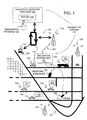
- Figure 1 shows a geographic region 100.
- the geographic region 100 may correspond to a metropolitan or rural area, a state, a country, or combinations thereof, or any other area of comparable size.
- Located in the geographic region 100 is a road network 104.
- a navigation system 110 serves end users (e.g., vehicle drivers and passengers, as well as other persons) in the geographic region 100.
- the navigation system 110 is used by the end users to obtain navigation-related services (including map-related services) with respect to the geographic region 100.
- the navigation-related services include information about travel along the road network 104, including route calculation and guidance, people and business finding services (e.g., electronic yellow and white pages), maps, point of interest searching, destination selection, and so on.
- the navigation system 110 is a combination of hardware, software and data.
- the navigation system 110 includes remote components (i.e., hardware, software or data located at a central location remote from the end users) and local components (i.e., hardware, software, or data located physically with each end user).
- a navigation services server 120 includes a navigation services server 120. Associated with the navigation services server 120 is a geographic database 122. The navigation services server 120 and the geographic database 122 are maintained and operated by a navigation services provider 128.
- the local components of the navigation system 110 include the various computer platforms 130 operated by the end users to request and obtain navigation-related and map-related features and geographic data from the navigation services provider 128.
- These various computer platforms 130 may include navigation system units 132 located in vehicles 134, personal computers 140, personal organizers (e.g., PDAs, PalmPilot®-type devices) 150, portable phones 160, or any other types of computing device that has the appropriate hardware and software to access the navigation services provider 128 over a data network 170.
- the data network 170 may use any suitable technology and/or protocols that are currently available, as well as technology and/or protocols that become available in the future.
- the data network may use WAP, TCP/IP, etc. More than one protocol may be used in the data network 170 with appropriate conversions.
- the data network 170 may be part of, or connected to, the Internet.
- a portion of the network 170 may include a wireless portion 172.
- the wireless portion 172 of the data network 170 enables two-way communication between the mobile end user computing platforms 130 and the service provider 128.
- the wireless portion 172 may be implemented by any suitable form of wireless communication, including cellular, PCS, satellite, FM, radio, or technologies that may be developed in the future.
- the wireless portion 172 may include one or more transmitters 174, such as a transponder tower, an antenna tower, an FM tower, satellites, or other suitable means.
- the transmitters 174 include an appropriate communication link 176 to the network 170 and/or service provider 128. This link 176 may be land-based or may be wireless.
- the transmitters 174 include suitable technology that enables two-way communication between the service provider 128 and the mobile end user computing platforms 130.
- the navigation system 110 of Figure 1 can accommodate different types of end user computing platforms 130.
- the navigation system 110 of Figure 1 allows end users who have different types of computing platforms 130 to obtain navigation services from the navigation services provider 128 and to obtain and use geographic data provided from the navigation services provider 128.
- FIG. 2 is a block diagram showing some of the software components of the navigation services provider 128. Included on the navigation services server 120 of the navigation services provider 128 are server applications 200. One of the server applications 200 is a communications application 212. The communications application 212 interfaces with the data network 170 in order to receive messages from and send messages to the end users. The communications application 212 may also maintain and manage communications sessions with the end users.
- the navigation-related applications 216 use the geographic database 122 associated with the navigation services server 120 in order to provide the various different types of navigation-related services.
- One of the navigation-related applications 216 is a route calculation application 220. Given data that identify the positions of an origin and destination, the route calculation application 220 calculates a route between the origin and the destination.
- the route calculation application 220 may use any of various means or algorithms for this purpose. Methods for calculating routes are disclosed in U.S. Pat. No. 6,192,314, the entire disclosure of which is incorporated by reference herein. (The methods disclosed in the aforementioned patent represent only some of the ways that routes can be calculated and the claimed subject matter herein is not limited to any particular method of route calculation. Any suitable route calculation method now known or developed in the future may be employed.)
- the route calculation application 220 provides an output in the form of a list identifying a continuous series of roads (or segments thereof) that form a legally valid solution route between an origin and a destination.
- a "legally valid solution route" conforms to known traffic restrictions, such as one way streets, turn restrictions, etc.
- the method used by the route calculation application 220 may be designed to optimize the solution route to meet one or more predetermined criteria. Such criteria may include the least travel time, the shortest distance, the fewest turns, etc. If the method used by the route calculation application 220 is designed to find a solution route that is optimized for one or more criteria, then the solution route also ideally meets these one or more criteria.
- the route guidance server application 222 uses the output from the route calculation application 220 to provide instructions for the end user to travel to the desired destination. Methods for providing route guidance using geographic data are disclosed in U.S. Pat. No. 6,199,013, the entire disclosure of which is incorporated herein by reference.
- the route guidance server application 222 provides instructions to end users dynamically. According to this feature, when an end user is provided with instructions for traveling to a destination, the instructions are provided at appropriate times and/or locations as the end user progresses toward the destination. As an example, according to this feature, as the end user approaches an intersection at which a right turn is required, the end user is provided with an instruction "TURN RIGHT AT NEXT INTERSECTION.”
- the end user's computing platform includes positioning equipment, such as a GPS system, inertial sensors, wheel pulse sensors, etc. Using this equipment, the end user's computing platform determines the position of the end user. Data that indicate the end user's position are transmitted to the navigation services provider. Using the data that indicate the end user's position, the route guidance server application 222 on the navigation services server 120 determines the appropriate time and location at which to provide a maneuvering instruction. When the end user approaches the position at which the maneuvering instruction is appropriate, the route guidance server application 222 sends data from which the maneuver can be explicated to the end user. When the data from which the maneuver can be explicated are received on the end user's computing platform, an application (i.e., the route guidance client application 270, described below) on the end user's computing platform uses the data to provide the maneuvering instruction to the end user.
- positioning equipment such as a GPS system, inertial sensors, wheel pulse sensors, etc.
- the route guidance server application 222 on the navigation services server 120 determines several maneuvers required to be made by the end user in order to travel along a route to the desired destination.
- the navigation service server sends data from which these maneuvers can be explicated to the end user.
- the navigation services server also sends data that describe the route.
- the data that describe the route indicate the road segments that form the route.
- the end user's computing platform receives the data indicating the route and the data from which maneuvers along the route can be explicated and stores these data locally.
- the end user's computing platform may have positioning equipment, such as a GPS system, inertial sensors, etc.
- An application on the end user's platform uses the data received from the navigation services server to determine the end user's position along the route. Using this information, the application on the end user's computing platform (i.e., the route guidance client application 270, described below) determines the appropriate time and location to provide each maneuvering instruction to the end user.
- the route guidance server application 222 on the navigation server is capable of providing route guidance dynamically. For example, if changes in traffic conditions affect a route along which an end user is being guided, the route calculation application 220 can calculate a new route. Then, the route guidance server application 222 provides the end user with driving instructions for following the new route that takes into account the changes in traffic conditions.
- the backup driving instructions application 225 may be part of the route guidance server application 222 or may be a standalone application.
- the backup driving instructions application 225 is described in more detail below.
- the navigation services server 120 may include other applications 228.
- the route calculation application 220, the route guidance application 222, the backup driving instructions application 225 and the other applications 228 use data from the geographic database 122.
- the geographic database 122 includes data representing the roads and intersections in the geographic region (100 in Figure 1) and also includes information relating to the represented roads and intersections, such as turn restrictions at intersections, speed limits along the roads, street names of the various roads, address ranges along the roads, and so on.
- the geographic database 122 also contains information about points of interest, businesses and other information.
- the geographic database 122 may be organized to facilitate performing navigation-related functions. Methods of organizing a geographic database to enhance the performance of certain navigation-related functions are described in U.S. Pat. Nos. 5,974,419, 5,968,109 and 5,953,722 the entire disclosures of which are incorporated by reference herein.
- Figure 3 is a block diagram showing some of the components of one of the end user's computing platforms 130.
- Different end user computing platforms may have different hardware and software, and accordingly, the navigation-related functions that are performed on the end users' computing platforms may vary from one end user platform to another.
- the end user's computing platform shown in Figure 3 represents an exemplary embodiment. It is understood that not all end user computing platforms may necessarily provide all the functions of the embodiment in Figure 3 and that some end user computing platforms may provide additional or other functions.
- the exemplary end user's computing platform 130 includes a communications system 250.
- the communications system 250 in the end user's computing platform 130 includes the hardware and software components needed to receive messages from and send messages to the navigation server (120 in Figures 1 and 2) over the data network 170.
- the communications system 250 interfaces with other components in the end user's computing platform 130.
- the end user's computing platform 130 also includes a user interface 256.
- the user interface 256 allows the end user to provide input to and receive information from the end user's computing platform 130.
- the user interface 256 includes hardware and software components.
- the user interface 256 may include a display, a microphone, speakers, a keypad, or other kinds of means for inputting information into the computing platform and outputting information therefrom.
- the user interface 256 includes supporting software that may provide menus, prompts, audio, etc.
- the user interface 256 interfaces with other components in the end user's computing platform 130.
- the navigation-related applications 260 use the geographic data obtained from the navigation server 120 to provide various different types of navigation-related services, including route guidance.
- One of the navigation-related applications 260 is a positioning application 264.
- the positioning application 264 uses the geographic data obtained from the navigation server 120 to determine the position of the end user's computing platform 130 relative to data representing the road network.
- the positioning application 264 may also obtain data from a positioning system 268 that is part of the end user's computing platform 130.
- the positioning system 268 may use GPS, dead-reckoning, or a combination of these or other technologies to determine the location of the end user's computing platform 130. Methods for performing positioning are disclosed in U.S. Pat. No. 6,192,312, the entire disclosure of which is incorporated herein by reference.
- the positioning application 264 is optional, i.e., not all end users' computing platforms may provide for or support positioning.
- the route guidance client application 270 uses data from the navigation server 120 to provide instructions to the end user in order to travel to the destination to which a route has been calculated by the route calculation application 220 on the navigation services server 120.
- the route guidance client application 270 includes two parts. One part of the route guidance client application 270 is the dynamic route guidance client application 272. The other part of the route guidance client application is the backup driving instructions client application 274.
- the dynamic route guidance client application 272 uses the dynamic route guidance data provided by the route guidance server application 222. Using the dynamic route guidance data provided by the route guidance server application 222, the dynamic route guidance client application 272 provides route guidance to the end user as the end user follows the calculated route. As an example, using the dynamic route guidance data from the route guidance server application 222, the dynamic route guidance client application 272 explicates a single upcoming maneuver to the end user as the end user approaches the location at which the maneuver is required to be made.
- the backup driving instructions client application 274 on the end user's computing platform 130 uses the backup driving instruction data provided by the backup driving instructions application 225. Using the backup driving instructions provided by the backup driving instructions application 225, the backup driving instructions client application 274 provides backup route guidance to the end user. As an example, the backup driving instructions may include text descriptions of all the maneuvers that the driver is required to make in order to reach the destination. The backup driving instructions may not be provided dynamically to the end user by the backup driving instructions client application 274. Instead, the backup driving instructions client application 274 may provide the backup driving instructions for the entire route all at once.
- map display application 280 uses data from the navigation services server 120 to provide maps graphically on the display screen of the user interface 256 of the end user's computing platform.
- the maps may show the area around the location of the end user's computing platform, the area along a route that the end user is following, the area around a location specified by the end user, or any other specified area.
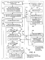
- Figure 4 shows a process 300 performed by the navigation system 110 (in Figure 1) to provide end users with dynamic route guidance and, in addition, to provide end users with backup driving instructions.
- the end user When an end user wants to receive guidance for traveling to a destination, the end user first operates his/her computing platform to establish a communications link to the navigation services server 120 over the wireless network 176 (Steps 304 and 308).
- the end user After establishing a wireless communications link, the end user determines a destination (and possibly an origin) and transmits data indicating the origin and destination to the navigation services server (Step 312).
- the end user specifies an address.
- the end user specifies a type of point of interest (e.g., a restaurant, hotel, gas station, etc.), whereupon the navigation services service finds one or more points of interest of the specified type in proximity to the location of the end user.
- the end user may exchange information with the navigation services server.
- the end user may specify an origin by address.
- the origin is the end user's current location
- data from the positioning application (264 in Figure 3) or positioning system (268 in Figure 3) may be used to indicate the origin.
- the navigation services server 120 After the navigation services server 120 receives the data 316 indicating the origin and destination (Step 320), the navigation services server 120 calculates a solution route from the origin to the destination (Step 324).
- the navigation services server 120 uses the route calculation application (220 in Figure 2) for this purpose.
- the navigation services server 120 sends data to the end user from which the end user can be provided with guidance for following the route (Step 328).
- the navigation services server 120 sends two types of data: dynamic route guidance data 332 and backup driving instruction data 336.
- the dynamic route guidance data 332 are used to provide the end user with maneuvering instructions at appropriate locations along the solution route.
- the dynamic route guidance data 332 may include relatively detailed instructions.
- the dynamic route guidance data 332 may include map data from which a map of the area around the end user's location can be rendered on the display of the end user's computing platform.
- the dynamic route guidance data 332 may also include positioning data relating to the solution route. The positioning data indicate the coordinates of the road segments that form the solution route as well as the coordinates of some road segments located close to the solution route.
- the dynamic route guidance data 332 sent by the navigation services server 120 does not include guidance for the entire route. Instead, the dynamic route guidance data 332 pertain to only the next maneuver or the next several maneuvers that the end user is required to make.
- the other type of data sent by the navigation services server 120 is backup driving instructions data 336.
- the backup driving instructions data 336 include driving instructions for the entire route. However, the backup driving instructions data 336 may include less detail than the dynamic route guidance. For example, the backup driving instructions data 336 may include only text descriptions of the maneuvers that the end user is required to make.
- the end user receives the dynamic route guidance data 332 and the backup data 336 sent by the navigation services server 120 (Step 340).
- the backup guidance client 274 on the end user's computing platform 130 stores the backup driving instructions data 336 in a re-writable data storage device 348 (Step 344).
- the re-writable data storage device 348 may be a flash memory, a hard disk, etc.
- the dynamic route guidance client 272 on the end user's computing platform 130 uses the dynamic route guidance data 332 to provide maneuvering instructions to the end user (Step 352).
- the dynamic route guidance instructions may include audio or visual instructions that indicate the next maneuver required in order to follow the route.
- the instructions may be presented to the end user as the end user approaches the location of the required maneuver.
- the dynamic route guidance client 272 may receive input from the positioning application 264 for this purpose.
- the dynamic route guidance may also use the data 332 for the presentation of a map on the display screen of the user interface 256.
- the dynamic route guidance client 272 may use the map display application 280 for presentation of the map.
- the map shown by the dynamic route guidance client 272 shows the area around the end user.
- the required maneuver may be superimposed on the map.
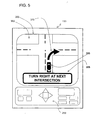
- Figure 5 shows an example of the presentation of dynamic route guidance to the end user.
- Figure 5 shows the display screen 360 of the end user's computing platform 130.
- On the display screen 360 is a map 362 showing the area around the end user's location 366.
- a message 368 is shown on the map 362 indicating the required maneuver.
- the required maneuver is also illustrated graphically, by means of an arrow 370 superimposed on the map 362.
- the route guidance client application 270 determines whether the vehicle is still on the route (Step 378).
- the route guidance client application 270 sends data 380 indicating the vehicle position to the navigation services server 120 (Step 382).
- the navigation services server 120 receives the data 380 indicating the vehicle position (Step 386).
- the navigation services server 120 determines the appropriate upcoming maneuver and transmits data 388 indicating the appropriate upcoming maneuver to the end user's computing platform (Step 396).
- the data 388 sent by the navigation services server are dynamic route guidance data and accordingly are similar to the dynamic route guidance data 332 that have been sent previously.
- the end user's computing platform waits to receive the new dynamic route guidance data 388 (Step 400). If the dynamic route guidance data 388 are received (Step 404), the dynamic route guidance client 272 uses the data 388 to present the end user with new route guidance instructions regarding the next maneuver (Steps 408 and 412). Then, the process 300 continues by looping back to the step (Step 378) in which the route guidance client 270 determines whether the end user is still on the route.
- the end user's computing platform 130 may not receive new dynamic route guidance data from the navigation services server. This may occur for various reasons. For example, the end user may travel outside the coverage area of the wireless network (172 in Figure 1). Alternatively, there may be heavy communications traffic on the network (176 in Figure 1) that causes delays. According to another alternative, there may be equipment malfunctions or maintenance that temporarily interrupts communications between the end user's computing platform and the navigation services server. Regardless of the reason, if the end user's computing platform does not receive new dynamic route guidance data from the navigation services server, the backup driving guidance client 274 retrieves the backup driving instructions data 336 from the data storage 348 (Steps 404 and 416). Then, the backup guidance client 274 uses the backup driving instructions 336 to provide route guidance to the end user (Step 412).
- the backup guidance client 274 When the backup guidance client 274 provides route guidance to the end user, the guidance is not as detailed as the route guidance provided by the dynamic route guidance client 272. For example, the backup guidance client 274 may provide only text descriptions of the required maneuvers to the end user. In addition, when the backup guidance client 274 provides route guidance to the end user, the backup driving instructions may not be presented one at a time as the locations at which the maneuvers required to be made are being approached. Instead, when the backup guidance client 274 provides route guidance to the end user, the backup driving instructions may be provided to the end user all at once.
- Figure 6 shows an example of the presentation of backup driving instructions to the end user.
- Figure 6 shows the display screen 360 of the end user's computing platform 130.
- On the display screen 360 is a listing 430 of each of the maneuvers required to follow the route.
- a message 434 is displayed indicating that backup driving instructions are being presented.
- the display screen 360 may include as many instructions that can reasonably fit on the screen. The rest of the instructions may be viewed by scrolling through the list 430, e.g., using controls on the user interface 256.
- the process 300 loops back to the steps in which a determination is made whether the vehicle is still on the route (Step 378), the vehicle position is sent to the navigation services server (Step 382), and new dynamic route guidance data from the navigation services server is expected (Step 400). If communications with the navigation services server are reestablished, new dynamic route guidance data are obtained from the navigation services server and dynamic route guidance is provided to the end user (Steps 400, 404, 408, and 412). Otherwise, if communications with the navigation services server are not reestablished, the backup guidance client 274 continues to present the backup driving instructions to the end user (Step 412).
- some end user computing platforms included a positioning system and/or a positioning application by which the location of the end user's computing platform could be determined.
- the location of an end user can be determined by a positioning system located outside the end user's computing platform.
- Systems for determining the position of a user of a wireless communications device are known. For example, there are systems that can determine the positions of users of cellular phones. These systems may determine the location of a cellular phone user who requests emergency service, e.g., "emergency 911 service.” These systems use various technologies, such as triangulation, time-of-arrival, etc., in order to determine a position of a cellular phone user.
- ArrayComm, Inc. Harris Corporation, Corsair Communications, Lockheed Martin Corporation, CELLTRAX, Inc., TruePosition, Inc., Cell-Loc Inc., KSI Inc., and U.S. Wireless Corporation. Any such technology that is presently available or that becomes available in the future may be suitable for the positioning system.
Priority Applications (2)
| Application Number | Priority Date | Filing Date | Title |
|---|---|---|---|
| EP13177112.3A EP2738521B1 (de) | 2001-05-10 | 2002-04-22 | Verfahren und System zum Bereitstellen dynamischer Fahranweisungen durch ein Navigationssystem |
| EP13160479.5A EP2626669B1 (de) | 2001-05-10 | 2002-04-22 | Verfahren, Vorrichtungen und Computerprogramme zur Bereitstellung zwischengespeicherter Fahranweisungen durch ein verteiltes Navigationssystem |
Applications Claiming Priority (2)
| Application Number | Priority Date | Filing Date | Title |
|---|---|---|---|
| US852879 | 2001-05-10 | ||
| US09/852,879 US6725156B2 (en) | 2001-05-10 | 2001-05-10 | Method and system for providing backup driving instructions with a navigation system |
Related Child Applications (4)
| Application Number | Title | Priority Date | Filing Date |
|---|---|---|---|
| EP13160479.5A Division EP2626669B1 (de) | 2001-05-10 | 2002-04-22 | Verfahren, Vorrichtungen und Computerprogramme zur Bereitstellung zwischengespeicherter Fahranweisungen durch ein verteiltes Navigationssystem |
| EP13160479.5A Division-Into EP2626669B1 (de) | 2001-05-10 | 2002-04-22 | Verfahren, Vorrichtungen und Computerprogramme zur Bereitstellung zwischengespeicherter Fahranweisungen durch ein verteiltes Navigationssystem |
| EP13177112.3A Division EP2738521B1 (de) | 2001-05-10 | 2002-04-22 | Verfahren und System zum Bereitstellen dynamischer Fahranweisungen durch ein Navigationssystem |
| EP13177112.3A Division-Into EP2738521B1 (de) | 2001-05-10 | 2002-04-22 | Verfahren und System zum Bereitstellen dynamischer Fahranweisungen durch ein Navigationssystem |
Publications (3)
| Publication Number | Publication Date |
|---|---|
| EP1256785A2 true EP1256785A2 (de) | 2002-11-13 |
| EP1256785A3 EP1256785A3 (de) | 2011-04-20 |
| EP1256785B1 EP1256785B1 (de) | 2014-09-10 |
Family
ID=25314474
Family Applications (3)
| Application Number | Title | Priority Date | Filing Date |
|---|---|---|---|
| EP13160479.5A Expired - Lifetime EP2626669B1 (de) | 2001-05-10 | 2002-04-22 | Verfahren, Vorrichtungen und Computerprogramme zur Bereitstellung zwischengespeicherter Fahranweisungen durch ein verteiltes Navigationssystem |
| EP02252803.8A Expired - Lifetime EP1256785B1 (de) | 2001-05-10 | 2002-04-22 | Verfahren, Vorrichtungen und Computerprogramme zur Versorgung eines Navigationssystems mit Reserve-Fahrinstruktionen |
| EP13177112.3A Expired - Lifetime EP2738521B1 (de) | 2001-05-10 | 2002-04-22 | Verfahren und System zum Bereitstellen dynamischer Fahranweisungen durch ein Navigationssystem |
Family Applications Before (1)
| Application Number | Title | Priority Date | Filing Date |
|---|---|---|---|
| EP13160479.5A Expired - Lifetime EP2626669B1 (de) | 2001-05-10 | 2002-04-22 | Verfahren, Vorrichtungen und Computerprogramme zur Bereitstellung zwischengespeicherter Fahranweisungen durch ein verteiltes Navigationssystem |
Family Applications After (1)
| Application Number | Title | Priority Date | Filing Date |
|---|---|---|---|
| EP13177112.3A Expired - Lifetime EP2738521B1 (de) | 2001-05-10 | 2002-04-22 | Verfahren und System zum Bereitstellen dynamischer Fahranweisungen durch ein Navigationssystem |
Country Status (3)
| Country | Link |
|---|---|
| US (1) | US6725156B2 (de) |
| EP (3) | EP2626669B1 (de) |
| JP (1) | JP4180837B2 (de) |
Cited By (5)
| Publication number | Priority date | Publication date | Assignee | Title |
|---|---|---|---|---|
| EP1482279A2 (de) | 2003-05-24 | 2004-12-01 | Jentro Technologies GmbH | Navigationssystem |
| EP1677078A2 (de) | 2004-12-28 | 2006-07-05 | Nissan Motor Company, Limited | Navigationssystem und -verfahren |
| EP2075544A1 (de) | 2007-12-27 | 2009-07-01 | LG Electronics Inc. | Fernsteuerungsvorrichtung |
| CN101739836B (zh) * | 2009-12-18 | 2012-05-23 | 吉林大学 | 大规模路网下中心式实时动态交通诱导路径优化方法 |
| EP2887019A1 (de) * | 2013-12-17 | 2015-06-24 | Alpine Electronics, Inc. | Navigationsvorrichtung und Navigationssystem |
Families Citing this family (18)
| Publication number | Priority date | Publication date | Assignee | Title |
|---|---|---|---|---|
| US20030231755A1 (en) * | 2002-06-18 | 2003-12-18 | Akhteruzzaman | Directory assistance |
| US8977284B2 (en) | 2001-10-04 | 2015-03-10 | Traxcell Technologies, LLC | Machine for providing a dynamic data base of geographic location information for a plurality of wireless devices and process for making same |
| US6915310B2 (en) * | 2002-03-28 | 2005-07-05 | Harris Corporation | Three-dimensional volumetric geo-spatial querying |
| GB2389679B (en) * | 2002-06-14 | 2005-09-07 | Yeoman Group Plc | Mobile navigation |
| US8560223B2 (en) | 2002-08-29 | 2013-10-15 | Mapquest, Inc. | Automated route determination |
| US20040044465A1 (en) * | 2002-08-29 | 2004-03-04 | Nesbitt David W. | Automated route determination based on day of route traversal |
| US7133771B1 (en) * | 2002-08-29 | 2006-11-07 | America Online, Inc. | Automated route determination to avoid a particular maneuver |
| JP4279532B2 (ja) * | 2002-10-01 | 2009-06-17 | 株式会社アマダ | 成形製品の加工方法に使用する金型装置及び下金型 |
| KR100451439B1 (ko) * | 2002-10-23 | 2004-10-06 | 에스케이 텔레콤주식회사 | 차량용 네비게이션 시스템 및 그 제어 방법 |
| US7474960B1 (en) * | 2002-12-30 | 2009-01-06 | Mapquest, Inc. | Presenting a travel route |
| US7321824B1 (en) * | 2002-12-30 | 2008-01-22 | Aol Llc | Presenting a travel route using more than one presentation style |
| US7818116B1 (en) | 2002-12-30 | 2010-10-19 | Mapquest, Inc. | Presenting a travel route in a ground-based vehicle |
| US7966003B2 (en) * | 2004-07-09 | 2011-06-21 | Tegic Communications, Inc. | Disambiguating ambiguous characters |
| US7292189B2 (en) * | 2004-09-10 | 2007-11-06 | Worcester Polytechnic Institute | Methods and apparatus for high resolution positioning |
| US9683850B2 (en) * | 2009-02-03 | 2017-06-20 | Telenav, Inc. | Method for navigation using adaptive coverage |
| US8301996B2 (en) * | 2009-03-19 | 2012-10-30 | Microsoft Corporation | Annotating images with instructions |
| US9541402B2 (en) * | 2010-03-31 | 2017-01-10 | Telenav, Inc. | Hybrid navigation system with location based services and method of operation thereof |
| US9182498B2 (en) * | 2010-03-31 | 2015-11-10 | Telenav Inc. | Hybrid navigation system with non-network update and method of operation thereof |
Citations (3)
| Publication number | Priority date | Publication date | Assignee | Title |
|---|---|---|---|---|
| DE4214067A1 (de) | 1992-04-29 | 1993-11-04 | Heinrich Wanko | Verfahren zur ueberwachung des transports von guetern zu vorbestimmten abnahmestellen |
| US5610821A (en) | 1994-11-18 | 1997-03-11 | Ibm Corporation | Optimal and stable route planning system |
| DE19539641A1 (de) | 1995-10-25 | 1997-04-30 | Daimler Benz Ag | Verfahren und Einrichtung zur verkehrssituationsabhängigen Fahrzeugzielführung |
Family Cites Families (27)
| Publication number | Priority date | Publication date | Assignee | Title |
|---|---|---|---|---|
| US3749333A (en) * | 1972-06-15 | 1973-07-31 | Lear Siegler Inc | Dead reckoning back-up navigational system for a drone |
| JPS58190713A (ja) | 1982-05-01 | 1983-11-07 | Honda Motor Co Ltd | 移動体の現在位置表示装置 |
| US5087919A (en) | 1989-09-05 | 1992-02-11 | Pioneer Electronic Corporation | On-board navigation apparatus |
| US5243528A (en) * | 1990-09-12 | 1993-09-07 | Motorola, Inc. | Land vehicle navigation apparatus with visual display |
| JPH04315913A (ja) | 1991-04-16 | 1992-11-06 | Pioneer Electron Corp | 車両方位測定装置 |
| GB9417600D0 (en) * | 1994-09-01 | 1994-10-19 | British Telecomm | Navigation information system |
| JP3632706B2 (ja) * | 1994-09-22 | 2005-03-23 | アイシン・エィ・ダブリュ株式会社 | 車両用ナビゲーション装置 |
| US5835061A (en) * | 1995-06-06 | 1998-11-10 | Wayport, Inc. | Method and apparatus for geographic-based communications service |
| US6259405B1 (en) * | 1995-06-06 | 2001-07-10 | Wayport, Inc. | Geographic based communications service |
| US5724316A (en) * | 1995-09-26 | 1998-03-03 | Delco Electronics Corporation | GPS based time determining system and method |
| JPH1069219A (ja) | 1996-08-28 | 1998-03-10 | Honda Motor Co Ltd | 自動走行路および自動走行システム |
| US5953722A (en) | 1996-10-25 | 1999-09-14 | Navigation Technologies Corporation | Method and system for forming and using geographic data |
| US5968109A (en) | 1996-10-25 | 1999-10-19 | Navigation Technologies Corporation | System and method for use and storage of geographic data on physical media |
| US5974419A (en) | 1996-10-25 | 1999-10-26 | Navigation Technologies Corporation | Parcelization of geographic data for storage and use in a navigation application |
| DE19808111B4 (de) | 1997-02-28 | 2007-04-05 | Aisin AW Co., Ltd., Anjo | Fahrzeugnavigationssystem |
| FR2762906B1 (fr) * | 1997-05-02 | 1999-06-04 | Renault | Procede et dispositif de guidage de vehicule automobile |
| US6199013B1 (en) | 1997-07-15 | 2001-03-06 | Navigation Technologies Corp. | Maneuver generation program and method |
| JP2002506197A (ja) * | 1997-08-19 | 2002-02-26 | シーメンス オートモーティヴ コーポレイション | 車両情報システム |
| US6092076A (en) | 1998-03-24 | 2000-07-18 | Navigation Technologies Corporation | Method and system for map display in a navigation application |
| US6192314B1 (en) | 1998-03-25 | 2001-02-20 | Navigation Technologies Corp. | Method and system for route calculation in a navigation application |
| US6163749A (en) | 1998-06-05 | 2000-12-19 | Navigation Technologies Corp. | Method and system for scrolling a map display in a navigation application |
| US6314369B1 (en) * | 1998-07-02 | 2001-11-06 | Kabushikikaisha Equos Research | Communications navigation system, and navigation base apparatus and navigation apparatus both used in the navigation system |
| AUPP523398A0 (en) * | 1998-08-12 | 1998-09-03 | Alter-Tech Pty. Ltd. | Turn-by-turn route system |
| US6400690B1 (en) | 1998-10-15 | 2002-06-04 | International Business Machines Corporation | Dual map system for navigation and wireless communication |
| US6192312B1 (en) | 1999-03-25 | 2001-02-20 | Navigation Technologies Corp. | Position determining program and method |
| JP3596805B2 (ja) * | 1999-07-29 | 2004-12-02 | 松下電器産業株式会社 | 情報端末装置および経路案内方法 |
| JP4147712B2 (ja) | 1999-11-18 | 2008-09-10 | 株式会社エクォス・リサーチ | 通信型経路案内システム |
-
2001
- 2001-05-10 US US09/852,879 patent/US6725156B2/en not_active Expired - Lifetime
-
2002
- 2002-04-22 EP EP13160479.5A patent/EP2626669B1/de not_active Expired - Lifetime
- 2002-04-22 EP EP02252803.8A patent/EP1256785B1/de not_active Expired - Lifetime
- 2002-04-22 EP EP13177112.3A patent/EP2738521B1/de not_active Expired - Lifetime
- 2002-05-09 JP JP2002134167A patent/JP4180837B2/ja not_active Expired - Lifetime
Patent Citations (3)
| Publication number | Priority date | Publication date | Assignee | Title |
|---|---|---|---|---|
| DE4214067A1 (de) | 1992-04-29 | 1993-11-04 | Heinrich Wanko | Verfahren zur ueberwachung des transports von guetern zu vorbestimmten abnahmestellen |
| US5610821A (en) | 1994-11-18 | 1997-03-11 | Ibm Corporation | Optimal and stable route planning system |
| DE19539641A1 (de) | 1995-10-25 | 1997-04-30 | Daimler Benz Ag | Verfahren und Einrichtung zur verkehrssituationsabhängigen Fahrzeugzielführung |
Cited By (9)
| Publication number | Priority date | Publication date | Assignee | Title |
|---|---|---|---|---|
| EP1482279A2 (de) | 2003-05-24 | 2004-12-01 | Jentro Technologies GmbH | Navigationssystem |
| EP1482279A3 (de) * | 2003-05-24 | 2008-04-02 | Jentro Technologies GmbH | Navigationssystem |
| EP1677078A2 (de) | 2004-12-28 | 2006-07-05 | Nissan Motor Company, Limited | Navigationssystem und -verfahren |
| EP1677078A3 (de) * | 2004-12-28 | 2009-08-19 | Nissan Motor Company, Limited | Navigationssystem und -verfahren |
| US7729854B2 (en) | 2004-12-28 | 2010-06-01 | Nissan Motor Co., Ltd. | System and method for navigation |
| EP2075544A1 (de) | 2007-12-27 | 2009-07-01 | LG Electronics Inc. | Fernsteuerungsvorrichtung |
| US8073621B2 (en) | 2007-12-27 | 2011-12-06 | Lg Electronics Inc. | Navigation apparatus and method for providing turn-by-turn position list |
| CN101739836B (zh) * | 2009-12-18 | 2012-05-23 | 吉林大学 | 大规模路网下中心式实时动态交通诱导路径优化方法 |
| EP2887019A1 (de) * | 2013-12-17 | 2015-06-24 | Alpine Electronics, Inc. | Navigationsvorrichtung und Navigationssystem |
Also Published As
| Publication number | Publication date |
|---|---|
| US20020169549A1 (en) | 2002-11-14 |
| EP2626669A1 (de) | 2013-08-14 |
| EP2738521A3 (de) | 2014-07-09 |
| EP2738521B1 (de) | 2017-02-08 |
| EP2738521A2 (de) | 2014-06-04 |
| EP2626669B1 (de) | 2016-10-19 |
| EP1256785B1 (de) | 2014-09-10 |
| US6725156B2 (en) | 2004-04-20 |
| JP4180837B2 (ja) | 2008-11-12 |
| JP2003035549A (ja) | 2003-02-07 |
| EP1256785A3 (de) | 2011-04-20 |
Similar Documents
| Publication | Publication Date | Title |
|---|---|---|
| US6725156B2 (en) | Method and system for providing backup driving instructions with a navigation system | |
| US8010227B2 (en) | Navigation system with downloadable map data | |
| US6424910B1 (en) | Method and system for providing related navigation features for two or more end users | |
| US6314365B1 (en) | Method and system of providing navigation services to cellular phone devices from a server | |
| US7627426B2 (en) | Geographic database including data indicating wireless coverage and method and system for use thereof | |
| AU2005292243B2 (en) | Off board navigation solution | |
| US6691128B2 (en) | Navigation system with distributed computing architecture | |
| US20060247848A1 (en) | Driving route planning system and method | |
| EP3441723B1 (de) | Navigationssystem und verfahren zum austausch von wechselseitigen ortsinformationen unter verwendung eines kuriers | |
| TW201128168A (en) | Navigation device & and method | |
| CN102187177A (zh) | 用于提供启程时间的导航系统及方法 | |
| JPH1151666A (ja) | 移動通信端末向け情報検索配信装置および移動通信端末 | |
| US20080275638A1 (en) | Conducting localized searches in a wireless client-server navigation system | |
| EP1387145A1 (de) | Differentielles dynamisches Navigationssystem für Off-board-Fahrzeugnavigation | |
| JP2013050792A (ja) | 情報配信装置、情報配信システム、情報配信方法および情報配信プログラム | |
| KR20020070932A (ko) | 실시간 교통정보망과 연계된 네비게이션 시스템의음성인식 장치 및 그 이용방법 | |
| KR100430036B1 (ko) | 차량 항법 및 지리 정보 제공 장치 및 그 방법 | |
| TW201028666A (en) | Navigation device & method | |
| CA2556640A1 (en) | Off-board navigational system |
Legal Events
| Date | Code | Title | Description |
|---|---|---|---|
| PUAI | Public reference made under article 153(3) epc to a published international application that has entered the european phase |
Free format text: ORIGINAL CODE: 0009012 |
|
| AK | Designated contracting states |
Kind code of ref document: A2 Designated state(s): AT BE CH CY DE DK ES FI FR GB GR IE IT LI LU MC NL PT SE TR |
|
| AX | Request for extension of the european patent |
Free format text: AL;LT;LV;MK;RO;SI |
|
| RAP1 | Party data changed (applicant data changed or rights of an application transferred) |
Owner name: NAVTEQ NORTH AMERICA, LLC |
|
| RAP1 | Party data changed (applicant data changed or rights of an application transferred) |
Owner name: NAVTEQ NORTH AMERICA, LLC |
|
| PUAL | Search report despatched |
Free format text: ORIGINAL CODE: 0009013 |
|
| AK | Designated contracting states |
Kind code of ref document: A3 Designated state(s): AT BE CH CY DE DK ES FI FR GB GR IE IT LI LU MC NL PT SE TR |
|
| AX | Request for extension of the european patent |
Extension state: AL LT LV MK RO SI |
|
| 17P | Request for examination filed |
Effective date: 20110614 |
|
| 17Q | First examination report despatched |
Effective date: 20110720 |
|
| AKX | Designation fees paid |
Designated state(s): AT BE CH CY DE DK ES FI FR GB GR IE IT LI LU MC NL PT SE TR |
|
| REG | Reference to a national code |
Ref country code: DE Ref legal event code: R079 Ref document number: 60246616 Country of ref document: DE Free format text: PREVIOUS MAIN CLASS: G01C0021340000 Ipc: G01C0021360000 |
|
| GRAP | Despatch of communication of intention to grant a patent |
Free format text: ORIGINAL CODE: EPIDOSNIGR1 |
|
| RIC1 | Information provided on ipc code assigned before grant |
Ipc: G01C 21/36 20060101AFI20121122BHEP |
|
| RAP1 | Party data changed (applicant data changed or rights of an application transferred) |
Owner name: NAVTEQ B.V. |
|
| RAP1 | Party data changed (applicant data changed or rights of an application transferred) |
Owner name: HERE GLOBAL B.V. |
|
| GRAP | Despatch of communication of intention to grant a patent |
Free format text: ORIGINAL CODE: EPIDOSNIGR1 |
|
| INTG | Intention to grant announced |
Effective date: 20140213 |
|
| GRAP | Despatch of communication of intention to grant a patent |
Free format text: ORIGINAL CODE: EPIDOSNIGR1 |
|
| GRAS | Grant fee paid |
Free format text: ORIGINAL CODE: EPIDOSNIGR3 |
|
| INTG | Intention to grant announced |
Effective date: 20140708 |
|
| GRAA | (expected) grant |
Free format text: ORIGINAL CODE: 0009210 |
|
| AK | Designated contracting states |
Kind code of ref document: B1 Designated state(s): AT BE CH CY DE DK ES FI FR GB GR IE IT LI LU MC NL PT SE TR |
|
| REG | Reference to a national code |
Ref country code: GB Ref legal event code: FG4D |
|
| REG | Reference to a national code |
Ref country code: CH Ref legal event code: EP |
|
| REG | Reference to a national code |
Ref country code: IE Ref legal event code: FG4D |
|
| REG | Reference to a national code |
Ref country code: AT Ref legal event code: REF Ref document number: 686924 Country of ref document: AT Kind code of ref document: T Effective date: 20141015 |
|
| REG | Reference to a national code |
Ref country code: DE Ref legal event code: R096 Ref document number: 60246616 Country of ref document: DE Effective date: 20141016 |
|
| PG25 | Lapsed in a contracting state [announced via postgrant information from national office to epo] |
Ref country code: FI Free format text: LAPSE BECAUSE OF FAILURE TO SUBMIT A TRANSLATION OF THE DESCRIPTION OR TO PAY THE FEE WITHIN THE PRESCRIBED TIME-LIMIT Effective date: 20140910 Ref country code: GR Free format text: LAPSE BECAUSE OF FAILURE TO SUBMIT A TRANSLATION OF THE DESCRIPTION OR TO PAY THE FEE WITHIN THE PRESCRIBED TIME-LIMIT Effective date: 20141211 Ref country code: ES Free format text: LAPSE BECAUSE OF FAILURE TO SUBMIT A TRANSLATION OF THE DESCRIPTION OR TO PAY THE FEE WITHIN THE PRESCRIBED TIME-LIMIT Effective date: 20140910 Ref country code: SE Free format text: LAPSE BECAUSE OF FAILURE TO SUBMIT A TRANSLATION OF THE DESCRIPTION OR TO PAY THE FEE WITHIN THE PRESCRIBED TIME-LIMIT Effective date: 20140910 |
|
| REG | Reference to a national code |
Ref country code: NL Ref legal event code: VDEP Effective date: 20140910 |
|
| PG25 | Lapsed in a contracting state [announced via postgrant information from national office to epo] |
Ref country code: CY Free format text: LAPSE BECAUSE OF FAILURE TO SUBMIT A TRANSLATION OF THE DESCRIPTION OR TO PAY THE FEE WITHIN THE PRESCRIBED TIME-LIMIT Effective date: 20140910 |
|
| REG | Reference to a national code |
Ref country code: AT Ref legal event code: MK05 Ref document number: 686924 Country of ref document: AT Kind code of ref document: T Effective date: 20140910 |
|
| PG25 | Lapsed in a contracting state [announced via postgrant information from national office to epo] |
Ref country code: NL Free format text: LAPSE BECAUSE OF FAILURE TO SUBMIT A TRANSLATION OF THE DESCRIPTION OR TO PAY THE FEE WITHIN THE PRESCRIBED TIME-LIMIT Effective date: 20140910 |
|
| PG25 | Lapsed in a contracting state [announced via postgrant information from national office to epo] |
Ref country code: PT Free format text: LAPSE BECAUSE OF FAILURE TO SUBMIT A TRANSLATION OF THE DESCRIPTION OR TO PAY THE FEE WITHIN THE PRESCRIBED TIME-LIMIT Effective date: 20150112 |
|
| PG25 | Lapsed in a contracting state [announced via postgrant information from national office to epo] |
Ref country code: AT Free format text: LAPSE BECAUSE OF FAILURE TO SUBMIT A TRANSLATION OF THE DESCRIPTION OR TO PAY THE FEE WITHIN THE PRESCRIBED TIME-LIMIT Effective date: 20140910 |
|
| REG | Reference to a national code |
Ref country code: DE Ref legal event code: R097 Ref document number: 60246616 Country of ref document: DE |
|
| PLBE | No opposition filed within time limit |
Free format text: ORIGINAL CODE: 0009261 |
|
| STAA | Information on the status of an ep patent application or granted ep patent |
Free format text: STATUS: NO OPPOSITION FILED WITHIN TIME LIMIT |
|
| PG25 | Lapsed in a contracting state [announced via postgrant information from national office to epo] |
Ref country code: DK Free format text: LAPSE BECAUSE OF FAILURE TO SUBMIT A TRANSLATION OF THE DESCRIPTION OR TO PAY THE FEE WITHIN THE PRESCRIBED TIME-LIMIT Effective date: 20140910 |
|
| 26N | No opposition filed |
Effective date: 20150611 |
|
| PG25 | Lapsed in a contracting state [announced via postgrant information from national office to epo] |
Ref country code: IT Free format text: LAPSE BECAUSE OF FAILURE TO SUBMIT A TRANSLATION OF THE DESCRIPTION OR TO PAY THE FEE WITHIN THE PRESCRIBED TIME-LIMIT Effective date: 20140910 |
|
| PG25 | Lapsed in a contracting state [announced via postgrant information from national office to epo] |
Ref country code: LU Free format text: LAPSE BECAUSE OF FAILURE TO SUBMIT A TRANSLATION OF THE DESCRIPTION OR TO PAY THE FEE WITHIN THE PRESCRIBED TIME-LIMIT Effective date: 20150422 Ref country code: MC Free format text: LAPSE BECAUSE OF FAILURE TO SUBMIT A TRANSLATION OF THE DESCRIPTION OR TO PAY THE FEE WITHIN THE PRESCRIBED TIME-LIMIT Effective date: 20140910 |
|
| REG | Reference to a national code |
Ref country code: CH Ref legal event code: PL |
|
| GBPC | Gb: european patent ceased through non-payment of renewal fee |
Effective date: 20150422 |
|
| REG | Reference to a national code |
Ref country code: IE Ref legal event code: MM4A |
|
| PG25 | Lapsed in a contracting state [announced via postgrant information from national office to epo] |
Ref country code: CH Free format text: LAPSE BECAUSE OF NON-PAYMENT OF DUE FEES Effective date: 20150430 Ref country code: LI Free format text: LAPSE BECAUSE OF NON-PAYMENT OF DUE FEES Effective date: 20150430 Ref country code: GB Free format text: LAPSE BECAUSE OF NON-PAYMENT OF DUE FEES Effective date: 20150422 |
|
| REG | Reference to a national code |
Ref country code: FR Ref legal event code: ST Effective date: 20151231 |
|
| PG25 | Lapsed in a contracting state [announced via postgrant information from national office to epo] |
Ref country code: FR Free format text: LAPSE BECAUSE OF NON-PAYMENT OF DUE FEES Effective date: 20150430 |
|
| PG25 | Lapsed in a contracting state [announced via postgrant information from national office to epo] |
Ref country code: IE Free format text: LAPSE BECAUSE OF NON-PAYMENT OF DUE FEES Effective date: 20150422 |
|
| PG25 | Lapsed in a contracting state [announced via postgrant information from national office to epo] |
Ref country code: BE Free format text: LAPSE BECAUSE OF FAILURE TO SUBMIT A TRANSLATION OF THE DESCRIPTION OR TO PAY THE FEE WITHIN THE PRESCRIBED TIME-LIMIT Effective date: 20140910 |
|
| PG25 | Lapsed in a contracting state [announced via postgrant information from national office to epo] |
Ref country code: TR Free format text: LAPSE BECAUSE OF FAILURE TO SUBMIT A TRANSLATION OF THE DESCRIPTION OR TO PAY THE FEE WITHIN THE PRESCRIBED TIME-LIMIT Effective date: 20140910 |
|
| PGFP | Annual fee paid to national office [announced via postgrant information from national office to epo] |
Ref country code: DE Payment date: 20210323 Year of fee payment: 20 |
|
| REG | Reference to a national code |
Ref country code: DE Ref legal event code: R071 Ref document number: 60246616 Country of ref document: DE |