EP1129422B1 - Computer-unterstütztes verfahren und system zum entwerfen von transportrouten - Google Patents
Computer-unterstütztes verfahren und system zum entwerfen von transportrouten Download PDFInfo
- Publication number
- EP1129422B1 EP1129422B1 EP99947834A EP99947834A EP1129422B1 EP 1129422 B1 EP1129422 B1 EP 1129422B1 EP 99947834 A EP99947834 A EP 99947834A EP 99947834 A EP99947834 A EP 99947834A EP 1129422 B1 EP1129422 B1 EP 1129422B1
- Authority
- EP
- European Patent Office
- Prior art keywords
- replaced
- cost
- transportation route
- linear objective
- objective function
- Prior art date
- Legal status (The legal status is an assumption and is not a legal conclusion. Google has not performed a legal analysis and makes no representation as to the accuracy of the status listed.)
- Expired - Lifetime
Links
Images



Classifications
-
- G—PHYSICS
- G06—COMPUTING OR CALCULATING; COUNTING
- G06Q—INFORMATION AND COMMUNICATION TECHNOLOGY [ICT] SPECIALLY ADAPTED FOR ADMINISTRATIVE, COMMERCIAL, FINANCIAL, MANAGERIAL OR SUPERVISORY PURPOSES; SYSTEMS OR METHODS SPECIALLY ADAPTED FOR ADMINISTRATIVE, COMMERCIAL, FINANCIAL, MANAGERIAL OR SUPERVISORY PURPOSES, NOT OTHERWISE PROVIDED FOR
- G06Q10/00—Administration; Management
- G06Q10/06—Resources, workflows, human or project management; Enterprise or organisation planning; Enterprise or organisation modelling
-
- G—PHYSICS
- G06—COMPUTING OR CALCULATING; COUNTING
- G06F—ELECTRIC DIGITAL DATA PROCESSING
- G06F30/00—Computer-aided design [CAD]
- G06F30/10—Geometric CAD
- G06F30/13—Architectural design, e.g. computer-aided architectural design [CAAD] related to design of buildings, bridges, landscapes, production plants or roads
-
- G—PHYSICS
- G06—COMPUTING OR CALCULATING; COUNTING
- G06F—ELECTRIC DIGITAL DATA PROCESSING
- G06F2111/00—Details relating to CAD techniques
- G06F2111/04—Constraint-based CAD
Definitions
- This invention relates to techniques for designing transport routes.
- Such equalization is an iterative process requiring repeated fine-tuning by the engineer.
- the iteration may be repeated numerous times before the road system satisfies all of the physical constraints and the cut and fill quantities are properly balanced.
- the design has been a trial and error affair according to the experience of the civil engineer.
- the vertical alignment is determined for one road at a time and not for the entire road system. Earthworks of subdivision lots which border transportation routes have also not conventionally been taken into account, nor has the economical factor been properly considered.
- a principal the object of the invention is thus to develop a method of road design that results in lower construction cost.
- a further object of the invention is to facilitate comparison of different layouts and different unit prices so as to obtain better cost-effectiveness during the preliminary planning stage.
- a computer-implemented method and system as defined in claims 1 and 8, respectively Such a method establishes a direct relationship between prevailing economic conditions and the status of the transportation system as a technico/ entity.
- the method according to the invention utilizes customized optimization which operate on raw data generated by a computer-aided design (CAD) program.
- CAD computer-aided design
- Such raw data includes: topography, roads centerlines plan, road cross-sections and earthwork unit prices.
- a "transport system” is any highway system comprising one or more roads, pedestrian routes or rail tracks or a combination thereof
- the invention is of particular benefit for the optimization of complete transport systems having many intersecting roads or rail tracks, whilst nevertheless being applicable to the design of single transport routes only.
- Fig. 1 is a flow diagram showing the principal steps associated with an optimization process according to the invention using linear or nonlinear programming. Three approaches are described differing in the number of variables and the performance time.
- the optimization is reached through nonlinear programming when the objective is to minimize the total cost of the earthworks.
- the required variables are differences between proposed road elevations and existing topography elevations at all grid points on the right of way.
- the relevant constraints are prevailing roads standards.
- Fig. 2 shows in plan view a road surface 10 having superimposed thereon an imaginary matrix of grid points designated GP each being a node point of a rectangular grid of definite size (e.g. 5m x 5m) that are located on the right of way.
- Boundary grid points designated BGP are grid points located on edges of roads, i.e. points for which distance to the road centerline is equal to half of the road width (with some tolerance). Boundary grid points are used for cost estimation of retaining walls which support the earth under the road surface when the surface of the road is higher than that of the surrounding landscape, thus requiring earth to be filled to the level of the road surface.
- retaining walls are built when the level of the surrounding landscape is higher than that of the road surface, thus requiring the earth to be cut down to the level of the road surface.
- the retaining walls serve the function of preventing rubble from falling on to the road surface.
- Both grid points and boundary grid points are quantified by coordinates in 3-dimensional space.
- control points designated CP being 3D points on the proposed centerlines of the road system (e.g. every 100m). As shown in Fig. 2 , control points are not necessarily coincident with grid points. Tne gradient or "grade" of a road can be changed only at control points, such that each road section spanning a pair of control points is linear.
- control points are located at points of centerlines where grades of the existing profile are changed, in order to improve the optimization process.
- each grid point may be determined by linear interpolation from the proposed elevations of a corresponding pair of control points.
- K q is number of different geological layers each having a specified excavation price at the point Q
- Pqmax excavation price for Z q ⁇ bK q . (Here Z q , aj q , bj q , bK q ⁇ 0).
- V q (Z q ) 0.
- Constraints include five sets:
- Equation (1) The expressions which appear in the objective function shown in Equation (1) include absolute values of the respective differences between variables and parameters, thus rendering the objective function non-linear. However, these absolute values can be transformed into linear form:
- Equation (1) instead of
- the constraints no longer include Z q , but only their expressions via Uq... 1 ,Uq... 2 .
- the cost can be further reduced by increasing the number of control points and/or by allowing the road surface to have a higher gradient.
- the accuracy of the result can be improved by reducing the spacing between adjacent grid points and employing a finer resolution Digital Terrain Model, but this dramatically increases the number of variables.
- the method described above allows cost optimization of the complete surface of a transport route typically comprising many roads or railway track surfaces. There may, however, be times when optimization of the complete surface is impractical or undesirable, for example when time or memory considerations do not allow such optimization. In this case, a lower precision approximation may be achieved by optimizing only the routes' centerlines using linear programming when the objective is to minimize the cumulative difference between the proposed roads' elevations and the existing elevations dictated by the initial topography at the control points, i.e. the difference between cut and fill volumes for centerlines only at each control point.
- This approach takes into account only the control points i.e. points on the centerlines of the road system.
- the gradient of a road can be changed only at the control points which are defined by the end-user, either manually or automatically.
- the control points are located at the points of centerlines where the gradient of the existing profile changes, thereby improving the optimization process.
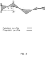
- Fig. 3 shows existing and proposed vertical profiles of road centerline.
- SABO - SODC AA ⁇ ⁇ BA + CD / 2 ;
- Z ij can be either positive or negative depending on whether the road surface must be cut or filled at the specific control point described by Z ij .
- Z ij In order to construct a set of equations which can be solved using linear programming techniques, Z ij must be positive for all points. Values of Z ij have units of meters and a value of 10,000 is added to each value of Z ij so that, regardless of its value, there will thus emerge a positive value. To satisfy implicit constraints for all variables: ⁇ 0 instead of relative elevations we used Z ij +10,000. This has no effect on constraints based only on compensate for the hidden addition of 10,000. It should be noted that the value 10,000 is itself arbitrary and any other value, ⁇ , may be employed so long as it is sufficiently large that for all values of Z ij , the sum of Z ij + ⁇ is always ensured to be greater than zero.
- Equation (10) is the objective function whose absolute value must be minimized in order to minimize the cumulative difference between cut and fill elevations.
- Two cases must be considered: (i) when the result of Equation (10) is positive and (ii) when the result of Equation (10) is negative.
- the cumulative difference between cut and fill elevations given by Equation (10) is negative, the cumulative difference must be maximized, whilst when it is positive, it must be minimized. so that in either case the absolute cumulative difference is minimized.
- a further constraint is introduced in order to indicate which of the two cases is applicable.
- This distance is the weighted graph shortest distance where weights of graph arcs are distances according to road paths, i.e. the shortest distance along the route rather than the shortest distance between two points.
- the Shortest Paths Algorithm is used.
- Fig. 4 shows the proposed profile of a road to be constructed relative to an existing profile.
- the optimization is reached through nonlinear programming when objective is cumulative sum of unsigned differences between proposed and existing elevations.; variables are differences between proposal road elevations and existing topography elevations at all control points; constraints are present roads standards.
- This approach also takes into account only control points i.e. points on centerlines of all roads in the system. It is recommended to locate control points at points of centerlines where the existing profile changes grade, so as thereby to improve the optimization process.
- the objective is to minimize the total sum of unsigned differences between proposed and existing elevations calculated for the centerlines only of each road, i.e. for vertical profiles as shown in Fig. 4 :
- Equation (14) To transform Equation (14) to linear form of variables substitute for each pair of variables as explained above.
- control points are located close each to other (e.g. 10-50m) it is recommended to add as a further constraint that the difference between adjacent road grades should not exceed predefined value per certain distance (e.g. 0.5% per 10m).
- predefined value per certain distance e.g. 0.5% per 10m.
- control points are located far each to other (e.g. 50-300m) arcs of circles or parabolas may be inscribed between straight intervals according to roadway design rules.
- the result can be improved by adding control points and by allowing higher gradient.
- Equation (15) is solved for each fixed point. This requires that each fixed point must be defined as a control point. If there are two or more fixed points, in each optimization method, it is necessary to ensure, before optimization, that grades between the fixed points do not exceed the maximal allowable value. This checking must be done for the shortest distance between fixed points. For that purpose the Shortest Paths Algorithm is used.
- the invention allows determination of the optimal work program for transportation of excavation material at the preliminary planning stage.
- the suppliers are sites with excess of cut and the customers are sites with lack of fill.
- the shortest distance between two points is calculated by the shortest path algorithm as applied to weighted graphs whose arcs are the road paths and for which the weights are lengths of these paths.
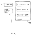
- FIG. 5 shows functionally a computer-implemented system depicted generally as 10 for designing transportation routes, comprising a computer 11 coupled to a memory 12 and a data output device 13 such as a display monitor, plotter, printer and the like.
- Transportation route data including:
Landscapes
- Engineering & Computer Science (AREA)
- Physics & Mathematics (AREA)
- Theoretical Computer Science (AREA)
- Geometry (AREA)
- General Physics & Mathematics (AREA)
- Business, Economics & Management (AREA)
- Strategic Management (AREA)
- Human Resources & Organizations (AREA)
- Computer Hardware Design (AREA)
- Entrepreneurship & Innovation (AREA)
- Economics (AREA)
- Educational Administration (AREA)
- Operations Research (AREA)
- General Engineering & Computer Science (AREA)
- Pure & Applied Mathematics (AREA)
- Mathematical Optimization (AREA)
- Development Economics (AREA)
- Mathematical Analysis (AREA)
- Computational Mathematics (AREA)
- Structural Engineering (AREA)
- Game Theory and Decision Science (AREA)
- Civil Engineering (AREA)
- Architecture (AREA)
- Marketing (AREA)
- Evolutionary Computation (AREA)
- Quality & Reliability (AREA)
- Tourism & Hospitality (AREA)
- General Business, Economics & Management (AREA)
- Road Paving Structures (AREA)
- Control Of Position, Course, Altitude, Or Attitude Of Moving Bodies (AREA)
- Management, Administration, Business Operations System, And Electronic Commerce (AREA)
- Train Traffic Observation, Control, And Security (AREA)
- Control By Computers (AREA)
- Pharmaceuticals Containing Other Organic And Inorganic Compounds (AREA)
- Hardware Redundancy (AREA)
- Ship Loading And Unloading (AREA)
Claims (15)
- Ein Computer-implementiertes Verfahren für die Auswahl einer Transportstrecke,
wobei das Verfahren die folgenden Schritte umfasst:(a) Bereitstellen linearer Bedingungen, die von der Transportstrecke erfüllt werden sollen;(b) Bereitstellen einer nicht-linearen Zielfunktion, wobei die nicht-lineare Zielfunktion Kosten einer Transportstrecke berechnet, wobei die Transportstrecke durch Unterschiede der Höhenlage zwischen Höhenlagen der Transportstrecke und bestehenden topographischen Höhenlagen an einem oder mehreren Gitterpunkten spezifiziert wird, wobei die Berechnung der Kosten Kosten pro Arbeitseinheit von Landabtragungsvorgängen und Kosten pro Arbeitseinheit von Landaufüllungsvorgängen beinhaltet; und(c) Bestimmen eines Satzes von einer oder mehreren linearen Zielfunktionen, wobei der Satz von linearen Zielfunktionen mit der nicht-linearen Zielfunktion äquivalent ist,
wobei die nicht-lineare Zielfunktion durch folgendes gegeben ist:
worin:G die Gittergröße ist;Zq = Z'q-Za wobei Z'q die Höhenlage der Transportstrecke ist und Za die bestehende topographische Höhenlage an dem Punkt Q ist;Fq(Zq) die Kosten der Auffüllung an dem Punkt Q sind, wobei Zq>0;Wq(Zq) die Kosten der Stützmauer für die Auffüllung an dem Punkt Q sind, wobei Zq>0;Cq(Zq) die Kosten der Abgrabung an dem Punkt Q sind, wobei Zq<0;Vq(Zq) die Kosten der Stützmauer für die Abgrabung an dem Punkt Q sind, wobei Zq<0; undD die Kosten des Gesamtunterschieds zwischen Volumina der Auffüllung und Abgrabung sind, die einen Bereich eines gesamten Straßensystems betreten oder verlassen,wobei die Kosten Cq(Zq) durch folgendes dargestellt sind:
wobei der Schritt des Bereitstellens einer oder mehrerer linearer Zielfunktionen das Ersetzen eines oder mehrerer der Ausdrücke Zq - ai, Zq - bl, Zq - cj, Zq - dj, Zq - ej, Zq - fj in der nicht-linearen Zielfunktion immer, wenn der eine oder mehrere Ausdrücke in der nicht-linearen Zielfunktion ohne Absolutwert auftreten, durch eine neue Variable umfasst, wobei:(a) Zq - ai ersetzt wird durch Uqai1 - Uqai2, i = 1,...,Kq;(b) Zq - bl ersetzt wird durch Uqbl1 - Uqbl2, i = 1,...,Kq;(c) Zq - bKq ersetzt wird durch UqbK1 - UqbK2;(d) Zq - cj ersetzt wird durch Uqc1 - Uqcj2, j = 1,...,L;(e) Zq - dj ersetzt wird durch Uqdj1 - Uqdj2, j = 1,...,L;(f) Zq - dL ersetzt wird durch UqdL1 - UqdL2;(g) Zq - ej ersetzt wird durch Uqej1 - Uqej2, j = 1,...,M;(h) Zq - fj ersetzt wird durch Uqfj1 - Uqfj2, j = 1,...,M; und(i) Zq - fM ersetzt wird durch UqfM1 - UqfM2; undwobei der Schritt des Bereitstellens einer oder mehrerer linearer Zielfunktionen ferner das Ersetzen eines oder mehrerer der Ausdrücke |Zq - ai|, |Zq - bi|, |Zq - cj|, |Zq - dj|, |Zq - ej|, |Zq - fj| in der nicht-linearen Zielfunktion durch eine neue Variable umfasst, wobei:(a) |Zq - ai| ersetzt wird durch Uqal1 + Uqal2, i = 1,...,Kq;(b) |Zq - bi| ersetzt wird durch Uqbl1 + Uqbi2, i = 1,...,Kq;(c) |Zq - bKq| ersetzt wird durch UqbK1 + UqbK2;(d) [Zq - cj| ersetzt wird durch Uqcj1 + Uqcj2, j = 1,...,L;(e) |Zq - dj| ersetzt wird durch Uqdj1 + UqdJ2, j = 1,...,L;(f) |Zq - dL| ersetzt wird durch UqdL1 + UqdL2;(g) |Zq - ej| ersetzt wird durch Uqej1 + Uqej2, j = 1,...,M;(h) |Zq -fj| ersetzt wird durch Uqfj1 + Uqfj2, j = 1,...,M; und(i) |Zq - fM| ersetzt wird durch UqfM1 + UqfM2. - Das Verfahren gemäß Anspruch 1, wobei die nicht-lineare Zielfunktion ferner die Bodenzusammensetzung und pro Einheit Abgrabungskosten für jedes unterschiedliche Niveau mit einer eigenständigen Bodenzusammensetzung beinhaltet.
- Das Verfahren gemäß Anspruch 1 oder 2, wobei mindestens eine der Transportstrecken eine oder mehrere Unterteilungsparzellen einschließt, die an einer Grenze der Transportstrecke anstoßen, und die nicht-lineare Zielfunktion ferner Abschnitte und Grenzen der Unterteilungsparzellen beinhaltet, um Erdarbeiten zu berücksichtigen, die zur Angleichung einer Höhenlage der Transportstrecke an entsprechende Höhenlagen der Unterteilungsparzellen erforderlich sind.
- Das Verfahren gemäß einem der vorstehenden Ansprüche, wobei die ausgewählte Transportstrecke mindestens eine Autostraße ein schließt.
- Das Verfahren gemäß einem der vorstehenden Ansprüche, wobei die ausgewählte Transportstrecke mindestens eine Eisenbahnlinie einschließt.
- Das Verfahren gemäß einem der vorstehende Ansprüche, wobei die ausgewählte Transportstrecke mindestens einen Fußgängerweg einschließt.
- Das Verfahren gemäß einem der vorstehenden Ansprüche, das auf eine Vielzahl von Transportstrecken, umfassend ein integriertes Projekt zur Optimierung der Abgrabungskosten für das Projekt, angewendet wird.
- Ein Computer-implementiertes System für die Auswahl einer Transportstrecke,
wobei das System einen Computer umfasst, der mit einem Speicher- und einer Datenausgabe-Vorrichtung gekoppelt ist,(g) wobei in dem Speicher Transportstrecken-Daten gespeichert sind, die folgendes einschließen:(i) lineare Bedingungen, die von der Transportstrecke erfüllt werden sollen;(ii) eine nicht-lineare Zielfunktion, wobei die nicht-lineare Zielfunktion Kosten einer Transportstrecke berechnet, wobei die Transportstrecke durch Unterschiede der Höhenlage zwischen Höhenlagen der Transportstrecke und bestehenden topographischen Höhenlagen an einem oder mehreren Gitterpunkten spezifiziert wird, wobei die Berechnung der Kosten Kosten pro Arbeitseinheit von Landabtragungsvorgängen und Kosten pro Arbeitseinheit von Landauffüllungsvorgängen beinhaltet;(h) der Computer für folgendes konfiguriert ist:(i) Bestimmen eines Satzes von einer oder mehreren linearen Zielfunktionen, wobei der Satz von linearen Zielfunktionen mit der nicht-linearen Zielfunktion äquivalent ist,wobei die Kosten Cq(Zq) durch folgendes dargestellt sind:
wobei die nicht-lineare Zielfunktion durch folgendes gegeben ist:
worin:G die Gittergröße ist;Zq = Z'q - Za, wobei Z'q die Höhenlage der Transportstrecke ist und Za die bestehende topographische Höhenlage an dem Punkt Q ist;q(Zq) F die Kosten der Auffüllung an dem Punkt Q sind, wobei Zq>0;Wq(Zq) die Kosten der Stützmauer für die Auffüllung an dem Punkt Q sind, wobei Zq>0;Cq(Zq) die Kosten der Abgrabung an dem Punkt Q sind, wobei Zq<0;Vq(Zq) die Kosten der Stützmauer für die Abgrabung an dem Punkt Q sind, wobei Zq<0; undD die Kosten des Gesamtunterschieds zwischen Volumina der Auffüllung und Abgrabung sind, die einen Bereich eines gesamten Straßensystems betreten oder verlassen,
wobei der Schritt des Bestimmens einer oder mehrerer linearer Zielfunktionen das Ersetzen eines oder mehrerer der Ausdrücke Zq - al, Zq - bl, Zq - Cj, Zq - dj, Zq - ej, Zq - fj in der nicht-linearen Zielfunktion immer, wenn der eine oder mehrere Ausdrücke in der nicht-linearen Zielfunktion ohne Absolutwert auftreten, durch eine neue Variable umfasst, wobei:(a) Zq - ai ersetzt wird durch Uqai1 - Uqai2; i = 1,...,Kq;(b) Zq - bi ersetzt wird durch Uqbi1 - Uqbi2, i = 1,...,Kq;(c) Zq - bKq ersetzt wird durch UqbK1 - UqbK2;(d) Zq - cj ersetzt wird durch Uqcj1 - Uqcj2, j = 1,...,L;(e) Zq - dj ersetzt wird durch Uqdj1 - Uqdj2, j = 1,...,L;(f) Zq - dL ersetzt wird durch UqdL1 - UqdL2;(g) Zq - ej ersetzt wird durch Uqej1 - Uqej2, j = 1,...,M;(h) Zq - fj ersetzt wird durch Uqfj1 - Uqfj2, j = 1,...,M; und(i) Zq - fM ersetzt wird durch UqfM1 - UqfM2; undwobei der Schritt des Bestimmens einer oder mehrerer linearer Zielfunktionen ferner das Ersetzen eines oder mehrerer der Ausdrücke |Zq - ai|, |Zq - bi|, |Zq - cj|, |Zq - dj|, [Zq - ej|, |Zq - fj| in der nicht-linearen Zielfunktion durch eine neue Variable umfasst, wobei:(a) |Zq - ai| ersetzt wird durch Uqai1 + Uqai2, i = 1,..,Kq;(b) |Zq - bi| ersetzt wird durch Uqbi1 + Uqbi2, i = 1,...,Kq;(c) |Zq - bkq| ersetzt wird durch UqbK1 + UqbK2;(d) |Zq - Cj| ersetzt wird durch Uqcj1 + Uqcj2, j = 1,...,L;(e) |Zq - dj| ersetzt wird durch Uqdj1 + Uqdj2, j = 1,...,L;(f) |Zq - dL| ersetzt wird durch UqdL1 + UqdL2;(g) |Zq - ej| ersetzt wird durch Uqej1 + Uqej2, j = 1,...,M;(h) |Zq - fj| ersetzt wird durch Uqfj1 + Uqfj2, j = 1,...,M; und(i) |Zq - fM| ersetzt wird durch UqfM1 + UqfM2. - Das System gemäß Anspruch 8, wobei die nicht lineare Zielfunktion ferner die Bodenzusammensetzung und pro Einheit Abgrabungskosten für jedes unterschiedliche Niveau mit einer eigenständigen Bodenzusammensetzung beinhaltet.
- Das System gemäß Anspruch 8 oder 9, wobei:mindestens eine der Transportstrecken eine oder mehrere Unterteilungsparzellen einschließt, die an einer Grenze der Transportstrecke anstoßen,in dem Speicher ferner Daten bezüglich jeweiliger Abschnitte und Grenzen der Unterteilungsparzellen gespeichert sind, unddie nicht-lineare Zielfunktion Abschnitte und Grenzen der Unterteilungsparzellen beinhaltet, um Erdarbeiten zu berücksichtigen, die zur Angleichung einer Höhenlage der Transportstrecke an entsprechende Höhenlagen der Unterteilungsparzellen erforderlich sind.
- Das System gemäß einem der Ansprüche 8 bis 10, wobei die ausgewählten Transportstrecken-Daten Daten bezüglich mindestens einer Autostraße einschließen.
- Das System gemäß einem der Ansprüche 8 bis 10, wobei die ausgewählten Transportstrecken-Daten Daten bezüglich mindestens einer Eisenbahnlinie einschließen.
- Das System gemäß einem der Ansprüche 8 bis 10, wobei die ausgewählten Transportstrecken-Daten Daten bezüglich mindestens einem Fußgängerweg einschließen.
- Das System gemäß einem der Ansprüche 8 bis 13 für die Verarbeitung von Daten bezüglich einer Vielzahl von Transportstrecken, umfassend ein integriertes Projekt zur Optimierung der Abgrabungskosten für das Projekt.
- Ein Speichermedium, das darin ein Computerprogramm für die Durchführung des Verfahrens gemäß einem der Ansprüche 1 bis 7 speichert.
Applications Claiming Priority (3)
| Application Number | Priority Date | Filing Date | Title |
|---|---|---|---|
| IL12696298A IL126962A (en) | 1998-11-09 | 1998-11-09 | Method and system for optimizing transportation route design |
| IL12696298 | 1998-11-09 | ||
| PCT/IL1999/000538 WO2000028448A1 (en) | 1998-11-09 | 1999-10-13 | Computer-implemented method and system for designing transportation routes |
Publications (2)
| Publication Number | Publication Date |
|---|---|
| EP1129422A1 EP1129422A1 (de) | 2001-09-05 |
| EP1129422B1 true EP1129422B1 (de) | 2008-08-20 |
Family
ID=11072121
Family Applications (1)
| Application Number | Title | Priority Date | Filing Date |
|---|---|---|---|
| EP99947834A Expired - Lifetime EP1129422B1 (de) | 1998-11-09 | 1999-10-13 | Computer-unterstütztes verfahren und system zum entwerfen von transportrouten |
Country Status (8)
| Country | Link |
|---|---|
| US (1) | US6996507B1 (de) |
| EP (1) | EP1129422B1 (de) |
| AT (1) | ATE405891T1 (de) |
| AU (1) | AU763677B2 (de) |
| CA (1) | CA2349820A1 (de) |
| DE (1) | DE69939395D1 (de) |
| IL (1) | IL126962A (de) |
| WO (1) | WO2000028448A1 (de) |
Cited By (1)
| Publication number | Priority date | Publication date | Assignee | Title |
|---|---|---|---|---|
| CN109447437A (zh) * | 2018-10-17 | 2019-03-08 | 中南大学 | 一种包含土石方调配的公(铁)路纵断面自动构建方法 |
Families Citing this family (37)
| Publication number | Priority date | Publication date | Assignee | Title |
|---|---|---|---|---|
| JP3685249B2 (ja) * | 2000-02-21 | 2005-08-17 | オリジナル設計株式会社 | 3次元構造物設計システム、3次元構造物設計方法およびその方法をコンピュータに実行させるプログラムを記録したコンピュータ読み取り可能な記録媒体 |
| US7551180B2 (en) * | 2004-03-18 | 2009-06-23 | Bentley System, Inc. | Graphical end conditions for roadway design |
| US7599820B2 (en) * | 2005-06-23 | 2009-10-06 | Autodesk, Inc. | Graphical user interface for interactive construction of typical cross-section frameworks |
| US20070233542A1 (en) * | 2006-04-04 | 2007-10-04 | Conception Design Ware, Inc. | Method and system for designing, executing and managing road construction projects |
| US7917292B1 (en) * | 2006-10-17 | 2011-03-29 | Jpmorgan Chase Bank, N.A. | Systems and methods for flood risk assessment |
| US8144245B2 (en) * | 2007-02-28 | 2012-03-27 | Caterpillar Inc. | Method of determining a machine operation using virtual imaging |
| CA2684667C (en) | 2007-04-20 | 2014-02-25 | Mark Williams | Vertical curve system for surface grading |
| US20090198505A1 (en) * | 2008-02-05 | 2009-08-06 | Peter Gipps | Interactive path planning with dynamic costing |
| WO2010060180A1 (en) * | 2008-11-26 | 2010-06-03 | Transoft Solutions, Inc. | Method and apparatus for displaying a representation of a traffic intersection |
| US20130110472A1 (en) * | 2010-06-22 | 2013-05-02 | Transoft Solutions ,Inc. | Method and apparatus for generating a geometric layout of a traffic intersection |
| US10606962B2 (en) * | 2011-09-27 | 2020-03-31 | Autodesk, Inc. | Horizontal optimization of transport alignments |
| US9799045B2 (en) | 2012-04-27 | 2017-10-24 | Softree Technical Systems, Inc. | Method and system for determining the vertical alignment of an infrastructure corridor |
| US20150193562A1 (en) * | 2012-06-20 | 2015-07-09 | Transoft Solutions, Inc. | Method and apparatus for computer generation of a geometric layout representing a central island of a traffic roundabout |
| US9886527B2 (en) * | 2013-01-16 | 2018-02-06 | Autodesk, Inc. | Determining feasible splines with engineering constraints using projection methods |
| US10546400B2 (en) | 2015-06-03 | 2020-01-28 | Here Global B.V. | Method and apparatus for defining bi-directional road geometry from probe data |
| US10444020B2 (en) * | 2015-06-03 | 2019-10-15 | Here Global B.V. | Method and apparatus for defining road geometry from probe data |
| US11783248B2 (en) * | 2015-06-23 | 2023-10-10 | Komatsu Ltd. | United states construction management system and method |
| JP6578366B2 (ja) * | 2015-10-05 | 2019-09-18 | 株式会社小松製作所 | 施工管理システム |
| JP6567940B2 (ja) * | 2015-10-05 | 2019-08-28 | 株式会社小松製作所 | 施工管理システム |
| CN106469238A (zh) * | 2016-08-31 | 2017-03-01 | 中南大学 | 公路三维线形的一致性评价方法和装置 |
| GB2570119B (en) * | 2018-01-10 | 2022-06-08 | Ocado Innovation Ltd | A controller and method for transporting devices |
| US10747230B2 (en) * | 2018-10-08 | 2020-08-18 | Mando Corporation | Vehicle control apparatus, vehicle control system, and image sensor |
| CN109671150B (zh) * | 2018-12-06 | 2023-01-31 | 西安西北民航项目管理有限公司 | 基于数字地球的机场土方计算方法 |
| CN111898869A (zh) * | 2020-07-07 | 2020-11-06 | 舜元建设(集团)有限公司 | 一种结合倾斜摄影、rtk和bim技术的土石方测量计算方法 |
| CN112883474B (zh) * | 2021-03-02 | 2021-09-24 | 中南大学 | 一种既有轨道线路智能改建的布设方法、系统、终端及可读存储介质 |
| DE102021107904A1 (de) * | 2021-03-29 | 2022-09-29 | Conti Temic Microelectronic Gmbh | Verfahren und System zur Bestimmung der Bodenebene mit einem künstlichen neuronalen Netz |
| CN113505414B (zh) * | 2021-06-08 | 2024-06-07 | 广州地铁设计研究院股份有限公司 | 地铁线路纵断面设计方法、系统、设备及存储介质 |
| CN216987814U (zh) * | 2022-01-27 | 2022-07-19 | 宁波厨聚厨房科技有限公司 | 一种小型研磨机 |
| CN115270459B (zh) * | 2022-07-26 | 2026-02-24 | 中交第二公路勘察设计研究院有限公司 | 一种基于多层三维模型的公路改扩建路面拼宽自动算量方法 |
| JP7839710B2 (ja) * | 2022-09-08 | 2026-04-02 | 株式会社 三英技研 | トンネル坑口検討支援システム及びトンネル坑口検討支援プログラム |
| US12554917B1 (en) * | 2023-02-03 | 2026-02-17 | Cadence Design Systems, Inc. | Etching shape insertion based on spacing rule |
| CN116451307A (zh) * | 2023-03-13 | 2023-07-18 | 深圳京昌水务科技有限公司 | 道路模型建立方法、装置、设备及存储介质 |
| CN116227888B (zh) * | 2023-05-05 | 2023-07-28 | 山东大学 | 考虑路段内线路不交叉约束的城市配电网规划方法及系统 |
| CN118296716B (zh) * | 2024-06-06 | 2024-08-16 | 中国市政工程西南设计研究总院有限公司 | 一种基于栅格数据的道路形态信息建模识别方法 |
| CN119577900B (zh) * | 2024-11-19 | 2025-09-30 | 佛山轨道交通设计研究院有限公司 | 一种轨道交通线路与区间纵断面控制点智能化标注方法 |
| CN119227218B (zh) * | 2024-12-05 | 2025-04-08 | 民航机场规划设计研究总院有限公司 | 融合业务场景下机场土方的一体化计算方法和设备 |
| CN121562036B (zh) * | 2026-01-23 | 2026-04-17 | 福建理工大学 | 一种基于分层存档差分进化算法的地铁轨道线路智能优化方法 |
Family Cites Families (5)
| Publication number | Priority date | Publication date | Assignee | Title |
|---|---|---|---|---|
| US5574841A (en) * | 1991-08-05 | 1996-11-12 | Calligraphic Systems Limited | Apparatus and method for three-dimensional powerline designing and maintenance |
| US5375663A (en) | 1993-04-01 | 1994-12-27 | Spectra-Physics Laserplane, Inc. | Earthmoving apparatus and method for grading land providing continuous resurveying |
| ZA948824B (en) | 1993-12-08 | 1995-07-11 | Caterpillar Inc | Method and apparatus for operating geography altering machinery relative to a work site |
| US5517428A (en) | 1994-05-02 | 1996-05-14 | Williams; David | Optimizing a piping system |
| US5745751A (en) | 1996-04-12 | 1998-04-28 | Nelson; Robert W. | Civil site information system |
-
1998
- 1998-11-09 IL IL12696298A patent/IL126962A/xx not_active IP Right Cessation
-
1999
- 1999-10-13 AU AU61195/99A patent/AU763677B2/en not_active Ceased
- 1999-10-13 DE DE69939395T patent/DE69939395D1/de not_active Expired - Lifetime
- 1999-10-13 AT AT99947834T patent/ATE405891T1/de not_active IP Right Cessation
- 1999-10-13 US US09/831,093 patent/US6996507B1/en not_active Expired - Lifetime
- 1999-10-13 CA CA002349820A patent/CA2349820A1/en not_active Abandoned
- 1999-10-13 WO PCT/IL1999/000538 patent/WO2000028448A1/en not_active Ceased
- 1999-10-13 EP EP99947834A patent/EP1129422B1/de not_active Expired - Lifetime
Cited By (1)
| Publication number | Priority date | Publication date | Assignee | Title |
|---|---|---|---|---|
| CN109447437A (zh) * | 2018-10-17 | 2019-03-08 | 中南大学 | 一种包含土石方调配的公(铁)路纵断面自动构建方法 |
Also Published As
| Publication number | Publication date |
|---|---|
| IL126962A (en) | 1999-12-22 |
| US6996507B1 (en) | 2006-02-07 |
| EP1129422A1 (de) | 2001-09-05 |
| AU763677B2 (en) | 2003-07-31 |
| AU6119599A (en) | 2000-05-29 |
| CA2349820A1 (en) | 2000-05-18 |
| ATE405891T1 (de) | 2008-09-15 |
| DE69939395D1 (de) | 2008-10-02 |
| WO2000028448A1 (en) | 2000-05-18 |
Similar Documents
| Publication | Publication Date | Title |
|---|---|---|
| EP1129422B1 (de) | Computer-unterstütztes verfahren und system zum entwerfen von transportrouten | |
| de Lima et al. | Distribution of materials in road earthmoving and paving: mathematical programming approach | |
| US8321181B2 (en) | Computer-implemented land planning system and method | |
| Moselhi et al. | Optimization of earthmoving operations in heavy civil engineering projects | |
| Lee et al. | Flexible 3D model partitioning system for nD-based BIM implementation of alignment-based civil infrastructure | |
| Son et al. | Determination of haul distance and direction in mass excavation | |
| Jeonghwan et al. | 3D earthwork BIM design and its application in an advanced construction equipment operation | |
| KR102130922B1 (ko) | 3차원 Surface 지형 및 도로(Corridor) 구조물의 위치별 구간(Station) 및 객체 정보의 자동추출을 통한 구간(Station)별 3차원 Solid 절토(Cut)/성토(Fill) 지형과 도로(Corridor) 구조물 객체 자동변환 및 물량 자동생성 시스템 및 방법 | |
| KR102521409B1 (ko) | 3차원 디지털 모델을 활용한 교량 설계 시스템 | |
| KR102523858B1 (ko) | 프리팹 교량의 설계를 위한 3d 교량 설계 시스템 | |
| Goktepe et al. | Method for optimizing earthwork considering soil properties in the geometric design of highways | |
| US20070233542A1 (en) | Method and system for designing, executing and managing road construction projects | |
| JP2001325310A (ja) | 下水道敷設設計支援システム及び記録媒体 | |
| Moreb et al. | Quadratic representation for roadway profile that minimizes earthwork cost | |
| CN118520575B (zh) | 一种公路工程道路专业构件参数化建模方法及系统 | |
| De Lima et al. | Optimization of earthmoving operations planning: a novel approach considering interferences | |
| CN119026214A (zh) | 一种基于bim的高陡边坡防护设计方法及系统 | |
| A'la | The BIM Implementation for Preparing Mutual Check-0 (MC-0) Documents in the Building Development Project of Edusmart Soerojo Hospital Magelang | |
| Akay et al. | The evolution of computer-aided road design systems | |
| Tanoli et al. | PAD based 3D earthwork BIM design module for machine guidance | |
| Trovato et al. | Reinforced soil structures: from standard design to BIM | |
| Bruce et al. | ACCEL: Spreadsheet-based cost estimation for forest road construction | |
| CN101405771A (zh) | 计算机实现的土地规划系统和方法 | |
| Ansari et al. | Calculation of Quantity of Earthwork and Generating Sectional Drawings with–Robust Software CSx | |
| Panchenko et al. | Innovative methods of using laser scanning and geoinformation systems for design of communication routes |
Legal Events
| Date | Code | Title | Description |
|---|---|---|---|
| PUAI | Public reference made under article 153(3) epc to a published international application that has entered the european phase |
Free format text: ORIGINAL CODE: 0009012 |
|
| 17P | Request for examination filed |
Effective date: 20010608 |
|
| AK | Designated contracting states |
Kind code of ref document: A1 Designated state(s): AT BE CH CY DE DK ES FI FR GB GR IE IT LI LU MC NL PT SE |
|
| GRAP | Despatch of communication of intention to grant a patent |
Free format text: ORIGINAL CODE: EPIDOSNIGR1 |
|
| RIC1 | Information provided on ipc code assigned before grant |
Ipc: G06F 17/50 20060101AFI20071022BHEP |
|
| GRAS | Grant fee paid |
Free format text: ORIGINAL CODE: EPIDOSNIGR3 |
|
| GRAA | (expected) grant |
Free format text: ORIGINAL CODE: 0009210 |
|
| AK | Designated contracting states |
Kind code of ref document: B1 Designated state(s): AT BE CH CY DE DK ES FI FR GB GR IE IT LI LU MC NL PT SE |
|
| REG | Reference to a national code |
Ref country code: GB Ref legal event code: FG4D |
|
| REG | Reference to a national code |
Ref country code: CH Ref legal event code: EP |
|
| REG | Reference to a national code |
Ref country code: IE Ref legal event code: FG4D |
|
| REF | Corresponds to: |
Ref document number: 69939395 Country of ref document: DE Date of ref document: 20081002 Kind code of ref document: P |
|
| PG25 | Lapsed in a contracting state [announced via postgrant information from national office to epo] |
Ref country code: NL Free format text: LAPSE BECAUSE OF FAILURE TO SUBMIT A TRANSLATION OF THE DESCRIPTION OR TO PAY THE FEE WITHIN THE PRESCRIBED TIME-LIMIT Effective date: 20080820 Ref country code: ES Free format text: LAPSE BECAUSE OF FAILURE TO SUBMIT A TRANSLATION OF THE DESCRIPTION OR TO PAY THE FEE WITHIN THE PRESCRIBED TIME-LIMIT Effective date: 20081201 |
|
| PG25 | Lapsed in a contracting state [announced via postgrant information from national office to epo] |
Ref country code: FI Free format text: LAPSE BECAUSE OF FAILURE TO SUBMIT A TRANSLATION OF THE DESCRIPTION OR TO PAY THE FEE WITHIN THE PRESCRIBED TIME-LIMIT Effective date: 20080820 Ref country code: AT Free format text: LAPSE BECAUSE OF FAILURE TO SUBMIT A TRANSLATION OF THE DESCRIPTION OR TO PAY THE FEE WITHIN THE PRESCRIBED TIME-LIMIT Effective date: 20080820 |
|
| PG25 | Lapsed in a contracting state [announced via postgrant information from national office to epo] |
Ref country code: BE Free format text: LAPSE BECAUSE OF FAILURE TO SUBMIT A TRANSLATION OF THE DESCRIPTION OR TO PAY THE FEE WITHIN THE PRESCRIBED TIME-LIMIT Effective date: 20080820 |
|
| PG25 | Lapsed in a contracting state [announced via postgrant information from national office to epo] |
Ref country code: DK Free format text: LAPSE BECAUSE OF FAILURE TO SUBMIT A TRANSLATION OF THE DESCRIPTION OR TO PAY THE FEE WITHIN THE PRESCRIBED TIME-LIMIT Effective date: 20080820 |
|
| PG25 | Lapsed in a contracting state [announced via postgrant information from national office to epo] |
Ref country code: PT Free format text: LAPSE BECAUSE OF FAILURE TO SUBMIT A TRANSLATION OF THE DESCRIPTION OR TO PAY THE FEE WITHIN THE PRESCRIBED TIME-LIMIT Effective date: 20090120 Ref country code: MC Free format text: LAPSE BECAUSE OF NON-PAYMENT OF DUE FEES Effective date: 20081031 |
|
| REG | Reference to a national code |
Ref country code: CH Ref legal event code: PL |
|
| PLBE | No opposition filed within time limit |
Free format text: ORIGINAL CODE: 0009261 |
|
| STAA | Information on the status of an ep patent application or granted ep patent |
Free format text: STATUS: NO OPPOSITION FILED WITHIN TIME LIMIT |
|
| 26N | No opposition filed |
Effective date: 20090525 |
|
| PG25 | Lapsed in a contracting state [announced via postgrant information from national office to epo] |
Ref country code: IT Free format text: LAPSE BECAUSE OF FAILURE TO SUBMIT A TRANSLATION OF THE DESCRIPTION OR TO PAY THE FEE WITHIN THE PRESCRIBED TIME-LIMIT Effective date: 20080820 |
|
| PG25 | Lapsed in a contracting state [announced via postgrant information from national office to epo] |
Ref country code: LI Free format text: LAPSE BECAUSE OF NON-PAYMENT OF DUE FEES Effective date: 20081031 Ref country code: IE Free format text: LAPSE BECAUSE OF NON-PAYMENT OF DUE FEES Effective date: 20081013 Ref country code: CH Free format text: LAPSE BECAUSE OF NON-PAYMENT OF DUE FEES Effective date: 20081031 |
|
| PG25 | Lapsed in a contracting state [announced via postgrant information from national office to epo] |
Ref country code: SE Free format text: LAPSE BECAUSE OF FAILURE TO SUBMIT A TRANSLATION OF THE DESCRIPTION OR TO PAY THE FEE WITHIN THE PRESCRIBED TIME-LIMIT Effective date: 20081120 |
|
| REG | Reference to a national code |
Ref country code: HK Ref legal event code: WD Ref document number: 1038803 Country of ref document: HK |
|
| PG25 | Lapsed in a contracting state [announced via postgrant information from national office to epo] |
Ref country code: LU Free format text: LAPSE BECAUSE OF NON-PAYMENT OF DUE FEES Effective date: 20081013 |
|
| PG25 | Lapsed in a contracting state [announced via postgrant information from national office to epo] |
Ref country code: CY Free format text: LAPSE BECAUSE OF FAILURE TO SUBMIT A TRANSLATION OF THE DESCRIPTION OR TO PAY THE FEE WITHIN THE PRESCRIBED TIME-LIMIT Effective date: 20080820 |
|
| PG25 | Lapsed in a contracting state [announced via postgrant information from national office to epo] |
Ref country code: GR Free format text: LAPSE BECAUSE OF FAILURE TO SUBMIT A TRANSLATION OF THE DESCRIPTION OR TO PAY THE FEE WITHIN THE PRESCRIBED TIME-LIMIT Effective date: 20081121 |
|
| PGFP | Annual fee paid to national office [announced via postgrant information from national office to epo] |
Ref country code: DE Payment date: 20101006 Year of fee payment: 12 |
|
| PGFP | Annual fee paid to national office [announced via postgrant information from national office to epo] |
Ref country code: GB Payment date: 20101013 Year of fee payment: 12 |
|
| PGFP | Annual fee paid to national office [announced via postgrant information from national office to epo] |
Ref country code: FR Payment date: 20111103 Year of fee payment: 13 |
|
| GBPC | Gb: european patent ceased through non-payment of renewal fee |
Effective date: 20121013 |
|
| REG | Reference to a national code |
Ref country code: FR Ref legal event code: ST Effective date: 20130628 |
|
| PG25 | Lapsed in a contracting state [announced via postgrant information from national office to epo] |
Ref country code: GB Free format text: LAPSE BECAUSE OF NON-PAYMENT OF DUE FEES Effective date: 20121013 Ref country code: DE Free format text: LAPSE BECAUSE OF NON-PAYMENT OF DUE FEES Effective date: 20130501 |
|
| REG | Reference to a national code |
Ref country code: DE Ref legal event code: R119 Ref document number: 69939395 Country of ref document: DE Effective date: 20130501 |
|
| PG25 | Lapsed in a contracting state [announced via postgrant information from national office to epo] |
Ref country code: FR Free format text: LAPSE BECAUSE OF NON-PAYMENT OF DUE FEES Effective date: 20121031 |