EP1085484A2 - Route display device for a navigation system - Google Patents
Route display device for a navigation system Download PDFInfo
- Publication number
- EP1085484A2 EP1085484A2 EP00308027A EP00308027A EP1085484A2 EP 1085484 A2 EP1085484 A2 EP 1085484A2 EP 00308027 A EP00308027 A EP 00308027A EP 00308027 A EP00308027 A EP 00308027A EP 1085484 A2 EP1085484 A2 EP 1085484A2
- Authority
- EP
- European Patent Office
- Prior art keywords
- route
- database
- navigation system
- map
- information
- Prior art date
- Legal status (The legal status is an assumption and is not a legal conclusion. Google has not performed a legal analysis and makes no representation as to the accuracy of the status listed.)
- Withdrawn
Links
Images




Classifications
-
- G—PHYSICS
- G01—MEASURING; TESTING
- G01C—MEASURING DISTANCES, LEVELS OR BEARINGS; SURVEYING; NAVIGATION; GYROSCOPIC INSTRUMENTS; PHOTOGRAMMETRY OR VIDEOGRAMMETRY
- G01C21/00—Navigation; Navigational instruments not provided for in groups G01C1/00 - G01C19/00
- G01C21/26—Navigation; Navigational instruments not provided for in groups G01C1/00 - G01C19/00 specially adapted for navigation in a road network
- G01C21/34—Route searching; Route guidance
- G01C21/3453—Special cost functions, i.e. other than distance or default speed limit of road segments
- G01C21/3476—Special cost functions, i.e. other than distance or default speed limit of road segments using point of interest [POI] information, e.g. a route passing visible POIs
-
- G—PHYSICS
- G01—MEASURING; TESTING
- G01C—MEASURING DISTANCES, LEVELS OR BEARINGS; SURVEYING; NAVIGATION; GYROSCOPIC INSTRUMENTS; PHOTOGRAMMETRY OR VIDEOGRAMMETRY
- G01C21/00—Navigation; Navigational instruments not provided for in groups G01C1/00 - G01C19/00
- G01C21/26—Navigation; Navigational instruments not provided for in groups G01C1/00 - G01C19/00 specially adapted for navigation in a road network
- G01C21/34—Route searching; Route guidance
- G01C21/3453—Special cost functions, i.e. other than distance or default speed limit of road segments
- G01C21/3484—Personalized, e.g. from learned user behaviour or user-defined profiles
-
- G—PHYSICS
- G01—MEASURING; TESTING
- G01C—MEASURING DISTANCES, LEVELS OR BEARINGS; SURVEYING; NAVIGATION; GYROSCOPIC INSTRUMENTS; PHOTOGRAMMETRY OR VIDEOGRAMMETRY
- G01C21/00—Navigation; Navigational instruments not provided for in groups G01C1/00 - G01C19/00
- G01C21/26—Navigation; Navigational instruments not provided for in groups G01C1/00 - G01C19/00 specially adapted for navigation in a road network
- G01C21/34—Route searching; Route guidance
- G01C21/36—Input/output arrangements for on-board computers
- G01C21/3667—Display of a road map
- G01C21/3676—Overview of the route on the road map
Definitions
- the present invention relates to a system for displaying a route from a start point to a destination in a map image read from a database and displayed, thereby navigating people.
- map information retrieving display system such as an electronic dictionary for map information developed for an information retrieving equipment and a server for map information provision connected to Internet has been improved with the spread of the information retrieving equipment such as a microcomputer and the rapid expansion of an information providing service to be provided through the internet.
- the map information retrieving display system is utilized by inputting a land mark such as an address or the name of facilities, retrieving map data on a desirable area from an electronic dictionary set up to the information retrieving equipment and a database of a server for map information provision which is connected through the internet, and displaying a map image of the map data in a display section and printing the map image.
- the present applicant has proposed a route information providing system for displaying the shortest route connecting a starting point and a destination which are specified on a map image through map data on a desirable area retrieved from the database in the prior application (JP-A-10-102512).
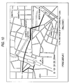
- the route information providing system previously stores route information in route computing database, carries out route computation based on the route information retrieved from the route computing database when the JR Kamata Station is specified as a starting point S and the Keikyu Kamata Station is specified as a destination G on a map image shown in Fig. 10, for example, displays the shortest route L giving priority to a highway connecting the starting point S and the destination G together with character data indicative of a total distance through a coloring (road coloring) method, thereby navigating people.
- the route information providing system in the prior proposal has an excellent feature that a user can easily get the route information indicative of the shortest route from the starting point to the desirable destination.
- the user wants to select a route capable of achieving a desirable object on the route from the starting point to the destination in place of the shortest route depending on circumstances.
- the user wants to take a meal, do shopping or do things in a banking agency during a movement from the starting point to the destination and a store for this purpose is not positioned along a highway but on a back street in some cases.
- the user wants to select a route to the destination depending on circumstances such as a weather.
- the user's requests are varied depending on various causes such as the user's age, sex and hobby, and is changed depending on circumstances such as a day of the week, a time zone or a weather.
- the invention has been made to meet the user's demand for the route information providing system.
- a first aspect of the invention is directed to a man navigation system comprising map display means for retrieving map data on a required area from a database and displaying a map image based on the retrieved map data, point specifying means for optionally specifying a first point and a second point in the map image displayed by the map display means, condition setting means for setting a condition for route setting, route setting means for setting a route connecting the first point and the second point in the map image specified by the point specifying means based on the condition set by the condition setting means, and route display means for displaying the route set by the route setting means on the map image displayed by the map display means.
- a route connecting the first point and the second point which is optionally specified by the point specifying means, that is, a starting point and a destination which is set by the route setting means based on the condition set by the condition setting means is displayed by the route display means on the map image displayed by the map display means.
- the route setting means sets a route to pass through a store corresponding to the user's hobby.
- the condition setting means is to set, as a route set condition, at least one condition such as a time and time zone that the user utilizes the route connecting the first point and the second point, a weather, a season or a climate, route setting is carried out corresponding to various route setting conditions, for example, a route in which an arcade is provided or a route passing through large facilities is set.
- the user can display the route set corresponding to the route setting condition on the map image displayed on a display such as a terminal equipment, thereby receiving navigation while seeing the displayed route.
- the shortest route is not simply set but the route is set corresponding to a condition set for each user, for example, the user's hobby or depending on a time zone for utilization and a weather. Therefore, a route to meet the user's demand can be set for navigation at each time.
- the facilities can be specified for an advertisement provider.
- the man navigation system can also be utilized as an advertisement medium.
- a second aspect of the invention is directed to the man navigation system wherein the condition setting means sets a route setting condition based on user information including a user's sex, age, character, hobby and preference.
- a route passing through facilities such as a store dealing in goods adapted to the user's sex, age and hobby, for example, is set based on user information which is previously registered or is input during route setting.
- the shortest route is not simply set but a route corresponding to each user's preference is set. Consequently, the navigation can be carried out while guiding the user to a more useful route.
- a new discovery of the area can be given to the user.
- commercial utilization such as an increase in a purchasing will can also be obtained.
- a third aspect of the invention is directed to the man navigation system wherein the user information is previously recorded in a user registration database and the condition setting means sets the route setting condition by reading the user information from the user registration database.
- the route setting condition is set by the condition setting means based on the user information previously recorded in the user registration database.
- the user can automatically receive the navigation through the man navigation system according to a route meeting the user's preference based on the user information read from the user registration database.
- a fourth aspect of the invention is directed to the man navigation system wherein the condition setting means sets, as the route setting condition, at least one condition such as a time and time zone that the user utilizes the route connecting the first point and the second point, a weather, a season or a climate.
- a route is set based on at least one condition such as a time and time zone, a weather, a season or a climate when the user is to receive the navigation.
- the time and time zone that the user is to receive the navigation is a time for a meal
- the route connecting the specified first point (starting point) and second point (destination) is to be displayed on the map image to navigate a man, it is possible to navigate the man through a more useful route than the case in which the man is simply navigated through the shortest route.
- a fifth aspect of the invention is directed to the man navigation system wherein the route setting means has facility information database storing information about facilities positioned in the map image displayed by the map display means, retrieves the facilities corresponding to the user information from the facility information database, and selects a route including the retrieved facilities as a set route.
- the route setting means when the route setting means is to set a route based on the user information in the second aspect of the invention, facilities corresponding to the user information are retrieved from the facility information database previously storing information about facilities positioned in the map image.
- the facilities corresponding to the user information can be retrieved easily arid the facilities having information stored in the facility information database are set to have advertisement provision. Consequently, the man navigation system can also be utilized as an advertisement medium.
- a sixth aspect of the invention is directed to the man navigation system wherein the route setting means has facility information database storing information about facilities positioned in the map image displayed by the map display means, retrieves, from the facility information database, the facilities corresponding to at least one condition such as the time and time zone, the weather, the season or the climate which is set as the route setting condition by the condition setting means, and selects a route including the retrieved facilities as a set route.
- the route setting means has facility information database storing information about facilities positioned in the map image displayed by the map display means, retrieves, from the facility information database, the facilities corresponding to at least one condition such as the time and time zone, the weather, the season or the climate which is set as the route setting condition by the condition setting means, and selects a route including the retrieved facilities as a set route.
- the route setting means when the route setting means is to set a route based on the condition such as a time for utilization of navigation or a weather in the fourth aspect of the invention, facilities adapted to the condition are retrieved from the facility information database previously storing information about the facilities positioned in the map image.
- the facilities adapted to the time for utilization and the weather can be retrieved easily and the facilities having information stored in the facility information database are set to have advertisement provision, for example. Consequently, the man navigation system can also be utilized as an advertisement medium.
- a seventh aspect of the invention is directed to the man navigation system wherein the facility information stored in the facility information database is recorded based on a request of an advertisement provider.
- the route setting means sets a route based on a position where the facilities of an advertisement provider are located. Consequently, the advertisement provider can utilize the man navigation system as an advertisement medium. Thus, the man navigation system can be increasingly utilized commercially.
- an eighth aspect of the invention is directed to the man navigation system wherein the route setting means has a route database storing information about a route on the map image displayed by the map display means and sets a route based on the route information retrieved from the route database.
- the route database stores information about a route on the map image.
- the route setting means When the route setting means is to set a route based on the route setting condition, it retrieves, from the route database, information about a route to be set, for example, information such as the presence of an arcade, positions of entrances and exits of large facilities, identification of right and left of a sidewalk provided on both sides of a road and the position of a crosswalk.
- a ninth aspect of the invention is directed to the man navigation system wherein the route information stored in the route database is related to presence of an arcade.
- the route setting means is to set a route as the route setting conditions
- a road having an arcade provided thereover is selected to set a route in case of the rain. Consequently, it is possible to carry out navigation to guide the user to such a route as not to get wet in the rain.
- a tenth aspect of the invention is directed to the man navigation system wherein the route information stored in the route database is related to positions of entrances and exits of large facilities.
- the route setting means in the case in which the route setting means is to set a route by using the weather as the route setting condition, it sets a routs passing through large facilities in which an umbrella is not required in case of the rain or fair midsummer and provide a cool state through high air-conditioning. Consequently, it is possible to carry out navigation to guide the user to a more useful route than a movement in the shortest distance.
- an eleventh aspect of the invention is directed to the man navigation system wherein the route information stored in the route database is related to a position of a sidewalk provided on both sides of a road.
- the facilities adapted to the route setting condition such as user information face a road having a sidewalk provided on both sides
- a twelfth aspect of the invention is directed to the man navigation system wherein the route information stored in the route database is related to a position of a crosswalk provided on a road.
- the man navigation system in accordance with the twelfth aspect of the invention for example, in the case in which the user crosses the crosswalk, it is possible to carry out navigation through such fine route setting as to reach, at the shortest distance, the facilities in the crosswalk provided on the intersection which are adapted to the user information.
- a thirteenth aspect of the invention is directed to the man navigation system wherein the route display means displays the facilities retrieved from the facility information database to be distinguished from other facilities on the map image displayed by the map display means.
- the facilities adapted to the user information retrieved as the route setting condition or the weather are displayed on the route set in the map image through expansion, coloring or flashing such that they can be distinguished from other facilities. Consequently, the user can utilize the facilities easily.
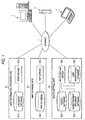
- Fig. 1 is a diagram showing a structure of a map information retrieving system according to an embodiment of the invention.
- a terminal equipment T is connected to an internet I through a public telephone network and an access server which are not shown, and a map information providing side S1, a map information database site S2 and a route setting site S3 are connected to the internet I, respectively.
- the map information providing site S1 serves to give a providing service for map information through a WWW (World Wide Web) and generalizes the information provision, to a terminal equipment T, from a map database site S2 and a route setting site S3 which will be described below.
- WWW World Wide Web
- the map information providing site S1 includes a WWW server S1a and a land mark database S1b storing a land mark such as an address or facilities and data indicative of their position information.
- the WWW server S1a accesses the land mark database S1b based on information input from the terminal equipment T, thereby specifying the landmark such as an address or facilities from the input position information or acquiring corresponding position information from the specified land mark, which will be described below.
- the map database site S2 serves to give a retrieving display service for map information on the internet, and includes a map server S2a for reading map data and transmitting the map data to the terminal equipment T and a map information database S2b storing position information indicative of coordinates through a latitude and a longitude, map display information such as a reduced scale or a map size and image data on a map corresponding to these information.
- the route setting site S3 serves to set an optimum route adapted to the conditions set by each user in a route connecting a starting point and a destination which are specified by the user through the terminal equipment T, and includes a route setting server S3a storing a program for route setting, a route database S3b recording vector data indicative of a road on a map which are required for the route setting by the route setting server S3a, an advertisement provider database S3c recording registration data of an advertisement provider such as a store or a shop, and a user registration database S3d recording user information.
- the route database S3b of the route setting site S3 stores all information about a road, for example, information about a road required for route setting such as the type of the road, for example, a general road, a special road for cars or a special road for pedestrians, the identification of right and left sidewalks provided on the road, the positions of a signal and a crosswalk at an intersection, the presence of an arcade and the positions of entrances and exits which face various roads in a large store, for example, a department store.
- a road required for route setting such as the type of the road, for example, a general road, a special road for cars or a special road for pedestrians, the identification of right and left sidewalks provided on the road, the positions of a signal and a crosswalk at an intersection, the presence of an arcade and the positions of entrances and exits which face various roads in a large store, for example, a department store.
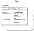
- the advertisement provider database S3c records registration data on an advertisement provider such as a store or shop association which provides an advertisement in the form of a customer file f shown in Fig. 2.
- the customer file f records, for each advertisement provider, data on a position of a store on a map required for the route setting carried out by the route setting server S3a, a type of industry, goods to be dealt and a business hour, which will be described below.
- the user registration database 53d records, for each user, information which utilizes the man navigation system and is previously registered, for example, information required for the route setting such as a sex, an age, a hobby, a preference and a hometown.
- the terminal equipment T is a user terminal capable of receiving a WWW service by using an application program referred to as a WWW browser.
- a portable telephone having a so-called i mode function and PDA (Personal Digital Assistants) including a portable terminal such as a mobile are used in addition to a personal computer.
- PDA Personal Digital Assistants
- a user which wants to receive the provision of navigation information from the man navigation system connects the terminal equipment T to the internet I through a public telephone network and an access server, and specifies a URL (Uniform Resource Locator) of the map information providing site S1 through the WWW browser set up to the terminal equipment T (Step s1).
- a URL Uniform Resource Locator
- the map information providing site S1 transmits, to the terminal equipment T, an image through a HTML (Hyper Text Makeup Language) text of a home page for providing navigation information and displays the image based on the specification of the URL through the terminal equipment T (Step s2).
- HTML Hyper Text Makeup Language
- the user inputs an ID and a password for specifying the user on the home page displayed on a display of the terminal equipment T and specifies a starting point and a destination which are to be navigated (Step s3).
- Step s3 moreover, if there are additional conditions for the route setting, for example, conditions other than set conditions included in the user information which are previously registered on the user registration database S3d of the route setting site S3 such as a time, a weather and an item to be required (meals or shopping) for the passage through a set route, the same condition is input.
- conditions other than set conditions included in the user information which are previously registered on the user registration database S3d of the route setting site S3 such as a time, a weather and an item to be required (meals or shopping) for the passage through a set route
- the WWW server S1a acquires, from the land mark database S1b, position (coordinate) information about an area including a starting point and a destination which are specified through the land mark database S1b specified in the terminal equipment T based on information about the starting point and the destination, and creates an HTML text indicative of the URLs of the map data base site S2 and the route setting site S3 which have the position (coordinate) information and data on a map image corresponding thereto and transmits the HTML text to the terminal equipment T (Step s4).
- the terminal equipment T accesses the map database site S2 and the route setting site S3 based on the information received from the map information providing site S1 (Step s5).
- the map server S2a acquires, from the map information database S2b, map data on an area corresponding to the position information received from the map information providing site S1 through the terminal equipment T and transmits the map data to the terminal equipment T (Step s6).
- the route setting server S3a reads, from the route database S3b, route data on a road connecting the starting point and the destination which are specified in the terminal equipment T and reads a user file recorded on the user registration database S3d based on the user's specific information input through the terminal equipment T (Step s7).
- a customer file f for an advertisement provider which is adapted to the additional conditions is read from the advertisement provider database S3c at the route setting site S3 (Step s8).
- the route setting server S3a sets an optimum route adapted to the user set conditions in the route connecting the user specified starting point and destination based on the route data read from the route database S3b and the customer file f for the advertisement provider read from the advertisement provider database S3c as described above according to a stored program for the route setting, and transmits the route information to the terminal equipment T (Step s9).
- a route setting manner in the route setting server S3a will be described below in detail.
- the terminal equipment T displays a map image on the display based on map data transmitted from the map database site S2 and displays a route set between the starting point and the destination on the displayed map image through coloring (road coloring) based on the route information transmitted from the route setting site S3 (Step s10).
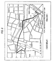
- Figs. 4 and 5 show the case in which a route adapted to the user's sex, age and hobby is set based on the user information registered on the user registration database S3d of the route setting site S3.
- a jewelry store a and a boutique b between a starting point S and a destination G which are specified are picked up from jewelry stores and boutiques which are registered on the advertisement provider database S3c and the shortest route L1 passing through the jewelry store a and the boutique b is set.
- a book store c between the starting point S and the destination G which is specified is picked out from book stores registered on the advertisement provider database 3c as shown in Fig. 5. Furthermore, if the user is young, a registered convenience store d selling magazines is also picked up and the shortest route L2 passing through the book store c and the convenience store d is set.
- Figs. 6 to 8 show the case in which a route is set in the user's consideration of additional conditions together with the user information registered in the user registration database S3d of the route setting site S3 when the user input additional conditions such as a time, a time zone, a date or a weather to set the route.
- Fig. 6 shows an example in which the user inputs PM 0:00 to 1:00 for a time zone in which the route is passed.
- the route setting server S3a decides that the input time zone is taken for a meal, thereby picking up an eating house between the starting point S and the destination G which is specified from eating houses such as a restaurant which are registered on the advertisement provider database S3c.
- the route setting server S3a further decides that the user is elderly based on the age recorded in the user information of the user registration database S3d when picking up the eating house, it picks up a Japanese restaurant e from the eating houses and a route L3 passing therethrough is determined as a set route.
- Figs. 7 and 8 show an example in which a time for utilization, a time zone and a date which are related to the route are input as additional conditions or a weather during the utilization is input.
- the route setting server 3a sets a route based on weather information such as a weather or a climate which is acquired from the route setting site S3 or other systems or sites or weather conditions input by the user on the basis of the input time, time zone and date.
- weather information such as a weather or a climate which is acquired from the route setting site S3 or other systems or sites or weather conditions input by the user on the basis of the input time, time zone and date.
- a route L4 passing through a shopping district to be an advertisement provider having an arcade g, and furthermore, passing through a convenience store h selling an umbrella is set such that the user can walk without getting wet in the rain as shown in Fig. 7.
- a route L5 passing through a large store j such as a department store or a supermarket having entrances and exits j1 and j2 facing different roads which is an advertisement provider such that the user can keep out of the rain or pass through a route with high air conditioning as shown in Fig. 8.
- Such a route L5 passing through the large store j can be set by storing data on the positions of the entrances and exits of the large store to be the advertisement provider in the route database S3b of the route setting site S3, respectively.
- the route setting manner if the store of the advertisement provider picked up during the route setting faces one of sidewalk sides on a large road, one of sidewalks w on both sides of a road R where a picked-up store k is located is set as a route as shown in Fig. 9 through the storage of data on the identification of right and left sidewalks provided on a road, a signal on an intersection and the position of a crosswalk in the route database S3b of the route setting site S3 as described above.
- a store corresponding to the user information or the additional conditions is enlarged, is differently colored or flashed for the display or only main facilities such as a station or an institution and a store corresponding to the user information or the additional conditions are displayed on the map image so that the store can be distinguished from other stores.
Landscapes
- Engineering & Computer Science (AREA)
- Remote Sensing (AREA)
- Radar, Positioning & Navigation (AREA)
- Automation & Control Theory (AREA)
- Physics & Mathematics (AREA)
- General Physics & Mathematics (AREA)
- Social Psychology (AREA)
- General Health & Medical Sciences (AREA)
- Health & Medical Sciences (AREA)
- Navigation (AREA)
- Traffic Control Systems (AREA)
- Instructional Devices (AREA)
- Information Retrieval, Db Structures And Fs Structures Therefor (AREA)
Abstract
Description
Claims (13)
- A man navigation system comprising:map display means for retrieving map data on a required area from a database and displaying a map image based on the retrieved map data;point specifying means for optionally specifying a first point and a second point in the map image displayed by said map display means;condition setting means for setting a condition for route setting;route setting means for setting a route connecting the first point and the second point in the map image specified by said point specifying means based on the condition set by said condition setting means; androute display means for displaying the route set by said route setting means on the map image displayed by said map display means.
- The man navigation system according to claim 1, whereinsaid condition setting means sets a route setting condition based on user information including a user's sex, age, character, hobby and preference.
- The man navigation system according to claim 2, whereinthe user information is previously recorded in a user registration database and said condition setting means sets the route setting condition by reading the user information from the user registration database.
- The man navigation system according to claim 1, whereinsaid condition setting means sets, as the route setting condition, at least one condition such as a time and time zone that the user utilizes the route connecting the first point and the second point, a weather, a season or a climate.
- The man navigation system according to claim 2, whereinsaid route setting means has facility information database storing information about facilities positioned in the map image displayed by said map display means, retrieves the facilities corresponding to the user information from the facility information database, and selects a route including the retrieved facilities as a set route.
- The man navigation system according to claim 4, whereinsaid route setting means has facility information database storing information about facilities positioned in the map image displayed by said map display means, retrieves, from the facility information database, the facilities corresponding to at least one condition such as the time and time zone, the weather, the season or the climate which is set as the route setting condition by said condition setting means, and selects a route including the retrieved facilities as a set route.
- The man navigation system according to claim 5 or 6, whereinthe facility information stored in the facility information database is recorded based on a request of an advertisement provider.
- The man navigation system according to claim 1, whereinsaid route setting means has a route database storing information about a route on the map image displayed by said map display means and sets a route based on the route information retrieved from the route database.
- The man navigation system according to claim 8, whereinthe route information stored in the route database is related to presence of an arcade.
- The man navigation system according to claim 8, whereinthe route information stored in the route database is related to positions of entrances and exits of large facilities.
- The man navigation system according to claim 8, whereinthe route information stored in the route database is related to a position of a sidewalk provided on both sides of a road.
- The man navigation system according to claim 8, whereinthe route information stored in the route database is related to a position of a crosswalk provided on a road.
- The man navigation system according to claim 5 or 6, whereinsaid route display means displays the facilities retrieved from the facility information database to be distinguished from other facilities on the map image displayed by said map display means.
Applications Claiming Priority (2)
| Application Number | Priority Date | Filing Date | Title |
|---|---|---|---|
| JP26522599 | 1999-09-20 | ||
| JP26522599A JP4080649B2 (en) | 1999-09-20 | 1999-09-20 | Human navigation system |
Publications (2)
| Publication Number | Publication Date |
|---|---|
| EP1085484A2 true EP1085484A2 (en) | 2001-03-21 |
| EP1085484A3 EP1085484A3 (en) | 2001-11-07 |
Family
ID=17414274
Family Applications (1)
| Application Number | Title | Priority Date | Filing Date |
|---|---|---|---|
| EP00308027A Withdrawn EP1085484A3 (en) | 1999-09-20 | 2000-09-15 | Route display device for a navigation system |
Country Status (3)
| Country | Link |
|---|---|
| US (1) | US6470267B1 (en) |
| EP (1) | EP1085484A3 (en) |
| JP (1) | JP4080649B2 (en) |
Cited By (11)
| Publication number | Priority date | Publication date | Assignee | Title |
|---|---|---|---|---|
| WO2004005851A1 (en) * | 2002-07-03 | 2004-01-15 | National Institute Of Information And Communications Technology Incorporated Administrative Agency | Self-movement support system, its method, and recording medium |
| EP1283509A3 (en) * | 2001-08-07 | 2004-05-19 | Hitachi, Ltd. | Information transmission system and traveling server and terminal device for use thereof, and information transmitting method |
| EP1357360A3 (en) * | 2002-04-26 | 2004-05-19 | Robert Bosch Gmbh | Method for operating a navigation system and data carrier for a navigation system |
| EP1455321A3 (en) * | 2003-03-07 | 2005-09-07 | NTT DoCoMo, Inc. | Server apparatus, terminal device and information providing system |
| EP1376059A3 (en) * | 2002-06-27 | 2007-05-09 | Navteq North America, LLC | Method of providing location-based advertising with route information |
| WO2008005186A1 (en) | 2006-06-30 | 2008-01-10 | Microsoft Corporation | Methods and architectures for context-sensitive reminders and service facilitation |
| US8538686B2 (en) | 2011-09-09 | 2013-09-17 | Microsoft Corporation | Transport-dependent prediction of destinations |
| US9163952B2 (en) | 2011-04-15 | 2015-10-20 | Microsoft Technology Licensing, Llc | Suggestive mapping |
| US9756571B2 (en) | 2012-02-28 | 2017-09-05 | Microsoft Technology Licensing, Llc | Energy efficient maximization of network connectivity |
| US9846049B2 (en) | 2008-07-09 | 2017-12-19 | Microsoft Technology Licensing, Llc | Route prediction |
| US10030988B2 (en) | 2010-12-17 | 2018-07-24 | Uber Technologies, Inc. | Mobile search based on predicted location |
Families Citing this family (52)
| Publication number | Priority date | Publication date | Assignee | Title |
|---|---|---|---|---|
| US7196659B1 (en) | 1999-05-07 | 2007-03-27 | Garmin Corporation | Combined global positioning system receiver and radio |
| US7330150B1 (en) | 1999-05-07 | 2008-02-12 | Garmin Corporation | Combined global positioning system receiver and radio |
| JP5052718B2 (en) * | 2001-05-11 | 2012-10-17 | 株式会社ゼンリンデータコム | Computer system and information registration method, map server, base information providing server, and programs thereof |
| JP4097913B2 (en) * | 2001-05-18 | 2008-06-11 | 三菱電機株式会社 | Navigation device |
| JP2002352319A (en) * | 2001-05-28 | 2002-12-06 | Casio Comput Co Ltd | Photo printing vending machine and photo printing vending system |
| JP2003016250A (en) * | 2001-06-28 | 2003-01-17 | Pioneer Electronic Corp | Customer search device, system and method |
| JP2003042789A (en) * | 2001-07-31 | 2003-02-13 | Pioneer Electronic Corp | Communication navigation system and server device thereof, recording medium, communication navigation terminal device |
| DE10145299A1 (en) * | 2001-09-14 | 2003-04-03 | Bosch Gmbh Robert | Procedure for the automatic calculation of optimal routes |
| US7142900B1 (en) | 2001-11-01 | 2006-11-28 | Garmin Ltd. | Combined global positioning system receiver and radio |
| US6807464B2 (en) * | 2002-01-02 | 2004-10-19 | International Business Machines Corporation | Systems and methods for distributing information to an operator of a vehicle |
| US7389242B2 (en) | 2002-05-07 | 2008-06-17 | Re3W Worldwide Limited | Interactive processing of real estate transactions |
| JP4020032B2 (en) * | 2002-09-19 | 2007-12-12 | 日産自動車株式会社 | Presentation method of content provision area |
| US6816782B1 (en) * | 2002-10-10 | 2004-11-09 | Garmin Ltd. | Apparatus, systems and methods for navigation data transfer between portable devices |
| US6768450B1 (en) | 2002-11-07 | 2004-07-27 | Garmin Ltd. | System and method for wirelessly linking a GPS device and a portable electronic device |
| KR101168423B1 (en) | 2003-02-05 | 2012-07-25 | 가부시키가이샤 자나비 인포메틱스 | Path search method of navigation apparatus and display method of traffic information |
| US7590310B2 (en) | 2004-05-05 | 2009-09-15 | Facet Technology Corp. | Methods and apparatus for automated true object-based image analysis and retrieval |
| US20050273346A1 (en) * | 2004-06-02 | 2005-12-08 | Frost Richard N | Real property information management system and method |
| US7421341B1 (en) * | 2004-06-30 | 2008-09-02 | Navteq North America, Llc | Method of collecting information for a geographic database for use with a navigation system |
| US7149626B1 (en) * | 2004-06-30 | 2006-12-12 | Navteq North America, Llc | Method of operating a navigation system |
| JP3697454B1 (en) * | 2005-01-14 | 2005-09-21 | インコムジャパン有限会社 | Route guidance system according to individual body characteristics |
| US7451041B2 (en) * | 2005-05-06 | 2008-11-11 | Facet Technology Corporation | Network-based navigation system having virtual drive-thru advertisements integrated with actual imagery from along a physical route |
| US7925320B2 (en) | 2006-03-06 | 2011-04-12 | Garmin Switzerland Gmbh | Electronic device mount |
| JP4680131B2 (en) * | 2006-05-29 | 2011-05-11 | トヨタ自動車株式会社 | Own vehicle position measuring device |
| US7610151B2 (en) * | 2006-06-27 | 2009-10-27 | Microsoft Corporation | Collaborative route planning for generating personalized and context-sensitive routing recommendations |
| US20080097688A1 (en) * | 2006-06-27 | 2008-04-24 | Microsoft Corporation | Route generation based upon activity criteria |
| US8793066B2 (en) * | 2006-06-27 | 2014-07-29 | Microsoft Corporation | Route monetization |
| WO2008004355A1 (en) | 2006-07-06 | 2008-01-10 | Joytec Corporation | Ice shaving machine |
| JP2008122256A (en) * | 2006-11-13 | 2008-05-29 | Navitime Japan Co Ltd | Navigation system, route search server, and route search method |
| DE102006057598A1 (en) * | 2006-12-06 | 2008-06-12 | Siemens Ag | Method and device for operating a navigation device |
| JP4879847B2 (en) * | 2007-09-03 | 2012-02-22 | 株式会社野村総合研究所 | Route guidance system and method |
| US20090157499A1 (en) * | 2007-12-14 | 2009-06-18 | Microsoft Corporation | Automatic splices for targeted advertisements |
| US8473198B2 (en) * | 2007-12-14 | 2013-06-25 | Microsoft Corporation | Additional content based on intended travel destination |
| US8428859B2 (en) * | 2007-12-14 | 2013-04-23 | Microsoft Corporation | Federated route production |
| US8060297B2 (en) * | 2007-12-14 | 2011-11-15 | Microsoft Corporation | Route transfer between devices |
| US20090157498A1 (en) * | 2007-12-14 | 2009-06-18 | Microsoft Corporation | Generational intelligent navigation synchronization or update |
| US20090157540A1 (en) * | 2007-12-14 | 2009-06-18 | Microsoft Corporation | Destination auctioned through business of interest |
| US20090157312A1 (en) * | 2007-12-14 | 2009-06-18 | Microsoft Corporation | Social network based routes |
| US8090532B2 (en) * | 2007-12-14 | 2012-01-03 | Microsoft Corporation | Pedestrian route production |
| US20090210142A1 (en) * | 2008-02-19 | 2009-08-20 | Microsoft Corporation | Safe route configuration |
| US20090210276A1 (en) * | 2008-02-19 | 2009-08-20 | Microsoft Corporation | Ad hoc and opportunistic transportation services |
| US8793065B2 (en) * | 2008-02-19 | 2014-07-29 | Microsoft Corporation | Route-based activity planner |
| US20090210242A1 (en) * | 2008-02-19 | 2009-08-20 | Microsoft Corporation | Load balance payment |
| US10314533B2 (en) | 2009-08-28 | 2019-06-11 | Samsung Electronics Co., Ltd | Method and apparatus for recommending a route |
| KR101681312B1 (en) | 2009-08-28 | 2016-12-02 | 삼성전자 주식회사 | Method and apparatus for recommending of course |
| DE102009060365A1 (en) * | 2009-12-24 | 2012-03-01 | Volkswagen Ag | Navigation system, in particular for a motor vehicle |
| US8494770B2 (en) * | 2011-03-15 | 2013-07-23 | Qualcomm Incorporated | Method and system for generating savings routes with a portable computing device |
| JP5143969B2 (en) * | 2012-05-28 | 2013-02-13 | 株式会社ゼンリンデータコム | Map display method and computer system, map server, base information providing server, and programs thereof |
| US9677886B2 (en) * | 2013-02-10 | 2017-06-13 | Qualcomm Incorporated | Method and apparatus for navigation based on media density along possible routes |
| JP2017026537A (en) * | 2015-07-27 | 2017-02-02 | 清水建設株式会社 | Navigation system and route selection method for navigation system |
| CN108845289B (en) | 2018-07-03 | 2021-08-03 | 京东方科技集团股份有限公司 | A method and system for locating a shopping cart in a supermarket, and a shopping cart in a supermarket |
| JP2020063940A (en) | 2018-10-16 | 2020-04-23 | トヨタ自動車株式会社 | Mobile |
| CN114413923B (en) * | 2022-01-25 | 2024-03-15 | 中国第一汽车股份有限公司 | Driving route recommendation method, device, storage medium and system |
Family Cites Families (13)
| Publication number | Priority date | Publication date | Assignee | Title |
|---|---|---|---|---|
| DE715289C (en) | 1935-01-05 | 1941-12-18 | Sperry Gyroscope Co Inc | Gyro magnetic compass |
| US5031104A (en) * | 1988-12-05 | 1991-07-09 | Sumitomo Electric Industries, Ltd. | Adaptive in-vehicle route guidance system |
| US5802492A (en) * | 1994-06-24 | 1998-09-01 | Delorme Publishing Company, Inc. | Computer aided routing and positioning system |
| JP3632706B2 (en) * | 1994-09-22 | 2005-03-23 | アイシン・エィ・ダブリュ株式会社 | Vehicle navigation device |
| ES2179087T3 (en) * | 1994-11-28 | 2003-01-16 | Vodafone Ag | PROCEDURE AND SYSTEM TO GUIDE A VEHICLE TO A DESTINATION. |
| JPH09114367A (en) * | 1995-10-24 | 1997-05-02 | Mitsubishi Electric Corp | In-vehicle drive controller |
| KR100235240B1 (en) * | 1995-10-31 | 1999-12-15 | 모리 하루오 | Navigation apparatus |
| JPH109884A (en) * | 1996-06-24 | 1998-01-16 | Mitsubishi Electric Corp | Vehicle route guidance device and route search method |
| JP3446930B2 (en) * | 1996-09-30 | 2003-09-16 | 松下電器産業株式会社 | Route selection method and route selection device |
| KR100288284B1 (en) * | 1996-09-30 | 2001-05-02 | 모리 하루오 | Car Navigation |
| US6047280A (en) * | 1996-10-25 | 2000-04-04 | Navigation Technologies Corporation | Interface layer for navigation system |
| US5944769A (en) * | 1996-11-08 | 1999-08-31 | Zip2 Corporation | Interactive network directory service with integrated maps and directions |
| JPH1138872A (en) * | 1997-07-17 | 1999-02-12 | Toyota Motor Corp | Map data distribution system and map data acquisition device suitable for the system |
-
1999
- 1999-09-20 JP JP26522599A patent/JP4080649B2/en not_active Expired - Fee Related
-
2000
- 2000-09-15 EP EP00308027A patent/EP1085484A3/en not_active Withdrawn
- 2000-09-20 US US09/665,129 patent/US6470267B1/en not_active Expired - Lifetime
Cited By (16)
| Publication number | Priority date | Publication date | Assignee | Title |
|---|---|---|---|---|
| EP1283509A3 (en) * | 2001-08-07 | 2004-05-19 | Hitachi, Ltd. | Information transmission system and traveling server and terminal device for use thereof, and information transmitting method |
| EP1357360A3 (en) * | 2002-04-26 | 2004-05-19 | Robert Bosch Gmbh | Method for operating a navigation system and data carrier for a navigation system |
| EP1376059A3 (en) * | 2002-06-27 | 2007-05-09 | Navteq North America, LLC | Method of providing location-based advertising with route information |
| WO2004005851A1 (en) * | 2002-07-03 | 2004-01-15 | National Institute Of Information And Communications Technology Incorporated Administrative Agency | Self-movement support system, its method, and recording medium |
| EP1455321A3 (en) * | 2003-03-07 | 2005-09-07 | NTT DoCoMo, Inc. | Server apparatus, terminal device and information providing system |
| US7209827B2 (en) | 2003-03-07 | 2007-04-24 | Ntt Docomo, Inc. | Server apparatus, terminal device, and information providing system |
| WO2008005186A1 (en) | 2006-06-30 | 2008-01-10 | Microsoft Corporation | Methods and architectures for context-sensitive reminders and service facilitation |
| EP2038762A4 (en) * | 2006-06-30 | 2011-11-09 | Microsoft Corp | Methods and architectures for context-sensitive reminders and service facilitation |
| US9846049B2 (en) | 2008-07-09 | 2017-12-19 | Microsoft Technology Licensing, Llc | Route prediction |
| US10030988B2 (en) | 2010-12-17 | 2018-07-24 | Uber Technologies, Inc. | Mobile search based on predicted location |
| US10935389B2 (en) | 2010-12-17 | 2021-03-02 | Uber Technologies, Inc. | Mobile search based on predicted location |
| US11614336B2 (en) | 2010-12-17 | 2023-03-28 | Uber Technologies, Inc. | Mobile search based on predicted location |
| US12078501B2 (en) | 2010-12-17 | 2024-09-03 | Uber Technologies, Inc. | Mobile search based on predicted location |
| US9163952B2 (en) | 2011-04-15 | 2015-10-20 | Microsoft Technology Licensing, Llc | Suggestive mapping |
| US8538686B2 (en) | 2011-09-09 | 2013-09-17 | Microsoft Corporation | Transport-dependent prediction of destinations |
| US9756571B2 (en) | 2012-02-28 | 2017-09-05 | Microsoft Technology Licensing, Llc | Energy efficient maximization of network connectivity |
Also Published As
| Publication number | Publication date |
|---|---|
| JP2001091292A (en) | 2001-04-06 |
| JP4080649B2 (en) | 2008-04-23 |
| US6470267B1 (en) | 2002-10-22 |
| EP1085484A3 (en) | 2001-11-07 |
Similar Documents
| Publication | Publication Date | Title |
|---|---|---|
| US6470267B1 (en) | Man navigation system | |
| US8972186B2 (en) | Electronic guide system, contents server for electronic guide system, portable electronic guide device, and information processing method for electronic guide system | |
| US7599795B1 (en) | Mobile location aware search engine and method of providing content for same | |
| US5948040A (en) | Travel reservation information and planning system | |
| US7827507B2 (en) | System to navigate within images spatially referenced to a computed space | |
| WO1998035311A9 (en) | Travel reservation and information planning system | |
| US20010013013A1 (en) | Advertisement display system in map-information providing service | |
| US20040093157A1 (en) | Method for linking geographical and commercial data and providing the same | |
| JP4165269B2 (en) | Reliability information display system | |
| JP2002116033A (en) | Device and method for landmark guidance, information storage medium, and device and method for landmark registration | |
| JP3519342B2 (en) | Map information providing system and providing method | |
| JP6929431B1 (en) | Information processing equipment, information processing methods and information processing programs | |
| Steiniger et al. | Foundations of LBS | |
| JP2004294257A (en) | Navigation system, program therefor and record medium | |
| US20040117112A1 (en) | Point service utilizing system, method of utilizing point service, and navigation apparatus | |
| JP7012781B2 (en) | Information processing equipment, information processing methods and information processing programs | |
| JP2020166525A (en) | Information providing device, information providing program, and information providing method | |
| JP2002026804A (en) | Specific facility information providing system, specific facility information providing method, and portable information terminal | |
| JPH09159481A (en) | Map display device, navigation apparatus and medium with stored computer program for processing of map information | |
| JP3651784B2 (en) | Navigation device | |
| JP4610838B2 (en) | Information processing system | |
| JP3508132B2 (en) | Navigation device and navigation method | |
| JP3849454B2 (en) | Navigation device and navigation method | |
| JP3632899B2 (en) | Navigation device and navigation method | |
| JP2006343939A (en) | Peripheral condition property retrieval system, peripheral condition property retrieval server, and terminal device |
Legal Events
| Date | Code | Title | Description |
|---|---|---|---|
| PUAI | Public reference made under article 153(3) epc to a published international application that has entered the european phase |
Free format text: ORIGINAL CODE: 0009012 |
|
| AK | Designated contracting states |
Kind code of ref document: A2 Designated state(s): AT BE CH CY DE DK ES FI FR GB GR IE IT LI LU MC NL PT SE Kind code of ref document: A2 Designated state(s): DE FR GB |
|
| AX | Request for extension of the european patent |
Free format text: AL;LT;LV;MK;RO;SI |
|
| PUAL | Search report despatched |
Free format text: ORIGINAL CODE: 0009013 |
|
| AK | Designated contracting states |
Kind code of ref document: A3 Designated state(s): AT BE CH CY DE DK ES FI FR GB GR IE IT LI LU MC NL PT SE |
|
| AX | Request for extension of the european patent |
Free format text: AL;LT;LV;MK;RO;SI |
|
| RIC1 | Information provided on ipc code assigned before grant |
Free format text: 7G 08G 1/0969 A, 7G 01C 21/36 B, 7G 01C 21/34 B |
|
| 17P | Request for examination filed |
Effective date: 20020417 |
|
| AKX | Designation fees paid |
Free format text: DE FR GB |
|
| 17Q | First examination report despatched |
Effective date: 20070706 |
|
| STAA | Information on the status of an ep patent application or granted ep patent |
Free format text: STATUS: THE APPLICATION IS DEEMED TO BE WITHDRAWN |
|
| 18D | Application deemed to be withdrawn |
Effective date: 20071117 |