EP0911652B1 - Verfahren zur Angleichung von seismischen Daten und Bohrlochdaten in einer 3D Modellierung der Erde - Google Patents
Verfahren zur Angleichung von seismischen Daten und Bohrlochdaten in einer 3D Modellierung der Erde Download PDFInfo
- Publication number
- EP0911652B1 EP0911652B1 EP98308059A EP98308059A EP0911652B1 EP 0911652 B1 EP0911652 B1 EP 0911652B1 EP 98308059 A EP98308059 A EP 98308059A EP 98308059 A EP98308059 A EP 98308059A EP 0911652 B1 EP0911652 B1 EP 0911652B1
- Authority
- EP
- European Patent Office
- Prior art keywords
- cell
- rock property
- cells
- simulated
- vertical
- Prior art date
- Legal status (The legal status is an assumption and is not a legal conclusion. Google has not performed a legal analysis and makes no representation as to the accuracy of the status listed.)
- Expired - Lifetime
Links
- 238000000034 method Methods 0.000 title claims description 33
- 239000011435 rock Substances 0.000 claims description 36
- 238000005259 measurement Methods 0.000 claims description 13
- 238000005070 sampling Methods 0.000 claims description 6
- 238000007476 Maximum Likelihood Methods 0.000 claims description 4
- 238000013507 mapping Methods 0.000 claims 1
- 238000004088 simulation Methods 0.000 description 10
- 230000000875 corresponding effect Effects 0.000 description 6
- 230000008569 process Effects 0.000 description 6
- 230000008901 benefit Effects 0.000 description 4
- 238000012935 Averaging Methods 0.000 description 3
- 238000012545 processing Methods 0.000 description 3
- 238000002922 simulated annealing Methods 0.000 description 3
- 238000004458 analytical method Methods 0.000 description 2
- 230000015572 biosynthetic process Effects 0.000 description 2
- 238000004364 calculation method Methods 0.000 description 2
- 230000003750 conditioning effect Effects 0.000 description 2
- 238000010586 diagram Methods 0.000 description 2
- 238000005755 formation reaction Methods 0.000 description 2
- 230000010354 integration Effects 0.000 description 2
- 239000004215 Carbon black (E152) Substances 0.000 description 1
- 230000002411 adverse Effects 0.000 description 1
- 238000012512 characterization method Methods 0.000 description 1
- 230000001276 controlling effect Effects 0.000 description 1
- 230000002596 correlated effect Effects 0.000 description 1
- 238000005516 engineering process Methods 0.000 description 1
- 238000001914 filtration Methods 0.000 description 1
- 239000012530 fluid Substances 0.000 description 1
- 230000014509 gene expression Effects 0.000 description 1
- 229930195733 hydrocarbon Natural products 0.000 description 1
- 150000002430 hydrocarbons Chemical class 0.000 description 1
- 230000033001 locomotion Effects 0.000 description 1
- 230000004048 modification Effects 0.000 description 1
- 238000012986 modification Methods 0.000 description 1
- 230000008520 organization Effects 0.000 description 1
- 230000000704 physical effect Effects 0.000 description 1
- 230000000644 propagated effect Effects 0.000 description 1
- 238000012887 quadratic function Methods 0.000 description 1
- 238000012552 review Methods 0.000 description 1
- 230000008054 signal transmission Effects 0.000 description 1
- 238000007619 statistical method Methods 0.000 description 1
- 238000002948 stochastic simulation Methods 0.000 description 1
- 230000009466 transformation Effects 0.000 description 1
Images
Classifications
-
- G—PHYSICS
- G01—MEASURING; TESTING
- G01V—GEOPHYSICS; GRAVITATIONAL MEASUREMENTS; DETECTING MASSES OR OBJECTS; TAGS
- G01V11/00—Prospecting or detecting by methods combining techniques covered by two or more of main groups G01V1/00 - G01V9/00
Definitions
- a sound source at or near the surface of the earth, is caused periodically to inject an acoustic wavefield into the earth at each of a plurality of regularly-spaced survey stations.
- the wavefield radiates in all directions to insonify the subsurface earth formations whence it is reflected back to be received by seismic sensors (receivers) located at designated stations at or near the surface of the earth.
- the seismic sensors convert the mechanical earth motions, due to the reflected wavefield, to electrical signals.
- the resulting electrical signals are transmitted over a signal-transmission link of any desired type, to instrumentation, usually digital, where the seismic data signals are archivally stored for later analytic processing.
- the travel-time lapse between the emission of a wavefield by a source and the reception of the resulting sequence of reflected wavefields by a receiver is a measure of the depths of the respective earth formations from which the wavefield was reflected.
- Certain attributes of the signals such as signal amplitude level and frequency may be related to the type of rock through which the wavefield propagated or from which the wavefield was reflected.
- the seismic survey stations of a 3-D survey are preferably distributed in a regular grid over an area of interest with inter-station spacings on the order of 25 meters.
- the processed seismic data associated with a plurality of seismic traces from a plurality of receivers distributed over an area under survey may be formatted by well-known analytic methods to create a model of a volume of the earth.
- the model may be structural, showing the physical attitudes of the respective earth strata of an entire geologic sequence such as depth, dip and strike.
- the model may be designed to exhibit variations in the level of a selected seismic attribute, such as seismic impedance. Seismic impedance may be statistically related to variations in the texture of some physical property of subsurface rocks such as porosity or lithology.
- the purpose of such earth models is to select optimal locations for boreholes drilled to recover some desired natural resource such as fluid hydrocarbon products.
- a detailed picture of the stratigraphy of the vertical geologic column at a wellsite can be provided by one or more logging tools of any one of many different known types, that may be lowered into a borehole on a wireline, on the drill stem in MWD operations or on coiled tubing.
- the vertical measurement resolution of wireline tools is very good; it may be on the order of centimeters or often, even millimeters.
- boreholes are far apart, particularly in newly-developed prospects; the well spacing may be hundreds or more meters. For that reason, the horizontal resolution of log data measurements is very poor.
- the seismic stations are closely-spaced horizontally, perhaps on the order of 25 meters or less, thus providing excellent lateral resolution.
- the vertical, time-scale resolution of seismic data is a function of the frequency of the reflected seismic energy and the wavefield propagation velocity.
- the vertical resolution of typical low-frequency reflected seismic signals, after processing, may be on the order of tens of meters.
- seismic attributes are typically correlated with petrophysical well data averaged vertically across earth strata which may be several tens of meters thick. The seismic attributes are then used to guide the areal interpolation of the well-derived zone average data.
- the techniques of kriging and cokriging are commonly-used geostatistical methods for performing this interpolation task.
- Kriging is a spatial prediction method for generating the best linear unbiased estimate of a rock property value by statistical interpolation of well data.
- Cokriging is a spatial prediction method using seismic attributes as secondary data to guide the interpolation of the average rock characteristic measured in wells. Both methods are analogous to Wiener filtering techniques applied in the time domain.
- the cokriging method is useful to derive an areal model of an average rock property for a given earth stratum by combining well and seismic data.
- this and other similar techniques do not provide a vertically detailed 3-D model of the subsurface layer.
- Three-dimensional modeling requires careful integration of log and seismic data at different scales. A review of prior integration efforts follows.
- This disclosure teaches a stochastic interpolation method which may be used to generate a vertically detailed 3-D earth model of a rock characteristic by combining finely-sampled log data with seismic attributes representing vertical average of the rock property of interest.
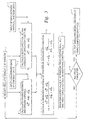
- a computer-aided geostatistical method for simulating, from seismic data, the spatial distribution of a designated rock property over a three-dimensional (3-D) array of cells The array represents a discretized model of a subsurface earth layer wherein the vertical cell thickness is substantially less than the vertical resolution of the seismic data.
- a first set of log derived measurements of the designated rock property, made at control cells along well trajectories, is assembled in a programmed computer.
- a second set of measurements is assembled in said programmed computer corresponding to seismically-derived, vertical average values of the same rock property at each vertical column of the cells in the model.
- a cell to be simulated is randomly selected from the 3-D array.
- a search region is defined, centered around the cell to be simulated.
- the kriging estimate and variance of the rock property is calculated at the chosen cell from the rock property values at control cells located within the search region.
- the most likely rock property value is determined at the cell based on the measured vertical average for the column containing the cell and the rock property values at control cells in the same column.
- the variance of the Gaussian likelihood function is calculated at the cell under consideration. Thereafter, the mean of the Gaussian posterior probability distribution is determined for that cell as a weighted linear combination of the previously-derived kriging and maximum likelihood estimates.
- the variance of the posterior distribution is now calculated from the kriging variance and the variance of the likelihood function.
- a simulated rock property is generated at the cell by sampling at random from the posterior probability distribution.
- the simulated rock property is entered into the array as an additional control cell. The entire process is repeated until all cells in the array have been simulated. Thereupon, with the aid of a computer graphics program, the distribution of the simulated rock property is mapped over the 3-D array cells.
- a discretized earth model is defined as a 3-D array of cells. Each cell is indexed by an integer, i. The vertical thickness of each cell is assumed to be much smaller than the vertical resolution of surface seismic data. Please refer now to Figure 1 which represents a vertical section through the discretized earth model, generally shown as 10.
- a rock property variable x i is defined in each cell, representing for example, porosity.
- the cells in the earth model are assumed to have quasi point support, meaning that the co-variances in (2) are point-to-point values as taught by to US patent 5,416,750, issued May 16, 1995 to P.M. Doyen et al., and which is incorporated herein by reference.
- x 0 represent the rock property value to be simulated at current cell 0.
- z represent the seismic-derived vertical average rock property of the column of cells, 12, containing cell 0.
- the coefficients a j represent user-specified averaging weights which may vary vertically from cell to cell as shown by graph 14 to the left side of Figure 1.
- a simulated value for x 0 is obtained by sampling at random from the local posterior distribution p(x 0
- set s is equal to ⁇ 1,2,3,4,5 ⁇ . Sequential sampling of the conditional distribution (4) at all cells generates a simulated earth model constrained by the well data and the vertical averages.
- the first term in (5) is a Gaussian distribution given by with mean x 0 SK equal to the simple kriging estimate of x 0 and variance ⁇ 2 SK equal to the corresponding kriging estimation variance, the kriging being performed using x, as conditioning data.
- the variable z was defined as the weighted sum of the variables in one column of the earth model. Ignoring the vertical correlation between the variables x in a column, it can be shown that the likelihood function 1 (x 0 ) is also a Gaussian kernel with mean given by and variance given by In (7), x 0 ML may be interpreted as the Maximum Likelihood estimate of x 0 based on the measured vertical column average z and the weighted sum of all previously simulated values in the column x j , j ⁇ c. In (8), the summation is over all cells not yet simulated in the column containing cell 0.
- the mean of the posterior distribution in (9) is a linear combination of point kriging estimate x 0 SK of the cell value and the maximum likelihood estimate x 0 ML based on the vertical column average and the previously simulated cell values in the column.
- the simulated earth models approximately reproduce the vertical column averages with a tolerance depending upon the value of the noise variance ⁇ ⁇ 2 .
- the vertical column average data are reproduced exactly when the noise variance is zero.
- exact reproduction of seismic-derived column averages is not desirable and may give rise to abrupt changes in simulated values.
- a laterally variable tolerance level may even be specified to reflect changes in the accuracy of the seismic average information.
Landscapes
- Physics & Mathematics (AREA)
- Life Sciences & Earth Sciences (AREA)
- General Life Sciences & Earth Sciences (AREA)
- General Physics & Mathematics (AREA)
- Geophysics (AREA)
- Geophysics And Detection Of Objects (AREA)
Claims (2)
- Computerunterstütztes geostatistisches Verfahren zum Simulieren der räumlichen Verteilung einer bestimmten kontinuierlichen Felseigenschaft über ein dreidimensionales Zellenfeld aus seismischen Daten, wobei das Feld ein diskretisiertes Modell einer Erdschicht unter der Oberfläche darstellt und die vertikale Dicke der Zellen geringer ist als die vertikale Auflösung der seismischen Daten, aufweisend:a) Sammeln eines ersten Satzes an durch ein Log erhaltene Messungen der bestimmten Felseigenschaft, die bei Kontrollzellen entlang von Brunnentrajektorien ausgeführt wurden, und eines zweiten Satzes an Messungen entsprechend seismisch erhaltenen, vertikalen Durchschnittswerten derselben Felseigenschaft bei jeder vertikalen Zellenspalte in einem programmierten Computer, der einen Datenprozessor umfasst;b) zufälliges Auswählen einer zu simulierenden Zelle aus dem dreidimensionalen Feld und Definieren eines Suchbereiches um die Zelle herum;c) Errechnen der Kriging-Abschätzung und der Kriging-Varianz des Wertes der Felseigenschaft bei der Zelle aus den Felseigenschaftswerten bei Kontrollzellen, die sich innerhalb des Suchbereichs befinden;d) Bestimmen des wahrscheinlichsten Wertes der Felseigenschaft bei dieser Zelle basierend auf dem gemessenen vertikalen Durchschnitt für die Spalte, welche die Zelle enthält, und den Werten der Felseigenschaft bei Kontrollzellen in der selben Spalte;e) Errechnen der Varianz der Gaußschen Wahrscheinlichkeitsfunktion bei der Zelle;f) Errechnen des Mittelwertes der Gaußschen hinteren Wahrscheinlichkeitsverteilung bei der Zelle als gewichtete Linearkombination der Kriging-Abschätzung und des wahrscheinlichsten Schätzwertes, der in den Schritten c) bzw. d) ermittelt wurde;g) Errechnen der Varianz der hinteren Wahrscheinlichkeitsverteilung aus der Kriging-Varianz und der Varianz der Wahrscheinlichkeitsfunktion, die in den Schritten c) bzw.e) hergeleitet wurde;h) Erzeugen eines Wertes der simulierten Felseigenschaft bei der Zelle durch zufälliges Abfragen aus der hinteren Wahrscheinlichkeitsverteilung;i) Eingeben des Wertes der simulierten Felseigenschaft in das Feld, um eine zusätzliche Kontrollzelle zu erzeugen;j) Wiederholen der Schritte b) bis i), bis alle Zellen im Feld simuliert worden sind; undk) Abbilden der Verteilung der Werte der simulierten Felseigenschaft mit der Hilfe eines Computergrafikprogrammes über dem dreidimensionalen Feld von Zellen, um eine konkrete globale Darstellung der Felseigenschaftverteilung anzugeben.
- Anzeigesystem, aufweisend:Mittel zum Empfangen von eingegebenen aus einem Log erhaltenen Messungen einer Felseigenschaft und eines Satzes an Messungen entsprechend seismisch hergeleiteten, vertikalen Durchschnittswerten derselben Felseigenschaft;Mittel zum Simulieren der räumlichen Verteilung der Eigenschaft unter Verwendung des Verfahrens nach Anspruch 1; undMittel zum Darstellen der Eigenschaftsveneilung.
Applications Claiming Priority (2)
| Application Number | Priority Date | Filing Date | Title |
|---|---|---|---|
| US08/943,577 US5995906A (en) | 1997-10-03 | 1997-10-03 | Method for reconciling data at seismic and well-log scales in 3-D earth modeling |
| US943577 | 1997-10-03 |
Publications (3)
| Publication Number | Publication Date |
|---|---|
| EP0911652A2 EP0911652A2 (de) | 1999-04-28 |
| EP0911652A3 EP0911652A3 (de) | 2000-08-30 |
| EP0911652B1 true EP0911652B1 (de) | 2004-12-15 |
Family
ID=25479888
Family Applications (1)
| Application Number | Title | Priority Date | Filing Date |
|---|---|---|---|
| EP98308059A Expired - Lifetime EP0911652B1 (de) | 1997-10-03 | 1998-10-02 | Verfahren zur Angleichung von seismischen Daten und Bohrlochdaten in einer 3D Modellierung der Erde |
Country Status (3)
| Country | Link |
|---|---|
| US (1) | US5995906A (de) |
| EP (1) | EP0911652B1 (de) |
| NO (1) | NO327326B1 (de) |
Families Citing this family (35)
| Publication number | Priority date | Publication date | Assignee | Title |
|---|---|---|---|---|
| US6185512B1 (en) | 1998-10-13 | 2001-02-06 | Raytheon Company | Method and system for enhancing the accuracy of measurements of a physical quantity |
| US6721694B1 (en) | 1998-10-13 | 2004-04-13 | Raytheon Company | Method and system for representing the depths of the floors of the oceans |
| FR2792419B1 (fr) * | 1999-04-16 | 2001-09-07 | Inst Francais Du Petrole | Methode pour obtenir un modele optimal d'une caracteristique physique dans un milieu heterogene, tel que le sous-sol |
| FR2795841B1 (fr) * | 1999-07-02 | 2001-08-10 | Inst Francais Du Petrole | Methode pour deformer graduellement des simulations sequentielles d'un milieu heterogene tel qu'une zone souterraine |
| US7415401B2 (en) * | 2000-08-31 | 2008-08-19 | Exxonmobil Upstream Research Company | Method for constructing 3-D geologic models by combining multiple frequency passbands |
| US6792354B1 (en) | 2000-11-13 | 2004-09-14 | O'meara, Jr. Daniel J. | Method for determining reservoir fluid volumes, fluid contacts, compartmentalization, and permeability in geological subsurface models |
| US7054749B1 (en) | 2000-11-13 | 2006-05-30 | O'meara Jr Daniel J | Method for determining reservoir fluid volumes, fluid contacts, compartmentalization, and permeability in geological subsurface models |
| US6597992B2 (en) | 2001-11-01 | 2003-07-22 | Soil And Topography Information, Llc | Soil and topography surveying |
| FR2834797B1 (fr) * | 2002-01-14 | 2004-10-08 | Geophysique Cie Gle | Procede de filtrage de donnees, notamment de types sismiques, par analyse krigeante |
| US7072768B1 (en) | 2003-05-02 | 2006-07-04 | Young Alan G | Method for laterally extrapolating soil property data using soil samples and seismic amplitude data within a seismic coverage area |
| US7933757B2 (en) * | 2004-03-31 | 2011-04-26 | Exxonmobil Upstream Research Co. | Method for simulating and estimating sandstone properties |
| US7953587B2 (en) * | 2006-06-15 | 2011-05-31 | Schlumberger Technology Corp | Method for designing and optimizing drilling and completion operations in hydrocarbon reservoirs |
| RU2475784C2 (ru) | 2007-12-19 | 2013-02-20 | Эксонмобил Апстрим Рисерч Компани | Моделирование характеристики гамма-лучевого каротажного зонда |
| AU2009244726B2 (en) * | 2008-05-05 | 2014-04-24 | Exxonmobil Upstream Research Company | Modeling dynamic systems by visualizing and narrowing a parameter space |
| US8861306B2 (en) * | 2008-07-05 | 2014-10-14 | Westerngeco L.L.C. | Interpolating seismic data |
| GB2463242B (en) * | 2008-09-03 | 2012-11-07 | Statoilhydro Asa | Method of modelling a subterranean region of the earth |
| CA2743479C (en) | 2008-11-14 | 2016-06-28 | Exxonmobil Upstream Research Company | Forming a model of a subsurface region |
| CN102257377B (zh) | 2008-12-18 | 2014-09-10 | 埃克森美孚上游研究公司 | 浊流的重叠多层深度平均流动模型 |
| WO2010104537A1 (en) | 2009-03-11 | 2010-09-16 | Exxonmobil Upstream Research Company | Adjoint-based conditioning of process-based geologic models |
| US8612195B2 (en) | 2009-03-11 | 2013-12-17 | Exxonmobil Upstream Research Company | Gradient-based workflows for conditioning of process-based geologic models |
| US9128212B2 (en) | 2009-04-20 | 2015-09-08 | Exxonmobil Upstream Research Company | Method for predicting fluid flow |
| BR112012009154A2 (pt) | 2009-10-23 | 2016-08-16 | Exxonmobil Upstream Res Co | método para melhorar um modelo geológico de uma região de subsuperfície, produto de programa de computador, e, método para controlar hidrocarbonetos em uma região de subsuperfície |
| US8775142B2 (en) * | 2010-05-14 | 2014-07-08 | Conocophillips Company | Stochastic downscaling algorithm and applications to geological model downscaling |
| EA025127B1 (ru) * | 2010-06-18 | 2016-11-30 | Лэндмарк Грэфикс Корпорейшн | Способ вычисления вариограммной модели скважины и постоянное устройство для вычисления посредством программы вариограммной модели скважины |
| FR2972539B1 (fr) | 2011-03-09 | 2013-04-26 | Total Sa | Procede informatique d'estimation, procede d'exploration et d'exploitation petroliere mettant en oeuvre un tel procede |
| WO2014051904A1 (en) | 2012-09-26 | 2014-04-03 | Exxonmobil Upstream Research Company | Conditional process-aided multiple-points statistics modeling |
| US10228987B2 (en) | 2013-02-28 | 2019-03-12 | Baker Hughes, A Ge Company, Llc | Method to assess uncertainties and correlations resulting from multi-station analysis of survey data |
| US9746567B2 (en) * | 2013-03-22 | 2017-08-29 | Cgg Services Sas | Systems and methods for performing dual-scale interpolation |
| CN104316961B (zh) * | 2014-11-04 | 2017-04-19 | 中国石油集团川庆钻探工程有限公司地球物理勘探公司 | 获取风化层的地质参数的方法 |
| US10822922B2 (en) | 2015-01-19 | 2020-11-03 | International Business Machines Corporation | Resource identification using historic well data |
| EP3171203B1 (de) * | 2015-11-18 | 2019-01-02 | CGG Services SAS | Adaptive anordnungsbasiertes verfahren und vorrichtung für stark nichtlineare probleme |
| CN106484997B (zh) * | 2016-10-10 | 2021-12-14 | 南京林业大学 | 一种基于克里金插值的水岸带淤泥厚度计算及出图方法 |
| CN107728209B (zh) * | 2017-10-13 | 2019-11-05 | 中国地质大学(北京) | 一种确定人工地震记录垂向分辨率的方法 |
| US11248448B2 (en) * | 2020-02-03 | 2022-02-15 | Saudi Arabian Oil Company | Despiking reservoir properties |
| US11693150B2 (en) | 2020-10-08 | 2023-07-04 | Saudi Arabian Oil Company | Coordinate-related despiking of hydrocarbon reservoir data |
Family Cites Families (4)
| Publication number | Priority date | Publication date | Assignee | Title |
|---|---|---|---|---|
| US5321613A (en) * | 1992-11-12 | 1994-06-14 | Coleman Research Corporation | Data fusion workstation |
| FR2710418B1 (fr) * | 1993-09-21 | 1995-12-15 | Inst Francais Du Petrole | Méthode d'analyse des traces sismiques utilisant une technique de calibrage statistique pour en déduire des propriétés géologiques. |
| US5416750A (en) * | 1994-03-25 | 1995-05-16 | Western Atlas International, Inc. | Bayesian sequential indicator simulation of lithology from seismic data |
| US5838634A (en) * | 1996-04-04 | 1998-11-17 | Exxon Production Research Company | Method of generating 3-D geologic models incorporating geologic and geophysical constraints |
-
1997
- 1997-10-03 US US08/943,577 patent/US5995906A/en not_active Expired - Fee Related
-
1998
- 1998-09-28 NO NO19984499A patent/NO327326B1/no not_active IP Right Cessation
- 1998-10-02 EP EP98308059A patent/EP0911652B1/de not_active Expired - Lifetime
Also Published As
| Publication number | Publication date |
|---|---|
| NO984499D0 (no) | 1998-09-28 |
| US5995906A (en) | 1999-11-30 |
| EP0911652A2 (de) | 1999-04-28 |
| NO984499L (no) | 1999-04-06 |
| NO327326B1 (no) | 2009-06-08 |
| EP0911652A3 (de) | 2000-08-30 |
Similar Documents
| Publication | Publication Date | Title |
|---|---|---|
| EP0911652B1 (de) | Verfahren zur Angleichung von seismischen Daten und Bohrlochdaten in einer 3D Modellierung der Erde | |
| EP0750203B1 (de) | Modellierung des Untergrundes mit seismischen Daten und sekundären Messungen | |
| EP3548929B1 (de) | Verfahren zur schätzung von petrophysikalischen eigenschaften für einzel- oder mehrfachszenarien aus mehreren spektral variablen seismischen und vollwellenfeldinversionsprodukten | |
| US11555936B2 (en) | Analytics and machine learning method for estimating petrophysical property values | |
| US11163080B2 (en) | Computer implemented method for generating a subsurface rock and/or fluid model of a determined domain | |
| US11598892B2 (en) | Method for validating geological model data over corresponding original seismic data | |
| EP2810101B1 (de) | Verbesserung der effizienz pixelbasierter inversionsalgorithmen | |
| US7315783B2 (en) | Traveltime calculation in three dimensional transversely isotropic (3D TI) media by the fast marching method | |
| US8874419B2 (en) | Method of developing a petroleum reservoir from a facies map construction | |
| US20130223187A1 (en) | Geological Structure Contour Modeling and Imaging | |
| EP3669211B1 (de) | Reservoirmaterialitätsgrenzen aus seismischer inversion | |
| Leahy et al. | Uncertainty in subsurface interpretation: a new workflow | |
| Cho | Stochastic discrete fracture network modeling in shale reservoirs via integration of seismic attributes and petrophysical data | |
| Li et al. | Joint elastic and petrophysical inversion using prestack seismic and well log data | |
| US11598893B2 (en) | Seismic rock property prediction in forward time based on 4D seismic analysis | |
| Grana et al. | Sequential Bayesian Gaussian mixture linear inversion of seismic data for elastic and reservoir properties estimation | |
| Ketteb et al. | Modeling of porosity by geostatistical methods | |
| CN119986801B (zh) | 基于结构张量约束的叠前地震预测缝洞充填程度的方法 | |
| US12535606B2 (en) | Seismic inversion downscaling and extrapolation for generation of seismic images | |
| Almeida et al. | An integrated approach to reservoir studies using stochastic simulation techniques | |
| Malallah et al. | Multiscale data integration with Markov random fields and Markov chain Monte Carlo: A field application in the Middle East | |
| CN120871238A (zh) | 复杂岩相区优势碳酸盐岩储层识别方法、装置及电子设备 | |
| Gunning et al. | Conditioning of Lévy-stable fractal reservoir models to seismic data | |
| Adam | parallel matlab code for seismic tomography data inversion | |
| Srinivasan et al. | Data sufficiency for reservoir development decision-making in the presence of uncertainty |
Legal Events
| Date | Code | Title | Description |
|---|---|---|---|
| PUAI | Public reference made under article 153(3) epc to a published international application that has entered the european phase |
Free format text: ORIGINAL CODE: 0009012 |
|
| AK | Designated contracting states |
Kind code of ref document: A2 Designated state(s): FR GB NL |
|
| AX | Request for extension of the european patent |
Free format text: AL;LT;LV;MK;RO;SI |
|
| PUAL | Search report despatched |
Free format text: ORIGINAL CODE: 0009013 |
|
| AK | Designated contracting states |
Kind code of ref document: A3 Designated state(s): AT BE CH CY DE DK ES FI FR GB GR IE IT LI LU MC NL PT SE |
|
| AX | Request for extension of the european patent |
Free format text: AL;LT;LV;MK;RO;SI |
|
| 17P | Request for examination filed |
Effective date: 20010221 |
|
| AKX | Designation fees paid |
Free format text: FR GB NL |
|
| 17Q | First examination report despatched |
Effective date: 20031112 |
|
| REG | Reference to a national code |
Ref country code: DE Ref legal event code: 8566 |
|
| GRAP | Despatch of communication of intention to grant a patent |
Free format text: ORIGINAL CODE: EPIDOSNIGR1 |
|
| GRAS | Grant fee paid |
Free format text: ORIGINAL CODE: EPIDOSNIGR3 |
|
| GRAA | (expected) grant |
Free format text: ORIGINAL CODE: 0009210 |
|
| AK | Designated contracting states |
Kind code of ref document: B1 Designated state(s): FR GB NL |
|
| REG | Reference to a national code |
Ref country code: GB Ref legal event code: FG4D |
|
| PLBE | No opposition filed within time limit |
Free format text: ORIGINAL CODE: 0009261 |
|
| STAA | Information on the status of an ep patent application or granted ep patent |
Free format text: STATUS: NO OPPOSITION FILED WITHIN TIME LIMIT |
|
| ET | Fr: translation filed | ||
| 26N | No opposition filed |
Effective date: 20050916 |
|
| PGFP | Annual fee paid to national office [announced via postgrant information from national office to epo] |
Ref country code: GB Payment date: 20090930 Year of fee payment: 12 |
|
| PGFP | Annual fee paid to national office [announced via postgrant information from national office to epo] |
Ref country code: NL Payment date: 20091004 Year of fee payment: 12 |
|
| PGFP | Annual fee paid to national office [announced via postgrant information from national office to epo] |
Ref country code: FR Payment date: 20091029 Year of fee payment: 12 |
|
| REG | Reference to a national code |
Ref country code: NL Ref legal event code: V1 Effective date: 20110501 |
|
| GBPC | Gb: european patent ceased through non-payment of renewal fee |
Effective date: 20101002 |
|
| PG25 | Lapsed in a contracting state [announced via postgrant information from national office to epo] |
Ref country code: FR Free format text: LAPSE BECAUSE OF NON-PAYMENT OF DUE FEES Effective date: 20101102 |
|
| REG | Reference to a national code |
Ref country code: FR Ref legal event code: ST Effective date: 20110630 |
|
| PG25 | Lapsed in a contracting state [announced via postgrant information from national office to epo] |
Ref country code: NL Free format text: LAPSE BECAUSE OF NON-PAYMENT OF DUE FEES Effective date: 20110501 Ref country code: GB Free format text: LAPSE BECAUSE OF NON-PAYMENT OF DUE FEES Effective date: 20101002 |