EP0627103B1 - Bildtexturierungssystem mit themazellen. - Google Patents
Bildtexturierungssystem mit themazellen. Download PDFInfo
- Publication number
- EP0627103B1 EP0627103B1 EP93906037A EP93906037A EP0627103B1 EP 0627103 B1 EP0627103 B1 EP 0627103B1 EP 93906037 A EP93906037 A EP 93906037A EP 93906037 A EP93906037 A EP 93906037A EP 0627103 B1 EP0627103 B1 EP 0627103B1
- Authority
- EP
- European Patent Office
- Prior art keywords
- theme
- terrain
- cell
- image
- data
- Prior art date
- Legal status (The legal status is an assumption and is not a legal conclusion. Google has not performed a legal analysis and makes no representation as to the accuracy of the status listed.)
- Expired - Lifetime
Links
Images


Classifications
-
- G—PHYSICS
- G06—COMPUTING; CALCULATING OR COUNTING
- G06T—IMAGE DATA PROCESSING OR GENERATION, IN GENERAL
- G06T17/00—Three dimensional [3D] modelling, e.g. data description of 3D objects
- G06T17/05—Geographic models
-
- G—PHYSICS
- G06—COMPUTING; CALCULATING OR COUNTING
- G06T—IMAGE DATA PROCESSING OR GENERATION, IN GENERAL
- G06T15/00—3D [Three Dimensional] image rendering
- G06T15/50—Lighting effects
-
- G—PHYSICS
- G09—EDUCATION; CRYPTOGRAPHY; DISPLAY; ADVERTISING; SEALS
- G09B—EDUCATIONAL OR DEMONSTRATION APPLIANCES; APPLIANCES FOR TEACHING, OR COMMUNICATING WITH, THE BLIND, DEAF OR MUTE; MODELS; PLANETARIA; GLOBES; MAPS; DIAGRAMS
- G09B9/00—Simulators for teaching or training purposes
- G09B9/02—Simulators for teaching or training purposes for teaching control of vehicles or other craft
- G09B9/08—Simulators for teaching or training purposes for teaching control of vehicles or other craft for teaching control of aircraft, e.g. Link trainer
- G09B9/30—Simulation of view from aircraft
- G09B9/301—Simulation of view from aircraft by computer-processed or -generated image
Definitions
- This invention relates generally to a computer graphics system for use with image generators. More specifically, the invention relates to an image texturing system utilizing theme cells for generating patches or areas of terrain image data for a display.
- flight simulation systems generate images of the terrain along a particular flight path. Accordingly, flight simulation systems enable pilots to become familiar with a flight path, prior to undertaking an actual flight.
- flight simulators computer-generated images of external scenes are viewed from the mock cockpit of an airplane, presented on one or more display devices, such as a CRT (cathode ray tube).
- the external scenes are generated in real time and produce the illusion of actually looking through a cockpit window at the terrain below, as passed over by a moving airplane. In current simulators, the illusion is sufficiently realistic to permit substitution of training by flight simulator for a significant part of a pilot training curriculum.
- the quality of traditional simulated terrain images can be improved by utilizing aerial photography and/or satellite imaging data; however, such techniques involve great expense.
- simply blending different aerial photographs or imaging phot data obtained from satellites is ineffective, creating rather undefined and fragmented images.
- seams dissect the image; for example, fragmenting objects as houses or forests.
- Such distortions in a simulator display tend to distract the pilot and hinder the training value of the system.
- considerable photo data and a great deal of time is required to compatibly assemble the data.
- the present invention comprises an improved image texturing system utilizing theme cells to facilitate the generation of terrain image data for a display device.
- the image texturing system of the present development may be combined with traditional terrain systems for use in flight simulation systems.
- the improved image texturing system includes a memory means for storing theme maps representing specific terrains, e.g. including anticipated flight routes.
- the theme maps are disposed on a square grid pattern and have feature identification codes located at each grid point. Sets of four grid points define squares or blocks that are treated as theme cells.
- a selection means controlled by the image generator selects a current theme map and dissects a desired theme map cell-by-cell to provide representations in sequence of current theme cells.
- theme maps may be dissected in a raster pattern, treating cells in sequence based on their position and identification codes to specify the terrain at the four corners of the current theme cell.
- a terrain is represented for each of the four corners of each cell, e.g. forest, ocean, industrial, residential, agriculture, and so on.
- a terrain storage means or library stores a plurality of generic terrain treatments that can be used generally and may be derived from photo data of forest, ocean, residential, and so on.
- a terrain treatment pager is controlled by the image generator to provide representations of select terrain treatments as indicated for a current theme cell based on the corner data.
- a theme element assembler receives the representations for the current theme cell along with the terrain treatments and provides representations of a combined theme cell that may include one or more representations of terrain treatments. Accordingly, each theme cell is textured to provide terrain display data.
- the system provides an effective supplement for combination with geo-specific terrain images that may be provided by current technology.
- the present invention may be embodied in a system wherein only 1% of the simulated terrain is treated for high resolution (geo-specific). That is, only 1% of the terrain data is constructed of detailed images. The other 99% of the simulated terrain (bordering the important 1%) is necessary for background and for instances where a pilot accidentally veers off course. Thus, the 99% portion may comprise lower resolution images that are faster and cheaper to create.
- the 99% portion of a simulated image may be represented by generic images not accurate to the level of detail where individual buildings are depicted.
- the simulated images do not have to be photographically specific or accurately show individual objects.
- the images need only represent generic or typical regions of the world, for example, to the extent of representing water, vegetation patterns, agriculture, residential, and so on.
- an image is composed at least in part by theme cells, for example, the image texturing system produces 99% of the terrain from theme cells and 1% from photo data having a high resolution photographic quality.
- the image texturing system accomplishes sinuous boundaries between regions of natural terrain, such as ocean and forest (organic) and straight bound aries between man-made regions (inorganic) such as residential areas. Also, patchwork appearances are avoided by avoiding the use of repeated use of theme patterns.
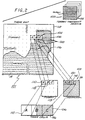
- an image generating system 10 develops simulated images of a terrain or external scene in real time for applications such as flight simulation systems.
- Several forms of such systems that are well known in the prior art include similar components, specifically a controller and image generator 12 driving a display unit 13 (FIGURE 1, bottom).
- a controller and image generator 12 driving a display unit 13 (FIGURE 1, bottom).
- the controller and generator 12 receives both detailed geo-specific data and general theme cell data to provide composite image data to the display unit 13.
- the controller and image generator 12 receives geo-specific data from a photo data source 18 (upper left) through a bus 20 for specific portions of the image display.
- the controller and image generator 12 receives generic data for theme cells through a bus 21 for other portions of the display.
- components of a dynamic display are provided either as photo data from the source 18 through the bus 20 or as theme cell data from an image texturing system (comprising the other blocks of FIGURE 1) through the bus 21.
- overall control and sequencing is accomplished by the controller and image generator 12 through a control bus 30 that is coupled to all other elements as indicated.
- the system 10 displays terrain image data rapidly and economically, without requiring vast amounts of memory.
- the image data represents simulated, visual images in real time in accordance with well known raster scan formats for generating images.
- the images are displayed on a display device 13 (lower right) such as a CRT or the like.
- FIGURE 2 Data for the theme cell portion of the display is detailed square-by-square by utilizing feature identification codes (FIC's) at the corners of each cell or square to specify the square contents with regard to themes, e.g. forest, water, etc.
- FIC's feature identification codes
- Contiguous squares of the same theme are detailed by data of adjacent treatments from an extensive array to avoid a patchwork appearance.
- Squares containing different themes are composed to selectively attain appropriate demarcations in accordance with rules as treated below.
- a theme map 101 (FIGURE 2, not relatively scaled) is stored in a theme map memory 14 (FIGURE 1, center).
- the map 101 is configured in a grid-like pattern of squares with FIC's (feature identification codes) at locations represented by array reference dots 102 (image reference identifiers) (FIGURE 2).
- FIC's feature identification codes
- array reference dots 102 image reference identifiers
- Four dots 102 are disposed at the four corners of each square or cell 106 in the array 104.
- the FIC's identify generic representations of the terrain at each corner dot 102.
- each square constitutes a theme cell 106 to be quartered and textured or detailed with specific terrain themes, e.g. forest, water, and so on.
- the dots 102 specifying FIC's are separated by forty meters, i.e. the theme cells 106 manifest low resolution data embracing squares of forty meters which enables effective storage.
- each theme cell 106 is textured or represented by a number of texels (pixels) arranged in a grid pattern of 32 x 32 texels.
- a maximum resolution 1.25 meters per texel is accommodated in a case where the FIC's are disposed at forty-meter intervals.
- the image generator and controller 12 maintains the theme cells 106 (FIGURE 2) in the theme map 101 current and updated with terrain image data corresponding to the area over which a flight is simulated.
- a frame buffer may be utilized for that function, as well known in the prior art.
- the theme map 101 (FIGURE 2) comprises an array of 1,024 x 1,024 theme cells 106.
- the cells 106 of the array, with specified feature identification codes, are then filled by theme data using modules addressing, from treatment arrays 103.
- the theme map 101, stored by the theme map memory 14 (FIGURE 1) is provided and maintained in the disclosed embodiment by disk storage as disclosed in greater detail below with reference to FIGURE 4.
- the controller and generator 12 first determines whether the geographic area involved is covered by available photographic data stored in the photo data source 18. Typically, if the geographic area is important to the purpose of the simulation, the photo data will be available. If so, using techniques and apparatus well known in the prior art, RGB (red, green, blue) texel data is fetched from the photo data source 18 and sent to the image generator 12 on a bus 20. Accordingly, the data is assembled in accordance with well known principles of the prior art.
- the system 10 composes theme cells from the theme map 101 and FIC data to create image texel data that is sent to the image generator 12.
- combination photo and theme data are utilized to formulate a dynamic display image.
- a terrain treatment arrays storage 22 (FIGURE 1, upper right) contains a library of theme arrays 103 (FIGURE 2, upper right). The images of various terrains are used in the construction of theme cells 106 (FIGURE 2). Each theme cell 106 (A, B, and C) is generated by use of the FIC's stored for the dots 102 which bound the theme cell 106 at each of its four corners.
- a theme map selector 24 selects current theme map data from the theme map memory 14.
- a theme map dissector 26 composes individual theme cells using the FIC data for the represented four dots 102 which bound each theme cell.
- the theme data for texturing individual theme cells is stored in a terrain treatment storage 22 (FIGURE 1) as a theme library of arrays 103 (FIGURE 2, upper right) comprising theme map treatment arrays 105 as for forest, water, and so on.
- Select themes indicated by feature identification codes are fetched from the storage 22 by a terrain pager 16 for use in an assembler or expander 28. Essentially, the assembler or expander textures theme cells with specified treatments as will now be considered.
- the four FIC's specified by the dots 104 (FIGURE 2) at the corners of each of the theme cells 106 determine which terrain treatments will appear in each theme cell 106.
- Each FIC indicates a type of terrain, such as forest, ocean, or residential.
- forests may be represented by the value "0”, oceans by the value "1”, residential areas by the value "2", and so on.
- the corner data of the dots 104 specified for each cell or block of the theme map 101 (FIGURE 2) serves to specify terrain treatments from the arrays 103 for texturing combination. For cells containing more than one treatment, e.g. forest and ocean, combinations may be based on rules as treated below.
- an appropriate terrain treatment array 105 from the arrays 103 simply is copied and mapped to the theme cell.
- the four corner dots 102 of the theme cell 106A (FIGURE 2) specify terrain covered with forest.
- the FIC values at the corners of the theme cell are 0, 0, 0, and 0, indicating all forest. Therefore, the image data for theme cell 106A is copied from an array segment 110 of a forest terrain treatment stored in the terrain treatment arrays storage 22 (FIGURE 1).
- a theme cell 106C (FIGURE 2) lies within a portion of the terrain theme map 101 entirely covered by residential area. Therefore, the image data for theme cell 106C is copied from an aligned position in the array 116, specifically array segment 114 of a residential terrain treatment.
- the theme cell 106B is generated by combining a first array segment 118 of the forest terrain treatment array 113, and a second array segment 120 from the residential terrain treatment array 116. The method for combining these two regions is explained in greater detail below.
- segments of the terrain treatment arrays are used cell-by-cell to generate the detailed contents of theme cells, subsequent segments are sequentially copied in sequential order from neighboring segments as illustrated in FIGURE 2.
- a raster pattern sequence may be employed taking segments from an array in adjacent blocks to preserve the original order. This technique avoids a patchwork appearance characteristic of repeating a single terrain segment for neighboring theme cells 106. Also, seamless edges are provided between terrain treatment segments in neighboring theme cells 106.
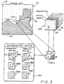
- FIGURES 3 and 5 in relation to the generation of boundaries between theme cells 106 in the theme map 101.
- Realistic boundaries within a theme cell 106X (FIGURE 3, lower right) between different terrain image portions (A, B, C, and D) are generated by considering the content of the adjoining terrain image portions.
- a sinuous merging rule organic
- an inorganic merging rule is necessary to prevent the sinuous merging of unnatural areas, as illustrated by the inorganic boundary 162 shown in FIGURE 5.
- Another key to creating effective combinations is to embody rules that avoid distinctive character patterns.
- An example of a distinctive character pattern might be a display with a sharp point like the tooth of a saw blade.
- a straight boundary across several theme cells 106 (FIGURE 2) between residential and forest might begin to look like a saw blade with the sharp point repeating at the theme cell interval.
- the rules quarter cells into areas A, B, C, and D.
- the inorganic rules are exemplified in a rules block 130 (FIGURE 3) and are used to quarter cell blocks 106a, 106b, and 106c defining straight lines.
- the cell block 106a is unequally quartered by two straight diagonal lines L1 and L2 defining corner apex areas B and C.
- a perpendicular straight diagonal line L3 extends between midpoints of the lines L1 and L2 to define corner areas A and D.
- the cell block 106d illustrates a theme allocation similar to that of cell block 106a, however, using an organic rule. Recapitulating, inorganic rules are used when any theme is flagged as inorganic. Otherwise organic rules ar used. Accordingly, the organic rules, e.g. block 106d, involve curved border lines. Note, for example, that the lines L4 and L5 of the cell block 106d are arcuate.
- the six rules illustrated in the rules block 130 are selectively employed to accommodate borders between terrain themes. If a bordering terrain theme is natural, an organic rule is applied. Conversely, unnatural terrain themes prompt selection of an inorganic rule. Application of the rules is based on the corner dot data specifying each cell. Other combination rules or classes of rules besides organic and inorganic are possible, but the rules shown are simple and effective.
- FIGURE 3 illustrates rule selection and application by the theme element assembler 28 (FIGURE 1).
- the regions labeled A, B, C, and D (FIGURE 3) illustrated in the rules block 130 are variously combined within single theme cells.
- the squares illustrate the terrain treatments indicated by the feature identification data for the corresponding corners of the theme cell.
- the combination rules of the block 130 are executed by detailing segments of the terrain treatment arrays 103 into the indicated regions of the theme cells in accordance with the rule specified.
- FIGURE 3 three corners (FIC's) of the theme cell 106 (in theme map 101) are located in forest terrain 112 and one corner is located in ocean terrain 115. Because the two terrains are natural, the theme element assembler or expander 28 (FIGURE 1) selects an organic rule as illustrated by the cells 106d, 106e, and 106f, specifically the first (cell 106d) because it tends to generate a natural corner. By applying the first organic rule (106d), the theme element assembler generates the resulting theme cell by selecting adjacent segments of a forest theme from array 112 for regions A, C, and D and by selecting a segment of an ocean theme 115 for the region B.
- the borders created by the organic combination rules should be varied slightly in sequences of application. This tends to avoid the problem discussed above attendant repeated application of a combination rule causing a repeated identical border between two regions on the theme map 101.
- Rule selection may be variously implemented in the assembler 28 (FIGURE 1) and in one embodiment may simply involve a truth table.
- the cell 106X (FIGURE 3) the lower, right corner (B) is to represent water while the remainder of the cell (A, C, and D) is to represent forest.
- the selection is apparent.
- a truth table can be addressed based on the four themes. In the assumed example: A 1 forest B 2 residential C 1 forest D 1 forest the truth table would indicate application of the first rule.
- the truth table will pseudo-randomly designate one of the alternatives.
- a current theme cell in process is blended to accomplish the representative display data. Recapitulating in that regard, if geo-specific data is available from the source 18 (FIGURE 1), it is used. Otherwise, the theme map memory is addressed by the map selector 24 and the dissector 26 to provide a set of four data units representing the themes at the corners of a theme cell.
- the corner data (feature identification data or FID) for the theme cell is supplied to the assembler 28, which also receives the theme data from the array storage 22 addressed by the pager 16. With such data, the assembler composes the theme cell in accordance with the principles described above, as by selecting individual texels.
- the image controller 12a determines which portions of data are required to form specific new portions of the image being generated.
- the controller 12a fetches information for these new portions through a texture paging controller 141.
- the texture paging controller 141 determines whether specific terrain texture data is available from disk storage 143 for the new portions. If specific terrain texture (photo data) is available, that data is provided directly to the image generator.
- the FIC data for the new portions is fetched by the texture paging controller 141 from the expander 28 as discussed above in relation to FIGURE 1.
- the FIC data for each theme cell is provided to the theme cell expander 28 which used the FIC data to generate theme cells that are representative of semi-specific image quality.
- the theme cell texture is then provided by the theme cell expander to the texture paging controller 141 which sends the texture information directly to the image generator 12b. Using the texture data information, the image generator generates the image on the display 13.
Landscapes
- Engineering & Computer Science (AREA)
- Physics & Mathematics (AREA)
- Theoretical Computer Science (AREA)
- General Physics & Mathematics (AREA)
- Geometry (AREA)
- Computer Graphics (AREA)
- Software Systems (AREA)
- Aviation & Aerospace Engineering (AREA)
- Educational Administration (AREA)
- Educational Technology (AREA)
- Business, Economics & Management (AREA)
- Remote Sensing (AREA)
- Computer Hardware Design (AREA)
- Processing Or Creating Images (AREA)
- Instructional Devices (AREA)
Claims (8)
- Bildstrukturiersystem (10) zum Erzeugen simulierter Gelände- oder Außenszenen für beispielsweise Anwendungen wie die Flugausbildung, wobei das Bildstrukturiersystem (10) einen Bildgenerator (12) zum Generieren von visuellen Echtzeitbildern zur Anzeige auf einer Anzeigevorrichtung (13) und eine Einrichtung zum Speichern (14) einer Themenkarte (101) aufweist, die aus einer Mehrzahl von Themenzellen (106) gebildet ist, die in einem Gittermuster angeordnet sind, wobei jeder Themenzelle Indexidentifikatoren (FICs) zugeordnet sind, die charakteristische geographische Geländethemen angeben, wobei das Bildstrukturiersystem gekennzeichnet ist durch:
eine Einrichtung zum Speichern von Geländebehandlungsfeldern (103) der charakteristischen geographischen Geländethemen zum Anwenden auf die Themenzellen (106); und eine Einrichtung zum Anwenden mindestens eines Teils mindestens eines der Geländebehandlungsfelder (103) auf die Themenzellen (106), wodurch eine einzelne Geländebehandlung Anwendung findet, wenn die Indexidentifikatoren für eine Themenzelle (106) den gleichen Wert haben, während eine Mehrzahl von Geländebehandlungen Anwendung findet, wenn die Indexidentifikatoren für eine Themenzelle (106) nicht den gleichen Wert haben, wobei die relevante Themenzelle sich zusammensetzt aus einer Kombination von Geländen, wie sie von den Indexidentifikationen angegeben werden, so daß ein Regeltyp (106a - 106c) Anwendung findet im Fall natürlicher Gebiete, und ein anderer Regeltyp (106d - 106f) Anwendung im Fall unnatürlicher Gebiete findet, und wobei in beiden Fällen zwecks Kontinuität Grenzen an vorbestimmten Verbindungsstellen enden. - Bildstrukturiersystem (10) nach Anspruch 1, zusätzlich gekennzeichnet durch eine Einrichtung zum Generieren eines ausgewählten Hochauflösungsabschnitts in dem visuellen Echtzeitbild aus fotografischen Daten, die in einer Fotodatenquelle (18) gespeichert sind.
- Bildstrukturiersystem (10) nach Anspruch 1, bei dem die Geländebehandlungsfelder (103) größer sind als die Intervalle zwischen den Indexidentifikatoren in dem Gittermuster.
- Bildstrukturiersystem (10) nach Anspruch 1, bei dem die Geländebehandlungsfelder (103), die jedes von den charakteristischen geographischen Geländethemen darstellen, eine Mehrzahl von Unterabschnitten besitzen, die in einem Feld angeordnet sind, wobei jeder Unterabschnitt sequentiell ausgewählt wird, wenn er auf die Indexidentifikatoren angewendet wird.
- Bildstrukturiersystem nach Anspruch 1, zusätzlich gekennzeichnet durch vier Indexidentifikatoren zum Angeben des Geländetyps.
- Bildstrukturiersystem (10) nach Anspruch 1, bei dem der eine Regeltyp ein Regeltyp für einen geschlängelten Übergang ist.
- Bildstrukturiersystem (10) nach Anspruch 1, bei dem der andere Regeltyp ein Regeltyp für einen unnatürlichen Übergang ist.
- Bildstrukturiersystem (10) nach Anspruch 1, bei dem in beiden Fällen die Grenzen an dem Rand der relevanten Themenzelle etwa am Mittelpunkt zwischen den Ecken enden.
Applications Claiming Priority (3)
| Application Number | Priority Date | Filing Date | Title |
|---|---|---|---|
| US83782792A | 1992-02-18 | 1992-02-18 | |
| US837827 | 1992-02-18 | ||
| PCT/US1993/001428 WO1993016440A1 (en) | 1992-02-18 | 1993-02-17 | Image texturing system having theme cells |
Publications (2)
| Publication Number | Publication Date |
|---|---|
| EP0627103A1 EP0627103A1 (de) | 1994-12-07 |
| EP0627103B1 true EP0627103B1 (de) | 1996-01-10 |
Family
ID=25275552
Family Applications (1)
| Application Number | Title | Priority Date | Filing Date |
|---|---|---|---|
| EP93906037A Expired - Lifetime EP0627103B1 (de) | 1992-02-18 | 1993-02-17 | Bildtexturierungssystem mit themazellen. |
Country Status (5)
| Country | Link |
|---|---|
| US (1) | US5748867A (de) |
| EP (1) | EP0627103B1 (de) |
| JP (1) | JPH07504055A (de) |
| DE (1) | DE69301308T2 (de) |
| WO (1) | WO1993016440A1 (de) |
Families Citing this family (58)
| Publication number | Priority date | Publication date | Assignee | Title |
|---|---|---|---|---|
| US8352400B2 (en) | 1991-12-23 | 2013-01-08 | Hoffberg Steven M | Adaptive pattern recognition based controller apparatus and method and human-factored interface therefore |
| US7895076B2 (en) | 1995-06-30 | 2011-02-22 | Sony Computer Entertainment Inc. | Advertisement insertion, profiling, impression, and feedback |
| US8574074B2 (en) | 2005-09-30 | 2013-11-05 | Sony Computer Entertainment America Llc | Advertising impression determination |
| US6606034B1 (en) | 1995-07-31 | 2003-08-12 | Honeywell International Inc. | Terrain awareness system |
| FR2738871B1 (fr) * | 1995-09-19 | 1997-11-14 | Elf Aquitaine | Procede pour realiser une representation des textures d'une structure geologique |
| JP3312560B2 (ja) * | 1996-07-11 | 2002-08-12 | ヤマハ株式会社 | テクスチャマッピング装置 |
| KR100219161B1 (ko) * | 1996-10-23 | 1999-09-01 | 윤종용 | 지도데이타 인덱스구축/검색방법 및 이를 적용한 지도데이타베이스운용시스템 |
| US6130670A (en) * | 1997-02-20 | 2000-10-10 | Netscape Communications Corporation | Method and apparatus for providing simple generalized conservative visibility |
| US5949425A (en) * | 1997-11-25 | 1999-09-07 | Terrain Experts, Inc. | Terrain representation with polygonal seams |
| US6191793B1 (en) | 1998-04-01 | 2001-02-20 | Real 3D, Inc. | Method and apparatus for texture level of detail dithering |
| US6362817B1 (en) * | 1998-05-18 | 2002-03-26 | In3D Corporation | System for creating and viewing 3D environments using symbolic descriptors |
| US7904187B2 (en) | 1999-02-01 | 2011-03-08 | Hoffberg Steven M | Internet appliance system and method |
| JP4559555B2 (ja) * | 1999-03-16 | 2010-10-06 | 株式会社日立製作所 | 立体地図表示方法およびナビゲーション装置 |
| US7002601B1 (en) | 2000-05-04 | 2006-02-21 | Microsoft Corporation | Method and apparatus for rendering a quadrangle primitive |
| US8751310B2 (en) | 2005-09-30 | 2014-06-10 | Sony Computer Entertainment America Llc | Monitoring advertisement impressions |
| JP2005505362A (ja) | 2001-10-10 | 2005-02-24 | ソニー・コンピュータ・エンタテインメント・アメリカ・インク | スムースなゲームプレーのためのゲームソフトウェアを動的に読み込むシステムと方法 |
| FR2841977B1 (fr) * | 2002-07-05 | 2004-09-10 | Thales Sa | Procede d'aide a la navigation d'un areonef et dispositif correspondant |
| FR2854374B1 (fr) * | 2003-05-02 | 2006-05-19 | Thales Sa | Aeronef pourvu de moyens d'affichage de terrain survole |
| US8133115B2 (en) * | 2003-10-22 | 2012-03-13 | Sony Computer Entertainment America Llc | System and method for recording and displaying a graphical path in a video game |
| US8207966B2 (en) * | 2004-05-26 | 2012-06-26 | Sony Online Entertainment Llc | Terrain editor tool for rule-based procedural terrain generation |
| US8115765B2 (en) * | 2004-05-26 | 2012-02-14 | Sony Online Entertainment Llc | Rule-based procedural terrain generation |
| US20060164417A1 (en) * | 2004-07-28 | 2006-07-27 | Lockheed Martin Corporation | Imagery-based synthetic environment for computer generated forces |
| US8763157B2 (en) | 2004-08-23 | 2014-06-24 | Sony Computer Entertainment America Llc | Statutory license restricted digital media playback on portable devices |
| US20060071933A1 (en) | 2004-10-06 | 2006-04-06 | Sony Computer Entertainment Inc. | Application binary interface for multi-pass shaders |
| US7636126B2 (en) | 2005-06-22 | 2009-12-22 | Sony Computer Entertainment Inc. | Delay matching in audio/video systems |
| US8626584B2 (en) | 2005-09-30 | 2014-01-07 | Sony Computer Entertainment America Llc | Population of an advertisement reference list |
| EP1775712A1 (de) * | 2005-10-13 | 2007-04-18 | Sony Ericsson Mobile Communications AB | Automatisches Herstellen von Themen |
| US20070118425A1 (en) | 2005-10-25 | 2007-05-24 | Podbridge, Inc. | User device agent for asynchronous advertising in time and space shifted media network |
| US11004089B2 (en) | 2005-10-25 | 2021-05-11 | Sony Interactive Entertainment LLC | Associating media content files with advertisements |
| US10657538B2 (en) | 2005-10-25 | 2020-05-19 | Sony Interactive Entertainment LLC | Resolution of advertising rules |
| US8676900B2 (en) | 2005-10-25 | 2014-03-18 | Sony Computer Entertainment America Llc | Asynchronous advertising placement based on metadata |
| US7880746B2 (en) | 2006-05-04 | 2011-02-01 | Sony Computer Entertainment Inc. | Bandwidth management through lighting control of a user environment via a display device |
| US7965859B2 (en) | 2006-05-04 | 2011-06-21 | Sony Computer Entertainment Inc. | Lighting control of a user environment via a display device |
| CN101438526B (zh) | 2006-05-05 | 2013-03-13 | 美国索尼电脑娱乐公司 | 广告旋转 |
| EP2104930A2 (de) | 2006-12-12 | 2009-09-30 | Evans & Sutherland Computer Corporation | System und methode zum ausgleichen des rgb-licht in einem monomodulator projektor |
| US8289326B2 (en) * | 2007-08-16 | 2012-10-16 | Southwest Research Institute | Image analogy filters for terrain modeling |
| US8416247B2 (en) | 2007-10-09 | 2013-04-09 | Sony Computer Entertaiment America Inc. | Increasing the number of advertising impressions in an interactive environment |
| US8769558B2 (en) | 2008-02-12 | 2014-07-01 | Sony Computer Entertainment America Llc | Discovery and analytics for episodic downloaded media |
| US8358317B2 (en) | 2008-05-23 | 2013-01-22 | Evans & Sutherland Computer Corporation | System and method for displaying a planar image on a curved surface |
| US8702248B1 (en) | 2008-06-11 | 2014-04-22 | Evans & Sutherland Computer Corporation | Projection method for reducing interpixel gaps on a viewing surface |
| US8077378B1 (en) | 2008-11-12 | 2011-12-13 | Evans & Sutherland Computer Corporation | Calibration system and method for light modulation device |
| CN101581584B (zh) * | 2009-02-27 | 2011-05-04 | 泰瑞数创科技(北京)有限公司 | 一种利用三维地形图进行航迹分析的方法 |
| US8763090B2 (en) | 2009-08-11 | 2014-06-24 | Sony Computer Entertainment America Llc | Management of ancillary content delivery and presentation |
| US8419534B2 (en) * | 2009-09-30 | 2013-04-16 | Disney Enterprises, Inc. | Systems and methods for using images to generate gameplay content |
| US10786736B2 (en) | 2010-05-11 | 2020-09-29 | Sony Interactive Entertainment LLC | Placement of user information in a game space |
| US9342817B2 (en) | 2011-07-07 | 2016-05-17 | Sony Interactive Entertainment LLC | Auto-creating groups for sharing photos |
| US9641826B1 (en) | 2011-10-06 | 2017-05-02 | Evans & Sutherland Computer Corporation | System and method for displaying distant 3-D stereo on a dome surface |
| KR20150108241A (ko) * | 2014-03-17 | 2015-09-25 | 한국전자통신연구원 | 빠르고 자연스러운 지형 생성 방법 및 그 장치 |
| US9483847B2 (en) | 2014-03-28 | 2016-11-01 | Cae, Inc. | System and method for rendering virtual contaminants |
| CA2847863C (en) | 2014-03-28 | 2017-09-19 | Cae Inc. | System and method for modeling virtual contaminants |
| US20160292919A1 (en) | 2015-03-31 | 2016-10-06 | Cae Inc. | Modular Infrastructure For An Interactive Computer Program |
| US9473767B1 (en) | 2015-03-31 | 2016-10-18 | Cae Inc. | Multifactor eye position identification in a display system |
| US9754506B2 (en) | 2015-03-31 | 2017-09-05 | Cae Inc. | Interactive computer program with virtualized participant |
| US10846779B2 (en) | 2016-11-23 | 2020-11-24 | Sony Interactive Entertainment LLC | Custom product categorization of digital media content |
| US10860987B2 (en) | 2016-12-19 | 2020-12-08 | Sony Interactive Entertainment LLC | Personalized calendar for digital media content-related events |
| JP6767319B2 (ja) * | 2017-07-31 | 2020-10-14 | 株式会社ソニー・インタラクティブエンタテインメント | 情報処理装置およびファイルコピー方法 |
| US10931991B2 (en) | 2018-01-04 | 2021-02-23 | Sony Interactive Entertainment LLC | Methods and systems for selectively skipping through media content |
| US11170568B2 (en) | 2020-01-23 | 2021-11-09 | Rockwell Collins, Inc. | Photo-realistic image generation using geo-specific data |
Family Cites Families (16)
| Publication number | Priority date | Publication date | Assignee | Title |
|---|---|---|---|---|
| US3816726A (en) * | 1972-10-16 | 1974-06-11 | Evans & Sutherland Computer Co | Computer graphics clipping system for polygons |
| US4645459A (en) * | 1982-07-30 | 1987-02-24 | Honeywell Inc. | Computer generated synthesized imagery |
| US4677576A (en) * | 1983-06-27 | 1987-06-30 | Grumman Aerospace Corporation | Non-edge computer image generation system |
| US4615013A (en) * | 1983-08-02 | 1986-09-30 | The Singer Company | Method and apparatus for texture generation |
| US4586038A (en) * | 1983-12-12 | 1986-04-29 | General Electric Company | True-perspective texture/shading processor |
| US4821212A (en) * | 1984-08-08 | 1989-04-11 | General Electric Company | Three dimensional texture generator for computed terrain images |
| EP0513474A1 (de) * | 1986-09-11 | 1992-11-19 | Hughes Aircraft Company | Digitales System für visuelle und Sensorsimulation zur Erzeugung von realistischen Szenen |
| US4868771A (en) * | 1987-03-30 | 1989-09-19 | General Electric Company | Computer image generation with topographical response |
| US5379371A (en) * | 1987-10-09 | 1995-01-03 | Hitachi, Ltd. | Displaying method and apparatus for three-dimensional computer graphics |
| US4974176A (en) * | 1987-12-18 | 1990-11-27 | General Electric Company | Microtexture for close-in detail |
| US4899293A (en) * | 1988-10-24 | 1990-02-06 | Honeywell Inc. | Method of storage and retrieval of digital map data based upon a tessellated geoid system |
| US4985854A (en) * | 1989-05-15 | 1991-01-15 | Honeywell Inc. | Method for rapid generation of photo-realistic imagery |
| US5367615A (en) * | 1989-07-10 | 1994-11-22 | General Electric Company | Spatial augmentation of vertices and continuous level of detail transition for smoothly varying terrain polygon density |
| US5179638A (en) * | 1990-04-26 | 1993-01-12 | Honeywell Inc. | Method and apparatus for generating a texture mapped perspective view |
| US5214757A (en) * | 1990-08-07 | 1993-05-25 | Georesearch, Inc. | Interactive automated mapping system |
| US5194969A (en) * | 1990-12-04 | 1993-03-16 | Pixar | Method for borderless mapping of texture images |
-
1993
- 1993-02-17 WO PCT/US1993/001428 patent/WO1993016440A1/en active IP Right Grant
- 1993-02-17 JP JP5514344A patent/JPH07504055A/ja active Pending
- 1993-02-17 EP EP93906037A patent/EP0627103B1/de not_active Expired - Lifetime
- 1993-02-17 DE DE69301308T patent/DE69301308T2/de not_active Expired - Fee Related
- 1993-07-06 US US08/088,447 patent/US5748867A/en not_active Expired - Lifetime
Also Published As
| Publication number | Publication date |
|---|---|
| EP0627103A1 (de) | 1994-12-07 |
| DE69301308T2 (de) | 1996-05-23 |
| WO1993016440A1 (en) | 1993-08-19 |
| US5748867A (en) | 1998-05-05 |
| DE69301308D1 (de) | 1996-02-22 |
| JPH07504055A (ja) | 1995-04-27 |
Similar Documents
| Publication | Publication Date | Title |
|---|---|---|
| EP0627103B1 (de) | Bildtexturierungssystem mit themazellen. | |
| US4586038A (en) | True-perspective texture/shading processor | |
| US5535374A (en) | Method and apparatus for generating images simulating non-homogeneous fog effects | |
| US4905164A (en) | Method for modulating color for effecting color cell texture | |
| EP0840257B1 (de) | Beleuchtungs- und Schattensimulation in einem computergestützten graphischen oder Bilderzeugungssystem | |
| US4825391A (en) | Depth buffer priority processing for real time computer image generating systems | |
| US5179638A (en) | Method and apparatus for generating a texture mapped perspective view | |
| US4918625A (en) | Method and apparatus for processing translucent objects | |
| US6747649B1 (en) | Terrain rendering in a three-dimensional environment | |
| US4343037A (en) | Visual display systems of the computer generated image type | |
| US4667190A (en) | Two axis fast access memory | |
| US5338200A (en) | Method and apparatus for generating an elliptical image | |
| EP0137110A1 (de) | Vorrichtung zum Erzeugen von Bildfolgen, die den Eindruck einer Bewegung hervorrufen | |
| US5384719A (en) | Image generator for simulating the illumination effects of a vehicle-mounted light source on an image displayed on a screen | |
| US5823780A (en) | Apparatus and method for simulation | |
| US6445395B1 (en) | Method and apparatus for radiometrically accurate texture-based lightpoint rendering technique | |
| US9098939B2 (en) | System and method of generating light maps | |
| JPH10134206A (ja) | コンピュータグラフィックス/画像生成装置の鏡面反射のシミュレーション装置および方法 | |
| EP0313101A2 (de) | Fraktionierte Pixelabbildung in einem rechnergesteuerten Abbildungssystem | |
| JPH0154749B2 (de) | ||
| US6377274B1 (en) | S-buffer anti-aliasing method | |
| EP0450978A2 (de) | Gerät zur visuellen Anzeigeerzeugung | |
| JPH0154748B2 (de) | ||
| GB2242810A (en) | Addressing a texture memory | |
| Mackey et al. | DTIC SFLECTE |
Legal Events
| Date | Code | Title | Description |
|---|---|---|---|
| PUAI | Public reference made under article 153(3) epc to a published international application that has entered the european phase |
Free format text: ORIGINAL CODE: 0009012 |
|
| 17P | Request for examination filed |
Effective date: 19940818 |
|
| AK | Designated contracting states |
Kind code of ref document: A1 Designated state(s): DE GB |
|
| 17Q | First examination report despatched |
Effective date: 19950306 |
|
| GRAA | (expected) grant |
Free format text: ORIGINAL CODE: 0009210 |
|
| AK | Designated contracting states |
Kind code of ref document: B1 Designated state(s): DE GB |
|
| REF | Corresponds to: |
Ref document number: 69301308 Country of ref document: DE Date of ref document: 19960222 |
|
| PLBE | No opposition filed within time limit |
Free format text: ORIGINAL CODE: 0009261 |
|
| STAA | Information on the status of an ep patent application or granted ep patent |
Free format text: STATUS: NO OPPOSITION FILED WITHIN TIME LIMIT |
|
| 26N | No opposition filed | ||
| REG | Reference to a national code |
Ref country code: GB Ref legal event code: IF02 |
|
| PGFP | Annual fee paid to national office [announced via postgrant information from national office to epo] |
Ref country code: DE Payment date: 20020306 Year of fee payment: 10 |
|
| PG25 | Lapsed in a contracting state [announced via postgrant information from national office to epo] |
Ref country code: DE Free format text: LAPSE BECAUSE OF NON-PAYMENT OF DUE FEES Effective date: 20030902 |
|
| REG | Reference to a national code |
Ref country code: GB Ref legal event code: 732E Free format text: REGISTERED BETWEEN 20090827 AND 20090902 |
|
| PGFP | Annual fee paid to national office [announced via postgrant information from national office to epo] |
Ref country code: GB Payment date: 20120224 Year of fee payment: 20 |
|
| REG | Reference to a national code |
Ref country code: GB Ref legal event code: PE20 Expiry date: 20130216 |
|
| PG25 | Lapsed in a contracting state [announced via postgrant information from national office to epo] |
Ref country code: GB Free format text: LAPSE BECAUSE OF EXPIRATION OF PROTECTION Effective date: 20130216 |