EP0508405A1 - Système de localisation et récepteur GPS - Google Patents
Système de localisation et récepteur GPS Download PDFInfo
- Publication number
- EP0508405A1 EP0508405A1 EP92106075A EP92106075A EP0508405A1 EP 0508405 A1 EP0508405 A1 EP 0508405A1 EP 92106075 A EP92106075 A EP 92106075A EP 92106075 A EP92106075 A EP 92106075A EP 0508405 A1 EP0508405 A1 EP 0508405A1
- Authority
- EP
- European Patent Office
- Prior art keywords
- gps
- signal
- digital signal
- mobile station
- converting
- Prior art date
- Legal status (The legal status is an assumption and is not a legal conclusion. Google has not performed a legal analysis and makes no representation as to the accuracy of the status listed.)
- Granted
Links
Images


Classifications
-
- G—PHYSICS
- G01—MEASURING; TESTING
- G01S—RADIO DIRECTION-FINDING; RADIO NAVIGATION; DETERMINING DISTANCE OR VELOCITY BY USE OF RADIO WAVES; LOCATING OR PRESENCE-DETECTING BY USE OF THE REFLECTION OR RERADIATION OF RADIO WAVES; ANALOGOUS ARRANGEMENTS USING OTHER WAVES
- G01S19/00—Satellite radio beacon positioning systems; Determining position, velocity or attitude using signals transmitted by such systems
- G01S19/01—Satellite radio beacon positioning systems transmitting time-stamped messages, e.g. GPS [Global Positioning System], GLONASS [Global Orbiting Navigation Satellite System] or GALILEO
- G01S19/03—Cooperating elements; Interaction or communication between different cooperating elements or between cooperating elements and receivers
- G01S19/09—Cooperating elements; Interaction or communication between different cooperating elements or between cooperating elements and receivers providing processing capability normally carried out by the receiver
-
- G—PHYSICS
- G07—CHECKING-DEVICES
- G07C—TIME OR ATTENDANCE REGISTERS; REGISTERING OR INDICATING THE WORKING OF MACHINES; GENERATING RANDOM NUMBERS; VOTING OR LOTTERY APPARATUS; ARRANGEMENTS, SYSTEMS OR APPARATUS FOR CHECKING NOT PROVIDED FOR ELSEWHERE
- G07C5/00—Registering or indicating the working of vehicles
- G07C5/008—Registering or indicating the working of vehicles communicating information to a remotely located station
-
- G—PHYSICS
- G07—CHECKING-DEVICES
- G07C—TIME OR ATTENDANCE REGISTERS; REGISTERING OR INDICATING THE WORKING OF MACHINES; GENERATING RANDOM NUMBERS; VOTING OR LOTTERY APPARATUS; ARRANGEMENTS, SYSTEMS OR APPARATUS FOR CHECKING NOT PROVIDED FOR ELSEWHERE
- G07C5/00—Registering or indicating the working of vehicles
- G07C5/08—Registering or indicating performance data other than driving, working, idle, or waiting time, with or without registering driving, working, idle or waiting time
- G07C5/0841—Registering performance data
- G07C5/085—Registering performance data using electronic data carriers
- G07C5/0858—Registering performance data using electronic data carriers wherein the data carrier is removable
Definitions
- the present invention relates to a system for measuring a current position of an automobile or the like by using a global positioning system (GPS) and a receiver for the GPS system.
- GPS global positioning system
- NVSTAR Navigation System with Time and Range
- GPS receiver unit as well as a car navigation system provided with the GPS receiver are made commercially available. In near future, the GPS receiver may apply to more various fields.
- the GPS known by the present inventors is designed to capture an electromagnetic wave transmitted from a GPS satellite going around the earth as keeping the orbit highly accurate, measure the time when the wave reaches the GPS, and measure the distance between the GPS satellite and the receiving mobile station (user) based on the measured time. The similar measurement is carried out in the other two GPS satellites for deriving the position of the mobile station.
- the unknown position of the mobile station can be derived by the positions of the three GPS satellites obtained-from the orbit information and the measured distances from the station to each the GPS satellite.
- the measured time has a uncertain component.
- a time lag ⁇ t as one variant and capturing the positions of the four GPS satellites, it is possible to accurately measure the position of the GPS mobile station.
- the GPS has a capability of measuring the position with high precision of about several tens to hundreds meter.
- the mobile station is capable of grasping the position of itself and the base station for managing two or more mobile stations loaded on a car, for example, is also capable of managing the position of each mobile station.
- the managing result is used for managing an everyday operation range or providing a service for a user.
- the description will be directed to the known GPS position measuring system.
- a GPS signal is received through a receiving antenna.
- the received signal is sent to an amplifying and frequency converting circuit in which the signal is amplified and then is converted into a signal on an IF (Intermediate Frequency) band (referred to as an IF signal).
- the resulting signal is sent to an analog-to-digital converter.
- the A/D converter the signal is directly converted into a digital signal or the base-band signal is converted into a digital signal.
- the digital signal is sent to a digital signal processing circuit in which a spectrum back-diffusion process, a digital demodulating process and a position measuring process are carried out with respect to the digital signal for deriving the data about the measured distance and the satellite orbit.
- GPS satellites are required for measuring the position of a target object. Hence, at first, four satellites are selected from all GPS satellites which can be captured. As a determining criterion for the selection, a GDOP (Geometrical Dilution of Precision) is used.
- the GDOP is a coefficient standing for a geometrical precision degradation.
- the selecting process at first one GPS satellite is captured so that a signal received from the captured GPS satellite is converted to the corresponding digital signal and collecting pieces of data about orbits of all the GPS satellites is performed.
- the collective data being referred to as an almanac.
- the GDOP is derived.
- the four satellites are allowed to be selected so that the measuring error may become minimum in the selected combination.
- the GPS signals are received for collecting ephemerides (data about orbits of the selected satellites).
- the combination of the satellites bringing the GDOP to the second smallest value is selected.
- the foregoing process is carried out with respect to the selected combination.
- a pseudo-distance between the GPS receiver and each satellite is derived.
- the recent GPS receiver is required to provide the digital signal processing circuits corresponding to four or more channels.
- the data about the pseudo-distances and satellite orbits obtained by the above process is applied to a position deriving circuit for calculating a position of each satellite, operating an quartic equation, and performing the coordinate conversion, the statistical processing and the like.
- the measured position latitude, longitude and height, for example
- the GPS receiver itself can be obtained.
- the position data is sent to a writing unit in which the data is written to a memory card (or IC card) together with a measuring time.
- the position data and the measuring time are sequentially written on the memory card.
- the memory card containing the position data and the measuring times accumulated thereon is transferred to the base station.
- the memory card is inserted to the reading unit for reading the position data and the measuring times from the card.
- the data is sent to a computer having a operation managing program built therein. In the computer, for example, the one-day operation management of the car is derived from the data.
- the foregoing related art provides a circuit for processing a GPS signal and a circuit for deriving the position of the mobile station on each mobile station. It means that each mobile station is required to have a numerical control oscillator (NCO), a digital signal processor (DSP), a 16-bit central processing unit (CPU), a numerical processor and the like. Further, for measuring the position of the mobile station, it is necessary to prepare the four or more channels or use a high-speed IC for operating one channel at high speed. As a result, each mobile station has so large and costly hardware. It is difficult and disadvantageous in light of the cost to provide such a mobile station or a GPS receiver in each one of a lot of cars.
- NCO numerical control oscillator
- DSP digital signal processor
- CPU 16-bit central processing unit
- the GPS data is composed of repetitive master frames.
- One master frame consists of 25 pages (main frames).
- One page consists of five sub frames.
- Each sub frame is arranged to have 300 bits.
- the first sub frame contains an amending coefficient about a timer of the satellite
- the second and the third sub frames contain the orbit data of the satellite
- the fourth and the fifth sub frames contain the almanac and an amending coefficient about an ionospheric layer, ant etc.. Since the first to the third sub frames are completed at each page, all the orbit data of the GPS satellite is contained in one page.
- the fourth and the fifth sub frames are arranged to be completed at each frame master. That is, the remaining part of the almanac, or the orbit data of another GPS satellites is arranged to be dispersed in each page. It means that the orbit data about all the satellites can be obtained over 25 pages.
- the bit rate is 50 bps, 30 seconds are needed for reading one page. That is, for reading one master frame, 12.5 minutes are needed. It means that for obtaining the almanac, it is necessary to receive a GPS signal for as long a time as 12.5 minutes.
- the receiver To receive the almanac data, the receiver is required to support its receiving antenna directed toward the sky for 12.5 minutes or more. This is unpractical. Further, it takes 12.5 minutes or longer to measure the position of the target object. This is a long time.
- the digital signal processing circuits corresponding to the satellites (6 to 8) located within a signal-receivable field are prepared, the one-frame data is received from all the satellites located within the receivable field, and the DGOP is derived by using the data in place of the almanac.
- the receiving time it is possible to reduce the receiving time to about 30 seconds.
- the GPS-based position measuring system includes at least one mobile station and a base station associated with the mobile stations.
- the mobile station is provided with mechanism for receiving a GPS signal from a GPS satellite, mechanism for converting the received GPS signal into a signal on an intermediate-frequency (IF) band, mechanism for converting the analog signal on the IF band into a digital signal; and mechanism for processing the digital signal in order to transfer the processed signal to the base station.
- the base station is provided with mechanism for deriving a position of the mobile station by using the digital signal transferred from the mobile station to the base station.
- the processing mechanism includes mechanism for storing a digital signal converted by the converting mechanism.
- the storing mechanism is one of a memory card, an IC card, another type of semiconductor storage device, and a magnetic medium.
- the mobile station denotes a GPS device located at the place to be measured.
- the mobile station may be moving or stopped.
- the mobile station serves to convert the GPS signal received from the GPS satellite into an IF signal and sample and quantize the IF signal for producing a digital signal. Then, the digital signal is sent to the base station. That is, the digital signal is stored on a storage medium or is transmitted by radio.
- the GPS receiver includes mechanism for receiving a plurality of GPS (Global Positioning System) signals from a plurality of GPS satellites, mechanism for converting a signal involving the received GPS signals into an IF signal, mechanism for converting the IF analog signal into a digital signal, mechanism for storing the converted digital signal before signal processing with respect to deriving a position of the GPS receiver, mechanism for reading the digital signal from the storing mechanism, and mechanism for deriving the position of the GPS receiver by using the read digital signal.
- GPS Global Positioning System
- the reading mechanism is arranged to read the digital signal from the storing mechanism at a faster speed than the writing speed to the storage mechanism.
- the GPS signal received from the GPS satellite is converted into an IF signal.
- the IF signal is quantized for converting the signal into a digital signal.
- the digital signal corresponding to any period of time is temporarily stored in the storing mechanism.
- the digital signal read from the storing mechanism is processed on the time series for performing the measurement of the position.
- Such time-series processing is equivalent to preparation of a multi-channel digital signal processing unit and allows the data about each satellite to be collected, resulting in eliminating the necessity of the almanac.
- the GPS receiver of this invention does not need to consume a large period of time for collecting the almanac. This results in reducing the measuring time to a quite short time without having to increase the hardware amount.
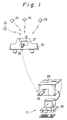
- Fig. 1 is an illustration schematically showing an arrangement of a system for managing the operation of a car such as a taxi.
- a mobile station 20 is a car and a base station 21 is a managing office for the car.
- the mobile station 20 provides a mobile-station device 27 which is arranged to receive GPS signals from the GPS satellites 22, 23, 24, and 25, convert the GPS signals into a signal on an IF signal, sample and quantize the IF signal for producing a digital signal, and write the digital signal into a memory card (or IC card) 26.
- the GPS satellite employs a spectrum diffusion communication system.
- the base station 21 provides a base-station device 28 which is arranged to read the data from a memory card, process the digital signal of the GPS, and derive a position of the mobile station 20 and a personal computer 20 which operates to manage the operation based on the data about the measured position and the measuring time.
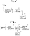
- Fig. 2 is a block diagram showing the mobile-station device 27 provided in the system shown in Fig. 1.
- the mobile-station device is provided with an antenna 30, an amplifying and frequency converting circuit 31, an analog-to-digital (A/D) converter 32, and a writing unit 33.
- the GPS signal is received from the GPS satellite to the device through the antenna 30.
- the amplifying and frequency converting circuit 31 contains a pre-amplifying section for amplifying the received GPS signal. Then, the circuit 31 operates to convert the amplified signal into the IF signal.
- the IF signal is sent to the A/D converter 32. In the converter 32, the IF signal is converted into a digital signal.
- the writing unit 33 serves to directly write the digital signal onto a memory card 26 (see Fig. 1).
- a local oscillating signal (not shown) is applied to the circuit 31. The signal is produced in an oscillator (not shown).
- Fig. 3 is a block diagram showing a base-station device 28 included in the system shown in Fig. 1.
- the base-station device 28 is provided with a reading unit 34, a digital signal processing circuit 35, a position deriving circuit 37, an auxiliary data circuit 36 and a computer 29.
- the reading unit 34 serves to read a digital signal stored in the memory card 26 (see Fig. 1).
- the digital signal processing circuit 35 operates to sense a synchronous phase about each of the GPS satellites 22, 23, 24 and 25 and derive pseudo-distances from all of the GPS satellites.
- the position deriving circuit 37 operates to derive the data about the measured position based on the derived pseudo-distance and the position data of each GPS satellite given by the auxiliary data circuit 36.
- the personal computer 29 manages the operation based on the data about the measured position and the measuring time.
- Figs. 4 and 5 are flowcharts showing a flow of data process done in the mobile station and the base station.
- the program shown in Fig. 4 is executed at a given interval and a digital signal is recorded on the memory card.
- a signal is received from each of the GPS satellites 22, 23, 24 and 25 through the antenna 30.
- the RF (Radio Frequency) signal is converted down to the IF signal in the amplifying and frequency converting circuit 31.
- the IF signal converted in the circuit 31 is a signal obtained by modulating a carrier by means of a BPSK (Bi-Phase Shift Keying) method.
- the GPS receiver employs the spectrum diffusion communication system in which the GPS signals sent from the GPS satellites (located within a signal-receivable field of view) are located on the band in an overlapping manner.
- the IF signal formed in an overlapped manner is converted into a digital signal in the A/D converter 32.
- the relevant data is recorded on the memory card 26.
- the data contains this digital signal on a carrier level and a time mark indicating when the signal is collected (for example, a digital value indicating **hour **minute **second).
- the mobile station 20 On the base station 21, the mobile station 20 is returned there so that the memory card 26 may be brought into the base-station device 28. Then, the program shown in Fig. 5 is executed.
- the digital data recorded on the memory card 26 is read from the reading unit 34.
- all the digital data may be stored in memory (not shown).
- the successive process is executed by reading a part of data from the memory.
- the digital data at a given interval may be read from the memory card each time the later process is executed.
- the diffusion code for each of the GPS satellites 22, 23, 24 and 25 (located within a signal-receivable field of view) is multiplied by the read digital data for sensing the synchronous phase of each satellite in the digital signal processing circuit 35.
- the digital signal processing circuit 35 serves to measure the time when an electromagnetic wave from each GPS satellite reaches the mobile station 20 and derive a pseudo-distance between each of the four GPS satellites 22, 23, 24 and 25 and the mobile station based on the measured time.
- the position of each GPS satellite is calculated from the orbit information about each GPS satellite and the read-out time mark. The calculation is carried out in the auxiliary data circuit 36. Proceeding to a step S15, the position of the mobile station 20 is derived on the basis of the pseudo-distances from the four satellites for deriving the data about the measured position (latitude, longitude, and height, for example).
- the data (latitude, longitude, height, for example) about the measured position at the measured time is sent to the computer 29 having a program for managing the operation.
- the computer 29 operates to manage the operation of the mobile station 20 based on the data about the measured position at each time serially being input.
- this embodiment is arranged so that the mobile station 20 may transmit a digital signal on a carrier level to the base station 21 without having to perform the GPS operation about the measured distance and position.
- the mobile station 20 does not need a synchronism capturing and following unit with a DLL loop, a demodulating unit for the BPSK data, and the position deriving unit. Since the synchronous phase is sensed without obtaining the orbit data from the data given on the mobile station 20, it is unnecessary to essentially demodulate the BPSK data. It means that the length of the recorded data is as short as several milli seconds/once to several tens milli seconds/once so that the information may be read in a memory such as a memory card.
- each mobile station does not need to provide a numerical control oscillator, a digital signal processor, a 16-bit central processing unit, a numerical processor and the like.
- the removal of those components results in making the mobile station small-sized, lightweight and less costly.
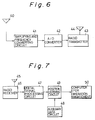
- Fig. 6 is a block diagram showing a mobile-station device according to another embodiment of the present invention.
- the mobile-station device is provided with an antenna 40, an amplifying and frequency converting circuit 41, an analog-to-digital (A/D) converter 42, and a radio transmitter 43.
- the antenna 40 is used for receiving a GPS signal transmitted from the GPS satellite.
- the circuit 41 contains a pre-amplifying section for amplifying the received GPS signal.
- the circuit 41 serves to convert the amplified GPS signal into an IF signal.
- the A/D converter 42 serves to convert the IF signal into a digital.
- the radio transmitter 43 serves to transmit the digital signal to the base station through the antenna 44.
- a local oscillating signal is applied to the circuit 41.
- the local signal is synthesized in an oscillator (not shown).
- Fig. 7 is a block diagram showing the base-station device according to this embodiment.
- the base-station device is provided with an antenna 45, a radio receiver 46, a digital signal processing circuit 47, a position deriving circuit 49, and a personal computer 50.
- the radio receiver 46 serves to receive the data transmitted from the mobile station through the antenna 45.
- the digital signal processing circuit 47 operates to sense a synchronous phase about each GPS satellite and derive a pseudo-distance from each GPS satellite.
- the position deriving circuit 49 serves to derive the measuring data based on the derived pseudo-distance and the data about the position of each GPS satellite given by an auxiliary data circuit 48.
- the personal computer 50 manages the operation of the mobile station based on the measuring data and the measured time.
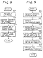
- Figs. 8 and 9 are flowcharts showing a flow of data done in the mobile station and the base station according to the embodiment of the present invention, respectively.
- the program shown in Fig. 8 is executed at a given interval so that the data is transmitted to the base station.
- a digital signal on the carrier level and the time mark is transmitted by the radio transmitter 43 without being processed.
- the time mark stands for when the signal is collected from the GPS satellite.
- the radio transmitter 43 may be a mobile phone or another radio means. In a taxi, for example, a taxi radio may be used for simplifying the overall arrangement.
- the program shown in Fig. 9 is executed on the base station.
- the base station receives the foregoing data transmitted from the mobile station. Then, the processes at the steps S32 to S36 are executed.
- the processes at the step S32 to S36 are the same as those at the steps S12 to S16 of Fig. 5.
- the GPS position measuring system does not need to provide a numerical control oscillator, a digital signal processor, a 16-bit central processing unit and a numerical processor.
- the mobile station is made small-sized, lightweight and less costly.
- this system is capable of grasping the position of the mobile station in an online manner so that the taxis, for example, are allowed to be efficiently operated. By returning the position of each mobile station from the base station to the mobile station by radio, each mobile station enables to know its position or the position of another mobile station.
- the present invention may apply to management of operations of the cars.
- the present invention may apply to management of various mobiles such as management of mount climbers and flight orbits of a hung glider, for example.
- the means for transferring the digital signal to the base station may be a memory card, an IC card, another type of semiconductor storage means, a magnetic medium such as a magnetic tape and a magnetic disk, and another type of recording medium except the magnetic and semiconductor media.
- the transferring means may be a radio means except a surface radio, an optical means such as a ray of light or a laser beam, or a wire means.
- Fig. 10 is a block diagram schematically showing an arrangement of a GPS receiver according to the embodiment of the present invention.
- the GPS receiver is provided with an antenna 60 through which a GPS signal is received from a GPS satellite, an amplifying and frequency converting circuit 61, an analog-to-digital (A/D) converter 62, a writing circuit 63, a memory 64, a reading circuit 65, a digital signal processing circuit 66, and a position deriving circuit 67.
- the amplifying and frequency converting circuit 61 has a pre-amplifying section for amplifying the received GPS signal and converts the amplified signal into an IF (intermediate frequency) signal.
- the IF signal is sent to the A/D converter 62 which serves to convert the IF signal into a digital signal.
- the writing circuit 63 serves to write the digital signal extending for a certain period of time, for example, 30 seconds (corresponding to about one page (one main frame)) into the memory 64 such as an IC memory.
- the reading circuit 65 serves to read the written digital signal from the memory 64.
- the digital signal processing circuit 66 operates to perform the reverse diffusion of the written digital signal by using a diffusion code for each GPS satellite located within a receivable field for the purpose of demodulating the data from the signal.
- the demodulated data contains ephemerides (data about a satellite orbit) of all the satellites and a pseudo-distance from each of all the satellite.
- the position deriving circuit 67 serves to derive the position of a GPS receiver itself from the derived pseudo-distance and the data about a satellite orbit. Though not shown, a local oscillating signal is applied to the circuit 61. The local oscillating signal is synthesized in an oscillator (not shown).
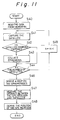
- Fig. 11 is flowcharts showing a flow of data process done in this embodiment.
- the signal is received from each GPS satellite located within the signal-receivable field through the antenna 60.
- the RF (radio frequency) signal is converted down to the IF signal.
- the IF signal converted in the circuit 61 is a signal obtained by modulating a carrier in a BPSK (Bi-Phase Shift Keying) system.
- the GPS receiver employs the spectrum diffusion communication system in which the GPS signals sent from the GPS satellites are located on the band in an overlapping manner.
- the IF signal composed of all the overlapped signals is sampled and quantized in the A/D converter 62 for obtaining a digital signal at the step S3.
- the reading circuit 63 serves to write a digital signal to the memory 64 for a certain period of time, for example, 30 seconds (corresponding to about one page).
- the reading circuit 65 serves to read the digital signal from the memory 64.
- a diffusion code for one of all the GPS satellites located within a receivable field is multiplied by the read digital data.
- the reverse diffusion is carried out with respect to the multiplied result for sensing the synchronous phase of the satellite (capturing the satellite).
- it is determined whether or not the satellite is properly captured In case of yes, at a step S43, the ephemeris (data about a satellite orbit) of this satellite is collected from the data for one page. Then, the process goes to a step S44. In case that the satellite is not properly captured, the process skips the step S43 and goes to a step S44.
- step S44 it is determined how many times the process from the steps S41 to S43 is carried out and whether or not the time K (for example, 8) is more than the number of all the GPS satellites. If the time K is not more than the number of all the GPS satellites, at a step S45, K is incremented by one and then the process at the steps S41 to S43 is repeated.
- the time K for example, 8
- step S46 the process goes to a step S46.
- the GDOP is derived from those ephemerides.
- the four satellites are selected so that a measuring error may become minimum.
- a step S47 each pseudo-distance between a GPS receiver and each of the selected four satellites is derived on the basis of the data about each satellite.
- the processes done at the steps S41 to S47 are carried out in the digital signal processing circuit 66.
- the position deriving circuit 67 serves to operate the position of the GPS receiver based on the derived pseudo-distance and the ephemerides (data about satellite orbits).
- this embodiment is arranged to process the data on time series in a digital signal processing circuit for one channel.
- the function of the multi-channel digital processing circuit can be achieved by one-channel hardware.
- the time needed in keeping the antenna directed toward the sky corresponds to one page of the GPS signal, that is, about 30 seconds.
- the time needed in supporting the GPS receiver is greatly reduced to a quite short time, resulting in greatly reducing the burden of the user.
- the data stored in the memory 64 such as an IC memory is allowed to be read from the memory 64 at any speed.
- the processing time consumed at the steps S41 to S43 is reduced to 1/n.
- a magnetic medium such as a magnetic tape or a magnetic disk, or a recording medium except the magnetic and semiconductor medium may be used.
- the digital signal processing circuit may provide two or more channels.
Landscapes
- Physics & Mathematics (AREA)
- General Physics & Mathematics (AREA)
- Engineering & Computer Science (AREA)
- Radar, Positioning & Navigation (AREA)
- Remote Sensing (AREA)
- Computer Networks & Wireless Communication (AREA)
- Position Fixing By Use Of Radio Waves (AREA)
Applications Claiming Priority (4)
| Application Number | Priority Date | Filing Date | Title |
|---|---|---|---|
| JP8006391A JPH04315078A (ja) | 1991-04-12 | 1991-04-12 | Gps受信装置 |
| JP80063/91 | 1991-04-12 | ||
| JP3080062A JPH04315077A (ja) | 1991-04-12 | 1991-04-12 | Gps測位システム、該システムの移動局装置、及び基地局装置 |
| JP80062/91 | 1991-04-12 |
Publications (2)
| Publication Number | Publication Date |
|---|---|
| EP0508405A1 true EP0508405A1 (fr) | 1992-10-14 |
| EP0508405B1 EP0508405B1 (fr) | 1997-07-09 |
Family
ID=26421095
Family Applications (1)
| Application Number | Title | Priority Date | Filing Date |
|---|---|---|---|
| EP92106075A Expired - Lifetime EP0508405B1 (fr) | 1991-04-12 | 1992-04-08 | Système de localisation et récepteur GPS |
Country Status (3)
| Country | Link |
|---|---|
| US (1) | US5434787A (fr) |
| EP (1) | EP0508405B1 (fr) |
| DE (1) | DE69220705T2 (fr) |
Cited By (48)
| Publication number | Priority date | Publication date | Assignee | Title |
|---|---|---|---|---|
| EP0617385A2 (fr) * | 1993-03-26 | 1994-09-28 | Nippondenso Co., Ltd. | Système de confirmation d'achèvement des tâches pour véhicules |
| WO1994022112A1 (fr) * | 1993-03-23 | 1994-09-29 | Mannesmann Ag | Installation pour un systeme de calcul de l'utilisation |
| WO1994028514A1 (fr) * | 1993-05-28 | 1994-12-08 | Mannesmann Ag | Procede et dispositif a bord d'un vehicule permettant d'effectuer un debit electronique correspondant a l'utilisation de tronçons a peage |
| WO1994028513A1 (fr) * | 1993-05-28 | 1994-12-08 | Mannesmann Ag | Dispositif place dans un vehicule permettant d'effectuer un debit correspondant a l'utilisation de troncons a peage |
| WO1994028511A1 (fr) * | 1993-05-28 | 1994-12-08 | Mannesmann Ag | Dispositif permettant d'effectuer un debit correspondant a l'utilisation de tronçons a peage |
| WO1994028512A1 (fr) * | 1993-05-28 | 1994-12-08 | Mannesmann Ag | Procede permettant de decompter des taxes correspondant a des prestations de service, au moyen d'une carte a memoire |
| WO1994028510A1 (fr) * | 1993-05-28 | 1994-12-08 | Mannesmann Ag | Dispositif place dans un vehicule permettant d'effectuer un debit correspondant a l'utilisation de tronçons a peage |
| WO1995000895A2 (fr) * | 1993-06-15 | 1995-01-05 | Kapolka Peter | Appareil d'enregistrement automatique de donnees de mesure en fonction de la position geographique |
| WO1995005644A1 (fr) * | 1993-08-14 | 1995-02-23 | Baehring Horst | Installation pour relever la distance parcourue par un vehicule automobile |
| FR2710170A1 (fr) * | 1993-09-13 | 1995-03-24 | Dirler Sa | Système de gestion d'un parc d'engins mobiles. |
| WO1995013594A1 (fr) * | 1993-11-08 | 1995-05-18 | Mannesmann Ag | Systeme d'enregistrement d'informations relatives a un itineraire parcouru par un vehicule |
| EP0674294A1 (fr) * | 1994-03-22 | 1995-09-27 | Schmidt Holding Europe GmbH | Véhicule à moteur avec un dispositif pour enregistrer une route |
| WO1996035196A1 (fr) * | 1995-05-01 | 1996-11-07 | Minnesota Mining And Manufacturing Company | Systeme automatise pour parc de panonceaux |
| WO1997014055A1 (fr) * | 1995-10-09 | 1997-04-17 | Snaptrack, Inc. | Procede et dispositif permettant de determiner la localisation d'un objet pouvant avoir une vue obstruee du ciel |
| ES2109154A1 (es) * | 1995-03-15 | 1998-01-01 | Bravo Bustamante Andres | Procedimiento de localizacion de un telefono movil y equipo para su implementacion. |
| ES2111483A1 (es) * | 1995-11-27 | 1998-03-01 | Ciges Faura Manuel | Sistema de control de vehiculos sobre rutas de transporte. |
| ES2112184A1 (es) * | 1995-10-30 | 1998-03-16 | Molinero Garcia Francisco J | Grabador de datos con posicionaniento gps sobre tarjetas de memoria tipo pcmcia o similar. |
| WO1998034164A1 (fr) * | 1997-02-03 | 1998-08-06 | Snaptrack, Inc. | Procede et dispositif pour mesurer le temps dans un systeme de positionnement par satellites |
| US5831574A (en) * | 1996-03-08 | 1998-11-03 | Snaptrack, Inc. | Method and apparatus for determining the location of an object which may have an obstructed view of the sky |
| WO1999003070A1 (fr) * | 1997-07-08 | 1999-01-21 | Jacques Rivailler | Terminal informatique individuel susceptible de communiquer avec un equipement informatique d'une façon securisee, ainsi qu'un procede d'authentification mis en oeuvre par ledit terminal |
| US5874914A (en) * | 1995-10-09 | 1999-02-23 | Snaptrack, Inc. | GPS receiver utilizing a communication link |
| EP0689169A3 (fr) * | 1994-06-21 | 1999-06-02 | Fujitsu Limited | Système de réglage de péage automatique et élément de stockage avec un fonction de communication par radio, appareils associés de conversion de fréquence, d'écriture, de réglement, de dépÔt et d'interrogation |
| WO1999042969A1 (fr) * | 1998-02-23 | 1999-08-26 | Svenerik Sahlin | Procede pour prevenir le vol et la fraude dans les transports |
| WO1999057576A1 (fr) * | 1998-05-04 | 1999-11-11 | Snaptrack, Inc. | Procede et dispositif d'utilisation d'un recepteur de systeme a positionnement par satellite |
| WO2000060546A1 (fr) * | 1999-04-01 | 2000-10-12 | Siemens Aktiengesellschaft | Procede et dispositif s'utilisant notamment pour la saisie mobile de donnees |
| CN1069014C (zh) * | 1994-11-21 | 2001-07-25 | 明星电气株式会社 | 时分多址型无线电电话系统、用于该系统的天线装置和基站 |
| US6377209B1 (en) | 1997-02-03 | 2002-04-23 | Snaptrack, Inc. | Method and apparatus for satellite positioning system (SPS) time measurement |
| US6400314B1 (en) | 1995-10-09 | 2002-06-04 | Qualcomm Incorporated | GPS receiver utilizing a communication link |
| US6421002B2 (en) | 1995-10-09 | 2002-07-16 | Snaptrack, Inc. | GPS receiver utilizing a communication link |
| US6433731B1 (en) | 1997-02-03 | 2002-08-13 | Snaptrack, Inc. | Method and apparatus for determining time in a satellite positioning system |
| WO2004059337A1 (fr) | 2002-12-24 | 2004-07-15 | Koninklijke Philips Electronics N.V. | Recepteur gps a transmission de donnees chiffrees |
| WO2014193221A1 (fr) | 2013-05-29 | 2014-12-04 | Folkers Willem | Procédé et système permettant de récupérer des données de localisation d'un objet au cours du temps au moyen d'un récepteur gnss à des fins d'anti-mystification, et récepteur et lecteur de signaux dans l'espace pour ce procédé et ce système |
| WO2015191862A1 (fr) * | 2014-06-13 | 2015-12-17 | Trimble Navigation Limited | Système de récepteur de système mondial de navigation par satellite basé sur un véhicule et équipé d'un composant matériel à fréquence radio |
| US9369843B2 (en) | 2012-12-28 | 2016-06-14 | Trimble Navigation Limited | Extracting pseudorange information using a cellular device |
| US9429640B2 (en) | 2012-12-28 | 2016-08-30 | Trimble Navigation Limited | Obtaining pseudorange information using a cellular device |
| US9612341B2 (en) | 2012-12-28 | 2017-04-04 | Trimble Inc. | GNSS receiver positioning system |
| US9639941B2 (en) | 2012-12-28 | 2017-05-02 | Trimble Inc. | Scene documentation |
| US9645248B2 (en) | 2012-12-28 | 2017-05-09 | Trimble Inc. | Vehicle-based global navigation satellite system receiver system with radio frequency hardware component |
| US9743373B2 (en) | 2012-12-28 | 2017-08-22 | Trimble Inc. | Concurrent dual processing of pseudoranges with corrections |
| US9821999B2 (en) | 2012-12-28 | 2017-11-21 | Trimble Inc. | External GNSS receiver module with motion sensor suite for contextual inference of user activity |
| US9835729B2 (en) | 2012-12-28 | 2017-12-05 | Trimble Inc. | Global navigation satellite system receiver system with radio frequency hardware component |
| US9880286B2 (en) | 2012-12-28 | 2018-01-30 | Trimble Inc. | Locally measured movement smoothing of position fixes based on extracted pseudoranges |
| US9903957B2 (en) | 2012-12-28 | 2018-02-27 | Trimble Inc. | Global navigation satellite system receiver system with radio frequency hardware component |
| US9910158B2 (en) | 2012-12-28 | 2018-03-06 | Trimble Inc. | Position determination of a cellular device using carrier phase smoothing |
| US9923626B2 (en) | 2014-06-13 | 2018-03-20 | Trimble Inc. | Mobile ionospheric data capture system |
| US9945959B2 (en) | 2012-12-28 | 2018-04-17 | Trimble Inc. | Global navigation satellite system receiver system with radio frequency hardware component |
| US10101465B2 (en) | 2012-12-28 | 2018-10-16 | Trimble Inc. | Electronic tape measure on a cellphone |
| USD864927S1 (en) | 2015-05-14 | 2019-10-29 | Trimble Inc. | Navigation satellite system antenna mount |
Families Citing this family (54)
| Publication number | Priority date | Publication date | Assignee | Title |
|---|---|---|---|---|
| US8352400B2 (en) | 1991-12-23 | 2013-01-08 | Hoffberg Steven M | Adaptive pattern recognition based controller apparatus and method and human-factored interface therefore |
| US10361802B1 (en) | 1999-02-01 | 2019-07-23 | Blanding Hovenweep, Llc | Adaptive pattern recognition based control system and method |
| US7064749B1 (en) | 1992-11-09 | 2006-06-20 | Adc Technology Inc. | Portable communicator |
| US5861841A (en) * | 1992-11-18 | 1999-01-19 | Trimble Navigation Limited | Compact GPS receiver/processor |
| US5983161A (en) | 1993-08-11 | 1999-11-09 | Lemelson; Jerome H. | GPS vehicle collision avoidance warning and control system and method |
| US20040113794A1 (en) * | 1994-10-27 | 2004-06-17 | Dan Schlager | Self-locating personal alarm system equipped parachute |
| GB2301725B (en) | 1995-05-31 | 2000-02-02 | Gen Electric | A reduced-power GPS-based system for tracking multiple objects from a central location |
| US5832187A (en) | 1995-11-03 | 1998-11-03 | Lemelson Medical, Education & Research Foundation, L.P. | Fire detection systems and methods |
| US6057800A (en) * | 1996-06-28 | 2000-05-02 | State University Of New York | RDOP surface for GPS relative positioning |
| US5919239A (en) * | 1996-06-28 | 1999-07-06 | Fraker; William F. | Position and time-at-position logging system |
| US5801659A (en) * | 1996-12-17 | 1998-09-01 | Dytech Limited Inc. | Apparatus and method for coupling satellite navigation signals to a VOR system |
| US6084510A (en) | 1997-04-18 | 2000-07-04 | Lemelson; Jerome H. | Danger warning and emergency response system and method |
| US6459704B1 (en) * | 1997-08-12 | 2002-10-01 | Spectrum Tracking Systems, Inc. | Method and system for radio-location determination |
| US6029121A (en) * | 1997-08-22 | 2000-02-22 | Stashko; Stephen O. | Golf pin distance measuring system |
| US7268700B1 (en) | 1998-01-27 | 2007-09-11 | Hoffberg Steven M | Mobile communication device |
| US6236359B1 (en) | 1998-05-14 | 2001-05-22 | Nortel Networks Limited | Cellular terminal location using GPS signals in the cellular band |
| US6249245B1 (en) | 1998-05-14 | 2001-06-19 | Nortel Networks Limited | GPS and cellular system interworking |
| US5982324A (en) * | 1998-05-14 | 1999-11-09 | Nortel Networks Corporation | Combining GPS with TOA/TDOA of cellular signals to locate terminal |
| US6054928A (en) | 1998-06-04 | 2000-04-25 | Lemelson Jerome H. | Prisoner tracking and warning system and corresponding methods |
| US6690978B1 (en) * | 1998-07-08 | 2004-02-10 | Jerry Kirsch | GPS signal driven sensor positioning system |
| US6028514A (en) * | 1998-10-30 | 2000-02-22 | Lemelson Jerome H. | Personal emergency, safety warning system and method |
| US7904187B2 (en) | 1999-02-01 | 2011-03-08 | Hoffberg Steven M | Internet appliance system and method |
| US6411892B1 (en) * | 2000-07-13 | 2002-06-25 | Global Locate, Inc. | Method and apparatus for locating mobile receivers using a wide area reference network for propagating ephemeris |
| US6285320B1 (en) | 1999-09-03 | 2001-09-04 | Sikorsky Aircraft Corporation | Apparatus and method for mapping surfaces of an object |
| US7588180B1 (en) * | 2000-01-28 | 2009-09-15 | International Apparel Group, Llc | Multi-application smart card with currency exchange, location tracking, and personal identification capabilities |
| JP3624826B2 (ja) * | 2000-12-20 | 2005-03-02 | 日本電気株式会社 | Gps受信装置及びgps測位システム |
| AUPS123702A0 (en) * | 2002-03-22 | 2002-04-18 | Nahla, Ibrahim S. Mr | The train navigtion and control system (TNCS) for multiple tracks |
| EP1353260B1 (fr) * | 2002-04-12 | 2006-05-31 | Matsushita Electric Industrial Co., Ltd. | Système et méthode de stockage d'informations de positionnement, memoire semi-conducteur, et programme |
| US6681181B2 (en) * | 2002-05-20 | 2004-01-20 | Sige Semiconductor Inc. | GPS receiver with improved immunity to burst transmissions |
| KR100429516B1 (ko) * | 2002-05-24 | 2004-05-03 | 삼성전자주식회사 | 인쇄 회로 기판의 하우징 |
| JP2004028655A (ja) * | 2002-06-24 | 2004-01-29 | Sony Corp | 測位計算方法および測位用受信機 |
| US20040059504A1 (en) * | 2002-09-20 | 2004-03-25 | Gray Christopher R. | Method and apparatus to automatically prevent aircraft collisions |
| US9818136B1 (en) | 2003-02-05 | 2017-11-14 | Steven M. Hoffberg | System and method for determining contingent relevance |
| GB0418357D0 (en) * | 2004-08-18 | 2004-09-22 | Koninkl Philips Electronics Nv | Gps receiver and related method and apparatus |
| KR100687195B1 (ko) * | 2004-12-02 | 2007-02-27 | 엘지전자 주식회사 | 교통카드를 구비한 이동통신 단말기의 지도정보 이용장치및 그 방법 |
| US7692580B2 (en) * | 2005-09-06 | 2010-04-06 | Reagan Inventions, Llc | Device, system and method for controlling and storing sensitive information on a GPS device |
| US7761072B2 (en) * | 2005-12-14 | 2010-07-20 | Sige Semiconductor (Europe) Limited | GPS receiver with improved immunity to burst transmissions |
| US7778775B2 (en) * | 2006-05-16 | 2010-08-17 | Casio Computer Co., Ltd. | Position detecting apparatus and method of detecting a position |
| US7589671B2 (en) * | 2006-08-25 | 2009-09-15 | Trimble Navigation Limited | GPS node locator using an intermediate node location for determining location of a remote node |
| US20080068262A1 (en) * | 2006-08-25 | 2008-03-20 | Peter Van Wyck Loomis | Remote node providing GPS signal samples for GPS positioning over a communication network |
| EP2118870B1 (fr) * | 2006-12-04 | 2016-03-02 | Telit Automotive Solutions NV | Enregistreur de données pour véhicule |
| US7551126B2 (en) * | 2007-03-08 | 2009-06-23 | Trimble Navigation Limited | GNSS sample processor for determining the location of an event |
| US7719467B2 (en) * | 2007-03-08 | 2010-05-18 | Trimble Navigation Limited | Digital camera with GNSS picture location determination |
| US9164176B2 (en) * | 2007-06-01 | 2015-10-20 | Novatel, Inc. | GNSS receiver and antenna system including a digital communication subsystem |
| US8169999B2 (en) | 2009-01-16 | 2012-05-01 | Broadcom Corporation | Method and system for preserving content timing across femtocell interfaces via timestamp insertion |
| US8305955B2 (en) | 2009-02-27 | 2012-11-06 | Broadcom Corporation | Method and system for network synchronization via a femtocell |
| RU2484494C1 (ru) * | 2011-11-07 | 2013-06-10 | Федеральное государственное бюджетное образовательное учреждение высшего профессионального образования "Мурманский государственный технический университет" (ФГБОУВПО "МГТУ") | Способ определения местоположения объекта |
| US9462446B2 (en) | 2012-12-28 | 2016-10-04 | Trimble Navigation Limited | Collecting external accessory data at a mobile data collection platform that obtains raw observables from an internal chipset |
| US9488736B2 (en) | 2012-12-28 | 2016-11-08 | Trimble Navigation Limited | Locally measured movement smoothing of GNSS position fixes |
| US9467814B2 (en) | 2012-12-28 | 2016-10-11 | Trimble Navigation Limited | Collecting external accessory data at a mobile data collection platform that obtains raw observables from an external GNSS raw observable provider |
| US9456067B2 (en) | 2012-12-28 | 2016-09-27 | Trimble Navigation Limited | External electronic distance measurement accessory for a mobile data collection platform |
| US9544737B2 (en) | 2012-12-28 | 2017-01-10 | Trimble Inc. | Performing data collection based on external raw observables using a mobile data collection platform |
| US9538336B2 (en) | 2012-12-28 | 2017-01-03 | Trimble Inc. | Performing data collection based on internal raw observables using a mobile data collection platform |
| US11614545B2 (en) | 2020-03-26 | 2023-03-28 | Novatel Inc. | Systems and methods for utilizing a connector with an external antenna to utilize multifrequency GNSS functionality of a mobile device |
Citations (2)
| Publication number | Priority date | Publication date | Assignee | Title |
|---|---|---|---|---|
| EP0155776A1 (fr) * | 1984-03-01 | 1985-09-25 | Stc Plc | Récepteur numérique pour NAVSTAR |
| GB2241623A (en) * | 1990-02-28 | 1991-09-04 | Philips Electronic Associated | Vehicle location system |
Family Cites Families (5)
| Publication number | Priority date | Publication date | Assignee | Title |
|---|---|---|---|---|
| US4578678A (en) * | 1983-11-14 | 1986-03-25 | The United States Of America As Represented By The United States National Aeronautics And Space Administration | High dynamic global positioning system receiver |
| JPH0221093A (ja) * | 1988-07-11 | 1990-01-24 | Toyo Tire & Rubber Co Ltd | 自己成形性ホース |
| US5155490A (en) * | 1990-10-15 | 1992-10-13 | Gps Technology Corp. | Geodetic surveying system using multiple GPS base stations |
| US5148452A (en) * | 1990-12-31 | 1992-09-15 | Motorola, Inc. | Global positioning system digital receiver |
| US5365450A (en) * | 1992-12-17 | 1994-11-15 | Stanford Telecommunications, Inc. | Hybrid GPS/data line unit for rapid, precise, and robust position determination |
-
1992
- 1992-04-08 US US07/866,021 patent/US5434787A/en not_active Expired - Lifetime
- 1992-04-08 EP EP92106075A patent/EP0508405B1/fr not_active Expired - Lifetime
- 1992-04-08 DE DE69220705T patent/DE69220705T2/de not_active Expired - Fee Related
Patent Citations (2)
| Publication number | Priority date | Publication date | Assignee | Title |
|---|---|---|---|---|
| EP0155776A1 (fr) * | 1984-03-01 | 1985-09-25 | Stc Plc | Récepteur numérique pour NAVSTAR |
| GB2241623A (en) * | 1990-02-28 | 1991-09-04 | Philips Electronic Associated | Vehicle location system |
Cited By (67)
| Publication number | Priority date | Publication date | Assignee | Title |
|---|---|---|---|---|
| WO1994022112A1 (fr) * | 1993-03-23 | 1994-09-29 | Mannesmann Ag | Installation pour un systeme de calcul de l'utilisation |
| EP0752688A2 (fr) * | 1993-03-23 | 1997-01-08 | MANNESMANN Aktiengesellschaft | Dispositif pour identifier les distances routières |
| AU676282B2 (en) * | 1993-03-23 | 1997-03-06 | Kapsch Trafficcom Ag | Charging system |
| EP0752688A3 (fr) * | 1993-03-23 | 1997-12-10 | MANNESMANN Aktiengesellschaft | Dispositif pour identifier les distances routières |
| EP0617385A2 (fr) * | 1993-03-26 | 1994-09-28 | Nippondenso Co., Ltd. | Système de confirmation d'achèvement des tâches pour véhicules |
| EP0617385A3 (fr) * | 1993-03-26 | 1996-02-07 | Nippon Denso Co | Système de confirmation d'achèvement des tâches pour véhicules. |
| WO1994028514A1 (fr) * | 1993-05-28 | 1994-12-08 | Mannesmann Ag | Procede et dispositif a bord d'un vehicule permettant d'effectuer un debit electronique correspondant a l'utilisation de tronçons a peage |
| WO1994028513A1 (fr) * | 1993-05-28 | 1994-12-08 | Mannesmann Ag | Dispositif place dans un vehicule permettant d'effectuer un debit correspondant a l'utilisation de troncons a peage |
| WO1994028511A1 (fr) * | 1993-05-28 | 1994-12-08 | Mannesmann Ag | Dispositif permettant d'effectuer un debit correspondant a l'utilisation de tronçons a peage |
| WO1994028512A1 (fr) * | 1993-05-28 | 1994-12-08 | Mannesmann Ag | Procede permettant de decompter des taxes correspondant a des prestations de service, au moyen d'une carte a memoire |
| WO1994028510A1 (fr) * | 1993-05-28 | 1994-12-08 | Mannesmann Ag | Dispositif place dans un vehicule permettant d'effectuer un debit correspondant a l'utilisation de tronçons a peage |
| WO1995000895A2 (fr) * | 1993-06-15 | 1995-01-05 | Kapolka Peter | Appareil d'enregistrement automatique de donnees de mesure en fonction de la position geographique |
| WO1995000895A3 (fr) * | 1993-06-15 | 1995-02-23 | Peter Kapolka | Appareil d'enregistrement automatique de donnees de mesure en fonction de la position geographique |
| WO1995005644A1 (fr) * | 1993-08-14 | 1995-02-23 | Baehring Horst | Installation pour relever la distance parcourue par un vehicule automobile |
| FR2710170A1 (fr) * | 1993-09-13 | 1995-03-24 | Dirler Sa | Système de gestion d'un parc d'engins mobiles. |
| WO1995013594A1 (fr) * | 1993-11-08 | 1995-05-18 | Mannesmann Ag | Systeme d'enregistrement d'informations relatives a un itineraire parcouru par un vehicule |
| US6141609A (en) * | 1993-11-08 | 2000-10-31 | Mannesmann Aktiengesellschaft | Device for recording information on a vehicle's itinerary |
| EP0674294A1 (fr) * | 1994-03-22 | 1995-09-27 | Schmidt Holding Europe GmbH | Véhicule à moteur avec un dispositif pour enregistrer une route |
| US6088680A (en) * | 1994-06-21 | 2000-07-11 | Fujitsu Limited | Automatic toll adjusting system, and storage medium with a radio communication function, frequency converting apparatus, writing apparatus, settling apparatus, depositing apparatus and inquiring apparatus therefor |
| EP0689169A3 (fr) * | 1994-06-21 | 1999-06-02 | Fujitsu Limited | Système de réglage de péage automatique et élément de stockage avec un fonction de communication par radio, appareils associés de conversion de fréquence, d'écriture, de réglement, de dépÔt et d'interrogation |
| CN1069014C (zh) * | 1994-11-21 | 2001-07-25 | 明星电气株式会社 | 时分多址型无线电电话系统、用于该系统的天线装置和基站 |
| ES2109154A1 (es) * | 1995-03-15 | 1998-01-01 | Bravo Bustamante Andres | Procedimiento de localizacion de un telefono movil y equipo para su implementacion. |
| WO1996035196A1 (fr) * | 1995-05-01 | 1996-11-07 | Minnesota Mining And Manufacturing Company | Systeme automatise pour parc de panonceaux |
| US6400314B1 (en) | 1995-10-09 | 2002-06-04 | Qualcomm Incorporated | GPS receiver utilizing a communication link |
| US6421002B2 (en) | 1995-10-09 | 2002-07-16 | Snaptrack, Inc. | GPS receiver utilizing a communication link |
| US5874914A (en) * | 1995-10-09 | 1999-02-23 | Snaptrack, Inc. | GPS receiver utilizing a communication link |
| WO1997014055A1 (fr) * | 1995-10-09 | 1997-04-17 | Snaptrack, Inc. | Procede et dispositif permettant de determiner la localisation d'un objet pouvant avoir une vue obstruee du ciel |
| US6133871A (en) * | 1995-10-09 | 2000-10-17 | Snaptrack, Inc. | GPS receiver having power management |
| US6016119A (en) * | 1995-10-09 | 2000-01-18 | Snaptrack, Inc. | Method and apparatus for determining the location of an object which may have an obstructed view of the sky |
| ES2112184A1 (es) * | 1995-10-30 | 1998-03-16 | Molinero Garcia Francisco J | Grabador de datos con posicionaniento gps sobre tarjetas de memoria tipo pcmcia o similar. |
| ES2111483A1 (es) * | 1995-11-27 | 1998-03-01 | Ciges Faura Manuel | Sistema de control de vehiculos sobre rutas de transporte. |
| US5831574A (en) * | 1996-03-08 | 1998-11-03 | Snaptrack, Inc. | Method and apparatus for determining the location of an object which may have an obstructed view of the sky |
| US6052081A (en) * | 1997-02-03 | 2000-04-18 | Snaptrack, Inc. | Method and apparatus for satellite positioning system based time measurement |
| US6839021B2 (en) | 1997-02-03 | 2005-01-04 | Qualcomm Incorporated | Method and apparatus for determining time in a satellite positioning system |
| US6597311B2 (en) | 1997-02-03 | 2003-07-22 | Snaptrack, Inc. | Method and apparatus for determining time in a satellite positioning system |
| US6239742B1 (en) | 1997-02-03 | 2001-05-29 | Snaptrack, Inc. | Method and apparatus for satellite positioning system based time measurement |
| US6377209B1 (en) | 1997-02-03 | 2002-04-23 | Snaptrack, Inc. | Method and apparatus for satellite positioning system (SPS) time measurement |
| WO1998034164A1 (fr) * | 1997-02-03 | 1998-08-06 | Snaptrack, Inc. | Procede et dispositif pour mesurer le temps dans un systeme de positionnement par satellites |
| US6583757B2 (en) | 1997-02-03 | 2003-06-24 | Snaptrack, Inc. | Method and apparatus for satellite positioning system (SPS) time measurement |
| US6433731B1 (en) | 1997-02-03 | 2002-08-13 | Snaptrack, Inc. | Method and apparatus for determining time in a satellite positioning system |
| WO1999003070A1 (fr) * | 1997-07-08 | 1999-01-21 | Jacques Rivailler | Terminal informatique individuel susceptible de communiquer avec un equipement informatique d'une façon securisee, ainsi qu'un procede d'authentification mis en oeuvre par ledit terminal |
| WO1999042969A1 (fr) * | 1998-02-23 | 1999-08-26 | Svenerik Sahlin | Procede pour prevenir le vol et la fraude dans les transports |
| US6104338A (en) * | 1998-05-04 | 2000-08-15 | Snaptrack, Inc. | Method and apparatus for operating a satellite positioning system receiver |
| WO1999057576A1 (fr) * | 1998-05-04 | 1999-11-11 | Snaptrack, Inc. | Procede et dispositif d'utilisation d'un recepteur de systeme a positionnement par satellite |
| EP1873549A1 (fr) * | 1998-05-04 | 2008-01-02 | Snaptrack Incorporated | Procédé et appareil pour la commande d'un récepteur de système de positionnement par satellite |
| WO2000060546A1 (fr) * | 1999-04-01 | 2000-10-12 | Siemens Aktiengesellschaft | Procede et dispositif s'utilisant notamment pour la saisie mobile de donnees |
| WO2004059337A1 (fr) | 2002-12-24 | 2004-07-15 | Koninklijke Philips Electronics N.V. | Recepteur gps a transmission de donnees chiffrees |
| US7233282B2 (en) | 2002-12-24 | 2007-06-19 | Nxp B.V. | GPS receiver with encrypted data transmission |
| US9903957B2 (en) | 2012-12-28 | 2018-02-27 | Trimble Inc. | Global navigation satellite system receiver system with radio frequency hardware component |
| US9821999B2 (en) | 2012-12-28 | 2017-11-21 | Trimble Inc. | External GNSS receiver module with motion sensor suite for contextual inference of user activity |
| US10101465B2 (en) | 2012-12-28 | 2018-10-16 | Trimble Inc. | Electronic tape measure on a cellphone |
| US9369843B2 (en) | 2012-12-28 | 2016-06-14 | Trimble Navigation Limited | Extracting pseudorange information using a cellular device |
| US9429640B2 (en) | 2012-12-28 | 2016-08-30 | Trimble Navigation Limited | Obtaining pseudorange information using a cellular device |
| US9612341B2 (en) | 2012-12-28 | 2017-04-04 | Trimble Inc. | GNSS receiver positioning system |
| US9639941B2 (en) | 2012-12-28 | 2017-05-02 | Trimble Inc. | Scene documentation |
| US9645248B2 (en) | 2012-12-28 | 2017-05-09 | Trimble Inc. | Vehicle-based global navigation satellite system receiver system with radio frequency hardware component |
| US9743373B2 (en) | 2012-12-28 | 2017-08-22 | Trimble Inc. | Concurrent dual processing of pseudoranges with corrections |
| US9945959B2 (en) | 2012-12-28 | 2018-04-17 | Trimble Inc. | Global navigation satellite system receiver system with radio frequency hardware component |
| US9835729B2 (en) | 2012-12-28 | 2017-12-05 | Trimble Inc. | Global navigation satellite system receiver system with radio frequency hardware component |
| US9851448B2 (en) | 2012-12-28 | 2017-12-26 | Trimble Inc. | Obtaining pseudorange information using a cellular device |
| US9880286B2 (en) | 2012-12-28 | 2018-01-30 | Trimble Inc. | Locally measured movement smoothing of position fixes based on extracted pseudoranges |
| US9910158B2 (en) | 2012-12-28 | 2018-03-06 | Trimble Inc. | Position determination of a cellular device using carrier phase smoothing |
| WO2014193221A1 (fr) | 2013-05-29 | 2014-12-04 | Folkers Willem | Procédé et système permettant de récupérer des données de localisation d'un objet au cours du temps au moyen d'un récepteur gnss à des fins d'anti-mystification, et récepteur et lecteur de signaux dans l'espace pour ce procédé et ce système |
| NL2013831A (en) * | 2013-05-29 | 2015-01-13 | Willem Folkers | Method for reducing a risk of tampering and/or spoofing of location data of an object over time. |
| US9923626B2 (en) | 2014-06-13 | 2018-03-20 | Trimble Inc. | Mobile ionospheric data capture system |
| WO2015191862A1 (fr) * | 2014-06-13 | 2015-12-17 | Trimble Navigation Limited | Système de récepteur de système mondial de navigation par satellite basé sur un véhicule et équipé d'un composant matériel à fréquence radio |
| USD864927S1 (en) | 2015-05-14 | 2019-10-29 | Trimble Inc. | Navigation satellite system antenna mount |
Also Published As
| Publication number | Publication date |
|---|---|
| EP0508405B1 (fr) | 1997-07-09 |
| US5434787A (en) | 1995-07-18 |
| DE69220705T2 (de) | 1998-01-22 |
| DE69220705D1 (de) | 1997-08-14 |
Similar Documents
| Publication | Publication Date | Title |
|---|---|---|
| US5434787A (en) | System for measuring position by using global positioning system and receiver for global position system | |
| USRE35498E (en) | Vehicle location system | |
| US6298229B1 (en) | GPS receiver for emergency location reporting during intermittent shadowing | |
| JP3240393B2 (ja) | 世界測位システム用トラッキングシステム | |
| US6346911B1 (en) | Method and apparatus for determining time in a GPS receiver | |
| JP5128732B2 (ja) | 衛星位置決めシステム信号を得る方法および装置 | |
| JP5015615B2 (ja) | Gps受信機用の時間を決定するための方法および装置 | |
| US7719467B2 (en) | Digital camera with GNSS picture location determination | |
| US7551126B2 (en) | GNSS sample processor for determining the location of an event | |
| US7239272B2 (en) | Partial almanac collection system | |
| US20100253578A1 (en) | Navigation data acquisition and signal post-processing | |
| KR100787844B1 (ko) | 위성 위치 확인 시스템에 관련된 보조 데이터를 이용하는방법 및 장치 | |
| US8009086B2 (en) | System and method for geo-locating a receiver with reduced power consumption | |
| EP2093584B1 (fr) | Traitement de signaux radio satellite reçus | |
| US20040172195A1 (en) | Method and system for data detection in a global positioning system satellite receiver | |
| US20060208943A1 (en) | Location tagging using post-processing | |
| US6549850B2 (en) | Receiver of a satellite positioning system and associated method | |
| AU2001251085A1 (en) | Determining time in a GPS receiver | |
| JP2011504597A5 (fr) | ||
| CN101828127A (zh) | 卫星定位系统信号的处理 | |
| US7359429B2 (en) | Support of the determination of a correlation | |
| JPH04315077A (ja) | Gps測位システム、該システムの移動局装置、及び基地局装置 | |
| JPH04315078A (ja) | Gps受信装置 | |
| EP1664829A1 (fr) | Systeme de collecte d'ephemerides partiels | |
| JP2010071966A (ja) | Gnss衛星による位置測定方法と装置 |
Legal Events
| Date | Code | Title | Description |
|---|---|---|---|
| PUAI | Public reference made under article 153(3) epc to a published international application that has entered the european phase |
Free format text: ORIGINAL CODE: 0009012 |
|
| AK | Designated contracting states |
Kind code of ref document: A1 Designated state(s): DE FR GB |
|
| 17P | Request for examination filed |
Effective date: 19930112 |
|
| 17Q | First examination report despatched |
Effective date: 19941205 |
|
| GRAG | Despatch of communication of intention to grant |
Free format text: ORIGINAL CODE: EPIDOS AGRA |
|
| GRAH | Despatch of communication of intention to grant a patent |
Free format text: ORIGINAL CODE: EPIDOS IGRA |
|
| GRAH | Despatch of communication of intention to grant a patent |
Free format text: ORIGINAL CODE: EPIDOS IGRA |
|
| GRAA | (expected) grant |
Free format text: ORIGINAL CODE: 0009210 |
|
| AK | Designated contracting states |
Kind code of ref document: B1 Designated state(s): DE FR GB |
|
| REF | Corresponds to: |
Ref document number: 69220705 Country of ref document: DE Date of ref document: 19970814 |
|
| ET | Fr: translation filed | ||
| PLBE | No opposition filed within time limit |
Free format text: ORIGINAL CODE: 0009261 |
|
| STAA | Information on the status of an ep patent application or granted ep patent |
Free format text: STATUS: NO OPPOSITION FILED WITHIN TIME LIMIT |
|
| 26N | No opposition filed | ||
| REG | Reference to a national code |
Ref country code: GB Ref legal event code: IF02 |
|
| PGFP | Annual fee paid to national office [announced via postgrant information from national office to epo] |
Ref country code: FR Payment date: 20090417 Year of fee payment: 18 Ref country code: DE Payment date: 20090402 Year of fee payment: 18 |
|
| PGFP | Annual fee paid to national office [announced via postgrant information from national office to epo] |
Ref country code: GB Payment date: 20090408 Year of fee payment: 18 |
|
| GBPC | Gb: european patent ceased through non-payment of renewal fee |
Effective date: 20100408 |
|
| REG | Reference to a national code |
Ref country code: FR Ref legal event code: ST Effective date: 20101230 |
|
| PG25 | Lapsed in a contracting state [announced via postgrant information from national office to epo] |
Ref country code: DE Free format text: LAPSE BECAUSE OF NON-PAYMENT OF DUE FEES Effective date: 20101103 |
|
| PG25 | Lapsed in a contracting state [announced via postgrant information from national office to epo] |
Ref country code: GB Free format text: LAPSE BECAUSE OF NON-PAYMENT OF DUE FEES Effective date: 20100408 |
|
| PG25 | Lapsed in a contracting state [announced via postgrant information from national office to epo] |
Ref country code: FR Free format text: LAPSE BECAUSE OF NON-PAYMENT OF DUE FEES Effective date: 20100430 |