EP0473152B1 - Topographisches Datenaufbausystem - Google Patents
Topographisches Datenaufbausystem Download PDFInfo
- Publication number
- EP0473152B1 EP0473152B1 EP91114532A EP91114532A EP0473152B1 EP 0473152 B1 EP0473152 B1 EP 0473152B1 EP 91114532 A EP91114532 A EP 91114532A EP 91114532 A EP91114532 A EP 91114532A EP 0473152 B1 EP0473152 B1 EP 0473152B1
- Authority
- EP
- European Patent Office
- Prior art keywords
- data
- topographical
- points
- height
- basis
- Prior art date
- Legal status (The legal status is an assumption and is not a legal conclusion. Google has not performed a legal analysis and makes no representation as to the accuracy of the status listed.)
- Expired - Lifetime
Links
Images


Classifications
-
- G—PHYSICS
- G06—COMPUTING; CALCULATING OR COUNTING
- G06T—IMAGE DATA PROCESSING OR GENERATION, IN GENERAL
- G06T1/00—General purpose image data processing
-
- G—PHYSICS
- G06—COMPUTING; CALCULATING OR COUNTING
- G06T—IMAGE DATA PROCESSING OR GENERATION, IN GENERAL
- G06T17/00—Three dimensional [3D] modelling, e.g. data description of 3D objects
- G06T17/20—Finite element generation, e.g. wire-frame surface description, tesselation
Definitions
- the present invention relates to a topographical data construction system, and more particularly to a topographical data construction system which constructs topographical data representing geographical contours as a coast line, for example.
- the overall configuration is made close to the actual configuration by sequentially inputting actual altitude data by an operator.
- three dimensional topographical data is constructed using fractal technique.
- an object of the present invention is to provide topographical data construction system which is capable of constructing a configuration which provides a natural impression, with an easy operation.
- a topographical data construction system in which altitude data is constructed on the basis of two dimensional topographical data, and three dimensional topographical data is constructed on the basis of the two dimensional topographical data as constructed and the altitude data.
- the topographical data construction system further comprises inputting means for inputting altitude data corresponding to a plurality of optional representative points of a topography which is represented by two dimensional topographical data; division point setting means for setting division points between the adjacent representative points of the plurality of representative points; deviation setting means for setting a deviation on the basis of a distance from the division points to the representative points adjacent to the division points; constructing means for constructing data to indicate the height of the division points using a random number function on the basis of a data representing the height of the adjacent point and the deviation; correcting means for correcting the data to indicate the height of the division points on the basis of data representative of a border between land and sea, wherein the correcting means sets the height data of the division points lying in the sea to the height data of the sea level.
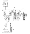
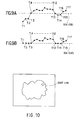
- FIG. 1, 1 generally indicates a stereoscopic topography display system, which includes a topographical surface constructing unit 2 for constructing stereoscopic surfaces representing geographical undulations and a topographical pattern mapping unit 4 for mapping topographical patterns on topographical surfaces constructed by the topographical surface constructing unit 2 and displaying the result on the display unit 3.
- a topographical surface constructing unit 2 for constructing stereoscopic surfaces representing geographical undulations
- a topographical pattern mapping unit 4 for mapping topographical patterns on topographical surfaces constructed by the topographical surface constructing unit 2 and displaying the result on the display unit 3.
- the topographical pattern mapping unit 4 is provided with a picture conversion unit 12 which includes a topographical pattern picture data memory 11.
- a picture conversion unit 12 which includes a topographical pattern picture data memory 11.
- topographical pattern signals SS which have obtained by picking up a map 14 by a television camera 13 are converted by an analog to digital conversion circuit (A/D) 15 to topographical data DS, which is then stored as topographical pattern picture data DT in the topographical pattern picture data memory 11.
- A/D analog to digital conversion circuit
- the topographical data DS consists of map information in which indicia, such as contour lines, rivers and coastlines, drawn on the map 14 are expressed on a two dimensional plane.
- the topographical pattern mapping unit 4 has a topographical pattern database 16, and is capable of storing picture data DP in the topographical pattern database 16, the picture data DP being similar to the topographical pattern picture data DS obtained at the output terminal of the analog to digital conversion circuit (A/D) 15.
- the topographical surface constructing unit 2 has a surface construction unit 21, which constructs height data DH on the basis of two dimensional topographical data D2 stored in a topographical database 22, and stores the height data DH in an altitude database 23.
- the topographical surface constructing unit 2 constructs three dimensional topographical data D3 on the basis of the two dimensional topographical data D2 and height data DH stored in the topographical database 22 and the altitude database 23, respectively.
- Undulations are provided to the topographical data DS stored in the topographical pattern picture data memory 11 based on the three dimensional topographical data D3.
- the topographical surface constructing unit 2 constructs topographical surfaces on the basis of the three dimensional topographical data D3.
- the topographical surface constructing unit 2 stores topographical surface data DVIE in a topographical surface data memory 25, the topographical surface data DVIE being similar to a topographical surface viewed from a visual point indicated by visual point data DSI inputted from a visual point setting data input means 24 consisting of a joystick, for example.
- the topographical surface constructing unit 2 outputs topographical surface data DVIE stored in the topographical surface data memory 25 to the topographical pattern mapping unit 4, where topographical data DS is mapped by applying a technique disclosed in Japanese Patent laid open application No. 58(1983)-19975, for example.
- topographical patterns to be three-dimensionally displayed on the basis of the three dimensional topographical data D3 constructed in the topographical surface constructing unit 2.
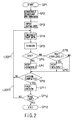
- the topographical surface constructing unit 2 constructs the three dimensional topographical data D3 by executing the routine shown in FIG. 2.
- topographical pattern picture data DT is read in the topographical pattern mapping unit 4
- the topographical surface constructing unit 2 reads in two dimensional topographical data D2 by going from the step SP1 to the step SP2.
- the stereoscopic topography display system 1 constructs a display picture of the map on the display unit 3 on the basis of the topographical pattern picture data DT accepted as well as displays a predetermined cursor on the display picture.
- the topographical surface constructing unit 2 reads in coordinate data of coastline L1 sequentially inputted by moving the cursor, observing the displayed picture, and stores it as two dimensional topographical data D2 in the topographical database 22.
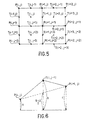
- the topographical surface constructing unit 2 constructs a coastline pattern data and stores it in the topographical database 22, the coastline pattern memory being such that in a two dimensional topography constructed on two dimensional topographical data D2 by the operator's input, the land (which is an area hatched in FIG. 3) and the sea are made discriminable through the coastline L1.
- the height data DH is corrected using the coastline pattern memory every time the height data DH is constructed, and thereby a three dimensional topography similar to the actual topography is formed.
- the topographical surface constructing unit 2 goes to the step SP3, where an initial value of the height data DH is inputted.
- the operator indicates positions of a top PT of a mountain and the like by moving the cursor, eye observing the map displayed on the display unit 3, and thereby inputs the height of the indicated position. This accomplishes the input of the initial value.
- the topographical surface constructing unit 2 reads in the height data DH of several points (hereinafter referred to as representative points as well as coastline) indicated by the operator, and constructs sequentially height data DH referring to the height data DH of the representative points P.
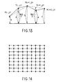
- the topographical surface constructing unit 2 goes to the step SP4, where as shown in FIG. 5, in a two dimensional configuration represented by two dimensional topographical data, an intermediate point T (in this embodiment hereinafter referred to as intermediate point and indicated by x marks) which divides the interval between adjacent representative points P (hereinafter indicated by black circles) is set.
- intermediate point T in this embodiment hereinafter referred to as intermediate point and indicated by x marks
- intermediate point P hereinafter indicated by black circles
- the topographical surface constructing unit 2 sets an intermediate point T(i, j-1) between representative points P(i, j) and P(i+1, j).
- the topographical surface constructing unit 2 goes to the step SP5, where height data DH of the intermediate point T(i, j-1) is constructed.
- altitude data b of generation probability such that the altitude of the largest generation frequency has the average value (a + c)/2 and the standard deviation is k ⁇ 2 -ih with a center of the average value (a + c)/2.
- the i represents the number of repetition of the division, and in this case the i equals 1.
- the k and h represent predetermined coefficients set by the operator.
- the topographical surface constructing unit 2 obtains mean values of height data DH between vertical representative points P(i, j) and P(i, j+1); P(i+1, j) and P(i+1, j+1) in intermediate points T(i-1, j) and T(i+1, j), respectively, and constructs height data DH of generation probability of which standard deviation is k ⁇ 2 -ih with a center of the corresponding mean values.
- the topographical surface constructing unit 2 obtains mean values of height data DH between horizontal representative points P(i, j) and P(i+1, j); P(i, j+1) and P(i+1, j+1) in intermediate points T(i, j-1) and T(i, j+1), respectively, and constructs height data DH of generation probability of which standard deviation is k ⁇ 2 -ih with a center of the corresponding mean values.
- a mean value of the height data DH of the representative points P(i, j), P(i, j+1), P(i+1, j) and P(i+1, j+1) is obtained, and height data DH of generation probability of which standard deviation is k ⁇ 2 -ih with a center of the mean value is constructed.
- deviations are set according to intervals between representative points P, and random number data is constructed on the basis of the deviation with reference to the height data DH of each representative point P.
- the height data DH is constructed based on the random number data.
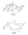
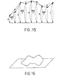
- the construction of the height data DH may be repeated by adding the intermediate points T to the representative points P. This enables two dimensional plane height data DH to be sequentially produced from the coastline and height data DH of the initial value, and hence three dimensional topographical data can be constructed with ease.
- topographical data can be produced by applying fractal technique.
- the height data DH of those areas may be corrected to the height data DH of the sea level (FIG. 9B). This enables the coastline as illustrated in FIG. 10 to be formed, and thus the three dimensional topography can be constructed.
- the height data DH is corrected referring to the coastline pattern memory every time when the height data DH of each intermediate point T is constructed, and thereby three dimensional topographical data which is similar to the actual configuration is constructed.
- the topographical surface constructing unit 2 constructs height data DH of each intermediate point T, it goes to the step SP6 (in FIG. 2), where it is judged by referring to the coastline pattern memory whether or not the intermediate point T is in the sea.
- the topographical surface constructing unit 2 goes to the step SP7, where the height data DH of the intermediate point T which is in the sea is corrected to the height data DH of the sea level 0, and then proceeds to the step SP8.
- the topographical surface constructing unit 2 goes to the step SP9 to judge whether or not the height data DH of the intermediate point T is below the sea level.
- the topographical surface constructing unit 2 goes to the step SP10, where the height data DH of the intermediate point T is corrected to the height data DH of the position lowest in the land, and then goes to the step SP8.
- the step SP8 When on the contrary a negative result is obtained, it directly goes to the step SP8.
- the topographical surface constructing unit 2 corrects the height data DH referring to the coastline pattern memory.
- the topographical surface constructing unit 2 makes a judgement as to whether or not regarding all the adjacent representative points P setting of intermediate points T and construction of the height data DH thereof are completed. When a negative result is obtained, the topographical surface constructing unit 2 returns to the step SP4, where regarding the subsequent representative point P, setting of the intermediate point T and construction of the height data DH are executed.
- loop LOOP 1 consisting of steps SP4, SP5, SP6, SP7, SP8 and SP4, steps SP4, SP5, SP6, SP9, SP10, SP8 and SP4, or steps SP4, SP5, SP6, SP9, SP8 and SP4, setting of intermediate points T between adjacent representative points P is, as described in connection with FIG. 5, sequentially carried out as well as construction of height data DH of the corresponding intermediate points T.
- step SP8 When regarding all the adjacent representative points P, setting of the intermediate points T and construction of height data DH are completed, an affirmative result is obtained in the step SP8, and hence the topographical surface constructing unit 2 goes to the step SP11, where the intermediate point T set is set as representative point P and then, the value i of the equation (1) is increased by 1.
- the topographical surface constructing unit 2 goes to the step SP12, in which it is judged whether or not intervals between the adjacent representative points P are equal to the pixel interval. When there is a representative point P which is away larger than the pixel interval, a negative result is obtained, and thus the topographical surface constructing unit 2 returns to the step SP4.
- the topographical surface constructing unit 2 returns to the step SP4 to repeat the loop LOOP 1, and thereby as shown in FIGS. 12 and 13, an intermediate point T is set between representative points P, and construction of altitude data of an intermediate point T is repeated.
- the topographical surface constructing unit 2 constructs height data DH by generating a random number of the equation (1) after the i is increased by 1, and thereby standard deviation is reset according to the interval between representative points P to produce height data DH.
- the height data DH is corrected, referring to the coastline pattern memory every time the height data DH is constructed, and based on the corrected height data DH, height data DH of the intermediate point T is constructed again.
- height data DH representing a configuration similar to the actual coastline can be constructed, and thereby a three dimensional configuration can be constructed with reality as a whole.
- the topographical surface constructing unit 2 judges whether or not regarding all the adjacent representative points P the resetting of the intermediate point T and the construction of the altitude data DH are completed. When an affirmative result is obtained here, the topographical surface constructing unit 2 goes to the step SP11, where the set intermediate point T is set as the representative point P, and then the i of the equation (1) is increased by 1.
- the topographical surface constructing unit 2 goes to the step SP12, in which it is judged whether or not intervals between the adjacent representative points P are equal to the pixel interval.
- the topographical surface constructing unit 2 returns to the step SP4.
- the height data DH is corrected referring to the coastline pattern memory every time height data DH of the intermediate point T is produced, and thereby height data DH which reflects the features of the actual coastline can be obtained.
- topographical surfaces with a reality can be constructed on the basis of the three dimensional topographical data and the height data DH.
- the topographical surface constructing unit 2 sets the representative points P on the basis of the two dimensional topographical data D2 and the height data DH of the initial value which have been inputted by the operator, and then sequentially sets intermediate points T between the adjacent representative points P as well as constructs height data DH of the intermediate points T.
- the topographical surface constructing unit 2 sets standard deviation according to intervals from the adjacent representative points P, and generates height data DH with a generation probability which has the standard deviation with a center of the mean value of the height data DH of the representative points P.
- the height data DH of the intermediate point T is corrected to height data DH of sea level 0
- the height data DH is corrected to height data DH which represents the lowest position in the land.
- the standard deviation is set according to the interval between the adjacent representative points P, and height data DH is produced with reference to the mean value of the height data DH of the representative points P.
- the height data DH is corrected with reference to the coastline pattern memory.
- the routine is completed by storing the constructed height data DH in the altitude database 23. This enables height data DH to be easily constructed by fractal technique.
- topographical surface which provide a natural impression can be formed by correcting height data DH constructed with reference to the coastline pattern memory.
- three dimensional topographical data D3 can be constructed by adding the height data DH to two dimensional topographical data D2. Configurations which provide a natural impression can be displayed with ease by displaying the topographical pattern picture data DT mapped on topographical surfaces expressed by the three dimensional topographical data D3.
- three dimensional topography which provides a natural impression can be easily formed by correcting constructed height data DH referring to the coastline pattern memory every time the height data DH is constructed by applying fractal technique.
- divisional points are set at intermediate points between adjacent representative points but the present invention is not limited to this.
- two divisional points may be set between adjacent two representative points so that the interval between the representative points is divided into three equal parts, and then altitude data may be constructed for each divisional point.
- mean value reference may be made to the altitude of a point which internally divides at a ratio 1/3 : 2/3 between adjacent representative points, and the altitude data is constructed by setting the standard deviation according to distances from each divisional point to adjacent representative points.
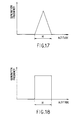
- random number data is constructed using Gaussian distribution random number, and on the basis of the random number the altitude data is constructed.
- the method of producing random number is not limited to this but the random number may be constructed with a generation probability for example as illustrated in FIGS. 17 and 18.
- the deviation may be switched to a deviation represented by the character H.
- the altitude data is corrected using the coastline pattern memory which distinguishes land and sea with a coastline interposed.
- the present invention is not limited to this but may be widely applied to a case where the altitude data is corrected on the basis of a pattern memory of two dimensional topographical data which distinguishes areas other than land and sea.
- two dimensional topographical data is inputted by operator's manual input
- the present invention is not restricted to this.
- an image of a map which have land and sea distinguished with colors may be picked up, and based on the result picked up, two dimensional topographical data may be automatically inputted.
- the altitude data is constructed detecting the coastline, but the present invention is not limited to this.
- the present invention may be widely applied to cases where altitude data is constructed using various references representing configuration such as contour line.
- the present invention can provide a topographical data construction system which is capable of constructing topography which provides a natural impression with ease by correcting altitude data based on a pattern memory, which distinguishes land and the other areas, every time the altitude data is constructed in constructing three dimensional topographical data using fractal technique.
Landscapes
- Physics & Mathematics (AREA)
- Engineering & Computer Science (AREA)
- General Physics & Mathematics (AREA)
- Theoretical Computer Science (AREA)
- Computer Graphics (AREA)
- Geometry (AREA)
- Software Systems (AREA)
- Processing Or Creating Images (AREA)
- Instructional Devices (AREA)
Claims (6)
- System (1) zum Konstruieren von topographischen Daten, in dem Höhendaten (GH) auf der Basis von zweidimensionalen topographischen Daten (D2) konstruiert werden und auf der Basis der so konstruierten zweidimensionalen topographischen Daten und der Höhendaten (DH) dreidimensionale topographische Daten (D3) konstruiert werden, wobei das System aufweist:eine Eingabeeinrichtung (24) zur Eingabe von Höhendaten, die einer Mehrzahl von optionalen repräsentativen Punkten (P) einer durch zweidimensionale topographische Daten (D2) dargestellten Topographie entsprechen,eine Teilungspunkt-Setzeinrichtung (21) zum Setzen von Teilungspunkten (T) zwischen benachbarten repräsentativen Punkten aus der Mehrzahl von repräsentativen Punkten,eine Abweichungs-Setzeinrichtung (21) zum Setzen einer Abweichung auf der Basis des Abstands von den Teilungspunkten (T) zu den den Teilungspunkten (T) benachbarten repräsentativen Punkten (P),eine Konstruktionseinrichtung (21) zum Konstruieren von Höhendaten der Teilungspunkte (T) unter Verwendung einer Zufallszahlenfunktion auf der Basis von Daten, die die Höhe der benachbarten Punkte (P) und die Abweichung repräsentieren, undeine Korrektureinrichtung (21) zum Korrigieren der Höhendaten der Teilungspunkte (T) auf der Basis von Daten (L1), die fur eine Grenze zwischen Land und Meer reprasentativ sind, wobei die Korrektureinrichtung (21) die Höhendaten der Teilungspunkte (T), die in dem Meer liegen, auf die Höhendaten des Meeresspiegels setzt.
- System zum Konstruieren von topographischen Daten nach Anspruch 1, ferner mit einer Einrichtung (21) zum Konstruieren von zweidimensionalen topographischen Daten aus einem Bild, das durch bilderzeugende Abtastung einer Landkarte gewonnen wird.
- System zum Konstruieren von topographischen Daten nach Anspruch 1, ferner mit einer Einrichtung zum Konstruieren von die Grenze zwischen Land und Meer angebenden Küstenlinienmusterdaten aus dem durch die bilderzeugende Abtastung einer Landkarte gewonnenen Bild.
- System zum Konstruieren von topographischen Daten nach Anspruch 3, bei dem die Zufallszahlenfunktion durch folgende Gleichung ausgedrückt wird:
- Verfahren zum Konstruieren von topographischen Daten auf der Basis von zweidimensionalen topographischen Daten (D2) und Hohendaten (DH), die auf der Basis der zweidimensionalen topographischen Daten konstruiert werden, mit den Verfahrensschritten:(a) Setzen (24) der Höhendaten (DH) für eine Mehrzahl von optionalen repräsentativen Punkten (P), die jeweils durch die zweidimensionalen topographischen Daten (22) angegeben werden,(b) Setzen (21) von Teilungspunkten (T) zwischen benachbarten repräsentativen Punkten (P) aus der Mehrzahl von repräsentativen Punkten (P),(c) Setzen (21) einer Abweichung auf der Basis des Abstands von den Teilungspunkten (T) zu den den Teilungspunkten (T) benachbarten repräsentativen Punkten (P),(d) Konstruieren von Höhendaten der Teilungspunkte (T) unter Verwendung einer Zufallszahlenfunktion auf der Basis von Höhendaten der benachbarten Punkte (P) und der Abweichung,(e) Korrigieren (21) der Höhendaten der Teilungspunkte (T) auf der Basis von die Grenze zwischen Land und Meer angebenden Daten, wobei die Korrektureinrichtung (21) die Höhendaten der Teilungspunkte (T), die in dem Meer liegen, auf die Höhendaten des Meeresspiegels setzt.
- Verfahren nach Anspruch 5, gekennzeichnet durch das Wiederholen der Schritte (b) bis (e), wobei die genannten Teilungspunkte als die repräsentativen Punkte verwendet werden.
Applications Claiming Priority (3)
| Application Number | Priority Date | Filing Date | Title |
|---|---|---|---|
| JP22605090 | 1990-08-28 | ||
| JP226050/90 | 1990-08-28 | ||
| JP2226050A JP3063125B2 (ja) | 1990-08-28 | 1990-08-28 | 地形データ作成装置 |
Publications (3)
| Publication Number | Publication Date |
|---|---|
| EP0473152A2 EP0473152A2 (de) | 1992-03-04 |
| EP0473152A3 EP0473152A3 (en) | 1993-04-21 |
| EP0473152B1 true EP0473152B1 (de) | 1999-10-27 |
Family
ID=16839008
Family Applications (1)
| Application Number | Title | Priority Date | Filing Date |
|---|---|---|---|
| EP91114532A Expired - Lifetime EP0473152B1 (de) | 1990-08-28 | 1991-08-28 | Topographisches Datenaufbausystem |
Country Status (4)
| Country | Link |
|---|---|
| EP (1) | EP0473152B1 (de) |
| JP (1) | JP3063125B2 (de) |
| KR (1) | KR920005012A (de) |
| DE (1) | DE69131744T2 (de) |
Families Citing this family (6)
| Publication number | Priority date | Publication date | Assignee | Title |
|---|---|---|---|---|
| FR2716061B1 (fr) * | 1994-02-04 | 1996-03-15 | Thomson Broadcast | Procédé de génération d'images texturées et d'effets spéciaux en vidéo et dispositif pour la mise en Óoeuvre du procédé. |
| US5751293A (en) * | 1994-08-24 | 1998-05-12 | Nippon Telegraph And Telephone Corp. | Pattern generation method and apparatus for automatic generation of continuous tile patterns along any arbitrary side |
| JP3375258B2 (ja) * | 1996-11-07 | 2003-02-10 | 株式会社日立製作所 | 地図表示方法及び装置並びにその装置を備えたナビゲーション装置 |
| KR100393185B1 (ko) * | 1996-12-20 | 2004-01-24 | 삼성전자주식회사 | 삼차원구조 데이터와 그래픽스 오브젝트의 합성장치 및 그 방법 |
| KR20010113703A (ko) | 1999-02-19 | 2001-12-28 | 구타라기 켄 | 굴절 매핑을 실행하는 시스템 및 방법 |
| KR100380256B1 (ko) * | 2000-08-31 | 2003-04-16 | 글로리맵 주식회사 | 위치 정보 안내판 제작방법 |
Family Cites Families (1)
| Publication number | Priority date | Publication date | Assignee | Title |
|---|---|---|---|---|
| FR2610752B1 (fr) * | 1987-02-10 | 1989-07-21 | Sagem | Procede de representation de l'image en perspective d'un terrain et systeme pour sa mise en oeuvre |
-
1990
- 1990-08-28 JP JP2226050A patent/JP3063125B2/ja not_active Expired - Fee Related
-
1991
- 1991-08-22 KR KR1019910014487A patent/KR920005012A/ko not_active Application Discontinuation
- 1991-08-28 EP EP91114532A patent/EP0473152B1/de not_active Expired - Lifetime
- 1991-08-28 DE DE69131744T patent/DE69131744T2/de not_active Expired - Fee Related
Also Published As
| Publication number | Publication date |
|---|---|
| EP0473152A2 (de) | 1992-03-04 |
| KR920005012A (ko) | 1992-03-28 |
| JP3063125B2 (ja) | 2000-07-12 |
| EP0473152A3 (en) | 1993-04-21 |
| DE69131744D1 (de) | 1999-12-02 |
| JPH04107687A (ja) | 1992-04-09 |
| DE69131744T2 (de) | 2000-06-29 |
Similar Documents
| Publication | Publication Date | Title |
|---|---|---|
| US20040176908A1 (en) | Map displaying apparatus | |
| US7586489B2 (en) | Method of generating surface defined by boundary of three-dimensional point cloud | |
| US4940972A (en) | Method of representing a perspective image of a terrain and a system for implementing same | |
| US7764282B2 (en) | Visualizing system, visualizing method, and visualizing program | |
| CN103761397B (zh) | 用于面曝光增材成型的3d模型切片及投影面生成方法 | |
| US7629972B2 (en) | Image-based protruded displacement mapping method and bi-layered displacement mapping method using the same | |
| CN107170040A (zh) | 一种三维桥梁场景构建方法和装置 | |
| CN115409957A (zh) | 基于虚幻引擎的地图构建方法、电子设备和存储介质 | |
| EP0473152B1 (de) | Topographisches Datenaufbausystem | |
| US6433790B1 (en) | Methods and systems for rendering line and point features for display | |
| US5550959A (en) | Technique and system for the real-time generation of perspective images | |
| CN115409962B (zh) | 虚幻引擎内构建坐标系统的方法、电子设备和存储介质 | |
| JPH0636013A (ja) | 地形データの作成方法および装置 | |
| JP3063134B2 (ja) | 地形データ作成装置 | |
| JP3979162B2 (ja) | 画像処理装置およびその方法 | |
| TWI746150B (zh) | 超解析度立體視覺化處理系統及其程式 | |
| JP3024666B2 (ja) | 高々度撮影々像の三次元表示映像生成方法および生成システム | |
| JPH1185012A (ja) | 立体地図描画方法、それを使用するナビゲーションシステム及び立体地図描画プログラムを記録した記録媒体 | |
| US5821942A (en) | Ray tracing through an ordered array | |
| JPH096941A (ja) | 3次元地形データ変換装置 | |
| Scarlatos | Spatial data representations for rapid visualization and analysis | |
| Peucker | The use of computer graphics for displaying data in three dimensions | |
| JP3206209B2 (ja) | 3次元コンピュータグラフィックスにおける図形の配置手法及び装置 | |
| CN111506680B (zh) | 地形数据生成、渲染方法及装置、介质、服务器、终端 | |
| JP3376884B2 (ja) | 立体地形表示装置 |
Legal Events
| Date | Code | Title | Description |
|---|---|---|---|
| PUAI | Public reference made under article 153(3) epc to a published international application that has entered the european phase |
Free format text: ORIGINAL CODE: 0009012 |
|
| AK | Designated contracting states |
Kind code of ref document: A2 Designated state(s): DE FR GB |
|
| PUAL | Search report despatched |
Free format text: ORIGINAL CODE: 0009013 |
|
| AK | Designated contracting states |
Kind code of ref document: A3 Designated state(s): DE FR GB |
|
| 17P | Request for examination filed |
Effective date: 19930922 |
|
| 17Q | First examination report despatched |
Effective date: 19961125 |
|
| GRAG | Despatch of communication of intention to grant |
Free format text: ORIGINAL CODE: EPIDOS AGRA |
|
| GRAG | Despatch of communication of intention to grant |
Free format text: ORIGINAL CODE: EPIDOS AGRA |
|
| GRAG | Despatch of communication of intention to grant |
Free format text: ORIGINAL CODE: EPIDOS AGRA |
|
| GRAH | Despatch of communication of intention to grant a patent |
Free format text: ORIGINAL CODE: EPIDOS IGRA |
|
| GRAH | Despatch of communication of intention to grant a patent |
Free format text: ORIGINAL CODE: EPIDOS IGRA |
|
| GRAA | (expected) grant |
Free format text: ORIGINAL CODE: 0009210 |
|
| AK | Designated contracting states |
Kind code of ref document: B1 Designated state(s): DE FR GB |
|
| REF | Corresponds to: |
Ref document number: 69131744 Country of ref document: DE Date of ref document: 19991202 |
|
| ET | Fr: translation filed | ||
| PLBE | No opposition filed within time limit |
Free format text: ORIGINAL CODE: 0009261 |
|
| STAA | Information on the status of an ep patent application or granted ep patent |
Free format text: STATUS: NO OPPOSITION FILED WITHIN TIME LIMIT |
|
| 26N | No opposition filed | ||
| PGFP | Annual fee paid to national office [announced via postgrant information from national office to epo] |
Ref country code: FR Payment date: 20010810 Year of fee payment: 11 |
|
| PGFP | Annual fee paid to national office [announced via postgrant information from national office to epo] |
Ref country code: DE Payment date: 20010820 Year of fee payment: 11 |
|
| PGFP | Annual fee paid to national office [announced via postgrant information from national office to epo] |
Ref country code: GB Payment date: 20010822 Year of fee payment: 11 |
|
| REG | Reference to a national code |
Ref country code: GB Ref legal event code: IF02 |
|
| PG25 | Lapsed in a contracting state [announced via postgrant information from national office to epo] |
Ref country code: GB Free format text: LAPSE BECAUSE OF NON-PAYMENT OF DUE FEES Effective date: 20020828 |
|
| PG25 | Lapsed in a contracting state [announced via postgrant information from national office to epo] |
Ref country code: DE Free format text: LAPSE BECAUSE OF NON-PAYMENT OF DUE FEES Effective date: 20030301 |
|
| GBPC | Gb: european patent ceased through non-payment of renewal fee |
Effective date: 20020828 |
|
| PG25 | Lapsed in a contracting state [announced via postgrant information from national office to epo] |
Ref country code: FR Free format text: LAPSE BECAUSE OF NON-PAYMENT OF DUE FEES Effective date: 20030430 |
|
| REG | Reference to a national code |
Ref country code: FR Ref legal event code: ST |